2017 Canadian Consulting Engineering Awards
|
|
|
- Barnaby Fletcher
- 5 years ago
- Views:
Transcription


1 2017 Canadian Consulting Engineering Awards Northeast Anthony Henday Drive DBFO Edmonton, Alberta
2 Four years of detours, traffic snarls, varying speed limits, and stop-and-start driving has come to an end for drivers in Edmonton, Alberta, Canada, with the completion of the northeast stretch of Anthony Henday Drive.
3 With an economical design, integrated management approach and close coordination with the construction group, AECOM reduced time, costs and associated risks to deliver a successful project.
4


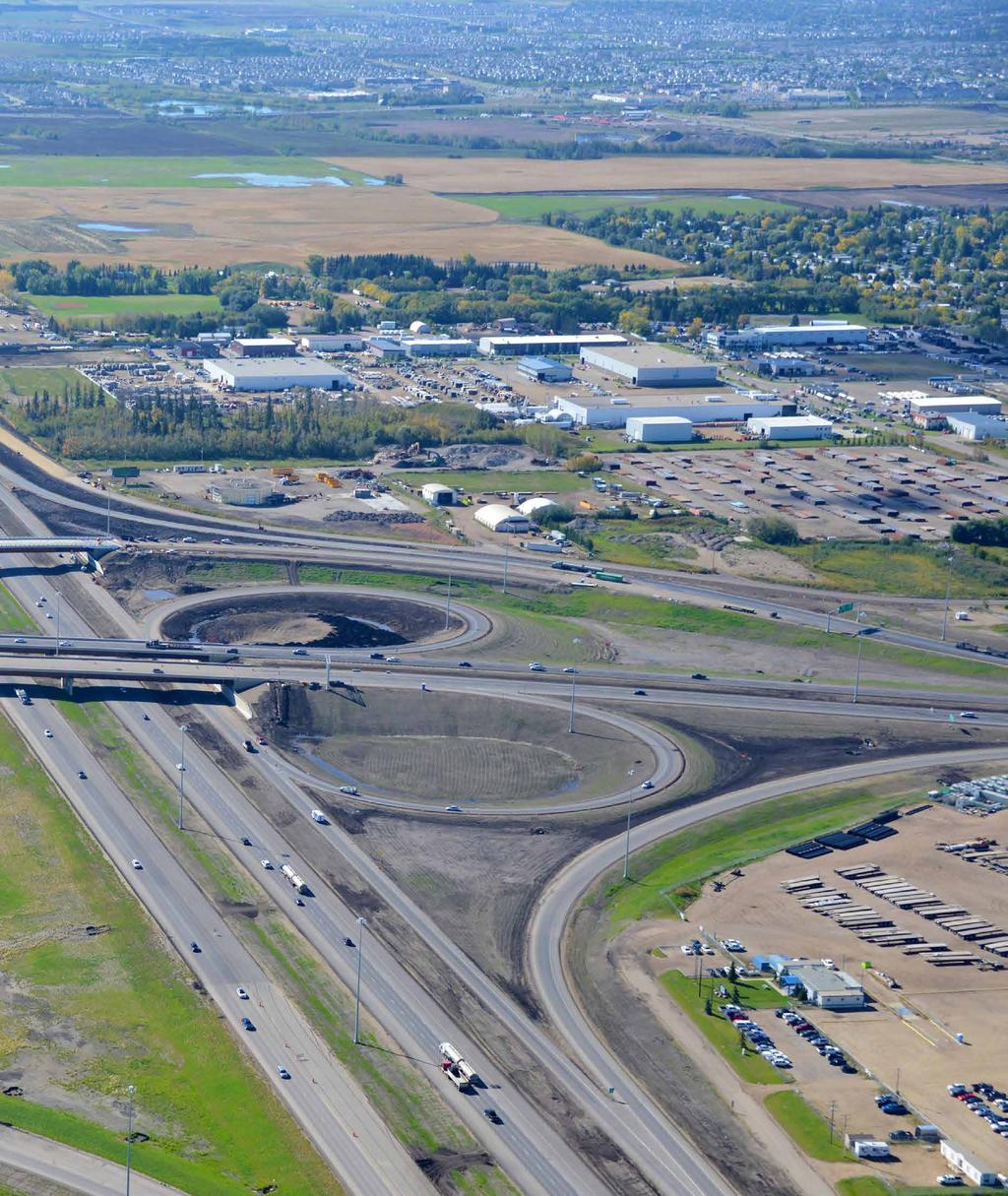
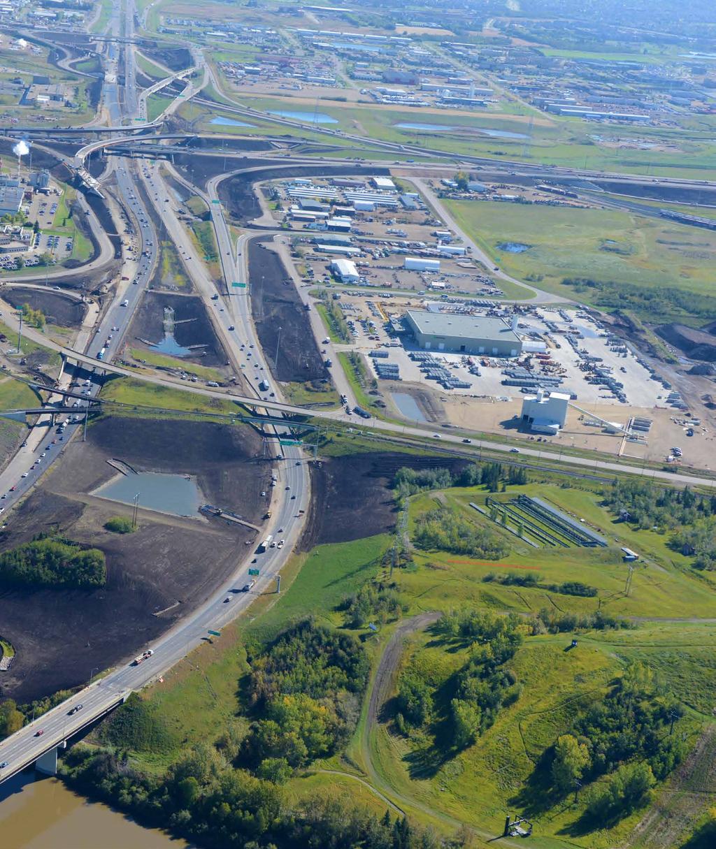
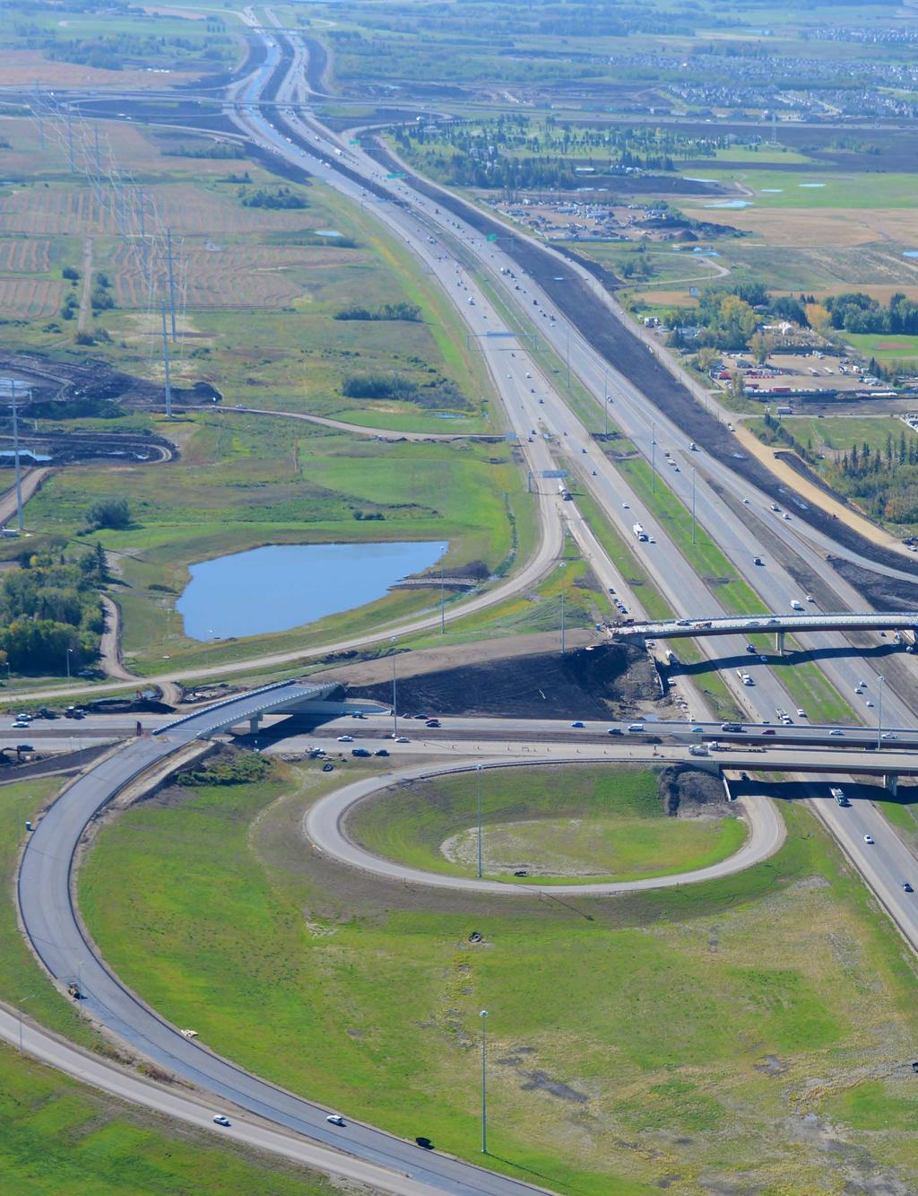
5 Summary The Northeast Anthony Henday Drive is a $1.8-billion P3 project involving 27 km of new 8-lane freeway with 46 bridge structures to complete Edmonton s ring road. Construction of bridges over old mines, numerous major pipeline relocations, the North Saskatchewan River crossing, replacement of interchange and rail bridges while maintaining service were challenges faced by Capital City Link and contractor FDAL. At award, this was the largest transportation contract ever signed by the Alberta Government. The roadway system is an integral component of Edmonton s ring road as well as the province s overall transportation network. AECOM ACEC/CCE Awards 2017 Northeast Anthony Henday Drive DBFO 2

6 Innovation As one of the busiest roads in Western Canada the Anthony Henday Drive roads encircling the City of Edmonton has been created with the interests of stakeholders in mind, such as the Alberta Government, the Federal Department of National Defense, and the numerous daily commuters. A multi-discipline design approach was taken to reduce bridge spans through the use of mechanically stabilized earth (MSE) walls, which allowed use of integral abutment designs that eliminated the bridge bearings and expansion joints, and reduced superstructure depths. Geotechnical designers developed options appropriate for soil conditions at each site, and the MSE walls allowed interchange profiles to be optimized, reducing fill heights and eliminating encroachment outside the road right-of-way or maintaining separation from utility right-of-ways. A unique combination of retaining walls ranging from shallow footings to pile supported walls along with down slope stabilization piles were used for the North Saskatchewan River bridges to maintain a steeper headslope, reduce bridge length and excavation while accommodating pedestrians and wildlife on separate pathways. Bridge foundations over an old mine site where there were voids at variable depths had to be designed to accommodate potential collapse of voids. Designs varied from raft foundations to deep piles with casings that penetrated through the mined areas into the bedrock below. The pavement engineering utilized a special modeling program to evaluate pavement design options and resulted in an innovative use of existing materials, reducing the use of non-renewable aggregate resources and lowering greenhouse gas Preserving our environment: safe wildlife passage was maintained and integrated along the North Saskatchewan River corridor. emissions without sacrificing pavement quality and performance. Pavement design was optimized with the performance models developed specifically for the project, using historical performance data from adjacent highways. Materials were selected to eliminate the potential for low temperature induced cracking, reducing future maintenance, rehabilitation activities, and delays to the traveling public. Replacement of impacted wetlands was a requirement of the Provincial Water Act, however, the Federal Department of National Defense had a designated Bird Hazard Zone over portions of the project that prohibited creation of habitat for waterfowl. Environmental, drainage and landscape designers developed designs with limited open water, longer narrow channels, and plantings to deter birds that could be potential hazards for aircraft bird strikes. To promote barrier-free design and avoid future costs, ditches, back slopes and appurtenances were constructed and installed in permanent locations. The pavement structure was limited to requirements called for at this stage. 3 Northeast Anthony Henday Drive DBFO ACEC/CCE Awards 2017 AECOM


7 Complexity Multi-discipline Complex Project The Northeast Anthony Henday Drive project consisted of 27 km of 8-lane divided freeway with 189 lane km of roadway, 9 service interchanges, 7 grade separations, 46 bridge structures with 12 bridges constructed while existing roadways remained operational,103 overhead sign structures, and 70 impacted wetlands. The design team who worked for the construction group Flatiron-Dragados-Aecon-LaFarge JV (FDAL) was constantly challenged to be innovative in achieving the most cost-effective designs, while meeting technical requirements and an aggressive project schedule. Aggressive Timeline To advance construction, design and approval procurement commenced upon notification of Preferred Proponent. A design deliverable management program and fully-integrated design and construction schedule was developed and monitored weekly, as design and construction were executed concurrently. Planning and design of the bridge structures accommodated an aggressive construction schedule, with structures designed to allow earthworks and bridges to be built independently. Utility Coordination Over 500 utilities, including many major pipelines, needed protection or relocation which required close coordination between design disciplines, contractor and the many utility companies. An extensive hydrovac program was undertaken and designs were modified to avoid conflicts to the extent possible. Partnership among client, design, management and construction interests Design leads, construction management, operation and maintenance representatives and concession managers were co-located on site. Designers and the contractor discussed design challenges daily to produce constructible, technically-compliant designs. Formal contractor reviews were completed on all design packages at 4 stages during the design development, and weekly meetings were held with Alberta Transportation to review submittal packages. Looking South from CN mainline crossing Yellowhead Tr. AECOM ACEC/CCE Awards 2017 At North Saskatchwan River looking east at Yellowhead Tr. Northeast Anthony Henday Drive DBFO 4


8 Social and/or Economic Benefits The Northeast Anthony Henday freeway forms the final link on a heavily travelled commuter and truck bypass route that carries more than 105,000 vehicles per day and has significantly improved commuting around Edmonton and the movement of goods and services around the province. Reduced congestion equates to reduced greenhouse gas emissions due to reduced idling time. The freeway is improving commuting around Edmonton, and the movement of goods and services around the province. NEAHD increases development potential in adjacent areas, through better access to the rest of the city. Surrounding communities will see an increase in property value, resulting from shorter commute times and easier access. Traffic will have an alternative to the signalized Yellowhead Trail corridor through Edmonton and free flow roadways have fewer collisions resulting in safer, more efficient highways. Advancement of knowledge Technical knowledge was advanced by merging engineering and construction knowledge and resulted in development of economical designs. Optimization of bridge areas, construction of bridge foundations over old mines, pavement designs and staging of roadway pavements, and working together with Environmental Regulators resulted in a much better understanding of bridge, roadway, drainage and utility constructability. CN Rail crossing adjacent to 18 th Street. 5 Northeast Anthony Henday Drive DBFO ACEC/CCE Awards 2017 AECOM


9 Environmental Benefits The stormwater management system involved integration of compensatory developed and constructed wetlands with stormwater management objectives and features. There were 24 hectares of existing wetlands that could not be avoided by the roadway and ditching geometries. In accordance with the provincial Wetland Management in the Settled Area of Alberta, these needed to be compensated for at a 3 to 1 ratio, resulting in approximately 73 hectares of wetland habitat compensation. This was achieved through the construction of 12 naturalized stormwater management facilities that created 50 ha of newly constructed wetland habitat. The remainder of required compensation was achieved through a financial contribution to Ducks Unlimited Canada s Cooking Lake Initiative. A detailed study of the Sturgeon fish species in the area of the North Saskatchewan River bridges was conducted, and fish habitat compensation was developed accordingly in the North Saskatchewan River. AECOM provided hydrological and hydraulic modeling and environmental design for the naturalized stormwater management facilities that function as constructed wetlands, and are designed to achieve 85% removal of particle sizes greater than or equal to 75 microns. Previously installed culverts were well above the stream bed of creeks and were largely impassible for fish species. New drainage structures on several natural creeks resulted in improvements to fish habitat, as the new structures were counter sunk to facilitate habitat connectivity. Storm ponds adjacent to the community of Sherwood Park were oversized and used to correct pre-existing stormwater storage shortfalls. 153 Avenue Interchange looking South to river crossing. AECOM ACEC/CCE Awards 2017 Northeast Anthony Henday Drive DBFO 6

10 Meeting Client s Needs The Alberta Government needed the final link of the ring road to be constructed within a set time and with price certainty. The Northeast Anthony Henday Project was delivered on time and on budget under a lump sum contract, with a defined 30-year operations and maintenance component that warrantees the project. The success of the P3 model paired with the concurrent design build concept of this project provided the Province of Alberta and Alberta Transportation with a unique way to fund and quickly complete future large-scale projects. Risk reduction is a major objective on complex P3 projects. Under a P3 model, the infrastructure is maintained by the Concession for the 30-year concession period. As such, they have a responsibility to ensure the infrastructure will be in good standing throughout the maintenance period and at the time of hand back. Within such a scenario, the Concession has a vested interest to ensure the products are of a high quality to minimize its overall maintenance costs, reducing long term risks attributed to Alberta in a conventional bid-build. Opportunity for the Alberta Industry lies in recognizing the combined experiences of engineering consultants and contractors can be injected into Department processes to suit the P3 delivery model which requires construction to proceed ahead of all design work being completed. Northeast Anthony Henday Drive not only acts as a successful case study for transportation projects, but the project management and funding partnerships formed can also be applied to other construction-based traditional design bid build projects. 7 Northeast Anthony Henday Drive DBFO ACEC/CCE Awards 2017 AECOM
11
12
13 The roadway system is an integral component of Edmonton s ring road as well as the province s overall transportation network.

14 ACEC/CCE Awards 2017 About AECOM AECOM is built to deliver a better world. We design, build, finance and operate infrastructure assets for governments, businesses and organizations in more than 150 countries. As a fully integrated firm, we connect knowledge and experience across our global network of experts to help clients solve their most complex challenges. From high-performance buildings and infrastructure, to resilient communities and environments, to stable and secure nations, our work is transformative, differentiated and vital. A Fortune 500 firm, AECOM had revenue of approximately $17.4 billion during fiscal year See how we deliver what others can only imagine at aecom.com
Northeast Anthony Henday Drive Manning Freeway to Whitemud Drive Welcome to this Construction Information Session
 Manning Freeway to Whitemud Drive Welcome to this Construction Information Session Purpose To inform interested residents and businesses about the plans accommodation. Background: The Government of Alberta
NORTHEAST RIVER CROSSING FUNCTIONAL PLANNING STUDY
 WELCOME Northeast River Crossing Functional Planning Study Phase 2 Public Meeting 4 to 8 PM Informal drop-in format and discussion tables Meeting Purpose Introduce the Northeast River Crossing Functional
WELCOME 50 street cp rail grade separation + road widening. public information session #1 June 26, pm to 8 pm
 WELCOME 50 street cp rail grade separation + road widening public information session #1 June 26, 2018 5 pm to 8 pm session purpose To provide residents, businesses, and users of 50 Street with the opportunity
TRANSPORTATION: Roads and Highways Services
 TRANSPORTATION: Roads and Highways Services Profile Our background GIBB is a leading multi-disciplinary engineering consulting firm based in South Africa with 67% Black ownership. The firm has a strong
Illiana Corridor CPG/TTF Meeting #1
 Illiana Corridor CPG/TTF #1 March 14, 2013 #10 1 Agenda Tier One Recap What happens in Tier Two? Tier Two Purpose and Need Identify Range of Alternatives Landowner Outreach Initial Context Sensitive Solution
GREEN SHEET ENVIRONMENTAL COMMITMENTS FOR THE IOWA HIGHWAY 100 EXTENSION
 County: Linn County, IA GREEN SHEET Location: IA 100, from its terminus at Edgewood Rd. to US 30 southwest of Cedar Rapids Route: IA 100 Extension Project No.: NHS-100-1(36) 19-57 OLE Project Managers:
Red Hill Valley Project More Than A Road October 16, 2006
 Red Hill Valley Project Presented By: More Than A Road October 16, 2006 September, 2007 Gerry Davis, C.M.A., Senior Director, Capital Planning and Implementation Division Public Works Department City of
Welcome. Mill Creek Ravine Pedestrian Bridges Rehabilitation. Public Information Session #1. Thursday, October 27, :00 8:00 p.m.
 Welcome Mill Creek Ravine Pedestrian Bridges Rehabilitation Public Information Session #1 Thursday, October 27, 2016 5:00 8:00 p.m. Tonight you can: Learn about the rehabilitation of 5 pedestrian bridges
WELCOME! 8 8:30 6: TH STREET IMPROVEMENTS. Open House. Presentation & Q&A
 WELCOME! 168 TH STREET IMPROVEMENTS 6:30 Open House 7 8 Presentation & Q&A 8 8:30 Open House WELCOME Todd Pfitzer City of Omaha Engineer Bob Stubbe City of Omaha Public Works Director Jon Meyer Project
Better Cycling. The City will update the cycling master plan (London ON Bikes) based on the approved BRT network.
 based on the approved BRT network.") Better Cycling Dedicated bike facilities will be constructed along BRT corridors where space is available. Nearby bike routes will also be upgraded to ensure a complete network is available for cyclists.
Better Cycling Dedicated bike facilities will be constructed along BRT corridors where space is available. Nearby bike routes will also be upgraded to ensure a complete network is available for cyclists.
The purpose of tonight s PIC is to:
 The purpose of tonight s PIC is to: Provide an overview of the work completed to date and a summary of the Class EA process being followed; Provide a summary of public input received so far, including
Mavis Road Class Environmental Assessment
 Mavis Road Class Environmental Assessment Public Information Centre #2 Wednesday November 9, 2016 6:00 to 8:00 p.m. Please sign in and complete a comment sheet Review the displays on your own or join in
OP Council Resolution June 16, Planning and Development Services
 OP-08-01 Council Resolution June 16, 2008 Planning and Development Services Kingsgate Landing Outline Plan Table of Contents 1.0 Introduction 1 1.1 Purpose of Plan 1 1.2 Plan Area Location 1 1.3 Ownership
TOWN OF WHITBY REPORT RECOMMENDATION REPORT
 TOWN OF WHITBY REPORT RECOMMENDATION REPORT REPORT TO: Council REPORT NO: PL 95-09 DATE OF MEETING: October 13, 2009 PREPARED BY: Planning/Public Works Joint Report FILE NO(S): N/A LOCATION: N/A REPORT
Slope Stability Management Framework
 Slope Stability Management Framework For the assessment, evaluation, prioritization and mitigation of slope stability concerns. 2013/06/19 The Slope Stability Management Framework provides guidance to
North Commuter Parkway and Traffic Bridge Project Market Sounding
 North Commuter Parkway and Traffic Bridge Project Market Sounding Introduction KPMG LLP ( KPMG ) has been engaged by the City of Saskatoon ( the City ) to develop a P3 business case for the North Commuter
Stormwater Regulations & Considerations Morse Study Area. Pam Fortun, P.E. CFM Senior Stormwater Treatment Engineer Engineering Services Division
 Stormwater Regulations & Considerations Morse Study Area Pam Fortun, P.E. CFM Senior Stormwater Treatment Engineer Engineering Services Division Stormwater Regulations Development Considerations Floodplain
The West Vaughan Employment Area Secondary Plan Policies
 Part 2: The West Vaughan Employment Area Secondary Plan Policies 2.1 General Policies It is the policy of Council: 2.1.1. That the West Vaughan Employment Area (the WVEA), identified on Schedule 1, will
DESIGN CRITERIA PACKAGE
 RFQ: 17-C-00003 DESIGN-BUILD SERVICES FOR THE DESIGN CRITERIA PACKAGE PREPARED BY: JAMES E. JACKSON, JR. AIA CITY ARCHITECT CONTRACT ADMINISTRATION DEPARTMENT and INTERFLOW ENGINEERING, L.L.C DESIGN CRITERIA
What We Heard Public Engagement - Stage 1
 What We Heard Public Engagement - Stage 1 Background Early planning is underway for a potential new river crossing over the North Saskatchewan River, in the northeast part of the Edmonton region. The City
Cleveland Innerbelt Bridge / Central Viaduct City Planning Commission November 6, 2009
 Cleveland Innerbelt Bridge / Central Viaduct City Planning Commission November 6, 2009 Process for Aesthetics Subcommittee June 25, 2009 Kick off Meeting June 26, 2009 Gateway and Tremont Focus Groups
Edmonton s LRT Setting the Stage for Heading Further South
 4 Capital Projects Project Updates Edmonton s LRT Setting the Stage for Heading Further South Art Washuta, P.Eng. AECOM Canada Ltd. Edmonton, Alberta Carole Cej, P.Eng. City of Edmonton Edmonton, Alberta
Meeting Purpose: Date and Time: Location: Attendance: Handouts:
 Meeting Purpose: Date and Time: Location: Attendance: Handouts: PA Turnpike / I-95 Interchange Project Design Advisory Committee (DAC)/Public Officials Meeting #8 April 12, 2012 at 1:30 p.m. Project Office,
Kankakee River Bridge & Track Improvements Supplemental Environmental Assessment. May 5, 2016
 Kankakee River Bridge & Track Improvements Supplemental Environmental Assessment May 5, 2016 1 History: Chicago-St. Louis Corridor Since 1980 s IDOT has been looking at this corridor for high-speed service
Shift Rapid Transit Public Participation Meeting May 3, 2017
 Shift Rapid Transit Public Participation Meeting May 3, 2017 Shift Rapid Transit Initiative Largest infrastructure project in the city s history. Rapid Transit initiative will transform London s public
APWA Expo August 27, Ground Water Recharge With Storm Management: A Sustainable Development
 APWA Expo August 27, 2013 Ground Water Recharge With Storm Management: A Sustainable Development Presented by: Joel S. Koenig, P.E. Andrew J. Hawkins Chris P. Dagiantis, P.E., CFM Bios Joel S. Koenig,
EXECUTIVE SUMMARY. Introduction
 Introduction EXECUTIVE SUMMARY The Urban Service Area Fort McMurray (hereafter referred to as the Urban Service Area) is currently experiencing a variety of development pressures. Unprecedented population
I-494 Rehabilitation Project SP (I-394 to Fish Lake Interchange) June 2014 Section 4(f) De Minimis Determination
 June 2014 Section 4(f) De Minimis Determination") I-494 Rehabilitation Project SP 2785-330 (I-394 to Fish Lake Interchange) June 2014 Section 4(f) De Minimis Determination State Project Number 2785-330 Federal Project No. NHPP-I494 (002) Trunk Highway:
I-494 Rehabilitation Project SP 2785-330 (I-394 to Fish Lake Interchange) June 2014 Section 4(f) De Minimis Determination State Project Number 2785-330 Federal Project No. NHPP-I494 (002) Trunk Highway:
CAPITAL LINE SOUTH LRT EXTENSION INTRODUCTION
 INTRODUCTION What: The 2010 preliminary design for the Capital Line South LRT Extension will run from the Century Park Station to Ellerslie Road. It will connect to the Heritage Valley Park and Ride located
Route 7 Reconstruction and Widening, Wilton. State Project Nos & 124. Wolf Pit Road to just north of Olmstead Hill Road
 Route 7 Reconstruction and Widening, Wilton State Project Nos. 161-118 & 124 Wolf Pit Road to just north of Olmstead Hill Road Tonight s Agenda Introduction Bill Brennan, Wilton First Selectman Construction
Rapid Transit Implementation Working Group September 14, 2017
 Rapid Transit Implementation Working Group September 14, 2017 BACKGROUND Council approved the Rapid Transit Master Plan and Updated Business Case on July 25, 2017. Approval of the RTMP confirmed the BRT
Inform you of the purpose and scope of the study for PTH 100 and a proposed future St. Norbert Bypass;
 WELCOME The intent of today s Open House is to: Inform you of the purpose and scope of the study for PTH 100 and a proposed future St. Norbert Bypass; Review highway crossing locations, future access closures
INFRASTRUCTURE EXISTING INFRASTRUCTURE A. Circulation B. Signals C. Drainage D. Utilities
 7.01. EXISTING INFRASTRUCTURE A. Circulation B. Signals C. Drainage D. Utilities 7.02. PROPOSED INFRASTRUCTURE A. Overall Concept B. Circulation C. Signals D. Drainage 7.03. INFRASTRUCTURE MAP A. Key Infrastructure
2018 Priority Regional Transportation Projects. Integrated Regional Transportation Master Plan
 2018 Priority Regional Transportation Projects June 14, 2018 Table of Contents 1.0 INTRODUCTION 3 1.1 BACKGROUND 3 1.2 OBJECTIVES 3 2.0 METHODOLOGY 4 2.1 OVERVIEW OF EVALUATION PROCESS 4 2.2 PROJECT LIST
Low Level Road Project. Canadian Consulting Engineers Award 2016
 Low Level Road Project Canadian Consulting Engineers Award 2016 A local resident enjoys a forested section of the Spirit Trail, which connects to Moodyville Park near the east abutment of the Woodland
Planning Districts INTRODUCTION
 INTRODUCTION To facilitate detailed examination of development prospects for all areas of the community, Delano has been divided into 14 planning districts. The location of these planning districts is
Red Fox Commercial Outline Plan
 Red Fox Commercial Outline Plan City of Cold Lake, Alberta Prepared by Durrance Projects Ltd and Ross W. Sharp & Associates Ltd October 2014 Rupert 1 Table of Contents 1. PURPOSE...3 1.1. Location...4
Chapter 5: Natural Resources and Environment
 NATURAL RESOURCES AND ENVIRONMENT 5-1 5 Chapter 5: Natural Resources and Environment BACKGROUND AND INTENT Urban expansion represents the greatest risk for the future degradation of existing natural areas,
The Illinois Department of Transportation and Lake County Division of Transportation. Route 173, including the Millburn Bypass
 The Illinois Department of Transportation and Lake County Division of Transportation welcome you to this Public Hearing for U.S. Route 45 from Illinois Route 132 to Illinois Route 173, including the Millburn
WELCOME TO THE PUBLIC INFORMATION CENTRE. Please Sign In
 WELCOME TO THE PUBLIC INFORMATION CENTRE Replacement of Oxtongue Lake Narrows Bridge & Oxtongue River Bridge, Highway 60 (G.W.P. 93-89-00 & G.W.P. 5550-04-00) Class Environmental Assessment (Group B) Please
Aurum Industrial Business Park Area Structure Plan
 Aurum Industrial Business Park Area Structure Plan Office Consolidation September 2017 Prepared by: Planning and Policy Services Branch Planning and Development Department City of Edmonton Bylaw 9809 was
Great Lakes North Central South Central FAX: (718) CONTACT PERSON: ADDRESS: Daniel Hom, PE, Engineer-in-Charge
 CONTACT PERSON: ADDRESS: Daniel Hom, PE, Engineer-in-Charge") AMERICAN SOCIETY OF HIGHWAY ENGINEERS National Project of the Year Award OFFICIAL ENTRY FORM AWARD CATEGORY (Check One): Under $20 Million Over $20 Million SPONSORING REGION (Check One): Northeast Mid-Atlantic
AMERICAN SOCIETY OF HIGHWAY ENGINEERS National Project of the Year Award OFFICIAL ENTRY FORM AWARD CATEGORY (Check One): Under $20 Million Over $20 Million SPONSORING REGION (Check One): Northeast Mid-Atlantic
Creating a Supportive Organizational and Policy Framework Luisa Paiewonsky. John D. Pagini, AICP USDOT CCAPA PDO
 Creating a Supportive Organizational and Policy Framework Luisa Paiewonsky USDOT John D. Pagini, AICP CCAPA PDO Provides guidelines for the planning, design, and construction of: State Highways Local roads
Design Around Waterways and Wetlands
 Design Around Waterways and Wetlands NL Green Economy Conference Newleef-2014 NEIA, St. John s, NL October 9-10 th, 2014 Wade Lewis Amherst, Nova Scotia, w_lewis@ducks.ca DUC conserves, restores and manages
Manor Ponds, Sheffield
 Manor Ponds, Sheffield SuDS used Ponds Basins Benefits 1. Location Substantial improvement in amenity and biodiversity value. Effective stormwater treatment. Engagement/educational opportunity for all
Lower Don River West Remedial Flood Protection Project TABLE OF CONTENTS. Page. Executive Summary
 TABLE OF CONTENTS Page Executive Summary 1.0 INTRODUCTION...1-1 1.1 Purpose of the Undertaking...1-1 1.2 Study Area Description...1-1 1.3 Description of the Undertaking...1-1 1.4 Rationale for the Undertaking...1-2
The Project. In 2013, construction was completed between 100 Street and 102 Street.
 The Project Jasper Avenue New Vision (JANV) is a major catalyst project identified in the Capital City Downtown Plan (2010) between 92 Street and 109 Street, including the streets half a block north and
Toronto Complete Streets Guidelines
 Toronto Complete Streets Guidelines 108 110 7.1 Green Infrastructure Design Principles 112 7.2 Context-Sensitive Green Streets 114 7.3 Key Green Street Elements Green infrastructure refers to natural and
Leduc Industrial Outline Plan SE W4
 Leduc Industrial Outline Plan SE 1-50-25-W4 Within the North Leduc Industrial ASP Prepared for: Leduc Energy Park Ltd. Prepared by: Stantec Consulting Ltd. File No. 1161 104655 V5 Table of Contents 1.0
495/MetroWest Development Compact Plan Citizen Planner Training Collaborative Conference. March 17, 2012
 495/MetroWest Development Compact Plan Citizen Planner Training Collaborative Conference March 17, 2012 Project Process Local and Regional Priority Areas Growth Scenarios Transportation Investment Categories
OVERMOUNTAIN VICTORY TRAIL BURKE CALDELL CORRIDOR FEASIBLITY STUDY REQUEST FOR QUALIFICATIONS CALDWELL COUNTY PATHWAYS
 OVERMOUNTAIN VICTORY TRAIL BURKE CALDELL CORRIDOR FEASIBLITY STUDY REQUEST FOR QUALIFICATIONS CALDWELL COUNTY PATHWAYS Caldwell County Pathways along with our co-partners City of Lenoir, Town of Gamewell,
Public Information Centre. Welcome
 Transportation Improvements from the Beaver Creek Bridge to the Entrance of Santa s Village District of Muskoka Municipal Class Environmental Assessment Welcome Please sign in Take a comment sheet Staff
PROJECT STATEMENT LOCATION/DESIGN PUBLIC HEARING. 19 th AVENUE NORTH EXTENSION PROJECT FROM SPRINGDALE DRIVE TO NORTH 2 ND STREET/U.S.
 PROJECT STATEMENT LOCATION/DESIGN PUBLIC HEARING 19 th AVENUE NORTH EXTENSION PROJECT FROM SPRINGDALE DRIVE TO NORTH 2 ND STREET/U.S. 67 HEARING LOCATION: ERICKSEN COMMUNITY CENTER 1401 11 TH AVENUE NORTH
I-4 Beyond the Ultimate. Florida Transportation Builders Association February 9, 2018
 I-4 Beyond the Ultimate Florida Transportation Builders Association February 9, 2018 FDOT: Improving Mobility & Safety in Central Florida FDOT is Designing and building a better I-4 through Central Florida
Supporting our communities. Bridges
 Supporting our communities Bridges 1,000+ We ve partnered with thousands of owners/clients to inspect, analyze, design, and manage their bridges, providing lasting community connections. We design bridges
Bonaventure Project Full Submission. TAC 2018 Sustainable Urban Transportation Award
 Bonaventure Project Full Submission TAC 2018 Sustainable Urban Transportation Award 1) Developing and Improving Sustainable Urban Transportation The Bonaventure Project is a series of strategic undertakings
OTC ENVIRONMENTAL ASSESSMENT WORKSHOP
 OTC ENVIRONMENTAL ASSESSMENT WORKSHOP JULY 18, 2018 Black Creek Pioneer Village 1000 Murray Ross Pkwy North York, ON Register online at: www.otc.org/events Ontario Traffic Council 204-47 Colborne St.,
Centre For Transportation Engineering & Planning. WELCOME The Western Canada Pavement Workshop 2010 Edition. Kelly Yuzdepski, P.Eng.
 Centre For Transportation Engineering & Planning WELCOME The Western Canada Pavement Workshop 2010 Edition Edmonton, Alberta February 2 & 3, 2010 Kelly Yuzdepski, P.Eng., President Presentation Outline
The MSII reports for the bridge indicate that the Annual Average Daily Traffic at the bridge is 100. The road can be considered a low volume road.
 Page 1 1 INTRODUCTION 1.1 Background The Bronk Road Bridge is located on Bronk Road about 0.2 km north of Thrasher Road and spans Parks Creek, a tributary of the Moira River. Bronk Road is the road allowance
AASHTO Board of Directors. Standing Committees (Functional Areas): Finance and Administration. Highway Traffic Safety. Performance.
: Finance and Administration. Highway Traffic Safety. Performance.") AASHTO Board of Directors Executive Committee Standing Committees (Modal): Aviation Standing Committees (Functional Areas): Environment Special Committees: Intermodal and Economic Expansion Highways Finance
AASHTO Board of Directors Executive Committee Standing Committees (Modal): Aviation Standing Committees (Functional Areas): Environment Special Committees: Intermodal and Economic Expansion Highways Finance
The Ambassador Bridge/ Gateway Project
 The Ambassador Bridge/ Gateway Project Connecting Neighbors & Driving the Economy 2008 Ohio Conference on Freight Given by the Toledo Metropolitan Area Council of Governments, National Association of Regional
The transportation system in a community is an
 7 TRANSPORTATION The transportation system in a community is an important factor contributing to the quality of life of the residents. Without a sound transportation system to bring both goods and patrons
EXECUTIVE SUMMARY. Introduction
 EXECUTIVE SUMMARY Introduction State Route 68 is a designated scenic route that connects the world-renowned Monterey Peninsula to US Highway 101 and the Salinas Valley. SR 68 is a key route for bicycle,
Creating Complete Roadway Corridors:
 Creating Complete Roadway Corridors: The AASHTO Guide to Transportation Landscape Architecture and Environmental Design NCHRP Project 15-33 Status Report AASHTO Standing Committee on Design Technical Committee
ENBRIDGE GAS DISTRIBUTION INC. Proposed Relocation for Ninth Line, Markham and Whitchurch-Stouffville. Environmental Screening Report
 Page 1 of 18 ENBRIDGE GAS DISTRIBUTION INC. Proposed Relocation for Ninth Line, Markham and Whitchurch-Stouffville Environmental Screening Report July 2011 Page 2 of 18 Table of Contents 1.0 INTRODUCTION
St. Clair Avenue West Area Transportation Master Plan
 1 (Between Keele Street and Old Weston Road) Public Information Centre 1 December 2, 2015 2 Welcome Welcome to the first Public Information Centre for the St. Clair Avenue West Area. The panels will present
Highway 427 Industrial Secondary Plan Area 47 Schedule C Class Environmental Assessment For Arterial Roadways
 Welcome to Pubic Information Centre #1 Highway 427 Industrial Secondary Plan Area 47 Schedule C Class Environmental Assessment For Arterial Roadways Welcome to Open House # 1 Tonight, we invite you to.
4.1 Build Alternative 1 Construction Phasing
 SECTION 4 Implementation Plan This section discusses potential segmentation of the build alternatives into multiple projects for implementation of improvements to the NSH from Rabbit Creek Road to 36th
Burloak Drive Grade Separation
 Burloak Drive Grade Separation Transit Project Assessment Process Public Meeting #1 March 30, 2017 GO Lakeshore West Service Plan Weekday Rush Hour 15-minute, two-way service between Aldershot* and Union
Potential Green Infrastructure Strategies May 6, 2015 Workshop
 Potential Green Infrastructure Strategies May 6, 2015 Workshop Background The City of Cortland is developing the Tioughnioga Urban Headwaters Green Infrastructure Action Plan with funding from the National
Construction Engineering & Inspection
 Construction Engineering & Inspection Serving Florida for 20 Years CEI Engineering Planning Landscape Architecture Urban Design Construction Engineering & Inspection (CEI) I N T R O D U C T I O N Over
4 Sustainability and Growth Management
 4 Sustainability and Growth Management Introduction Traditionally, has assumed growth and development with limited consideration for the long-term negative social, environmental or economic impacts on
Sustainable Road Design And Multimodal Roads. Presented by: Sheina Hughes
 Sustainable Road Design And Multimodal Roads Presented by: Sheina Hughes May 21, 2015 Roadways more than just mobility Perspectives from a former City Engineer LEED for Buildings made a Public Agency change
An Ambitious Plan: Transforming the blighted South Platte River and surrounding environment into Denver s greatest natural resource.
 CONNECTING THE PEOPLE TO THEIR RIVER SOUTH PLATTE RIVER VISION IMPLEMENTATION PROGRAM: GRANT-FRONTIER PARK TO OVERLAND POND PARK REACH The South Platte River Vision Implementation Program (River Vision)
CONFORMED AGREEMENT INCORPORATED REVISIONS PER AMENDMENT DATED: APRIL 2, 2013 FOR REFERENCE
 CONFORMED AGREEMENT INCORPORATED REVISIONS PER AMENDMENT DATED: APRIL 2, 2013 FOR REFERENCE CITY STREETS AS PART OF STATE HIGHWAYS GUIDELINES REACHED BY THE WASHINGTON STATE DEPARTMENT OF TRANSPORTATION
RESPONSES TO PUBLIC CONCERNS AND QUESTIONS
 RESPONSES TO PUBLIC CONCERNS AND QUESTIONS Stations and Summary Questions for Public Meeting #2 June 23, 2015 General Questions / Concerns: 1. Is there any way this development can raise revenue for the
Final Design Activity Descriptions July, 2017
 Final Design Activity Descriptions July, 2017 Check the Capital Project Delivery website to ensure this is the current version. Table of Contents Final Design Final Design Initiated (4000)... 7 Initiate
Proposed FY 2004 TRANSPORTATION CAPITAL PROGRAM New Jersey Department of Transportation Projects
 Carteret Industrial Road 98547 This project will address the upgrade of Carteret Industrial Road. The federal Transportation Equity Act for the 21st Century (TEA-21) provided funding for this project under
PROJECT BACKGROUND. Preliminary Design Scope and Tasks
 PROJECT BACKGROUND Preliminary Design Scope and Tasks The purpose of this Study is the development of preliminary designs for intersection improvements for Trunk Highway (TH) 36 at the intersections of
Innovative Worldwide VE Case Studies & How Cultural Values Impact Creativity
 Innovative Worldwide VE Case Studies & How Cultural Values Impact Creativity August 30 - September 2, 2009 2009 AASHTO VE Conference San Diego, CA George Hunter, PE, PMP, CVS Value Management Strategies
Town of Oakville Streetscape Strategy
 Town of Oakville Streetscape Strategy Endorsed by PDC on February 10, 2014 (PD-011-14) Town of Oakville Streetscape Strategy [endorsed by PDC February 10, 2014] 0 Town of Oakville Streetscape Strategy
WELCOME TO OPEN HOUSE TWO November 28, 2018
 Langstaff Road Weston Road to Highway 7 Class Environmental Assessment Study WELCOME TO OPEN HOUSE TWO November 28, 2018 Please sign in and join our mailing list Study Overview York Region is conducting
City of Grande Prairie Development Services Department KENNEDY DEVELOPMENTS LTD. OUTLINE PLAN OP-09-01
 City of Grande Prairie Development Services Department KENNEDY DEVELOPMENTS LTD. OUTLINE PLAN OP-09-01 July 27, 2009 TABLE OF CONTENTS 1.0 Introduction... 1 1.1 Plan Area Location & Context... 1 1.2 Ownership
I-90 Mississippi River Bridge & Interchange Project
 I-90 Mississippi River Bridge & Interchange Project Presentation Outline I. Background: Context & Need for Project II. Preferred Alternative Overview III. Project Development IV. Project Management Tools
Services Department B September 10, 2007
 Report To: Development Services Committee Item: Date of Report: DS-07-246 September 5, 2007 From: Commissioner, Development File: Date of Meeting: Services Department B7200-0001 September 10, 2007 Subject:
HAZARD MITIGATION GOALS AND OBJECTIVES
 SEWRPC Community Assistance Planning Report No. 282, 2nd Edition CITY OF MILWAUKEE ALL HAZARDS MITIGATION PLAN UPDATE Chapter IV HAZARD MITIGATION GOALS AND OBJECTIVES [NOTE: Throughout this plan update
Fall 2017 Construction Update
 Fall 2017 Construction Update Ward 4 Southeast Engineering Department Riverwalk Red Multi-Use Trail Bridge Rehabilitation The Riverwalk Red Multi Use Trail Bridge was awarded to Cramer and Associates,
COUNCIL ATTACHMENT 2 HIGHWAY 7 CORRIDOR AND VAUGHAN NORTH-SOUTH LINK
 COUNCIL ATTACHMENT 2 HIGHWAY 7 CORRIDOR AND VAUGHAN NORTH-SOUTH LINK Welcome! The purpose today is to: Present the Study Background; Describe Alignment Alternatives Analyzed; Present the Evaluation of
SEWRPC. Joint Meeting of the Advisory Committees on Regional Land Use Planning and Regional Transportation Planning APRIL 26, 2018
 SEWRPC Joint Meeting of the Advisory Committees on Regional Land Use Planning and Regional Transportation Planning APRIL 26, 2018 WISCONSIN DEPARTMENT OF TRANSPORTATION BRETT WALLACE, FOXCONN PROJECT DIRECTOR
SOUTH FOX MEADOW STORMWATER IMPROVEMENT PROJECT
 VILLAGE OF SCARSDALE WESTCHESTER COUNTY, NEW YORK COMPREHENSIVE STORM WATER MANAGEMENT SOUTH FOX MEADOW STORMWATER IMPROVEMENT PROJECT In association with WESTCHESTER COUNTY FLOOD MITIGATION PROGRAM Rob
Existing Conditions and Environmental Consequences Floodplains
 3.9 Environmental Consequences 3.8 3.8.1 WHAT ARE FLOODPLAINS? are low-lying areas adjacent to rivers, streams, and other waterbodies that are susceptible to inundation (flooding) during rain events. These
CITY COUNCIL AGENDA REPORT
 CITY COUNCIL AGENDA REPORT Subject: COUNCIL MOTION LRT ALIGNMENT REMOVAL FROM THE TRANSPORTATION MASTER PLAN On February 10, 2016 Councillor Hughes provided notice in accordance with Section 23 of Procedure
Planning Considerations for Wildlife Passage in Urban Environments. (Prepared by Tony Clevenger, PhD)
") Scope Planning Considerations for Wildlife Passage in Urban Environments. (Prepared by Tony Clevenger, PhD) As urban populations grow and expand into rural areas there are changes in land use patterns
Scope Planning Considerations for Wildlife Passage in Urban Environments. (Prepared by Tony Clevenger, PhD) As urban populations grow and expand into rural areas there are changes in land use patterns
Portage Parkway Environmental Assessment Public Information Centre No. 1
 City of Vaughan Portage Parkway Environmental Assessment Public Information Centre No. 1 November 25, 2015 Welcome to the Public Information Centre This first Public Information Centre (PIC) introduces
edmonton.ca/ribbonofgreen #ribbonofgreen
 WHAT IS THE RIBBON OF GREEN? The Ribbon of Green is Edmonton s entire river valley and ravine system. The Ribbon of Green (2018) Project will provide strategic guidance for the southwest and northeast
Downtown Denver Morrison. Located 30 minutes from downtown Denver behind the hogback
 Downtown Denver Morrison Located 30 minutes from downtown Denver behind the hogback Founded in 1874 as a passageway gold mines to the west. Morrison is the gateway to the Bear Creek Canyon. Surrounded
CHARLES COUNTY GOVERNMENT RFP NO POPES CREEK RAIL TRAIL DESIGN
 CHARLES COUNTY GOVERNMENT Department of Fiscal and Administrative Services Purchasing Division Telephone: 301-645-0656 July 7, 2015 RFP NO. 16-02 POPES CREEK RAIL TRAIL DESIGN ADDENDUM NUMBER ONE TO: All
BYLAW NO. 3549/2015. Being a Bylaw of The City of Red Deer to provide a uniform levy of off-site costs in respect of previously undeveloped land.
 BYLAW NO. 3549/2015 Being a Bylaw of The City of Red Deer to provide a uniform levy of off-site costs in respect of previously undeveloped land. 1 WHEREAS pursuant to provisions of Section 648 of the Municipal
St. Louis Engineering and Transportation Services
 St. Louis Engineering and Transportation Services Amec Foster Wheeler s St. Louis office, with over 80 professional and support personnel, provides excellence in engineering and professional consulting
When planning stormwater management facilities, the following principles shall be applied where possible.
 2.0 Principles When planning stormwater management facilities, the following principles shall be applied where possible. 2.0.1 Drainage is a regional phenomenon that does not respect the boundaries between