Historic farm buildings: Extending the evidence base
|
|
|
- Earl Bishop
- 5 years ago
- Views:
Transcription


1 Historic farm buildings: Extending the evidence base
2 CONTENTS INTRODUCTION 1 page MAPPING FARMSTEAD CHARACTER 3 Evidence from the Farmsteads and Landscape Project 5 DISREPAIR: EVIDENCE FROM THE HISTORIC 11 FARM BUILDING PHOTO SURVEY THE ADAPTIVE RE-USE OF HISTORIC FARM BUILDINGS 13 Evidence from the Historic Farm Building Photo Survey 13 Evidence from the Historic Farmsteads: Current Role and Context Project 13 The relationship of evidence from the Historic Farmsteads: Current Role and Context Project and the Historic Farm Building Photo Survey 16 CONCLUSIONS AND RECOMMENDATIONS 17 Conclusions 17 Recommendations 17 KEY SOURCES 18 ABBREVIATIONS AONB NCA GIS HER HLC Programme IoE OS PAF Area of Outstanding Natural Beauty National Character Area Geographical Information System Historic Environment Record Historic Landscape Character Programme Images of England Ordnance Survey Postcode Address File Front cover: Historic farm buildings are a fundamental part of the High Weald landscape. Jan Holubecki
3 Despite their historic character, traditional farm buildings are important to the future of the countryside. As well as contributing to its local distinctiveness and historic interest they also represent a major economic asset in terms of their capacity to house new as well as traditional economic activities. Until now, however, there has been an unhelpful lack of robust evidence about the character and condition of the traditional building stock in different parts of rural England. Without such basic information, informed and sensitive management of change and effective targeting of scarce resources for conservation will not be possible. Drawing on newly commissioned research, this publication demonstrates how such data can now be collected and analysed at different spatial scales. As well as providing new information on the character and condition of the stock of historic farm buildings and its relationship to the broader landscape, it sheds new light on the re-use of barns and other listed farm buildings for residential and business use. KEY POINTS Historic farm buildings are a valuable resource in the countryside. They help to define its character and represent a major economic asset in terms of their capacity to accommodate new uses. The restructuring of the farming industry means that traditional farm buildings are often more susceptible to change than other types of historic building and sites. Informed and sensitive management of change and effective targeting of scarce resources for conservation require a robust evidence base that can provide information on the size, character and condition of the historic farm building stock and how the resource is changing over time. This publication summarises the findings of three parallel pieces of desk-based research that provide new information on the character of the historic farm building stock and its relationship to the broader landscape, the extent of conversion of historic barns to residential and business use, and additional information on the condition and re-use of listed farm buildings. INTRODUCTION Traditional farm buildings are among the most common types of historic building in the countryside. They are fundamental to its sense of place, its local distinctiveness and its historic interest. They also represent a major economic asset in terms of their capacity to accommodate new uses, bearing in mind that the modern farming industry is usually served by new buildings, often on new sites. The restructuring of the farming industry and other social and economic processes taking place in the countryside mean that farmsteads and traditional farm buildings are often more susceptible to change than other categories of historic sites and structures. On the one hand, this process of change provides potential threats to the historic interest of these buildings. On the other, it offers real opportunities to give them renewed life in the 21st century and beyond. In 2002, the then Countryside Agency and English Heritage sponsored a landmark conference, Rural Regeneration: A Sustainable Future for Farm Buildings. This was organised by the Historic Farm Buildings Group and looked at the current state of the building stock and its potential for the future.the main conclusion of the conference was that, despite the undoubted historic, scenic and economic importance of historic farm buildings, there is a remarkable lack of basic information on the trajectory of change and the size, character and condition of the traditional building stock. 1
4 Without such basic information, informed and sensitive management of change and effective targeting of scarce resources for conservation will not be possible. The challenge of providing reliable information on the stock of historic farm buildings cannot be underestimated. The high cost of field surveys and site visits means that detailed research has been confined to restricted geographic areas or thematic studies that focus on particular types of farm building. Indeed, the only national survey to record statistically robust data on the size and condition of the historicfarm-building resource took place half a century ago. As a first step to addressing this information deficit English Heritage and the Countryside Agency commissioned the Countryside and Community Research Unit to investigate the character, management and threats to the listed farm buildings in rural areas in England. The report of this research, Historic Farm Buildings: Constructing the Evidence Base (Gaskell and Owen, 2005), showed that a range of existing data sources could be used to construct indicators of change in the condition and use of listed farm buildings at a national and regional scale. For the first time statistically robust national and regional estimates of the structural condition and adaptive re-use of listed farm buildings were produced. The research found that working farm buildings, as distinct from farmhouses, comprise the largest category of listed buildings at risk. Moreover, they tend to be in a worse condition than other types of building. More than half of all groups of listed farm buildings have been subject to planning applications since 1990 and at least one in five had permission for a change of use, mainly into permanent dwellings. Conversion for employment and business use is far less common, despite policies designed to favour this kind of use. and sensitivity to change of farm buildings and the relationship of farm steadings to the wider landscape (English Heritage et al, 2006). As a next step, English Heritage and the Countryside Agency undertook to work with partners to develop character-based approaches to the evaluation of the farm-building stock. This was on the principle that a greater understanding of the social, economic and environmental value of farm buildings would serve as a positive tool for land-use planning and environmental management. It was also recognised that the enhancement of a robust body of national, regional and local evidence would need the collaboration of all organisations and individuals with an interest in the historic, landscape and economic potential of farm buildings. A series of research projects was accordingly commissioned to demonstrate how cost-effective and robust data on the historic farm building resource could be collected and analysed at different spatial scales. Using a range of innovative methodologies, the evidence base is now being expanded to cover the whole resource and not just listed farm buildings. This publication summarises the findings of three parallel pieces of desk-based research that provide new information on the character of the historic farm building stock and its relationship to the broader landscape, the extent of conversion of historic barns to residential and business use, and additional information on the condition and re-use of listed farm buildings. It is not, however, a statement of policy on the conservation and adaptive re-use of traditional farm buildings. English Heritage guidance on this topic is provided by Living Buildings in a Living Landscape: Finding a Future for Traditional Farm Buildings (English Heritage et al, 2006). Despite this work, the evidence base that can be used to describe the character of the whole resource and changes to it (including the estimated 95 per cent of working farm buildings that are not listed) remains poorly developed. In 2006 English Heritage and the Countryside Agency published a policy framework for traditional farm buildings, Living Buildings in a Living Landscape: Finding a Future for Traditional Farm Buildings, which stated that the starting point for future policy must be an understanding of the character, condition 2
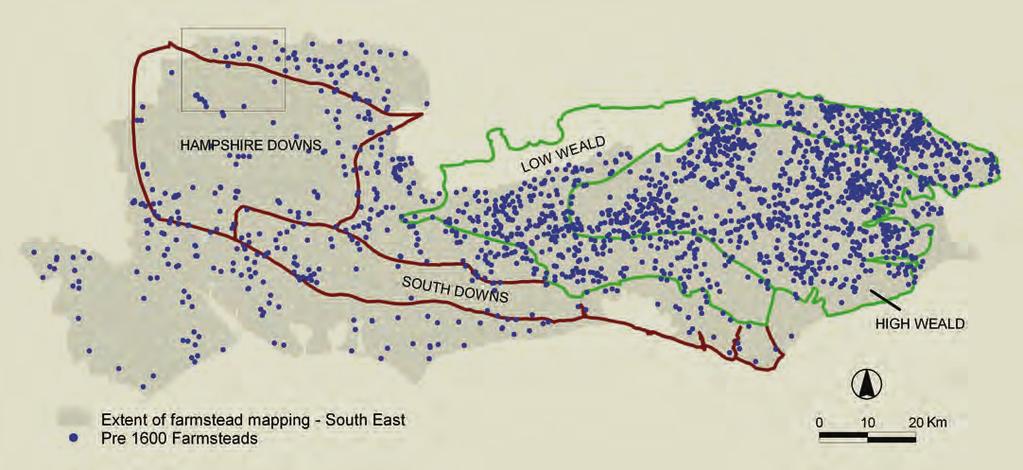
5 FARMSTEADS AND LANDSCAPE PROJECT Using historic Ordnance Survey (OS) maps the Farmsteads and Landscape Project has developed a Geographical Information System (GIS)-based methodology for the rapid quantification of the number, form and distribution of historic farmsteads, outfarms and isolated farm buildings. It provides baseline data for the distribution and pattern of historic farmsteads during the late 19th century. The project also quantified the survival of farmsteads by comparing the historic maps with modern OS maps. The methodology has been used to gather baseline and change data for three counties: East Sussex,West Sussex, Hampshire (discussed in this publication) and is currently being extended across the West Midlands. HISTORIC FARM BUILDING PHOTO SURVEY This work has analysed more than 16,000 photographs of listed working farm buildings taken during the first few years of the 21st century as part of the nation-wide Images of England (IoE) photographic survey. The structure and condition of each building was recorded along with any clearly visible change of use. The research provides statistically robust estimates of adaptive re-use at a range of spatial scales (National, Regional, National Character Area, local authority district and for Protected Areas). HISTORIC FARMSTEADS: CURRENT ROLE AND CONTEXT PROJECT Three linked sub-projects investigated the current use of historic-farm properties using micro-scale land-use and economic activity information. The resulting data were used to determine the number and distribution of historic-farm-building conversions at a range of spatial scales. In contrast to the Historic Farm Building Photo Survey, the work covered both listed and un-listed buildings. None of these projects are concerned with monitoring the condition, management or use of individual buildings or land holdings. Instead they are designed to provide a picture of change within this historic building stock as a whole, in order to inform policy and practice. MAPPING FARMSTEAD CHARACTER: QUANTIFYING THE NUMBER, DISTRIBUTION, CHARACTER AND CONDITION OF HISTORIC FARMSTEADS Key points The Farmsteads and Landscape Project has developed a rapid and cost-effective method of recording some of the key characteristics of historic farmsteads, outfarms and field barns. OS maps are used to identify key attributes including farmstead name, plan type, date and the degree of change experienced since the late 19th century. The mapping of all farmsteads existing in the late 19th century provides the basis for a consistent understanding of inherited farmstead character at a landscape scale. In particular, it demonstrates clear links between landscape character and the date, density and distributions of the plan-form of farmsteads. The mapping of farmsteads has greatly increased the ability of local authorities, utilising their Historic Environment Records (HERs), to deliver an informed understanding of the inherited character of the whole historic resource in its landscape context. Mapping degrees of change makes it possible to identify those landscapes with the most coherent groups of historic farmsteads, and in turn to target grant aid or inform planning policies and guidance. The Historic Farm Building Photo Survey incorporates baseline photographs of listed farm buildings taken as part of the national IoE project along with data from individual list descriptions and English Heritage s Listed Building System. By providing photographs of more than 16,000 farm buildings the Historic Farm Building Photo Survey is a robust tool for monitoring change in the condition of listed buildings capable of interrogation at the level of government region, National Character Area (NCA) and local authority district. 3


6 1 Farmsteads and Landscape Project study areas. English Heritage The mapping of plan types is helping us to understand locally distinctive patterns. The map shows the concentration in the High Weald and Low Weald of dispersed cluster plans. Crown Copyright All rights reserved English Heritage 2009 Licence number Living Buildings in a Living Landscape: Finding a Future for Traditional Farm Buildings recommends that future approaches to the re-use of historic farm buildings should avoid blanket off-the-peg solutions. Instead, they should be informed by an understanding of regional and local differences in the drivers for change, patterns of landscape and farmstead character, and the sensitivity of the latter to change (English Heritage et al, 2006). The guidance concluded that if future conservation and planning policy is to be effective then better information on the historic farm building stock is required. This information needs to reflect the whole of the historic farm building stock, not just those structures that are listed. It must also consider farmsteads as an integral part of landscape, in order that land-use planning, land and environmental management can take proper account of their overall historic value and their potential for future change. Local planning authorities are being exhorted through national planning guidance to recognise local distinctiveness and to reflect this in their evidence-based planning guidance and policy. The first step to improving the evidence base was to identify the size and distribution of the historicfarm-building stock and collect information on the key characteristics and spatial patterning of farmsteads using the framework offered by landscape. Landscape-scale approaches to the definition and mapping of areas and types have recently been developed for two purposes: to allow resources to be targeted to priority areas and features in the natural and historic environment and to inform the sustainable management of change everywhere. Distinct landscape character areas have been formally defined and mapped on a national basis through the NCAs ( ourwork/landscape/englands/character/areas). 4
7 These have been used to guide land management, including the targeting of grants under the Environmental Stewardship scheme, and spatial planning including the development of Landscape Character Assessment at county and local authority level. English Heritage and its county-based partners have also deepened our understanding and perceptions of how the present landscape reveals changes over time, and offers a legacy for future change, through the national Historic Landscape Character (HLC) Programme ( EVIDENCE FROM THE FARMSTEADS AND LANDSCAPE PROJECT UNDERSTANDING CHARACTER The first step in describing historic farmsteads in their landscape context was the publication in 2006 of a regional series of Preliminary Farmstead Character Statements ( Distribution maps indicated that considerable variation in the patterns of survival of listed farmstead buildings was closely linked to the depth, nature and intensity of agricultural and landscape change over time. English Heritage and Hampshire County Council then commissioned a pilot project to examine methodologies for assessing and describing the character of farmsteads at a local level. Carried out in Hampshire, this developed a methodology for describing farmstead character at a landscape scale (for national, county and local character areas), and recording historic farmsteads using GIS to create a point-data set, the key attribute of which was the farmstead plan the way the buildings of the farmstead are arranged. The pilot project developed a method for describing farmstead character and demonstrated that it was possible to identify and record the location, date and inherited character of historic farmsteads in relationship to landscape character and type, and the time-depth of the present landscape revealed by historic landscape characterisation. The methodology was subsequently used across the remainder of Hampshire followed by a study of the High Weald Area of Outstanding Natural Beauty (AONB), which straddles West Sussex, East Sussex and Kent. The mapping of farmsteads in Staffordshire has recently been completed, and is currently being carried out in Shropshire and Worcestershire. Mapping of the remaining counties of the West Midlands region is due to be completed by January 2010 with the support of the Regional Development Agency, Advantage West Midlands (Figure 1). UNDERSTANDING CHARACTER Living Buildings in a living landscape: Finding a future of Traditional Farm Buildings (English Heritage et al 2006) recommends that future strategies and approaches to re-use must align an understanding of character with sensitivity to and potential for change. This guidance is supported by a set of Preliminary Character Statements, consultative documents that represent an initial attempt to understand the farmsteads of each region in their national and landscape context. Further refinment is provided by a pilot website (see links on the HELM farmsteads page has been developed with funding from the Hampshire Rural Pathfinder Programme. It represents an initial stage in the development of a web-based framework for informing change and targeting resources, which should be applicable at a national scale and at the same time cheap to produce, amend and update. Guidance has been provided at a national, regional and local level, with headings that can be searched thematically or geographically, and a preliminary glossary of terms has also been provided. The Your Area section provides preliminary guidance for each of the 159 National Character Areas. These character-based tools are being developed in parallel with an assessment framework for application at an area- and site-based scale. Consideration is also being given to the best way of assisting the cost-effective delivery of planning guidance. METHODOLOGY The farmstead-mapping methodology utilises 2nd edition OS County Series mapping (c ) to identify farmstead and outfarm or field-barn sites. This 1:2500 survey provides a record of farmsteads close to the end of the final period of development of traditional farmstead forms and the general use of vernacular materials. The key attributes recorded were farmstead name (modern and historic name if different), plan type (see Figure 2), the date of the farmstead based on that of the oldest standing building (utilising listedbuilding data) and the degree of change experienced since the late 19th century (through comparison between the 2nd edition mapping and modern OS Mastermap depiction). A full description of the methodology is available at 5


8 3a 3b 3c 6
.")

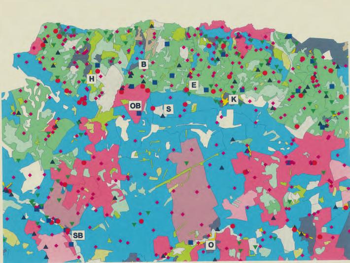
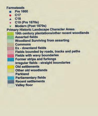
9 3a e Listed-building data shows that farmsteads retaining buildings from before 1600 are concentrated in areas of predominantly dispersed settlement that were anciently enclosed, in particular the High Weald and Low Weald but also other wood pasture landscapes in south-eastern of England (Figure 3a). Two detailed maps show farmsteads by date against historic landscape character (3b) and landscape types (3c). These extracts demonstrate the clear divide in farmstead date and density between the assarted landscapes of the clay lowlands of north Hampshire compared to the chalk of the Hampshire Downs to the south. They also show distinct patterns within the Hampshire Downs, with some areas being subject to piecemeal enclosure from the 15th to 17th centuries (fields with wavy boundaries on the historic landscape character map). 3d 3e Within these areas are farmsteads retaining buildings of at least 17th-century date; typically timberframed barns, some of which are aisled, stables and granaries with hipped roofs set in loose courtyard arrangements (Figure 3d). The large areas of later enclosure across the downs (historic landscape character Parliamentary fields and openarable-landscape type) have very few farmsteads that can be dated by the presence of listed buildings (Figure 3e brick and flint farmstead). This means that most of these farmsteads will be unrecorded in HERs. These farmsteads, however, also make an important contribution to the character of the landscape. Crown Copyright All rights reserved Hampshire CC Photographs Bob Edwards 1 This methodology allows the rapid and cost-effective production of an independent data set recording all farmstead sites present in the late 19th century, which can: identify the significant characteristics of farmsteads and their relationship with patterns of visual and inherited landscape character provide a baseline for mapping change and for extensive and targeted field survey aimed at deepening an understanding of the principal characteristics of farm-building types, including, form, construction materials, state of repair and conversion to other uses. MAPPING THE WHOLE RESOURCE All farmsteads contribute to the quality and local distinctiveness of the landscape, not just those groups of buildings that have been defined as being of special interest. The mapping of all farmsteads existing in the late 19th century provides the basis for a consistent understanding of inherited farmstead character at a landscape scale. In particular, it demonstrates clear links between landscape character and the date, density, distributions and the plan-form of farmsteads. The subsequent mapping of farmsteads has greatly increased the ability of local authorities, utilising their HERs, to deliver an informed understanding of the inherited character of the whole historic resource. Because the vast majority of historic farmsteads do not include listed buildings they would not otherwise benefit from specialist historic environment input at times when they come into the planning system. Across the areas mapped, to date 17,365 farmsteads and 4,151 outfarms and field barns have been recorded. Around one-third (31 per cent) of the farmsteads include one or more listed buildings. Although the sites of these farmsteads are likely to have been recorded in local authority HERs holding listed-building data, there is less probability of any useful record of the overall farmstead group to which they belong. The majority of the 11,931 sites that do not include a listed building are unlikely to have been recorded in the local HER. Notwithstanding their unlisted status, these farmsteads require an appropriate response when development proposals come forward, to ensure that their contribution to the landscape is carefully retained, enhanced or recorded. Mapping within the study areas in the south-east of England demonstrated a very high proportion of farmsteads retaining one or more buildings dating from before It also showed close correlation 7
10 between areas with coherent patterns of medieval fields and early farmsteads (see Figure 3). The character of the High Weald as a landscape of small irregular fields created through assarting the piecemeal clearance of woodland to create fields, largely completed by the 14th century is a major factor in its designation as an AONB. The fact that this landscape not only retains a high proportion of its medieval fields but its pattern of dispersed farmsteads with early buildings emphasises its considerable historic significance. The pilot project in north Hampshire highlighted the value of recording all farmsteads irrespective of designation. Analysis of the farmsteads data against the county landscape types and historic landscape characterisation showed that the open chalk landscapes of the Hampshire Downs had experienced considerable change in the 19th century (mostly through enclosure of former downland or common) and, typically, had a low concentration of farmsteads that included listed farm buildings. Assessment of the context of these farmsteads nevertheless identified them as making an important contribution to landscape character (Figure 3). Similarly, in areas characterised by small farmsteads (often associated with part-time farming or communing) few farm buildings have been statutorily listed or recorded in county HERs. The small buildings of such farms are often highly characteristic of their area and vulnerable to change and in many cases they occur in areas that are designated as National Parks or AONBs for their high landscape value (Figure 4). MAPPING FARMSTEAD TYPES The variety of farmstead types reflects their past requirements for working buildings, areas for storing and processing crops, places for managing and housing livestock and easy access to routes and tracks. Recording the spatial distribution of farmstead plan types shows how some are highly characteristic of particular landscapes. It also demonstrates that some types of plan have different sensitivity to and capacity for change. For example, in the High Weald and, to a lesser extent, the Low Weald dispersed plan types were identified as strongly characteristic (Figure 2). These farmsteads include types of building common to the wider area but whose dispersed character and frequent association with a local network of ancient routeways (many now public rights of way) mean that there is often public access through the heart of the farmstead. This provides a level of visibility to the buildings that contrasts strongly with inward-facing courtyard-plan farmsteads. In upland areas such as the Peak District, linear-plan farmsteads where the farmhouse is attached in-line with the working buildings are a strong characteristic of the landscape. In contrast, linear plans are almost entirely absent from the south-east of England. FARMSTEAD CHANGE The mapping of farmsteads provides an opportunity to record the amount of change that has occurred since the baseline 2nd edition OS survey of the late 19th century. Across the areas that have been mapped by the Farmsteads and Landscape Project to date, more than 77 per cent of farmsteads recorded from the 2nd edition maps retain some legible farmstead character (Figure 6). Whether still in agricultural use or with buildings converted to residential or commercial use, these farmsteads are likely to make a positive contribution to landscape character. Traditional farmsteads subject to the least change (EXT and ALT in Figure 6) are likely to make the greatest contribution to local distinctiveness. This is because they are most likely to have retained their varied styles, building materials and the way that they relate to the surrounding form and patterning of the landscapes within which they developed. In future, the continuing restructuring of farm holdings and infrastructure is likely to bring many working farms in this category into the planning system. Farmsteads and areas that have been subject to higher levels of change may also offer new opportunities for the enhancement of local landscape character, either through the appropriately designed conversion of existing buildings or, in some cases, the construction of new buildings that take the opportunities offered by local forms and idioms (Figure 5). Mapping degrees of change makes it possible to identify those landscapes with the most coherent groups of historic farmsteads, and in turn to target grant aid or inform planning policies and guidance. For example, farmsteads in parts of the Staffordshire Peak District show considerably less change than their counterparts in the NCAs that have so far been recorded in southeast England. This may be partly because the linear form of many farmsteads encourages the absorption of ancillary buildings into the main farmhouse. However, field survey has also shown that a high proportion of the medium and larger courtyard-plan farmsteads have retained their historic buildings in agricultural use. 8


11 4 A small earth-built cow house or stable in the New Forest NCA. The small buildings of commoners are both highly characteristic and vulnerable to loss. Bob Edwards 6 The buildings of this farmstead in the High Weald have all been converted to domestic use, but they can still be appreciated as part of its distinctive densely wooded historic landscape. Jan Holubecki 5 Farmstead survival by NCA. Data sorted by percentage of farmsteads within the two categories of least change. Comparison of historic and modern OS mapping allows assessment of the degree of change as measured by the loss of buildings within farmsteads. The table gives the statistics for farmstead change within the NCAs mapped to date. It shows that farmsteads within the NCAs of Staffordshire, and the upland part of the county in particular, tend to have been subject to lower levels of change than those of south-eastern England. While the landscapes and farmsteads of these upland areas often reflect relatively late enclosure or reorganisation of the landscape (and thus few listed farm buildings) the data indicate that relatively unaltered farmsteads, often still in agricultural use and set within their contemporary fields, contribute positively to the character of the landscape. Future management needs to recognise their value to the landscape. Source: Data derived from Farmstead and Landscape Project (courtesy of English Heritage, Hampshire County Council, West Sussex County Council, East Sussex County Council, High Weald AONB, Staffordshire County Council) EXT Farmstead is largely unaltered from late 19th century form ALT Some noticeable change but less than 50% loss of buildings ALTS Considerable change more than 50% loss of buildings HOUS Only the farmhouse survives -all working buildings have been lost DEM All buildings shown on late 19th century map have been lost but site remains a farmstead LOST The farmstead site has been completely lost, either through redevelopment to another use (housing etc) or total demolition and removal from the landscape CCA EXT ALT EXT+ALT ALTS HOUS DEM LOST DEM+LOST South West Peak White Peak Needwood *Potteries and Churnet Valley Shropshire, Cheshire and Staffordshire Plain South Downs Mid Severn Sandstone Plateau Trent Valley Washlands Cannock Chase and Cank Wood Low Weald High Weald Pevensey Levels New Forest Hampshire Downs Romney Marsh South Coast Plain South Hampshire Lowland Farmstead Survival by National Character Area. Data sorted by percentage of farmsteads within the two categories of least change. Green NCAs Staffordshire; Pink NCAs South East * Farmsteads within the Unitary Authority Area of Stoke-on-Trent not included in figures. 9

12 7 Outfarms and field barns were once a common feature of large parts of the landscapes of the south-east. Comparison of historic and modern OS maps shows that 70 per cent have been completely lost from the landscape since the late 19th century. Few outfarm complexes benefit from including listed buildings and their oftenisolated positions can restrict options for alternative uses. Their contribution to the understanding of the development and character of the landscape is not always recognised and few benefit from positive management. Crown Copyright. All rights reserved. East Sussex CC , 2009 West Sussex CC , 2009 Kent CC , 2009 Hampshire CC , Proportion of listed farm buildings showing structural failure by region. Source: Historic Farm Building Photo Survey data (courtesy of English Heritage) 9 Proportion of listed farm buildings showing structural failure by NCA. Source: Historic Farm Building Photo Survey data (courtesy of English Heritage) 10 Proportion of listed farm buildings showing structural failure by local authority district. Source: Historic Farm Building Photo Survey data (courtesy of English Heritage) 11 Visible change of use of listed farm buildings by region. Source: Historic Farm Building Photo Survey data (courtesy of English Heritage) This is in marked contrast to south-east England, where the amalgamation of holdings has resulted in the complete loss of many farmsteads from the landscape.the two areas with the highest levels of complete loss of farmsteads are both on parts of the south coast, which has been subject to intensive urban expansion. However, areas where traditional farmsteads continue to make an important contribution to landscape character, such as the High Weald, have experienced greater loss of farmsteads loss than the Peak District. One of the most striking observations of the farmstead-mapping project is the distribution and level of change to which outfarms and field barns have been subject. Although south-eastern England is not now noted for its field barns, these complexes were once a common feature of parts of the region (Figure 7). In Hampshire 75 per cent of outfarms and field barns have been lost since the end of the 19th century and 72 per cent in East Sussex. Few of the remaining buildings are listed but given the extent of loss an argument can be made for closer examination of their suitability for designation or targeted management through agri-environment schemes. The outputs from the Farmsteads and Landscape Project have a variety of important uses: developing and supporting land-use policy including Supplementary Planning Documents informing and assisting the strategies of Rural Development Agencies and local authorities with regard to the options for re-use of redundant farmstead buildings informing discussions on the sustainability of rural settlements assisting the targeting of the Higher Level Environmental Stewardship historic-building-repair option 8 GOVERNMENT REGION % DISREPAIR South West 7.2 South East 8.2 East of England 5.7 West Midlands 18.9 East Midlands 6.1 Yorkshire & the Humber 10.5 North East 13.5 North West 5.4 England 8.9 assisting landowners, managers and advisers with Farm Environment Plans and applications providing the context and understanding for planning and grant aid applications relating to individual farmsteads. 10
13 9 DISREPAIR: EVIDENCE FROM THE HISTORIC FARM BUILDING PHOTO SURVEY 0 The analysis of OS maps undertaken as part of the Farmsteads and Landscape Project can trace the survival and changing plan of farmsteads through time. However, it cannot tell us about the current structural condition of the surviving working farm buildings. The Historic Farm Building Photo Survey provides an indication of the condition of listed working farm buildings 1, with the focus being on individual buildings rather than farmstead groups. METHODOLOGY Between 2003 and 2007 English Heritage and (initially) the Countryside Agency commissioned the Countryside and Community Research Unit to undertake a series of desk-based photographic survey projects. The database resulting from these would in turn be used to produce a robust statistical analysis of the nature and condition of the listed working farm building resource at a national, regional and local level and to support its long-term monitoring Kilometres English Countryside Character Areas Percentage of farm buildings with visible structural failure 0.0 to 0.5% 0.5 to 5.0% 5.0 to 10.0% 10.0 to 15.0% 15.0 to 20.0% Above 20.0% Kilometres The database incorporates baseline photographs of listed farm buildings taken between 1999 and 2006 as part of the national Images of England project along with data from individual list descriptions and English Heritage s Listed Building System. Photographic analysis was undertaken to record the structural condition of each building along with any visible change of use. By providing photographs of more than 16,000 farm buildings the database is a robust tool for monitoring change in the condition of listed buildings and the frequency of their conversion over time, capable of interrogation at the level of government region, NCA and local authority district. English Local Authorities Percentage of farm buildings with visible structural failure 0.0 to 0.5% 0.5 to 5.0% 5.0 to 10.0% 10.0 to 15.0% 15.0 to 20.0% Above 20.0% 11 RESIDENTIAL South West 29.90% South East 32.50% East of England 27.80% West Midlands 27.10% East Midlands 30.60% Yorkshire & the Humber 35.40% North East 19.00% North West 26.60% England 29.70% OTHER 3.20% 5.70% 4.70% 3.00% 3.60% 2.70% 1.90% 2.50% 3.90% 1 These are farm buildings excluding farmhouses and other farm dwellings that are principal listed buildings (ie. buildings that are the subject of list entry, rather than buildings listed by virtue of curtilage association). NONE 66.80% 61.90% 67.60% 69.90% 65.80% 61.90% 79.10% 70.90% 66.40% 11
14 12 Proportion of listed-farm 13 Proportion of conversions building-conversions by NCA. Source: Historic Farm Building Photo Survey data (courtesy of English Heritage) of listed farm building by local authority district. Source: Historic Farm Building Photo Survey data (courtesy of English Heritage) EVIDENCE In 2001 there were 29,965 listed-building entries that probably contained working farm buildings. Just over half Kilometres At a national level just over 1 in 11 unconverted principle listed working farm buildings (8.9 per cent) showed obvious signs of structural failure based on roof and wall condition. The location of the farm building within the farmstead was an important influence on the level of disrepair. There is a tendency for the walls and roofs of isolated farm buildings to be less well maintained (9.5 per cent in disrepair) than those attached to farmhouses or other farm dwellings (5.4 per cent). English National Character Areas Percentage of farm buildings with visible adaptive re-use 0 to 10% 10 to 20% 20 to 30% 30 to 40% 40 to 50% Above 50% 13 English Local Authorities Percentage of farm buildings with visible adaptive re-use 0 to 10% 10 to 20% 20 to 30% 30 to 40% 40 to 50% Above 50% 12 these records (55 per cent) had a matching IoE photograph that clearly showed farm buildings. The figures presented in this publication are based on the analysis of 16,588 IoE photographs taken up to June 2006 (this supersedes the figures presented in Heritage Counts (2005), which were based on 9,271 photographs taken up to December 2004) Kilometres 200 More detailed analysis showed that at a regional level the West Midlands, North-East and Yorkshire and the Humber have a higher proportion of buildings with clearly visible structural failures than the national average (Figure 8). Buildings in National Parks show a rate of disrepair that is significantly lower than the national figure (4.6 per cent) but the difference between AONBs and the national picture was less marked (7.7 per cent). There are also clear variations in the condition of farmstead buildings when the data are analysed at NCA level, with particularly high rates of disrepair in the Welsh Marches, Arden, Nottinghamshire, Derbyshire and Yorkshire Coalfield, Manchester Pennine Fringe, Lincolnshire Vale, Wolds and Marches, South-East Northumberland and Tyne and Wear NCAs (Figure 9). At a local authority level there are concentrations of districts with high rates of disrepair in the Midlands bordering Wales, Cornwall, South Yorkshire and in the North-East (Figure 10).
15 THE ADAPTIVE RE-USE OF HISTORIC FARM BUILDINGS Key points The Historic Farm Building Photo Survey provides robust data on the adaptive re-use of listed farm buildings capable of interrogation at the level of government region, National Character Area and local authority district. The Historic Farmsteads: Current Role and Context Project has developed a range of rapid and cost-effective techniques to monitor the conversion of both listed and non-listed farm buildings to residential and other uses. Together these projects have provided remarkably consistent evidence about type and pattern of change with conversion to residential use being dominant in all areas, despite the existence of planning policies that favour conversion to non-residential uses. EVIDENCE FROM THE HISTORIC FARM BUILDING PHOTO SURVEY One-third (34 per cent) of listed working farm buildings have been visibly converted to non-agricultural uses and the majority of conversions are for residential use (87 per cent of conversions).working buildings attached to dwellings (44 per cent) are more likely to undergo conversion than those that are isolated (31 per cent). Working buildings were significantly less likely to be converted within National Parks (22 per cent) while AONB designation made no apparent difference to the level of conversion (34 per cent). At a regional level the South-East and Yorkshire and the Humber have experienced the highest level of conversion (38 per cent in each region), while in the North-East the recorded level of conversion falls to 21 per cent (Figure 11). The frequency of conversion also varies considerably between NCAs (Figure 12). NCAs with high levels of conversion (more than 50 per cent) include Carnmenellis, Hensbarrow, the High Weald, Forest of Dean and Lower Wye, Mid Severn Sandstone Plateau, Leicestershire and South Derbyshire Coalfield and Yorkshire Southern Pennine Fringe. When the data are analysed by local authority area (Figure 13), the recorded level of conversion is seen to exceed 50 per cent in 12 per cent of districts. For example, 85 out of 134 entries for Maidstone (63 per cent) show clearly visible signs of adaptive re-use (of which 80 were residential conversions). A further 21 per cent of districts have conversion levels of between 40 and 50 per cent. WAYS OF RESEARCHING THE CURRENT USE OF HISTORIC FARMSTEADS The current social and economic role of historic farmsteads can be determined through analysis of a series of publicly available data sources: computational interpretation of business names (included on all non-residential addresses in the Royal Mail Postcode Address File) to infer the nature of economic activity (including standard industrial classification) computational matching of occupier names with company names from a database of machine-readable company accounts (for substantial businesses with locations), providing further evidence of the nature of activity automated searches of internet sources, such as business directories, to derive information relating to particular properties and interpretation of retrieved material. The entry point for such searching tends to be present-day postal addresses and so this body of work also entails the use of related methods for matching postal addresses with historic-property names and, where appropriate, entries on the statutory list. EVIDENCE FROM THE HISTORIC FARMSTEADS: CURRENT ROLE AND CONTEXT PROJECT English Heritage and its partners have recently supported innovative work to examine the economic and social role of historic farmsteads and their buildings. A key part of this involves the use of existing computer data sets to develop cost-effective techniques for monitoring the conversion of farm buildings to residential and other uses. In particular, emphasis has been given to improving the evidence base for the conversion of non-listed buildings as a means of supplementing the evidence for listed buildings provided by the Historic Farm Building Photo Survey. Information can also be collected and analysed at the strategic level about the different types of use that converted farm buildings are put to and the socio-economic characteristics of their occupiers.this section draws on the findings from the following three linked sub-projects, each of which exploits natural language programming in tandem with GIS functionality to interpret a range of socio-economic data derived from publicly available Census, postal and internet sources: 13


16 Countryside Quality Counts. An assessment of the extent of barn property conversion across the country based on work undertaken as part of the Countryside Quality Counts project supported by Natural England, English Heritage and Defra ( landusechange.html) Historic Farm Complexes in Current Socio-Economic Context:A Pilot Study. An assessment for English Heritage of the current use and social role of historic farm buildings in an area stretching through Hampshire to East Sussex Historic Farm Complexes in Current Socio-Economic Context: High Weald. A more detailed analysis of the current economic use of historic-farm property for the High Weald AONB, expanding on the English Heritage study ( contexthistoricfarmsteads.pdf). BARN CONVERSION Desk-based computational approaches allow rapid assessment of the pace at which agricultural buildings are being converted to other uses and allow a rapid and cost-effective method of ascertaining their current use. The Countryside Quality Counts project used this approach to analyse Royal Mail s Postcode Address File (PAF), a comprehensive listing of postal addresses developed for mail-delivery purposes. Farm buildings in agricultural use or that have been abandoned do not have postal addresses. On conversion to provide residential or business accommodation, however, they do. Such converted property is frequently dubbed Barn, and the number of properties so named can stand as a proxy measure for the stock of converted barns, whether listed or unlisted. Barns are often the largest buildings on the farmstead and are generally the most suited, due to their overall proportions, for adaptive re-use that results in the acquisition of a postal address. Using a computational grammar, property names such as The Barn, The Old Barn, Highstones Head Barn, are tracked by this indicator, while names such as Common Barn Farm, Barn Cottage or Barn Again Bistro are excluded. Buildings identified by this indicator might be described as (postally) addressable barns (Figure 14). Clearly, use of this procedure will not identify all farm-building conversions, as not all conversions have names of this form. However, increases in the stock of addressable barns over time provide evidence of the pace of conversion affecting the 14

. All but 3.")

17 entire historic resource. This can be tested by field survey and matching to the results of the Historic Farm Building Photo Survey. RESULTS Work for the Countryside Quality Counts project, using the increase in number of addressable barns as a proxy, suggested that in rural areas the stock of converted barns expanded by 39 per cent between 1998 and 2003 (Figure 15). Moreover, between 2003 and 2008, this vigorous pace of conversion activity appears to have been maintained. By the end of 2008, across England as a whole, there were 28,700 addressable-barn properties, more than double the corresponding figure ten years previously (13,900). All but 3.3 per cent were in residential use. In principle, variation in the extent of the implied conversion activity from place to place might be expected to reflect the scale and type of the historic resource on the one hand and local housing-market conditions on the other. It appears, however, that over the last decade the credit-fuelled housing boom provided conditions particularly favourable to conversion across most of England.Variation in levels of conversion activity appears simply to reflect variation in the inherited character and adaptability of the historic resource itself. The amount of conversion indicated by the proxy is broadly in step with the geographical distribution of listed barns. In particular, it highlights the high numbers of addressable barn properties in areas of traditional wood-pasture (Figure 16). The highest densities are found in the Pennines (eg South Pennines and Yorkshire Southern Pennine Fringe NCAs extending to the Morecambe Coast and Lune Estuary NCA). Other traditional wood-pasture areas with high densities of addressable barns include East Anglia (South Suffolk and North Essex, and South Norfolk and High Suffolk NCAs) and the Weald (High Weald, Low Weald and Wealden Greensand NCAs). Figure 15 shows that conversion activity since 1998 has simply intensified the pattern of geographic differentiation (at least at NCA level). Divergences are found, however, between the geographical distributions of addressable-barn conversions and those of the overall stock of listed barns, as evident in Figure 16. For example, numbers of addressable-barn properties in Hertfordshire and Essex are smaller than might be predicted simply on the basis of the total population of listed barns. Elsewhere, problems of poor accessibility may explain relatively low levels of conversion in parts of Herefordshire (eg Black Mountains and Golden 14 An addressable barn: Grade II-listed Ashley Manor Barn (Cotswold NCA) in 2006 after conversion. Peter Bibby 15 National distribution of addressable barns Peter Bibby 16 Divergence between addressable barns and listed barns. Numbers of addressable barns in Hertfordshire and Essex are smaller than might be expected simply on the basis of the numbers of listed barns. Problems of poor accessibility may explain relatively low levels of conversion in parts of Herefordshire. Where numbers of addressable barns are substantially higher than might be expected, such as Avon and much of 17a 17b 18 Cornwall, this appears to reflect both market pressure and the character of the stock itself. Peter Bibby 17a+b An unlisted barn adjoining the Grade II-listed farmhouse at Fir Trees Farm, Goosnargh (Bowland Fringe and Pendle Hill NCA) in 1999 before conversion (17a Peter Bibby) afterwards in 2008 (17b). Mr David Blaylock, courtesy of Images of England 18 Current role of historic-farm property: High Weald AONB. Within the High Weald AONB there is a significant amount of home-based business activity and professional home-working associated with historic farm property. Peter Bibby 15
National Character Area 70 Melbourne Parklands
 Summary The are a landscape of rolling farmland, parkland and woodland on the northern flanks of the ridge between Burton upon Trent and Swadlincote. The land slopes down to the River Trent, which borders
LANDSCAPE CHARACTER ASSESSMENT
 THE COUNTY DURHAM LANDSCAPE CHARACTER ASSESSMENT FOREWORD The landscape of County Durham is one of great contrast and diversity. From the North Pennines in the west to the Durham Coast in the east it contains
Arden. National Character Area 97. Summary
 Summary comprises farmland and former wood-pasture lying to the south and east of Birmingham, including part of the West Midlands conurbation. Traditionally regarded as the land lying between the River
Cotswolds AONB Landscape Strategy and Guidelines. June 2016
 Cotswolds AONB Landscape Strategy and Guidelines June 2016 Cotswolds AONB Landscape Strategy and Guidelines Introduction The evolution of the landscape of the Cotswolds AONB is a result of the interaction
HERITAGE COUNTS 2017 East of England
 HERITAGE COUNTS 2017 East of England Introduction Heritage Counts 2017 is the sixteenth annual survey of the state of England s historic environment. This Regional Report is prepared by Historic England
Oxford Green Belt Study. Summary of Final Report Prepared by LUC October 2015
 Oxford Green Belt Study Summary of Final Report Prepared by LUC October 2015 Project Title: Oxford Green Belt Study Client: Oxfordshire County Council Version Date Version Details Prepared by Checked by
GUILDFORD BOROUGH GREEN BELT AND COUNTRYSIDE STUDY
 GUILDFORD BOROUGH GREEN BELT AND COUNTRYSIDE STUDY Volume II - Addendum On behalf of Guildford Borough Council PPG Ref : BNL.0287 April 2014 COPYRIGHT The conents of this document must not be copied or
Suffolk Coast & Heaths AONB Boundary Variation Project
 Suffolk Coast & Heaths AONB Boundary Variation Project 24 September 2014, David Vose, Jonathan Dix Background The project to formally consider a variation to the boundary of the SC&H AONB boundary www.naturalengland.org.uk
9 Archaeology & Cultural Heritage
 High Clachaig Wind Farm Scoping Report Page 56 9 Archaeology & Cultural Heritage 9.1 Introduction Cultural heritage in this context means the above- and below-ground archaeological resources, built heritage,
LANDMAP Methodology Overview
 LANDMAP Methodology Overview June 2017 Jill Bullen, Senior Landscape Specialist jill.bullen@cyfoethnaturiolcymru.gov.uk 0300 065 4706 (Please note this is an information document and not a training presentation)
Historic England Advice Report 26 August 2016
 Case Name: Kingsland Castle Case Number: 1435892 Background Historic England has been asked to review the scheduling for Kingsland Castle. The land on which the monument lies is understood to be for sale.
TOPIC PAPER 2: Links to other sustainability tools
 TOPIC PAPER 2: INTRODUCTION 1.1 Landscape Character Assessment can inform a range of other sustainability tools and methodologies. Equally these other tools may assist in reaching decisions concerning
Settlement Boundaries Methodology North Northumberland Coast Neighbourhood Plan (August 2016)
") Introduction This background paper sets out a methodology for the definition of settlement boundaries in the North Northumberland Coast Neighbourhood Plan. The neighbourhood plan is planning positively
Introduction This background paper sets out a methodology for the definition of settlement boundaries in the North Northumberland Coast Neighbourhood Plan. The neighbourhood plan is planning positively
Suffolk Coastal Local Plan Review Issues and Options, August 2017, Public Consultation
 Suffolk Coastal Local Plan Review Issues and Options, August 2017, Public Consultation Having reviewed the issues and options documents, the Society has made the following response: Part 1 - Strategic
Examination of South Cambridgeshire Local Plan
 Matter SC6A - Policy SS/5 Waterbeach New Town Historic England( formerly English Heritage) 874 Rep Nos 59748, 60250, 60253 Examination of South Cambridgeshire Local Plan Historic England, Hearing Statement
Archaeology and Planning in Greater London. A Charter for the Greater London Archaeology Advisory Service
 Archaeology and Planning in Greater London A Charter for the Greater London Archaeology Advisory Service THE PURPOSE OF THE CHARTER This Charter sets out how English Heritage will provide archaeological
Strip Enclosure. Summary of Dominant Character
 Strip Enclosure Summary of Dominant Character This zone is characterised by long thin curving fields, sometimes all running in the same direction and sometimes forming a patchwork pattern across the landscape.
A Research Framework for the Archaeology of Wales Version 01, Final Paper Neolithic and Earlier Bronze Age
 NEOLITHIC AND EARLIER BRONZE AGE Introduction The introduction of farming around 4000 BC had a dramatic impact on the landscape of Wales and fundamentally changed they ways in which people lived and interacted.
About 10% of the Borough's population lives in the seven rural parishes. Population figures from the 1991 census are given below:-
 8. THE DISTRICT VILLAGES 8.1 Population About 10% of the Borough's population lives in the seven rural parishes. Population figures from the 1991 census are given below:- Village No. of Persons Cottingham
Site Assessment Technical Document Appendix A: Glossary
 Central Bedfordshire Council www.centralbedfordshire.gov.uk Site Assessment Technical Document Appendix A: Glossary July 2017 1.1.11-1 - ii Appendix A: Glossary Term Agricultural Land Classification AONB
MAKING SENSE OF PLACE
 MAKING SENSE OF PLACE Landscape Character Assessment Summary Guidance for England and Scotland MAKING SENSE OF PLACE People can welcome development if it is well designed and contributes to quality of
Wind energy development in the South Pennines landscape
 Wind energy development in the South Pennines landscape Programme for today Background Policy context South Pennines landscape Impacts of wind energy development The South Pennines Wind Energy Landscape
Environmental and Landscape Mapping
 Environmental and Landscape Mapping In support of the Calveley Neighbourhood Plan November 2016 Project Name and Number: Calveley Neighbourhood Plan 16-025 Document Name and Revision: Environmental and
INCREMENTAL CHANGE AREA REVIEW March 2015 Page 1
 INCREMENTAL CHANGE AREA REVIEW March 2015 Page 1 Table of Contents Introduction... 3 Background to Review... 3 Comparison of the Schedules to the General Residential Zone... 7 Methodology... 7 Policy Context...
Archaeological Evaluation and Assessment of Land at Kent Cottage, 19 Chapel Street, Hythe, Kent
 Archaeological Evaluation and Assessment of Land at Kent Cottage, 19 Chapel Street, Hythe, Kent Planning Application Y13/0463/SH Date of Report: 29/04/2015 Report for Marc Carney SWAT. ARCHAEOLOGY Swale
Assessing the Significance of the key characteristics of Historic Landscape Character Areas: a Discussion Paper
 Assessing the Significance of the key characteristics of Historic Landscape Character Areas: a Discussion Paper Background The 11 distinct Historic Landscape Types in the East Devon AONB have been used
Plaistow and Ifold Neighbourhood Plan Pre-Submission Consultation Draft
 Mrs Beverley Weddell Clerk to Plaistow And Ifold Parish Council Lock House Lodge Knightons Lane Dunsfold, GU8 4NU. Dear Mrs Weddell, Our ref: Your ref: Telephone Fax HD/P5402/ 01483 252040 18 th October
Countryside Character Volume 1: North East. The character of England s natural and man-made landscape
 Countryside Character Volume 1: North East The character of England s natural and man-made landscape BLANK PAGE Contents page Chairman s Foreword 4 Introduction 5 The character of England 5 The Countryside
Landscape values, people and change
 Landscape values, people and change Chris Bolton, Principal Specialist, Landscape Europarc Conference, Killarney 1 st October 2014 Topics ELC, CBD, Ecosystem services - Integration Natural and Social science
Archaeological Investigation in advance of Development at 2 Palace Cottages, Charing Palace, Charing, Kent
 Archaeological Investigation in advance of Development at 2 Palace Cottages, Charing Palace, Charing, Kent Site Code CHAR-EV-14 NGR 95412 49439 Date of Report 18/12/2014 Swale and Thames Archaeological
ENVIRONMENTAL AND LANDSCAPE MAPPING
 APPENDIX IV : Environmental and Landscape Mapping ENVIRONMENTAL AND LANDSCAPE MAPPING Calveley Neighbourhood Plan November 2016 ENVIRONMENTAL AND LANDSCAPE MAPPING Calveley Neighbourhood Plan Calveley
building with nature - a new benchmark for green infrastructure
 building with nature - a new benchmark for green infrastructure Danielle Sinnett, Gemma Jerome, Sarah Burgess, Nick Smith and Roger Mortlock outline the aims, development and proposed operation of Building
Landscape and Heritage A Park landscape that embraces the physical, cultural and social heritage of the area
 80 Park Development Framework Our Aim for Landscape and Heritage A Park landscape that embraces the physical, cultural and social heritage of the area Why do we think it is important? The landscapes of
LANDSCAPES FOR EVERYONE: CREATING A BETTER FUTURE. A shared vision of why we must treasure our landscapes and how Government can help
 LANDSCAPES FOR EVERYONE: CREATING A BETTER FUTURE A shared vision of why we must treasure our landscapes and how Government can help BRITAIN S DIVERSE LANDSCAPES NEED CHAMPIONS A consortium of national
3. Neighbourhood Plans and Strategic Environmental Assessment
 1. Introduction This report sets out a draft Screening Determination for the Preston Parish Council s Neighbourhood Plan and has been prepared by rth Hertfordshire District Council. The purpose of the
Volume 1 EXTRACT Third Edition March 2016 Wyvern Heritage and Landscape Consultancy
 Historic Landscape Character Areas and their special qualities and features of significance Volume 1 EXTRACT Third Edition March 2016 Wyvern Heritage and Landscape Consultancy Emma Rouse, Wyvern Heritage
Call for Proposals. Heritage, natural capital and ecosystem services: case studies. Project No: Date of Issue: Tuesday 14 th November 2017
 Call for Proposals Heritage, natural capital and ecosystem services: case studies Project No: 7705 Date of Issue: Tuesday 14 th November 2017 Summary Historic England is seeking expressions of interest
Could protected landscapes have a leading role to play in the sustainable management of natural resources?
 Rural Economy and Land Use Programme Centre for Rural Economy School of Agriculture, Food and Rural Development Newcastle University Newcastle upon Tyne NE1 7RU Telephone: 0191 222 6903 Fax: 0191 222 5411
WELLINGTON HOSPITAL DESIGN GUIDE TABLE OF CONTENTS
 WELLINGTON HOSPITAL DESIGN GUIDE TABLE OF CONTENTS 1.0 Introduction Page 2 The Place of Wellington Hospital 2 The Future of the Hospital 2 2.0 The Intention of the Design Guide 3 3.0 Analysis 4 General
CITY CLERK. Parkland Acquisition Strategic Directions Report (All Wards)
") CITY CLERK Clause embodied in Report No. 10 of the, as adopted by the Council of the City of Toronto at its meeting held on November 6, 7 and 8, 2001. 10 Parkland Acquisition Strategic Directions Report
CITY CLERK Clause embodied in Report No. 10 of the, as adopted by the Council of the City of Toronto at its meeting held on November 6, 7 and 8, 2001. 10 Parkland Acquisition Strategic Directions Report
Lower Sensitivity. VS Classification Level 2: Exposed Upland/Plateau
 S05 Y Moelwynion Reproduced from the Ordnance Survey map with the permission of Ordnance Survey on behalf of the Controller of Her Majesty s Stationery Office, Crown copyright Licence No. 100023387 Location
Newcourt Masterplan. November Exeter Local Development Framework
 Newcourt Masterplan November 2010 Exeter Local Development Framework Background The Exeter Core Strategy Proposed Submission sets out the vision, objectives and strategy for the development of Exeter up
Wildlife and Planning Guidance: Neighbourhood Plans
 Wildlife and Planning Guidance: Neighbourhood Plans This Leaflet is one of a series of 4 Wildlife and Planning Guidance Leaflets and is intended to provide useful information to assist you to campaign
2014/0590 Reg Date 26/06/2014 Chobham
 2014/0590 Reg Date 26/06/2014 Chobham LOCATION: PROPOSAL: TYPE: APPLICANT: OFFICER: ASCOT PARK POLO CLUB, WESTCROFT PARK FARM, WINDLESHAM ROAD, CHOBHAM, WOKING, GU24 8SN Erection of a two storey detached
Variation No 1: Dundalk & Environs Development Plan Core Strategy
 Variation No 1: Dundalk & Environs Development Plan 2009-2015 Core Strategy Adopted on 29 th August 2011 CONTENTS Page Section 1 1.0 Synopsis 1 1.1 Background Document 1 1.2 Variation of Dundalk and Environs
The European Landscape Convention The English Heritage Action Plan for Implementation
 The European Landscape Convention The English Heritage Action Plan for Implementation A C E F H I B D G BACKGROUND TO THE ACTION PLAN The Council of Europe s European Landscape Convention (the Florence
Chalk, Cherries and Chairs Central Chilterns Landscape Partnership Scheme LANDSCAPE PARTNERSHIP DEVELOPMENT OFFICER JOB INFORMATION PACK
 Chalk, Cherries and Chairs Central Chilterns Landscape Partnership Scheme LANDSCAPE PARTNERSHIP DEVELOPMENT OFFICER JOB INFORMATION PACK How to apply Please complete our application form, together with
Designations protecting the historic designed landscape
 Historic Landscape Project Designations protecting the historic designed landscape A. Key national designations affecting the historic environment: 1. Listed buildings 2. Scheduled Monuments (generally
Landscape and Heritage
 86 Park Development Framework Our Aim for A Park landscape that embraces the physical, cultural and social heritage of the area Why do we think it is important? The landscape provides a setting for every
WINCHESTER TOWN 3.1 LOCATION, CHARACTERISTICS & SETTING
 WINCHESTER TOWN 3.1 LOCATION, CHARACTERISTICS & SETTING 3.1.1 The area referred to by the City Council, as Winchester Town, consists of the Winchester Wards plus the adjoining built up areas of Badger
To secure a Green Belt around Cambridge whose boundaries are clearly defined and which will endure for the plan period and beyond.
 4. GREEN BELT OBJECTIVES GB/a GB/b GB/c GB/d To secure a Green Belt around Cambridge whose boundaries are clearly defined and which will endure for the plan period and beyond. To maintain the purposes
Useful Studio 1st Floor, The Clove Building 4 Maguire Street, Butler s Wharf London SE1 2NQ
 Ms M Barlow Useful Studio 1st Floor, The Clove Building 4 Maguire Street, Butler s Wharf London SE1 2NQ Our ref: PL00049085 By email: michelle.b@usefulstudio.co.uk 12 th December 2016 Dear Ms Barlow, Re:
REVIEW AND EVALUATION OF HERITAGE COASTS IN ENGLAND Executive Summary
 REVIEW AND EVALUATION OF HERITAGE COASTS IN ENGLAND Executive Summary Report to The Countryside Agency by Land Use Consultants July 2006 EXECUTIVE SUMMARY This paper evaluates the 32 Heritage Coasts defined
Draft Hailey Neighbourhood Plan
 Persimmon Homes (Wessex) Draft Hailey Neighbourhood Plan Representations to West Oxfordshire District Council s Regulation 16 Consultation December 2018 2 Copyright 2018 Persimmon Homes Ltd. All rights
UNCLASSIFIED. Risk of Flooding from Reservoirs - Severn River Basin District
 UNCLASSIFIED Flood Risk Maps Risk of Flooding from Reservoirs - Severn Why have we produced these maps what can they be used for? Under the Flood Risk Regulations Natural Resources Wales have worked in
Countryside Character Volume 4: East Midlands. The character of England s natural and man-made landscape
 Countryside Character Volume 4: East Midlands The character of England s natural and man-made landscape Contents page Chairman s Foreword 4 Introduction 5 The character of England 5 The Countryside Agency
Heritage Action Zone. Explanatory Notes and Guidance
 Heritage Action Zone Explanatory Notes and Guidance Contents What is a Heritage Action Zone?...2 What support can Historic England offer to a Heritage Action Zone?...2 What could a Heritage Action Zone
12 TH ANNUAL CHILTERNS AONB PLANNING CONFERENCE ENGLISH HERITAGE: HISTORIC ENVIRONMENT GOOD PRACTICE ADVICE
 12 TH ANNUAL CHILTERNS AONB PLANNING CONFERENCE ENGLISH HERITAGE: HISTORIC ENVIRONMENT GOOD PRACTICE ADVICE MARTIN SMALL HISTORIC ENVIRONMENT PLANNING ADVISER ENGLISH HERITAGE Policy ENGLISH HERITAGE GOOD
PLANNING COMMITTEE DATE: 07/09/2015 REPORT OF THE SENIOR MANAGER PLANNING AND ENVIRONMENT SERVICE CAERNARFON. Number: 4
 Number: 4 Application Number: C15/0034/37/LL Date Registered: 21/05/2015 Application Type: Full - Planning Community: Llanaelhaearn Ward: Llanaelhaearn Proposal: Location: Summary of the Recommendation:
Lower Sensitivity. VS Classification Level 2: Exposed Upland/Plateau
 S04 Moel Hebog Reproduced from the Ordnance Survey map with the permission of Ordnance Survey on behalf of the Controller of Her Majesty s Stationery Office, Crown copyright Licence No. 100023387 Location
APP/G1630/W/15/
 Appeal Decision Site visit made on 20 October 2015 by William Fieldhouse BA (Hons) MA MRTPI an Inspector appointed by the Secretary of State for Communities and Local Government Decision date: 20 November
YMCA Erdington (Phase 2), 300 Reservoir Road, Erdington, Birmingham, B23 6DB
, 300 Reservoir Road, Erdington, Birmingham, B23 6DB") Committee Date: 13/06/2013 Application Number: 2013/03011/PA Accepted: 30/04/2013 Application Type: Full Planning Target Date: 30/07/2013 Ward: Stockland Green YMCA Erdington (Phase 2), 300 Reservoir Road,
Committee Date: 13/06/2013 Application Number: 2013/03011/PA Accepted: 30/04/2013 Application Type: Full Planning Target Date: 30/07/2013 Ward: Stockland Green YMCA Erdington (Phase 2), 300 Reservoir Road,
The Prehistoric Landscape Coaxial Field Systems
 The Prehistoric Landscape We know that much of Cornwall was densely populated in prehistory but that most of the fields laid out during this time were reorganised and overlain by medieval and later field
Late 20 th Century Municipal Suburbs
 Late 20 th Century Municipal Suburbs Summary of Dominant Character This zone represents suburban areas built by municipal authorities since 1960. There is often significant divergence between the plan
Ward: West Wittering. Proposal Change of use from public highway pavement to residential garden use.
 Parish: West Wittering Ward: West Wittering WW/17/03295/FUL Proposal Change of use from public highway pavement to residential garden use. Site Izora 1 Watersedge Gardens West Wittering PO20 8RA Map Ref
Parish of Repton NEIGHBOURHOOD DEVELOPMENT PLAN
 Parish of Repton NEIGHBOURHOOD DEVELOPMENT PLAN BASIC CONDITIONS STATEMENT December 2018 CEF 4 Legal Requirements This statement has been produced by the NDP Working Group on behalf of Repton Parish Council
PPS5: Planning for the Historic Environment
 Heritage at the Heart of the Planning System Heritage Protection Reform Newsletter SPRING 2010 PPS5: Planning for the Historic Environment >> English Heritage welcomes the new Planning Policy Statement
TIDAPA Structure Plan
 TIDAPA Structure Plan Prepared by Tract Consultants 28 MARCH 2017 0217-0074 Table of Contents 01 STRATEGIC CONTEXT Executive Summary Regional Context Page 3 Page 4 02 LOCAL CONTEXT Aerial Photograph Local
Appendix 1 Structure plan guidelines
 Appendix 1 Structure plan guidelines This appendix forms part of the regional policy statement [rps]. 1.1. Introduction Structure plans are an important method for establishing the pattern of land use
WILMCOTE NEIGHBOURHOOD PLAN
 WILMCOTE NEIGHBOURHOOD PLAN 1. Introduction. 1.1 David Holmes Planning Ltd has been instructed to advise Wilmcote Parish Council, who wish to prepare a Neighbourhood Plan. In particular we are asked to
Babergh and Mid Suffolk Joint Draft Local Plan Consultation, August 2017, Public Consultation
 Babergh and Mid Suffolk Joint Draft Local Plan Consultation, August 2017, Public Consultation Having reviewed the documents, the Society has made the following response: Housing Delivery Q 7. Do you agree
Local Development Scheme
 Local Development Scheme 2012 2016 The Local Development Scheme (LDS) is a project plan that outlines how and when the Authority will update its planning policies and other associated documents. It ensures
UTT/17/2075/FUL - (BERDEN) (Referred to Committee by Councillor Janice Loughlin. Reason: In the Public Interest)
 (Referred to Committee by Councillor Janice Loughlin. Reason: In the Public Interest)") UTT/17/2075/FUL - (BERDEN) (Referred to Committee by Councillor Janice Loughlin. Reason: In the Public Interest) PROPOSAL: LOCATION: APPLICANT: Amendments to the design of a scheme for a 49.99MW battery
UTT/17/2075/FUL - (BERDEN) (Referred to Committee by Councillor Janice Loughlin. Reason: In the Public Interest) PROPOSAL: LOCATION: APPLICANT: Amendments to the design of a scheme for a 49.99MW battery
LONGDEN VILLAGE DEVELOPMENT STATEMENT
 LONGDEN VILLAGE DEVELOPMENT STATEMENT 2017-2027 1 Longden Development Statement 2017-2027 15/01/18 1. Background 1.1 Longden Village Longden village is a very rural and traditional community first mentioned
Higher Uppacott: A Dartmoor Longhouse
 DETAILED PROJECT PLAN HLF Programme Area Area Programme Title Main Area (tick one box only) A Conserving or restoring the built and natural features that create the historic landscape character. B Increasing
S18 Mynyddoedd Yr Aran
 S18 Mynyddoedd Yr Aran Reproduced from the Ordnance Survey map with the permission of Ordnance Survey on behalf of the Controller of Her Majesty s Stationery Office, Crown copyright Licence No. 100023387
SPG 1. * the northern and western sections which are open fields used for pasture and grazing;
 SPG 1 1.0 INTRODUCTION This development brief is based on the allocation of the Priors Hall site for employment and countryside recreational purposes in the Corby Borough Local Plan. The brief is intended
Case Officer: Sarah Kay File No: CHE/14/00515/REM Tel. No: (01246) Plot No: 2/6132 Ctte Date: 15 th September 2014 ITEM 1
 Plot No: 2/6132 Ctte Date: 15 th September 2014 ITEM 1") Case Officer: Sarah Kay File No: CHE/14/00515/REM Tel. No: (01246) 345786 Plot No: 2/6132 Ctte Date: 15 th September 2014 ITEM 1 APPROVAL OF RESERVED MATTERS FROM APPLICATION CHE/12/00234/OUT (1) LAYOUT,
Case Officer: Sarah Kay File No: CHE/14/00515/REM Tel. No: (01246) 345786 Plot No: 2/6132 Ctte Date: 15 th September 2014 ITEM 1 APPROVAL OF RESERVED MATTERS FROM APPLICATION CHE/12/00234/OUT (1) LAYOUT,
Ipswich Issues and Options for the Ipswich Local Plan Review, August 2017, Public Consultation
 Ipswich Issues and Options for the Ipswich Local Plan Review, August 2017, Public Consultation Having reviewed the issues and options documents, the Society has made the following response: Part 1 Strategic
SHORELINE, FLOOD AND COASTAL DEFENCE MANAGEMENT PLANS
 These plans may provide opportunities as well as concern for recreational boating. They are currently being revised and consulted on. This document explains how we can engage in the process. Shoreline,
Interim Advice Note 76 / 06 ASSESSMENT PART 1 AIMS AND OBJECTIVES OF ENVIRONMENTAL ASSESSMENT. Contents
 Interim Advice Note 76 / 06 VOLUME 11 SECTION 1: ENVIRONMENTAL ASSESSMENT INTRODUCTION PART 1 AIMS AND OBJECTIVES OF ENVIRONMENTAL ASSESSMENT Contents 1. Introduction and Application 2. Aims and Objectives
DESIGN AND MANAGEMENT PART 3 HA 57/92 NEW ROADS INTEGRATION WITH RURAL LANDSCAPES SUMMARY
 DESIGN MANUAL FOR ROADS AND BRIDGES VOLUME 10 SECTION 1 ENVIRONMENTAL DESIGN AND MANAGEMENT NEW ROADS PART 3 HA 57/92 NEW ROADS INTEGRATION WITH RURAL LANDSCAPES SUMMARY This Advice Note gives guidance
Archaeological evaluation on land at Mersea Fleet Way, Chelmer Road, Braintree, Essex, CM7 3PZ
 Archaeological evaluation on land at Mersea Fleet Way, Chelmer Road, Braintree, Essex, CM7 3PZ by Laura Pooley figures by Ben Holloway and Emma Holloway fieldwork by Ben Holloway, Robin Mathieson, Nigel
Proposed Retirement Village Cole Green Way, Hertford. Archaeology Statement
 RETIREMENT LIVING MADE BETTER Proposed Retirement Village Cole Green Way, Hertford Archaeology Statement Woodlands Retirement Village RETIREMENT LIVING MADE BETTER Retirement Living Made Better Archaeology
3 Abbey View Mill Hill London NW7 4PB
 Location 3 Abbey View Mill Hill London NW7 4PB Reference: 15/03203/HSE Received: 26th May 2015 Accepted: 16th June 2015 Ward: Mill Hill Expiry 11th August 2015 Applicant: Proposal: Mr Richard Benson Alterations
Policy DM19: Development and Nature Conservation
 Avonmouth Wetland Habitat Project October 2010 and December 2011 (the Cresswell study). Policy Links Bristol Local Plan Core Strategy Lead Policy BCS4: Avonmouth and Bristol Port BCS9: Green Infrastructure
The Initiative Landscape Character Assessment as a tool for the Conservation of Natural Values in the Eastern Mediterranean
 The Initiative Landscape Character Assessment as a tool for the Conservation of Natural Values in the Eastern Mediterranean Sixteenth Council of Europe Meeting of the Workshops for the Implementation of
Former North Works, Lickey Road, Longbridge, Birmingham
 Committee Date: 14/11/2013 Application Number: 2013/06431/PA Accepted: 27/08/2013 Application Type: Full Planning Target Date: 26/11/2013 Ward: Longbridge Former North Works, Lickey Road, Longbridge, Birmingham
SOUTH CAMBRIDGESHIRE DISTRICT COUNCIL. Executive Director (Operational Services) Corporate Manager (Planning and New Communities)
 Corporate Manager (Planning and New Communities)") SOUTH CAMBRIDGESHIRE DISTRICT COUNCIL REPORT TO: Planning Committee 12 January 2011 AUTHOR/S: Executive Director (Operational Services) Corporate Manager (Planning and New Communities) Notes: S/1848/10
SOUTH CAMBRIDGESHIRE DISTRICT COUNCIL REPORT TO: Planning Committee 12 January 2011 AUTHOR/S: Executive Director (Operational Services) Corporate Manager (Planning and New Communities) Notes: S/1848/10
14=20% communicating information 50-70%
 ICT LEVEL FUNCTIONAL SKILLS JANUARY 01 MARK SCHEME B1 Series January 01 Level Mark scheme analysis Skill area Assessment Weightings Marks out of 70 Actual Marks Fixed response Using ICT 0-0% 14-1 17 Finding
KENT FARMSTEADS GUIDANCE
 KENT FARMSTEADS GUIDANCE PART 3 KENT FARMSTEADS CHARACTER STATEMENTS High Weald North Kent Downs Thames Estuary Janina Holubecki/High Weald AONB Unit; Kent Downs AONB; NMR 26888 011 CONTENTS OF PART 3
List of Policies. SESPlan. None applicable. Consolidated Scottish Borders Local Plan 2011: POLICY G1 - QUALITY STANDARDS FOR NEW DEVELOPMENT
 List of Policies Local Review Reference: 15/00021/RREF Planning Application Reference: 15/00616/FUL Development Proposal: Installation of 16no solar photovoltaic (PV) panels to roof Location: Raebank,
Chitty Farmhouse Extension, Wall Lane, Silchester, Hampshire
 Chitty Farmhouse Extension, Wall Lane, Silchester, Hampshire An Archaeological Watching Brief For In Touch by Andrew Mundin Thames Valley Archaeological Services Ltd Site Code CFS 08/52 May 2008 Summary
Landscape Guidelines. Landscape type: Valley Pasture Character areas: Frome Valley Pasture Stour Valley Pasture. Landscape change
 Landscape type: Valley Pasture Character areas: Frome Valley Pasture Stour Valley Pasture The valley pasture landscape type is found along the lower reaches of the Stour and Frome, formed from alluvial
Streets for All East of England
 Streets for All East of England Summary In 2017 Historic England published an updated national edition of Streets for All, a practical guide for anyone involved in planning and implementing highways and
Draft Eastern District Plan
 Draft Eastern District Plan Submission_id: 31238 Date of Lodgment: 13 Dec 2017 Origin of Submission: Online Organisation name: Turrulla Gardens Pty Ltd C/- Mecone Organisation type: Industry First name:
UPPER GORDON ROAD TO CHURCH HILL, CAMBERLEY CONSERVATION AREA
 Introduction This leaflet explains the purpose of conservation areas and the implication of their designation for residents, property owners and the Council. It provides you with a plan of the area and
Guidelines for Planning Authorities and Part V of the Planning and Development Act 2000: December 2000
 Slide 1 Slide 2 Slide 3 Slide 4 As a planner in practice, whether within the Local Authority, private practice or An Bord Pleanala, due regard must be given to the guidance provided by the Department in
- - - Key Characteristics
 S23 Dyffryn Dysynni Reproduced from the Ordnance Survey map with the permission of Ordnance Survey on behalf of the Controller of Her Majesty s Stationery Office, Crown copyright Licence No. 100023387
MATURE SUBURBS RESIDENTIAL DEVELOPMENT GUIDELINES
 MATURE SUBURBS RESIDENTIAL DEVELOPMENT GUIDELINES DRAFT FEBRUARY 2005 BIRMINGHAM CITY COUNCIL 1 Introduction Mature Suburbs Residential Development Guidelines - Interim Supplementary Planning Advice -