B. Paul Croft, MCIP, RPP Senior Transportation Planner, Delcan Corporation
|
|
|
- Vernon Anthony
- 5 years ago
- Views:
Transcription
1 Downtown Ottawa Transit Tunnel (DOTT) Planning and Environmental Assessment (EA) Study: Strengthening Transit and Land Use Integration in the National Capital B. Paul Croft, MCIP, RPP Senior Transportation Planner, Delcan Corporation Paper prepared for presentation at the Successes in Integrating Sustainable Transportation and Land Use Session of the 2011 Annual Conference of the Transportation Association of Canada Edmonton, Alberta
2 ABSTRACT The Downtown Ottawa Transit Tunnel (DOTT) Planning and Environmental Assessment (EA) study was conducted by Delcan Corporation for the City of Ottawa. This Light Rail Transit (LRT) project includes thirteen stations along a 12.5 km alignment, with a 3.2 km tunnel beneath the downtown core. The project is now into the preliminary engineering phase, with revenue operation beginning in The current capital cost estimate for the project is $2.1 billion. In 2008, the City of Ottawa approved an update to its Transportation Master Plan (TMP), a key City document supporting the City s growth management strategy and Official Plan. The cornerstone and first phase of the TMP is the DOTT project, which will see construction of a transit tunnel beneath the downtown core and the conversion of a portion of the existing Bus Rapid Transit network (The Transitway) to electric LRT. The result will be an increase in the speed and reliability of rapid transit, thereby encouraging additional ridership, reducing reliance on private automobile use, and creating opportunities for integration of redevelopment/intensification opportunities at station locations. From a land use integration perspective, the DOTT project represents a unique opportunity to strengthen the land use/transit relationship in our nation s capital. While the majority of the length of the alignment represents a conversion from one transit technology to another, implementation of LRT presented an opportunity to re-consider the location and configuration of existing stations to provide for better integration with existing and future development. The downtown transit tunnel provides a major opportunity for a new rapid transit alignment connecting major destinations, integrating into the existing at-grade pedestrian, cycling and transit systems. The study addressed alternative alignments, station locations and designs. Planning objectives and design criteria were established in collaboration with government agencies, business interests and the public to guide the development, design and evaluation of alternatives. Key considerations in assessing alternative alignments, station locations and designs included integration with existing and potential high density employment, residential and institutional land uses. The DOTT project will enhance the character, identity and vibrancy of Ottawa s downtown core, and is the centerpiece of a future LRT network that will span the urbanized areas of the City. Similar approaches to transit station and land use integration are being undertaken as part of the Planning and Environmental Assessment Study for the next phase of Ottawa s LRT network. 1
3 1.0 INTRODUCTION The DOTT Planning and Environmental Assessment (EA) study was conducted by Delcan Corporation for the City of Ottawa between June 2008 and June This 24 month assignment was led by Delcan Corporation, with the assistance of a multi-disciplinary and internationally recognized team of consultants. The DOTT project represents a significant transit investment for Ottawa and will benefit residents, businesses and visitors to Ottawa, as well as the environment by: Increasing transit capacity Improving the reliability and speed of transit Reducing transit operating costs Accommodating and focusing growth at rapid transit stations Providing economic development Reducing transportation-related air quality impacts Improving the downtown area The Planning and EA study addressed alternative LRT alignments and station locations, identified a preferred site for a Maintenance and Storage Facility, developed operational concepts and construction methods and provided a comprehensive impact assessment of all aspects of the project on both the natural and social environments. Key considerations in assessing station locations and designs included proximity and integration opportunities with adjacent high density employment, residential and institutional land uses, as well as connections to the City s extensive multi-use pathway system to encourage pedestrian and cycling access from surrounding communities. The study included broad consultation with affected government agencies, business organizations and the general public to develop a recommended plan for implementation. In completing the DOTT Planning and EA Study, the goal of the City of Ottawa and the study team was to develop a functional plan and impact assessment in a manner, and via a technically sound process, which was innovative, transparent, and far-reaching with regard to public input, consultation and consensus building. Implicit in the assignment was the need for a solution that maximizes ridership potential to meet TMP modal split objectives as soon as possible; that can be staged in an efficient and cost effective manner, and; that supports the growth management strategy of the City s Official Plan (OP). The output of the study was a provincial Environmental Project Report recommending the preferred rapid transit solution for the Downtown and identifying the effects of its implementation and operation on all aspects of the social and natural environments. 1.1 Planning Background The City of Ottawa s OP sets out a growth management strategy that emphasizes urban intensification and increased mixed-use development with a focus on rapid transit as a means to address travel demand through efficient land use development. The OP emphasizes the development of compact, integrated land uses to encourage a shift from automobile travel to walking, cycling and public transit use. In June 2009, City Council adopted changes to the Official Plan as a result of their legislated 5-year review. The amended Official Plan continues to focus on intensification in which Rapid Transit plays a major role. 2
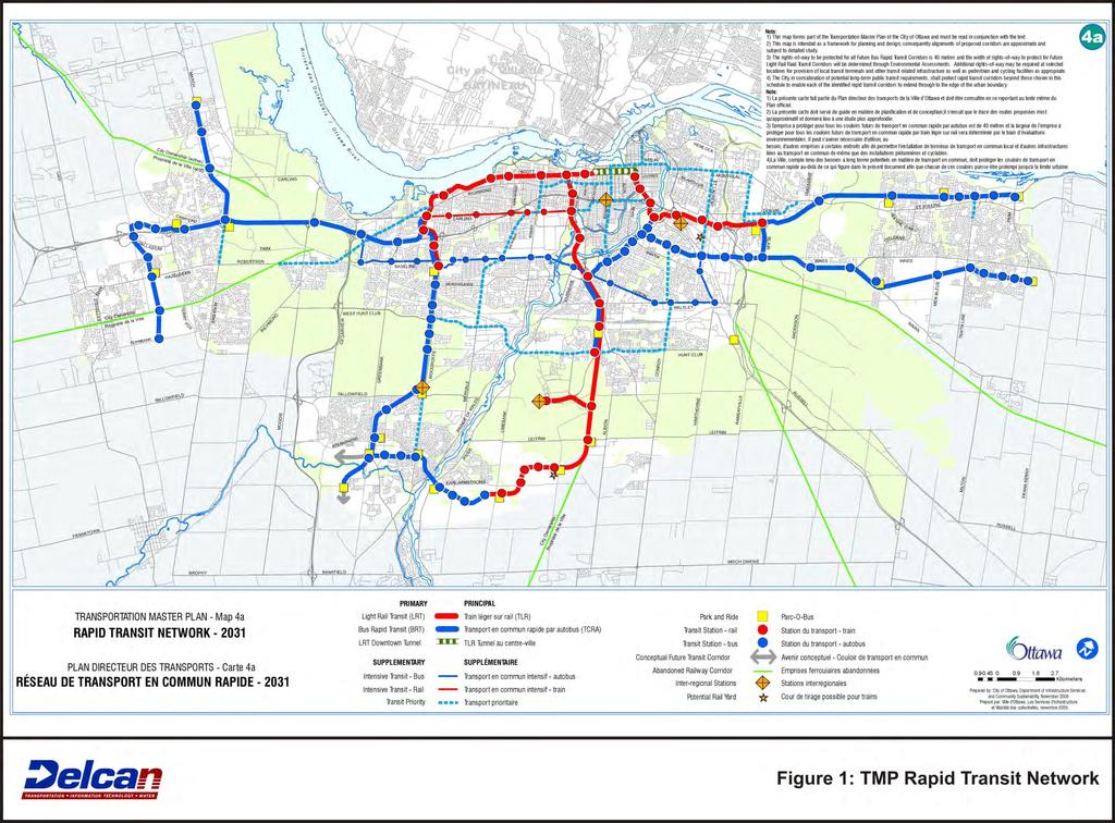
4 In 2008, the City of Ottawa approved an update to its Transportation Master Plan (TMP), a key City document supporting the City s growth management strategy and OP. The 2008 TMP update developed a bold plan for the future of the City and its rapid transit infrastructure out to the year When fully implemented, it will include a Light Rail Transit (LRT) network to complement the groundbreaking Bus Rapid Transit (BRT) program (the Transitway) initiated in the late 1970 s. In the first phase of the plan, which extends out to the year 2021, the City of Ottawa will invest in 40 km of new LRT lines, as well as additional BRT facilities. Figure 1 illustrates the proposed TMP rapid transit network. In developing the planned rapid transit network, the City of Ottawa adopted a strategic inside-out approach, centered on the introduction of a downtown transit tunnel as the long-term solution to congestion issues affecting existing on-street BRT operations in the downtown and set the stage for increased ridership and reduced reliance on private automobile use. This represents a reversal from the previous philosophy followed during implementation of the Transitway program, which placed priority on expansion of rapid transit to suburban neighbourhoods while maintaining on-street BRT operations through the downtown core. 1.2 Project Overview The DOTT project is the cornerstone of the new TMP rapid transit network and includes 12.5 km of new electric light rail transit (LRT) running from Tunney s Pasture Station in the west to Blair Station in the east, via a downtown LRT tunnel. Thirteen stations are proposed along the line, four of which are new underground stations, while the remaining nine stations are existing rapid transit stations which will be converted from BRT to LRT technology along with the existing Transitway corridor between Tunney s Pasture and Blair Stations. Figure 2 illustrates the DOTT project alignment and station locations. To support operation of the transit line, a Maintenance and Storage Facility will be required to house and maintain the new light rail vehicles (LRVs) which will run on the line and on future extensions to the City s LRT network. The facility will also provide maintenance, signalling, communication and control facilities needed for safe and efficient operation of the line and the City s entire planned LRT network. The need for the DOTT project is based on analysis undertaken as part of the TMP, which projected that over the period out to the year 2031: Population will increase 30% Employment will increase by 35% Mode split will increase from 23 to 30%, and Transit ridership will increase by 76%, (or 91.5 million trips) up to 161 million annual trips. The TMP model indicates that there will be a ridership uplift of 9% through the introduction of LRT. This translates to; o 4.6 million new trips in the opening year, o 29 million new trips per year in 2031, and o A cumulative million new trips between an opening in 2019 and The DOTT project will provide a substantial increase in carrying capacity through the City s downtown core and will contribute to significant ridership increases. Ridership on the DOTT line is estimated at: 3
5 o 51 million trips in 2021, and o 76 million trips in More than 40% of all transit trips taken in the City will use the DOTT project for all or part of their journey, with the downtown stations predicted to handle more than 50 million annual trips (or 2/3 of all LRT trips) in Conversion of the existing BRT to LRT technology represents a unique challenge, albeit one which was foreseen in the design of most the original Transitway. In addition to the planning and engineering challenges involved in the conversion of an existing and highlyused rapid transit system, the construction of a deep tunnel and stations underneath a large urban central business district containing many heritage buildings and other sensitive land uses, as well as a UNESCO World heritage site, required innovative solutions to be developed in collaboration with government, business and public stakeholders. In addition to the increases in transit ridership, mobility and capacity which the DOTT project will create, it also provides an excellent opportunity to strengthen the existing land use/transit relationship within the National Capital, as envisioned in the City s OP. This will be achieved by a combination of: reinvestment in and redesign of existing station facilities to attract development and accommodate direct integration of future development opportunities where feasible; the grade-separation of rapid transit through downtown Ottawa, allowing for faster and more reliable travel by public transit; the provision of a new downtown route for rapid transit, free from the constraints of the existing street grid and which better connects major employment, commercial and tourist destinations within the downtown area; reclaiming existing road space currently used for surface transit operations (travel lanes and stations) to strengthen the pedestrian realm within the downtown area, and; taking advantage of LRT technology to increase the capacity of rapid transit serving downtown and other important trip origins and destinations. 1.3 Technology As part of the DOTT Planning and EA Study, Delcan undertook a Rail Mode Selection Study to determine the best rail rapid transit technology for implementation on Ottawa s rapid transit network. This study built on previous work, also undertaken by Delcan, regarding LRT technology issues. The Rail Mode Selection Study confirmed that LRT was the most appropriate rail transit technology for implementation on Ottawa s planned rapid transit network as it allows for high capacity operations on fully grade separated rights-of-way on core network of lines, with the ability to accommodate operations along partially-exclusive rights-of-way on future extensions across Ottawa s greenbelt and into suburban areas, thereby reducing transit infrastructure footprint and cost. This last factor is especially important within the Ottawa context given the challenges which the Greenbelt imposes on provision of transit infrastructure. Not only must the infrastructure be cost-effective enough to deal with the long segments of non-revenue generating corridor, it must be designed to be visually unobtrusive in order to meet National Capital Commission polices regarding use of Greenbelt lands for transportation infrastructure. The entire line between Tunney s Pasture and Blair Station will be grade-separated, allowing for higher-speed, high capacity operations during peak hours. Functional design of the alignment and stations protected for operation of trains of up to 6-cars (180 m), providing for an eventual capacity of over 30,000 people per hour in the peak direction (pphpd) to accommodate travel demand well beyond the 2031 horizon year of the TMP. 4
6 2.0 EXISTING SITUATION 2.1 Transit Currently, the City of Ottawa operates an extensive rapid transit network based on Bus Rapid Transit technology (The Transitway). This network is comprised primarily of gradeseparated bus roadways radiating from downtown Ottawa to connect with suburban communities to the east, west and south. While the Transitway program has successfully increased transit ridership and modal split for trips between outlying suburban areas and downtown, integration with land uses adjacent to rapid transit corridors and stations has been less successful, with some exceptions. Between Tunney s Pasture and LeBreton Station in the west, and from Laurier to Blair Station in the east, the existing BRT system operates on an exclusive bus roadway, fully grade-separated from other traffic. Within the downtown area (between LeBreton and Laurier Stations), buses operate on-street using dedicated transit lanes located on Albert Street (westbound) and Slater Street (eastbound). Downtown Ottawa is currently served by 6 Transitway Stops between LeBreton Station and Campus Station. These are: Bay, Kent, Bank, Metcalfe, Mackenzie-King (Rideau Centre), and Laurier. The downtown Transitway stations all have similar characteristics, and serve a mix of local and rapid transit services. The stations are located at the curb and generally consist of one or more large bus shelters located behind the sidewalk, with no other amenities provided Within the downtown area, the existing OC Transpo BRT service accommodates over 10,000 pphpd, during peak hours. This transit service operates through downtown Ottawa along the one-way pair of Albert and Slater Streets using the dedicated on-street bus lanes and is limited to approximately 180 buses an hour per direction, primarily due to the capacity (green time) available through the 10 signalized intersections along the corridor between Empress Avenue in the west and Waller Street in the east. These signalized intersections must satisfy competing demand for buses, vehicular traffic, pedestrians and cyclists travelling along and across the corridor. Increasingly, downtown Ottawa s existing transit system is plagued by delays due to general traffic, conflicts, accidents and emergency response, inclement weather and special events. The unreliability of transit downtown ripples through the system, causing unpredictable traffic patterns, increased degradation of journey times, increased pollution, and rider dissatisfaction. The 2008 TMP update concluded that the existing downtown surface rapid transit system will no longer be able to expand service to meet the projected travel demand beyond Land Use The area through which the DOTT line travels contains of a wide diversity of land uses, including significant residential, employment, government, cultural, institutional, and recreational uses. The intensity and diversity of land use varies considerably from one end of the study area to the other. Land uses within the study area are governed by a complex policy framework of Federal, Provincial and Municipal land use policies. Likewise, the pattern of existing and planned land uses is very diverse and includes Downtown Ottawa, redevelopment sites, major water courses, open space corridors, employment areas, major transportation infrastructure, and stable residential neighbourhoods. Ottawa s OP identifies the Central Area as the economic and cultural heart of the city, and the symbolic heart of the nation, based on its unique combination of employment, 5
7 government, retail, housing, entertainment and cultural activities. Planning for this area must ensure that walking, cycling and transit have priority. This designation covers the downtown core portion of the study area as well as LeBreton Flats, Rideau Street and the ByWard Market. The City s OP also identifies several mixed-use centres as focused areas for intensification and redevelopment. These centres are limited in number and are strategically located on the City s rapid-transit network and adjacent to major roads. Transit supportive land uses such as offices, high schools, hotels, retail uses and high and medium density residential development are encouraged to locate in these areas. The planning for these areas must consistently ensure that the centres are transit-oriented and that the functional integration of transit and surrounding uses is achieved. While most of the developable land within the study area has been built-out, there exists the potential for the DOTT project to encourage redevelopment in proximity to future rapid transit stations. Redevelopment in proximity to new rapid transit stations which follows the principles of transit-oriented development will assist in meeting City OP goals and objectives with respect to intensification and transit modal split and is a key benefit of the DOTT project. Significant redevelopment potential exists at key stations planned as part of the DOTT project, including: Tunney s Pasture Bayview LeBreton Lees Hurdman St. Laurent Cyrville Blair 3.0 STUDY METHODOLOGY The DOTT Planning and EA Study followed a two-step process. The first stage of the study involved the development of alternative alignments and station designs, resulting in a functional design for the project. This Recommended Plan was approved by Ottawa City Council in January Upon approval of the Recommended Plan, the second stage of the study was initiated. This involved completion of a provincial Environmental Project Report, providing a comprehensive impact assessment of the planned project on all aspects of the natural and social environments. Both phases of the study involved extensive consultation with the affected agencies, downtown business interests and the public. A federal EA for the project, triggered by the requirements of the Canadian Environmental Assessment Act (CEAA) is currently being completed. 3.1 Development of Planning Objectives and Design Criteria The primary method used in developing and evaluating alternatives generated as a part of the planning phase of the study was the creation of project planning objectives and design criteria. These were identified early on in the study by the study team and were presented to the Consultation Groups and general public for their comment and input before being finalized. The project planning objectives and design criteria cover all aspects of the planning, design, assessment and implementation of the DOTT project. The planning objectives developed were as follows: 6
8 Increase transit ridership and mobility Enhance Ottawa s urban character and national stature Stimulate smart growth Create successful rapid transit stations Provide safe and efficient linear infrastructure Provide a safe and efficient tunnel and compatible portals Be compatible with adjacent communities Maintain or improve natural and physical environments Showcase sustainable design best practices Manage construction disruption and risk Result in a wise public investment These objectives and criteria: Enabled a shared understanding by the City, the design team, and all stakeholders of the project and its expectations; Implemented the planning and design directions of the Plan for Canada s Capital, Ontario s Provincial Policy Statement, and the City of Ottawa s Official Plan and Transportation Master Plan Update; Formed the fundamental planning objectives and basic design assumptions; Provided guidance for designers and others to use when trade-offs need to be addressed, and; Provided a basis for the selection of criteria to be used in the evaluation and assessment of alternative designs. Of specific relevance to the integration of transit and land use were the design criteria developed to support the objectives relating to Enhance Ottawa s Urban Character and National Stature, Stimulate Smart Growth, and Create Successful Rapid Transit Stations. These design criteria provided more detail to the planning objectives and addressed specific issues which were evaluated as part of the development of alternative alignments and station designs. Key considerations in assessing alternative alignments, station locations and designs included integration with existing and potential high density employment, residential and institutional land uses. 4.0 PROPOSED PLAN The following is a description of the recommended plan developed for the DOTT project, with an emphasis on specific land use integration opportunities and how they were considered as part of the planning and functional design of the project. 4.1 Tunney's Pasture Station Tunney s Pasture Station is located on the north side of Scott Street, west of Holland Avenue. This station is the western terminus for the DOTT project, and will serve as a major transfer point between LRT and BRT services from the west and southwest areas of the City of Ottawa until such time that the LRT system is expanded further west in accordance with the TMP. A temporary bus terminal is planned to be located on lands immediately north of the existing Transitway station, with direct pedestrian linkages between BRT platforms to accommodate expected passenger flows of 9,000 persons in the peak hour. The lands north of the Transitway Station are designated as a federal node in the NCC s Plan for Canada s Capital, and as a mixed-use centre in the City s OP. Lands to the south, east 7
9 and west are generally low-rise stable residential neighbourhoods, with the area between Parkdale and Holland designated as an extension of the Tunney s Pasture mixed-use area. A Master Planning exercise is currently being undertaken by Public Works and Government Services Canada (PWGSC) to assess future development potential on the site and develop design concepts. It is anticipated that upwards of 20,000 additional jobs could be accommodated within the site, providing a total employment figure of 30,000 at this location. Integration of the station with future PWGSC development plans for the Tunney s Pasture employment is a potential option which is being explored in order to take maximum advantage of the increase in transit capacity which the DOTT project will provide. Once LRT is extended west to Baseline Station and the temporary BRT transfer facilities are no longer required, these lands can be re-purposed for development. The planned underground pedestrian connection between the BRT and LRT platforms would also be able to provide for direct access into other buildings on the site. Figure 3 illustrates the conceptual design for Tunney s Pasture Station. 4.2 Bayview Station Bayview Station is located at the junction between the existing Transitway corridor and the City s O-Train line, which is an existing diesel LRT corridor, planned for future conversion to electric LRT as part of a future phase of the TMP. A future connection to Gatineau, Quebec via an existing railway bridge located north of Bayview Station is being protected. The area surrounding Bayview Station area has been the subject of various planning studies that respond to the area s location adjacent to the O-Train line and the potential opportunity for intensive redevelopment. Much of the lands are currently vacant or underutilized but are anticipated to be redeveloped with medium to high density mixed land uses that are integrated with rapid transit stations. The development concept recommended by the Bayview/Somerset Area Secondary Plan proposes approximately 1,470 residential units (with the civic use at the south end of the Bayview Yard) or 1,590 residential units (with a mixed-use development at the south end of the Bayview Yard), of which 25 percent are intended to be affordable housing units. The LRT alignment and station design developed as part of the Recommended Plan endeavours to maximize the development potential for lands adjacent to the station that are in both public and private ownership, while protecting for future connections with the planned north-south LRT corridor. Figure 4 illustrates the conceptual design for Bayview Station. 4.3 LeBreton Station LeBreton Station is located at Booth Street, and is the main transfer point for OC Transpo services to and from the City of Gatineau (Quebec) via the Chaudière Bridge located to the north. The LRT station will be located underneath a new Booth Street bridge, which will span over the LRT corridor and the adjacent aqueduct located north of the station. The station lies within the southern edge of the LeBreton Flats area. This area is undergoing redevelopment in accordance with the NCC s plans for a new urban community with a mixture of land uses. The plans provide for up to 4,500 dwelling units, 90,000 m 2 of office space, and 20,000 m 2 of retail space. The 40,000 m 2 Canadian War Museum and its adjacent open spaces along the Ottawa River was the first phase of development, having opened in Other developments are now proceeding in a phased manner. The 8
10 development was jointly planned with the LRT corridor allowing for close integration and focusing development over the station. To the east of the station area, the City s ongoing Escarpment Area Planning Study envisages extending redevelopment to the east in order to integrate the LeBreton area with downtown Ottawa. Figure 5 illustrates the conceptual design for LeBreton Station. 4.4 Downtown Tunnel Alignment and Stations The proposed downtown transit tunnel spans roughly 3.2 km from east of Booth Street to south of Mann Avenue, and will fully replace existing on-street rapid transit operations. The tunnel route follows a cross-country alignment, which was developed in order to address technical issues involved in following the existing rapid transit alignment using Albert and Slater Streets, improve LRT geometry and allow improved rapid transit connections to significant trip origins and destinations not directly served by the current rapid transit alignment. The tunnel enters the downtown from the west under Albert Street, with the Downtown West station located in the Lyon/Bay block. The alignment then turns slightly to the north at Bank Street to cross under Queen Street at O Connor, with the Downtown East Station centered between Bank Street and O Connor. The alignment then continues cross-country toward Rideau Street, passing under the Confederation Square area, with a Rideau Station spanning under the Rideau Canal to the area of the Rideau Centre. A curve to the south takes the alignment under Rideau and Waller Streets where the existing Transitway corridor is reached at the east end of the Mackenzie-King Bridge. Following under the existing Transitway corridor to a point south of Laurier Avenue, the alignment crosses under Nicholas Street and follows Colonel By Drive, with Campus Station located in the vicinity of the Corktown Footbridge. South of Campus Station, the alignment curves back under Nicholas Street to regain the existing Transitway alignment at the south end of the University of Ottawa campus. The east tunnel portal would be located south of this location, between Mann Avenue and Lees Station. Each underground station will have a minimum of two direct entrances from the surface to meet access and emergency needs. These station entrances may be located within the public right-of-way or integrated directly into existing or planned development. From an urban design perspective, given the narrow rights-of-way available on many downtown streets, integration of station entrances into development blocks is seen as highly desirable. The philosophy used during the DOTT Planning and EA study was to identify several potential entrance locations for each station and then engage adjacent landowners to determine interest in providing for a connection into a station. Additional connections will be encouraged at developers cost. Significant business interest was expressed in the potential for an extensive network of underground connections extending from the proposed underground stations and connecting multiple buildings, resulting in the creation of an underground city such as those found in Montreal or Toronto. This idea does not form part of the DOTT project, and it is expected that development of such a network, if it occurs, would be evolutionary in nature, and highly dependent on future redevelopment of existing buildings. 4.5 Downtown West Station Downtown West Station will be located under Albert Street, east of Bay Street. This location serves existing development in the west end of downtown. During the course of 9
11 the Planning and EA Study, a proposal was brought forward to locate a new Central Library building on lands which could be directly integrated into the planned rapid transit station. This proposal is no longer being pursued, however opportunity still exists to integrate any private redevelopment of the block bounded by Bay, Lyon, Albert and Laurier into the Downtown West Station. Entrance will still be constructed on private lands outside the road allowance allowing a direct connection to the ultimate building on the site. Also keep sidewalk space free for the additional pedestrian activity (which could increase dramatically around stations). Figure 6 illustrates the conceptual design for Downtown West Station. 4.6 Downtown East Station Downtown East Station will be located north of Albert Street, between Bank Street and O'Connor Street, replacing the existing Bank and Metcalfe Transitway Stations. This station has been located to provide connections to local bus services on Bank Street and serve existing development in the central and east parts of downtown. Underground connections from the east station entrance to the World Exchange Plaza and Sparks Street (west of O Connor Street) are additional possible connections, to be built by others. These connections would extend the weather-protected catchment area of the station to include a significant trip generating destination and support revitalization of the Sparks Street pedestrian mall. Full development achieved, but mode split can still be increased with improved reliability and better connectivity to major buildings. Figure 7 illustrates the conceptual design for Downtown East Station. 4.7 Rideau Station Rideau Station will be located south of Wellington Street, between Confederation Square and Sussex Drive. The placement of the station allows for connections to both the west and east sides of Rideau Canal, providing the potential for a weather-protected pedestrian connection between the National Arts Centre, Confederation Square, and offices on the west side of the canal and the Rideau Centre/ByWard Market area on the east side. A great deal of consideration was involved in determining the location of this station and potential station entrance points from the surface. On the west side of the Rideau Canal, the proposed station entrance is located within a protected viewshed which covers views from the bridges over the Rideau Canal looking towards Parliament Hill. This entrance could allow for a direct underground connection into the National Arts Centre, as well as further underground extensions into existing office buildings on the west side of Elgin Street. The existing Transitway Station (Mackenzie-King) serving the Rideau Centre shopping mall is located along the south side of the shopping mall, on Mackenzie-King Bridge, with local transit and Société de transport de l Outaouais (STO) routes operating along Rideau Street, at the north end of the shopping mall. This configuration serves to drive approximately 20,000 people per day through the shopping mall, an extremely valuable benefit for this retail operation. The proposed LRT station is located along the north side of the shopping mall in order to provide a connection not only to the mall but also to the Parliamentary Precinct and ByWard Market areas. Technical challenges involved in building an underground LRT alignment and station beneath the bridge structure, as well as the sharp turn required at the east end of the bridge in order to regain the existing grade-separated 10
12 Transitway alignment south of Laurier Avenue also were important considerations in relocating the rapid transit alignment and station in this area. There are significant opportunities available to integrate this station with an expanded Rideau Centre, and provide weather-protected access to adjacent buildings and destinations (e.g. DND Headquarters, ByWard Market). Passengers transferring to local or STO buses on Rideau Street would have a weather-protected connection between the on-street bus stops and the LRT platform. Passengers transferring to other local bus services, which will be relocated to serve the existing Mackenzie-King Station, will have a weather-protected connection through the Rideau Centre. Figure 8 illustrates the conceptual design for Rideau Station. 4.8 Campus Station Campus Station is located south of Laurier Avenue, along the western edge of the main University of Ottawa campus, which is the primary land use served by the station. The station also serves the Sandy Hill neighbourhood via pedestrian connections through the university campus, and development located on the west side of the Rideau Canal, reached by an adjacent pedestrian bridge (Corktown Bridge). The University is developing according to its Master Plan which is currently being updated. Most of the developable land within the main campus is already utilized, although several parking lots remain to be redeveloped. Efforts have been made to pedestrianize the interior of the campus in to give priority to pedestrian movements over automobiles within the campus, with improved connections to the existing Transitway Station. The Planning and EA Study determined that the existing Campus Station should be relocated to the west, due to the restricted right-of-way of the existing Transitway located between the university buildings and Nicholas Street. This would allow the existing Transitway alignment to be repurposed to augment capital arrival, provide a buffer between the university and Nicholas Street, and improve pedestrian and bicycle connectivity in the vicinity of the station. Opportunities were explored to provide direct underground pedestrian connections into existing and future development on the campus. Figure 9 illustrates the conceptual design for Campus Station. 4.9 Lees Station Lees Station is located where the existing Transitway crosses under Lees Avenue. As a minor on-line station it is proposed to remain in its current location and general configuration, with upgrades to existing station facilities incorporated as part of conversion to LRT. A new multi-use pathway will be provided through the station area to link the University of Ottawa and Sandy Hill areas with existing City/NCC multi-use pathways located along the Rideau River corridor. These facilities will improve pedestrian and cycling connections to this station. Lees Station serves adjacent high-density residential development and provides for transfers to local bus services on Lees Avenue. A node of high density residential uses exists to the west and south of the Lees station. The University of Ottawa owns the former Lees Campus of Algonquin College, located on the northwest side of the Rideau River, at the Lees Station, and has plans to eventually redevelop this property, as their main campus site is severely constrained by existing development. Figure 10 illustrates the conceptual design for Lees Station. 11
13 4.10 Hurdman Station Hurdman Station is located at the junction between the East and Southeast Transitways, on the east side of the Rideau River, west of Riverside Drive. The station is and will remain a key transfer point between BRT, LRT and local bus services connecting communities to the north, east and south. In addition to transfer activity, Hurdman Station serves several high density residential buildings located to the south along Riverside Drive. A small passenger pick-up and dropoff facility is provided south of the station, and is planned to be expanded as part of the station re-design. The station is directly linked to the City/NCC multi-use pathway system and provides bike racks to maximize the range for local access to the station. The Hurdman area includes those lands on either side of the Rideau River in the vicinity of the East Transitway and Highway 417. There is an abundance of urban land to the north and west of the Hurdman Station that is candidate for redevelopment. Much of that land is owned by the NCC, is publicly accessible, and is currently used for passive recreation purposes. However, the current Transitway through the station area is located at-grade, presenting a challenge to provide access to potential development lands located north of the existing station, along the Rideau River. The solution reached as part of the functional design of the alignment through this area was to raise the LRT alignment onto an elevated structure/berm in order to allow new access roads and existing multi-use pathways to pass under the LRT alignment at-grade. Figure 11 illustrates the conceptual design for Hurdman Station Train Station Train Station is located adjacent to the main VIA Rail station serving the City of Ottawa. Passengers can connect between rapid transit and inter-city rail services between Ottawa- Toronto and Ottawa-Montreal. A mix of low density residential uses and employment uses are adjacent to the study area to the east. The RCMP Headquarters, the City s baseball stadium, and the Hampton Inn hotel complex are to the north of the study area, on the north side of Hwy 417. Other retail and employment uses are located to the east of that, along Coventry Road. The station also serves adjacent office development located east of the station on Tremblay Drive, however emerging retail and office developments located within walking distance to the south are inaccessible due to a lack of a connection through the existing VIA Rail station. The existing Transitway alignment through the station area is one of the segments where design compromises made during the construction of the BRT facility are incompatible with LRT geometry requirements. The solution proposed as part of the functional design was to straighten out the rapid transit alignment to follow a diagonal path across the front of the existing VIA Rail station, allowing sufficient length for LRT platforms and eliminating two existing tight curves to improve rider comfort. This has the effect of moving the rapid transit station slightly further away from the VIA Rail station than the current Transitway Station, however weather-protected pedestrian connections will be extended out from the train station entrance. To improve access to both the VIA Rail and LRT stations, a pedestrian overpass spanning over Highway 417 to the north will provide a connection with development on the north side of the highway, including the Ottawa Baseball Stadium and the Overbrook community. Opportunities to provide a direct pedestrian connection through the existing VIA Rail station 12
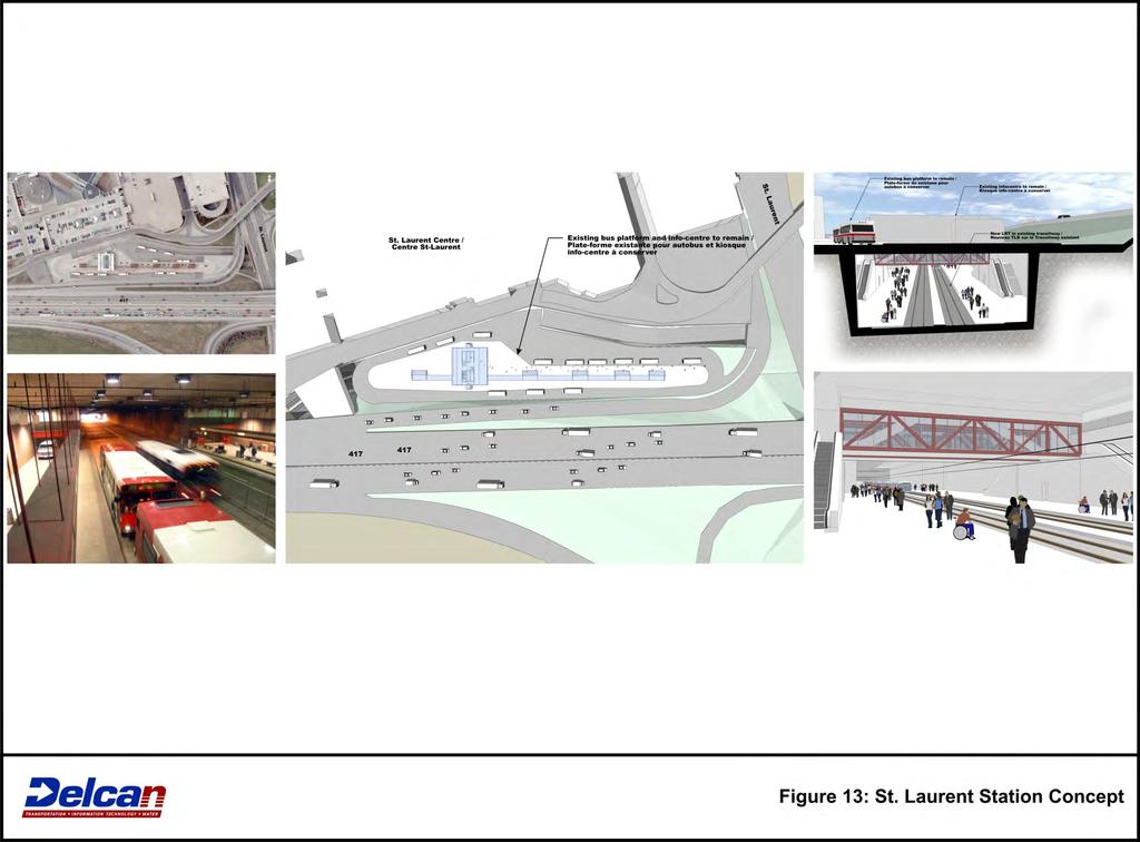
14 in order to link up with development they are also currently being considered but are not part of the DOTT project. Figure 12 illustrates the conceptual design for Train Station St. Laurent Station St. Laurent Station is located on the north side of Highway 417 at St. Laurent Boulevard. The station is currently integrated into the adjacent St. Laurent Shopping Centre, which is one of the largest regional scale shopping centres in Ottawa. To the east of the station is a mixture of medium profile offices uses, hotel and motel businesses and other low density commercial uses. A direct pedestrian link from the eastbound platform serves low density residential development located on the south side of Highway 417, west of the station. As well as serving an established major retail development, the station operates as a major hub for transfers to local bus services serving communities north and south of the station. These services are accessed via an upper level bus terminal. The station is proposed to remain in its current location and platform configuration, with upgrades to station facilities made as a part of the conversion to LRT technology. The St. Laurent Shopping Centre has submitted plans for a major expansion of retail uses on the site, which will further support transit ridership. Additionally, PWGSC is preparing development plans for a major employment node (approximately 3 million square feet of office and mixed-use development) located on lands located south of the station. Part of this proposal would involve construction of a direct pedestrian connection from these lands, across Highway 417, to the upper level of St. Laurent Station. Existing strip commercial development located along St. Laurent Boulevard north of the station represents additional redevelopment opportunity as well as the potential to transform St. Laurent Boulevard from a typical suburban arterial to a more urban thoroughfare, accommodating enhanced local transit services as well as pedestrian and cycling connections to the rapid transit station. Figure 13 illustrates the conceptual design for St. Laurent Station Cyrville Station Cyrville Station is located on the north side of Highway 417, at Cyrville Road. As a minor on-line station, it is proposed to remain in its current location and platform configuration, with upgrades to station facilities made as a part of the conversion to LRT technology. The station currently serves existing office development located immediately west of the station. To the north of the station along the east side of Cyrville Road a higher density residential development extending north of the station to Ogilvie Road is currently under development. A mixture of industrial and smaller commercial businesses is located south of the station, on the south side of Highway 417. The area adjacent to the west of the station is identified in the City s OP as the Cyrville Mixed-Use Centre. As such, there is significant scope for redevelopment of lands in the area. The existing office development west of the station is a typical suburban office park, with low and mid-rise office/retail buildings surrounded by large amounts of surface parking. The potential for improved rapid transit is spurring investigating of options for redevelopment of this property by its owners, including improved integration to Cyrville Station. Figure 14 illustrates the conceptual design for Cyrville Station Blair Station 13
15 Blair Station is located on the north side of Ottawa Road (OR) 174, west of the Blair Road interchange. While contained in the Blair-174 mixed-use centre, the station is largely surrounded by lower density retail immediately adjacent to the north and west, with medium density residential, and some higher density office development on the east side of Blair Road, linked to the station via a pedestrian walkway. An enclosed pedestrian overpass of OR 174 provides direct access to the station from office and residential development located on the south side of the highway. Blair Station is the eastern terminus of the DOTT line, and is expected to stay as such until beyond the current 2031 horizon year of the TMP. The station has been designed to accommodate large numbers of transfers between the LRT and BRT services from the east (the existing East Transitway and future Cumberland Transitway), as well as local bus routes serving residential communities and office developments located north and south of the station area. There is potential for an expansion of the Gloucester Centre shopping mall to integrate into the new station by building over the existing mall access driveway and parking lot which separates the Gloucester Centre from Blair Station. Figure 15 illustrates the conceptual design for Blair Station. 5.0 EXPECTED IMPACTS The DOTT project is expected to have significant impacts on transit and land use integration in Ottawa. From a transit perspective, the current service pattern of express buses circulating within suburban neighbourhoods before accessing the Transitway to travel downtown will be replaced by a hub and spoke system of bus routes focused on LRT stations. The creation of high activity transfer nodes is expected to spur development adjacent to these transfer stations, particularly Tunney s Pasture, Bayview and Blair. Already, private and public landowners have begun to make plans to redevelop sites in close proximity to stations on the DOTT line to take advantage of expected increases in transit access, mobility and capacity. The introduction of transfers, strongly resisted by many suburban riders accustomed to a one-seat ride between home and downtown, will be offset by the provision of more frequent local bus service within neighbourhoods as buses (and drivers) displaced from more inefficient long-haul bus routes are freed up to provide increased service on local routes. Removal of bus congestion in the downtown is a major goal of the DOTT project and the City is already looking at how the benefits of this could be captured. To that end, the City will be undertaking a Downtown Ottawa Mobility Overlay study, the purpose of which is to look at ways to capitalize on the opportunities presented by the implementation of the DOTT project to reclaim space currently given over to surface rapid transit operations in the downtown, and identify how pedestrian and cycling facilities could be improved to provide connections between LRT station entrances and adjacent communities. The study will also examine integration of street-level station entrances into the downtown streetscape and buildings. 6.0 CONCLUSIONS The DOTT project will enhance the character, identity and vibrancy of Ottawa s downtown core, and is the centerpiece of a future LRT network that will span the urbanized areas of the City. It will also help the City achieve its targets for increased reurbanization and intensification and will assist in the protection of agricultural and sensitive environmental 14
16 areas against urban population and expansion pressure. The project was designed to respond to the growth of the City, and provide increased transit capacity into the city core. By providing greater transportation choice, and adding more capacity, riders will see: Reduced travel times, Improved reliability Reduced congestion downtown, More efficient transit operations, and Improved levels of comfort and convenience. Similar approaches to transit station and land use integration are being undertaken as part of the Planning and Environmental Assessment Study for the next phase of Ottawa s LRT network (the Western LRT Corridor), which will extend the DOTT line west to Baseline Station, approximately 10.5 km west and southwest of Tunney s Pasture. When the two projects are completed, a 23 km LRT line will span the Inner Greenbelt Area of the City of Ottawa, continuing the transformation of the current rapid transit system, and providing additional opportunities to strengthen transit and land use integration in our Nation s Capital. References: 1. City of Ottawa 2008 Transportation Master Plan Update 2. Downtown Ottawa Transit Tunnel: Tunney s Pasture to Blair Station via a Downtown LRT Tunnel (DOTT) Planning and Environmental Assessment Study Environmental Project Report 15
17

18
19
20
21
22
23
24
25
26
27
28
29
30
31
178 Carruthers Properties Inc.
 178 Carruthers Properties Inc. Planning Rationale for 178 Carruthers Avenue Site Plan Control Application June 2014 Table of Contents 1.0 Introduction 2.0 Overview of Subject Property 3.0 Current Zoning
ELMVALE ACRES SHOPPING CENTRE MASTER PLAN
 ELMVALE ACRES SHOPPING CENTRE MASTER PLAN Contents 1.0 INTRODUCTION... 2 2.0 LOCATION... 2 3.0 EXISTING CONTEXT... 2 4.0 VISION & GUIDING PRINCIPLES... 2 5.0 LAND USE AND BUILT FORM... 4 5.1 St. Laurent
John M. Fleming Managing Director, Planning and City Planner. Old East Village Dundas Street Corridor Secondary Plan Draft Terms of Reference
 Report to Planning and Environment Committee To: From: Subject: Chair and Members Planning & Environment Committee John M. Fleming Managing Director, Planning and City Planner Old East Village Dundas Street
[PLANNING RATIONALE] For Site Plan Control and Lifting of Holding Zone By-Law 101 Champagne Avenue. May 23, 2014
![[PLANNING RATIONALE] For Site Plan Control and Lifting of Holding Zone By-Law 101 Champagne Avenue. May 23, 2014](/thumbs/75/71599615.jpg "[PLANNING RATIONALE] For Site Plan Control and Lifting of Holding Zone By-Law 101 Champagne Avenue. May 23, 2014") [PLANNING RATIONALE] For Site Plan Control and Lifting of Holding Zone By-Law 101 Champagne Avenue May 23, 2014 Contents 1.0 Introduction... 2 2.0 Site Context... 2 2.1 Adjacent Uses... 2 Figure 1: Site
[PLANNING RATIONALE] For Site Plan Control and Lifting of Holding Zone By-Law 101 Champagne Avenue May 23, 2014 Contents 1.0 Introduction... 2 2.0 Site Context... 2 2.1 Adjacent Uses... 2 Figure 1: Site
13 THORNHILL YONGE STREET STUDY IMPLEMENTATION CITY OF VAUGHAN OPA 669 AND TOWN OF MARKHAM OPA 154
 13 THORNHILL YONGE STREET STUDY IMPLEMENTATION CITY OF VAUGHAN OPA 669 AND TOWN OF MARKHAM OPA 154 The Planning and Economic Development Committee recommends the adoption of the recommendations contained
Welcome. Walk Around. Talk to Us. Write Down Your Comments
 Welcome This is an information meeting introducing the applications for proposed redevelopment of the Yorkdale Shopping Centre site at 3401 Dufferin Street and 1 Yorkdale Road over the next 20+ years,
Ottawa Centretown A Community Design Plan for the Heart of Centretown
 Ottawa Centretown A Community Design Plan for the Heart of Centretown November 2011 ERA Architects DELCAN APPENDICES I Mobility Position II Sustainable Transportation Strategies III Municipal Infrastructure
1.3 TRANSIT VISION 2040 FROM VISION TO ACTION THEME 1: PUTTING TRANSIT AT THE CENTRE OF COMMUNITIES. Fully integrate transit with community planning
 TRANSIT VISION 2040 FROM VISION TO ACTION TRANSIT VISION 2040 defines a future in which public transit maximizes its contribution to quality of life with benefits that support a vibrant and equitable society,
SCARBOROUGH SUBWAY EXTENSION. Scarborough Subway Extension. Final Terms of Reference
 Scarborough Subway Extension Final Terms of Reference 1 1.0 Introduction and Background 1.1 Introduction Toronto City Council recently confirmed support for an extension of the Bloor-Danforth Subway from
The West Vaughan Employment Area Secondary Plan Policies
 Part 2: The West Vaughan Employment Area Secondary Plan Policies 2.1 General Policies It is the policy of Council: 2.1.1. That the West Vaughan Employment Area (the WVEA), identified on Schedule 1, will
Shift Rapid Transit Public Participation Meeting May 3, 2017
 Shift Rapid Transit Public Participation Meeting May 3, 2017 Shift Rapid Transit Initiative Largest infrastructure project in the city s history. Rapid Transit initiative will transform London s public
Port Credit Local Advisory Panel October 20 th Meeting
 Port Credit Local Advisory Panel October 20 th Meeting Focus Of This Evening s Meeting: 1. Hurontario Main Street Higher Order Transit Study 2. Port Credit Mobility Hub & GO Station Parking Structure Study
Director, Community Planning, Toronto and East York District
 Lower Yonge Precinct Plan Update STAFF REPORT ACTION REQUIRED Date: October 16, 2012 To: From: Wards: Reference Number: Toronto and East York Community Council Director, Community Planning, Toronto and
CITY COUNCIL AGENDA REPORT
 CITY COUNCIL AGENDA REPORT Subject: COUNCIL MOTION LRT ALIGNMENT REMOVAL FROM THE TRANSPORTATION MASTER PLAN On February 10, 2016 Councillor Hughes provided notice in accordance with Section 23 of Procedure
38 Queen s University Campus Master Plan Part 1
 38 Queen s University Campus Master Plan Part 1 46 The Campus at the City Scale Chapter 4 The Campus at the City Scale 39 Queen s is an urban University centrally located in Kingston. Decisions made by
YONGE STEELES CORRIDOR SECONDARY PLAN. Young + Wright / IBI Group Architects Dillon Consulting Ltd. GHK International (Canada) Ltd.
 Ltd.") PART A: PREAMBLE 1.0 PURPOSE The purpose of this Secondary Plan is to provide a development framework for intensification of the Yonge/ Steeles corridor including the north side of Steeles Avenue West
PART A: PREAMBLE 1.0 PURPOSE The purpose of this Secondary Plan is to provide a development framework for intensification of the Yonge/ Steeles corridor including the north side of Steeles Avenue West
KANATA CENTRUM 255 KANATA AVENUE OFFICIAL PLAN AMENDMENT ZONING BY-LAW AMENDMENT
 KANATA CENTRUM 255 KANATA AVENUE OFFICIAL PLAN AMENDMENT ZONING BY-LAW AMENDMENT JUNE 2015 PREPARED BY: FOTENN Consultants Inc. 223 Mcleod Street Ottawa, ON K2P OZ8 (613) 730-5709 PREPARED FOR: Kanata
Western Light Rail Transit Corridor Planning and Environmental Assessment Study. Public Open House #2 25 April 2013
 Western Light Rail Transit Corridor Planning and Environmental Assessment Study Public Open House #2 25 April 2013 1 Presentation Overview 2 1. Where We Began Background and Study Area 2. Understanding
141 GEORGE STREET PLANNING RATIONALE
 141 GEORGE STREET PLANNING RATIONALE MINOR ZONING BY-LAW AMENDMENT NOVEMBER 2, 2016 PLANNING RATIONALE 223 McLeod Street Ottawa, ON K2P 0Z8 613.730.5709 fotenn.com INTRODUCTION FOTENN Consultants is acting
3. Endorse the LRT vision in transforming Surrey into Connected-Complete-Livable communities, and more specifically, the official vision statement:
 CORPORATE REPORT NO: R038 COUNCIL DATE: February 20, 2017 REGULAR COUNCIL TO: Mayor & Council DATE: February 16, 2017 FROM: General Manager, Engineering FILE: 8740-01 SUBJECT: Surrey Light Rail Transit
WELCOME and introduction
 1 WELCOME and introduction Mobility Hub Locations within Burlington STUDY OVERVIEW STUDY OBJECTIVES The City of Burlington is developing four Area Specific Plans, one for each of Burlington s Mobility
1.4 TRANSIT VISION 2040 FROM VISION TO ACTION THEME 1: PUTTING TRANSIT AT THE CENTRE OF COMMUNITIES. Fully integrate transit with community design
 TRANSIT VISION 2040 FROM VISION TO ACTION TRANSIT VISION 2040 defines a future in which public transit maximizes its contribution to quality of life with benefits that support a vibrant and equitable society,
Gold Line Bus Rapid Transit Transit Oriented Development (BRTOD) Helmo Station Area Plan
 Helmo Station Area Plan") Appendix F Gold Line Bus Rapid Transit Transit Oriented Development (BRTOD) Helmo Station Area Plan Introduction and Purpose of the Plan The Gold Line Bus Rapid Transit facility is an eleven-mile dedicated
Appendix F Gold Line Bus Rapid Transit Transit Oriented Development (BRTOD) Helmo Station Area Plan Introduction and Purpose of the Plan The Gold Line Bus Rapid Transit facility is an eleven-mile dedicated
Midtown Corridor Alternatives Analysis. Appendix A - Initially Considered Alternatives Screening
 Midtown Corridor Alternatives Analysis Appendix A - Initially Considered Alternatives Screening Arterial BRT on Lake Street - Overall Rating: RATING Metropolitan Council recommendations stated in the Transportation
Urban Design Manual PLANNING AROUND RAPID TRANSIT STATIONS (PARTS) Introduction. Station Study Areas
 Introduction. Station Study Areas") 111111 PLANNING AROUND RAPID TRANSIT STATIONS (PARTS) Introduction The ION rapid transit system will link Waterloo, Kitchener and Cambridge through a central transit corridor (CTC). There are a number
111111 PLANNING AROUND RAPID TRANSIT STATIONS (PARTS) Introduction The ION rapid transit system will link Waterloo, Kitchener and Cambridge through a central transit corridor (CTC). There are a number
Hurontario/Main Street Corridor Master Plan Mississauga and Brampton Building a new and integrated vision for the corridor
 Hurontario/Main Street Corridor Master Plan Mississauga and Brampton Building a new and integrated vision for the corridor Martin Powell, Commissioner of Transportation and Works, City of Mississauga Paper
THE GARDEN CITY PLAN. City of St. Catharines Official Plan. City of St. Catharines
 THE GARDEN CITY PLAN City of St. Catharines Official Plan City of St. Catharines August 2010 APPROVAL INFORMATION This Official Plan of the City of St. Catharines Planning Area, known as the Garden City
Trafalgar Road Corridor Planning Study Open House
 Trafalgar Road Corridor Planning Study Open House June 24, 2013 6:30-8:30 p.m. Oakville & Trafalgar Rooms Overview The Livable Oakville Plan identifies the lands along Trafalgar Road, between the QEW and
THAT the attached Terms of Reference for the Thornhill Centre Street Study be approved.
 COMMITTEE OF THE WHOLE AUGUST 18, 2003 THORNHILL CENTRE STREET STUDY PLANNING FILE: 15.92 Recommendation The Commissioner of Planning recommends: THAT the attached Terms of Reference for the Thornhill
Riverside South. Rapid Transit Study. Riverside South. Value Planning Workshop
 Riverside South Rapid Transit Study Peter Steacy, P. Eng. Program Manager Transportation Environmental Assessments City of Ottawa Value Planning Workshop Christopher Gordon, P. Eng. Project Manager Transportation
The Master Plan Framework
 The Master Plan Framework The East Harbour Master Plan advances the development of 60 acres of former industrial lands east of the Don River. The Master Plan outlines a vision for a vibrant, transit-oriented
Kanata Light Rail Transit Planning and Environmental Assessment Study
 Kanata Light Rail Transit Planning and Environmental Assessment Study Public Open House #2 Transportation Services Department December 7, 2017 Agenda Review study progress Confirm the Preferred Corridor
SUBJECT: GO Station Mobility Hubs Preferred Concepts: Aldershot GO, Burlington GO and Appleby GO. Planning and Development Committee - Public Meeting
 Page 1 of Report PB-76-17 SUBJECT: GO Station Mobility Hubs Preferred Concepts: Aldershot GO, Burlington GO and Appleby GO TO: FROM: Planning and Development Committee - Public Meeting Planning and Building
Executive Summary. NY 7 / NY 2 Corridor
 Executive Summary NY 7 / NY 2 Corridor Transportation and Land Use Study December 2005 Prepared for: Town of Colonie Capital District Transportation Committee Prepared by: Introduction: Land use decisions
Northwest LRT Downtown to. Northwest Edmonton Study. Public Workshops
 Northwest LRT Downtown to Northwest Edmonton Study Public Workshops March 23 & 24, 2010 Welcome Thank you all for attending Welcome Introductions Welcome Our Team s Commitment to You for Tonight To provide
Green Line North Centre City Alignment
 Project overview The Green Line will be an important piece of Calgary's transit network, adding 40 kilometres of track to the existing 59 kilometre LRT system. End-to-end, the line will connect North Pointe
Urban Design Review Panel Submission. The Ottawa Train Yards - Office Development. 405 Terminal Avenue. 17 April Table of Contents.
 Table of Contents PHOTOGRAPHS OF EXISTING SITE CONDITION URBAN DESIGN BRIEF PART A: Summary and Response to City Urban Design Guidelines and Policies PART B: Site Specific Urban Design Objectives PART
K. SMART ASSOCIATES LIMITED
 Planning Justification Report Zoning By-Law Amendment 185 King Street North Waterloo, Ontario April 7th, 2017 Project Reference Number 16-245 K. SMART ASSOCIATES LIMITED CONSULTING ENGINEERS AND PLANNERS
Public Open House #1
 Public Open House #1 TONIGHT S AGENDA Welcome Project Overview The Big Picture The Station Area The Analysis Thoughts about Future Change Breakout Group Discussions Summation / Next Steps Project Overview
1 INTRODUCTION Purpose Project Background PROJECT CONTEXT Background The Capital City Downtown Plan...
 Attachment 3 Contents CONTENTS 1 INTRODUCTION... 3 Purpose... 3 Project Background... 3 2 PROJECT CONTEXT... 9 Background... 9 The Capital City Downtown Plan... 9 The LRT Expansion Plan - LRT Downtown
Regency Developments. Urban Design Brief. Holyrood DC2 Rezoning
 Regency Developments Urban Design Brief Holyrood DC2 Rezoning Stantec Consulting Ltd. 7-31-2017 1. Overview Regency Developments intends to rezone the lands located at 8510 and 8511 93 Avenue, within the
Mark-up of the effect of the proposed Bronte Village Growth Area OPA No.18 on the text of section 24, Bronte Village, of the Livable Oakville Plan
 Mark-up of the effect of the proposed Bronte Village Growth Area OPA No.18 on the text of section 24, Bronte Village, of the Livable Oakville Plan Notes: This document is provided for information purposes
Transportation. Strategies for Action
 Transportation A major priority for the Overlake Neighborhood is to develop a multimodal transportation system. To achieve this system, a balance has to be found among travel, circulation and access needs;
Animating the Rideau Canal December 2013
 Executive Summary Animating the Rideau Canal December 2013 Why study the Rideau Canal? The Rideau Canal has been an important part of Ottawa throughout its history, and has shaped and been shaped by the
PILLAR FOUR INTEGRATE LAND USE & TRANSPORTATION
 PILLAR FOUR INTEGRATE LAND USE & TRANSPORTATION 8 Scarborough Centre on the Move Transportation Master Plan 123 8 Transportation Pillar Four Integrate Land Use & The fourth pillar focuses on the relationship
CITY CLERK. Parkland Acquisition Strategic Directions Report (All Wards)
") CITY CLERK Clause embodied in Report No. 10 of the, as adopted by the Council of the City of Toronto at its meeting held on November 6, 7 and 8, 2001. 10 Parkland Acquisition Strategic Directions Report
CITY CLERK Clause embodied in Report No. 10 of the, as adopted by the Council of the City of Toronto at its meeting held on November 6, 7 and 8, 2001. 10 Parkland Acquisition Strategic Directions Report
Land Use Amendment in Southwood (Ward 11) at and Elbow Drive SW, LOC
 at and Elbow Drive SW, LOC") 2018 November 15 Page 1 of 10 EXECUTIVE SUMMARY This land use amendment application was submitted by Rick Balbi Architect on 2017 August 31 on behalf of Sable Developments Ltd, and with authorization from
2018 November 15 Page 1 of 10 EXECUTIVE SUMMARY This land use amendment application was submitted by Rick Balbi Architect on 2017 August 31 on behalf of Sable Developments Ltd, and with authorization from
QUEEN-RIVER SECONDARY PLAN
 34 QUEEN-RIVER SECONDARY PLAN 34. QUEEN RIVER SECONDARY PLAN 1. INTRODUCTION The Queen-River area is approximately 6.4 hectares and is located at the eastern edge of the Downtown as shown on Map 34-1.
4.1.3 LAND USE CATEGORIES
 4.1.3 LAND USE CATEGORIES a. City Center District The City Center District incorporates the existing character and mix of uses in downtown Belmont to encourage redevelopment and new development in keeping
Clairtrell Area Context Plan
 Clairtrell Area Context Plan March 2005 Urban Development Services City Planning Contents 1. Introduction... 4 2. Development Structure... 6 2.1 Streets... 7 2.1.1 Sheppard Avenue and Bayview Avenue...
900 ALBERT PLANNING RATIONALE MARCH 21, 2016 TRINITY
 900 ALBERT PLANNING RATIONALE MARCH 21, 2016 TRINITY PREPARED FOR: TRINITY Trinity Development Group Inc. Sun Life Financial Centre, East Tower 3250 Bloor Street West, Suite 1000 Toronto, ON M8X 2X9 www.trinity-group.com
PUBLIC OPEN HOUSE HURONTARIO-MAIN CORRIDOR SECONDARY PLAN
 PUBLIC OPEN HOUSE HURONTARIO-MAIN CORRIDOR SECONDARY PLAN Tuesday, February 28, 2012 6pm 9pm 1 st Floor Atrium, City Hall 2 Wellington Street West, Brampton 1 POLICY FRAMEWORK The 2006 Provincial Growth
City of Toronto. Emery Village Transportation Master Plan
 City of Toronto Emery Village Transportation Master Plan May 2009 Emery Village Transportation Master Plan Toronto, ON May 2009 Consulting Inc. 100 York Blvd., Suite 300 Richmond Hill, ON L4B 1J8 Tel:
Report to: Development Services Committee Report Date: September 11, 2017
 ~RKHAM Report to: Development Services Committee Report Date: September 11, 2017 SUBJECT: PREPARED BY: Conceptual Master Plan for the Future Urban Area - Community Structure Plan and Key Policy Direction
Corridor Vision. 1Pursue Minnehaha-Hiawatha Community Works Project. Mission of Hennepin County Community Works Program
 1Pursue Minnehaha-Hiawatha Community Works Project Minnehaha-Hiawatha Community Works is a project within the Hennepin Community Works (HCW) program. The mission of the HCW program is to enhance how the
CHAPTER 7: Transportation, Mobility and Circulation
 AGLE AREA COMMUNITY Plan CHAPTER 7 CHAPTER 7: Transportation, Mobility and Circulation Transportation, Mobility and Circulation The purpose of the Transportation, Mobility and Circulation Chapter is to
McCowan Precinct Plan Study Background & Deliverables
 1 DRAFT & WITHOUT PREJUDICE McCowan Precinct Plan Study Background & Deliverables In September, 2011, City Planning (Scarborough District) began a study of an area within the Scarborough Centre, identified
Pedestrian Project Award Institute of Transportation Engineers
 Pedestrian Project Award Institute of Transportation Engineers Rideau Canal Pedestrian Crossing Planning and Environmental Assessment Report The Setting The Rideau Canal and its adjacent pathways are highly
TORONTO COMPLETE STREETS GUIDELINES
 TORONTO COMPLETE STREETS GUIDELINES Presentation by Fiona Chapman, Manager, Pedestrian Projects Public Realm Section, Transportation Services, City of Toronto June 2017 PURPOSE OF THE PROJECT To develop
3 MARKHAM NORTH-SOUTH LINK CORRIDOR PUBLIC TRANSIT IMPROVEMENTS ENVIRONMENTAL ASSESSMENT UPDATE
 3 MARKHAM NORTH-SOUTH LINK CORRIDOR PUBLIC TRANSIT IMPROVEMENTS ENVIRONMENTAL ASSESSMENT UPDATE The Rapid Transit Public/Private Partnership Steering Committee recommends the adoption of the recommendations
The transportation system in a community is an
 7 TRANSPORTATION The transportation system in a community is an important factor contributing to the quality of life of the residents. Without a sound transportation system to bring both goods and patrons
Alta Vista Transportation Corridor Environmental Study Report November 2005
 Alta Vista Transportation Corridor Environmental Study Report November 2005 6.0 ALTERNATIVE DESIGNS The Preferred Solution to providing additional transportation system capacity through the AVTC study
Bus Rapid Transit Backgrounder. December 2016
 Bus Rapid Transit Backgrounder December 2016 Background The City of London is completing the second stage of Shift, its public transit planning exercise. Shift, focuses on rapid transit, along with vehicular
CHARLES PUTMAN CHARLES PUTMAN AND ASSOCIATES, INC
 MEMORANDUM CHARLES PUTMAN & ASSOCIATES, INC. LAND DEVELOPMENT CONSULTANTS PLANNING ZONING PERMITTING 4722 NW Boca Raton Boulevard, Suite C-106 Boca Raton, Florida 33431 Phone: 561/994-6411 FAX: 561/994-0447
Key Themes and Responses May 2016
 King and Victoria Transit Hub and Waterloo Street Pedestrian Access Key Themes and Responses May 2016 The following summarizes what Regional staff heard about the King Victoria Transit Hub and Waterloo
PART 1. Background to the Study. Avenue Study. The Danforth
 The Danforth 1.1/ Study Purpose & Key Municipal Goals 1.2/ The Local Advisory Committee 1.3/ The Project Team 1.4/ Study Process/Summary of Method 1.5/ Summary of Consultation 1.1 Study Purpose and Key
Former Rockcliffe Airbase Community Design Plan Guiding Design Vision and Principles December 4, 2013
 APPENDIX 5 - Guiding Design Vision and Principles Former Rockcliffe Airbase Community Design Plan Guiding Design Vision and Principles December 4, 2013 Vision Statement The redevelopment of the former
776 and 784 St. Laurent Boulevard City of Ottawa
 Engineering Land / Site Development Municipal Infrastructure Environmental / Water Resources Traffic / Transportation Structural Recreational 776 and 784 St. Laurent Boulevard City of Ottawa Planning Rationale
Mill Woods Town Centre Proposed Rezoning LDA
 Mill Woods Town Centre Proposed Rezoning LDA15 0649 The City of Edmonton has received an application for rezoning and an amendment to the Mill Woods Station Area Redevelopment Plan (ARP) for the Mill Woods
Bank Street Secondary Plan
 1.1 Introduction The is a guide to the long term design and development of the portion of Bank Street between Riverside Drive and Ledbury Park, and provides direction on land use, built form, design, parking,
Welcome to the Oakridge Centre Open House
 Welcome to the Oakridge Centre Open House Why is the City hosting this event? This open house is to inform you of a rezoning application submitted to the City of Vancouver to amend the existing CD-1 (Comprehensive
Complete Neighbourhood Guidelines Review Tool
 Complete Neighbourhood Guidelines Review Tool Prepared By: City of Regina Planning Department October 2014 Page 1 of 14 Community Development Review Checklist for Secondary Plans and Concept Plans The
Chapter 1: Introduction
 Chapter 1: Introduction The Penn Avenue Community Works Corridor Vision and Implementation Framework presents an integrated communitybased vision and a coordinated, long-term implementation framework for
I615. Westgate Precinct
 I615. Westgate Precinct I615.1. Precinct Description The Westgate Precinct is located approximately 18km west of the Auckland city centre. There are seven Sub-precincts in the Westgate Precinct: Sub-precinct
DRAFT Land Use Chapter
 Stevens Creek Urban Village DRAFT 1 18 17 Land Use Chapter INTRODUCTION This Land Use Chapter describes how the Stevens Creek Urban Village will accommodate the growth that is planned for it in the Envision
1.0 INTRODUCTION & BACKGROUND
 1.0 INTRODUCTION & BACKGROUND 1.1 GENERAL The Consulting Team was retained by the City of Edmonton in 2010 to complete a for the replacement of the Walterdale Bridge and the approach roads, as required,
The University District envisions, in its neighborhood
 Envisioning the University District Link Light Rail in Seattle s neighborhoods CIY OF SEALE CONCEP-LEVEL SAION AREA PLANNING RECOMMENDAION RESOLUION # 30165 EXHIBI L Vision 08.2000 he University District
Principal development issues
 Principal development issues The transformation of the Bonaventure Expressway from Saint- Jacques to Brennan Streets will create a major urban boulevard with lanes located on either side of a string of
Appendix E: Evaluation of Network Alternatives - July 2017
 Appendix E: Evaluation of Network Alternatives - July 2017 1 Overview This Appendix provides information used in the corridor level screening and detailed corridor assessment. Corridor Level Screening:
Public Open House. Overview of the Downtown Plan Official Plan Amendment April 23, 2018
 Public Open House Overview of the Downtown Plan Official Plan Amendment April 23, 2018 1 A 25-Year Plan for Downtown To ensure growth contributes positively to Toronto s Downtown as a great place to live,
Create Policy Options Draft Plan Plan Approval. Public Consultation Events. Phase 2
 Background Grandview-Woodland Community Plan In the spring of 2012, the City of Vancouver embarked on a comprehensive community planning program in the Grandview-Woodland neighbourhood. The process has
This page has been intentionally left blank.
 This page has been intentionally left blank. Chapter 3 3-2 3. Employment 3.A Niagara Economic Gateway 3.A.1 General The Niagara Economic Gateway comprises: a) The Gateway Economic Zone which includes all
Table of Contents. Elm Avenue Improvement Plan City of Waco, Texas. Introduction 1. Existing Context 1 Figure 1 2.
 Table of Contents Introduction 1 Existing Context 1 Figure 1 2 Plan Guidelines 3 Future Urban Form 4 The West-End 4 Main Street 6 The East-End 7 Figure 2 9 Public Improvement Recommendations 7 General
1071 King Street West Zoning Amendment Application - Preliminary Report
 STAFF REPORT ACTION REQUIRED 1071 King Street West Zoning Amendment Application - Preliminary Report Date: August 9, 2012 To: From: Wards: Reference Number: Toronto and East York Community Council Director,
Report to: Development Services Committee Report Date: April 24, 2017
 SUBJECT: Cornell Rouge National Urban Park Gateway - Report on Design Charrette and Next Steps PREPARED BY: Lilli Duoba, MES, MCIP, RPP, Manager, Natural Heritage (ext. 7925) REVIEWED BY: Marg Wouters,
Town Center (part of the Comprehensive Plan)
") Town Center (part of the Comprehensive Plan) Mercer Island Town Center Looking North (2014) In 1994, a year-long process culminated in a set of design guidelines and code requirements for the Town Center
Town Center (part of the Comprehensive Plan) Mercer Island Town Center Looking North (2014) In 1994, a year-long process culminated in a set of design guidelines and code requirements for the Town Center
Don Mills Crossing Study and Celestica Lands Development Application Community Meeting, Open House, and Breakout Discussions
 Consultation Summary Don Mills Crossing Study and Celestica Lands Development Application Community Meeting, Open House, and Breakout Discussions This report is not intended to provide a verbatim transcript
URBAN DESIGN BRIEF. 2136&2148 Trafalgar Road. Town of Oakville
 URBAN DESIGN BRIEF 2136&2148 Trafalgar Road Town of Oakville Prepared By: METROPOLITAN CONSULTING INC For 2500674 Ontario Inc November 2016 TABLE OF CONTENTS Page No. 1.0 Introduction/Description of Subject
STUDY AREA LOCATION & CONTEXT:
 UNLOCKING THE POTENTIAL OF THE KEATING CROSS ROAD BUSINESS CORRIDOR A PLAN TO CREATE + RETAIN JOB-GENERATING BUSINESSES AND TO GUIDE INFRASTRUCTURE INVESTMENT The Keating Cross Road Corridor (the Keating
Issues Requiring Future Study
 Issues Requiring Future Study Transportation planning is an ongoing process that tends to identify new issues as it finds solutions for others. Some issues are so complex that a solution to one problem
770 BRONSON AVENUE. Zoning By-law Amendment and Site Plan Control
 770 BRONSON AVENUE Zoning By-law Amendment and Site Plan Control Revised Planning Rationale + Design Brief August 2016 REVISED PLANNING RATIONALE 223 McLeod Street Ottawa, ON K2P 0Z8 613.730.5709 fotenn.com
Sustainable Growth. Sustainable Growth
 2 Sustainable Growth Sustainable Growth SUSTAINABLE GROWTH 2.1 COMMUNITY VISION... 2-5 2.2 THE CITY SYSTEM... 2-7 2.2.1 AREAS... 2-7 2.2.2 CITY-WIDE SYSTEMS... 2-8 2.2.3 PROVINCIAL PLAN BOUNDARIES AND
Concord Community Reuse Project Goals and Guiding Principles. Overarching Goals (OG)
") Concord Community Reuse Project Goals and Guiding Principles Overarching Goals (OG) No priority is implied by the order of presentation of the goals and guiding principles. Overarching goals for the Concord
Concord Community Reuse Project Goals and Guiding Principles Overarching Goals (OG) No priority is implied by the order of presentation of the goals and guiding principles. Overarching goals for the Concord
MOBILITY HUB GUIDELINES 2012 TAC Sustainable Urban Transportation Award Submission BACKGROUND MOBILITY HUB GUIDELINES
 MOBILITY HUB GUIDELINES 2012 TAC Sustainable Urban Transportation Award Submission BACKGROUND Rapid population growth, increasing congestion, and years of under investment in transit in the Greater Toronto
Northwest Rail Corridor and US 36 BRT Development Oriented Transit Analysis 4.4 STATION AREA FINDINGS
 4.4 STATION AREA FINDINGS Each station is different, and each one requires a separate set of recommendations based on the vision for the site. This section outlines an initial TOD strategy and recommendations
St. Clair Avenue West Area Transportation Master Plan
 1 (Between Keele Street and Old Weston Road) Public Information Centre 1 December 2, 2015 2 Welcome Welcome to the first Public Information Centre for the St. Clair Avenue West Area. The panels will present
Local Growth Planning in North Central Green Line Communities
 2018 April 30 Page 1 of 6 EXECUTIVE SUMMARY This report outlines a high-level scope for local growth planning for north central Green Line communities. The catalyst for this review is the significant investments
FORMER CANADIAN FORCES BASE (CFB) ROCKCLIFFE SECONDARY PLAN. Official Plan Amendment XX to the Official Plan for the City of Ottawa
 ROCKCLIFFE SECONDARY PLAN. Official Plan Amendment XX to the Official Plan for the City of Ottawa") FORMER CANADIAN FORCES BASE (CFB) ROCKCLIFFE SECONDARY PLAN Official Plan Amendment XX to the Official Plan for the City of Ottawa 1 INDEX THE STATEMENT OF COMPONENTS PART A THE PREAMBLE PAGE Purpose...
FORMER CANADIAN FORCES BASE (CFB) ROCKCLIFFE SECONDARY PLAN Official Plan Amendment XX to the Official Plan for the City of Ottawa 1 INDEX THE STATEMENT OF COMPONENTS PART A THE PREAMBLE PAGE Purpose...
CONTENTS 2.0 A FRAMEWORK FOR SUSTAINABLE GROWTH 2.1 MANAGING SUSTAINABLE GROWTH THE VISION TO GOALS AND OBJECTIVES 2.3 MARKHAM STRUCTURE
 2 A Framework for Sustainable Growth 2.0 A FRAMEWORK FOR SUSTAINABLE GROWTH CONTENTS 2.1 MANAGING SUSTAINABLE GROWTH THE VISION TO 2031 2.2 GOALS AND OBJECTIVES 2.2.1 Protecting the Natural Environment
WITNESS STATEMENT Of. Ronald Blake. On behalf of the Intervenor The Corporation of the City of Markham
 Filed: 2013-06028 EB-2012-0451 Exhibit L.EGD.COM.2 Page 1 of 7 WITNESS STATEMENT Of Ronald Blake On behalf of the Intervenor The Corporation of the City of Markham In the matter of an application by Enbridge