16-198/ W16-18 Erosion Control, Wetland Protection, Waterbody Crossings & Structures, & Stormwater Management Irwin Jacobs ity of Orono
|
|
|
- Silvia Harrington
- 5 years ago
- Views:
Transcription
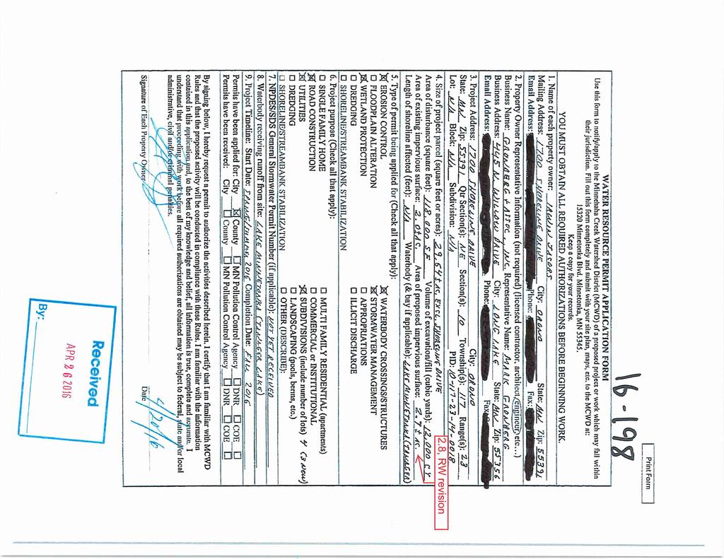
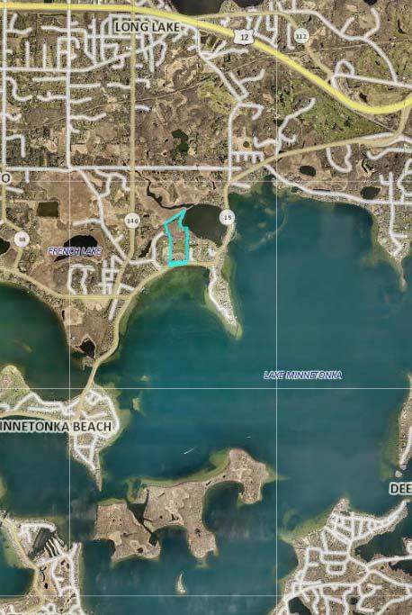
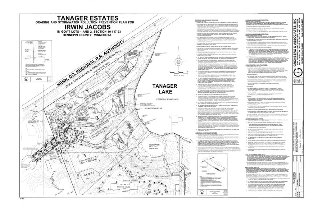
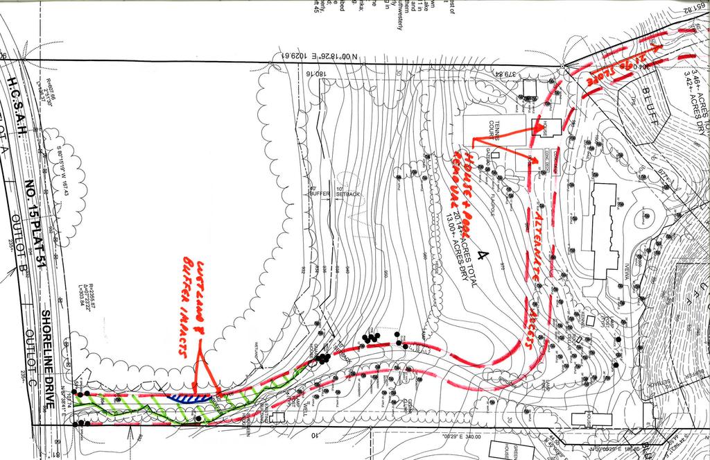
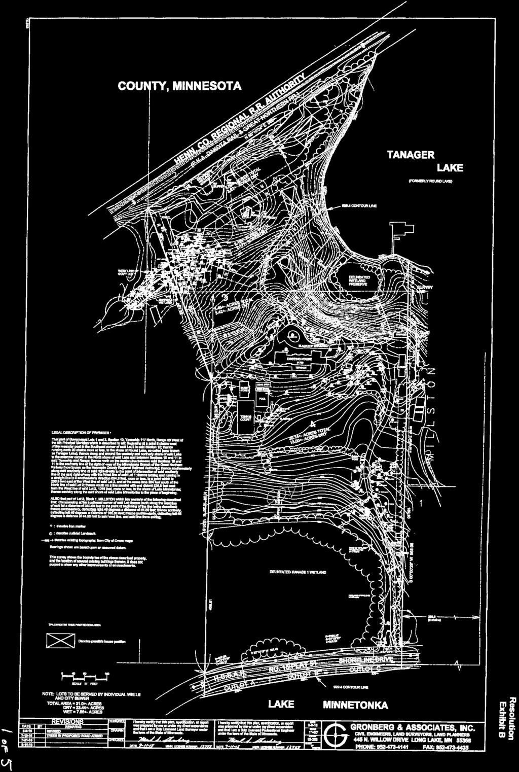
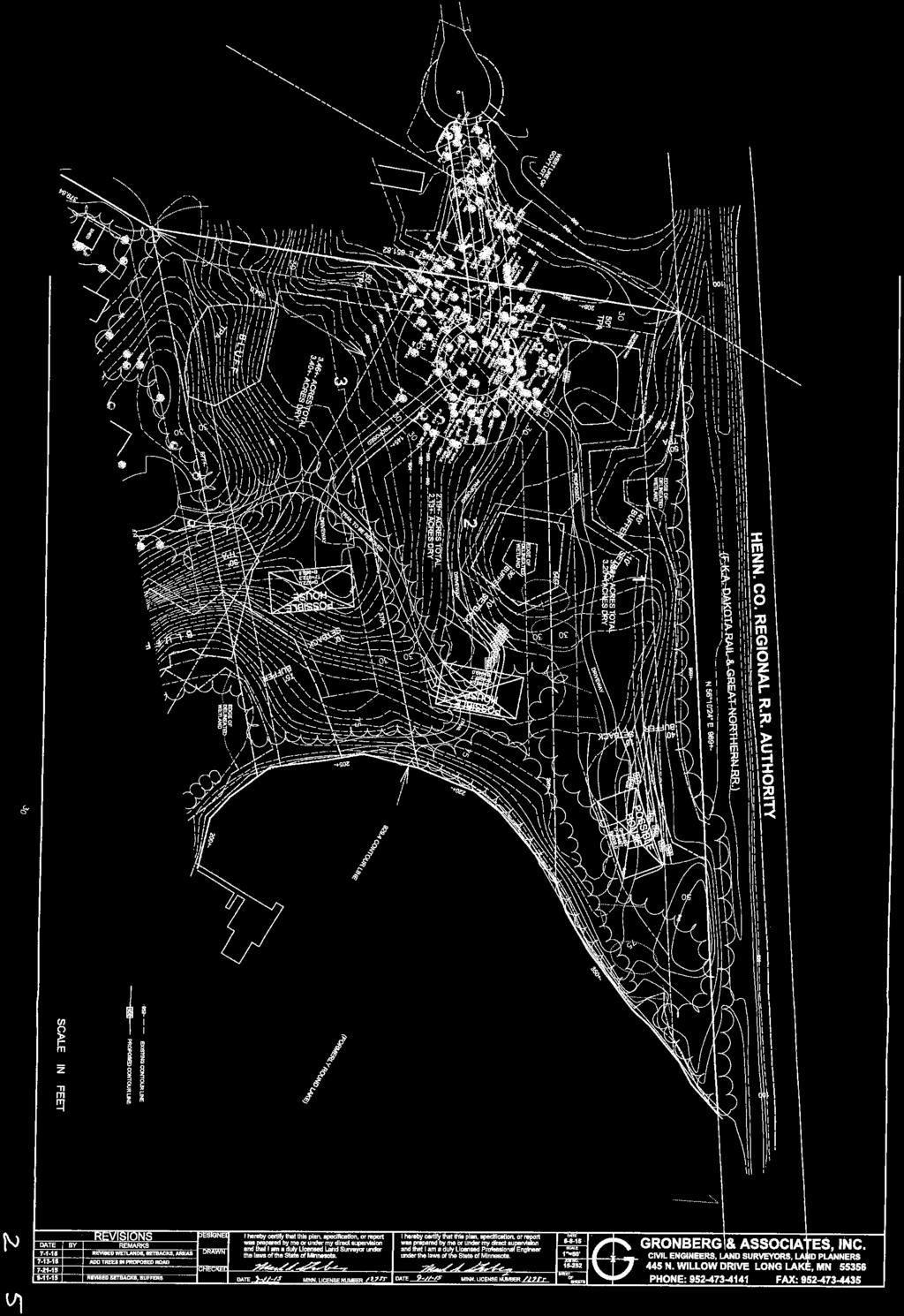
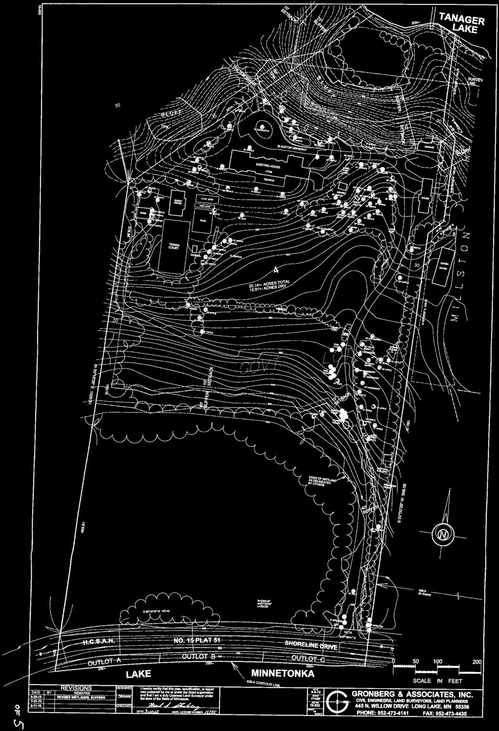
1 Permit Application No.: / W16-18 Rules: Erosion Control, Wetland Protection, Waterbody Crossings & Structures, & Stormwater Management Applicant: Irwin Jacobs/ City of Orono Received:4/26/2016 Project: Tanager Estates Subdivision/ Heritage Lane Extension Complete: 7/12/2016 Location: 1700 Shoreline Drive, Orono/ Heritage Lane Right of Way Noticed: 7/13/2016 Recommendation: Approval of MCWD permit application and WCA Sequencing and Replacement Plan on the following conditions: 1. Submission of financial assurance for Erosion Control ($1,500), Wetland Protection ($5,000), and Stormwater Management ($1,400); 2. Submission of a draft declaration for maintenance of wetland buffers, waterbody crossing, and stormwater facilities for MCWD approval, then recordation; 3. Reimbursement of fees in the amount of $2618; and 4. Confirmation of withdrawal of wetland bank credits from a wetland bank. And stipulations: 1. The applicant must submit as-built drawings of the road upon completion of construction; 2. The applicant must monitor Wetland 4 for one year post-construction of the road to ensure that there are no unpermitted permanent wetland impacts; and 3. Future site plans for the construction of the single family homes proposing impervious area materially inconsistent with the plans approved hereby will require re-analysis and permitting to demonstrate compliance with stormwater management requirements and may require consequent revisions in stormwater management design. All structures must maintain two feet of freeboard between the lowest opening and the high water level of stormwater facilities and waterbodies. Background In collaboration with the City of Orono, Irwin Jacobs has applied for a Minnehaha Creek Watershed District (MCWD) permit for Erosion Control, Wetland Protection, Waterbody Crossing & Structures, and Stormwater Management for the construction of the road and stormwater management infrastructure required for a proposed four-lot subdivision on 1700 Shoreline Drive in the City of Orono. One lot will include the current single family home and associated structures. Construction of the new homes is not proposed at this time or included in this approval. Erosion control permits for the construction of the three new homes will be submitted by contractors at a future time. These future permits must be in accordance with the stormwater requirements of the subdivision. The new properties will be accessed by way of the proposed extension of Heritage Lane through undeveloped City of Orono right-of-way, and the City has joined in the application to the extent that it involves work in the City-owned right of way. As stated in the approved Preliminary Plat for this development, the applicant will construct the proposed extension of the road on behalf of the City of Orono; the extension will be accepted by the City as public road upon its successful completion. The proposed extension of Heritage Lane will result in 950 square feet of wetland fill located solely within the City of Orono right-of-way. The City of Orono has submitted a Wetland Conservation Act (WCA) Sequencing and Replacement Plan application to replace the public value of the wetland lost as a result of impact. Since the extension of Heritage Lane is directly connected to the subdivision of 1700 Shoreline Drive, the City s WCA Replacement Plan is supported by plans included in Jacob s MCWD permit application. The project proposes a 0.9-acre increase of impervious cover over the 29.6-acre site and 950 square feet of permanent wetland impact within the City of Orono right-of-way. The parcel ultimately drains to Tanager Lake. The applicants have submitted all exhibits, plans, and materials necessary to analyze compliance with MCWD and WCA rules. No variances from MCWD rule provisions are needed for approval of the permit. This permit and WCA Replacement Plan are before the Board of Managers for determination at the request of members of the public.
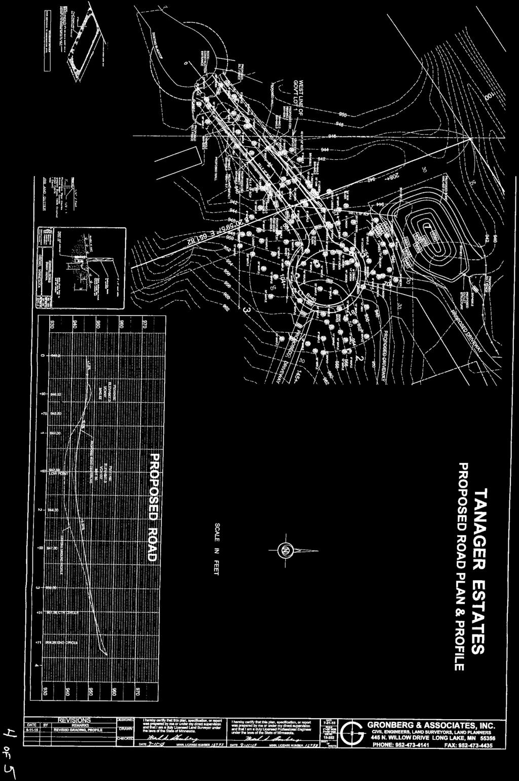
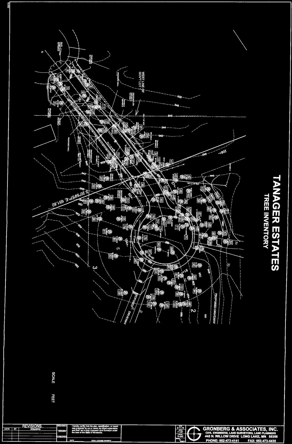
2 District Rule Summary Erosion Control The District exercises regulatory authority for erosion control in the City of Orono. The Erosion Control rule is applicable for any project exceeding 5,000 square feet of land disturbance or 50 cubic yards of excavation. The proposed project involves approximately 2.7 acres of land disturbance, therefore the Erosion Control rule is triggered. Erosion control best management practices including a rock construction entrance, silt fence, inlet protection, and tree protection are provided where necessary. A vegetative stabilization plan including the incorporation of sixinches of topsoil into underlying soils prior to final stabilization has also been provided. Concrete washout will be off-site. The NPDES permit will be obtained by the contractor prior to receipt of the MCWD permit. Erosion control practices meet District requirements. Wetland Protection and Wetland Conservation Act (WCA) The District exercises regulatory authority for Wetland Protection in the City of Orono. The District is the local government unit charged with administering the Wetland Conservation Act in the City of Orono. The District s Wetland Protection rule is applicable for any project proposing to drain or fill a wetland, and the wetland buffer provisions apply to work triggering the Stormwater Management or the District s Waterbody Crossings & Structures rule. This project proposes filling in a wetland and triggers the Stormwater Management and Waterbody Crossings & Structures rule, therefore the Wetland Protection rule is triggered. The Wetland Conservation Act (WCA) governs draining, filling and excavation in wetlands other than public water wetlands. This project proposes filling in a wetland within City of Orono right-of-way. A complete Wetland Conservation Act (WCA) application for Boundary and Type for the project parcel and the right-of-way was received on June 16 th, A WCA Notice of Decision approving the boundaries & types for the six wetlands on-site was issued on August 12 th, The project proposes 950 square feet of permanent fill in the portion of Wetland 4, a Type 1, Seasonally Flooded Basin that is on the City right-of-way for the purpose of extending Heritage Lane in order to provide access to the proposed subdivision on 1700 Shoreline Drive. Wetland 4 is a Manage 2, non-public water wetland. As defined under Subp. 1 of WCA, the public value of Wetland 4 is primarily B: flood water and stormwater retention and to a lesser extent, A: water quality and C: fish, wildlife, and native plant habitat. Wetland 4 extends outside of the right-of-way onto properties not owned by the City or Irwin Jacobs. The City submitted a complete WCA Sequencing and Replacement Plan application supported by the project proponent on July 1 st, A complete Sequencing application must demonstrate that an activity impacting a wetland complies with Subp. 1A-E. Under Subp. 1A, the applicant must first avoid direct or indirect impacts that may destroy or diminish the wetland under the criteria listed in Subp. 3A-3C. Under Subp. 3A, avoidance is not required based on any of the special circumstances indicated under Since this project is not wetland dependent under Subp. 3B, the applicant must provide an alternative analysis under Subp 3C: Alternative 1 was a no-build alternative; however, this alternative would not achieve the project s goals of providing access to the proposed subdivision on 1700 Shoreline Drive. Alternative 2 was to access the three new properties through an extension of the current single family home s driveway. Alternative 2 would require extensive grading through steep slopes and 1000 square feet of impacts to Wetland 5, a Manage 1 public water wetland with hydrologic connection to Lake Minnetonka that is of higher public value and quality than Wetland 4. Under Alternative 2, there would not be a designated buffer between the road and the eastern side of Wetland 5. Since the alternatives do meet the requirements of Subp. 3C(2)B (being in accordance with accepted engineering standards and practices) or Subp. 3C(2)D (being an environmentally preferable alternative), the alternatives were not considered feasible or prudent.
3 Under Subp. 1B, projects that cannot avoid impact must minimize impact to the wetland. The applicant minimizes impact by stabilizing the road with a retaining wall rather than side slopes, which would have required greater amounts of fill. The applicant will not have to rectify impact as required by Subp. 1C, as there are no proposed temporary wetland impacts. The applicant reduces impacts to Wetland 4 over time as required under Subp. 3D through declared maintenance of the storm sewer pipe and stormwater pond which replace the hydrologic function of Wetland 4 (discussed below). Correct maintenance of this infrastructure will maintain adequate hydrology to the non-impacted portions of Wetland 4. The applicant proposes to replace unavoidable impacts as required by Subp. 3E and the MCWD Wetland Protection rule through the purchase of wetland banking credits at a ratio of 2:1 from a wetland bank within the same bank service area, as provided for in The City has provided a signed purchase agreement for 1900 square feet of wetland bank credits from Wetland Bank #1375. The City did not pursue project-specific replacement, because there is not sufficient land area within the City of Orono right-of-way to mitigate for wetland impacts. Replacement was considered via a project within the 1700 Shoreline Drive subdivision, following direction in the TEP s August 3 rd findings; however, wetlands on 1700 Shoreline Drive have not been historically impacted. Therefore, on-site mitigation would result in created, rather than restored, wetland which is less preferable than the use of banked wetland credits. Furthermore, it would be difficult to ensure the restoration s success due to its small size and location on private property. For these reasons, banking was determined to be the preferred alternative to replace the public value of the filled portion of Wetland 4. While not included as part of the Replacement Plan mitigation credits, the public value of Wetland 4 will also be replaced in part through the proposed installation of a stormwater pond on the 1700 Shoreline Drive property. A storm sewer pipe will be placed one foot above the bottom elevation of Wetland 4 to direct displaced water from the Wetland under the road to a stormwater pond located on 1700 Shoreline Drive. Water from the stormwater pond will then infiltrate into the ground. By storing and infiltrating the stormwater, the proposed stormwater pond replaces the public values of B: flood water and stormwater retention and A: water quality of Wetland 4. Therefore, the applicant demonstrated that the proposed activity complies with the principles required by a Sequencing Analysis under Subp. 1A-E. The TEP met on August 3 rd, 2016 to review the application and confirm that findings from the TEP s January 12 th, 2016 meeting had been addressed. The TEP was in agreement with the Sequencing analysis. The TEP also agreed that direct and indirect impacts to the portions of Wetland 4 located on properties not owned by the City or Jacobs were avoided because an adequate drainage area is maintained and one-foot of ponding is provided under the wetland s outlet to the new stormwater pond. The TEP stipulated that an as-built survey of the road must be submitted and monitoring of Wetland 4 must continue for one year following completion of the road to confirm that no unpermitted wetland impacts had occurred. Under Section 2B of the MCWD Wetland Protection rule, a permit is required from the District pursuant to the excavation and buffer provisions in Sections 4 and 5 of the Rule respectively. Section 4, Excavation, is not relevant to this project as no excavation is proposed. Under Section 5A of the MCWD Wetland Protection rule, buffers must be placed adjacent to all wetlands that will be impacted or are downgradient from activity and around each wetland that will be disturbed. Therefore, Wetlands 1, 2, 3, 4, and 6 are subject to Sections 5B-D of the Wetland Protection rule. Wetland 5 is not subject to 1 Irwin Jacobs originally applied for a de Minimis exemption on January 11 th, 2016 for the proposed wetland impacts. During a Technical Evaluation Panel (TEP) meeting on January 12 th, 2016, the TEP determined that the project was not eligible for a de Minimis exemption because the proposed impact area is on City of Orono right-of way rather than Jacobs property. Since the proposed impact is greater than five percent of the City of Orono s portion of the wetland, de Minimis criteria were not met ( Subp.8.c.2). The City of Orono was directed by the TEP to submit a WCA Sequencing and Replacement Plan application.
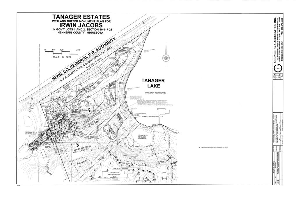
4 Sections 5B- D, because it is not downgradient of activity and will not be disturbed by the proposed landdisturbing activity. Buffer width was determined as required under Section 5B. The management classes for Wetlands 1, 3, and 6 were based on MCWD s functional assessment of wetlands; the management classes for Wetlands 2 and 4 were based on a Minnesota Routine Assessment Method report evaluating the functions and values of the wetlands provided by the applicant. Buffers will be provided around Wetlands 1, 2, 3, and 6 in accordance with their management class. The City cannot provide buffer around Wetland 4 in compliance with the rule because of the limited extent of the right-of-way adjacent to the Wetland, as allowed under Section 6E. Buffer averaging under Section 6C is provided around the Wetland 1 and 6 complex. The buffer width is reduced to between 37.5 and 50 feet on the eastern side of Wetland 1, however, compliant buffer is proposed around the entire wetland. The reduced buffer area, 22,200 square feet, is provided on the southern portion of Wetland 6. Buffer averaging is not proposed around the other wetlands. Wetland Management Class Base Buffer Width Provided Buffer Width 1 Preserve Preserve Permanent buffer monuments are provided for in accordance with Section 5D. A recorded declaration of the buffer as required under Section 5C will be a condition of the permit s final approval. Therefore, the proposed project complies with Section 5 of the Wetland Protection rule. There is currently a trail in the buffer of Wetland 1 that the applicant proposes to remove. Following removal of the trail, the area is proposed to be revegetated in accordance with Section 7 of the Wetland Protection Rule. The buffers of other on-site wetland are not proposed to be disturbed, therefore the requirements for revegetation of buffer areas in Section 7C of the rule do not apply. The wetland protection plans meet the District s requirements. Waterbody Crossings & Structures The District exercises regulatory authority for Waterbody Crossings & Structures in the City of Orono. The Waterbody Crossings & Structures rule is applicable anytime a road, utility, bridge or associated structure comes in contact with the bed or bank of any waterbody. The proposed extension of Heritage Lane will cross Wetland 4, therefore the rule is triggered. Under the Waterbody Crossings & Structures rule, hydraulic capacity must be maintained. As Wetland 4 s storage capacity is proposed to be reduced by fill, a storm sewer pipe will be installed under the road to direct displaced water from Wetland 4 to the proposed stormwater pond designed for the Development. The proposed waterbody crossing was analyzed under the four criteria required by the Waterbody Crossing & Structures rule. 1) The extension of Heritage Lane meets a demonstrated specific need, which is access to the three proposed new homes within the 1700 Shoreline Drive subdivision. 2) Adequate hydraulic capacity is retained as the crossing is designed to convey drainage from the wetland to the proposed stormwater pond such that the normal water level of the wetland will be maintained and the 100-year high water level will be reduced by 2.03-feet on the north side of the proposed road and 2.51-feet on the south side of the proposed road. 3) The proposed waterbody crossing is exempt from providing navigational capacity as Wetland 4 is not navigable. 4) There is not sufficient depth and width to provide upland bank passage; multiple offset culverts are not feasible; the project is exempt from providing a wildlife shelf as is it is a rural section low traffic road.
5 The two other alternatives considered under the Waterbody Crossings & Structures were 1) no-build and 2) changing the access route to the current property owner s driveway. These alternatives were rejected for the reasons described in the Wetland Protection section as not being feasible or prudent. The proposed alternative is the minimal impact solution. The waterbody crossings & structures plans meet the District s requirements. Stormwater Management The District exercises regulatory authority for Stormwater Management in the City of Orono. The Stormwater Management rule is applicable anytime there is new impervious surface or replacement of existing impervious surface. This project proposes a 0.9-acre increase of impervious surface, therefore the rule is triggered. For sites undergoing redevelopment that are greater than one acre with less than 40% site disturbance and less than a 50% increase in impervious surface, volume control, rate control, and phosphorus control requirements apply to the new impervious surfaces. Size of Site (ac) Site Drains To Existing Impervious (ac) Proposed Impervious (ac) 29.6 (2.7 acres disturbed) Lake Minnetonka (Tanager Lake) To meet the District s volume control rule, the applicant must provide 3,340 cubic-feet of abstraction. To achieve this, the applicant proposes to construct an infiltration basin and four raingardens. Infiltration rates were determined based on soil borings provided by the applicant which match the infiltration rates prescribed by MPCA guidelines. The infiltration practices are designed to provide 4,800 cubic-feet of infiltration, which is greater than the 3,340 cubic-feet volume that is required. Infiltration practices are designed to drawdown within 48-hours. The infiltration practices satisfy the volume requirement. The phosphorus requirement is met by meeting the volume requirement. The rate control requirement mandates that there can be no-net increase in the peak runoff rate for the 1-, 10-, and 100-year storm events at the downgradient property boundary. All runoff from the site is directed to Tanager Lake or to a stormwater pond/infiltration basin for treatment before being discharge to Tanager Lake. Although rates are increased within certain drainage areas, the runoff rate decreases to the ultimate discharge point (Tanager Lake). The practices described above also provide enough storage to decrease peak run-off rates, therefore the District s rate control requirements are met: Drainage Area 1-yr Rates (cfs) 10-yr Rates (cfs) 100-yr Rates (cfs) Exist. Prop. Exist. Prop. Exist. Prop. Area Area Area Area Total to Tanager Lake Of the downstream lakes and waterbodies, only Wetland 4 had an increased drainage area under the proposed plan. Impacts to Wetland 4 were analyzed under Section 8 of the Stormwater Management rule. No increases in the bounce or inundation to Wetland 4 are proposed for the 1-, 10-, or 100-year storm events: Wetland 1-yr Bounce (ft) 10-yr Bounce (ft) 100-yr Bounce (ft) Exist. Prop. Exist. Prop. Exist. Prop. Wetland yr Inundation (duration) 10-yr Inundation (duration) 100-yr Inundation (duration) Wetland Exist. Prop. Exist. Prop. Exist. Prop. Wetland
6 There is at least two vertical feet of separation between the proposed low opening of structures and the 100- year high water level of all proposed stormwater facilities and waterbodies. Future plans for the construction of the new homes must show that the lowest opening for the house adjacent to Rain Garden 3 is above , that the lowest opening for the house adjacent to Rain Garden 4A is above , and that the lowest opening for the house adjacent to Rain Garden 4B is above The proposed stormwater management plan meets the District s requirements. Summary: Irwin Jacobs is proposing a four-lot subdivision project and associated road extension that will trigger the District s Erosion Control, Wetland Protection, Stormwater Management, and Waterbody Crossings & Structures rule and a Wetland Conservation Act Replacement Plan. The project as proposed meets the applicable requirements under each of these District rules and the Wetland Conservation Act. Staff recommends approval of the MCWD permit application and Wetland Conservation Act Replacement Plan with the conditions provided above. Attachments: 1. Permit Application 2. Site Location 3. Site Plan 4. Wetland Buffer Monument Locations 5. Alternative Road Access Site Plan 6. WCA Boundary and Type Notice of Decision- Approved August 12 th, WCA Replacement Plan Notice of Application- Completed July 1 st, Draft WCA Replacement Plan Notice of Decision 9. TEP Findings Report- January 12 th, TEP Findings Report- August 3 rd, City of Orono Resolution of the City Council 6569: A Resolution Granting Preliminary Plat Approval for a Class II Subdivison of Property Located at 1700 Shoreline Drive 12. Development Review prepared for the Foxhill Neighborhood Association- November 6 th, 2015 Rachel Workin Date:
7
8
9
10
11
12
13 Minnesota Wetland Conservation Act Notice of Decision Local Government Unit (LGU) Minnehaha Creek Watershed District Address Minnetonka Blvd Minnetonka, MN Applicant Name Irwin Jacobs & City of Orono 1. PROJECT INFORMATION Project Name 1700 Shoreline Drive Date of Application 6/4/15 (Incomplete) 6/16/15 (Complete) Application Number W15-21 Attach site locator map Type of Decision: Wetland Boundary or Type No-Loss Exemption Sequencing Replacement Plan Banking Plan Technical Evaluation Panel Findings and Recommendation (if any): Approve Approve with conditions Deny Summary (or attach): 2. LOCAL GOVERNMENT UNIT DECISION Date of Decision: 8/12/15 Approved Approved with conditions (include below) Denied LGU Findings and Conclusions (attach additional sheets as necessary): BWSR Forms Page 1 of 3
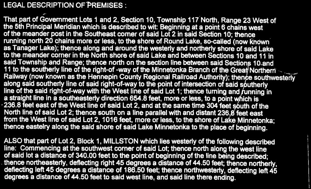
14 Irwin Jacobs and the City of Orono applied for wetland boundary & type confirmation for the wetlands located at 1700 Shoreline Drive and on the Heritage Lane Extension Easement in the City of Orono, Hennepin County, Minnesota (PID ). Legal description: Section 10, Township 117N, Range 23W. A wetland delineation was conducted by Svoboda Ecological Resources on April 23 and 27, A complete delineation report and WCA application were submitted to MCWD on 6/16/15. Six wetlands were delineated on site. Wetland 1 was identified as a Type 3 shallow marsh/type 4 deep marsh adjacent to Tanager Lake; Wetlands 2 and 4 were identified as forested, Type 1 seasonally flooded basins; Wetland 3 was identified as a Type 3 shallow marsh; Wetland 5 was identified as a Type 3 shallow marsh/type 4 deep marsh; and wetland 6 was identified as a Type 3 shallow marsh with Type 2 fresh, wet meadow fringe. Two DNR Public Waters are present on site. MCWD and BWSR reviewed the boundaries in the field on 7/28/15. MCWD and BWSR requested that additional flags be positioned around Wetland 4 to fill in gaps in the flagged boundary but otherwise were in agreement with the boundaries of the wetlands on site as they relate to the two property boundaries. MCWD and BWSR discussed that the boundaries of Wetland 4 extend off of the two subject properties, and advised that any future impacts proposed for Wetland 4 must also consider any direct or indirect impacts to the portions of Wetland 4 not covered by this wetland delineation. MCWD approves the wetland boundaries and types as delineated in the field and documented in the delineation report for the two subject parcels. This decision is valid for five years. A future project located on this property may require a permit from the MCWD. For Replacement Plans using credits from the State Wetland Bank: Bank Account # Bank Service Area County Credits Approved for Withdrawal (sq. ft. or nearest.01 acre) Replacement Plan Approval Conditions. In addition to any conditions specified by the LGU, the approval of a Wetland Replacement Plan is conditional upon the following: Financial Assurance: For project-specific replacement that is not in-advance, a financial assurance specified by the LGU must be submitted to the LGU in accordance with MN Rule , Subp. 9 (List amount and type in LGU Findings). Deed Recording: For project-specific replacement, evidence must be provided to the LGU that the BWSR Declaration of Restrictions and Covenants and Consent to Replacement Wetland forms have been filed with the county recorder s office in which the replacement wetland is located. Credit Withdrawal: For replacement consisting of wetland bank credits, confirmation that BWSR has withdrawn the credits from the state wetland bank as specified in the approved replacement plan. Wetlands may not be impacted until all applicable conditions have been met! LGU Authorized Signature: Signing and mailing of this completed form to the appropriate recipients in accordance with , Subp. 5 provides notice that a decision was made by the LGU under the Wetland Conservation Act as specified above. If additional details on the decision exist, they have been provided to the landowner and are available from the LGU upon request. Name Beth Brown Title Permitting Technician BWSR Forms Page 2 of 3
15 Signature Date 8/12/15 Phone Number and (952) THIS DECISION ONLY APPLIES TO THE MINNESOTA WETLAND CONSERVATION ACT. Additional approvals or permits from local, state, and federal agencies may be required. Check with all appropriate authorities before commencing work in or near wetlands. Applicants proceed at their own risk if work authorized by this decision is started before the time period for appeal (30 days) has expired. If this decision is reversed or revised under appeal, the applicant may be responsible for restoring or replacing all wetland impacts. This decision is valid for three years from the date of decision unless a longer period is advised by the TEP and specified in this notice of decision. 3. APPEAL OF THIS DECISION Pursuant to MN Rule , any appeal of this decision can only be commenced by mailing a petition for appeal, including applicable fee, within thirty (30) calendar days of the date of the mailing of this Notice to the following as indicated: Check one: Appeal of an LGU staff decision. Send petition and $0 fee (if applicable) to: Minnehaha Creek Watershed District Minnetonka Blvd Minnetonka, MN Appeal of LGU governing body decision. Send petition and $500 filing fee to: Executive Director Minnesota Board of Water and Soil Resources 520 Lafayette Road North St. Paul, MN LIST OF ADDRESSEES SWCD TEP member: Stacey Lijewski stacey.lijewski@co.hennepin.mn.us BWSR TEP member: Ben Meyer ben.meyer@state.mn.us LGU TEP member (if different than LGU Contact): DNR TEP member: Kate Drewry kate.drewry@state.mn.us DNR Regional Office (if different than DNR TEP member): Brooke Haworth - brooke.haworth@state.mn.us WD or WMO (if applicable): Applicant (notice only) and Landowner (if different): Irwin Jacobs mbsteadman@cbburnet.com, City of Orono jloftus@ci.orono.mn.us Members of the public who requested notice (notice only): Frank Svoboda (SER) franks@gpsinnovations.com, Christine Mattson (City of Orono) cmattson@ci.orono.mn.us Corps of Engineers Project Manager (notice only): Melissa Jenny melissa.m.jenny@usace.army.mil BWSR Wetland Bank Coordinator (wetland bank plan applications only) 5. MAILING INFORMATION For a list of BWSR TEP representatives: For a list of DNR TEP representatives: Department of Natural Resources Regional Offices: NW Region: NE Region: Reg. Env. Assess. Ecol. Reg. Env. Assess. Ecol. Central Region: Reg. Env. Assess. Southern Region: Reg. Env. Assess. Ecol. BWSR Forms Page 3 of 3
16 Div. Ecol. Resources 2115 Birchmont Beach Rd. NE Bemidji, MN Div. Ecol. Resources 1201 E. Hwy. 2 Grand Rapids, MN Ecol. Div. Ecol. Resources 1200 Warner Road St. Paul, MN Div. Ecol. Resources 261 Hwy. 15 South New Ulm, MN For a map of DNR Administrative Regions, see: For a list of Corps of Project Managers: or send to: US Army Corps of Engineers St. Paul District, ATTN: OP-R 180 Fifth St. East, Suite 700 St. Paul, MN For Wetland Bank Plan applications, also send a copy of the application to: Minnesota Board of Water and Soil Resources Wetland Bank Coordinator 520 Lafayette Road North St. Paul, MN ATTACHMENTS In addition to the site locator map, list any other attachments: Approved wetland boundaries BWSR Forms Page 4 of 3


17 Wetland 3 SP 1-1 Up ^_^_ SP 1-1 Wet SP 3-1 Wet ^_^_ SP 2-1 Wet SP 4-1 Up SP 4-1 Wet ^_^_ SP 3-1 Up SP 2-1 Up ^_^_ ^_ ^_ Wetland 1 Wetland 6 Wetland 4 SP 6-1 Wet SP 6-1 Up Wetland 2 SP 5-1 Wet ^_ ^_ SP 5-1 Up Wetland 5 ^_ Sample Point Approximate Wetland Boundary Parcel Boundary T117N R23W S10 Approximate Wetland Boundaries Overlaid on 2014 Aerial Photo $ Feet Figure Shoreline Dr Orono, Minnesota
18 Minnesota Wetland Conservation Act Notice of Application Local Government Unit (LGU) Minnehaha Creek Watershed District Address Minnetonka Blvd Minnetonka, MN Applicant Name City of Orono (Mike Gaffron) 1. PROJECT INFORMATION Project Name Heritage Lane Extension Date of Application 04/04/2016 (Incomplete) 07/01/2016 (Complete) Application Number W16-18 Type of Application (check all that apply): Wetland Boundary or Type No-Loss Exemption Sequencing Replacement Plan Banking Plan Summary and description of proposed project (attach additional sheets as necessary): City of Orono (Mike Gaffron) has applied for replacement plan approval for proposed impacts to one wetland located in the City of Orono, Hennepin County, Minnesota. Legal description: Southeast ¼, Northeast 1/4 of Section 10, Township 117N, Range 23W. The Boundary and Type application for this wetland was approved on August 12 th, 2015.The replacement plan approval was requested on April 4 th, A complete application was received on July 1 st, The applicant proposes to extend Heritage Lane to the edge of the adjoining property in the northeast in order to access three new single family homes. The extension will require placing fill along the northerly edge of Wetland 4. This fill will impact approximately 950 square feet (0.022 acres) of the 2,050 square feet of Type 1, floodplain forest wetland located within the 0.40 parcel. A no-build alternative and alternative project locations were provided in the sequencing discussion of the application. The no-build alternative could not be pursued because it would not fulfil the project purpose, need, goals, or requirements. No alternative access exists as lots on either side of the parcel have been developed. Access off of Shoreline Drive would require extensive grading to meet the slopes required by the Fire Department. This parcel was originally platted as City of Orono right-of-way/public road in 1965 and has since been maintained by the City. The applicant has minimized impacts to the wetland by using retaining walls to accommodate street width requirements. A culvert will be placed at feet, or one foot above the existing wetland elevation. The drainage area: wetland area will increase. Runoff will be generated from the auto court and roof and from the tributary area of Wetland 1 located on the adjacent parcel. BWSR Forms Page 1 of 3
19 Cross drainage will be provided to connect the two remaining parts of Wetland 1. The proposed culvert will drain to a stormwater pond and will meet the requirements of MCWD s Waterbody Crossings & Structures rule. Findings from a TEP meeting on January 12 th, 2016 stated that the wetland s hydrology was surface water driven and that there must be no direct or indirect impacts to the portions of Wetland 4 that lie on property not owned by the applicant. The 1-year storm elevation has been maintained at The 100-year storm elevation has been reduced from to so as not to exacerbate flooding. The applicant proposes to replace the wetland impact through purchase of acres of wetland impact credit from Wetland Bank Account #1375 located in Carver County, Major Watershed 19, and Wetland Bank Service Area APPLICATION REVIEW AND DECISION Signing and mailing of this completed form to the appropriate recipients in accordance with , Subp. 3 provides notice that an application was made to the LGU under the Wetland Conservation Act as specified above. A copy of the application is attached. Comments can be submitted to: Name and Title of LGU Contact Person Rachel Workin Permitting Technician Address (if different than LGU) Minnetonka Blvd Minnetonka, MN Phone Number and Address (952) ksylvia@minnehahacreek.org Comments must be received by (minimum 15 business-day comment period): 08/01/2016 Date, time, and location of decision: A decision will be made following the review of the application and completion of the comment period. Decision-maker for this application: Staff Governing Board or Council Signature: Date: 07/11/ LIST OF ADDRESSEES BWSR Forms Page 2 of 3
20 SWCD TEP member: Stacey Lijewski BWSR TEP member: Ben Meyer LGU TEP member (if different than LGU Contact): DNR TEP member: Becky Horton- DNR Regional Office (if different than DNR TEP member): Leslie Parris - leslie.parris@state.mn.us WD or WMO (if applicable): Applicant (notice only) and Landowner (if different): Mike Gaffron- mgaffron@ci.orono.mn.us Members of the public who requested notice (notice only): frank@gpsinnovations.com; markg@gronbergassoc.com; mbsteadman@cbburnet.com Corps of Engineers Project Manager (notice only): Melissa Jenny melissa.m.jenny@usace.army.mil BWSR Wetland Bank Coordinator (wetland bank plan applications only) 4. MAILING INFORMATION For a list of BWSR TEP representatives: For a list of DNR TEP representatives: Department of Natural Resources Regional Offices: NW Region: NE Region: Reg. Env. Assess. Ecol. Reg. Env. Assess. Ecol. Div. Ecol. Resources Div. Ecol. Resources 2115 Birchmont Beach Rd. NE 1201 E. Hwy. 2 Bemidji, MN Grand Rapids, MN Central Region: Reg. Env. Assess. Ecol. Div. Ecol. Resources 1200 Warner Road St. Paul, MN Southern Region: Reg. Env. Assess. Ecol. Div. Ecol. Resources 261 Hwy. 15 South New Ulm, MN For a map of DNR Administrative Regions, see: For a list of Corps of Project Managers: or send to: US Army Corps of Engineers St. Paul District, ATTN: OP-R 180 Fifth St. East, Suite 700 St. Paul, MN For Wetland Bank Plan applications, also send a copy of the application to: Minnesota Board of Water and Soil Resources Wetland Bank Coordinator 520 Lafayette Road North St. Paul, MN ATTACHMENTS In addition to the application, list any other attachments: Wetland Impacts Summary BWSR Forms Page 3 of 3
21
22 Minnesota Wetland Conservation Act Notice of Decision Local Government Unit (LGU) Minnehaha Creek Watershed District Address Minnetonka Blvd Minnetonka, MN Applicant Name City of Orono (Mike Gaffron) 1. PROJECT INFORMATION Project Name Heritage Lane Extension Date of Application 04/04/2016 (Incomplete) 07/01/2016 (Complete) Application Number W16-18 Attach site locator map Type of Decision: Wetland Boundary or Type No-Loss Exemption Sequencing Replacement Plan Banking Plan Technical Evaluation Panel Findings and Recommendation (if any): Approve Approve with conditions Deny Summary (or attach): 2. LOCAL GOVERNMENT UNIT DECISION Date of Decision: XXXX Approved Approved with conditions (include below) Denied LGU Findings and Conclusions (attach additional sheets as necessary): BWSR Forms Page 1 of 3
23 DRAFT City of Orono (Mike Gaffron) has applied for replacement plan approval for proposed impacts to one wetland located in the City of Orono, Hennepin County, Minnesota. Legal description: Southeast ¼, Northeast ¼ of Section 10, Township 117N, Range 23W. The Boundary and Type application for this wetland was approved on August 12 th, 2015.The replacement plan approval was requested on April 4 th, A complete application was received on July 1 st, The applicant proposes to extend Heritage Lane to the edge of 1700 Shoreline Drive in order to provide access to three new single family homes that will be built as part of a proposed subdivision of that parcel. The extension will require placing permanent fill along the northerly edge of Wetland 4. This fill will impact approximately 950 square feet (0.022 acres) of the 2,050 square feet of Wetland 4 located within the 0.40 acre right-of-way. Wetland 4 is a Type 1, Seasonally Flooded Basin. As defined under Subp. 1 of WCA, the public value of Wetland 4 is primarily B: flood water and stormwater retention and to a lesser extent, A: water quality and C: fish, wildlife, and native plant habitat. Wetland 4 extends outside of the right-of-way on to properties not owned by the City. The Technical Evaluation Panel (TEP) conducted a pre-application meeting on January 12 th, During this pre-application meeting, the TEP concluded that 1) the project is not eligible for the de- Minimis exemption 2), the project should investigate on-site mitigation, and 3) there must be no direct or indirect impacts to the portions of Wetland 4 that lie on property not owned by the applicant. The City submitted a complete WCA Sequencing and Replacement application on July 1 st, A complete Sequencing application must demonstrate that an activity impacting a wetland complies with Subp. 1A-E. Under Subp. 1A, the applicant must first avoid direct or indirect impacts that may destroy or diminish the wetland under the criteria listed in Subp. 3A-3C. Under Subp. 3A, avoidance is not required based on any of the special circumstances indicated under Since this project is not wetland dependent under Subp. 3B, the applicant must provide an alternative analysis under Subp 3C: Alternative 1 was a no-build alternative; however, this alternative would not achieve the project s goals of providing access to the proposed subdivision on 1700 Shoreline Drive. Alternative 2 was to access the three new properties through an extension of the current single family home s driveway. Alternative 2 would require extensive grading through steep slopes and 1000 square feet of impacts to Wetland 5, a Manage 1 public water wetland with hydrologic connection to Lake Minnetonka that is of higher public value and quality than Wetland 4. Under Alternative 2, there would not be a designated buffer between the road and the eastern side of Wetland 5. Since the alternatives do meet the requirements of Subp. 3C(2)B (being in accordance with accepted engineering standards and practices) or Subp. 3C(2)D (being an environmentally preferable alternative), the alternatives were not considered feasible or prudent. Under Subp. 1B, projects that cannot avoid impact must minimize impact to the wetland. The applicant minimizes impact by stabilizing the road with a retaining wall rather than side slopes, which would have required greater amounts of fill. The applicant will not have to rectify impact as required by Subp. 1C, as there are no proposed temporary wetland impacts. The applicant reduces impacts to Wetland 4 over time as required under Subp. 3D through declared maintenance of the storm sewer pipe and stormwater pond which replace the hydrologic function of Wetland 4 (discussed below). Correct maintenance of this infrastructure will maintain adequate hydrology to the non-impacted portions of Wetland 4. The applicant replaces unavoidable impacts as required by Subp. 3E rule through the purchase of wetland banking credits at a ratio of 2:1 from a wetland bank within the same bank service area, as BWSR Forms Page 2 of 3
24 provided for in The City has provided a signed purchase agreement for 1900 square feet of wetland bank credits from Wetland Bank #1375. The TEP held a follow-up meeting on August 3 rd, 2016 to determine if the Sequencing Analysis was performed correctly and to confirm that all findings from the January 12 th, 2016 meeting had been addressed. The TEP agreed that the sequencing analysis had been performed correctly. The TEP also concluded that the applicant demonstrated that project will not cause impacts to the Wetland outside of the project boundary because an adequate drainage area to the Wetland is maintained and one-foot of ponding is provided under the Wetland s outlet to the new stormwater pond (discussed below). The City did not pursue project-specific replacement, because there is not sufficient land area within the City of Orono right-of-way to mitigate for wetland impacts. Therefore, mitigation would need to occur within the 1700 Shoreline Drive subdivision. The five-year maintenance obligation would be difficult due to accessibility of private property. Furthermore, the wetlands on 1700 Shoreline Drive have not been historically impacted. Therefore on-site mitigation would result in created, rather than restored, wetlands which is less preferable than banking. Based on the small quantity of impacts and the difficulty in ensuring the success of on-site mitigation, banking was determined to be the preferred alternative to replace the public value of the filled portion of Wetland 4. While not included as part of the Replacement Plan mitigation credits, the public value of Wetland 4 will also be replaced through the proposed installation of a stormwater pond on the 1700 Shoreline Drive property. A storm sewer pipe will be placed at feet, or one foot above the bottom elevation of Wetland 4 to direct displaced water from the Wetland under the road to a stormwater pond located on 1700 Shoreline Drive. Water from the stormwater pond will then infiltrate into the ground. By storing and infiltrating the stormwater, the proposed stormwater pond replaces the public value of B: flood water and stormwater retention and A: water quality. The applicant has provided sufficient information regarding project purpose and need, impact avoidance and minimization, and wetland bank credit purchase for the replacement plan application to be considered complete. For Replacement Plans using credits from the State Wetland Bank: Bank Account # 1375 Bank Service Area 7 County Hennepin Credits Approved for Withdrawal (sq. ft. or nearest.01 acre) acres Replacement Plan Approval Conditions. In addition to any conditions specified by the LGU, the approval of a Wetland Replacement Plan is conditional upon the following: Financial Assurance: For project-specific replacement that is not in-advance, a financial assurance specified by the LGU must be submitted to the LGU in accordance with MN Rule , Subp. 9 (List amount and type in LGU Findings). Deed Recording: For project-specific replacement, evidence must be provided to the LGU that the BWSR Declaration of Restrictions and Covenants and Consent to Replacement Wetland forms have been filed with the county recorder s office in which the replacement wetland is located. Credit Withdrawal: For replacement consisting of wetland bank credits, confirmation that BWSR has withdrawn the credits from the state wetland bank as specified in the approved replacement plan. Wetlands may not be impacted until all applicable conditions have been met! LGU Authorized Signature: BWSR Forms Page 3 of 3
25 Signing and mailing of this completed form to the appropriate recipients in accordance with , Subp. 5 provides notice that a decision was made by the LGU under the Wetland Conservation Act as specified above. If additional details on the decision exist, they have been provided to the landowner and are available from the LGU upon request. Name Rachel Workin Title Permitting Technician Signature Date XXX Phone Number and (952) rworkin@minnehahacreek.org THIS DECISION ONLY APPLIES TO THE MINNESOTA WETLAND CONSERVATION ACT. Additional approvals or permits from local, state, and federal agencies may be required. Check with all appropriate authorities before commencing work in or near wetlands. Applicants proceed at their own risk if work authorized by this decision is started before the time period for appeal (30 days) has expired. If this decision is reversed or revised under appeal, the applicant may be responsible for restoring or replacing all wetland impacts. This decision is valid for three years from the date of decision unless a longer period is advised by the TEP and specified in this notice of decision. 3. APPEAL OF THIS DECISION Pursuant to MN Rule , any appeal of this decision can only be commenced by mailing a petition for appeal, including applicable fee, within thirty (30) calendar days of the date of the mailing of this Notice to the following as indicated: Check one: Appeal of an LGU staff decision. Send petition and $0 fee (if applicable) to: Minnehaha Creek Watershed District Minnetonka Blvd Minnetonka, MN Appeal of LGU governing body decision. Send petition and $500 filing fee to: Executive Director Minnesota Board of Water and Soil Resources 520 Lafayette Road North St. Paul, MN LIST OF ADDRESSEES SWCD TEP member: Stacey Lijewski stacey.lijewski@hennepin.us BWSR TEP member: Ben Meyer ben.meyer@state.mn.us LGU TEP member (if different than LGU Contact): DNR TEP member: Becky Horton- becky.horton@state.mn.us DNR Regional Office (if different than DNR TEP member): Leslie Parris - leslie.parris@state.mn.us WD or WMO (if applicable): Applicant (notice only) and Landowner (if different): Mike Gaffron- mgaffron@ci.orono.mn.us Members of the public who requested notice (notice only): frank@gpsinnovations.com; markg@gronbergassoc.com; mbsteadman@cbburnet.com Corps of Engineers Project Manager (notice only): Melissa Jenny melissa.m.jenny@usace.army.mil BWSR Wetland Bank Coordinator (wetland bank plan applications only) 5. MAILING INFORMATION BWSR Forms Page 4 of 3
26 For a list of BWSR TEP representatives: For a list of DNR TEP representatives: Department of Natural Resources Regional Offices: NW Region: NE Region: Reg. Env. Assess. Ecol. Reg. Env. Assess. Ecol. Div. Ecol. Resources Div. Ecol. Resources 2115 Birchmont Beach Rd E. Hwy. 2 NE Grand Rapids, MN Bemidji, MN Central Region: Reg. Env. Assess. Ecol. Div. Ecol. Resources 1200 Warner Road St. Paul, MN Southern Region: Reg. Env. Assess. Ecol. Div. Ecol. Resources 261 Hwy. 15 South New Ulm, MN For a map of DNR Administrative Regions, see: For a list of Corps of Project Managers: or send to: US Army Corps of Engineers St. Paul District, ATTN: OP-R 180 Fifth St. East, Suite 700 St. Paul, MN For Wetland Bank Plan applications, also send a copy of the application to: Minnesota Board of Water and Soil Resources Wetland Bank Coordinator 520 Lafayette Road North St. Paul, MN ATTACHMENTS In addition to the site locator map, list any other attachments: Complete application BWSR Forms Page 5 of 3
27
28
29
30
31
32
33
34

35

36
37
38
39
40
41
42

43
44

45


46

47
48
49

50 MEMO To: Board of Managers From: Rachel Workin, Permitting Technician Date: August 22 nd, 2016 Re: Board Packet Material for Permit # and WCA Application W16-18: 1700 Shoreline Drive and Heritage Lane Extension Managers, Attached is a development review of the Preliminary Plat application for the 1700 Shoreline Drive subdivision prepared by Todd A. Erickson, PE for the Foxhill Homeowners Association. This review was provided to Minnehaha Creek Watershed District by the Foxhill Homeowners Association as part of the Public Comment period. MCWD staff has reviewed the memo and determined that all points have been addressed or are outside of the scope of MCWD rules. Sincerely, Rachel Workin Permitting Technician

51 DEVELOPMENT REVIEW Project: Irwin Jacobs, 1700 Shoreline Drive, Preliminary Plat To: Steve Byrnes / Foxhill Home Owners Association From: Todd A. Erickson, PE Date: Re: Jacobs Development - Preliminary Plat Review Mr. Byrnes, As requested, I have reviewed the documentation submitted for the Jacobs Development and have found some inadequacies and issues associated with the proposed development, below are my findings: 1) Their original application does not indicate a request for variance for roadway length and for maximum number of homes served on a cul de sac as found in Ordinance Section a. The maximum length allowed is 1000-feet. b. The maximum number of homes allowed is 10. c. A variance will be required by City Council to move this forward. This was not identified in the City Staff Report. d. This length of cul de sac and number of homes is a restriction based on safety concerns for residents located on a dead end street. This is a standard practice throughout the metro area and should not be overlooked. e. An economic hardship of having to provide an access road from Shoreline Drive is not a suitable argument. 2) The applicant did not include any calculations to support the size of the pond or provide a high water elevation of the pond or adjacent wetland(s) to support the placement of homes or the low floor elevation of these homes to protect them from flooding. Jacobs Development Proposal Review Orono, Minnesota Page 1 of 3
Erosion control practices meet District requirements.
 Permit Application No.: 16-631 Rules: Erosion Control, Stormwater Management, Wetland Protection, and Variance Applicant: Woodridge Church Received:11/23/16 Project: Woodridge Church Building Addition
Project: Mooney Lake Preserve Received: Location: 300 Sixth Ave. N., Orono Complete: Noticed:
 Permit Application No.: 15-445 Rules: Erosion Control, Wetland Protection, & Stormwater Management Applicant: BPS Properties, LLC Project: Mooney Lake Preserve Received: 8-24-15 Location: 300 Sixth Ave.
City of Waco Stormwater Management Regulations
 1.0 Applicability: City of Waco Stormwater Management Regulations These regulations apply to all development within the limits of the City of Waco as well as to any subdivisions within the extra territorial
Information for File # MVP MMJ; Elim Care
 Information for File # MVP-217-2628-MMJ; Elim Care Applicant: Elim Care of Maple Plain Corps Contact: Melissa Jenny Address: 18 Fifth Street East, Suite 7, St. Paul, MN 5511-168 E-Mail: Melissa.m.jenny@usace.army.mil
Checklists. Project Name: Location: File Number: Date of Submittal: Reviewer: Date: Applicant: Contact Name: Phone Number:
 Applicant: Contact Name: Phone Number: Email: Project Name: Location: File Number: Date of Submittal: Reviewer: Date: Concept Plan Requirements: I. General Project Information 1. Address or parcel number
Appendix I. Checklists
 Appendix I Checklists Town of Greenwich Drainage Manual Department of Public Works - Engineering Division Town Hall - 101 Field Point Road, Greenwich, CT 06836-2540 Phone 203-622-7767 - Fax 203-622-7747
STREAM BUFFERS
 88-415 STREAM BUFFERS 88-415-01 PURPOSE In the Kansas City region and throughout the nation, vegetated stream buffers have been clearly shown to protect stream stability and related infrastructure, improve
Rule D Wetland and Creek Buffers
 Rule D Wetland and Creek Buffers 1 Policy It is the policy of the Board of Managers to ensure the preservation of the natural resources, recreational, habitat, water treatment and water storage functions
SECTION 11.07: WETLAND BUFFER ORDINANCE
 11.07. Wetland Buffer Ordinance 1.0 Council Findings, Purpose, and Means. SECTION 11.07: WETLAND BUFFER ORDINANCE Section 11.07: Wetland Buffer Ordinance Subdivision 1.0: Council Findings, Purpose, and
TOWNSHIP OF LOGAN SOIL & FILL IMPORTATION AND PLACEMENT APPLICATION SUBMITTAL CHECKLIST
 TOWNSHIP OF LOGAN SOIL & FILL IMPORTATION AND PLACEMENT APPLICATION SUBMITTAL CHECKLIST Applications: 5 copies of application - Applicant will reproduce the copies at his/her costs. The Township Clerk
Minnesota Department of Natural Resource - Natural Resource Guidance Checklist Conserving Natural Resources through Density Bonuses
 Minnesota Department of Natural Resource - Natural Resource Guidance Checklist Conserving Natural Resources through Density Bonuses NRDB Why Use Density Bonuses & This Checklist Local units of government
Storm Water Quality and Shoreline Restoration Improvements - Grant Funding Request City of Mound Carlson Park Bolton & Menk Project No.
 September 15, 2016 Brett Eidem Cost Share Grant Administrator Minnehaha Creek Watershed District 15320 Minnetonka Boulevard Minnetonka, MN 55345 RE: Storm Water Quality and Shoreline Restoration Improvements
City of Stoughton Erosion Control Permit Application (effective 2/6/2018)
") City of Stoughton Erosion Control Permit Application (effective 2/6/2018) Incomplete applications will not be accepted Project Name: Address of subject property: Landowner Name(s): Applicant Name: Landowner
City of Stoughton Erosion Control Permit Application (effective 2/6/2018) Incomplete applications will not be accepted Project Name: Address of subject property: Landowner Name(s): Applicant Name: Landowner
SEMSWA s Role in the Land Development Process
 SEMSWA s Role in the Land Development Process One of SEMSWA s responsibilities is to ensure that any new development or redevelopment within its service area is designed and constructed in compliance with
Washington County, Maryland Division of Public Works Policy Manual
 Washington County, Maryland Division of Public Works Policy Manual Subject: Downstream Drainage Easement Category: Land Development Engineering Number: 7-4.1 Date: June 1, 2009 (effective) PURPOSE: The
Development Permit Application Form. Property Owner Information as Registered on Legal Title Property Owner Name: Phone:
 Development Application Requirements 1 1926 Tsawwassen Drive Tel: 604-943-2112 Tsawwassen, BC V4M 4G2 www.tsawwassenfirstnation.com Canada Development Permit Application Form Name of Applicant: Address:
MANUAL OF DESIGN, INSTALLATION, AND MAINTENANCE REQUIREMENTS FOR STORMWATER MANAGEMENT PLANS
 MANUAL OF DESIGN, INSTALLATION, AND MAINTENANCE REQUIREMENTS FOR STORMWATER MANAGEMENT PLANS May 2007 SECTION 1 Responsibility of Applicant TABLE OF CONTENTS A. Stormwater Management Plan Required Information
Huntington Stormwater Utility
 Huntington Stormwater Utility Stormwater Management & Sediment and Erosion Control Requirements for Construction Sites Authorized by Huntington City Code Articles: 971, 970, 930, 935, 955, Revised April
Draft Rhode Island Stormwater Design and Installation Standards Manual
 Draft Rhode Island Stormwater Design and Installation Standards Manual Summary The May 2009 Public Review Draft version of the RI Stormwater Design and Installation Standards Manual consists of approximately
PRELIMINARY STAFF PLANNING REPORT TO THE WALWORTH COUNTY ZONING AGENCY X CONDITIONAL USE
 This report was prepared prior to the public hearing. This report may be supplemented or amended to reflect the review of additional information presented at the public hearing and written material submitted
Note: Staff reports can be accessed at Zone: I-3. Tier:
 The Maryland-National Capital Park and Planning Commission Prince George s County Planning Department Development Review Division 301-952-3530 Note: Staff reports can be accessed at www.mncppc.org/pgco/planning/plan.htm.
Coffee Creek Park Development Low Impact Development (LID)
") Coffee Creek Park Development Low Impact Development (LID) City of Duluth, St. Louis County, MN Presented By: Christopher J. Rousseau, P.E. February 27, 2008 Developer / Owner Information Trinity Development
Coffee Creek Park Development Low Impact Development (LID) City of Duluth, St. Louis County, MN Presented By: Christopher J. Rousseau, P.E. February 27, 2008 Developer / Owner Information Trinity Development
City of Sun Prairie Wetland Buffer Reduction Request
 City of Sun Prairie Wetland Buffer Reduction Request Westside Development Area January 9, 2017 Prepared by: City of Sun Prairie 300 E. Main Street Sun Prairie, WI 53590 BACKGROUND The City of Sun Prairie
Information for File #MVP DAS
 Information for File #MVP201702209DAS Applicant: HyVee, Inc. Corps Contact: David Studenski Address: 1114 South Oak Street, La Crescent, Minnesota 559471560 EMail: david.a.studenski@usace.army.mil Phone:
CITY OF ST. AUGUSTA STEARNS COUNTY MINNESOTA ORDIANCE NO AN ORDINANCE ESTABLISHING REGULATIONS FOR STORMWATER MANAGEMENT
 CITY OF ST. AUGUSTA STEARNS COUNTY MINNESOTA ORDIANCE NO. 2017-05 AN ORDINANCE ESTABLISHING REGULATIONS FOR STORMWATER MANAGEMENT In the interest of the health, safety, and welfare of its citizens, the
SECTION 1 CLEARING /GRADING PERMIT APPLICATION:
 PLEASE REFER TO THE CLEARING & GRADING PERMIT CHECKLIST BELOW FOR SUBMITTAL REQUIREMENTS. SECTION 1 CLEARING /GRADING PERMIT APPLICATION: PROJECT ADDRESS (Street, Suite #): Parcel(s) #: Total Site Area
STATUS OF REVIEW: ENGINEER WILL COMPLY
 OCTOBER 8, 2013 PROJECT NAME: UHAUL SELF-STORAGE @ S HWY 441 - MAJOR SITE PLAN PROJECT NUMBER: 1999007762 APPLICATION: #11903 Met with staff 10/24/13, DRC on 11/4/13 1. DEPARTMENT: ENGDRN - STORMWATER
When planning stormwater management facilities, the following principles shall be applied where possible.
 2.0 Principles When planning stormwater management facilities, the following principles shall be applied where possible. 2.0.1 Drainage is a regional phenomenon that does not respect the boundaries between
PURPOSE: The purpose is to provide commercial facilities in the Vancouver and Clark County vicinity.
 US Army Corps of Engineers Seattle District Joint Public Notice Application for a Department of the Army Permit and a Washington Department of Ecology Water Quality Certification and/or Coastal Zone Management
LICENSES FOR UTILITY CROSSINGS OF PUBLIC LANDS AND WATERS ACCORDING TO MINNESOTA RULES CHAPTER [Rules Effective July 1, 2004]
![LICENSES FOR UTILITY CROSSINGS OF PUBLIC LANDS AND WATERS ACCORDING TO MINNESOTA RULES CHAPTER [Rules Effective July 1, 2004]](/thumbs/78/77546780.jpg "LICENSES FOR UTILITY CROSSINGS OF PUBLIC LANDS AND WATERS ACCORDING TO MINNESOTA RULES CHAPTER [Rules Effective July 1, 2004]") LICENSES FOR UTILITY CROSSINGS OF PUBLIC LANDS AND WATERS ACCORDING TO MINNESOTA RULES CHAPTER 6135 [Rules Effective July 1, 2004] Minnesota Department of Natural Resources Division of Lands and Minerals
LICENSES FOR UTILITY CROSSINGS OF PUBLIC LANDS AND WATERS ACCORDING TO MINNESOTA RULES CHAPTER 6135 [Rules Effective July 1, 2004] Minnesota Department of Natural Resources Division of Lands and Minerals
Information for File # MMJ; Methodist Hospital Flood Storage Mitigation and Wetland Enhancement Project
 Information for File # 2016-01223-MMJ; Methodist Hospital Flood Storage Mitigation and Wetland Enhancement Project Applicant: Park Nicollet, Attn: Robert Riesselman Corps Contact: Melissa Jenny Address:
13. PRELIMINARY PLAT NO MILLS FARM - Vicinity of the southeast corner of 159 th Street and Quivira Road
 13. corner of 159 th Street and Quivira Road 1. APPLICANT: HNTB Corporation is the applicant for this request. 2. REQUESTED ACTION: The applicant is requesting approval of a preliminary plat for a 383-lot
Urban Planning and Land Use
 Urban Planning and Land Use 701 North 7 th Street, Room 423 Phone: (913) 573-5750 Kansas City, Kansas 66101 Fax: (913) 573-5796 Email: planninginfo@wycokck.org www.wycokck.org/planning To: From: City Planning
Chesapeake Bay Critical Area Conservation Plan
 The Maryland-National Capital Park and Planning Commission Prince George s County Planning Department Development Review Division 301-952-3530 Note: Staff reports can be accessed at www.mncppc.org/pgco/planning/plan.htm.
SITE PLAN REVIEW ITEMS - REFERENCE CHECKLIST
 City of Seminole 9199 113 th Street N. Seminole, FL 33772 Ph: (727) 392-1966 Fx: (727) 319-6583 SITE PLAN REVIEW ITEMS - REFERENCE CHECKLIST Note: This checklist is designed to aid designers in the review
Chapter 4 - Preparation of Stormwater Site Plans
 Chapter 4 - Preparation of Stormwater Site Plans The Stormwater Site Plan is the comprehensive report containing all of the technical information and analysis necessary for the City to evaluate a proposed
I-494 Rehabilitation Project SP (I-394 to Fish Lake Interchange) June 2014 Section 4(f) De Minimis Determination
 June 2014 Section 4(f) De Minimis Determination") I-494 Rehabilitation Project SP 2785-330 (I-394 to Fish Lake Interchange) June 2014 Section 4(f) De Minimis Determination State Project Number 2785-330 Federal Project No. NHPP-I494 (002) Trunk Highway:
I-494 Rehabilitation Project SP 2785-330 (I-394 to Fish Lake Interchange) June 2014 Section 4(f) De Minimis Determination State Project Number 2785-330 Federal Project No. NHPP-I494 (002) Trunk Highway:
RESIDENTIAL STORM WATER PERMIT & CREDIT APPLICATION WORKSHEET AND CHECKLIST
 Engineering Department - Phone: (651) 792-7004 Fax: (651) 792-7040 2660 Civic Center Dr. Roseville, MN 55113 RESIDENTIAL STORM WATER PERMIT & CREDIT APPLICATION WORKSHEET AND CHECKLIST This application
City of Shady Cove Riparian Ordinance Ordinance XXX
 1 Updated October 8, 2015 City of Shady Cove Riparian Ordinance Ordinance XXX This language is to be located in Chapter 155 of the Shady Cove Code of Ordinances. This will affect property inside city limits,
Zoning Ordinance Chapter 10
 CHAPTER 10 - WASHES SECTION 10.0 GENERAL: A. The purpose of this Ordinance is to establish standards for development in or near Major and Minor Washes as defined in Appendix A Glossary of Terms and Definitions
ORDINANCE NO WHEREAS, the City of Kalama has many areas of timberland and open areas inside its City limits adjacent to residential areas;
 ORDINANCE NO. 1342 AN ORDINANCE OF THE CITY OF KALAMA, WASHINGTON ADOPTING A NEW KALAMA MUNICIPAL CODE CHAPTER 17.20 ESTATE LOT FLOATING ZONE TO PROVIDE TRANSITIONAL ZONING OPTIONS FOR RESIDENTIAL DEVELOPMENT
Leduc Industrial Outline Plan SE W4
 Leduc Industrial Outline Plan SE 1-50-25-W4 Within the North Leduc Industrial ASP Prepared for: Leduc Energy Park Ltd. Prepared by: Stantec Consulting Ltd. File No. 1161 104655 V5 Table of Contents 1.0
HIGHLAND LAKES WATERSHED ORDINANCE WATER QUALITY MANAGEMENT TECHNICAL MANUAL
 Effective July 1, 2007 HIGHLAND LAKES WATERSHED ORDINANCE WATER QUALITY MANAGEMENT TECHNICAL MANUAL EFFECTIVE JULY 1, 2007 FIFTH EDITION Lower Colorado River Authority TABLE OF CONTENTS DESIGN SPREADHEET
Part 4: CRS Stormwater Management Activity (450) and Urban Flooding Best Practices
 and Urban Flooding Best Practices") Coastal Resilience through Community Engagement Webinar Series Part 4: CRS Stormwater Management Activity (450) and Urban Flooding Best Practices 1:00 2:30pm CT 8 Today s Moderator Chad Berginnis, CFM
Coastal Resilience through Community Engagement Webinar Series Part 4: CRS Stormwater Management Activity (450) and Urban Flooding Best Practices 1:00 2:30pm CT 8 Today s Moderator Chad Berginnis, CFM
STORMWATER SITE PLAN INSTRUCTIONS AND SUBMITTAL TEMPLATE Medium and Large Projects
 DEPARTMENT OF COMMUNITY DEVELOPMENT 621 Sheridan Street, Port Townsend, WA 98368 Tel: 360.379.4450 Fax: 360.379.4451 Web: www.co.jefferson.wa.us/communitydevelopment E-mail: dcd@co.jefferson.wa.us STORMWATER
CHAPTER 9 STORM DRAINAGE. Minimum Requirements for New Development and Redevelopment
 CHAPTER 9 STORM DRAINAGE 9.01 General The standards established by this chapter are intended to represent the minimum standards for the design and construction of storm drainage facilities. 9.02 Design
SUBMITTAL REQUIREMENTS
 WHEN PROCESS TYPE III IS USED References to Process Type III applications are found in several places in the Milton Municipal Code (MMC), indicating that the development, activity, or use, is permitted
PCE PRELIMINARY DRAINAGE ANALYSIS REPORT FOR WESTWOOD MIXED USE NEIGHBORHOOD PROJECT 772 NORTH FOREST ROAD TOWN OF AMHERST, ERIE COUNTY, NEW YORK
 PCE PRELIMINARY DRAINAGE ANALYSIS REPORT FOR WESTWOOD MIXED USE NEIGHBORHOOD PROJECT 772 NORTH FOREST ROAD TOWN OF AMHERST, ERIE COUNTY, NEW YORK MAY 19, 2014 Prepared By: Timothy M. Lavocat, P.E., CFM
4. Contractor (and subcontractors if applicable) certification statement(s)
 certification statement(s)") CHEMUNG COUNTY STORMWATER COALITION STORMWATER POLLUTION PREVENTION PLAN (SWPPP) SUBMITTAL CHECKLIST GENERAL INFORMATION: 1. Owner/Operator name, legal address, phone number 2. Copy of signed Notice of
CHEMUNG COUNTY STORMWATER COALITION STORMWATER POLLUTION PREVENTION PLAN (SWPPP) SUBMITTAL CHECKLIST GENERAL INFORMATION: 1. Owner/Operator name, legal address, phone number 2. Copy of signed Notice of
CITY OF CYPRESS 5275 Orange Avenue Cypress, California (714) DESIGN REVIEW COMMITTEE PERMIT PROCESS
 DESIGN REVIEW COMMITTEE PERMIT PROCESS") CITY OF CYPRESS 5275 Orange Avenue Cypress, California 90630 (714) 229-6720 DESIGN REVIEW COMMITTEE PERMIT PROCESS 1. Discuss project with Planning staff to determine zoning regulations, any unusual characteristics
CITY OF CYPRESS 5275 Orange Avenue Cypress, California 90630 (714) 229-6720 DESIGN REVIEW COMMITTEE PERMIT PROCESS 1. Discuss project with Planning staff to determine zoning regulations, any unusual characteristics
WASHINGTON COUNTY OREGON
 WASHINGTON COUNTY OREGON LONG RANGE PLANNING DIVISION North Bethany Subarea Stream Corridors: Existing Regulations In Oregon, there is a distinct difference between the land use rules that apply in rural
Department of Community Development. Planning and Environmental Review Division Revised Notice of Preparation
 Department of Community Development Michael J. Penrose, Acting Director Divisions Building Permits & Inspection Code Enforcement County Engineering Economic Development & Marketing Planning & Environmental
STORMWATER GREEN INFRASTRUCTURE AND PLANNING/ZONING BOARDS
 STORMWATER GREEN INFRASTRUCTURE AND PLANNING/ZONING BOARDS Source: Center for Watershed Protection, 2007 Southern Tier Central Regional Planning & Development Board Chemung County Stormwater Team OUTLINE
APPENDIX A SIMPLIFIED APPROACH TO STORMWATER MANAGEMENT FOR SMALL PROJECTS. In West Sadsbury Township, Chester County, Pennsylvania
 APPENDIX A SIMPLIFIED APPROACH TO STORMWATER MANAGEMENT FOR SMALL PROJECTS In West Sadsbury Township, Chester County, Pennsylvania TABLE OF CONTENTS I. Introduction 3 II. Importance of Stormwater Management
Notice of Preparation of an Environmental Impact Report and Scoping Meeting for the Canyon Lane Roadway Improvements Development Project
 of an Environmental Impact Report and Scoping Meeting for the As the Lead Agency, the County of San Mateo (County) will prepare an Environmental Impact Report (EIR) for the (project), and would like your
Environmental Protection Ordinances (Performance Zoning) Bedminster Township, Bucks County
 Bedminster Township, Bucks County") Environmental Protection Ordinances (Performance Zoning) Bedminster Township, Bucks County ARTICLE VI. PERFORMANCE STANDARDS Section 600 Compliance All uses, activities, subdivisions and/or land developments
Environmental Protection Ordinances (Performance Zoning) Bedminster Township, Bucks County ARTICLE VI. PERFORMANCE STANDARDS Section 600 Compliance All uses, activities, subdivisions and/or land developments
Erosion & Sediment Control Plan Application Form & Checklist
 Erosion & Sediment Control Plan Application Form & Checklist GENERAL INFORMATION Application Date: Project Address: Tax Map / Parcel Number(s): PROPERTY OWNER / DEVELOPER Firm Name: Contact Person: Title:
elm creek Watershed Management Commission
 elm creek Watershed Management Commission ADMINISTRATIVE OFFICE 3235 Fernbrook Lane Plymouth, MN 55447 PH: 763.553.1144 FAX: 763.553.9326 Email: judie@jass.biz Hickory Drive Utility & Street Improvements
O l so n M e morial Highway, S t e , G o l d e n V a l l e y, MN Delano Laketown Homes Concept Plan
 N O R T H W E S T A S S O C I A T E D C O N S U L T A N T S, I N C. 4 1 5 0 O l so n M e morial Highway, S t e. 3 2 0, G o l d e n V a l l e y, MN 5 5 4 2 2 T e l e p h o n e : 7 6 3. 9 5 7. 1 1 0 0 W
Chapter 1: General Program Information
 Chapter 1: General Program Information 1.1 Introduction The Montgomery County Stormwater Management Resolution (#03-1-5) was adopted by the County Board of Commissioners on January 22, 2003. The purpose
PROPOSED DRAINAGE PATTERNS
 1121 1118.50 Basin Floor 1120 1119 0 N 100 200 PROPOSED DRAINAGE PATTERNS Deroiser Drive Riverwood Drive County 260 0 100 200 Project Name: Riverwood Drive LITTLE FALLS TOWNHOMES Project Location: LITTLE
SUBMITTAL REQUIREMENTS: FINAL PLAN REVIEW- PROJECT DEVELOPMENT PLAN (PDP)
") 1) Application form and filing fee. Application Form.pdf Development Review Guide STEP 6 of 8 SUBMITTAL REQUIREMENTS: FINAL PLAN REVIEW- PROJECT DEVELOPMENT PLAN (PDP) 2) Transportation Development Review
1) Application form and filing fee. Application Form.pdf Development Review Guide STEP 6 of 8 SUBMITTAL REQUIREMENTS: FINAL PLAN REVIEW- PROJECT DEVELOPMENT PLAN (PDP) 2) Transportation Development Review
Chapter 3 Site Planning and Low Impact Development
 CHAPTER 3 Site Planning and Low Impact Development Chapter 3 Site Planning and Low Impact Development 3.0 Introduction The City of Charleston requires that major residential, large commercial (>1 acre),
Information for File # MVP MMJ
 Information for File # MVP-218-477-MMJ Applicant: City of Rogers Corps Contact: Melissa Jenny Address: 18 Fifth Street East, Suite 7, St. Paul, MN 5511-1648 E-Mail: Melissa.m.jenny@usace.army.mil Phone:
A G E N D A Council Update Training Room September 26, :45 p.m.
 CITY OF THORNTON CITY MANAGER S OFFICE A G E N D A Council Update Training Room September 26, 2017 5:45 p.m. A. Boards and Committees Reports (Estimated 20 Minutes) 1. Rangeview Library District Meeting
5. LOW IMPACT DEVELOPMENT DESIGN STANDARDS
 5. LOW IMPACT DEVELOPMENT DESIGN STANDARDS Low Impact Development (LID) requires a shift in stormwater management away from conveying runoff to a small number of downstream points through hydraulically
PLANNING & DEVELOPMENT SERVICES 1800 Continental Place Mount Vernon, WA Inspections Office Fax
 PLANNING & DEVELOPMENT SERVICES 1800 Continental Place Mount Vernon, WA 98273 Inspections 360.336.9306 Office 360.336.9410 Fax 360.336.9416 Application will expire 6 mo from this date: Floodplain Development
Understanding Drainage Options What s Feasible and Legal. February 2019
 Understanding Drainage Options What s Feasible and Legal February 2019 Outline for the Presentation Do you need a permit? Does common law apply? Does local government approve it? Will my neighbor allow
Non-Metallic Mining Reclamation Checklist
 Eau Claire County DEPARTMENT OF PLANNING AND DEVELOPMENT Eau Claire County Courthouse, Rm. 1510 721 Oxford Avenue Eau Claire, Wisconsin 54703-5481 (715) 839-4741 f Housing & Community Development 839-6240
Drexel, Barrell & Co.
 Drexel, Barrell & Co. June 18, 2018 Engineers/Surveyors Boulder Colorado Springs Greeley 3 South 7 th Street Colorado Springs, Colorado 80905-1501 719 260-0887 719 260-8352 Fax El Paso County Planning
PARISH OF ASCENSION OFFICE OF PLANNING AND DEVELOPMENT PLANNING DEPARTMENT. Joint Planning and Zoning Meeting
 1. Call To Order 2. Roll Call of Members 3. Chairman's Comments PARISH OF ASCENSION OFFICE OF PLANNING AND DEVELOPMENT PLANNING DEPARTMENT Joint Planning and Zoning Meeting January 11, 2017 6:00 PM Courthouse
PLANNING COMMISSION Work Session Meeting Agenda
 PLANNING COMMISSION Work Session Meeting Agenda 5200 85TH AVENUE NORTH BROOKLYN PARK MN 55443 PHONE (763) 424-8000 FAX (763) 493-8391 Wednesday, September 27, 2017-7:00 P.M. Brooklyn Township Room If due
PLANNING REPORT CITY OF EAGAN. APPLICANT: Janet Manley HEARING DATE: August 22, PROPERTY OWNER: Janet Manley APPLICATION DATE: July 19, 2017
 PLANNING REPORT CITY OF EAGAN REPORT DATE: August 16, 2017 CASE: 36-PS-03-04-17 APPLICANT: Janet Manley HEARING DATE: PROPERTY OWNER: Janet Manley APPLICATION DATE: July 19, 2017 REQUEST: Rezoning and
ANNE ARUNDEL COUNTY OFFICE OF PLANNING AND ZONING - DEVELOPMENT DIVISION. Site Development Plan Submittal Application Requirements
 ANNE ARUNDEL COUNTY OFFICE OF PLANNING AND ZONING - DEVELOPMENT DIVISION Site Development Plan Submittal Application Requirements Project Name: Project Site Plan # C: Date: Instructions: All submissions
COUNTY COUNCIL OF PRINCE GEORGE'S COUNTY, MARYLAND SITTING AS THE DISTRICT COUNCIL 2010 Legislative Session. Council Members Dernoga and Olson
 DR- COUNTY COUNCIL OF PRINCE GEORGE'S COUNTY, MARYLAND SITTING AS THE DISTRICT COUNCIL 00 Legislative Session Bill No. CB--00 Chapter No. Proposed and Presented by Introduced by Co-Sponsors The Chairman
Re: Application Type: Proposed Highlands Redevelopment Area Designation
 CHRIS CHRISTIE Governor KIM GUADAGNO Lt. Governor State of New Jersey Highlands Water Protection and Planning Council 100 North Road (Route 513) Chester, New Jersey 07930-2322 (908) 879-6737 (908) 879-4205
Glenborough at Easton Land Use Master Plan
 Implementation 114 9.0 IMPLEMENTATION 9.1 OVERVIEW This chapter summarizes the administrative procedures necessary to implement the proposed land use plan, infrastructure improvements, development standards,
6Natural. Environment Development Permit Guidelines
 6Natural Bylaw 2600-2016, being "Official Community Plan Bylaw, 2016" Schedule "A" CITY OF ABBOTSFORD OFFICIAL COMMUNITY PLAN Environment Development Permit Guidelines Part V - 6-1 Area Subdivision or
CITY OF DEERFIELD BEACH Request for City Commission Agenda
 Item: CITY OF DEERFIELD BEACH Request for City Commission Agenda Agenda Date Requested: February 7, 2012 Contact Person: Gerald R. Ferguson - Director of Planning & Development Services Description: 3901
ARTICLE 17 SITE PLAN REVIEW
 ARTICLE 17 SITE PLAN REVIEW 17.01 INTENT AND PURPOSE The intent of this section is to provide for consultation and cooperation between the applicant and the township planning commission so that the applicant
Article 20 Stormwater Management
 Article 20 Section 20.01 Intent Article 20 The purpose of this Article is to protect the health, safety, and general welfare of the citizens by requiring compliance with accepted standards and practices
CHARLES COUNTY GOVERNMENT RFP NO POPES CREEK RAIL TRAIL DESIGN
 CHARLES COUNTY GOVERNMENT Department of Fiscal and Administrative Services Purchasing Division Telephone: 301-645-0656 July 7, 2015 RFP NO. 16-02 POPES CREEK RAIL TRAIL DESIGN ADDENDUM NUMBER ONE TO: All
PLANNED UNIT DEVELOPMENT & SUBDIVISION STAFF REPORT Date: May 18, 2017
 & PUD-0000102-2017 PLANNED UNIT DEVELOPMENT & SUBDIVISION STAFF REPORT Date: May 18, 2017 NAME SUBDIVISION NAME Dauphin Creek Estates Subdivision Dauphin Creek Estates Subdivision LOCATION CITY COUNCIL
WQ-23 MOUNTAINOUS AND STEEP SLOPE SITES
 Greenville County Technical Specification for: WQ-23 MOUNTAINOUS AND STEEP SLOPE SITES 1.0 Mountainous and Steep Slope Sites 1.1 Description The geographic locations of portions of Greenville County are
Exhibit A. 8:9 Scuffletown Rural Conservation District
 Exhibit A 8:9 Scuffletown Rural Conservation District 8:9.1 Intent and Purpose The Scuffletown Rural Conservation (SRC) District is intended to provide for residential development that supports the development
CITY OF TUMWATER 555 ISRAEL RD. SW, TUMWATER, WA (360) (360) (FAX)
 (360) (FAX)") CITY OF TUMWATER 555 ISRAEL RD. SW, TUMWATER, WA 98501 (360) 754-4180 (360) 754-4126 (FAX) Email: cdd@ci.tumwater.wa.us APPENDIX II-C SHORT FORM CONSTRUCTION STORMWATER POLLUTION PREVENTION PLAN (SWPPP)
CITY OF TUMWATER 555 ISRAEL RD. SW, TUMWATER, WA 98501 (360) 754-4180 (360) 754-4126 (FAX) Email: cdd@ci.tumwater.wa.us APPENDIX II-C SHORT FORM CONSTRUCTION STORMWATER POLLUTION PREVENTION PLAN (SWPPP)
STORM WATER UTILITY FREQUENTLY ASKED QUESTIONS
 STORM WATER UTILITY FREQUENTLY ASKED QUESTIONS In 2007, the City Council adopted Ordinance No. 1155 establishing a storm water utility in the City. No fee structure was adopted at that time. The idea of
Major Subdivision Sketch Plan Checklist
 This checklist provides specific requirements that are apart of the Sketch process. The entire process is described by the Huntersville Subdivision Review Process which details all the submittal and resubmittal
PLANNED DEVELOPMENT (MASTER PLAN & UNIT PLAN)
") Central Permit Center 555 Santa Clara Street Vallejo CA 94590 Business License Building Fire Prevention Planning Public Works 707.648.4310 707.648.4374 707.648.4565 707.648.4326 707.651.7151 PLANNED DEVELOPMENT
Central Permit Center 555 Santa Clara Street Vallejo CA 94590 Business License Building Fire Prevention Planning Public Works 707.648.4310 707.648.4374 707.648.4565 707.648.4326 707.651.7151 PLANNED DEVELOPMENT
HILLSIDE BUILDING COMMITTEE PLAN REVIEW DIRECTIONS
 HILLSIDE BUILDING COMMITTEE PLAN REVIEW DIRECTIONS 1 1. Review Hillside Regulations to ensure your design is in conformance with current Town Code. 2. Complete page 3 and contact Paul Mood at 480-348-3573,
SITE PLAN REVIEW APPLICATION AND CHECKLIST
 SITE PLAN REVIEW APPLICATION AND CHECKLIST PROJECT SUMMARY: Project Name: City/ETA Location: City ETA (Application fee & number of copies needed are based on location) Property Location (Legal Description
Shoreland Zoning. Kay Lutze Shoreland Zoning Policy Coordinator
 Shoreland Zoning Kay Lutze Shoreland Zoning Policy Coordinator Kay.Lutze@wisconsin.gov Purposes of shoreland zoning include Prevent and control water pollution Protect spawning grounds, fish and aquatic
Variance Staff Report St. Croix County Board of Adjustment Ben Hanke / Calda Donna LLC Hearing Date: January 20 & 21, 2016
 Applicant: Agent: Calda Donna LLC / Ben Hanke Bruce Lenzen Site Address: Salishan Drive Government Lots 1 and 2 Parcel ID #: 040-1146-40-000 Computer #: Site Location: Zoning District: Site Size: Requests:
Review Zone Application for D&R Canal Commission Decision
 Review Zone Application for D&R Canal Commission Decision MEETING DATE: July 20, 2016 DRCC #: 16-4803 Latest Submission Received: June 13, 2016 Applicant: Robert McCarthy, PE PSE&G 4000 Hadley Road, 2
MINNETONKA PLANNING COMMISSION September 15, Conditional use permits for pedestrian improvements in Minnetonka Mills Park
 MINNETONKA PLANNING COMMISSION September 15, 2011 Brief Description Conditional use permits for pedestrian improvements in Minnetonka Mills Park Recommendation Recommend the city council approve the request
City of Petersburg, VA Stormwater Utility Frequently Asked Questions
 Q. What is stormwater runoff? A. Stormwater runoff is the water that flows off roofs, driveways, parking lots, streets and other hard surfaces during rain storms. Stormwater runoff is also the rain that
Drexel, Barrell & Co.
 Drexel, Barrell & Co. December 21, 2018 Engineers/Surveyors Boulder Colorado Springs Greeley 3 South 7 th Street Colorado Springs, Colorado 80905-1501 719 260-0887 719 260-8352 Fax El Paso County Planning
STORMWATER REPORT FOR WALMART SUPERCENTER STORE # SIOUX FALLS, LINCOLN COUNTY, SOUTH DAKOTA BFA PROJECT NO
 STORMWATER REPORT FOR WALMART SUPERCENTER STORE # 2443-00 SIOUX FALLS, LINCOLN COUNTY, SOUTH DAKOTA BFA PROJECT NO. 3286 March 1, 2012 I hereby certify that this engineering document was prepared by me
BEFORE THE HEARINGS EXAMINER FOR THURSTON COUNTY
 COUNTY COMMISSIONERS Cathy Wolfe District One Diane Oberquell District Two Robert N. Macleod District Three HEARING EXAMINER BEFORE THE HEARINGS EXAMINER FOR THURSTON COUNTY In the Matter of the Application
TO BE FILLED OUT BY APPLICANT
 CITY OF BAINBRIDGE ISLAND CLEARING PERMIT APPLICATION FORM MUST BE COMPLETED IN INK, PREFERABLY BLUE. PENCIL WILL NOT BE ACCEPTED. DATE STAMP FOR CITY USE ONLY PROJECT NAME: TAX ASSESSOR S NUMBER(S): TO