Case Study: City of San Mateo
|
|
|
- Gilbert Knight
- 5 years ago
- Views:
Transcription


1 Published on GreenPlan-IT ( Home > Archived Materials > GreenPlan-IT Toolkit Demonstration Report > Chapter 2. Case Study: City of San Mateo Case Study: City of San Mateo Chapter City of San Mateo s Sustainable Street Effort The City of San Mateo was one of two primary municipal partners in the development of the GIS Site Locator Tool. San Mateo is a city on the San Francisco Peninsula with a population of about 100,000 people. When the Green Plan Bay Area project began, the City was in the process of developing a Sustainable Streets Plan. This plan combined two other city planning efforts, a Complete Streets Plan a Green Streets Plan, into one comprehensive plan. The Complete Streets Plan balances development redevelopment of all modes of transportation including pedestrian, bicycle, cars, public transportation in order to create streetscapes accessible to all transportation modes. The Green Streets Plan creates a blueprint for urban greening returning some more natural watershed function attributes to the cityscape. One of the primary benefits for urban greening implementing green infrastructure is to improve the water quality of stormwater runoff that drains to the Bay. In addition, the City also desired other green infrastructure benefits such as beautification, increased areas of urban habitat, traffic calming that can help reduce the cost to benefit ratio associated with green infrastructure implementation. Together, these plans create a re-visioning of urban streets for planning integrating transportation modes with urban greening. 2.2 Case Study Objectives The Project Team (staff from the City of San Mateo City of San Jose, other municipalities, BASMAA, technical advisors) held three meetings to identify Toolkit needs useful functionality that would be most essential for city planning efforts. Site Locator Tool recommendations from the TAC included adding public/private ownership delineations on map outputs, enabling the Base Analysis an optional part of the Tool, identifications of useful data layers for running the Tool. Once the beta version of the Site Locator Tool was developed, the development team worked with the City of San Mateo to start the pilot effort. One of the primary goals for San Mateo was to identify potential GI locations for inclusion in the Sustainable Streets Plan (Figure 2-1). Since this plan was focused on redeveloping streetscapes, the
")
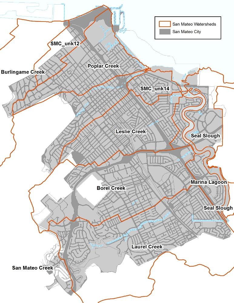
2 most useful data pertained to street width, sidewalk width, existing sidewalk planters, areas of damaged streets sidewalks that could be considered for future repair. San Mateo plans to capitalize on combining Green Infrastructure with multiple modes of transportation so the City wanted to include existing potential pedestrian paths (along with streets sidewalks) as potential GI locations. The City was most interested in identifying locations for bioretention features so this feature type was selected run through the various analyses. The City elected to include the Base Analysis in the Tool run. This analysis removes locations for consideration that don t meet the base criteria which can result in the exclusion of many locations that could be areas for GI but may need additional engineering. c2-1.png [1] Figure 2-1. Design guidelines for City of San Mateo street zones including planned zones for Green Infrastructure implementation (Courtesy of City of San Mateo). 2.2 Project setting In San Mateo, the GIS Site Locator Tool was demonstrated in five discrete watersheds including Borel Creek, Laurel Creek, Leslie Creek, Poplar Creek, San Mateo Creek, as well as multiple unnamed drainages (Figure 2-2). 2.3 Site Locator Tool: Data layers used decision process The GIS Site Locator Tool integrates regional local GIS data uses these data, through an
3 identification, ranking weighting process, to locate potential GI locations at a watershed scale. Data accuracy is an important determinant in the accuracy of map outputs produced by the Tool. The quality, scale accuracy of the input data will determine the quality, scale accuracy of the output maps. Therefore, it is highly beneficial to use more accurate local data when available. When using more regional scale data layers for analyses, such as the opportunities constraints ranking analysis, the user can weight rank these layers to reflect the confidence in local accuracy of the data. There are many regional GIS data that are included in the Tool (Table 2-1) additional regional data sets can be added as well. data sets can be added to the Tool in order to help identify potential locations that meet the goals planning needs of each city. Each municipality will identify a set of questions or goals to answer or meet prior to running the Tool. These questions or goals become the drivers for deciding which data sets to include. c2-2.png [2]
4
5 Figure 2-2. Map showing City of San Mateo watersheds drainage areas included in the demonstration project. Orange lines delineate each watershed boundary. Note that some watershed boundaries are outside the City. Table 2-1. GIS data layers included in the Site Locator Tool. GIS Data Layer Name GIS Data Layer Description CPAD_2014a2_Holdings California Protected Areas database released in the first half of 2014 FEMA_NFHL National Flood Hazard Layers for all BA counties Employment_Investment_areas_SCS From ABAG's data webpage From ABAG's data webpage. Priority Development Areas (Current) - This feature set contains changes made to Priority Priority Development Areas_Current Development Areas since the adoption of Plan Bay Area. DO NOT USE this feature set for mapping or analysis related to Plan Bay Area. K_12_Schools Schools in the bay area (point data) NLCD2011_PercentImpervious Percent Impervious data from the 2011 National L Cover Dataset OSM_Buildings OSM_Libraries OSM_Parking OSM_Parks OSM_Schools OSM_Streets R2_CARI_PublicV California Aquatic Resource Inventory for Region 2 _Bike_Facilities_Bay bike facilities for the Bay Area RWQC_RB_2 Region 2 Water Board Boundary For the city of San Mateo, the primary driver for implementing GI was the Sustainable Streets Plan. Since this plan focused on streetscape redevelopment, spatial data that quantified street sidewalk attributes integrated Complete Street concepts were important data for inclusion in the Tool. The City elected to run each of the Tool analyses including the Base Analysis. Primary locations identified by the City were public parks, pedestrian trails, wide streets, wide sidewalks, existing planters, parking lots. The city also identified planning opportunities such as areas planned for redevelopment (PDAs), areas of damaged streets/sidewalks, Greenway Networks, Bike Facilities as well as constraints to GI implementation including sidewalks with large
6 trees, fire lanes, narrow streets. These opportunities constraints were then categorized into factors such as funding opportunities, local development opportunities, community visibility, installation feasibility. These factors were then weighted to produce a relative ranking of areas for potential GI implementation, The City also included a data layer that identified City-owned parcels in the ownership analysis which allowed for a public/private delineation of locations in the map outputs. The last analysis removes areas that are not feasible GI locations such as wetls, riparian areas, areas with utility mains close to the surface. The City excluded all areas intersecting existing wetls the San Mateo Lagoon in this analysis. Table 2-2 shows the regional local GIS data layers included in the Site Locator Tool for the City of San Mateo. 2.5 Site Locator Tool Results Running the Site Locator Tool with the City of San Mateo was an iterative interactive process. The first round of conversations with the City focused on identifying street data that had spatial attributes for measuring existing street width. During subsequent conversations, additional data sets such as existing potential pedestrian trails, sidewalk width, areas of existing sidewalk planters, regional bike facilities in or identified as additional data that captured certain aspects of the Sustainable Streets Plan. This progression shows how GIS data layers can be added removed, rankings data layer weights can be changed. Additionally the Tool can be rerun by including or excluding any of the analyses. This iterative process can be refined as questions goals change or more accurate local data are available. Based on selected regional local data layers the City s ranking weighting of these layers, the Site Locator Tool identified 18 acres of City-owned property or right-of-way as highly ranked locations for potential GI implementation, 113 acres as moderately ranked, 11 acres as lower ranked locations (Figure 2-3). In total, 142 acres were identified as potential locations for Green Infrastructure. Higher ranked sites were the result of relatively higher factor weights on Priority Development Areas funding opportunity data layers. Table 2-2. regional GIS data layers included in the Site Locator Tool for the City of San Mateo. GIS Data Layer Name GIS Data Layer Description Data Layer Type Analysis Sidestreet parking Side Parking polygons on one lane streets (Where Width from Street Saver data* allowed for the minimum dimentions of lanes, medians parking spaces for each street type context from the San Mateo Sustainable Streets report) Sidestreet parking Side Parking polygons on one lane streets (Where There is no Width value from Street Saver data the minimum dimentions of all street comonants for each street type / context from the San Mateo Sustainable Streets report is assumed) Sidestreet parking Side Parking polygons on multi lane streets (Where Width from Street Saver data* allowed for the minimum dimentions of lanes, medians parking spaces for each street type context from the San Mateo Sustainable Streets report) / /
7 GIS Data Layer Name GIS Data Layer Description Data Layer Type Analysis Sidestreet parking Side Parking polygons on multi lane streets (Where There is no Width value from Street Saver data the minimum dimentions of all street comonants for each street type context from the San Mateo Sustainable Streets report is assumed) / Sidewalk Sidewalk Polygons (Where the width attribute from the San Mateo Sidewalk layer allows for the mimimum dimentions of sidewalk compoents for each street type context according to the San Mateo Sustainable Streets report allowed for a GI installation in the sidewalk furniture zone) Sidewalk Sidewalk Polygons (Where there is no width attibute from the San Mateo Sidewalk layer, minimum dimention of sidewalk compoents from the San Mateo Sustainable Streets report are assumed). Parking lot Parking Facilities quried from San Mateo's facility polygon layer Pedestrian Trails San Mateo's Pedestrian Trail layer buffered 2 ft on both sides (4 ft wide) Potential Pedestrian Trails San Mateo's Potential Pedestrian Trail layer buffered 2 ft on both sides (4 ft wide) Parking_OSM Parking polygons querried from SF Bay OSM polygons (downloaded in August 2014) Parks_OSM Park polygons querried from SF Bay OSM polygons (downloaded in August 2014) CPAD_Areas California Protect Areas Database Polygons for the Bay Area Sidewalk planter Sidewalk Polygons that have a planter width value of 4ft or more Sidewalk Sidewalk Polygons that have a width value of 8ft or more Priority Development Areas Bay Area Wide Priority Development Areas from ABAG Storm Line A 25 ft. buffer from the San Mateo Storm Line layer Storm Line A 50 ft. buffer from the San Mateo Storm Line layer Catch basin A 25 ft. buffer from the San Mateo Storm Catch Basin Layer
8 GIS Data Layer Name GIS Data Layer Description Data Layer Type Analysis Street Trees A 20 ft. buffer from the San Mateo Urban Tree layer large trees ( > 20) A 30ft buffer around trees that are over 20ft in circumference from the San Mateo Urban Tree layer Street Lights A 15ft buffer around street lights from the San Mateo Street Light layer (+5ft for spatial inacuracies between layers) Narrow Street_Fire Running Lanes A 40 ft. buffer from a selection from the San Mateo Fire Running Lane layer (streets that were less than or equal to 40 ft. wide accounting for spatial inaccuracies in the data layers used) Bike Facilities A 15 ft. buffer from the Bay Wide Bike Facilities Layer from MTC (+ 25ft to account for spacial inacuracies between layers) Streetside parking A Road polygon later create from San Mateo road centerlines buffered half width of that road (Street Saver data* width) taken from the San Mateo location street layer, where the width from Street Saver data* allows for the minimum width of street components for that particular street type context as well as the minimum width of a bike lane / Damaged Streets A Road polygon layer (San Mateo road centerline buffered by half of that street's width according to Street Saver data*) where PCI is less than or equal to 40, indicating that they are damaged roads may need to be repaired soon Damaged Sidewalk San Mateo Sidewalk polygons that are indicated as having damaged curbs, gutter or sidewalks GreenWay Network San Mateo pedestrian priority green way corridor from Ken Chen, Sep 2014 (buffered 85 feet to account for spatial inacuracies missalignment of layers.) Streams A 500ft buffer from a subset of San Mateo's Stream layer where no Streams intersect San Mateo's Lake layer Lakes A 400ft buffer from San Mateo's Lake polygon layer Schools A 100ft buffer from San Mateo's School polygon layer Libraries A 100ft buffer from San Mateo's Library polygon layer

9 GIS Data Layer Name GIS Data Layer Description Data Layer Type Analysis City Hall A 100ft buffer from City Hall polygons selected from San Mateo's Facility polygon layer parks A 100ft buffer from a subset of San Mateo's Facility polygon layer where FACTYPE is = to "PARK" City-owned parcels San Mateo's city owned parcel layer Ownership CARI Wetls CARI Wetl polygons: see [3] Knockout SM_Lagoon Lagoon Layer from San Mateo Knockout c2-3.png [4] Figure 2-3 Map output of ranked potential bioretention locations in the City of San Mateo. Higher ranked locations are dark blue, lowest ranked locations are red yellow designates unranked areas due to lacking data in those places
10 San Mateo SFEI performed a remote data validation exercise in order to see how the Tool ranked areas previously identified for potential GI implementation. Specifically, Grant Street Fremont Street were investigated to determine why one street ranked higher than the other. Grant Street was ranked higher than Fremont Street since it had a planned bike lane, which was given a higher weight in the Analysis. Delaware Street Bay Meadows were unranked in the output because they were excluded as possible locations due to site characteristics deemed not feasible for implementing GI. Overall, many of the sites identified ranked highly by the locator tool were also sites that were previously identified as potential GI opportunities by San Mateo. Furthermore, additional high ranked locations were identified which provided the City with additional locations to investigate further to compare to the current GI plan. Copyright 2015, San Francisco Estuary Institute - Aquatic Science Center Source URL (modified on Jun :59pm): Links [1] [2] [3] [4]
Getting Started On Your Green Infrastructure (GI) Plan
 Plan") Getting Started On Your Green Infrastructure (GI) Plan Peter Schultze-Allen EOA Inc. Annual SCVURPPP C3 Workshop June 16, 2015 Presentation Outline MRP 2.0 C.3.j (GI) requirements GI Framework elements
Getting Started On Your Green Infrastructure (GI) Plan Peter Schultze-Allen EOA Inc. Annual SCVURPPP C3 Workshop June 16, 2015 Presentation Outline MRP 2.0 C.3.j (GI) requirements GI Framework elements
Presentation Item C Annotated Model Outline for a Framework for a Green Infrastructure Plan
 Date: August 17, 2016 To: From: Subject: Management Committee Dan Cloak, Consultant Presentation Item C Annotated Model Outline for a Framework for a Green Infrastructure Plan Recommendation: Receive the
Green Streets. Sustainable Stormwater Solutions for Greener Communities and a Cleaner Bay
 Green Streets Sustainable Stormwater Solutions for Greener Communities and a Cleaner Bay As the Bay Area continues to grow through development of roads, revitalization of neighborhoods, and construction
Green Plan-IT Technical Advisory Committee Meeting Thursday December 15, 2016 A US EPA Region 9 WQIF Funded Project
 Green Plan-IT Technical Advisory Committee Meeting Thursday December 15, 2016 A US EPA Region 9 WQIF Funded Project In Attendance: Kristin Hathaway (City of Oakland), Keith Lichten (Regional Board), Jill
Potential Green Infrastructure Strategies May 6, 2015 Workshop
 Potential Green Infrastructure Strategies May 6, 2015 Workshop Background The City of Cortland is developing the Tioughnioga Urban Headwaters Green Infrastructure Action Plan with funding from the National
Appendix E: Illustrative Green Infrastructure Examples
 Appendix E: Illustrative Green Infrastructure Examples Integrating LID into San Francisco s Urban Landscape Figure E. High-density Residential Figure E. Low-density Residential Figure E. Mixed Use 7 Figure
San Mateo County Storm Water Resource Plan
 San Mateo County Storm Water Resource Plan Matthew Fabry, P.E. CASQA Effectiveness Assessment Sub-Committee November 16, 2016 SWRP RAA GI Plan Characterization of watersheds Stormwater Capture Model Web-based
NEORSD Green Infrastructure Grant (GIG) Program Opening Remarks
 Program Opening Remarks") NEORSD Green Infrastructure Grant (GIG) Program Opening Remarks 2019 NEORSD GIG Eligibility and Technical Requirements Project must be located in the Sewer District s combined sewer area Location Applicant
NEORSD Green Infrastructure Grant (GIG) Program Opening Remarks 2019 NEORSD GIG Eligibility and Technical Requirements Project must be located in the Sewer District s combined sewer area Location Applicant
Onondaga County Sustainable Streets Project. Onondaga County Planning Federation June 7, Onondaga County Sustainable Streets Project 1
 Onondaga County Sustainable Streets Project Onondaga County Planning Federation June 7, 2012 Onondaga County Sustainable Streets Project 1 Sustainable Streets 1. Introduction to the SMTC 2. Sustainable
Green Streets and Green Infrastructure Planning A Tale of Two Cities: San Mateo and Emeryville
 Green Streets and Green Infrastructure Planning A Tale of Two Cities: San Mateo and Emeryville SCVURPPP Annual C3 Workshop June 4, 2014 Peter Schultze-Allen, EOA Presentation Overview Goals/Incentives
Toronto Complete Streets Guidelines
 Toronto Complete Streets Guidelines 108 110 7.1 Green Infrastructure Design Principles 112 7.2 Context-Sensitive Green Streets 114 7.3 Key Green Street Elements Green infrastructure refers to natural and
COMPLETE GREEN STREET CHECKLIST
 COMPLETE GREEN STREET CHECKLIST This document was developed to dissect the structure of an urban street and explore opportunities to make our streets more complete while also integrating green street strategies.
MALLETTS BAY INITIATIVE
 MALLETTS BAY INITIATIVE Stormwater Management & Transportation Scoping Study January 19, 2017 Project Team Bryan Osborne Director of Public Works Sarah Hadd Director of Planning & Zoning Marshall Distel
Public Meeting May 20, 2014
 Public Meeting May 20, 2014 Overview Study Purpose Study Area Overview Strategies Potential Opportunities Implementation and Discussion Skeo Solutions Raleigh Walkable Watershed Pilot 2 Purpose Develop
PLANNED DEVELOPMENT (MASTER PLAN & UNIT PLAN)
") Central Permit Center 555 Santa Clara Street Vallejo CA 94590 Business License Building Fire Prevention Planning Public Works 707.648.4310 707.648.4374 707.648.4565 707.648.4326 707.651.7151 PLANNED DEVELOPMENT
Central Permit Center 555 Santa Clara Street Vallejo CA 94590 Business License Building Fire Prevention Planning Public Works 707.648.4310 707.648.4374 707.648.4565 707.648.4326 707.651.7151 PLANNED DEVELOPMENT
Conservation Corridor Base and Thematic Maps
 Conservation Corridor Base and Thematic Maps August 20, 2010 This project is funded in part by the Virginia Coastal Zone Management Program at the Department of Environmental Quality through Grant #NAO9NOS4190163
Implementation Guide Comprehensive Plan City of Allen
 Implementation Guide 2030 Comprehensive Plan City of Allen DRAFT 2015 Implementation Guide Allen 2030 Comprehensive Plan INTRODUCTION The Comprehensive Plan serves as a guide for the growth and development
Butchers Hill. Greening Feasibility FINAL REPORT MAY 2009 N PORT ST N WOLFE ST S MADEIRA ST. Submitted To: Submitted By:
 S WOLFE ST N CASTLE ST N WASHINGTON ST S WASHINGTON ST S CHAPEL ST S DURHAM ST S DUNCAN ST N MADEIRA ST N MONTFORD AVE Butchers Hill Greening Feasibility N DUNCAN ST MULLIKIN ST N PORT ST N WOLFE ST E
Planning & Designing for Green Infrastructure: Implementation in the Public Right-of-way
 Planning & Designing for Green Infrastructure: Implementation in the Public Right-of-way Presenters Terra Ishee, Acting Director, Pedestrian Projects Group, NYC DOT Rosanna Collars, Urban Planner & Designer,
A larger version of this map is located on the last page of this PDF.
 MAP Committee Input McLoughlin Area Draft Vision Map A larger version of this map is located on the last page of this PDF. 1. The map above is intended to portray a vision for the McLoughlin area. It highlights
The Art and Science of Stormwater Retrofitting
 The Art and Science of Stormwater Retrofitting April 9, 2008 Michael Novotney, Center for Watershed Protection Deb Caraco, Center for Watershed Protection Dan Frisbee, City of Charlottesville, Virginia
At first Work Session on October 22, At second Work Session on November 19, At third Work Session on December 3, 2015
 At first Work Session on October 22, 2015 Staff Reviewed Infrastructure: Transportation Capacity School Capacity Willett Branch Proposed Staging Language At second Work Session on November 19, 2015 Land
Reinventing Miner Avenue as a
 Reinventing Miner Avenue as a Complete Street Reinventing Miner Avenue as a Complete Street Agenda Project Overview / Introductions Previous Meeting Recap Economic Considerations Opportunities & Constraints
Melissa Bernardo Hess, PE, CFM February 18, 2016
 Using Green Infrastructure in Your MS4 Community Melissa Bernardo Hess, PE, CFM February 18, 2016 Today s Discussion What is Green Infrastructure? Why should I consider Green Infrastructure? What practices
3. VISION AND GOALS. Vision Statement. Goals, Objectives and Policies
 Vision Statement Queen Creek s interconnected network of parks, trails, open spaces and recreation opportunities provide safe and diverse activities and programs that sustain its unique, small town, equestrian
BASMAA Development Committee. Guidance for Identifying Green Infrastructure Potential in Municipal Capital Improvement Program Projects May 6, 2016
 Background BASMAA Development Committee Guidance for Identifying Green Infrastructure Potential in Municipal Capital Improvement Program s May 6, 2016 In the recently reissued Municipal Regional Stormwater
Ken Kortkamp, PE San Francisco Public Utilities Commission San Francisco, CA
 Ken Kortkamp, PE San Francisco Public Utilities Commission San Francisco, CA Development Process of San Francisco s GI Typical Details SCVURPPP GI Workshop April 19, 2017 Outline How to develop GI details
Working Group Meeting
 April 4,, 2017 Parks Operations Bldg Working Group Meeting Arts Districts Overview Stormwater/RPA/Stream Considerations First Principles Agenda 7:00pm 7:05pm 7:10pm 7:40pm 8:30pm 9:40pm 9:45pm Welcome
Asbury Chapel Subdivision Sketch Plan
 Asbury Chapel Subdivision Sketch Plan PART 1: PROJECT SUMMARY Applicant: NVR Inc. Project Size: +/- 76.13 acres Parcel Numbers: 02101112,02116101,02116112, 02116113 Current Zoning: Transitional Residential
PROP. 84 REMOVING BARRIERS TO LID: MUNICIPAL CODE UPDATE ASSISTANCE CASE STUDY: CODE UPDATES IN ARCATA
 PROP. 84 REMOVING BARRIERS TO LID: MUNICIPAL CODE UPDATE ASSISTANCE CASE STUDY: CODE UPDATES IN ARCATA OCTOBER 7, 2015 CASE STUDY: CODE UPDATES IN ARCATA Arcata is a city located in Humboldt County immediately
CHAPTER 8. Mrs. Zimman s Class - Central Elementary
 SUSTAINABILITY CHAPTER 8 Mrs. Zimman s Class - Central Elementary 8.1 OVERVIEW Green infrastructure also known as low impact development (LID) and environmental or sustainable site design is an environmentally
Outfall Retrofit Feasibility Study
 Outfall Retrofit Feasibility Study 2013 APWA-NC SWM Conference September 16-17, 2013 Overview PWD history with outfall retrofits Project setting Review of screening factors and weighting scale QA/QC process
BROOKHILL NEIGHBORHOOD MODEL ZONING MAP AMENDMENT PREFACE TO APPLICATION
 BROOKHILL NEIGHBORHOOD MODEL ZONING MAP AMENDMENT PREFACE TO APPLICATION June 15, 2015 Revised: August 1, 2016 I. VISION Brookhill is a proposed community based upon the principles of Albemarle County
A P P E N D I X D. Project Stormwater Plan Worksheets
 A P P E N D I X D Worksheets for Section 1: Basic Project Information This worksheet must be filled out for all projects required to implement the 2015 Post- Construction Stormwater Standards Manual. A
Overview of Southwestern Pennsylvania Commission s (SPC) 2040 Long Range Transportation Plan (LRTP)
 2040 Long Range Transportation Plan (LRTP)") Overview of Southwestern Pennsylvania Commission s (SPC) 2040 Long Range Transportation Plan (LRTP) Presented to Pennsylvania Agency Coordination Meeting May 27, 2015 Doug Smith & Ryan Gordon 1 Southwestern
Overview of Southwestern Pennsylvania Commission s (SPC) 2040 Long Range Transportation Plan (LRTP) Presented to Pennsylvania Agency Coordination Meeting May 27, 2015 Doug Smith & Ryan Gordon 1 Southwestern
Complete and Green Streets
 Complete and Green Streets DANNIELLE GLAROS CHIEF OF STAFF, COUNCILMAN ERIC OLSON JIM WILSON DEPARTMENT OF PUBLIC WORKS AND TRANSPORTATION, PRINCE GEORGE S COUNTY What is a complete street? Complete streets
Scope of Services. River Oaks Boulevard (SH 183) Corridor Master Plan
 Corridor Master Plan") Scope of Services River Oaks Boulevard (SH 183) Corridor Master Plan PROJECT AREA The project area consists of the River Oaks Boulevard (SH 183) corridor bounded by SH 199 at the northern end and the Trinity
Scope of Services River Oaks Boulevard (SH 183) Corridor Master Plan PROJECT AREA The project area consists of the River Oaks Boulevard (SH 183) corridor bounded by SH 199 at the northern end and the Trinity
Complete Streets in Lancaster County
 Complete Streets in Lancaster County PRESENTED BY: Robert Bini, AICP Director for Transportation Planning November 14, 2017 Lancaster County is a growing county of over 534,000 and the bottom line is...
Green Infrastructure for Municipalities in New York s Lake Champlain Basin
 Green Infrastructure for Municipalities in New York s Lake Champlain Basin Building Development Manual Download If you haven t already, download the manual: http://www.lcbp.org/2017/05/green-infrastructure-webinarseries/
Swan Creek Urban BMP Inventory and Assessment. Jeff Grabarkiewicz, Kari Gerwin, Ann-Drea Hensley TMACOG, Lucas SWCD/Engineers, and Partners
 Swan Creek Urban BMP Inventory and Assessment Jeff Grabarkiewicz, Kari Gerwin, Ann-Drea Hensley TMACOG, Lucas SWCD/Engineers, and Partners Presentation Outline Project Background Methods Inventory Desktop
EXISTING PLANS Harriet Festing Center for Neighborhood Technology Midlothian Community Meeting March 12, 2015
 EXISTING PLANS Harriet Festing Center for Neighborhood Technology Midlothian Community Meeting March 12, 2015 BENEFITS Bring economic, community + environmental benefits Enhance property values Use
RECREATION AND OPEN SPACE ELEMENT GOALS, OBJECTIVES, AND POLICIES
 RECREATION AND OPEN SPACE ELEMENT GOALS, OBJECTIVES, AND POLICIES Goal 7 To provide park facilities, recreation programs, and open space resources that are safe, adequate, and accessible to all City residents,
Atlanta BeltLine Subarea 3 Master Plan Update
 Atlanta BeltLine Subarea 3 Master Plan Update April 14, 2018 Workshop Meeting 1 22 miles, connecting 45 neighborhoods 22 MILES of transit 46 MILES of streetscapes and complete streets 33 MILES of urban
Outflow to Saw Mill Run
 Dormont Stormwater Fee Frequently Asked Questions What is stormwater, and why is it a problem in Dormont? Stormwater is runoff from rain or snow that falls and flows to Little Saw Mill Run or McNeilly
Richton Park Western Development Corridor Green Infrastructure Development Plan August 18, 2017
 Richton Park Western Development Corridor Green Infrastructure Development Plan August 18, 2017 Conservation Design Forum Geosyntec Consultants 403 W. St. Charles Road 1420 Kensington Road, Suite 103 Lombard,
CONCEPT PLAN APPLICATION
 CONCEPT PLAN APPLICATION TOWN OF CHAPEL HILL Planning Department 405 Martin Luther King Jr. Blvd phone (919) 968-2728 fa (919) 969-2014 www.townofchapelhill.org Parcel Identifier Number (PIN): 9880267455
The transportation system in a community is an
 7 TRANSPORTATION The transportation system in a community is an important factor contributing to the quality of life of the residents. Without a sound transportation system to bring both goods and patrons
ESTABLISH AN EFFICIENT TOWN CENTER
 ESTABLISH AN EFFICIENT TOWN CENTER 4 Overview Lisbon residents are proud of the history of Newent and at the same time recognize its current importance as a centralized location for a variety of municipal
San Francisco Bay Pilot: Sausal Creek Community Leader Charrette May 11, 2016 Marcus Griswold
 San Francisco Bay Pilot: Sausal Creek Community Leader Charrette May 11, 2016 Marcus Griswold 1 Overview Project Overview Watershed Context Assets and Challenges Opportunities Green Streets Creek Access
City of Hermosa Beach Administrative Policy #
 City of Hermosa Beach Administrative Policy # SUBJECT: Living Streets Policy Date: Approved by: City Council Authority: Public Works Department & Community Development Department Mayor, PURPOSE The City
Re: Application Type: Proposed Highlands Redevelopment Area Designation
 CHRIS CHRISTIE Governor KIM GUADAGNO Lt. Governor State of New Jersey Highlands Water Protection and Planning Council 100 North Road (Route 513) Chester, New Jersey 07930-2322 (908) 879-6737 (908) 879-4205
Tennessee Stormwater Management Program. Stormwater Management Site Assessment and Inventory Checklist. Quick Check o Vicinity Map within Watershed
 Tennessee Stormwater Management Program Project Name: Location: File Number: Reviewer: Date of Submittal: Review Date: Project Meeting Chronology: Type of Meeting: Date: Stormwater Management Site Assessment
Post-Construction Stormwater Management Checklist* (5,000 SF or Greater)
") Applicability: Required for projects that create and/or replace 5,000 square feet or greater of impervious surface (i.e. asphalt roads, concrete structures, building area, sidewalks, etc.). Impervious
Applicability: Required for projects that create and/or replace 5,000 square feet or greater of impervious surface (i.e. asphalt roads, concrete structures, building area, sidewalks, etc.). Impervious
Bostwick Road. Municipal Class Environmental Assessment. Public Information Centre #2 June 14, City of London
 Bostwick Road Municipal Class Environmental Assessment Public Information Centre #2 June 14, 2017 Welcome! Welcome to the 2 nd Public Information Centre for the. Representatives from the and the consulting
CHAPTER 8 ISSUES, CONCERNS, CONSTRAINTS AND OPPORTUNITIES
 CHAPTER 8 ISSUES, CONCERNS, CONSTRAINTS AND OPPORTUNITIES Introduction This River Conservation Plan was developed during a time of tremendous activity and effort in planning the transformation of the Delaware
Green Stormwater Infrastructure Handbook. Kristin Kerr, P.E. EOA / SCVURPPP November 29, 2018
 Green Stormwater Infrastructure Handbook Kristin Kerr, P.E. EOA / SCVURPPP November 29, 2018 Outline of Presentation Overview Handbook Contents Example Details Overview MRP requires GSI Plans to include
Provide and maintain sufficient public parks, recreation facilities, and open space to meet the recreational needs of County residents and visitors.
 (ROS) Goal Provide and maintain sufficient public parks, recreation facilities, and open space to meet the recreational needs of County residents and visitors. OBJECTIVE ROS.01 The County shall acquire,
Olde Towne Vision Plan
 Olde Towne Vision Plan Introduction In 2016, the City of Bellevue will complete its move of City offices from Olde Towne Bellevue to its new municipal complex on Wall Street. The City intends to sell its
ARTICLE 6: Special and Planned Development Districts
 ARTICLE 6: Special and Planned Development Districts 6-10 Traditional Neighborhood Development (TND) District 6-10.10 Purpose and Intent The Traditional Neighborhood Development (TND) District provides
The Benefits and Challenges Associated with Green Infrastructure Practices
 The Benefits and Challenges Associated with Green Infrastructure Practices Thomas M. Evans ASLA, LEED AP Regional Green Infrastructure Design Services Director OWEA Technical Conference, June 20, 2013
PART 1: PROJECT SUMMARY. Proposed Land Use: 120 single-family lots. The application is Attachment A. The site plan is Attachment B.
 PART 1: PROJECT SUMMARY Applicant: JBH Development, LLC and Hopper Communities, INC Project Size: +/- 80.48 acres Parcel Number: 01513107, 01513108, 01513109, 01513113, 01513120, 01513121, 01513122, 01513124,
Project Applicant Checklist for NPDES Permit Requirements SAN MATEO COUNTYWIDE STORMWATER POLLUTION PREVENTION PROGRAM
 Project Applicant Checklist for NPDES Permit Requirements SAN MATEO COUNTYWIDE STORMWATER POLLUTION PREVENTION PROGRAM I. PROJECT DATA Project Name Bay Meadows Development Phase II Project Address 2600
The Illinois Department of Transportation and Lake County Division of Transportation. Route 173, including the Millburn Bypass
 The Illinois Department of Transportation and Lake County Division of Transportation welcome you to this Public Hearing for U.S. Route 45 from Illinois Route 132 to Illinois Route 173, including the Millburn
TENTATIVE MAP CHECKLIST
 Business License 707.648.4357 www.cityofvallejo.net Central Permit Center 555 Santa Clara Street Vallejo CA 94590 Building 707.648.4374 Planning 707.648.4326 TENTATIVE MAP CHECKLIST Public Works/Engineering
Regional Context Statement
 Regional Context Statement REGIONAL CONTEXT STATEMENT 3. REGIONAL CONTEXT STATEMENT In 1995, the Provincial Government passed into law the Growth Strategies Act. The purpose of this provincial initiative
Figure 1 SSIP Watersheds (Source: SFPUC) North Shore Watershed
 North Shore Watershed") LOVE AND HAIGHT - GREENING THE STREETS OF SAN FRANCISCO Thomas M. Sweet, PE, LEED AP BD+C Senior Engineer, AECOM, San Francisco Amir Ehsaei, PhD Project Engineer, AECOM, San Francisco Purpose: Case study
LOVE AND HAIGHT - GREENING THE STREETS OF SAN FRANCISCO Thomas M. Sweet, PE, LEED AP BD+C Senior Engineer, AECOM, San Francisco Amir Ehsaei, PhD Project Engineer, AECOM, San Francisco Purpose: Case study
When planning stormwater management facilities, the following principles shall be applied where possible.
 2.0 Principles When planning stormwater management facilities, the following principles shall be applied where possible. 2.0.1 Drainage is a regional phenomenon that does not respect the boundaries between
SECTION II SECTION II STATEMENT OF GOALS, OBJECTIVES, PRINCIPLES, ASSUMPTIONS, POLICIES AND STANDARDS
 STATEMENT OF GOALS, OBJECTIVES, PRINCIPLES, ASSUMPTIONS, POLICIES AND STANDARDS 1 2 STATEMENT OF GOALS, OBJECTIVES, PRINCIPLES, ASSUMPTIONS, POLICIES AND STANDARDS INTRODUCTION The New Jersey Municipal
Metropolitan Area Planning Council 60 Temple Place, Boston, Massachusetts fax
 Metropolitan Area Planning Council 60 Temple Place, Boston, Massachusetts 02111 617-451-2770 fax 614-482-7185 www.mapc.org Serving the 101 Cities and Towns in the Metropolitan Boston Region MEMORANDUM
Study Area. Capitol Way. Greening America s Capitals 11/13/2014. A Greening America s Capitals Project
 Olympia, WA: Greening Capitol Way Supporting Communities move towards sustainability is a priority for the federal government. A Greening America s Capitals Project Office of Sustainable Communities U.S.
Chapter 6. Green Streets
 Chapter 6. Green Streets Description Green streets are designed in a holistic manner that minimizes impervious surfaces, emphasizes landscaped elements, includes measures for enhancing water quality, while
Silverdale Regional Center
 Silverdale Regional Center Vision for Silverdale Regional Center The Silverdale Regional Center Plan (Plan) will guide the evolution of the Silverdale Regional Center from a collection of strip malls and
water that enters our streams during storms. Any water the rain garden can t accept will continue into the storm sewer system.
 North Kensington Street and 32 nd Street North Green Street and Sewer Capacity Meeting Friday, July 20 and Monday, July 23, 2012 Summary of Citizen Questions and Concerns Thank you for participating in
Commercial Node Plan Devine Street/Jackson Blvd. COLUMBIA, SC
 Commercial Node Plan Devine Street/Jackson Blvd. COLUMBIA, SC 9.17.13 AGENDA 1 Introductions 2 Project Update 3 Concepts 4 Recommendations 5 Next Steps Introductions Project Update Process 5-Phase Process
Chapter 3 Site Planning and Low Impact Development
 CHAPTER 3 Site Planning and Low Impact Development Chapter 3 Site Planning and Low Impact Development 3.0 Introduction The City of Charleston requires that major residential, large commercial (>1 acre),
Watershed Planning Workshop
 Watershed Planning Workshop Upper Four Mile Run, Gulf Branch and Donaldson Run March 18, 2010 Langston Brown Community Center Outline Overview of Arlington s s Watersheds Watershed Management in Arlington
STORMWATER UTILITY FREQUENTLY ASKED QUESTIONS
 STORMWATER UTILITY FREQUENTLY ASKED QUESTIONS What is Stormwater? Stormwater is water that falls to the ground during a precipitation event. When land is undeveloped or covered with vegetative surface,
Regional Open Space Conservation Plan. Regional Staff Committee January 18, 2018
 Regional Open Space Conservation Plan Regional Staff Committee January 18, 2018 Schedule We are here Task 1 - Stakeholder Input & Work Plan Dev. v z 2016 2017 2018 Oct Nov Dec Jan Feb Mar Apr May Jun Jul
The desired completed design will create a green street out of Buchanan Street in Mount Rainier.
 Buchanan Green Street Project Abstract: The Buchanan Green Street project in Mount Rainier will reduce pollution of the Chesapeake Bay by filtering polluted stormwater before it reaches the Northwest Branch
St. Clair Avenue West Area Transportation Master Plan
 1 (Between Keele Street and Old Weston Road) Public Information Centre 1 December 2, 2015 2 Welcome Welcome to the first Public Information Centre for the St. Clair Avenue West Area. The panels will present
GREEN STORMWATER INFRASTRUCTURE (GSI) Planning Guidelines
 Planning Guidelines") GREEN STORMWATER INFRASTRUCTURE (GSI) Planning Guidelines Last Updated: June 2015 The purpose of this document is to outline the department s standard workflow for GSI planning and analysis. This packet
GREEN STORMWATER INFRASTRUCTURE (GSI) Planning Guidelines Last Updated: June 2015 The purpose of this document is to outline the department s standard workflow for GSI planning and analysis. This packet
3. Are there any projects exempt from the definition of Regulated Projects?
 STORMWATER REQUIREMENTS: OVERVIEW OF PROVISION C.3 Background: On October 14, 2009, the Regional Water Quality Control Board, San Francisco Bay Region, issued a municipal regional stormwater permit (MRP)
City of Yelm. Tahoma Terra Final Master Plan Development Guidelines. Table of Contents
 City of Yelm Tahoma Terra Final Master Plan Development Guidelines Table of Contents Table of Contents... 1 Purpose... 2 Low Density Residential (R4-6)... 3 Moderate Density Residential (R6-10)... 5 Neighborhood
BMP Siting Tool. Step-by-Step Guide
 BMP Siting Tool Step-by-Step Guide ArcGIS 10.1 Service Pack 1 (Build 3143) Prepared by: Tetra Tech, Inc. 10306 Eaton Place, Suite 340 Fairfax, VA 22030 January 2013 Contents 1 Getting Started... 1 1.1
Can Urban Redevelopment Restore Aquatic Resources
 Can Urban Redevelopment Restore Aquatic Resources with Standards for Stormwater Retention and Landscape Performance? Rebecca C. Stack District of Columbia Department of the Environment Industry, Agriculture,
SCVURPPP Green Infrastructure Handbook. Kristin Kerr, P.E. EOA, Inc. April 19, 2017
 SCVURPPP Green Infrastructure Handbook Kristin Kerr, P.E. EOA, Inc. April 19, 2017 Outline of Presentation Overview Handbook Contents Schedule Overview MRP requires GI Plans to include general guidelines,
Secrest Short Cut and Monroe Expressway Small Area Plan AUGUST 29, 2018
 Secrest Short Cut and Monroe Expressway Small Area Plan AUGUST 29, 2018 Background and Process Monroe Expressway will be open by the end of 2018 Union County and Indian Trail identified a need to revisit
The Green Infrastructure Plan Requirement: shifting from gray to green infrastructure June 14, 2016
 The Green Infrastructure Plan Requirement: shifting from gray to green infrastructure June 14, 2016 Connie Goldade Community Design + Architecture Green Infrastructure (GI) Requirements Develop a Green
Town of Peru Comprehensive Plan Executive Summary
 Town of Peru Comprehensive Plan Executive Communities that plan grow by choice, not by chance. A plan makes growth thoughtful, understandable, and predictable. A plan shows that a community is managing
TABLE OF CONTENTS. Transportation Chapter 1 - Introduction and Purpose of Planning to 1-3. Utilities
 Chapter 1 - Introduction and Purpose of Planning... 1-1 to 1-3 Pennsylvania Municipalities Planning Code (Act 247)...1-1 Previous County Planning Activities...1-1 Objectives of the Plan...1-2 Elements
Neighborhood-Scale Water Quality Improvements The Broadway Neighborhood Stormwater Greenway Project
 Neighborhood-Scale Water Quality Improvements The Broadway Neighborhood Stormwater Greenway Project Presenter: Stacy Luell, Geosyntec Consultants Co-Authors: R. Batchelder, W. Tam, M. Hanna, M. Sadeghi
People who are members of historically disenfranchised racial, ethnic, cultural, and other identity groups are encouraged to apply.
 CALL TO ARTISTS REQUEST FOR QUALIFICATIONS CITY OF TACOMA MUNICIPAL ART PROGRAM East 64 th Streetscape, Tacoma, WA APPLICATION DEADLINE October 10, 2018, 11:59pm BUDGET $72,000, all-inclusive SUMMARY The
Ten Mile Creek Planning Area
 PLANNING AREA POLICIES TEN MILE CREEK Ten Mile Creek Planning Area Location and Context The Ten Mile Creek Planning Area ( Ten Mile Creek area ) is located south of the current Boise AOCI, generally south
Green Infrastructure. by Karen Engel, NYS DEC. NYS Department of Environmental Conservation
 Green Infrastructure by Karen Engel, NYS DEC What is Green Infrastructure? For some it s all about water Green Infrastructure techniques use soils and vegetation to infiltrate, evapotranspirate, and/or
City of Heath. Town Center Concept
 In the give-and-take of getting projects designed, financed, and approved, the famous refrain from the film Field of Dreams is heard often: if you build it, they will come. From the perspective of the
Bruce Adams, Waste Water Treatment Plant Operations Manager, City of Cortland Chris Bistochi, Public Works Director, City of Cortland
 MEMORANDUM (DRAFT) Date: January 14, 2014 To: Mack Cook, Director of Administration and Finance, City of Cortland Chris Bistochi, Director of Public Works Department, City of Cortland Amanda Barber, Cortland
AMENDMENT NO. 30 TO THE OFFICIAL PLAN OF THE TOWN OF MILTON
 AMENDMENT NO. 30 TO THE OFFICIAL PLAN OF THE TOWN OF MILTON Subject: Boyne Survey Secondary Plan and Related Official Plan Amendments The following text and schedules constitute Amendment No. 30 to the
Notice of Preparation of an Environmental Impact Report and Scoping Meeting for the Canyon Lane Roadway Improvements Development Project
 of an Environmental Impact Report and Scoping Meeting for the As the Lead Agency, the County of San Mateo (County) will prepare an Environmental Impact Report (EIR) for the (project), and would like your
Major Subdivision Sketch Plan Checklist
 This checklist provides specific requirements that are apart of the Sketch process. The entire process is described by the Huntersville Subdivision Review Process which details all the submittal and resubmittal
A BLUEPRINT FOR BROCKTON A CITY-WIDE COMPREHENSIVE PLAN
 A BLUEPRINT FOR BROCKTON A CITY-WIDE COMPREHENSIVE PLAN Public Meeting October 2016 1 Plan Summary and Discussion Public Meeting May 4 2017 City of Brockton Bill Carpenter, Mayor Department of Planning