EXTENDING THE ACADEMIC CAMPUS University Street Feasibility Study
|
|
|
- Kevin Lynch
- 5 years ago
- Views:
Transcription

1 EXTENDING THE ACADEMIC CAMPUS University Street Feasibility Study MARCH 2012
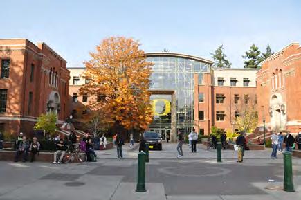
2 THE OREGON CAMPUS The physical character of the American campus stems from a romantic idea with a Latin root. In contrast with the cloisters and dense urban conditions of European colleges, the American university locates the place of higher learning in a field (campus), emphasizing spaciousness and openness to the world by placing separate buildings among open space. 1 Over time, this physical identity expanded to encompass a university s larger educational ideals and even its community as a whole. Today, when speaking of campus, one is referring to a unique set of physical and intellectual ideals that define higher education in a particular place. At the University of Oregon, this American tradition is carried forward in campus planning that emphasizes the development of a designated open space framework within which academic buildings and a network of campus paths are interlaced. The formal structure of campus open space communicates the significance of particular academic buildings and the heritage of the university. 1 Campus: An American Planning Tradition by Paul Venable Turner (1987)

3 TABLE OF CONTENTS 1 EXECUTIVE SUMMARY Overview Proposed Framework Planning Background 2 PROGRAM ANALYSIS Program Summary Synergies & Requirements 3 SITE CONTEXT Preliminary Site Analysis Campus Plan Summary 4 EXTENDING CAMPUS : PROPOSED FRAMEWORK Open Space Framework Transportation Network Key Patterns Density Comparisons 5 DESIGN PROCESS 6 CONCLUSION PROJECT TEAM John Rowell, Principal Kaarin Knudson, Designer / Project Manager Lorri Nelson, Landscape Architect Eleni Tsivitzi, Designer MARCH 2012 PROPOSED UNIVERSITY AXIS
, the Office of the Registrar, Department of Human Physiology, and School of Architecture & Allied Arts (A&AA).")
4 EXECUTIVE SUMMARY ERB MEMORIAL UNION FRAMEWORK ELEMENTS STUDY AREA PROGRAM This study includes approximately 750,000 GSF to accommodate the collective program of the Student Recreation Center (SRC), Physical Education and Recreation (PE/Rec), the Office of the Registrar, Department of Human Physiology, and School of Architecture & Allied Arts (A&AA). LIBRARY AXIS GERLINGER ENTRANCE GREEN STRAUB GREEN STRAUB HALL DESIGNATED OPEN SPACE The University Street Axis is transformed from a high-speed parking lot into a gateway axis and multi-modal mall. This axis reaches the full length of campus and transitions in character from a local city street to campus green space. It includes a designated bike path, wide campus paths, plazas, green space, bike parking, a roundabout to redirect vehicle traffic away from the campus core, and emergency access. New designated open space is also established at Esslinger Green, South Green, Fields Axis, and an extension of the 17th Avenue Axis. GERLINGER GREEN UNIVERSITY AXIS 130,000 GSF 15TH AVENUE AXIS STUDENT REC CENTER WITH 2012 EXPANSION ESSLINGER GREEN UNIVERSITY OVERLOOK In front of the Mac Court site, University Hill rises to its highest point and provides a dramatic view into and from campus. A bosc of trees and plaza are proposed to mark this highly visible and scenic threshold. FIELDS AXIS IDENTITY BUILDINGS Three locations along the new University Axis are considered primary identity-giving building sites. The prominence of buildings in these locations will have a strong influence over the character of campus in this precinct. PIONEER CEMETERY 160,000 GSF 17TH AVENUE AXIS STUDENT TENNIS CENTER SOUTH GREEN CAMPUS GATEWAYS At 18th and University Street, a forecourt of green space leading to a new campusscale building and a pedestrian-oriented streetscape project a strong sense of the University s identity along this edge of campus. At the top of University Hill, another gateway is formed. 90,000 GSF 70,000 GSF 18TH AVENUE ONYX 2 Rowell Brokaw Architects University Street Feasibility Study
5 EXECUTIVE SUMMARY OVERVIEW In September 2011, Rowell Brokaw Architects was asked to study the area of campus currently occupied by Esslinger Hall, McArthur Court, Howe Field, and the Outdoor Program Trip Facility essentially 15th to 18th Avenues along University Street. The purpose of this work was to assess the capacity of the Study Area, and to test the feasibility of locating the following program groups on the site: the Student Recreation Center (with proposed 2012 expansion), PE/Rec Department, the Department of Human Physiology, Registrar s Office (general classrooms), and the School of Architecture & Allied Arts. In total, this collective program requires nearly 750,00 GSF. This study s findings directly support the basic principles of campus planning and the Campus Plan s discussion of Historic Landscapes. The Campus Plan describes how designated open space and academic buildings working together give form and character to the extraordinary place that is the University campus. This study shows how the characteristics of the historic campus core can provide a model for campus expansion and redevelopment, particularly in a superblock that has developed without the structure of an underlying street grid. CONCLUSIONS The collective program can be accommodated on the site with the development of a strong open space framework and amendments to the Campus Plan. The primary synergy among the program groups is strong campus open space. This also supports the programs uniform desire for increased visibility on campus. The transformation of the University Street Axis into a primary campus green space is essential to the extension of university s academic character to this site. Such a transformation will prioritize bicycle and pedestrian traffic while allowing for service vehicles, emergency access, and approximately 400 below-grade parking spaces. Substantial changes to the transportation framework are needed to implement the open space proposal and to improve bicycle and pedestrian access. These changes will strengthen the campus as a whole and can be phased over time. If the principles of the Campus Plan are applied, and high-quality designated open space is created, the Study Area has the capacity for greater development density than the Campus Plan currently allows. The proposed FAR would increase the Study Area from the lowest density on campus to one of the most dense areas. This highly visible campus gateway can be dramatically improved with the development of strong campus open space, paths, and new construction. Such improvements would transform the campus experience from 18th Avenue to the Heart of Campus, and strengthen the connection between the East Campus and Southwest Campus as well. Rowell Brokaw Architects University Street Feasibility Study 3
 Existing Fire Lane Access Existing Fire Lane Access UNIVERSITY STREET STUDY")
6 Existing Fire Lane Access STUDENT RECREATION CENTER (PERIMETER OF EXISTING SRC AND 2012 EXPANSION) MCARTHUR COURT STUDENT TENNIS COMPLEX (SRC EXPANSION SITE) Existing Fire Lane Access Existing Fire Lane Access UNIVERSITY STREET STUDY AREA 4
7 EXECUTIVE SUMMARY PROJECT SCOPE While previous studies have looked at the feasibility of locating individual programs in the Study Area, this study was the first to integrate all of the program groups and study the larger site. Specifically, Rowell Brokaw Architects was asked to: Include recommendations that extend the character of the campus core to this site; Build on past studies; Engage in a dialogue with the program groups and study potential synergies; Assess the site s carrying capacity; Propose a redevelopment framework that can accommodate the program while following the principles of the Campus Plan; and Establish a visual and analytic framework to guide planning for the redevelopment of this area. PROJECT PARAMETERS The Study Area was focused along University Street from 15th to 18th Avenues, including the Esslinger Hall, McArthur Court, and Howe Field sites. The study was asked to address the combined program of the Student Rec Center (with 2012 expansion), PE/Rec Department, the Department of Human Physiology, Registrar s Office (general classrooms), and the School of Architecture & Allied Arts. The Student Rec Center (SRC) was presumed expand its current footprint to areas currently occupied by the covered tennis courts and service alley. The re-use of McArthur Court needed to be accommodated in at least one option. With new development south of McArthur Court, Howe Field would be relocated. While 15th Avenue plays a key role in the transportation network serving this area, it was not a focus of this study. Observations of existing conditions, opportunities, and desired paths were noted and included in the proposed framework. Pioneer Cemetery is not owned by the University and no direct proposals for its modification were included in this study. However, opportunities and challenges were noted in this report and the proposed framework. PROJECT SCHEDULE Preliminary meetings and interviews with the with the program groups and representatives were held in September A presentation of possible program synergies was held in late October 2011 and, in December 2011, a pair of preliminary design alternatives were presented to the program group representatives. A final proposed framework was then developed and presented in an open meeting with faculty and staff from each program group in February Following this meeting, the final report was released as a draft, and then finalized. Rowell Brokaw Architects University Street Feasibility Study 5
.")

8 Views of Campus and the Study Area, outlined in yellow dashed line, in 1930 (top) and 1950 (below). The images show the absence of an underlying street structure and campus open space in the Design Area F superblock. Nearby, Emerald and Onyx Streets provide precedent for streets transforming into campus green space. EMERALD STREET ONYX STREET UNIVERSITY STREET 6
9 EXECUTIVE SUMMARY PLANNING BACKGROUND Aerial photos dating back to the early 20th century show the absence of City street structure or alleyways from Design Area F, and its historic use for recreation and athletics dates to the construction of Hayward Field in Esslinger Hall was constructed in 1936, as the new home of the University s Physical Education department, one of the first in the nation. It was not until 2007 that academic uses were proposed for this Design Area. Before 2012, University had pursued several initiatives related to facilities and programs within this Study Area, including: Expansion and renovations of the Student Recreation Center (SRC). The SRC was opened in 1999 in a combination of new and existing structures including parts of the ground floor of Esslinger Hall. Slated for expansion and renovation within the next few years, and to be funded by a combination of student fees and private donations, the project will result in a facility which has expanded and improved capacity for students and their recreational needs. A conceptual study was completed in Schematic design was underway in fall 2011, concurrent with this study. Redevelopment of Esslinger Hall to include University Classrooms, spaces for the Department of Human Physiology, and the Student Recreation Center. A conceptual study for the redevelopment of Esslinger Hall was completed in spring 2011 by Yost Grube Hall Architects. Adaptive Re-use of McArthur Court. A study was completed in spring 2010 by SERA Architects to determine the technical feasibility of renovating McArthur Court for use by the School of Architecture & Allied Arts. Following this study, the School of Architecture & Allied selected this area of campus including McArthur Court and the land to the south as their preferred location for a new A&AA complex. Broader studies, including the 2005 Campus Plan and the 2001 University Street Study, contain observations about the use of this particular area of campus. Rowell Brokaw Architects University Street Feasibility Study 7

10 PROGRAM ANALYSIS COLLECTIVE PROGRAM PE/Rec/SRC and A&AA are two of the largest, most populated programs on campus. Human Physiology is currently the fastest growing department on campus. Collectively, the four programs proposed for this site total nearly 750,000 GSF of interior space, and this area is split nearly evenly into two parts: the PE/Rec, Human Physiology and SRC programs and the space needed to house A&AA departments. 8 Rowell Brokaw Architects University Street Feasibility Study
11 PROGRAM ANALYSIS PROGRAM SUMMARY Early discussions and on-going meetings with the Department of Human Physiology, PE/Rec and the Student Recreation Center, and the School of Architecture & Allied Arts informed the process and outcomes of this study. Individual meetings and discussions with representatives from these programs at critical points in the design process were key to the understanding of potential program synergies, and the development of preliminary alternatives and the final proposal. HUMAN PHYSIOLOGY Interviews with representatives from Human Physiology identified two primary objectives in planning for new facilities: Consolidation to allow for collaboration among faculty / core program (40,000 SF) and the capacity to accommodate the department s rapid growth and growing identity on campus. Other issues raised during discussions included: The department s heritage connection to PE/Rec, which dates back to the UO s pioneering Department of Physical Education established in 1922; A core belief shared with Physical Education that physical activity is good for people and an important part of healthy lives; Human Physiology is the science/future side; PE is the life skills/activity side; Some academic interface with Athletics uses; The Health Campus Initiative is seen as opportunity to connect theory and practice as it relates to the human body and performance. The total space need for Human Physiology is projected to be 75,000 SF. The core program is composed of approximately 40,000 SF of labs and office space that would allow for the consolidation of faculty in one location on campus. The remaining 35,000 SF of administrative and classroom spaces are considered an important second priority. PHYSICAL EDUCATION (PE/REC) + STUDENT RECREATION CENTER (SRC) The program for the UO Student Recreation Center includes 241,000 SF, of which approximately 1/2 is currently located in Esslinger Hall. Administrative offices for PE/ Rec require an additional 14,000 SF, bringing the total program for PE/Rec and the SRC to 255,000 SF. With the schematic design, the SRC program had been expanded to 270,000 SF, with no renovations included. The expansion project identified five inter-related must-do priorities: Improved wayfinding New aquatics facility / natatorium New 3-court gym Double the existing cardio/weight space (goal: 1 SF per student enrolled) New multipurpose spaces for activities and PE use Rowell Brokaw Architects University Street Feasibility Study 9
12 PROGRAM ANALYSIS Interviews with representatives from PE/Rec also identified the need for adequate acoustic separation of PE/Rec uses from classroom or research space, and the desire for increased visibility for PE administration. While a more direct connection between the SRC and PE/Rec administration is also desirable, program representatives noted that it was not considered necessary for the PE/Rec uses currently accommodated within Esslinger Hall to remain in the Esslinger footprint. The focus of the 2012 SRC project is expansion of recreation facilities, not the renovation of existing space or creation of new space for campus initiatives. The 5,000 SF Healthy Campus Initiative is not included in the 2012 SRC expansion, but it is one of the clearest points of synergy between the PE/Rec and Human Physiology departments. REGISTRAR S OFFICE - GENERAL UNIVERSITY CLASSROOMS A new 500-seat general classroom and four 60- to 80-seat classrooms are also included in the required program. These classrooms would serve the University as a whole, and the 500-seat classroom would likely be located within a 10-minute walking circle of the campus center. The area for these new classrooms is 20,000 SF. SCHOOL OF ARCHITECTURE & ALLIED ARTS (A&AA) The School of Architecture & Allied Arts includes nine interdisciplinary programs that total approximately 340,000 GSF, based on a 2009 preliminary space need study. Interviews with A&AA representatives revealed a clear priority to expose the inquiry of A&AA with the development of a new complex. There was a strong desire to create a contemporary space for the school s workshop- and studio-based environments, while also connecting to heritage of campus viewsheds. The A&AA combines a professional school with humanities studies and academic research, and would representatives requested spaces to support exploration in both flexible think-tanks and fabrication laboratories. Preliminary discussions broached the potential to rethink existing separations among departments and seize the opportunities and efficiencies that a unified A&AA campus would present. While additional refinement of the proposed space needs assessment was requested, the idea of an interconnected complex of buildings that forms layers of indoor and outdoor space was a recurring theme. Unlike the Esslinger Hall study completed for SRC, PE/Rec and Human Physiology, the conceptual work to date for A&AA does not include an architectural diagram of how spaces and departments might inter-relate. In the absence of such information, assumptions were made as to how programs might be mixed to support collaboration while maintaining legible identities within the school. 10 Rowell Brokaw Architects University Street Feasibility Study
.")

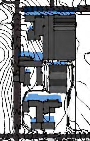
. Dark green represents designated campus green space.")
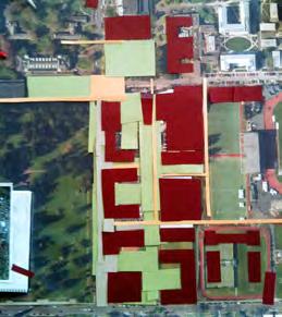
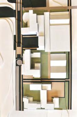
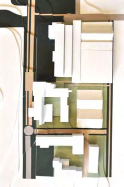
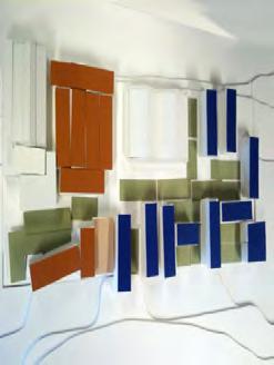
13 PROGRAM ANALYSIS BASELINE GENERATED FROM PREVIOUS STUDIES A composite plan shows how two independent, previous studies by YGH Architects and SERA Architects, respectively, would combine to redevelop the University Street Study Area (above, left). Because these studies were focused on building feasibility and programming, campus character and open space were not directly addressed. To fairly compare this composite baseline with the alternatives developed by this study, a physical model of the baseline schemes was developed (above, right). Dark green represents designated campus green space. Existing or proposed campus paths and promenades are represented in peach. Light green represents on-site open space within building sites. Rowell Brokaw Architects University Street Feasibility Study 11


 and the general university classrooms (which all")
14 PROGRAM ANALYSIS INTERIOR MALL CONCEPT SHOWN AS A DIAGRAM FOR DISCUSSION FROM INTERIOR MALL TO OPEN SPACE Early in this study, an idea was proposed by the concurrent Student Recreation Center design process to explore a strong interior connection among the programs a conditioned, mall-like corridor onto which departments would locate storefronts and mutually benefit from increased student traffic and visibility. Discussions with the program groups and study of the program needs found that while the concept of developing strong connective interior space was important, such connectivity was more tightly tied to campus identity than a particular set of interior spaces. The only identifiable areas of programmatic synergy were related to the Healthy Campus Initiative (as a mixing space for PE/Rec and Human Physiology) and the general university classrooms (which all programs could utilize). Other synergies related to interdisciplinary research and opportunistic collaboration. INTERMEDIATE SYNERGY DIAGRAM Based on these discussions and continued study of the site, it became clear that strong campus open space was the most critical synergy to develop, and that the consideration of specific campus patterns could support the desired outcomes. CAMPUS SPACE SYNERGY DIAGRAM 12 Rowell Brokaw Architects University Street Feasibility Study
15 PROGRAM ANALYSIS SYNERGIES & REQUIREMENTS CAMPUS SYNERGY In the initial stages of the University Street Study, a significant amount of discussion, investigation and analysis was devoted to uncovering potential synergies among the interested parties. It was hoped that these synergies would inform the building massing, adjacencies and design. Some interesting potential overlaps in programmed space came to light, particularly between PE/Rec, Human Physiology, and Product Design and by using the Healthy Campus Initiative as an essential link between all the departments. Required separations, acoustics, incompatible adjacent uses, and privacy were also noted as anti-synergies and important considerations with new development. The strongest synergy among the programs focused on the creation of active campus open space among optimally sited and scaled academic buildings. While big ideas like the Healthy Campus Initiative and interdisciplinary research were identified as authentic synergies, they are less influential to building form and site design. The quality of campus open space that knits these large programs together was found to be the most important opportunity. CAMPUS POLICY 5: REPLACEMENT OF DISPLACED USES Esslinger Replacement Total GSF of Esslinger - 97,000 Ground Level Footprint - 34,000 GSF Basement Footprint - 63,000 GSF Mac Court Re-Use or Replacement According to the 2010 McArthur Court Reuse Study, the adaptive reuse of McArthur Court for academic programs is possible, but not more efficient or less costly than new construction. Even with an additional story added to the existing structure, the existing building is projected to only hold one-third of the A&AA s net assignable program (75,000 SF). If Mac Court were to be replaced by a more efficient academic building in the same footprint, the new building could accommodate approximately 160,000 GSF. The proposed framework can accommodate the re-use of McArthur Court, but solar access and efficiency are both improved with a new building conforming to the basic massing and footprint identified. In addition, any scheme that includes the adaptive reuse of McArthur Court should account for approximately 60,000 SF of additional program in other buildings. Rowell Brokaw Architects University Street Feasibility Study 13


16 University Street: Looking South from near the EMU 14 University Street: Looking North from the top of University Hill
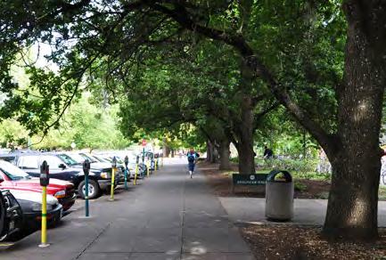
17 SITE CONTEXT PRELIMINARY SITE ANALYSIS EXISTING CONDITIONS The University Street Study Area includes a portion of the superblock bounded by 15th and 18th Avenues on the north and south, and Agate and University Streets on the east and west. Despite the fact that this area was University-owned land from the early years of campus development, it did not evolve in a similar manner to the rest of campus. In many cases, the university s designated open spaces have evolved in locations formerly occupied by city streets. Over the course of the last century, these streets have gradually transformed from vehicular throughways, to pedestrian and bike-dominated, tree-lined streets. The University Street block did not have this underlying structure and remained largely undeveloped because of its location in a low-lying area, likely a seasonal bog. Today, the University Street Axis functions as one of the widest city streets in Eugene. Its primary contribution to the campus is that of a parking lot, and one which is too wide to support a pedestrian-friendly environment. Existing buildings on the site include McArthur Court, Esslinger Hall, the Student Recreation Center (SRC), the Student Tennis Center (STC), the covered tennis courts and the Outdoor Program Barn. This study assumes that the Student Tennis Center will remain in its current form and location for the time being, and that Esslinger Hall and the Outdoor Program Barn will be replaced. In comparison with the academic core of campus, the University Street Study Area site lacks the designated open space, paths, mature landscape, and academic buildings that define the academic core. TOPOGRAPHY There is 30-foot difference in elevation from the highest point along University Street (474 ) to the lowest point of the Study Area east of the Student Tennis Center (444 ). The topography of this site presents a number of challenges and opportunities for building and site design, both at the street edge, and towards the middle of the block. The crest of the hill on University Street near the entrance to McArthur Court acts as a campus boundary. This landform, the street s parking-lot-like nature, and the absence of academic buildings all contribute to the feeling that areas south of Mac Court are not a part of campus. Rowell Brokaw Architects University Street Feasibility Study 15
18 SITE CONTEXT PIONEER CEMETERY To the west of University Street is the 15-acre Pioneer Cemetery (established in 1872), which is a City of Eugene landmark, and a National Historic Cemetery. The cemetery creates a unique condition on the campus and includes a formal landscape that includes direct connections to the School of Education and School of Music. Preliminary discussions with program groups identified both great opportunities for views over and through this borrowed landscape, as well as concerns about safety and the potential to create an attractive nuisance if conditions of the cemetery s use are not wellunderstood. The land on which the cemetery stands is not owned by the University and should not be disturbed. However, the relationship of the University Axis to this open space adjacent to campus can be greatly improved. MCARTHUR COURT Designed by Ellis Lawrence, the original construction of McArthur Court dates to McArthur Court was funded by the ASUO and named for Clifton N. Pat McArthur, the first president of the ASUO ( ) first editor of the student newspaper, and student director of athletics ( ), Speaker of the Oregon legislature and US Congress representative. It was originally designed to seat 6,000. Adaptive re-use studies of McArthur Court have found that the building s most efficient use is, not surprisingly, as an athletics arena, and that renovation for academic uses is technically feasible. The building includes 19,400 GSF in the basement, 38,885 GSF on the ground floor, 22,950 GSF in the first tier and mezzanine seating, 16,000 GSF in the first balcony, and 16,000 GSF in the second balcony to total 113,235 GSF. With regards to the A&AA program, only about 1/3 of the proposed building area could be accommodated within the structure. 16 Rowell Brokaw Architects University Street Feasibility Study


19 SITE CONTEXT Pioneer Cemetery: Looking West toward East Campus (left) and East toward Design Area F MacArthur Court: Under construction in Rowell Brokaw Architects University Street Feasibility Study 17
 and in its campus context (below), with designated")
 noted.")
20 SITE CONTEXT The existing conditions of Design Area F as described by the Campus Plan (top) and in its campus context (below), with designated campus paths (peach), campus edges (yellow), and designated open space (green) noted. 18 Rowell Brokaw Architects University Street Feasibility Study
21 SITE CONTEXT CAMPUS PLAN SUMMARY DESIGN AREA F In 2007, University leadership identified the opportunity to re-vision McArthur Court and surrounding areas for academic use. Until 2007, Design Area F was cataloged as a low-density precinct of campus, focused on Athletics and Recreation. The existing development densities of 25% maximum coverage area and 0.4 FAR are the lowest on campus. UNIVERSITY STREET The proposed framework transforms the University Street Axis into the University Axis. This proposal has precedent; the north end of the University Street Axis was once a through street. Nearby, the Emerald Axis is another example of a former city street that is now a non-vehicular, campus open space. The study proposes to develop the southern portion of University Street into a true gateway. It includes provisions for pedestrian use, green space, and bicycle and parking improvements. OPEN SPACE The University Street Axis and 15th Avenue Axis area the only designated open spaces in the Study Area or Design Area F. Both operate as wide streets, although relatively recent improvements and new construction have allowed 15th Avenue to manage this role more gracefully. The English oaks near the north end of the Study Area are the same variety as those planted in the Memorial Quad. Directly to the north of the Study Area, three designated open spaces inform the connection to the campus core. To the west, Pioneer Cemetery fronts the full length of the Study Area, which makes University Street unique in that it is a one-sided axis. CAMPUS EDGE 18th Avenue is a minor arterial adjacent to high-density residential. Along this highly visible edge of campus, the Campus Plan indicates that development should make every opportunity to improve visual qualities of area. The framework extends a grand and welcoming campus open space to the edge of campus, and by proposing new university-scale buildings and green space along this edge. PATHS Campus paths serving this area are located to the east of the SRC, along 15th Avenue, and along University Street s two existing sidewalks. An unpaved path through an alleé of fir trees crosses Pioneer Cemetery connects the School of Education to this area of campus at the joint between McArthur Court and Esslinger Hall. There is also a designated bike path along the north edge of the Pioneer Cemetery, adjacent to Gerlinger Green. The proposed framework increases path connectivity and the permeability of the block. An improved path system is proposed along the University Street Axis, including a designated bike path that would connect into the center of campus. Rowell Brokaw Architects University Street Feasibility Study 19

22 EXTENDING CAMPUS: OPEN SPACE FRAMEWORK OPEN SPACE FRAMEWORK The University of Oregon s campus heritage includes hierarchy of open spaces: quadrangles, axes, promenades, and greens. Campus quads are large rectilinear open spaces formed by three- or four-story buildings with monumental buildings at one or both ends. The width of quadrangles should be perceived as being flat. The Memorial and Pioneer Quads give definition to the academic core, and building sites on established quads are reserved for significant academic buildings. Axes and promenades are longer and narrower open spaces that connect and pass through greens and quads. Greens are significant open spaces that are larger than a courtyard but smaller than a quad. This existing open space framework is diagrammed below: QUADRANGLES QUADS + AXES + PROMENADES QUADS + AXES + PROMENADES + GREENS DESIGNATED OPEN SPACE Five new or improved designated open spaces are proposed by this framework: University Axis (now University Street Axis) Esslinger Green 17th Street Axis South Green Fields Axis The improvements to the University Street Axis allow for the fundamental character of campus to reach across the crest of University Hill. The development of Esslinger Green creates the opportunity for an accessible campus green space and activity node. The extension of the 17th Street Axis connects with the East Campus and informs future developments within Design Area F. The location of campus paths within these open spaces also inform opportunities to better connect this area of campus to academic uses to the north and west, across Pioneer Cemetery. The Campus Plan requires that new construction contribute to the designated Open Space Framework. The minimum required designated open space for project is 10% of GSF. Given the new construction studied by this report, this amounts to: 56,000 SF of designated open space for 350,000 GSF (16%) 10,500 SF of designated open space for 75,000 GSF (14%) 2,400 SF of designated open space for 20,000 GSF (12%) 20 Rowell Brokaw Architects University Street Feasibility Study


23 EXTENDING CAMPUS: OPEN SPACE FRAMEWORK 1 PROPOSED FRAMEWORK IN CAMPUS CONTEXT DESIGNATED OPEN SPACE 1 UNIVERSITY AXIS 2 ESSLINGER GREEN 3 17TH STREET AXIS 4 SOUTH GREEN 5 FIELDS AXIS Rowell Brokaw Architects University Street Feasibility Study 21

24 EXTENDING CAMPUS: TRANSPORTATION NETWORK Conceptual Site Section shown below Designated Campus Paths Vehicle Management Designated Bike Paths Conceptual Site Section 22 Rowell Brokaw Architects University Street Feasibility Study
25 EXTENDING CAMPUS: TRANSPORTATION NETWORK TRANSPORTATION The proposed transportation network prioritizes bike and pedestrian traffic while carefully managing limited vehicular and emergency access. Over time, the University Street Axis will transform from a city street into a grand axis of pathways and green space that reaches to the Heart of Campus. PATHS FOR PEDESTRIANS + BIKES A network of interconnected paths is one of the key elements missing from this precinct of campus. New campus paths will need to be designed to accommodate the high volume of students utilizing a 500-seat classroom, A&AA, Human Physiology, as well as the SRC and PE/Rec. The proposed minimum width for new designated pedestrian paths is 12 feet. In some areas, 20 paths would be more appropriate to the volume of student traffic projected. The framework also includes a two-way, designated bicycle path along the west side of University. This bicycle path would be separated from the path designated for pedestrian use along the west side of University Axis. TRAFFIC + PARKING The existing topography presents an excellent opportunity to implement structured parking on the site. New construction built along University Street would need to be brought to grade, and Howe Field currently sits a story below the street level. Access to structured parking could be gained from the 17th Avenue Axis or, more efficiently, at the intersection of 18th Avenue/Onyx Street. The framework allows for more than 400 structured parking spaces to support general University, EMU, A&AA and SRC uses, as well as approximately 25 on-street spaces. This quantity of parking far exceeds the current capacity of University Street while allowing the University Street Axis to function as designated green space. Efficient structured parking could be oriented north-south or east-west. The framework proposes a series of thresholds that manage cars at the edge of campus and improve the entry sequence along University. Automobile traffic would be allowed on the southern portion of the University Axis, but would then be redirected at a roundabout near the extension of the 17th Street Axis. This roundabout could also allow for a looped connection through the site along the 17th Street Axis if this area s use had high service access or delivery needs. Emergency and service access would be maintained using the paths located at the west side of the University Axis. Rowell Brokaw Architects University Street Feasibility Study 23
26 EXTENDING CAMPUS: TRANSPORTATION NETWORK BIKE PARKING The locations of bike parking in this area should reinforce existing bike routes, strengthen desire paths to the center of campus, and provide easy access to building entrances. A fall 2011 bicycle capacity study by Campus Planning found 2,500-2,700 bikes on campus. This same study concluded that demand is high and growing, and that covered bike parking is the most highly used (75-85% full). By contrast, caged bike parking is utilized at only 15-22%. The SRC and A&AA are two of the most heavily used areas of bike parking on campus, and their projected bike parking needs are much greater than the current number of dedicated spaces. Locating these two programs in close proximity to one another will dramatically increase the already high level of bike traffic in the Study Area. The space required to accommodate such high volumes of bike parking will seriously impact the quality, function and safety of campus open space unless it is carefully considered at an early stage. The most desirable locations for bike parking are currently along 15th and University, near the entry to the SRC and within the 10-minute walking circle from the campus core. With the development of a new A&AA complex along the University Axis and the creation of Esslinger Green, these desirable areas would likely shift slightly to the south. Additional bike parking along the east side of the SRC also presents an opportunity. Large, consolidated zones of bike parking are generally preferred and most heavily utilized. Bike parking should be located adjacent to bike paths, outside zones of high pedestrian use, and in eddy locations adjacent to buildings. New construction will also have the capacity to locate some secure parking within buildings or in areas adjacent to service entries. The study proposes to provide parking along both sides of the improved University Street Axis, with a large number of parking spaces adjacent to the dedicated bike path on the west side of the axis. (In the case of A&AA, projected bike parking need is projected to be % the current amount.) Human Physiology is not expected to have a significant impact on bike parking needs; however, some additional capacity should be factored in to accommodate this growing department. STREET SECTIONS Three conceptual street sections on the pages that follow describe how University Street could transition from a city streetscape to a campus open space. Minimum dimensions are noted, as well as recommended path dimensions and locations of significant bicycle parking. Near the intersection of 15th Avenue and University, building setbacks are also recommended to enhance the larger open space framework in this area. 24 Rowell Brokaw Architects University Street Feasibility Study
27 EXTENDING CAMPUS: TRANSPORTATION NETWORK 1 SECTION 1 EMERGENCY ACCESS Rowell Brokaw Architects University Street Feasibility Study 25

28 EXTENDING CAMPUS: TRANSPORTATION NETWORK 2 SECTION 2 EMERGENCY ACCESS 26 Rowell Brokaw Architects University Street Feasibility Study
29 EXTENDING CAMPUS: TRANSPORTATION NETWORK 3 SECTION 3 EMERGENCY ACCESS Rowell Brokaw Architects University Street Feasibility Study 27

30 28
31 EXTENDING CAMPUS: KEY PATTERNS KEY PATTERNS Construction projects will be developed in keeping with the Campus Plan. The following campus patterns were generative to the development of this framework and could be particularly important to the creation of a rich, cohesive whole in this precinct. OPEN SPACE FRAMEWORK The creation of new designated open space and the extension of the existing open space framework is the key to creating campus in this area. SUSTAINABLE DEVELOPMENT New development should ensure no net increase in campus energy use with new development, improved treatment of campus stormwater, and support of sustained campus habits. LOCAL TRANSPORT AREA Prioritize foot and bicycle traffic within the campus boundary while accommodating the convenient storage of vehicles. ACTIVITY NODES Create a linked series of activity nodes that vary in scale to generate pockets of public life. BUILDING COMPLEX Maintain human scale with the design of campus buildings and use bridges or arcades to link very large buildings (>100,000 GSF). FAMILY OF ENTRANCES Grouped, clearly identifiable entrances will support wayfinding and placemaking. POSITIVE OUTDOOR SPACE Place buildings to strengthen designated open space and generate positive on-site outdoor space. In the case of A&AA and the SRC programs, outdoor spaces are also needed to provide work courts and Outdoor Classrooms. ACCESSIBLE GREEN Incorporate a green of at least 50,000 SF and at least 100 in its narrowest dimension within 600 feet of every new building within the Study Area. PATHS & GOALS Identify points of interest and design paths to link these special places. QUALITY OF LIGHT Design buildings to create daylit interior spaces. Utilize natural light and solar access to create desirable spaces indoors and out. WHOLENESS OF PROJECT Maintain connections among the various projects planned for this area of campus, with the goal of creating a phased whole that is more beautiful than its individual parts. SOUTH FACING OUTDOORS Design buildings to allow solar access to designated open space and to maximum opportunities for sunny outdoor space. CAMPUS TREES Expand the campus arboretum with the preservation and planting of new trees (future heritage trees) in this area of campus. Rowell Brokaw Architects University Street Feasibility Study 29
 are of a much finer grain")
.")
, and a scenario in which McArthur")

32 EXTENDING CAMPUS: DENSITY COMPARISONS EXISTING CAMPUS GRAIN + PROPOSED SITE COVERAGE Buildings and development within the University s academic core (1) are of a much finer grain than the existing development within the University Street Study Area and Design Area F as a whole (2). Two variations on this proposal s redevelopment framework include a scenario in which McArthur Court is replaced with a more efficient academic building (3), and a scenario in which McArthur Court is reused for academic purposes (4). In this case, the vertical density of the surrounding development would need to increase by approximately 60,000 GSF to hold the additional program that McArthur Court cannot accommodate. 30 Rowell Brokaw Architects University Street Feasibility Study
33 EXTENDING CAMPUS: DENSITY COMPARISONS DENSITY COMPARISONS The existing FAR and coverage maximums for Design Area F are the lowest of any area of campus: 25% maximum coverage and a 0.40 floor-area ratio (FAR). The development density of Design Area F will need to increase to accommodate the programs included in this study. Collectively, the SRC, PE/Rec, general University classrooms, and A&AA account for nearly 750,000 GSF of indoor space, and both PE/ Rec and A&AA have additional Outdoor Classrooms. SITE COVERAGE Coverage area is one of the most direct expressions of campus character. The historic core of campus and the science quad are two of the coverage areas used as reference for this study. To accommodate the proposed programs, the percentage of maximum coverage for the Study Area would need to increase from 24% to 46%. The existing coverage maximum for Design Area F as a whole could remain at 25%. FLOOR-AREA RATIO (FAR) To accommodate the proposed programs and allow for future expansion without increasing coverage area, the FAR would need to be increased from 0.4 to 1.4 in the Study Area. The FAR for Design Area F would need to be increased from 0.4 to This would meet the needs of the proposed program and allow for 20% expansion in the future. (Additional area for expansion is accommodated primarily by increasing the floor-area ratio rather than increasing the coverage area.) PROPOSED DEVELOPMENT DENSITY Maximum Area Coverage (%) Maximum FAR (floor/area) Existing Campus 25-50% Design Area F (proposed) 25% Study Area (proposed) 40-46% FUTURE CONSIDERATIONS The large area of athletics fields, the re-use of McArthur Court, and the existence or replacement of the Student Tennis Center (STC) greatly influence the perceived density for Design Area F. Given the densities projected by this study, it seems unlikely that a building with as low a density as the Student Tennis Center would retain its location in the long term. With this in mind, a separate series of calculations was performed assuming that a three-story building with a comparable footprint to the STC could exist in the future (120,000 GSF). Similarly, the adaptive re-use of McArthur Court for academic purposes would likely require the allocation of an additional 60,000 GSF as additional stories in another location. Rowell Brokaw Architects University Street Feasibility Study 31
34 EXTENDING CAMPUS: DENSITY COMPARISONS SOLAR STUDIES A series of solar studies were completed to test the proposed framework and ensure that open space had adequate access to sun and light. These studies also generated a set of preliminary recommendations for building form. Academic buildings that are thin with footprints that create courtyard open space and daylighting opportunities were found to be most successful. Small courtyards bounded by buildings are likely to be shaded for most of the year. To ensure that a small courtyard is sunny, there should be either no buildings or low buildings on its south side. Solar studies demonstrate that courtyards should open to the south, if possible. If an open space has a tall building to the south, the massing of the building can be adjusted to support solar access for the open space. A variety of open space types and scales will provide a sense of diversity and discovery in this area of campus. Redevelopment plans should strive to generate a variety of open spaces that contain a diversity of sensory or climatic experiences and reinforce the overall open space framework. 32 Rowell Brokaw Architects University Street Feasibility Study


35 EXTENDING CAMPUS: DENSITY COMPARISONS 9:00 AM EQUINOX SHADOW PROJECTIONS 12:00 PM EQUINOX SHADOW PROJECTIONS 3:00 PM EQUINOX SHADOW PROJECTIONS SUNNY SPACE COMPOSITE A digital model was used to identify sunny spaces with high solar access (even in Oregon) based on shadow projections at 9:00am, 12:00pm and 3:00pm in September. Rowell Brokaw Architects University Street Feasibility Study 33


36 34
37 METHODOLOGY DESIGN PROCESS The process used to develop the University Street Study framework was diverse and layered, using a combination of physical models, computer modeling, collage, and hand media to translate input from program groups and study various aspects of the campus, block, building and landscape form. Following the project s introductory meetings, Rowell Brokaw Architects worked with diagrams and paper collage to study the grain of the campus core and the UO s existing planning framework. Subsequent volumetric studies were then introduced to access site capacity and track the specific space needs of the identified program groups. Patterns of open space were studied to access the permeability and scale of proposals in relationship to the campus core. Physical models were used extensively to test these proposals, account for space needs, study the significant topographic variation across the site, and verify the development of campus-scale buildings. Digital models were used to refine massing proposals and study solar access. Two preliminary alternatives were developed for discussion with the program groups, and these concepts were presented in diagram and physical models. Associated density calculations and program allocations were also discussed. With input from the program groups, a refined framework was then tested and vetted using solar studies and revised density calculations. Rowell Brokaw Architects University Street Feasibility Study 35
38 CONCLUSION CONCLUSION The findings from this study support the basic principles of campus planning: Designated open space and academic buildings working together give form and character to the extraordinary place that is the University campus. New, significant open space is needed in support of academic buildings and pathways to create the campus experience in this area. The transformation of the University Street Axis into a more significant campus open space the University Axis is an important step in extending campus to this site. It is an opportunity for a contemporary project to increase the significance and integrity of this historic landscape resource. Improvements to the University Street Study Area provide direct benefits to the programs that locate on site, but also to the campus as a whole. The development of the University Axis and the creation of new designated open space and paths will transform the University s southern gateway and improve the campus experience from 18th Avenue to the foot of Lawrence Hall. 36 Rowell Brokaw Architects University Street Feasibility Study


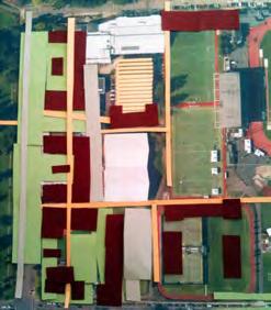
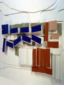
39 CONCLUSION The proposed framework (right) accommodates more program than the baseline scheme and also integrates meaningful campus open space and improvements to this campus gateway. These improvements allow the Study Area to both extend and strengthen the character of the academic core of campus. Rowell Brokaw Architects University Street Feasibility Study 37
40 Rowell Brokaw Architects 1 East Broadway Suite 300 Eugene, Oregon
University of Saskatchewan CAMPUS MASTER PLAN. Senate Meeting Preliminary Presentation. April 21, 2018 DIALOG ECS DA WATT
 University of Saskatchewan CAMPUS MASTER PLAN Senate Meeting Preliminary Presentation April 21, 2018 DIALOG ECS DA WATT project process presentation agenda Stakeholder Engagement Project Control phase1
Foreword to the Third + Edition
 U n i v e r s i t y of Oregon Campus Plan - Third + Edition, 2017 i Foreword to the Third + Edition Third + Edition (November 2017) This third + edition of the 2005 Campus Plan integrates amendments approved
CAL POLY MASTER PLAN UPDATE, March 2015
 Some Key Themes in the General Guiding Principles Academic Mission The plan must foremost advance the University s academic mission and student success. Foresight and Adaptability The plan should take
18 May 2016 CAMPUS MASTER PLAN UPATE
 18 May 2016 CAMPUS MASTER PLAN UPATE Council of the Deans ( Over view) AGENDA Engagement & What We Heard Focus Elements: 1. Development Framework Plan 2. Campus Mobility 3. Campus Guidelines 4. Wayfinding
This is the East Carolina University Comprehensive Facilities Master Plan Final Draft Plan Review. This workbook reviews the campus draft master plan
 This is the East Carolina University Comprehensive Facilities Master Plan Final Draft Plan Review. This workbook reviews the campus draft master plan first presented on campus on June 29 and June 30, 2011.
Moreno Valley College: Conceptual Master Planning - Site Analysis Lasselle Street, Moreno Valley, CA 92551
 Master Plan Architect School Name Moreno Valley College District Riverside Community College District Architecture and Urban Design 5898 Blackwelder Street Ground Floor Culver City, CA 90232 T: 310.559.5720
campus master plan VIRGINIA STATE UNIVERSITY
 campus master plan VIRGINIA STATE UNIVERSITY agenda 01 INTRODUCTION & GENERAL OVERVIEW 02 03 04 LAND USE CONCEPT PROGRAM ACCOMMODATION MAXIMIZE EXISTING INFRASTRUCTURE SUMMARY AND NEXT 05 STEPS agenda
City of Farmington. Downtown Plan. Amendment to the 1998 Master Plan Adopted October 11, 2004
 City of Farmington Amendment to the 1998 Master Plan Adopted October 11, 2004 Introduction Planning Background 1 Scope and Components of the Plan Amendment 2 Concept Introduction 3 Plan Concepts 3 Conceptual
Phase 1 : Understanding the Campus Context. Phase 2 : APPROACHES - Alternates & Preferred Plan
 Introduction MASTER PLAN PURPOSE WHY A CAMPUS MASTER PLAN? The purpose of the Master Plan at the University of Illinois at Chicago is to translate UIC s strategic goals and objectives into a compelling
FRUITVALE TRANSIT VILLAGE (Phase 2) Residential Project
 Residential Project") FRUITVALE TRANSIT VILLAGE (Phase 2) Residential Project DEVELOPER: SIGNATURE PROPERTIES ARCHITECT: HKIT ARCHITECTS April 23, 2010 TABLE OF CONTENTS 3 Vision 4 Description of Site 5 Guiding Concepts 6
FRUITVALE TRANSIT VILLAGE (Phase 2) Residential Project DEVELOPER: SIGNATURE PROPERTIES ARCHITECT: HKIT ARCHITECTS April 23, 2010 TABLE OF CONTENTS 3 Vision 4 Description of Site 5 Guiding Concepts 6
REPORT TO BOARD ON PREFERENCES tbp/architecture CCSF Facilities Master Plan, October 23, 2016
 PURPOSE The purpose of this report is to update the Board on the Facilities Master Plan initiative. PROCESS The Board conducted a Study Session about Phase 1 Needs on August 18, 2016. Since that time,
District Facilities Master Plan
 W o r k s h o p B o a r d District Facilities Master Plan February 29, 2012 BACKGROUND + CONTEXT ANALYSIS OPTIONS RECOMMENDATIONS NEXT STEPS DFMP AGENDA BACKGROUND + CONTEXT ANALYSIS OPTIONS RECOMMENDATIONS
ELMVALE ACRES SHOPPING CENTRE MASTER PLAN
 ELMVALE ACRES SHOPPING CENTRE MASTER PLAN Contents 1.0 INTRODUCTION... 2 2.0 LOCATION... 2 3.0 EXISTING CONTEXT... 2 4.0 VISION & GUIDING PRINCIPLES... 2 5.0 LAND USE AND BUILT FORM... 4 5.1 St. Laurent
WELCOME and introduction
 1 WELCOME and introduction Mobility Hub Locations within Burlington STUDY OVERVIEW STUDY OBJECTIVES The City of Burlington is developing four Area Specific Plans, one for each of Burlington s Mobility
New-Cast Mixed-use Development Proposal King Street West, Newcastle, Ontario
 URBAN DESIGN BRIEF New-Cast Mixed-use Development Proposal King Street West, Newcastle, Ontario TABLE OF CONTENTS: 1.0 Executive Summary 2.0 Creating Vibrant and Sustainable Urban Places: Excerpts from
Preci nct P l ans Figure 56 Campus Aerial Photo, 2008 CAL STATE EAST BAY, HAYWARD CAMPUS MASTER PLAN
 9 Precinct Plans This section contains a detailed discussion of the planning and design concepts for specific areas or precincts of the Cal State East Bay Hayward campus. The Precinct Plans pertain to
2015 Campus Master Plan Update
 September 15, 2015 2015 Campus Master Plan Update Campus and Community Analysis Summary Presentation A G E N D A 1. Scope & Schedule of the Master Plan 2. Planning Principles & Draft Goals 3. Background
PLAN ELEMENTS WORKSHOP. April 5, 2016
 PLAN ELEMENTS WORKSHOP April 5, 2016 needs more housing. But there is no one-size fits-all solution. Every neighborhood has its own character. In some places, density is not only appropriate it is badly
Urban Design Manual PLANNING AROUND RAPID TRANSIT STATIONS (PARTS) Introduction. Station Study Areas
 Introduction. Station Study Areas") 111111 PLANNING AROUND RAPID TRANSIT STATIONS (PARTS) Introduction The ION rapid transit system will link Waterloo, Kitchener and Cambridge through a central transit corridor (CTC). There are a number
111111 PLANNING AROUND RAPID TRANSIT STATIONS (PARTS) Introduction The ION rapid transit system will link Waterloo, Kitchener and Cambridge through a central transit corridor (CTC). There are a number
Clairtrell Area Context Plan
 Clairtrell Area Context Plan March 2005 Urban Development Services City Planning Contents 1. Introduction... 4 2. Development Structure... 6 2.1 Streets... 7 2.1.1 Sheppard Avenue and Bayview Avenue...
Gold Line Bus Rapid Transit Transit Oriented Development (BRTOD) Helmo Station Area Plan
 Helmo Station Area Plan") Appendix F Gold Line Bus Rapid Transit Transit Oriented Development (BRTOD) Helmo Station Area Plan Introduction and Purpose of the Plan The Gold Line Bus Rapid Transit facility is an eleven-mile dedicated
Appendix F Gold Line Bus Rapid Transit Transit Oriented Development (BRTOD) Helmo Station Area Plan Introduction and Purpose of the Plan The Gold Line Bus Rapid Transit facility is an eleven-mile dedicated
LANDSCAPE RESOURCE SURVEY
 LANDSCAPE RESOURCE SURVEY Campus Heritage Landscape Plan Eugene, Lane County, Oregon Spring 2007 n RESOURCE IDENTIFICATION & SUMMARY LANDSCAPE AREA NAME (o) Historic name(s) none known campus plan designation
CAMPUS MASTER PLAN UPDATE
 13 April 2016 CAMPUS MASTER PLAN UPDATE Focus Group Landscape AGENDA What We Heard Review of Campus Observations & Analysis Campus Framework & Open Space Network Table-Top Exercise Landscape Guideline
UNCW CAMPUS MASTER PLAN
 UNCW CAMPUS MASTER PLAN JULY 27, 2017 MASTER PLAN FRAMEWORK RECOMMENDATIONS BOARD OF TRUSTEES PRESENTATION UNCW Campus Master Plan Update Board of Trustees Presentation July 27, 2017 The attached Campus
implementation r expression in landscape
 6 ubc okanagan implementation campus plan r expression in landscape 68 6 implementation campus plan sections The Campus Plan supports the academic mission, values and commitments of the University by providing
Physical Structure. This historic image from 1882 emphasizes the dramatic topography that distinguishes Cornell s setting at the top of East Hill.
 Physical Structure The natural, agrarian and urban setting for Cornell s campus is a precious resource to protect and enhance. It has also shaped the physical structure of the campus. Buildings, roads
SUBJECT: Waterfront Hotel Planning Study Update TO: Planning and Development Committee FROM: Department of City Building. Recommendation: Purpose:
 Page 1 of Report PB-23-18 SUBJECT: Waterfront Hotel Planning Study Update TO: Planning and Development Committee FROM: Department of City Building Report Number: PB-23-18 Wards Affected: 2 File Numbers:
Vision & Land Use. Discussion. Historic Preservation Plan. Foggy Bottom Campus Plan:
 Vision & Land Use Foggy Bottom Campus Plan: 2006-2025 Historic Preservation Plan Discussion Community Meeting Presentation August 2, 2006 Presentation Format Overview Sherry Rutherford, GW Foggy Bottom
11 February CAMPUS MASTER PLAN UPDATE Focus Group - Design Guidelines
 11 February 2016 CAMPUS MASTER PLAN UPDATE Focus Group - Design Guidelines AGENDA Introductions Planning Scope The 2004 Campus Plan Observations Design Guidelines - 2004 Plan SWOT Exercise Analysis Goals
There are five comprehensive goals that inform the Urban Design element at FIU. They are:
 3.0 URBAN DESIGN ELEMENT This Comprehensive Master Plan Update reflects the University s commitment to the refinement and extension of the base concepts earlier master planning efforts have created. FIU
Official Plan Review: Draft Built Form Policies
 PG.30.1 REPORT FOR ACTION Official Plan Review: Draft Built Form Policies Date: May 15, 2018 To: Planning and Growth Management Committee From: Chief Planner and Executive Director, City Planning Division
Bus Rapid Transit Backgrounder. December 2016
 Bus Rapid Transit Backgrounder December 2016 Background The City of London is completing the second stage of Shift, its public transit planning exercise. Shift, focuses on rapid transit, along with vehicular
 Health Sciences City The available land area, although limited, combined with the unique partnership between the primary institutions and the supporting partnerships of the development interests within
1 Welcome! UBC Okanagan Master Plan Update - Open House
 1 Welcome! UBC Okanagan Master Plan Update - Open House UBC is updating the Master Plan for the Okanagan Campus. The purpose of today s Open House is to: Present the draft 2015 Master Plan Answer any questions
Update on University Avenue Study. September 21, 2015
 Update on University Avenue Study September 21, 2015 Existing Building Capacity Analysis Desired Potential Programs for Corridor District University Commons 50,000 +/- GSF Consolidate Student Services
U n i v e r s i t y o f S o u t h C a r o l i n a A i k e n. Land Plan Study
 U n i v e r s i t y o f S o u t h a r o l i n a A i k e n Land Plan Study 06.27.2008 Goals ampus Growth Develop a Land Plan that allows for the orderly expansion of the campus over the next ten years and
THE NEIGHBORHOOD TODAY
 THE NEIGHBORHOOD TODAY CORE AREA VISION How are we Good Urbanism A Site s DNA thinking about Elements of great Unique elements urban communities embedded in a place the site and design? ELEMENTS LIKE:
CHAPTER 6: Community Design and Appearance
 AGLE AREA COMMUNITY Plan CHAPTER 6 CHAPTER 6: Community Design and Appearance Community Design and Appearance How a community is designed and what a community looks like are attributes fundamental to the
Regency Developments. Urban Design Brief. Holyrood DC2 Rezoning
 Regency Developments Urban Design Brief Holyrood DC2 Rezoning Stantec Consulting Ltd. 7-31-2017 1. Overview Regency Developments intends to rezone the lands located at 8510 and 8511 93 Avenue, within the
LANDSCAPE RESOURCE SURVEY
 LANDSCAPE RESOURCE SURVEY Campus Heritage Landscape Plan Eugene, Lane County, Oregon Spring 2007 n RESOURCE IDENTIFICATION & SUMMARY LANDSCAPE AREA NAME (z) Historic name(s) 15th Avenue campus plan designation
The Master Plan Framework
 The Master Plan Framework The East Harbour Master Plan advances the development of 60 acres of former industrial lands east of the Don River. The Master Plan outlines a vision for a vibrant, transit-oriented
Academics Efficient use of space will be used to enhance investments in new pedagogies such as active learning classrooms.
 Goals and Assumptions Physical Planning Goals and Objectives The guiding principles of this Master Plan were developed in consultation with various constituencies that make up the NMSU community and were
BELLEVUE COLLEGE Campus Master Plan February 29, 2016 (Space Needs Updated on 04/13/2016) Bellevue College Campus Master Plan April 13, :08 PM
 Bellevue College Campus Master Plan April 13, :08 PM") BELLEVUE COLLEGE Campus Master Plan February 29, 2016 (Space Needs Updated on 04/13/2016) AGENDA / STEERING COMMITTEE MEETING 15:00 PLANNING PROCESS: 15:05 GUIDING PRINCIPLES: 15:10 SPACE NEEDS: 15:30
BELLEVUE COLLEGE Campus Master Plan February 29, 2016 (Space Needs Updated on 04/13/2016) AGENDA / STEERING COMMITTEE MEETING 15:00 PLANNING PROCESS: 15:05 GUIDING PRINCIPLES: 15:10 SPACE NEEDS: 15:30
GOODY CLANCY WITH KITTELSON & ASSOCIATES RHODESIDE & HARWELL FARR ASSOCIATES W-ZHA
 1 1. Welcome 5 min. 2. Follow-up from 9/22 / Corridor of Light, ground floor uses 20 min. 3. Small on-site open spaces / Overview of types, identities 15 min. 4. Rosslyn Plaza Park / Rosslyn Plaza PDSP
John M. Fleming Managing Director, Planning and City Planner. Old East Village Dundas Street Corridor Secondary Plan Draft Terms of Reference
 Report to Planning and Environment Committee To: From: Subject: Chair and Members Planning & Environment Committee John M. Fleming Managing Director, Planning and City Planner Old East Village Dundas Street
Phasing and Implementation
 Phasing and Implementation Adaptive Reuse and New Construction Opportunities The reuse of existing buildings at UW Tacoma S 21st St S 17th St Tacoma Ave is highly valued for maintaining the history, character,
Complete Neighbourhood Guidelines Review Tool
 Complete Neighbourhood Guidelines Review Tool Prepared By: City of Regina Planning Department October 2014 Page 1 of 14 Community Development Review Checklist for Secondary Plans and Concept Plans The
NEIGHBORHOOD 7: FEE LANE AREA. Aerial View of Briscoe and McNutt Dormitories
 NEIGHBORHOOD 7: FEE LANE AREA Aerial View of Briscoe and McNutt Dormitories Fee Lane Area Map Briscoe Dormitory 278 neighborhoods NEIGHBORHOOD 7: FEE LANE AREA EXISTING CHARACTER The Fee Lane Area neighborhood
Midtown Greenway Land Use and Development Plan Executive Summary
 Midtown Greenway Land Use and Development Plan Executive Summary Introduction The Midtown Greenway Land Use and Development Plan sets policy direction for land use and development in the Midtown Greenway
10 February CAMPUS MASTER PLAN UPDATE Focus Group - Landscape & Hensel Park
 10 February 2016 CAMPUS MASTER PLAN UPDATE Focus Group - Landscape & Hensel Park AGENDA Introductions Planning Scope The 2004 Campus Plan & Survey Observations 2004 Landscape Plan SWOT Exercise Analysis
FROST CAMPUS MASTER PLAN SIR SANDFORD FLEMING COLLEGE
 FROST CAMPUS MASTER PLAN SIR SANDFORD FLEMING COLLEGE SEPT 2015 TABLE OF CONTENTS 1.0 Introduction 01 1.1 Master Plan Purpose 1.2 About The Campus 2.0 The Campus Master Plan 05 2.1 Vision Statement 2.2
Courthouse Square Planning & Urban Design Study Working Group Meeting #11 September 2, 2014
 Courthouse Square Planning & Urban Design Study Working Group Meeting #11 September 2, 2014 1 Study Area Courthouse Square DRAFT Design Concepts A B C 3 Public Feedback July 23 Workshop & Online Survey
AvalonBay Communities + BRIDGE Housing. Mission Housing Habitat for Humanity Pacific Union Development Corporation
 AvalonBay Communities + BRIDGE Housing Mission Housing Habitat for Humanity Pacific Union Development Corporation Tonight s Agenda Recap of discussion from last CAC meeting Updates on meetings with Stakeholders
Lehigh Acres Land Development Regulations Community Planning Project
 Lehigh Acres Land Development Regulations Planning Effort Summary In July, 2010 Commissioner Frank Mann invited the Lehigh Acres community to start discussing how to achieve their recently adopted community
Gas Works Site Land-Use Study
 City of New Westminster Background Context 2 Neighbourhood Context 3 Program Elements 4 Proposed Site Planning Approach 5 Design Rationale 10 Design Elements 11 Phasing 21 C o n t e n t s b a c k g r o
EXISTING COMPREHENSIVE PLAN
 EXISTING COMPREHENSIVE PLAN Town Center Land Use Element: V. LAND USE POLICIES Town Center Mercer Island's business district vision as described in "Your Mercer Island Citizen-Designed Downtown" was an
Policies and Code Intent Sections Related to Town Center
 Policies and Code Intent Sections Related to Town Center The Town Center Vision is scattered throughout the Comprehensive Plan, development code and the 1994 Town Center Plan. What follows are sections
CAMPUS MASTER PLAN UPDATE Transportation Element Focus Group Meeting #3
 CAMPUS MASTER PLAN UPDATE 2010-2020 Transportation Element Focus Group Meeting #3 December 2012 5 03 December 2012 1 Campus Master Plan 2010-2020 : Transportation Agenda 1. MMC 2. EC a. Inventory & Analysis
Table of Contents. Elm Avenue Improvement Plan City of Waco, Texas. Introduction 1. Existing Context 1 Figure 1 2.
 Table of Contents Introduction 1 Existing Context 1 Figure 1 2 Plan Guidelines 3 Future Urban Form 4 The West-End 4 Main Street 6 The East-End 7 Figure 2 9 Public Improvement Recommendations 7 General
WEST LOOP DESIGN GUIDELINES CHECKLIST
 WEST LOOP DESIGN GUIDELINES CHECKLIST Section 1.0 General Strategies 1.1 DESIGN EXCELLENCE: ENCOURAGE HIGH QUALITY AND INNOVATIVE DESIGN OF NEW BUILDINGS WITHIN THE WEST LOOP WITHOUT BEING PRESCRIPTIVE
11 February CAMPUS MASTER PLAN UPDATE Focus Group - Research Park
 11 February 2016 CAMPUS MASTER PLAN UPDATE Focus Group - Research Park AGENDA Introductions Planning Scope The 2004 Campus Plan Observations SWOT Exercise Analysis Goals and Advice Questions & Discussion
38 Queen s University Campus Master Plan Part 1
 38 Queen s University Campus Master Plan Part 1 46 The Campus at the City Scale Chapter 4 The Campus at the City Scale 39 Queen s is an urban University centrally located in Kingston. Decisions made by
University of Denver Land Use Plan Update I. Executive Summary
 Executive Summary The task of developing a Land Use Plan for the University of Denver has been an exciting collaborative process that engaged a variety of interested people, including members of the University
242 neighborhoods NEIGHBORHOOD 4: JORDAN AVENUE CORRIDOR
 NEIGHBORHOOD 4: JORDAN AVENUE CORRIDOR Aerial View of Jordan Avenue Corridor EXISTING CHARACTER The Jordan Avenue Corridor is the portion of North Jordan Avenue that extends north from East Third Street
Bel-Air Lexus Automobile Service Station
 Bel-Air Lexus Automobile Service Station Design Brief 443-447 McArthur Avenue Ottawa April 30, 2015 14-1299-MCA Site Details Application: Site Plan Control Legal Description and Municipal Addresses: 443
Rio/29 Small Area Plan. Design Plan & Implementation Framework Open House - January 25, 2018
 Rio/29 Small Area Plan Design Plan & Implementation Framework Open House - January 25, 2018 MEETING PURPOSE PRESENTATION 1. Orient to the updated design plans 2. Introduce implementing options 3. Explain
TEMPLE MEDICAL & EDUCATION DISTRICT
 City of Temple, Texas TEMPLE MEDICAL & EDUCATION DISTRICT 1 Description. The City of Temple joined in partnership with key public and private entities to jointly promote education and medical activities
CAMPUS MASTER PLAN DRAFT PLAN UPDATE JANUARY
 NEW MEXICO HIGHLANDS UNIVERSITY CAMPUS MASTER PLAN DRAFT PLAN UPDATE JANUARY 27 2010 MASTER PLANNING GOALS TO BALANCE THE STRATEGIC GOALS OF THE UNIVERSITY WITH THE PHYSICAL CAMPUS through the assessment
599 Kennedy Road - Official Plan Amendment and Zoning Amendment Application - Preliminary Report
 STAFF REPORT ACTION REQUIRED 599 Kennedy Road - Official Plan Amendment and Zoning Amendment Application - Preliminary Report Date: March 7, 2017 To: From: Wards: Reference Number: Scarborough Community
University of the District of Columbia Van Ness Campus Master Plan Community Open House 3. December 8, 2010
 University of the District of Columbia Van Ness Campus Master Plan Open House 3 December 8, 2010 Introductions Sequence of Work: Campus Master Plan BEGIN: INTRODUCE AND START WORK Project Initiation Team
Subcampus Recommendations
 T he campus is is comprised of three major areas. These subcampus areas are known as WestCampus, South Campus, Campus Oakland and Drive East Campus. and Future East growth Campus. requires a Future careful
Office of Campus Planning. Subject: Campus Planning Committee Meeting, February 11, 2016
 Office of Campus Planning MEMORANDUM To: From: Campus Planning Committee Eleni Tsivitzi Campus Planning, Design & Construction (CPDC) Subject: Campus Planning Committee Meeting, February 11, 2016 The next
Workshop 3. City of Burlington Waterfront Hotel Planning Study. September 14, The Planning Partnership
 Workshop 3 City of Burlington Waterfront Hotel Planning Study September 14, 2017 The Planning Partnership The Waterfront Hotel Planning Study 01 The Brant & Lakeshore Planning Study will establish a Strategic
The transportation system in a community is an
 7 TRANSPORTATION The transportation system in a community is an important factor contributing to the quality of life of the residents. Without a sound transportation system to bring both goods and patrons
Part D. College Avenue Campus PAGE 121 UNIVERSITY OF REGINA / CAMPUS MASTER PLAN 2011
 Part D College Avenue Campus UNIVERSITY OF REGINA / CAMPUS MASTER PLAN 2011 PAGE 121 PAGE 122 PREPARED BY / DIALOG Figure D-1. A view of the College Building at the College Avenue Campus in winter 11.0
UTSC SECONDARY PLAN COMMUNITY OPEN HOUSE
 WELCOME TO THE UTSC SECONDARY PLAN COMMUNITY OPEN HOUSE 1 Welcome to the first Community Open House for the UTSC Secondary Plan. Hosted by the University of Toronto Scarborough (UTSC), the following panels
LANGAN LANDSCAPE ARCHITECTURE + PLANNING FOR COLLEGES & UNIVERSITIES
 LANGAN LANDSCAPE ARCHITECTURE + PLANNING FOR COLLEGES & UNIVERSITIES CONTACT Philadelphia Pennsylvania 1818 Market Street Suite 3300 Philadelphia PA 19103 215.845.8900 215.845.8901 ST. JOSEPH'S UNIVERSITY
THAT the attached Terms of Reference for the Thornhill Centre Street Study be approved.
 COMMITTEE OF THE WHOLE AUGUST 18, 2003 THORNHILL CENTRE STREET STUDY PLANNING FILE: 15.92 Recommendation The Commissioner of Planning recommends: THAT the attached Terms of Reference for the Thornhill
The Chinese University of Hong Kong Campus Master Plan Stage 3 Stakeholders' Engagement Report
 The Chinese University of Hong Kong Campus Master Plan Stage 3 Stakeholders' Engagement Report CONTENTS 1.0 OVERVIEW... 2 2.0 KEY FINDINGS... 3 2.1 Conserving Places of Value... 3 2.2 Places for Academic
FOCUS GROUP 4 Housing, Support Facilities & Student Life
 Meeting Minutes By: Perkins+Will - GK Date: 12/17/2012 Meeting Date: 12/4/2012 Project Name: BT-857 FIU-Campus Master Plan Update 2010-2020 Meeting Time: 8:00am-10:00am Project : 810369.000 Meeting Location:
Keystone Business Park Precinct Structure Plan North East Industrial Precinct. Part 2 Design Principles
 Keystone Business Park Precinct Structure Plan North East Industrial Precinct Part 2 Design Principles Context Issues Services Landform Issues Geotech and contamination Ecology Traffic and access Issues
Straub Hall Green (y)
") LANDSCAPE RESOURCE SURVEY Campus Heritage Landscape Plan Eugene, Lane County, Oregon Spring 2007 n RESOURCE IDENTIFICATION & SUMMARY LANDSCAPE AREA NAME (y) Historic name(s) none known campus plan designation
LANDSCAPE RESOURCE SURVEY Campus Heritage Landscape Plan Eugene, Lane County, Oregon Spring 2007 n RESOURCE IDENTIFICATION & SUMMARY LANDSCAPE AREA NAME (y) Historic name(s) none known campus plan designation
Record of the March 7, 2011 Campus Planning Committee Meeting
 April 5, 2011 MEMORANDUM To: From: Subject: Campus Planning Committee Christine Taylor Thompson, Planning Associate Campus Planning and Real Estate Record of the March 7, 2011 Campus Planning Committee
V. Vision and Guiding Principles
 V. Vision and Guiding Principles The Master Plan for the Powers Ferry Corridor seeks a foundation in the desires of the community. At times, various elements of the community offered opposing viewpoints,
Carleton University. Nicol Building New Sprott School of Business. Design Brief and Planning Rationale. Carleton University
 Carleton University Nicol Building New Sprott School of Business Design Brief and Planning Rationale Carleton University Design Team Proposal New Sprott School of Business Academic Building 2019 October
UNIVERSITY TOWN NEIGHBOURHOODS 5.5 HOUSING MELBOURNE CAMPUS MASTER PLAN 2014
 5.5 169 EXISTING CONDITIONS & VISION NEIGHBOURHOOD VISION The provision of on-campus housing into the future will continue to be an important element of the La Trobe University experience. A long-term
3.1 community vision. 3.3 required plan elements
 Chapter 3 Community Form 3.1 community vision 3.2 Parks & landscaping concepts 3.3 required plan elements D R A F T 20 Community Form Chapter 3 3.0 Community form 3.1 community vision The Specific Plan
CHAPTER FOUR: Alternatives to the Proposed Action
 CHAPTER FOUR: Alternatives to the Proposed Action CHAPTER FOUR: ALTERNATIVES TO THE PROPOSED ACTION 4.1 Alternatives to the West Campus Plan The following sections discuss alternatives to the proposed
Welcome. Walk Around. Talk to Us. Write Down Your Comments
 Welcome This is an information meeting introducing the applications for proposed redevelopment of the Yorkdale Shopping Centre site at 3401 Dufferin Street and 1 Yorkdale Road over the next 20+ years,
5.1 Site Plan Guidelines
 5. Community Core Guidelines Development of the Community Core will take place by plan of subdivision and site plan approval. It will occur in a phased manner that will reflect the timing of residential
THE GEORGE WASHINGTON UNIVERSITY MOUNT VERNON CAMPUS
 THE GEORGE WASHINGTON UNIVERSITY MOUNT VERNON CAMPUS CAMPUS PLAN AMENDMENT AND FURTHER PROCESSING APPLICATION: PRE-HEARING SUBMISSION PELHAM REPLACEMENT PROJECT FILED WITH THE ZONING COMMISSION OF THE
CAMPUS MASTER PLAN UPATE
 19 MAY 2016 CAMPUS MASTER PLAN UPATE Metropolitan Planning Organization AGENDA Introductions Planning Scope Observation & Analysis: Mobility Systems Campus Development Plan Mobility Planning Scenarios
Report to: Development Services Committee Report Date: April 24, 2017
 SUBJECT: Cornell Rouge National Urban Park Gateway - Report on Design Charrette and Next Steps PREPARED BY: Lilli Duoba, MES, MCIP, RPP, Manager, Natural Heritage (ext. 7925) REVIEWED BY: Marg Wouters,
PUBLIC REALM STRATEGY
 CONSULTATION DRAFT PUBLIC REALM STRATEGY Trenchard Street & Frogmore Street City Design Group Place Directorate Public Realm Strategy Trenchard Street & Frogmore Street Contents 1. Introduction 2. Understanding
University of Minnesota. MINNEAPOLIS CAMPUS DEVELOPMENT FRAMEWORK February 11, 2016
 MINNEAPOLIS CAMPUS DEVELOPMENT FRAMEWORK DEVELOPMENT FRAMEWORK of use shape the campus today and may inform the future. Form, meaning how the shape, size, orientation, and arrangement of buildings, spaces,
GUIDING PRINCIPLES IN THIS CHAPTER
 GUIDING PRINCIPLES The guiding principles and design concepts in this chapter work together with the Chapel Hill 2020 Comprehensive Plan to support new public places that can be enjoyed by all while also
Derry Green Corporate Business Park
 Town of Milton Derry Green Corporate Business Park Urban Design Guidelines BMI/Pace - June 2010 Draft 3 Prepared by: Brook McIlroy Planning + Urban Design / Pace Architects Suite 300-51 Camden Street Toronto,
North Downtown Specific Plan MEMORANDUM
 North Downtown Specific Plan MEMORANDUM MEETING DATE: November 13, 2017 TO: Members of the North Downtown Specific Plan Advisory Committee FROM: Jeanine Cavalli, Senior Planner SUBJECT: Materials for the
Town Center (part of the Comprehensive Plan)
") Town Center (part of the Comprehensive Plan) Mercer Island Town Center Looking North (2014) In 1994, a year-long process culminated in a set of design guidelines and code requirements for the Town Center
Town Center (part of the Comprehensive Plan) Mercer Island Town Center Looking North (2014) In 1994, a year-long process culminated in a set of design guidelines and code requirements for the Town Center
Courthouse Square Planning & Urban Design Study. Courthouse Square Working Group #13 October 15, 2014
 Courthouse Square Planning & Urban Design Study Courthouse Square Working Group #13 October 15, 2014 1 Courthouse Square Process Working Group Community Courthouse Square Advisory Groups & Civic Associations