TreeTOPS: A Regional Urban Forest Initiative May 17, 2010 This plan made possible by:
|
|
|
- Peter Wells
- 5 years ago
- Views:
Transcription

1 TreeTOPS: A Regional Urban Forest Initiative Regional Opportunities for Trees, Trails, and Open Space in Madera, Fresno, Kings, and Tulare Counties Central Valley, California May 17, 2010 This plan made possible by: California Department of Forestry and Fire Protection Urban Forestry Innovative Grant #8CA07818 and San Joaquin River Parkway and Conservation Trust
2 TreeTOPS: A Regional Urban Forest Initiative Regional Opportunities for Trees, Trails, and Open Space in Madera, Fresno, Kings, and Tulare Counties Central Valley, California TreeTOPS Leadership Team: Lee Ayres Regional Jobs Initiative Keith Bergthold City of Fresno Lynne Gorman Fresno County Mark Keppler Tree Fresno Dave Koehler San Joaquin River Parkway and Conservation Trust Barbara Steck Fresno County Council of Governments Kathy Wood United States Department of the Interior John Wright City of Clovis Prepared by AECOM San Francisco May 2010
3
4 Table of Contents Introduction... 1 TreeTOPS Vision Statement... 2 TreeTOPS Guiding Principles... 3 TreeTOPS Opportunities Development... 4 TreeTOPS Opportunities... 5 Tools for Implementation... 7 Land Use Mechanisms... 7 Funding Mechanisms... 8 TreeTOPS Phase II Work Plan TreeTOPS Summary Report Page i
5 TreeTOPS Summary Report Page ii This page intentionally left blank.
6 Introduction In November 2009, the first phase of planning for Madera, Fresno, Kings, and Tulare Counties began under the TreeTOPS grant from the California Department of Forestry and Fire Protection (CAL FIRE), administered through the San Joaquin River Parkway and Conservation Trust (Trust). This summary report provides a narrative and graphic overview of the planning work and results. The work took place from November 2009 through January 2010 with a stakeholder workshop on November 19, 2009, in Fresno, California, and a presentation of the TreeTOPS opportunities on January 29, 2010, in Kingsburg, California. This work is the first step in a longer term regional planning effort that will require additional data collection, a strong leadership and management team, and continued consensus building among the region s community members and many planning entities. Additional information compiled for this project, including the grant agreement, is on file at the Trust s office in Fresno. The primary purposes of the first phase of the grant are to: map key resources (four county scale) for a regional approach; prioritize zoning and conservation efforts to advance the TreeTOPS concept; identify priority areas of overlapping importance for next phase projects; develop a common greenprint language within the four county region; develop a geographically based opportunities map for trees, trails, and open space; and define data needs and next steps for future planning and implementation. The original proposal for TreeTOPS (Trees, Trails, and Open Space) was developed by Fresno community member Lee Ayres with assistance from Trust staff. The proposal called for a regional planning process that would look beyond the four counties political boundaries to envision how trees, trails, and open space could help define the region in the future. The goal is to ensure that future planning for the region incorporates these urban forestry elements to create a healthier and more economically and ecologically sustainable region. This is based on the premise that trees, trails, and open space areas provide important values and strong connections between people, land, and water in this portion of the Central Valley. The Visioning Session, held on November 19, 2009, featured Mayor Ashley Swearengin, co founder of the TreeTOPS initiative when she was leading the Regional Jobs Initiative, and Dr. Desiree Backman of the Sacramental Tree Foundation, who made a presentation on the health benefits of trees. In stakeholder discussion groups, the 55 participants expressed an interest in the following key themes: Regional and local trails Parklands as focal areas for recreation Healthy communities Conservation lands Habitat protection Future growth patterns Linkages and connectors Cultural focal areas Education and stewardship After the stakeholder workshop the initial geographic information system (GIS) mapping for the four county project area was created and embellished. It was then used to develop the key concepts and ideas that form the plan for TreeTOPS. A summary of the planning process and outcome was presented on January 29, 2010, as described below. TreeTOPS Summary Report Page 1
7 TreeTOPS Vision Statement Special places in the four counties are preserved and celebrated through the creation of a regional system of interconnected parks, trails, and linear forests, agricultural lands, and natural areas that provide healthy recreational, educational, cultural, and scenic experiences. TreeTOPS Summary Report Page 2
8 TreeTOPS Guiding Principles Purpose & benefits of TreeTOPS, a regional urban forest, trails, and open space preservation initiative Themes Special places are preserved, connected, and celebrated Compliment the Blueprint Plan and the Greenprint for the region Implemented incrementally through projects, programs, and General Plan updates Engage a wide spectrum of citizens A vision that illuminates many benefits: ecological, health, economic, and social Resource and recreation lands are woven together by trails and trees Productive landscapes are protected Travel ways are green Urban Forest Linear Forest to delineate corridors 1 and the boundaries of urban areas. Width, design, and vegetation appropriate to the location, mitigation challenge, and aesthetics. Tree canopy for bike lanes, sidewalks, parking lots, and trails Air quality law provide carbon sequestration and foster active transit to implement state legislation, AB32 and SB375 Health and Safety the calming effect and healing benefits of trees Shade for energy conservation, places to play and explore, and wildlife habitat Trails Regional trail system a signature amenity to connect our cities and environmentally significant resources 2 Active transit help achieve health and air quality objectives Walkable neighborhoods add value, recreation, convenience, and community building Economic impact attract and retain knowledge workers, reduce the cost of living, and geotourism: draw visitors to our rivers, conservation trust lands, national parks, and national forests with the San Joaquin River Trail, the Golden State Trail, and the Sierra to the Sea Trail Foster outdoor activity to improve fitness, mental health, cardio health, and child development. Open Space Preservation Foster outdoor activity; provide safe places to play Ground water recharge Air quality, habitat, and recreation benefits of vegetated landscapes Mental health, eye health, visual relief, and aesthetics Respect working farms and ranches Separate urban areas to contain sprawl and enhance community i 1 Freeways, irrigation canals, rivers, railroads 2 Sierra Mountain Range, Coastal Range, Pacific Ocean, national parks, national forests, lakes, and rivers TreeTOPS Summary Report Page 3
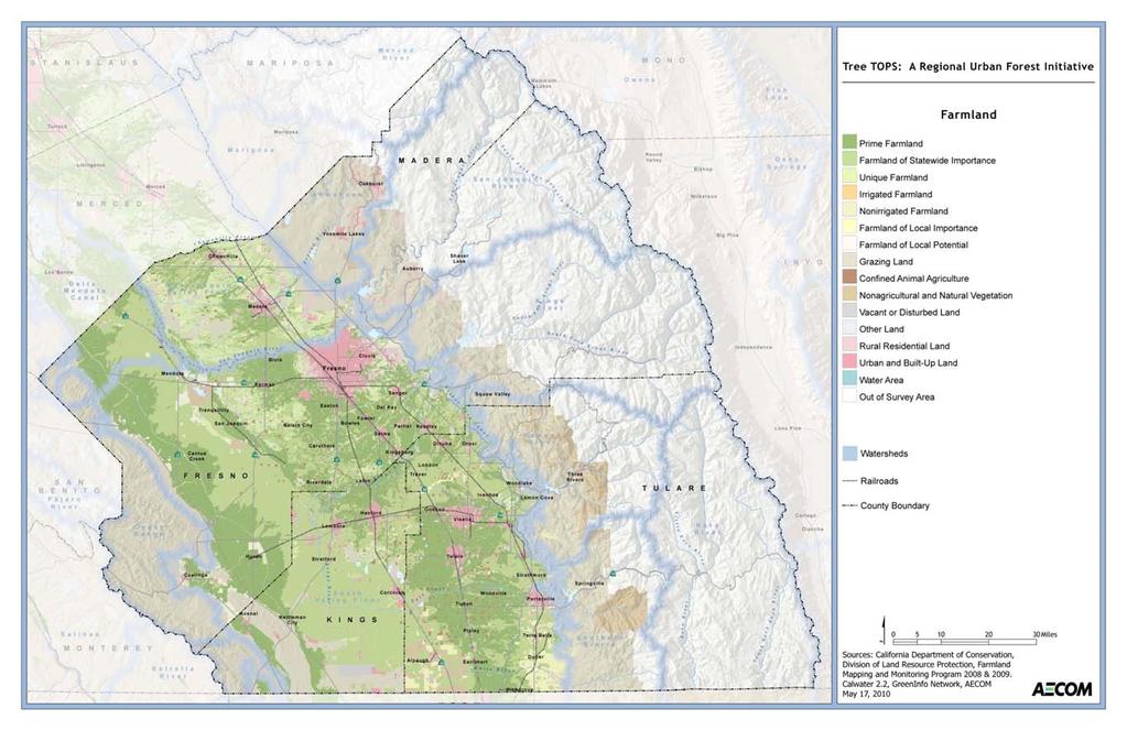
9 TreeTOPS Opportunities Development The TreeTOPS vision is unique in that the project area encompasses a larger, four county planning area that does not follow current political boundaries and seeks to provide a regional approach to developing the following geographic and resource based elements: Incorporate or create linear forests and greenways. Promote regional and local multiuse connections. Protect valuable farmland. Identify future conservation lands. Conserve quality habitats. Recognize critical water resources. The opportunities for TreeTOPS was developed using existing publicly available data that were compiled, edited, and managed to create GIS maps of the four county area for the project. The following data were collected and mapped: Four county aerial photos Existing city limits Watershed boundaries Existing railroads Publicly owned and protected land Data from the Farmland Mapping and Monitoring Program (FMMP) of the California Department of Conservation California Natural Diversity Database (CNDDB) data Existing trails and public land in the San Joaquin River Parkway To ascertain what future lands could become part of the TreeTOPS plan, lands that are currently in public ownership and protected as park, conservation, or wilderness form the base layer of GIS maps created for the project area. These areas are integral to developing future trail connections, conservation lands, farmland, and opportunities for vegetated greenways. A map of these lands within the project area is included as Attachment 1. A separate map was created to depict farmland in the region based on classification within the FMMP; this map is included as Attachment 2. The CNDDB map, Attachment 3, shows potential occurrences and ranges of plant and animal species documented through the California Department of Fish and Game. Subsets of the FMMP and CNDDB data were used to develop the TreeTOPS opportunities and are described in more detail below. Development of the GIS data for the project area is a first step in creating TreeTOPS opportunities; however, to improve and preserve data integrity, these data must be verified, maintained, and managed in the future. It is also assumed that additional GIS data will be added as more focused project areas are defined and a finer level of data is desired. TreeTOPS Summary Report Page 4
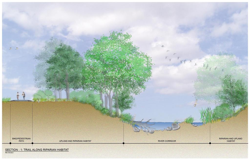
10 TreeTOPS Opportunities The TreeTOPS opportunities are shown in Attachment 4 and encompasses a subset of the base data layers described above, as well as criteria that further define the framework for future trees, trails, and open space features. The layer depicting public protected lands was overlaid with consolidated themes from the California Natural Diversity Database and Farmland Mapping and Monitoring Program. To illustrate the potential for future limitations on urban growth, a dashed line was placed around existing urban centers that represent an area for future growth, however limited. This urban boundary or buffer should be envisioned as a transition from urban to agriculture or strategic conservation lands. Implementation can take place using the criteria for vegetated corridors described below. Using the above noted layers as a combined base, the features were created to collectively provide future geographic and resource based locations as criteria to further implement a plan for TreeTOPS in the region. These are separate features, as described further below; together, however, they provide a reinforced and comprehensive framework for future implementation. Individually, these features serve as criteria for determining lands that would best serve as features or assemblages in implementing a plan for TreeTOPS. They can be used as criteria on their own or in concert with each other. Ideally, lands that contain all these features provide many of the values that are intended to be encompassed in a plan for trees, trails and open space. Watershed Buffers are shown as a subset of the watershed boundaries within the project area and define the valley floor. The concept for these buffers is to ensure high quality surface water and groundwater within the valley. The delineation of buffers will vary in size and location depending on the current land use and more detailed parcel characteristics. High quality habitat areas or lands that can contribute to clean surface water or groundwater quality should be a priority for these buffers. The buffers are generally shown in the higher elevations of the valley watershed, but they could be incorporated within and around the other plan features. These buffers can also be undeveloped or vegetated lands that are part of other land uses; however, regional planning efforts should consider the ability of buffers to help ensure high water quality and, if possible, increase water quantity (e.g., through rainwater harvesting or creative stormwater management). Habitat Blocks were conceived as areas where plant and animal habitats are of high quality and worthy of future protection. Species habitats are the main component of this feature; therefore, delineation of habitat blocks should consider the factors that contribute most to the protection of species, particularly those that are federally or state listed as rare, threatened, or endangered. Habitat blocks were developed by looking at the distribution of CNDDB data and defining larger blocks to demonstrate how these areas can be connected and form a larger cohesive and high quality habitat or mosaic of habitats. A character sketch of a potential habitat block is included as Attachment 5. Riparian Corridors are corridors that buffer the major rivers in the region and can also include other natural riparian areas throughout the four counties. These were conceived to recognize these water based landscape features as major defining elements in the region and to protect them as assets that can contribute to the TreeTOPS regional plan. The concept for these corridors closely follows what is already being done by the Trust, the Kings River Conservancy, and others. Because of the nature of the major rivers and their east/west alignments, these corridors can present major opportunities for trail and habitat connections between the Coast Ranges and the Sierra Nevada. The width and location of these corridors TreeTOPS Summary Report Page 5
11 will vary; however, regional planning efforts should consider protecting the river(s) or waterways and their associated habitats or defining landscape features that contribute to healthy riverine ecological function. Further parcel or assemblage analysis can also locate lands in riparian corridors with other resource values, such as contributing to the visual quality of the corridor. The ability to provide an important pedestrian or cycling connection that will allow for educational or interpretive opportunities and a high quality visitor experience should also be considered when mapping out these buffers. A character sketch of a riparian corridor is included in Attachment 6. Eco connectors are shown as arrows and are principally locations where there are opportunities to further link habitat blocks. The size and exact location of these will be further defined by those lands or assemblages that would provide wildlife corridors (e.g., linking smaller areas of high quality habitat to the larger blocks). These connectors could also include farmland, opportunities for adding vegetated corridors, and trails. The primary theme of the eco connectors is linking more natural areas to allow lands currently unencumbered by infrastructure and development to become the basis for this feature. Additionally, if development is in place or being planned in these areas, it would be advantageous to secure an open space corridor that could provide this type of link. Regional Connectors are generally linear features that coincide with infrastructure corridors such as railroads, canals, transmission lines, or the future Metro Rural Loop. These are envisioned as corridors that could have pedestrian trails and bikeways and could provide for vegetation or tree plantings for enhancement and a healthy urban forest network. These corridors can also be laid out and placed to link up with other plan features to provide stronger internal linkages or trail loops for recreation or commuter use. Regional connectors could also be located within developed areas to allow easy non motorized access from residential communities and commercial areas, thus reducing car trips. A character sketch of a regional connector is included as Attachment 7. When the opportunities are used with all of the above elements, there are areas in which many of the features coincide and overlap. This overlapping principally occurs in five major areas of the region: in and around the Mendota Wildlife Area, to the north and northeast of Fresno and east of Madera, in and around Lemoore and Hanford, south and west of Porterville, and north and east of Visalia. Further analysis is needed to verify the current mapping and ensure that it encompasses the values necessary for plan implementation and to further test and confirm the criteria for trees trails and open space. However, areas of overlapping features could be considered priority locations for further analysis, more detailed mapping suitability and implementation of specific projects demonstrating the TreeTOPS concept. TreeTOPS Summary Report Page 6
12 Tools for Implementation Below are examples of land use planning and funding mechanisms that can be incorporated into existing county and city zoning codes and general plans and considered for use in the protection of resource sensitive lands. These provide various options for obtaining land conservation and trail/public use easements or incorporating opportunities for urban forestry or vegetation programs into proposed development projects. Additionally, codes can be tailored with specific urban forestry and vegetation management programs. Please note that these are tools that have been successful in other places and may not be inclusive. Land Use Mechanisms Conservation Easements A conservation easement is a permanent restriction placed on a piece of property to protect its ecological, agricultural, or other open space values. A landowner voluntarily donates or sells certain development rights associated with the land, such as the right to subdivide. The conservation easement is a flexible instrument that can limit development as much as the landowner desires. The agreement is legally binding, and it applies even if the land changes hands. A third party, either a nonprofit organization or public agency enforces the easement to ensure that the landowner complies with its terms. Purchase of Development Rights Purchase of Development Rights (PDR) is similar to a conservation easement, except that a landowner willingly relinquishes all rights to develop land as real estate. A third party, typically a local agency or land trust, compensates a landowner for the value of the development rights, which usually varies from 30% to 80% of the property s fair market value. The landowner maintains ownership of the land, and other uses such as agriculture or forestry may continue. The agreement results in a permanent deed restriction that applies even if the property changes hands. Transfer of Development Rights A Transfer of Development Rights (TDR) program is similar to PDR in that the landowner receives compensation for the development value of the land. However, instead of acquisition of the land, the TDR system relies on the free market to redistribute development rights from open land to development areas. In some TDR programs, rights transfer directly between properties: a landowner sells development rights to preserve open space, and a developer buys these rights in order to develop at greater densities than currently permitted in a particular area. In other TDR programs, a municipality purchases development rights and maintains them in a development rights bank until a buyer is located. Cluster Development Cluster development concentrates new residential development on a portion of a land parcel, thereby retaining the remaining land for open space preservation. A zoning ordinance or other local regulation specifies minimum standards for open space protection and residential density. Cluster development allows the same number of units as under regular zoning; however, increased residential densities or reduced minimum lot sizes or setbacks limit development to a portion of the parcel. TreeTOPS Summary Report Page 7
13 Urban Growth Boundaries An urban growth boundary or urban limit line is an officially adopted and mapped line that defines where growth should and should not occur. Urban growth boundaries contain or control development within a specific area while protecting ecological, agricultural, or other open space values of the lands outside the boundary. A government body at the city, county, or regional level adopts an urban growth boundary for a finite period as a long term strategy to manage growth. Funding Mechanisms Mitigation Banking A mitigation bank is a wetland, stream, or other resource area that has been restored, established, enhanced, or (in certain circumstances) preserved for the purpose of providing compensation for unavoidable impacts to aquatic or other resources. A mitigation bank may be created when a government agency, corporation, nonprofit organization, or other entity undertakes these activities under a formal agreement with a regulatory agency (US EPA website Mitigation banking can be used as a tool to preserve or protect resource sensitive land however is generally used this way with an agreement with a regulatory agency with permitting authority. Bond Financing Bond financing is a type of long term borrowing that state and local governments frequently use to raise money, primarily for long lived infrastructure assets. They obtain this money by selling bonds to investors. In exchange, they promise to repay this money, with interest, according to specified schedules. The interest the state has to pay investors on the bonds it issues for public infrastructure is exempt from their federal and state income taxes, which makes the state s interest cost on the bonds less than it otherwise would be (California Legislative Analyst Office website There have been many bond sales in California that result in funding for the acquisition of open space or other land protection for the purposes of protecting natural and cultural resources that benefit the public. Foundation and Government Grants Grants are financial mechanisms that generally originate from an organization or government entity to provide money for particular activities that further the mission of the donor. Typically, grants require an application that defines the purpose and use of the money and also requires that there be matching funds or in kind services provided by the applicant. This project was funded by such a grant. Grants can be provided for a wide range of services and activities and include projects that would implement the TreeTOPS mission. Corporate/Philanthropic Donations Corporate or philanthropic donations are monies that are provided by corporations, foundations or not for profit entities for the purpose of providing services, objects or financing for public projects. These are used for a variety of purposes but are often utilized for the protection of open space, trail easements or other related projects that further the TreeTOPS purpose. Typically, donations further the mission of the donating organization. TreeTOPS Summary Report Page 8
14 Sale of Naming Rights The right to name a piece of property, either tangible property or an event, usually granted in exchange for financial consideration. Institutions like schools, Institutions like schools, places of worship and hospitals have a tradition of granting donors the right to name facilities in exchange for contributions. Securing the naming rights for stadiums, theaters, and other public gathering places is seen by companies as a form of advertising, and naming rights deals worth millions of dollars have been made (Wikipedia). TreeTOPS Summary Report Page 9
15 TreeTOPS Phase II Work Plan Prop 84 SGC Planning Grant The compelling benefits of a TreeTOPS i Urban Greening plan for the region are as follows: ii Trees improve air quality, the walking and bicycling experience, physical health, mental health, ground water recharge, community appearance and property values. Trees reduce the cost of living, crime, and energy use. Trails promote walking, bicycling, geo tourism iii, Trails reduce obesity, the cost of living, and the number of auto trips. Open space preservation enables us to have more outdoor activity, ground water recharge, safe places to play, working farms and ranches, habitat protection, and greenbelts that contain sprawl and mitigate land use conflicts. Open space preservation improves air quality, eye health, visual relief and aesthetics. The work plan for TreeTOPS (Phase 2) Urban Greening Plan is based on page 7, UG Planning Guidelines: Needs Assessment: See Phase 1 below, supplemented as required Development of the Plan s Goals, Objectives, and Action Steps to address: o The urban forest on the boundaries of the river corridors, freeway corridors, rail corridors and cities; iv and prepare prototype planting plans appropriate to the setting (see Plant Palette below) o A definitive Tree Canopy plan for each city with an inventory and implementation plan o Definitive plans for trails of regional significance and an implementation plan o Definitive plans to preserve strategic open space and an implementation plan o Prototype Urban Greening General Plan amendments for each county and city with supporting documentation and plans. Public Outreach and Stakeholders Meetings: Form and staff a TreeTOPS Urban Greening network of residents, planning professionals and strategic partners Coordination: Compliment the COG and Caltrans Blueprint plans Developing first draft of the Plan and Plant Palette Public Review of the Draft Plan State Review of the Draft Plan Completion of the Plan Phase 1, funded by a Prop 84 Cal Fire grant, provides the following material to support Phase 2: Vision statement; Guiding Principles Compiled and edited data to prepare GIS maps for the four county area TreeTOPS Opportunities Powerpoint Presentation Shorthand for Trees, Trails, and Open Space preservation 1 Madera, Fresno, Kings, and Tulare and adjacent counties as required 1 Sierra mountain range, Coastal Range, Pacific Ocean, three national parks, two national forests, lakes and rivers 1 Communities with 5,000 or more people TreeTOPS Summary Report Page 10
16 ATTACHMENT 1 Public Protected Lands Map
17
18 ATTACHMENT 2 State Farmland Mapping and Monitoring Program Map
19
20 ATTACHMENT 3 California Natural Diversity Database Map
21
22 ATTACHMENT 4 TreeTOPS Opportunities

23
24 ATTACHMENT 5 Opportunities for Regional Trails

25
26 ATTACHMENT 6 Habitat Block Character Sketch

27
28 ATTACHMENT 7 Riparian Corridor Character Sketch
29
30 ATTACHMENT 8 Regional Connector Character Sketch

31
32 i Shorthand for Trees, Trails, and Open Space preservation ii Madera, Fresno, Kings, and Tulare and adjacent counties as required iii Sierra mountain range, Coastal Range, Pacific Ocean, three national parks, two national forests, lakes and rivers iv Communities with 5,000 or more people
This page intentionally blank.
 This page intentionally blank. Parks, Recreation, and Open Space Chapter Relationship to Vision Vision Parks, Recreation and Open Space Chapter Concepts County Government. County government that is accountable
Regional Context Statement
 Regional Context Statement REGIONAL CONTEXT STATEMENT 3. REGIONAL CONTEXT STATEMENT In 1995, the Provincial Government passed into law the Growth Strategies Act. The purpose of this provincial initiative
OPEN SPACE CHAPTER 7: OVERVIEW. Preserve open space to protect natural resources, enhance character and provide passive recreation opportunities
 CHAPTER 7: OPEN SPACE OVERVIEW Ridgefield has made tremendous progress permanently preserving areas of town as open space. Open space preservation can serve many important purposes, including: protect
RECREATION, OPEN SPACE AND GREENWAYS ELEMENT GOALS, OBJECTIVES, AND POLICIES
 RECREATION, OPEN SPACE AND GREENWAYS ELEMENT GOALS, OBJECTIVES, AND POLICIES GOAL R-1: DEVELOP A RECREATION, OPEN SPACE AND GREENWAYS SYSTEM AS AN INTEGRAL COMPONENT OF AN OVERALL, COUNTY-WIDE ECONOMIC
National Association of Conservation Districts. Kris Hoellen Vice President, Sustainable Programs The Conservation Fund September 19, 2013
 National Association of Conservation Districts Kris Hoellen Vice President, Sustainable Programs The Conservation Fund September 19, 2013 Our Mission The Conservation Fund forges partnerships to conserve
Support the implementation of Cape Coral's Comprehensive Plan. Protect and utilize the unique natural resources in the City.
 7.0 OVERVIEW - RECOMMENDATIONS Chapter 7 The preparation of the Cape Coral Parks and Recreation Master Plan spanned a period of approximately 12 months. Plan preparation included the input of a wide range
3. VISION AND GOALS. Vision Statement. Goals, Objectives and Policies
 Vision Statement Queen Creek s interconnected network of parks, trails, open spaces and recreation opportunities provide safe and diverse activities and programs that sustain its unique, small town, equestrian
S A C R A M E N T O C O U N T Y JACKSON HIGHWAY & GRANT LINE EAST VISIONING STUDY
 JACKSON HIGHWAY & GRANT LINE EAST S A C R A M E N T O C O U N T Y P L A N N I N G D E P A R T M E N T SUMMARY AND WORKBOOK November 19, 2008 History of the Visioning Study Sacramento County has two growth
Green Infrastructure Policies and Ordinances
 Green Infrastructure Policies and Ordinances October 23, 2013 By Karen Firehock, Green Infrastructure Center 2013 Georgia Urban Forest Council s 23 rd Annual Conference The mission of the nonprofit Green
Conservation Corridor Planning and Green Infrastructure Themes
 Conservation Corridor Planning and Green Infrastructure Themes Prepared by the Green Infrastructure Center Inc. and the Northern Virginia Regional Commission February 22, 2011 Brief Overview Project Background
STEWARDSHIP OF LONG ISLAND SOUND S ECOLOGICAL AND RECREATIONAL RESOURCES
 STEWARDSHIP OF LONG ISLAND SOUND S ECOLOGICAL AND RECREATIONAL RESOURCES Robin Kriesberg, Save the Sound, Inc. Thomas Halavik, US Fish and Wildlife Service Coastal Program An Initiative to Identify, Protect
I. STAFF POLICY RECOMMENDATIONS. The following RMP policy strategies are proposed by staff in support of a Scenic Resource Protection Program:
 Policy Consideration: Scenic Resource Protection Program Status: For Consideration by the Highlands Council at September 14, 2006 Work session Date: September 12, 2006 I. STAFF POLICY RECOMMENDATIONS The
RECREATION AND OPEN SPACE ELEMENT GOALS, OBJECTIVES, AND POLICIES
 RECREATION AND OPEN SPACE ELEMENT GOALS, OBJECTIVES, AND POLICIES Goal 7 To provide park facilities, recreation programs, and open space resources that are safe, adequate, and accessible to all City residents,
Parks, Open Space and Trails
 Introduction Parks have often been referred as the lungs of our cities, cleansing the air of pollutants and particulate matter. Parks are also gathering places for families and community. They offer spaces
10.0 Open Space and Public Realm
 10.0 Open Space and Public Realm 10.0 Open Space and Public Realm The Public Open Space System is comprised of: outdoor spaces available for public use that are either publicly owned (e.g., parks and
City of Missoula and Missoula County Open Space Planning Open House
 City of Missoula and Missoula County Open Space Planning Open House FEBRUARY 6, 2018 The following slides contain the display board content from the open house. Please use boards to answer questions in
Preface. Erie. Scranton. Allentown. Pittsburgh. Harrisburg. Philadelphia
 The Southern Alleghenies Region The Southern Alleghenies Region spans the Laurel Highlands and Allegheny Front in the west across the Appalachians to the east. It is comprised of Blair, Bedford, Cambria,
{Best Practices. Summary of Tools, Strategies and Best Practices from 11 Michigan Case Study Communities
 Case Studies Michigan Coastal Community Working Waterfronts { Summary of Tools, Strategies and from 11 Michigan Case Study Communities Table of Contents Zoning...2 Community and Stakeholder Collaboration
TOWN OF BETHLEHEM OPEN SPACE CONSERVATION PLAN PUBLIC MEETING: OCTOBER 12, 2017
 TOWN OF BETHLEHEM OPEN SPACE CONSERVATION PLAN PUBLIC MEETING: OCTOBER 12, 2017 Welcome and Agenda 6:00 6:45: Open House, Part One 6:45 7:15: Presentation and Questions 7:15 8:00: Open House, Part Two
Minnesota Department of Natural Resource - Natural Resource Guidance Checklist Conserving Natural Resources through Density Bonuses
 Minnesota Department of Natural Resource - Natural Resource Guidance Checklist Conserving Natural Resources through Density Bonuses NRDB Why Use Density Bonuses & This Checklist Local units of government
DRAFT Amsterdam/Churchill Community Plan (4/17/08) Adopted By the Gallatin County Commission
 Adopted By the Gallatin County Commission") DRAFT Amsterdam/Churchill Community Plan (4/17/08) Adopted By the Gallatin County Commission Table of Contents Acknowledgements Chapter 1: Introduction A Brief History What s Next Authority Organization
DRAFT Amsterdam/Churchill Community Plan (4/17/08) Adopted By the Gallatin County Commission Table of Contents Acknowledgements Chapter 1: Introduction A Brief History What s Next Authority Organization
Arlington, Virginia is a worldclass
 EXECUTIVE S U M M A RY Arlington maintains a rich variety of stable neighborhoods, quality schools and enlightened land use policies, and received the Environmental Protection Agency s highest award for
A BLUEPRINT FOR BROCKTON A CITY-WIDE COMPREHENSIVE PLAN
 A BLUEPRINT FOR BROCKTON A CITY-WIDE COMPREHENSIVE PLAN Public Meeting October 2016 1 Plan Summary and Discussion Public Meeting May 4 2017 City of Brockton Bill Carpenter, Mayor Department of Planning
Central Lake Ontario Conservation Conservation Lands Master Plan
 Conservation Lands Master Plan Top 13 Frequently Asked Questions 1. What are conservation lands? Where are these conservation lands located in the Central Lake Ontario Conservation watershed? Conservation
DRAFT FOR PUBLIC REVIEW. Game Plan for a Healthy City
 DRAFT FOR PUBLIC REVIEW 2018 Game Plan for a Healthy City 2 Denveright. Parks & Recreation Game Plan Draft for Public Review Draft for Public Review Executive Summary Game Plan Overview Executive Summary
Chapter 13: Implementation Plan
 Implementation A. Introduction The Implementation Plan, in table form on the following pages, provides a summary of all the Action Items recommended in Chapters 2 through 12. The table also indicates which
The Five Components of the McLoughlin Area Plan
 The Five Components of the McLoughlin Area Plan This documents contains the complete language of the five components of the McLoughlin Area Plan: The Vision Statement The Values The Guiding Principles
Member Service Plan Sierra Nevada AmeriCorps Partnership
 Member Service Plan Sierra Nevada AmeriCorps Partnership Service plans lay the framework for what each Member will be doing during their service. Service plans detail the major projects and expected results
Conservation Corridor Base and Thematic Maps
 Conservation Corridor Base and Thematic Maps August 20, 2010 This project is funded in part by the Virginia Coastal Zone Management Program at the Department of Environmental Quality through Grant #NAO9NOS4190163
SUBJECT: Waterfront Hotel Planning Study Update TO: Planning and Development Committee FROM: Department of City Building. Recommendation: Purpose:
 Page 1 of Report PB-23-18 SUBJECT: Waterfront Hotel Planning Study Update TO: Planning and Development Committee FROM: Department of City Building Report Number: PB-23-18 Wards Affected: 2 File Numbers:
Blue/Green Infrastructure Study Accomack County, VA
 Blue/Green Infrastructure Study Accomack County, VA Draft Asset Maps March 8-9, 2010 Green Infrastructure Center, Inc. 2 Overview What is Green and Blue Infrastructure Project Timeline & Tasks Literature
Potential Green Infrastructure Strategies May 6, 2015 Workshop
 Potential Green Infrastructure Strategies May 6, 2015 Workshop Background The City of Cortland is developing the Tioughnioga Urban Headwaters Green Infrastructure Action Plan with funding from the National
IMPLEMENTING SOMERSET COUNTY S INVESTMENT FRAMEWORK
 IMPLEMENTING SOMERSET COUNTY S INVESTMENT FRAMEWORK SMART CONSERVATION THROUGH SMART GROWTH NJ LAND CONSERVATION RALLY March 22, 2014 Laurette Kratina, PP, AICP, Supervising Planner Somerset County Planning
Community Conservation Workshop. Saranac River Basin Communities
 Community Conservation Workshop Saranac River Basin Communities 2 Community Conservation Program Welcome! We have designed a Community Conservation Program that listens to the needs of community members.
CHAPTER 4 FUTURE LAND USE AND URBAN SERVICES DISTRICTS
 CHAPTER 4 FUTURE LAND USE AND URBAN SERVICES DISTRICTS Introduction This chapter discusses how Benzie County should grow and change in the future. A community can grow and change in many different ways.
Town of Peru Comprehensive Plan Executive Summary
 Town of Peru Comprehensive Plan Executive Communities that plan grow by choice, not by chance. A plan makes growth thoughtful, understandable, and predictable. A plan shows that a community is managing
Office of Greenways & Trails Providing Statewide Leadership and Coordination. Southeast Greenways and Trails Summit October 1-3, 2017
 Office of Greenways & Trails Providing Statewide Leadership and Coordination Southeast Greenways and Trails Summit October 1-3, 2017 1 Office of Greenways and Trails The Office of Greenways and Trails
Community Conservation Workshop. Lake Placid
 Community Conservation Workshop Lake Placid 2 Community Conservation Program Welcome! We have designed a Community Conservation Program that listens to the needs of community members. We are conducting
COASTAL CONSERVANCY. Staff Recommendation March 25, 2004 LOS ANGELES GREEN VISION PLAN. File No.: Project Manager: Marc Beyeler
 COASTAL CONSERVANCY Staff Recommendation March 25, 2004 File No.: 04-014 Project Manager: Marc Beyeler RECOMMENDED ACTION: Authorization to disburse up to $50,000 to the University of Southern California
North Fair Oaks Community Plan Summary and Information
 North Fair Oaks Community Plan Summary and Information WHAT IS THE NORTH FAIR OAKS COMMUNITY PLAN? The North Fair Oaks Community Plan is part of the San Mateo County General Plan, and establishes policies
Executive Summary Purpose of the Plan Defining Open Space and Greenways
 Executive Summary Bucks County possesses a vast array of open space resources including natural areas, parks, farmland and historic and cultural resources that contribute to a high quality of life valued
Improve Neighborhood Design and Reduce Non Point Source Water Pollution
 HOW TO Planning Guide Improve Neighborhood Design and Reduce Non Point Source Water Pollution This document was funded by a grant from the New Hampshire Coastal Program with funding from the National Oceanic
DISCUSSION TOPIC: ST JOHNS RIVER & ITS TRIBUTARIES (BPII) 2030 COMPREHENSIVE PLAN POLICES AND REGULATORY FRAMEWORK
 2030 COMPREHENSIVE PLAN POLICES AND REGULATORY FRAMEWORK") DISCUSSION TOPIC: ST JOHNS RIVER & ITS TRIBUTARIES (BPII) 2030 COMPREHENSIVE PLAN POLICES AND REGULATORY FRAMEWORK St. John s River & Its Tributaries Issue Summary: The St. Johns River is an important
DISCUSSION TOPIC: ST JOHNS RIVER & ITS TRIBUTARIES (BPII) 2030 COMPREHENSIVE PLAN POLICES AND REGULATORY FRAMEWORK St. John s River & Its Tributaries Issue Summary: The St. Johns River is an important
1 Introduction. Chapter. In this chapter:
 Chapter 1 Introduction In this chapter: 1.1 A Snapshot of the Region 1.2 Towards a Sustainable Region 1.3 The Provincial Context 1.4 Purpose and Organization The Regional Municipality of York Official
Objectives and Strategies for the Integration of Recreation, Parks and Open Space in Regional Plans
 BULLETIN 2 Objectives and Strategies for the Integration of Recreation, Parks and Open Space in Regional Plans TABLE OF CONTENTS Introduction 3 Land-use Framework Outcomes 1 4-8 Land-use Framework Outcomes
Whitemarsh Township Greenway Plan
 Whitemarsh Township Greenway Plan Prepared for: Whitemarsh Township August 16, 2007 Table of Contents Table of Contents... i Introduction... 1 Study Area Setting... 2 Regional Setting... 2 Township Character...
Whitemarsh Comprehensive Plan Update: Housing & Land Use. Public Workshop #3: September 20, 2018
 Whitemarsh Comprehensive Plan Update: Housing & Land Use Public Workshop #3: September 20, 2018 Agenda Welcome Process Recap What We ve Heard The Plan Framework Review of Recommended Actions Land Use Housing
Florida Greenways and Trails System (FGTS) Plan Goals, Strategies and Objectives
 Plan Goals, Strategies and Objectives") Identification and Prioritization of the FGTS The Florida Greenways and Trails System (FGTS) is made up of existing, planned and conceptual trails and ecological greenways that form a connected, integrated
Identification and Prioritization of the FGTS The Florida Greenways and Trails System (FGTS) is made up of existing, planned and conceptual trails and ecological greenways that form a connected, integrated
SECTION II SECTION II STATEMENT OF GOALS, OBJECTIVES, PRINCIPLES, ASSUMPTIONS, POLICIES AND STANDARDS
 STATEMENT OF GOALS, OBJECTIVES, PRINCIPLES, ASSUMPTIONS, POLICIES AND STANDARDS 1 2 STATEMENT OF GOALS, OBJECTIVES, PRINCIPLES, ASSUMPTIONS, POLICIES AND STANDARDS INTRODUCTION The New Jersey Municipal
THE CORPORATION OF THE TOWNSHIP OF KING REPORT TO COMMITTEE OF THE WHOLE. The Parks, Recreation & Culture Department respectfully submit the following
 KING THE CORPORATION OF THE TOWNSHIP OF KING REPORT TO COMMITTEE OF THE WHOLE Monday November 2, 2015 Parks, Recreation & Culture Department PRC-2015-44 RE: Public Art Policy 1. RECOMMENDATIONS: The Parks,
The City shall enhance and improve the accessibility of parks and recreational facilities while protecting their quality. by:
 GOALS, OBJECTIVES AND POLICIES GOAL 1: To provide open space and recreation as an essential element needed for the betterment of the City s character and quality of urban life. The City shall plan for
THREE-STEP DESIGN PROCESS FOR OPEN SPACE SUBDIVISIONS
 00216106.DOC NMA/RRK 1/30/14 THREE-STEP DESIGN PROCESS FOR OPEN SPACE SUBDIVISIONS Open space subdivisions, sometimes called cluster developments, maintain a significant portion of a development site in
CHAPTER 12 IMPLEMENTATION
 CHAPTER 12 IMPLEMENTATION The 2010 Town of Denton Comprehensive Plan is intended to capture a vision of the future of Denton. As such, it provides a basis for a wide variety of public and private actions
Yadkin River Greenway Feasibility Study Fact Sheet Village of Clemmons, Town of Lewisville, Town of Bermuda Run
 Fact Sheet Village of Clemmons, Town of Lewisville, Town of Bermuda Run Project Background The Yadkin River Greenway Feasibility Study is a joint project with the Village of Clemmons, the Town of Bermuda
Midtown Greenway Land Use and Development Plan Executive Summary
 Midtown Greenway Land Use and Development Plan Executive Summary Introduction The Midtown Greenway Land Use and Development Plan sets policy direction for land use and development in the Midtown Greenway
DOMINION BOULEVARD CORRIDOR STUDY AND ECONOMIC DEVELOPMENT STRATEGIC PLAN A MODEL FOR CHESAPEAKE S FUTURE
 DOMINION BOULEVARD CORRIDOR STUDY AND ECONOMIC DEVELOPMENT STRATEGIC PLAN A MODEL FOR CHESAPEAKE S FUTURE Overview I. Draft Plan Process II. Draft Plan Overview a. Market Analysis b. Master Land Use Plan
3-2 Environmental Systems
 3-2 Environmental Systems 3.0 ENVIRONMENTAL SYSTEMS CONTENTS 3.1 GREENWAY SYSTEM 3.1.1 General Policies 3.1.2 Natural Heritage Network 3.1.3 Natural Heritage Network Enhancement Lands 3.1.4 Rouge Watershed
Historic Preservation Element
 Casa Gardens by Carolyn Pelkey Historic Preservation Element Incorporated in 1928, the City of San Clemente was among the first master planned communities in the U.S. built from open grazing land. Before
4 Sustainability and Growth Management
 4 Sustainability and Growth Management Introduction Traditionally, has assumed growth and development with limited consideration for the long-term negative social, environmental or economic impacts on
NACCED/NACo CONFERENCE JULY 10, 2015
 NACCED/NACo CONFERENCE JULY 10, 2015 Regional Growth Framework 2 Regional Growth Framework Regional Priorities Preferred Growth Concept Tools to Support Local Governments 3 Top Priorities for the CONNECT
Town of Sahuarita Open Space Plan Element. University of Arizona Planning Program Projects Team
 Town of Sahuarita Open Space Plan Element University of Arizona Planning Program Projects Team Introduction Planning students in the Planning Program Project Class Overall Goal Potential uses of $1.5 Million
Table of Contents TABLE OF CONTENTS SECTION TITLE PAGE
 TABLE OF CONTENTS SECTION TITLE PAGE 1 INTRODUCTION AND OVERVIEW 1-1 1.1 Purpose and Need 1-1 1.2 Goals and Objectives 1-3 1.3 Overview of the Planning Process 1-5 1.4 Federal and State Requirements and
G. RECREATION AND OPEN SPACE ELEMENT. The following summarizes the Recreation and Open Space Element:
 G. RECREATION AND OPEN SPACE ELEMENT The purpose of the Element is to provide the framework and direction for a comprehensive system of public and private sites for recreation, including, but not limited
PARKS AND RECREATION
 PARKS AND RECREATION WHAT YOU WILL FIND IN THIS CHAPTER: Background information on the development of the Park, Recreation, and System Plan (PRSP). General overview of Ellensburg s parks and recreation
DRAFT MAP AMENDMENT FLU 04-4
 DRAFT MAP AMENDMENT FLU 04-4 SW 24 TH AVENUE ROADWAY CORRIDOR The University of Florida participates with the Metropolitan Transportation Planning Organization (MTPO) in its responsibilities for the continuing,
COASTAL CONSERVANCY. Staff Recommendation June 5, 2008 SAN DIEGO RIVER TRIBUTARY CANYONS PROJECT. File No Project Manager: Megan Johnson
 COASTAL CONSERVANCY Staff Recommendation June 5, 2008 SAN DIEGO RIVER TRIBUTARY CANYONS PROJECT File No. 08-059 Project Manager: Megan Johnson RECOMMENDED ACTION: Authorization to disburse an amount not
The University District envisions, in its neighborhood
 Envisioning the University District Link Light Rail in Seattle s neighborhoods CIY OF SEALE CONCEP-LEVEL SAION AREA PLANNING RECOMMENDAION RESOLUION # 30165 EXHIBI L Vision 08.2000 he University District
Mendota-Lebanon Hills Greenway Master Plan Executive Summary. August draft for more information visit
 Mendota-Lebanon Hills Greenway Master Plan Executive Summary August 2013 draft for more information visit www.hkgi.com/projects/dakota INTRODUCTION The Mendota-Lebanon Hills Greenway Master Plan portrays
The West Vaughan Employment Area Secondary Plan Policies
 Part 2: The West Vaughan Employment Area Secondary Plan Policies 2.1 General Policies It is the policy of Council: 2.1.1. That the West Vaughan Employment Area (the WVEA), identified on Schedule 1, will
Parks, Trails, and Open Space Element
 P arks, Recreation, and Open Space are important components of the quality of life desired by the residents of Elk Grove. This Element of the General Plan addresses the City s goals, policies, and actions
Public Review Draft Oceanside Subarea Habitat Conservation Plan/ Natural Communities Conservation Plan
 Oceanside Subarea Habitat Conservation Plan/ Natural Communities Conservation Plan Prepared for City of Oceanside Planning Department 300 N. Coast Highway Oceanside, CA 92054 Prepared by Ogden Environmental
What s in a Name Sustainability, Smart Growth, New Urbanism
 What s in a Name Sustainability, Smart Growth, New Urbanism Published in the Summer 2011 Issue of APA s The Commissioner Pete Pointner FAICP Planning commissioners frequently hear abstract terms bantered
Applicant Name Phone / Fax / Address City State Zip Code . Property Owner Phone / Fax / Address City State Zip Code
 Master Development Plan Application Community Development Department City of Redmond 411 SW 9 th Street Redmond, Oregon 97756 541-923-7721 541-548-0706 FAX Master Development Plan Fee $38,862.52 File Number
San Diego River Coalition 2012 Work Plan
 San Diego River Coalition 2012 Work Plan Adopted November 18, 2011 The mission of the San Diego River Coalition is preserve and enhance the San Diego River, its watershed, and its natural, cultural and
City of Nogales General Plan
 Open Space, Parks, Recreation and Trails City of Nogales General Plan Residents of Nogales place a high priority in the development of a comprehensive system of open space, parks, recreation and trails
Regional Open Space Conservation Plan. Regional Staff Committee January 18, 2018
 Regional Open Space Conservation Plan Regional Staff Committee January 18, 2018 Schedule We are here Task 1 - Stakeholder Input & Work Plan Dev. v z 2016 2017 2018 Oct Nov Dec Jan Feb Mar Apr May Jun Jul
Open Space and Farmland Preservation
 Vibrant. Green. Connected. Competitive. Open Space and Farmland Preservation Statement of Purpose The purpose of this section of the Plan is to encourage and support the preservation of open space areas
EL DORADO COUNTY GENERAL PLAN PARKS AND RECREATION ELEMENT PRINCIPLE INTRODUCTION STATE AUTHORIZATION
 EL DORADO COUNTY GENERAL PLAN PARKS AND RECREATION ELEMENT PRINCIPLE The General Plan must identify the types of governmental services, including parks and recreation facilities, which are necessary to
SQUAMISH 2010 AND BEYOND COMMUNITY VISION
 Our plan has been imagined and created to be both pragmatic and visionary. At the core of the strategy is a consideration of the highway s role and its impact on the community. First and foremost in creating
SECTION FOUR: MISSION STATEMENT, GOALS & OBJECTIVES
 SECTION FOUR: MISSION STATEMENT, GOALS & OBJECTIVES Chapter Summary Chapter Ten: Mission Statement, Goals & Objectives To fulfill its mission, the Parks and Recreation Commission has identified four basic
CHAPTER 1 Introduction
 CHAPTER 1 Introduction From sea to summit, Lane County covers almost 4,800 square miles of diverse Oregon landscape. Stretching from the Pacific Ocean through the Coastal Range, the Willamette Valley to
Remi Mendoza City Planning Academy March 13, 2017
 Remi Mendoza City Planning Academy March 13, 2017 1 What is the General Plan? The 2030 General Plan 5-Year Update (2035 General Plan) Questions and Answers 2 Guidebook for development and growth Required
Parks, Trails, and Open space Element
 Parks, Trails, and Open space Element Parks, Trails, and Open Space element Parks, Recreation, and Open Space are important components of the quality of life desired by the residents of Elk Grove. This
GENERAL LAND USE PLAN ELEMENT
 CITY OF Prepared by City of Medford Planning Department 200 South Ivy Street Medford, Oregon 97501 plnmed@ci.medford.or.us James E. Huber, AICP, Planning Director COMPREHENSIVE PLANNING SECTION John Adam,
Open Space Element. General Plan. County of Sacramento Community Planning and Development Department
 General Plan Open Space Element Adopted December 15, 1993 Amended November 9, 2011 County of Sacramento Community Planning and Development Department This Page blank. Table of Contents SECTION I... 1 OPEN
OPEN SPACE AND RECREATION
 OPEN SPACE AND RECREATION The Town celebrates and maintains the spectacular visual character of our Sonoran Desert setting and we value our open space, mountain views, washes, vegetation, and wildlife.
Port Lavaca Future Land Use
 Port Lavaca Future Land Use Introduction The City of Port Lavaca is beginning to see sustained growth, after many years of relative stable population. New single family homes, apartments, and businesses
DRAFT PLAN PRESENTATION
 DRAFT PLAN PRESENTATION 1.23.2018 AGENDA Process Project Schedule Results from Visioning Workshop Draft Plan Highlights Concept Plans Feedback Next Steps PROJECT SCHEDULE KICK-OFF WORKSHOP August 29 th
ADOPTION OF THE REVISED OPEN SPACE AND CONSERVATION ELEMENT OF THE GENERAL PLAN
 TO: FROM: SUBJECT: Honorable Mayor and City Council Planning Department ADOPTION OF THE REVISED OPEN SPACE AND CONSERVATION ELEMENT OF THE GENERAL PLAN RECOMMENDATION: It is recommended that the City Council:
Chapter 2: Vision, Goals and Strategies
 Chapter 2: Vision, Goals and Lake Elmo Today & Tomorrow Comprehensive Plan 2040 2 VISION, GOALS & STRATEGIES - DRAFT 4-6-2018 INTRODUCTION Comprehensive Plan Purpose Perhapse the most important objective
SUSTAINABILITY PLAN OTTAWA COUNTY PARKS AND RECREATION COMMISSION FALL 2017
 SUSTAINABILITY PLAN OTTAWA COUNTY PARKS AND RECREATION COMMISSION FALL 2017 Table of Contents Introduction Natural Resources Quality of Life Community Continuing the Mission Sustainability Measuring Sustainability
NEW GRANTS PROGRAM. Today I will describe what green infrastructure planning entails, how the model works and the importance of the work to planners!
 NEW GRANTS PROGRAM The South Carolina Forestry Commission received funds from the USDA Forest Service s Southern Region to build a green infrastructure landscape scale model and to fund several implementation
City of Tacoma Planning and Development Services
 Agenda Item D-1 City of Tacoma Planning and Development Services To: Planning Commission From: Elliott Barnett, Planning Services Division Subject: Application #2014-08 Open Space Element Update Meeting
India Basin/Hunters Point Shoreline Community Workshop May 21, 2008
 India Basin/Hunters Point Shoreline Community Workshop May 21, 2008 Workshop Agenda Welcome Process Overview Context & Existing Conditions Presentation of Draft Concepts Land Use and Open Space Priorities
Rural Land Use Designations Kittitas County December 6, 2007 Draft
 KITTITAS COUNTY COMMUNITY DEVELOPMENT SERVICES 411 N. Ruby St., Suite 2, Ellensburg, WA 98926 CDS@CO.KITTITAS.WA.US Office (509) 962-7506 Fax (509) 962-7682 Rural Land Use Designations Kittitas County
LU Encourage schools, institutions, and other community facilities that serve rural residents to locate in neighboring cities and towns.
 Application No. 891627: Comprehensive Plan Text Amendment - Rural School Policies - Amend policies consistent with State Legislation allowing schools in the rural area and extension of sewer service to
HILLSBOROUGH COUNTY Greenways and Trails Plan Update. Executive Summary. Date
 HILLSBOROUGH COUNTY Greenways and Trails Plan Update Executive Summary Date PURPOSE AND PROJECT OVERVIEW The Hillsborough County Greenways Master Plan (1995) and the City of Tampa s Greenways and Trails
2040 LUP is a part of the Comprehensive Plan and carries the same legal authority. Economic Challenges
 1.1. Guiding Anchorage s Growth Where will new residents settle over the next two decades? Where will people work, shop, and play? Will there be enough room to grow? How will Anchorage look? Will growth
CONSERVATION ELEMENT GOALS, OBJECTIVES, AND POLICIES
 CONSERVATION ELEMENT GOALS, OBJECTIVES, AND POLICIES Goal 4 To conserve, manage, appropriately use and protect the natural resources of the City ensuring continued resource availability and environmental
RIDGES TO RIVERS OPEN SPACE NETWORI< OF THE MID-COLUMBIA DRAFT ACTION PLAN
 RIDGES TO RIVERS OPEN SPACE NETWORI< OF THE MID-COLUMBIA DRAFT ACTION PLAN Ridges to Rivers Open Space Network of the Mid-Columbia Region Draft Action Plan (8/6/08) The goals of the propose