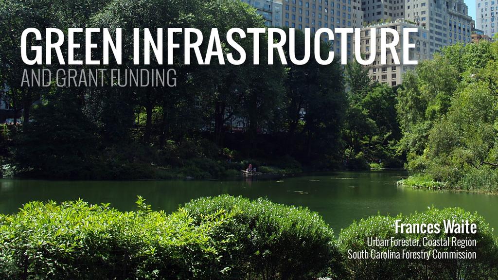
NEW GRANTS PROGRAM. Today I will describe what green infrastructure planning entails, how the model works and the importance of the work to planners!
|
|
|
- Kevin Booker
- 5 years ago
- Views:
Transcription
1
2 NEW GRANTS PROGRAM The South Carolina Forestry Commission received funds from the USDA Forest Service s Southern Region to build a green infrastructure landscape scale model and to fund several implementation projects. The nonprofit firm the Green Infrastructure Center (GIC) was hired to build the model and test it in Berkeley County SC. There is also a planning guide which provides the steps for creating a plan. They also provided the illustrations used in this slide show. Today I will describe what green infrastructure planning entails, how the model works and the importance of the work to planners!

3 NEW PLANNING GUIDE The planning guide we funded provides the steps for creating a plan. It also has the case study presented today in more detail. The Appendix shows how to build a computer model in GIS to create a green infrastructure network. Anyone can use this guide to build their own model and maps! The GIC wrote the guide under out grant. It can be accessed at:

4 SC Grants Projects Awarded Anderson County Darlington County Jasper County Santee-Lynches COG Town of Summerville East Cooper Land Trust (including Town of McClellanville, Town of Awendaw, Town of Mt. Pleasant, City of Isle of Palms, Town of Sullivan s Island, as well as unincorporated sections of Charleston County)

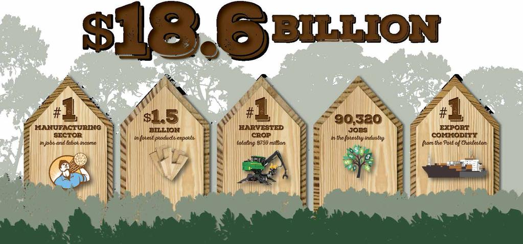
5 OUR FORESTS NEED PROTECTION The state s forested watersheds fulfill a critical resource role as the primary supplier of clean public water. In addition to beautiful landscapes, forests provide clean water and air, wildlife habitat, recreation, carbon storage, and soil protection. South Carolina s forested watersheds are well managed as documented by a 93.4% compliance rating with state water quality guidelines.


6 OUR FORESTS NEED PROTECTION Lands suited for forestry should be considered in land planning. Forests currently occupy 67 percent or 13.1 million acres of the land area in South Carolina. From SC had the 9th fastest rate of land conversion from ag and forest to urban development.

7


8 WE CAN THINK OF OUR FORESTS AND OTHER RESOURCES AS NATURAL ASSETS Includes all landscape elements that support our existence.


9 NATURAL ASSETS ALSO SUPPORT CULTURAL ASSETS

10 OUR NATURAL ASSETS ARE OUR Green Infrastructure! Benefits are Conserving working lands such as farms and forests, that contribute to the economy. Protecting and preserving water quality and supply. Providing cost-effective stormwater management and hazard mitigation. Preserving biodiversity and wildlife habitat. Improving public health, quality of life and recreation networks.


11 OUR NATURAL ASSETS How can we keep the land connected? We can keep land connected with development but only if we plan at a larger scale.
 from total area to get remaining interior habitat. Is it enough to be a core?")
12 CALCULATING INTERIOR FOREST HABITAT Is it a habitat core? Take a distance of 2-3 canopy heights (h) from the edge and multiply times 3. So if your average tree was 100 feet tall, then 100 x 3 = 300 feet. Subtract the edge zone (300 feet) from total area to get remaining interior habitat. Is it enough to be a core? If smaller, it may still be a key patch or site. Interior = Total Area 3(h) Ideal interior 100 acres

13 CALCULATING INTERIOR FOREST HABITAT Division = less habitat Dividing a large core into two smaller cores = less interior habitat and more edge Ideal interior 100 acres


14 EDGE More Edge = More Impacts!

15 CONNECTIONS Species can hop from across patches sometimes

16 CORE LOSS When cores are lost some species may decline


17 CONNECTED LANDSCAPE Cores Need to be Connected by Corridors

18 CORRIDORS Needed to allow movement and survival The ideal is 100 meters of safe space in the middle and 100 meters of edge. minimum width = 300 meters wide


19 STATE HABITAT MODEL Consultants from GIC built us a model to prioritize This project built a model that can be run at any scale from regions to counties. Urban areas may also need tree canopy estimates.

20 CORE RANKINGS Landscape quality varies the model calculates values using several factors
 Water: 16 acres Topographic Diversity: 7.")
21 CORE STATISTICS The i tool tells users the results of each core Core Statistics Use the i tool to query the database for any core i tool Area: 3,673 acres Core Depth: 2,174 feet Species Richness: 143 Soil Diversity: 13 Perimeter/Area Ratio: 66.9 Stream Density: 24.7 ft/acre Wetlands: 1,408 acres (38%) Water: 16 acres Topographic Diversity: 7.12 RTE Species Abundance: 1 RTE Species Diversity: 1

22 PLANNING Once we know the location and quality of landscapes we can apply this knowledge to planning! Zoning Tools and Comp Plans Park and open space planning I.d. lands for PDR or TDR programs New ordinance development Species protection Heritage tourism and viewsheds Easements Transportation plans: roads/trails Land management
23 COMPREHENSIVE PLANNING Maps can inform the comprehensive plan! Article 3: Local Planning -- The Comprehensive Planning Elements Key Elements related to Green Infrastructure (1) inventory of existing conditions; (3) a natural resources element which considers coastal resources, slope characteristics, prime agricultural and forest land, plant and animal habitats, parks and recreation areas, scenic views and sites, wetlands, and soil types. Where a separate board exists pursuant to this chapter, this element is the responsibility of the existing board; (4) a cultural resources element which considers historic buildings and structures, commercial districts, residential districts, unique, natural, or scenic resources, archaeological, and other cultural resources. (7) a land use element which considers existing and future land use by categories, including residential, commercial, industrial, agricultural, forestry, mining, public and quasi-public, recreation, parks, open space, and vacant or undeveloped;
24 SIX STEPS We use a six-step process 1) Set Your Goals: What does your community value? 2) Review Data What do we know or need to know, to map identified values? Combine the state modeled data with local data. 3) Map Your Community s Ecological and Cultural Assets Based on the goals established in Step One and data from Step Two. 4) Risk Assessment What assets are most at risk and what could be lost if no action is taken? 5) Rank Your Assets and Determine Opportunities Based on those assets and risks you have identified, which ones should be restored or improved? 6) Implement Opportunities Include natural asset maps in both daily and long-range planning (park planning, comp plans, zoning, tourism and economic development, seeking easements etc)
25 BERKELEY COUNTY Habitat Cores and Corridors All Habitat Cores (i.e. individual rankings not shown)

26 BERKELEY COUNTY Habitat Cores and Corridors Protected Which lands under easement? Not all lands are protected.


27 BERKELEY COUNTY Habitat Cores and Corridors At Risk Some waters are impaired. Some lands have higher risk of wildfires.
28 BERKELEY COUNTY Protecting the Forest Economy Can show both current forestry activity as well as forest potential based on parcel size, amount and type of forests, etc.

29 WHY DO THIS WORK? Many Benefits of Knowing Where Assets Are Located! Forest cover protects surface water sources and aquifer recharge zones and reduces the cost of drinking water treatment. American Water Works Association found a 10% increase in forest cover reduced chemical and treatment costs for drinking water by 20%. (Ernst et al. 2004) Trees = cheaper water treatment

30 WHY DO THIS WORK? Many Benefits of Knowing Where Assets Are Located! Trees provide more attractive areas for development, historic districts, commercial areas opportunities for people to interact with nature. A study by the University of Washington found that people shopped longer and more often in treelined retail areas and spent about 12 percent more money. Trees = more tax revenue even in developed commercial districts!

31 WHY DO THIS WORK? Many Benefits of Knowing Where Assets Are Located! Small companies, especially those that are have well paid and skilled workforce place a strong importance on the green of the local environment. Crompton Love and Moore, 1997 The creative class: artists, media, lawyers, analysts, make up 30 percent of the U.S. workforce and they place a premium on outdoor recreation and access to nature. Florida, 2002 Key message: Natural assets attract better paid jobs and thus a better tax base = $
 q Clean air trees absorb pollutants, VOCs, filter runoff, cool the city.")
32 WHY DO THIS WORK? Many Benefits of Knowing Where Assets Are Located! q Access to fitness opportunities. (addresses obesity, nature deficit disorders) q Clean air trees absorb pollutants, VOCs, filter runoff, cool the city. (combat asthma) q Well being and mental health - -people heal faster when they can see or access green. (hospitals need this for patients, reduces absenteeism of workers) q Less crime occurs near trees. (issue especially for downtowns and public housing areas) q Employees will exercise if they can access green where they work and on the way to work. (addresses employee health) Key Message: Treed areas = healthy safer communities!
 571-0136 fmwaite@bellsouth.")
33 END Frances Waite Coastal Region Urban Forester SC Forestry Commission (843)

34 BLUEWAYS AND GREENWAYS: PARTNERSHIPS AND WEB MAPPING APPLICATIONS American Planning Association: South Carolina Chapter _ Fall 2015 Conference _ October 15, 2015 _ USS Yorktown Mount Pleasant, South Carolina Ashley Buffington The Graduate School at the College of Charleston Dual Degree Program: Master of Environmental Studies/Master of Public Administration
35 OVERVIEW I. Partnerships i. Berkeley-Charleston-Dorchester Blue Trails Project i. Goals ii. Blueways-Greenways: Developing Examples as Models for Other Communities i. Funding ii. iii. iv. Purpose Goals Deliverables II. Developing A Web Mapping Application i. Features Tools ii. iii. Examples iv. Live Preview
 Partnered with local stakeholders and municipalities to lead the formation of a BCD")

36 BERKELEY-CHARLESTON-DORCHESTER BLUE TRAILS PROJECT Berkeley-Charleston-Dorchester Council of Governments (BCD COG) Awarded Technical Assistance Grant through the Department of Interior s National Park Service (NPS) Partnered with local stakeholders and municipalities to lead the formation of a BCD Regional Blueways Coalition Project Goals: Develop a master plan to attract users to regional waterways and related outdoor recreation Provide education and outreach Protect the area's natural resources Link coordination/planning efforts on waterways Enhance recreation, economic development, environmental stewardship

37 BLUEWAYS-GREENWAYS: DEVELOPING EXAMPLES AS MODELS FOR OTHER COMMUNITIES A South Carolina Sea Grant Consortium (SCSGC) Funded Member Institution Study Group Project Funding $25, % match from College of Charleston Purpose Facilitate contact between S.C. coastal communities and the SCSGC Assist communities lacking ability to start own blueway/greenway projects Engage with communities through outreach and deliverables Dovetail with BCD Blue Trails Project
38 BLUEWAYS-GREENWAYS: DEVELOPING EXAMPLES AS MODELS FOR OTHER COMMUNITIES Primary Goals Develop an example/template of a successful Blueways-Greenways project Provide materials and guidance that can be used to help communities start their own projects Deliverables Brochures General Blueway and Greenway Information How to Get Started including Funding Sources Application/Website (usable on Phones, tablets, and computers) ESRI s Briefing Book Expectations for Project Outcomes Example Proposals/Projects Applications for Grant Funding

39 DEVELOPING A WEB MAPPING APPLICATION Highlighting Trail Systems in the Tri-County Area Providing a User- Friendly Way to Explore Green Infrastructure
40 WEB MAPPING APPLICATION Features Tools (Widgets) Access Points Green Spaces Protected Land Parks Trails Water Trails Land Trails Conditions Stream Gauges Weather Stations Points of Interest National Register Historic Sites Landmarks Lodging Planned Features Water Access Parks About Legend Layer List Bookmarks Draw Directions Search Print Query Select a Zone Locate Access by Water Body Find Nearest: Access Point of Interest Lodging National Register Historic Site Wind Weather Alerts

41 FEATURES OVERVIEW
42 About Legend TOOLS OVERVIEW Layer List Bookmarks Draw


43 DIRECTIONS From one location to another Example: Garris Landing to Mt. Pleasant KOA Zoom In Zoom Out Home Extent My Location

44 QUERY Locate Access Point by Water Body Zoom In Zoom Out Home Extent My Location


45 QUERY 1. Select a Zone 2. Find Nearest Lodging Zoom In Zoom Out Home Extent My Location
46 LIVE APP PREVIEW
47 Contact QUESTIONS OR COMMENTS Ashley Buffington (803) Thank You
Green Infrastructure Policies and Ordinances
 Green Infrastructure Policies and Ordinances October 23, 2013 By Karen Firehock, Green Infrastructure Center 2013 Georgia Urban Forest Council s 23 rd Annual Conference The mission of the nonprofit Green
Green (and blue) Infrastructure Planning in VA
 Infrastructure Planning in VA") Green (and blue) Infrastructure Planning in VA Presentation to Rural Resiliency Forum By Karen Firehock Oct. 23, 2018 Green Infrastructure Center 2018 Slide Show Topics Definitions: Resilience Green Infrastructure
Green (and blue) Infrastructure Planning in VA Presentation to Rural Resiliency Forum By Karen Firehock Oct. 23, 2018 Green Infrastructure Center 2018 Slide Show Topics Definitions: Resilience Green Infrastructure
Conservation Corridor Planning and Green Infrastructure Themes
 Conservation Corridor Planning and Green Infrastructure Themes Prepared by the Green Infrastructure Center Inc. and the Northern Virginia Regional Commission February 22, 2011 Brief Overview Project Background
Blue/Green Infrastructure Study Accomack County, VA
 Blue/Green Infrastructure Study Accomack County, VA Draft Asset Maps March 8-9, 2010 Green Infrastructure Center, Inc. 2 Overview What is Green and Blue Infrastructure Project Timeline & Tasks Literature
Green Infrastructure. by Karen Engel, NYS DEC. NYS Department of Environmental Conservation
 Green Infrastructure by Karen Engel, NYS DEC What is Green Infrastructure? For some it s all about water Green Infrastructure techniques use soils and vegetation to infiltrate, evapotranspirate, and/or
Conservation Corridor Base and Thematic Maps
 Conservation Corridor Base and Thematic Maps August 20, 2010 This project is funded in part by the Virginia Coastal Zone Management Program at the Department of Environmental Quality through Grant #NAO9NOS4190163
Mapping and Planning for Green Infrastructure
 Mapping and Planning for Green Infrastructure Karen Firehock, Executive Director TransportiCA Webinar Series August 30, 2018 Today 1. Green infrastructure defined 2. Mapping green infrastructure in rural
NACCED/NACo CONFERENCE JULY 10, 2015
 NACCED/NACo CONFERENCE JULY 10, 2015 Regional Growth Framework 2 Regional Growth Framework Regional Priorities Preferred Growth Concept Tools to Support Local Governments 3 Top Priorities for the CONNECT
Community Conservation Workshop. Saranac River Basin Communities
 Community Conservation Workshop Saranac River Basin Communities 2 Community Conservation Program Welcome! We have designed a Community Conservation Program that listens to the needs of community members.
This page intentionally blank.
 This page intentionally blank. Parks, Recreation, and Open Space Chapter Relationship to Vision Vision Parks, Recreation and Open Space Chapter Concepts County Government. County government that is accountable
SUSTAINABILITY PLAN OTTAWA COUNTY PARKS AND RECREATION COMMISSION FALL 2017
 SUSTAINABILITY PLAN OTTAWA COUNTY PARKS AND RECREATION COMMISSION FALL 2017 Table of Contents Introduction Natural Resources Quality of Life Community Continuing the Mission Sustainability Measuring Sustainability
Green Planning in Albemarle and Charlottesville
 Green Planning in Albemarle and Charlottesville Presentation to League of Women Voters February 10, 2019 By Karen Firehock, Executive Director Green Infrastructure Center 2019 The Green Infrastructure
495/MetroWest Development Compact Plan Citizen Planner Training Collaborative Conference. March 17, 2012
 495/MetroWest Development Compact Plan Citizen Planner Training Collaborative Conference March 17, 2012 Project Process Local and Regional Priority Areas Growth Scenarios Transportation Investment Categories
Preface. Erie. Scranton. Allentown. Pittsburgh. Harrisburg. Philadelphia
 The Southern Alleghenies Region The Southern Alleghenies Region spans the Laurel Highlands and Allegheny Front in the west across the Appalachians to the east. It is comprised of Blair, Bedford, Cambria,
I. STAFF POLICY RECOMMENDATIONS. The following RMP policy strategies are proposed by staff in support of a Scenic Resource Protection Program:
 Policy Consideration: Scenic Resource Protection Program Status: For Consideration by the Highlands Council at September 14, 2006 Work session Date: September 12, 2006 I. STAFF POLICY RECOMMENDATIONS The
RECREATION, OPEN SPACE AND GREENWAYS ELEMENT GOALS, OBJECTIVES, AND POLICIES
 RECREATION, OPEN SPACE AND GREENWAYS ELEMENT GOALS, OBJECTIVES, AND POLICIES GOAL R-1: DEVELOP A RECREATION, OPEN SPACE AND GREENWAYS SYSTEM AS AN INTEGRAL COMPONENT OF AN OVERALL, COUNTY-WIDE ECONOMIC
Community Conservation Workshop. Lake Placid
 Community Conservation Workshop Lake Placid 2 Community Conservation Program Welcome! We have designed a Community Conservation Program that listens to the needs of community members. We are conducting
Planning for and Managing Open Space and Natural Areas
 Planning for and Managing Open Space and Natural Areas Increasingly, development proposals in Delaware include large amounts of open space and natural areas. While open space is important as a community
Summary of Action Strategies
 Strategic Action Plan 6 Summary of Action Strategies Action Strategy Categories: 1. Organization and Management 2. Implementation 3. Marketing and Promotion This chapter summarizes all of the action strategies
Countywide Green Infrastructure
 Montgomery County s Countywide Green Infrastructure F U N C T I O N A L M A S T E R P L A N The Maryland National Capital Park and Planning Commission INFRASTRUCTURE An underlying base or foundation especially
10.0 Open Space and Public Realm
 10.0 Open Space and Public Realm 10.0 Open Space and Public Realm The Public Open Space System is comprised of: outdoor spaces available for public use that are either publicly owned (e.g., parks and
Green Infrastructure. NYS Department of Environmental Conservation
 Green Infrastructure Green infrastructure is an interconnected network of natural areas and open spaces that sustains ecosystems. Benedict, M.A. and E.T. McMahon. 2006. Green Infrastructure Linking Landscapes
Outdoor Recreation and Conservation Careers Toolkit WEBINAR: OUTDOOR RECREATION AND CONSERVATION CAREERS TOOLKIT 1
 Outdoor Recreation and Conservation Careers Toolkit WEBINAR: OUTDOOR RECREATION AND CONSERVATION CAREERS TOOLKIT 1 The Outdoor Recreation Economy accounts for $646 billion in consumer spending annually
Riparian Buffer on the Bushkill Creek. Policies
 Riparian Buffer on the Bushkill Creek Riparian buffers provide numerous benefits to landowners and the community by protecting groundwater recharge areas, providing flood control, providing stormwater
3.9 Systems Interrelationships
 191 Sustainability Building Blocks: The Comprehensive Plan Systems Community Form Economy Social Transportation Natural Resources Housing and Neighborhoods Utilities and Infrastructure Institutions.9 Systems
Map Development 5/15/2012. New Virginia Modeling Tools
 Regional Green Infrastructure Base Map Development 5/15/2012 RRRC Land Use & Environment Committee New Virginia Modeling Tools VA Natural Landscape Assessment Forest Habitats Cultural Model Historic Resources
Chapter 2: Strategies for Local Governments Chapter 3: Site Assessment and Design for Low Impact Development. Break Out Group 10:30 am to 12 pm
 Chapter 2: Strategies for Local Governments Chapter 3: Site Assessment and Design for Low Impact Development Break Out Group 10:30 am to 12 pm A Low Impact Development Manual for Coastal South Carolina
Whitemarsh Township Greenway Plan
 Whitemarsh Township Greenway Plan Prepared for: Whitemarsh Township August 16, 2007 Table of Contents Table of Contents... i Introduction... 1 Study Area Setting... 2 Regional Setting... 2 Township Character...
Green Infrastructure Planning for Sustainability and Resiliency
 Green Infrastructure Planning for Sustainability and Resiliency Linking Lands and Communities in the Land-of-Sky Region SAMAB Conference - November 18, 2010 www.linkinglands.org Linda Giltz, AICP, Regional
National Association of Conservation Districts. Kris Hoellen Vice President, Sustainable Programs The Conservation Fund September 19, 2013
 National Association of Conservation Districts Kris Hoellen Vice President, Sustainable Programs The Conservation Fund September 19, 2013 Our Mission The Conservation Fund forges partnerships to conserve
TOWN OF SPRINGFIELD, NEW HAMPSHIRE
 TOWN OF SPRINGFIELD, NEW HAMPSHIRE NATURAL RESOURCES INVENTORY EXECUTIVE SUMMARY March 2008 Prepared by: Watershed to Wildlife, Inc. Natural Resource Consultants 42 Mill Street, Suite 3 Littleton, NH 03561
Using Green Infrastructure Planning To Support And Enhance Healthy Ecosystems and Communities
 Using Green Infrastructure Planning To Support And Enhance Healthy Ecosystems and Communities by Karen Firehock, Executive Director Green Infrastructure Center Inc. www.gicinc.org A Presentation to Master
OPEN SPACE CHAPTER 7: OVERVIEW. Preserve open space to protect natural resources, enhance character and provide passive recreation opportunities
 CHAPTER 7: OPEN SPACE OVERVIEW Ridgefield has made tremendous progress permanently preserving areas of town as open space. Open space preservation can serve many important purposes, including: protect
Sectoral workshop on Green infrastructure implementation. Multiple benefits of Green Infrastructure
 Sectoral workshop on Green infrastructure implementation Multiple benefits of Green Infrastructure Kristin Faurest Arad October 2015 Contents Green infrastructure as an integrated solution: social, ecological
What Planners Do. Heather Wade, Coastal Planning Specialist Texas Sea Grant
 What Planners Do Heather Wade, Coastal Planning Specialist Texas Sea Grant What Planners Do Seminar Series Department of Landscape Architecture and Urban Planning College of Architecture ABOUT ME B.S.
Sorted citizen input comments in review of Blount County plans July, August, and September 2007
 Sorted citizen input comments in review of Blount County plans July, August, and September 2007 The following presents sorted citizen input comments from three sessions held in July, August and September
Presentation Outcomes
 Green Infrastructure Rappahannock-Rapidan Living Lands Planning Workshop September 17, 2009 Presentation Outcomes Define green infrastructure principles and concepts (video). How are green infrastructure
TOWN OF BETHLEHEM OPEN SPACE CONSERVATION PLAN PUBLIC MEETING: OCTOBER 12, 2017
 TOWN OF BETHLEHEM OPEN SPACE CONSERVATION PLAN PUBLIC MEETING: OCTOBER 12, 2017 Welcome and Agenda 6:00 6:45: Open House, Part One 6:45 7:15: Presentation and Questions 7:15 8:00: Open House, Part Two
SCORP THE 2019 STATEWIDE COMPREHENSIVE OUTDOOR RECREATION PLAN EXECUTIVE SUMMARY
 THE 2019 STATEWIDE COMPREHENSIVE OUTDOOR RECREATION PLAN EXECUTIVE SUMMARY SCORP Statewide Comprehensive Outdoor Recreation Plan 1 December 11, 2018 Dear Fellow Coloradans, It gives me great pleasure to
TABLE OF CONTENTS. Transportation Chapter 1 - Introduction and Purpose of Planning to 1-3. Utilities
 Chapter 1 - Introduction and Purpose of Planning... 1-1 to 1-3 Pennsylvania Municipalities Planning Code (Act 247)...1-1 Previous County Planning Activities...1-1 Objectives of the Plan...1-2 Elements
Member Service Plan Sierra Nevada AmeriCorps Partnership
 Member Service Plan Sierra Nevada AmeriCorps Partnership Service plans lay the framework for what each Member will be doing during their service. Service plans detail the major projects and expected results
20 International Conference of The Coastal Society THE ROLE OF PLANNED UNIT DEVELOPMENTS IN ENVIRONMENTAL MANAGEMENT IN THE COASTAL ZONE
 th 20 International Conference of The Coastal Society THE ROLE OF PLANNED UNIT DEVELOPMENTS IN ENVIRONMENTAL MANAGEMENT IN THE COASTAL ZONE Kathleen E. Semon, University of South Carolina Braxton C. Davis,
Stacey Isaac Berahzer
 Innovative Financing Approaches for Stormwater and Green Infrastructure - Elected & Appointed Officials Stormwater Lunch & Learn Stacey Isaac Berahzer Senior Project Director Environmental Finance Center
GIS to Estimate Archaeological Site Loss and Develop Conservation Strategies
 GIS to Estimate Archaeological Site Loss and Develop Conservation Strategies Terry Jackson Office of Decision Support Systems Planning and Environmental Management Division Georgia Department of Community
Regional Context Statement
 Regional Context Statement REGIONAL CONTEXT STATEMENT 3. REGIONAL CONTEXT STATEMENT In 1995, the Provincial Government passed into law the Growth Strategies Act. The purpose of this provincial initiative
Figure 1. Proposed Strategic Habitat Conservation Areas for Florida
 Figure 1. Proposed Strategic Habitat Conservation Areas for Florida Critical Lands and Waters Identification Project (CLIP) Cooperative Effort Century Commission for Sustainable Florida Florida Natural
Arlington, Virginia is a worldclass
 EXECUTIVE S U M M A RY Arlington maintains a rich variety of stable neighborhoods, quality schools and enlightened land use policies, and received the Environmental Protection Agency s highest award for
{Best Practices. Summary of Tools, Strategies and Best Practices from 11 Michigan Case Study Communities
 Case Studies Michigan Coastal Community Working Waterfronts { Summary of Tools, Strategies and from 11 Michigan Case Study Communities Table of Contents Zoning...2 Community and Stakeholder Collaboration
Bay County RESTORE Act Direct Component Proposals The project will encompass all of Unincorporated Bay County as a whole.
 Proj # Bay PRP 2014-016 Project Name Bay County Master Plan and Capital Improvement Strategic Plan Update Project Proposer, affiliation, web site Project Description Proj. Size (acres) Economic Environmental
A BLUEPRINT FOR BROCKTON A CITY-WIDE COMPREHENSIVE PLAN
 A BLUEPRINT FOR BROCKTON A CITY-WIDE COMPREHENSIVE PLAN Public Meeting October 2016 1 Plan Summary and Discussion Public Meeting May 4 2017 City of Brockton Bill Carpenter, Mayor Department of Planning
Learning from Other Communities Western Nassau Heritage Preservation Committee Nassau County Planning + Zoning Board May 1, 2018
 Learning from Other Communities Western Nassau Heritage Preservation Committee Nassau County Planning + Zoning Board May 1, 2018 Overview ULI Report References Other Florida Communities Communities Outside
Smart Growth for Dallas
 Smart Growth for Dallas Using data and GIS to improve the social, economic, and environmental resilience of Dallas Dallas Park and Recreation Board November 1, 2018 About Our Partners The Trust for Public
Midtown Greenway PROJECT REPORT CARD
 Midtown Greenway PROJECT REPORT CARD Project Overview and History The Midtown Greenway is a 5.5-mile multi-use trail that connects the Mississippi River to the Minneapolis Chain of Lakes. The corridor,
South Central Connecticut Region Plan of Conservation & Development 2018 Update. Municipal Planners
 South Central Connecticut Region Plan of Conservation & Development 2018 Update Municipal Planners July 28th, 2017 1 Introductions 2 Purpose of Today s Meeting Supplement data analysis with qualitative
CHAPTER 4 FUTURE LAND USE AND URBAN SERVICES DISTRICTS
 CHAPTER 4 FUTURE LAND USE AND URBAN SERVICES DISTRICTS Introduction This chapter discusses how Benzie County should grow and change in the future. A community can grow and change in many different ways.
Scottish Natural Heritage Sharing Good Practice Programme
 Scottish Natural Heritage Sharing Good Practice Programme January December 2018 Sharing Good Practice is a unique programme of events for people from a wide variety of sectors, including land managers,
C. Guinn Garrett 1, Kimberly A. Counts 2, Blaik P. Keppler 3, April Turner 4
 A 6,000 Stormwater Pond Task: Meeting the Needs of Diverse Audiences for Stormwater Pond Management Outreach in the Berkeley, Charleston and Dorchester Communities C. Guinn Garrett 1, Kimberly A. Counts
DRAFT FOR PUBLIC REVIEW. Game Plan for a Healthy City
 DRAFT FOR PUBLIC REVIEW 2018 Game Plan for a Healthy City 2 Denveright. Parks & Recreation Game Plan Draft for Public Review Draft for Public Review Executive Summary Game Plan Overview Executive Summary
Woodland Conservation and the Master Plan
 1 WHAT IS A MASTER PLAN? A Vision for the Future of Your Community Woodland Conservation and the Master Plan Goals Objectives Strategies 2 How Will Your Community Look? TREE PRESERVATION AND THE MASTER
Town of Peru Comprehensive Plan Executive Summary
 Town of Peru Comprehensive Plan Executive Communities that plan grow by choice, not by chance. A plan makes growth thoughtful, understandable, and predictable. A plan shows that a community is managing
IMPLEMENTING SOMERSET COUNTY S INVESTMENT FRAMEWORK
 IMPLEMENTING SOMERSET COUNTY S INVESTMENT FRAMEWORK SMART CONSERVATION THROUGH SMART GROWTH NJ LAND CONSERVATION RALLY March 22, 2014 Laurette Kratina, PP, AICP, Supervising Planner Somerset County Planning
SALISBURY TOMORROW Our Vision
 SALISBURY TOMORROW Our Vision Salisbury is committed to supporting a high quality of life and sense of community for all residents. These commitments need to be reflected in our community programs, services
Karen Firehock. Strategic. Green Infrastructure. Planning. a multi-scale approach
 Karen Firehock Strategic Green Infrastructure Planning a multi-scale approach STRATEGIC GREEN INFRASTRUCTURE PLANNING STRATEGIC GREEN INFRASTRUCTURE PLANNING: A multi-scale approach By Karen Firehock
Pennsylvania Stormwater Best Management Practices Manual. Chapter 1. Introduction and Purpose
 Pennsylvania Stormwater Best Management Practices Manual Chapter 1 Introduction and Purpose Chapter 1 Introduction and Purpose 1.1 Purpose of this Manual 1 1.2 How to Use this Manual...1 1.3 Overview
STEWARDSHIP OF LONG ISLAND SOUND S ECOLOGICAL AND RECREATIONAL RESOURCES
 STEWARDSHIP OF LONG ISLAND SOUND S ECOLOGICAL AND RECREATIONAL RESOURCES Robin Kriesberg, Save the Sound, Inc. Thomas Halavik, US Fish and Wildlife Service Coastal Program An Initiative to Identify, Protect
Yadkin River Greenway Feasibility Study Fact Sheet Village of Clemmons, Town of Lewisville, Town of Bermuda Run
 Fact Sheet Village of Clemmons, Town of Lewisville, Town of Bermuda Run Project Background The Yadkin River Greenway Feasibility Study is a joint project with the Village of Clemmons, the Town of Bermuda
G. RECREATION AND OPEN SPACE ELEMENT. The following summarizes the Recreation and Open Space Element:
 G. RECREATION AND OPEN SPACE ELEMENT The purpose of the Element is to provide the framework and direction for a comprehensive system of public and private sites for recreation, including, but not limited
Turkey Creek Streamway Corridor
 Turkey Creek Streamway Corridor Turkey Creek Corridor Overview History Watershed Corridor Inventory Coalition Corridor Plan Stages of Development Benefits Funding Turkey Creek History Kansas and Missouri
NASSAU COUNTY TOWN HALL NEW YORK & CONNECTICUT SUSTAINABLE COMMUNITIES. A Unique Bi-State Partnership to Improve Jobs, Housing and Transportation
 NASSAU COUNTY TOWN HALL NEW YORK & CONNECTICUT SUSTAINABLE COMMUNITIES A Unique Bi-State Partnership to Improve Jobs, Housing and Transportation Police Headquarters Auditorium Mineola, NY December 9 th,
CHAPTER 1 Introduction
 CHAPTER 1 Introduction From sea to summit, Lane County covers almost 4,800 square miles of diverse Oregon landscape. Stretching from the Pacific Ocean through the Coastal Range, the Willamette Valley to
City of Tacoma Planning and Development Services
 Agenda Item D-1 City of Tacoma Planning and Development Services To: Planning Commission From: Elliott Barnett, Planning Services Division Subject: Application #2014-08 Open Space Element Update Meeting
ADOPTION OF THE REVISED OPEN SPACE AND CONSERVATION ELEMENT OF THE GENERAL PLAN
 TO: FROM: SUBJECT: Honorable Mayor and City Council Planning Department ADOPTION OF THE REVISED OPEN SPACE AND CONSERVATION ELEMENT OF THE GENERAL PLAN RECOMMENDATION: It is recommended that the City Council:
Environment and Natural Resources Trust Fund 2009 Phase 2 Request for Proposals (RFP)
") Environment and Natural Resources Trust Fund 2009 Phase 2 Request for Proposals (RFP) LCCMR ID: 023A1 Project Title: Olmsted County's Decorah Edge Total Project Budget: 103,380 Proposed Project Time Period
Environment and Natural Resources Trust Fund 2009 Phase 2 Request for Proposals (RFP) LCCMR ID: 023A1 Project Title: Olmsted County's Decorah Edge Total Project Budget: 103,380 Proposed Project Time Period
Regional Plan for Sustainable Development
 Regional Plan for Sustainable Development Final Plan Outline Western Greater Yellowstone Consortium Annual Summit May 7, 2014 Regional Plan for Sustainable Development (RPSD) Is intended to serve as a
COMMUNITY ENVIRONMENTAL MANAGEMENT
 COMMUNITY ENVIRONMENTAL MANAGEMENT CEM HANDBOOK FOR COMMUNITY CONSERVATION PLANNING ----- Draft ----- Prepared by the CENTER FOR COMMUNITY ENVIRONMENTAL MANAGEMENT in association with the NEW YORK STATE
Portage County Parks, Trails and Greenways Plan
 Portage County Parks, Trails and Greenways Plan Agenda for Local Planning Meeting Introductory Presentation Why we need a Plan Plan project goals and process Benefits Overview of local planning region
City of Lake Mary, Florida. Evolution of a Historic Downtown with Transit Oriented Development Strategies
 City of Lake Mary, Florida Evolution of a Historic Downtown with Transit Oriented Development Strategies What is Transit Oriented Development? Walkable villages located at and around transit stations in
The transportation system in a community is an
 7 TRANSPORTATION The transportation system in a community is an important factor contributing to the quality of life of the residents. Without a sound transportation system to bring both goods and patrons
Minnesota Department of Natural Resource - Natural Resource Guidance Checklist Conserving Natural Resources through Density Bonuses
 Minnesota Department of Natural Resource - Natural Resource Guidance Checklist Conserving Natural Resources through Density Bonuses NRDB Why Use Density Bonuses & This Checklist Local units of government
Western Pennsylvania Conservancy Clairton & Harrison Community Greening Assessment Projects Request for Proposals July 2018
 Western Pennsylvania Conservancy Clairton & Harrison Community Greening Assessment Projects Request for Proposals July 2018 Proposal Information The Western Pennsylvania Conservancy (WPC) is seeking proposals
Staff will be providing an overview of the project need, purpose and intent for consideration as part of the Amendment cycle.
 Agenda Item D-2 City of Tacoma Planning and Development Services To: Planning Commission From: Stephen Atkinson, Planning Services Division Subject: Open Space Corridors Project Meeting Date: March 1,
Parks, Open Space and Trails
 Introduction Parks have often been referred as the lungs of our cities, cleansing the air of pollutants and particulate matter. Parks are also gathering places for families and community. They offer spaces
THREE-STEP DESIGN PROCESS FOR OPEN SPACE SUBDIVISIONS
 00216106.DOC NMA/RRK 1/30/14 THREE-STEP DESIGN PROCESS FOR OPEN SPACE SUBDIVISIONS Open space subdivisions, sometimes called cluster developments, maintain a significant portion of a development site in
Concord Community Reuse Project Goals and Guiding Principles. Overarching Goals (OG)
") Concord Community Reuse Project Goals and Guiding Principles Overarching Goals (OG) No priority is implied by the order of presentation of the goals and guiding principles. Overarching goals for the Concord
Concord Community Reuse Project Goals and Guiding Principles Overarching Goals (OG) No priority is implied by the order of presentation of the goals and guiding principles. Overarching goals for the Concord
Office of Greenways & Trails Providing Statewide Leadership and Coordination. Southeast Greenways and Trails Summit October 1-3, 2017
 Office of Greenways & Trails Providing Statewide Leadership and Coordination Southeast Greenways and Trails Summit October 1-3, 2017 1 Office of Greenways and Trails The Office of Greenways and Trails
Land Use Regional Planning in Alberta Collaborating with Stakeholders
 Land Use Regional Planning in Alberta Collaborating with Stakeholders Trevor Lema, Land & Integrated Management Planner September 2018 Overview Why Regional Planning? An Integrated Perspective Integrated
We provide exceptional solutions to help our clients achieve success.
 We provide exceptional solutions to help our clients achieve success. We began as a small, two-person surveying firm called M.E. Berry & Associates in Hollywood, Florida. Known today as Calvin, Giordano
Master Plan Objectives and Policies
 Master Plan Objectives and Policies Introduction This chapter identifies the Park issues and recommended policies established by this Master Plan. The issues were identified through meetings with staff,
DLR Open Space Strategy. Final Draft Report April 2010
 I DLR Open Space Strategy Final Draft Report April 2010 Urban parks and green spaces are an essential part of the urban heritage and infrastructure, being a strong element in the architectural and landscape
Florida Forever Conservation Needs Assessment Overview Maps
 Florida Forever Conservation Needs Assessment Overview Maps Prepared by Florida Natural Areas Inventory, The maps in this document are derived from the Florida Forever Conservation Needs Assessment, an
Natural Capital City Model - Birmingham
 Nick Grayson Climate Change & Sustainability Manager Birmingham City Council April 29 th 2013 Metanoia EKN- Putting nature s services on the map April 29 th 2013 - Oxford Sustainability Forum June 11 th
Chapter 3. Community Vision and Goals
 Chapter 3. Community Vision and Goals 3.1 Public Involvement Charlevoix s master plan was prepared in a way that maximized public participation. Dating back to 2004, the Planning Commission and staff held
But What About the People? The Role of Urban Planning and Green Infrastructure
 But What About the People? The Role of Urban Planning and Green Infrastructure The Southeast Conservation Adaptation Strategy: A Model for Collaborative Conservation David Rouse, FAICP, ASLA Managing Director,
FOREST SERVICE MANUAL NATIONAL HEADQUARTERS (WO) WASHINGTON, DC
 WASHINGTON, DC") Page 1 of 11 FOREST SERVICE MANUAL NATIONAL HEADQUARTERS (WO) WASHINGTON, DC FSM 2300 RECREATION, WILDERNESS, AND RELATED RESOURCE MANAGEMENT Amendment No.: 2300-2011-2 Effective Date: October 19, 2011
Page 1 of 11 FOREST SERVICE MANUAL NATIONAL HEADQUARTERS (WO) WASHINGTON, DC FSM 2300 RECREATION, WILDERNESS, AND RELATED RESOURCE MANAGEMENT Amendment No.: 2300-2011-2 Effective Date: October 19, 2011
Green Infrastructure and Adaptive Management
 Green Infrastructure and Adaptive Management A New Synergy One Water August 27, 2014 Tina Wolff, PE Imagine 1 23 September the result 2014 Prepared by the Green Infrastructure Implementation Task Force
Rural Land Use Designations Kittitas County December 6, 2007 Draft
 KITTITAS COUNTY COMMUNITY DEVELOPMENT SERVICES 411 N. Ruby St., Suite 2, Ellensburg, WA 98926 CDS@CO.KITTITAS.WA.US Office (509) 962-7506 Fax (509) 962-7682 Rural Land Use Designations Kittitas County
Executive Summary Purpose of the Plan Defining Open Space and Greenways
 Executive Summary Bucks County possesses a vast array of open space resources including natural areas, parks, farmland and historic and cultural resources that contribute to a high quality of life valued
INTRODUCTION Key Issues and Findings Goals, Objectives, and Policies - Natural Resources - Map M18 - Environmental Resources
 Natural, Environmental, Cu INTRODUCTION This Element provides policies related to the preservation and protection of the Centre Region s natural, environmental, cultural, and historic resources. This Element
Best Practices Appendix: Waterfront Communities
 Redevelopment Ready Communities Best Practices Appendix: Waterfront Communities revised September 2014 Waterfront RRC defined The purpose of these additional criteria is to provide waterfront communities
Westmoreland County Greenways Plan
 Westmoreland County Greenways Plan Citizens Advisory Board Review Draft April 2007 Prepared for: Westmoreland County and Smart Growth Partnership of Westmoreland County Prepared by: Environmental Planning