Prioritizing Vacant Urban Property for Green Infrastructure SG Final Report
|
|
|
- Leo Wheeler
- 5 years ago
- Views:
Transcription


1 Prioritizing Vacant Urban Property for Green Infrastructure SG Final Report Toledo Metropolitan Area Council of Governments February 2016 This project was funded through the Lake Erie Protection Fund with matching funds provided by members of thetmacog Stormwater Coalition. The LEPF is supported by the voluntary contributions of Ohioans who purchase the Erie Our Great Lake license plate featuring the Marblehead lighthouse.
2 ABSTRACT Lake Erie s western basin and its tributaries have exhibited the effects from a variety of point and nonpoint source pollutants. In most urbanized areas in the watershed, stormwater pollution is a primary cause of impairment resulting in high pollutant and sediment loads and stream flashiness caused by large volumes of stormwater running off of impervious surfaces. Toledo, Ohio at the mouth of the Maumee River on the shores of Lake Erie has experienced the consequences of water quality issues, most notably in 2014 when algae blooms caused microcystis levels that exceeded the Toledo Water treatment plant s ability to provide drinking water to over 500,000 of the region s residents. The City of Toledo also has concentrated blight in many areas with some neighborhoods experience vacancy rates of over 40%. These vacant lots are plagued with overgrown weeds and Illegal dumping, which attract pests, encourage crime, and contribute to cycles of neighborhood disinvestment. Through this project, TMACOG hopes to influence water quality improvement and neighborhood revitalization by encouraging the installation of green stormwater infrastructure (GSI) on vacant blighted properties. GSI manages stormwater by promoting infiltration and reducing runoff volumes. These practices treat pollutants and prevent flooding while also providing beautiful spaces to live work and play. Well placed investments in GSI can stimulate economic reinvestment, provide educational and job opportunities. Using GIS analysis tools and in partnership with many local stakeholders, TMACOG has identified opportunities to convert vacant lots from eyesores to community assets. KEY FINDINGS AND OUTCOMES The goal of the project was to provide priority locations that will be readily available for greening when funds become available through funded public works projects, street improvements, and outside grants. Vacant lots owned by the Lucas County Land Bank or the City of Toledo offer the greatest potential for greening due to the ability of these public entities to implement greening without property acquisition or easement. Although Lucas County has over 25,000 lots identified as vacant in the Auditor s parcel database, AREIS, only about 2,100 of these are publically owned. In all, Lucas County has about 410 acres of publically owned vacant lots, primarily centered in the City of Toledo. Through suitability analysis, we found that 187 acres are highly suitable for green infrastructure, 53 acres are highly suitable for smaller rain gardens, 211 acres are highly suitable for constructed wetlands, and 112 acres are highly suitable for natural area restoration. In addition to the identification of greening opportunities on vacant lots, an impactful outcome of this project was the partnerships that were developed and strengthened over the course of the project term. The effects of collaboration can already be seen in the pooling of resources, funding, community expertise, and institutional knowledge to begin implementation of green infrastructure projects to benefit communities and water quality.
3 TECHNICAL REPORT Activities The primary activities funded under this project were suitability analysis and mapping of the vacant lots across Lucas County to identify underutilized land that can be used for green stormwater management. The project also funded the installation of a green infrastructure practice to demonstrate the process of taking an abandoned home through the process of demolition to an attractive, functional green space. Timeline The project was completed according to the proposed timeline with the exception of the installation of the proof of concept green infrastructure. Due to timing of site selection and growing season constraints, the project end date was extended from March 2015 to December Below is a summary of activities throughout the project term. Quarter 1 activities (April-June 2014) TMACOG invited participation and assembled a group of stakeholders in the project advisory committee. Stakeholders included staff from USDA NRCS, University of Toledo, the Lucas County Land Bank, the City of Toledo, Ohio EPA, Lucas County Sustainability Office, American Rivers, and private consulting firms. The group continued to meet throughout the project term to discuss project goals, priorities, and coordination of project activities. Quarter 2 activities (July-Sep 2014) In-depth landscape scale analysis identified the most suitable areas in Lucas County for various types and scales of green infrastructure, suitability values were assigned to each vacant parcels and each parcel was further ranked based on its property characteristics. This allowed us to identify green infrastructure practices that would be feasible at each site. Quarter 3 activities (Oct-Dec 2014) The demonstration installation was planned for quarter 3, but due to logistical constraints including the timing of site selection, property demolition schedule, and the planting season window, a project extension was requested. This allowed considerably more time to work on design and hire a contractor. Work during this period also involved refining the suitably analysis for each practice on each vacant parcel. The overall scoring was then simplified to a qualitative score that would more easily be used by the general public and decision-makers alike. Quarter 4 activities (Jan-March 2015) Several deliverables were completed during this period: 1) Web-based mapping that includes links to additional resources for implementation. Map and list of suitable sites for GI installation and lists of appropriate GI structures. 2) GIS data (shapefiles) were cleaned and simplified for ease of use by local agencies and the Land bank. 3) A flow chart model of the process used to select sites
 - TMACOG was notified of additional funding that PCS would offer to the proof of concept rain garden.")

4 Additionally, during this period, TMACOG applied for additional funding from Partners for Clean Streams to supplement work on the proof of concept installation. Project extension activities (April December 2015) - TMACOG was notified of additional funding that PCS would offer to the proof of concept rain garden. This period was spent designing a small bioretention area, working with residents on additional green space features, and securing a contract for installation. The installation occurred in November. Project methods Identify Green Infrastructure - The Advisory Committee also identified the types of green infrastructure that should be considered for use on vacant lots. Due to the large number of possible green infrastructure types, practices were aggregated based on general green infrastructure characteristics, scale, and function. The analysis was conducted for the following main green infrastructure types: Small Lot Greening This group of practices is typically best for small lots adjacent to occupied buildings to manage rainwater from roofs, driveways and sidewalks. This includes residential scale rain gardens, rain barrels, downspout redirection to grassy areas, and other practices with little engineering. Maintenance on these smaller greening practices is no more intensive than what is typically required for similar sized residential landscaping, making them ideal for homeowners and community groups. Green Stormwater Infrastructure (GSI) These practices are best suited for redevelopment or retrofit scenarios and pair well with commercial buildings, community centers, schools, and public infrastructure improvements. These practices have the best outcomes when maintenance responsibility is identified before installation. Bioretention areas, bioswales, permeable pavements, and other GSI practices are engineered to manage rainwater from roofs, roads, parking lots, and other impervious surfaces. GSI typically requires more intensive maintenance than smaller scale practices, so a specified inspection and maintenance program along with training is recommended.


5 Constructed Stormwater Wetlands Although stormwater wetlands are a type of GSI, they require a different set of siting requirements from the other GSI practices to accommodate larger footprints and to ensure adequate base flow. They also typically manage rainwater from a larger drainage area and are seminatural areas in that they can offer habitat benefits. Like other GSI, constructed stormwater wetlands require more intensive maintenance than smaller scale practices. Natural Area Restoration Some of the largest vacant parcels can be utilized for permanent restoration of ecological function, maximizing the landscape's natural ability to manage rainwater. This type of greening includes the restoration of natural meadows, floodplains, wetlands, stream hydrology, and tree canopy and offers many additional benefits beyond stormwater management. Ecological restoration can also include plans for parks, bike trails, and stream access. The maintenance requirements are specific to each area and require long-term commitment to resource management and protection through conservation easements. Process for Suitability Analysis Identify site selection criteria Lucas County has over 25,000 parcels coded vacant in the ARIES 2014 auditor s property database and an additional 600 properties were slated by the Land Bank for building demolition in Spatial analysis was used to help identify on which of the vacant parcels greening would be feasible and necessary. Due to the need to have land in public ownership when opportunities for funding green infrastructure arise, the advisory committee identified property ownership as the most important factor in determining a lot s suitability for greening. Other parcel characteristics such as demolition status, lot size, and type of basement helped to identify the most immediate opportunities for greening. The group identified a list of additional landscape scale criteria important in site selection including existing stormwater infrastructure, vacancy rates, imperviousness, soil types, flooding complaints, and future land use plans (See Attachment 1 for complete prioritization criteria, ranking, and weights). A comprehensive list was created and ranked for overall importance in decision-making. Criteria without


6 reliable data or that are generally not applicable to landscape scale decision-making were eliminated from the analysis. Maps with many of the evaluation criteria are shown in the figures below.


7 Suitability Analysis The suitability analysis was composed of both a landscape scale analysis and a parcel analysis. The first steps in GIS analysis involved compiling data identified by the advisory
8 committee, visual inspection of data and aerial photos, and pre-processing of Lucas County Auditor s parcel data. The analysis was completed based on the ranking of criteria by the project advisory team and the siting criteria found in the American Rivers Low Impact Development Manual for the Lower Maumee and Ottawa River Watersheds and the Ohio Department of Natural Resources Rainwater and Land Development Manual. Landscape scale analysis
9 In-depth landscape scale analysis utilized ArcGIS Spatial Analyst to process raster layers and to identify the most suitable areas in Lucas County for the four types and scales of green infrastructure. Data preprocessing involved converting all shapefiles to from a vector format to raster. All raster datasets were then resampled to a 10 meter resolution. Using the Reclassify function in ArcToolbox, the features of each dataset were assigned a criteria ranking score on a 1-10 scale with 1 being the least suitable features and 10 being the most suitable. The Arc GIS Map Algebra tool was used to combine the values of each layer at each point in space to provide a suitability score using all data layers. A weighted mean was used based on each layer's relative importance to the overall analysis. Attachment 1 details the scoring and weighting system for each green infrastructure practice. Below is an example of an equation used to calculate overall landscape suitability for bioretention areas: landscape suitability for bioretention = (future land use*0.08)+(proximity to catch basin*0.14)+(planned green space*0.05)+(unimproved streets*0.11)+("storm sewer areas*0.11)+(hydrologic soil group*0.08)+(imperviousness*0.14)+(vacancy rate*0.11)+(flood complaints*0.11)+(floodplain*0.08) Parcel scale analysis After the landscape scale analysis was completed, the resulting suitability values were assigned to each vacant parcel based on the mean suitability value across the entire parcel. Each parcel was further ranked based on the characteristics of each individual parcel using weighted criteria as in Attachment 1. These characteristics include location, size, and ownership of existing vacant parcels and their spatial relationship to planned demolitions. Opportunities for parcel aggregation versus spatially isolated vacant parcels was also considered in the parcel-scale ranking. The results identify green infrastructure practices that would be feasible at each site. Post-processing The parcel suitability dataset required data cleanup to eliminate edge effect that resulted in inconclusive suitability scoring around the edges of Lucas County and along the Lake Erie shoreline. This resulted in the elimination of approximately 200 parcels, mostly along the shoreline. Isolated parcels that were less than 0.01 acre were also eliminated due the inability to efficiently utilize small parcels for green infrastructure. Qualitative scoring and data sharing Each parcel's numeric suitability score was then simplified to a qualitative score that would more easily be used by the general public and decision-makers alike. Parcels were ranked high, moderate, marginal, or low. The parcel data with their qualitative ranking were then made available online using ArcGIS Online software. This will allow users to query a Lucas County address, similar to a Google Maps search and locate nearby available vacant parcels. The suitability of each parcel for small lot greening, green stormwater infrastructure, constructed wetlands, and natural area restoration is represented through shaded symbology. Discussion of results Lucas County has over 25,000 vacant lots covering about 29,000 acres. However, vacant land in Lucas County includes a wide variety of property types and potential end uses, many of

10 which are not immediately suitable for greening partnerships. The charts below breakdown the ownership of Lucas County s vacant parcels by the total number of lots and total area. Public parcels offer the greatest immediate opportunity for greening. However, only approximately 1.5% of the vacant land area is owned by a public entity. Most of these are smaller residential lots that have been subject to tax foreclosure within Toledo s older core neighborhoods. Privately owned vacant lots include many properties that may eventually be subject to the tax foreclosure process, at which time they would come under public ownership. The Other and Conservation categories account for nearly 90% of the vacant land in Lucas County. Lot ownership of other identifies lands held by homeowner associations or platted development and offers little opportunity for public sector greening initiatives. Conservation ownership includes parks and protected areas, many of which are currently providing stormwater and environmental benefit. However, these areas do offer opportunities for collaboration with public entities for larger scale greening projects including natural area restoration and constructed wetlands. 83 acres of Conservation lots ranked highly suitable for constructed wetlands and 2,037 acres ranked high for natural area restoration. Vacant Lot Summary Public Private Conservation Other Total Number of parcels 2,124 8, ,152 25,400 Total Acres 410 2,687 10,451 15,412 28,960

11 The analysis reduced a large dataset of 25,000 vacant parcels covering 29,000 acres to only the most feasible parcels for green infrastructure. Because weighting favored public lots over all other types of ownership, the vast majority of lots suitable for greening are publically owned. These public lots offer opportunities for greening and stormwater management of various scales. The chart below shows the number of high ranking sites for each greening type. The number of sites and total acreage offers a diverse array of greening options. Community members and homeowners can adopt lots for rain gardens. Local governemnts can utilize larger lots for green infrastructure such as bioretention areas, swales, and constructed wetlands. During infill development, lots can be assembled and purchased to provide larger footprints for green infrastructure BMPs to meet local and state post-construction stormwater management requirements. Conservatories and park districts can similalry assemble publicy owned vacant lots for more impactful ecological restoration and recreation efforts. The ranking system allows decision-makers to identify those sites that will provide the most benefit for investment. However, this list is not intended to exclude lower-ranking sites from greening reuse. The recommended approach to site selction is through use of the online maps to locate opportunities for vacant lot greening with the ultimate decision made based upon local knowledge and stakeholder buy in. For example, a site ranked high may not have a mechanism in place for maintenance or stewardship, but a lower-ranking site may have maintenance commitment from a park district or community group. In this example, the lower ranking site has a greater liklihood of long term success and also will provide educational opportuinites. green infrastructure High-ranking public parcels rain garden constructed wetland natural restoration Number of parcels Total Acres
12

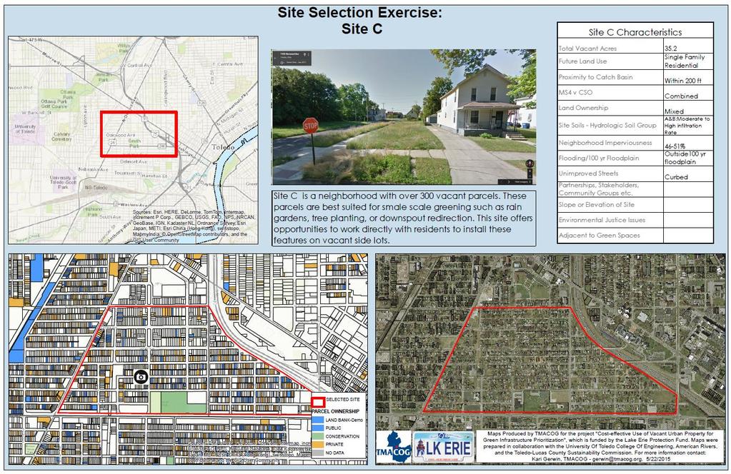
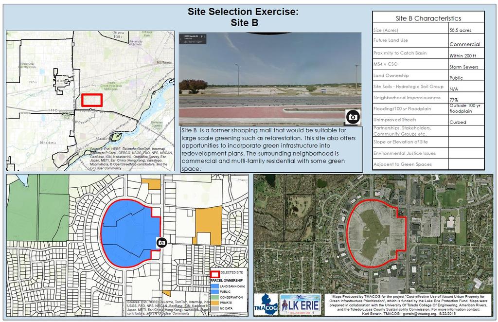
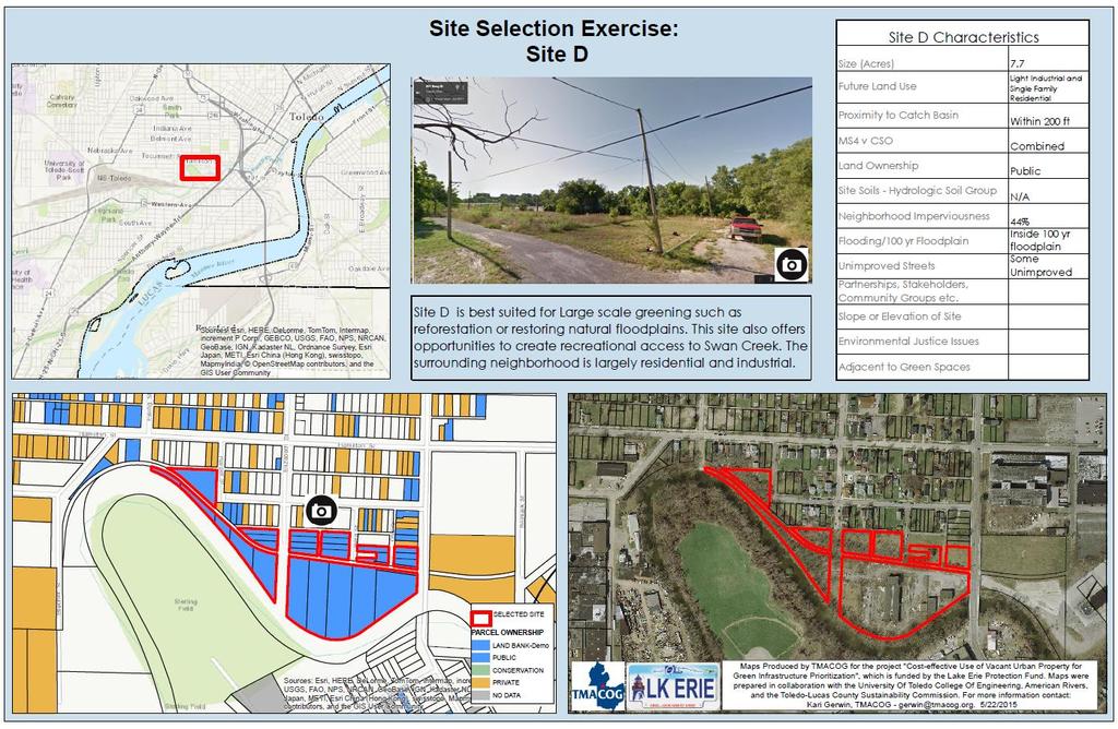
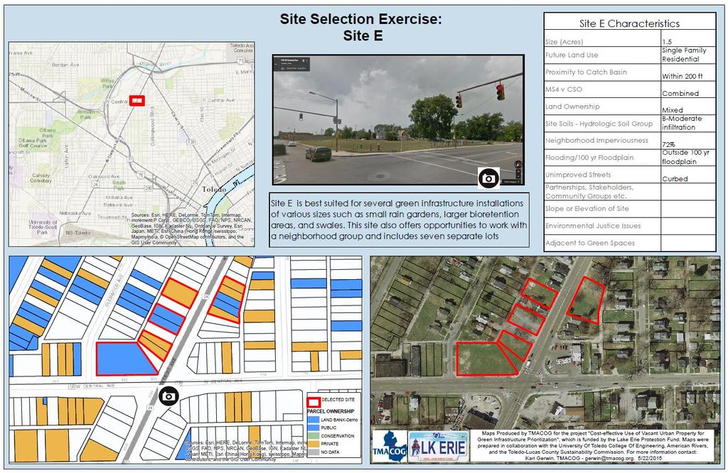
13 Highlighted vacant lots Five vacant-to-green opportunities were highlighted to showcase potential for vacant lot repurposing at various scales. These sites have been used as learning exercises at a workshop and for an ecological restoration class at Lourdes University. This exercise gave participants the opportunity to choose how best to spend green infrastructure funds based on a number of criteria. The below images can be found in full resolution in Attachment 2.
14
15

16 Process for proof-of-concept installation The additional time resulting from the project extension allowed for better partner and community coordination and ultimately a significantly more robust green infrastructure installation. $2,490 was originally budgeted for the installation, but because of a strong partnership with the Land Bank and additional grant funding from Partners for Clean Streams, over $15,000 was available for construction. TMACOG and the project team began identifying potential sites for the demonstration installation based partially upon early results of the suitability analysis, but greater emphasis was placed on the involvement of an engaged community group. Additionally, the Lucas County Land Bank was able to commit an additional $5,800 to the effort if the greening was coordinated with a property demolition and was located in a high profile location in a neighborhood that has been actively working from the grass roots on beautification and improvement efforts. Because TMACOG has worked with the Junction Avenue Neighborhood since summer 2014 on planning for green infrastructure, the planning team decided that a green infrastructure installation would provide the most benefit and the greatest potential for long-term success. TMACOG then began working closely with Junction neighborhood leaders to identify a demolition site that scored high in the analysis and was located in a high profile part of the neighborhood. The group ultimately decided on a property scheduled for demolition in spring 2015 and located across the street from an elementary school and a church. Construction was complete by the first week in November. The Land Bank has committed to providing at least three years of maintenance at the site.
17 Project outcomes One long-term benefit of this project is the creation and coordination of data that will better inform local governments and the development community on the opportunities for green infrastructure on under-utilized land. As vacant land sites are put to use in on-site green stormwater management, Lucas County's waterways and Lake Erie will see reductions in the volume of stormwater entering waterways and improvements in water quality. A benefit that this project work has already realized is increased coordination with various projects in the Toledo area. Below are a few projects that have already begun incorporating a "green infrastructure on vacant land" component. Coordination with the University of Toledo has resulted in hydrologic modeling and transferable design templates for vacant parcels in Central Toledo. Through coordination with a senior-level design class, students provided a detailed vacant lot green infrastructure design and costanalysis that was later used to acquire GLRI funding for implementation. Two bioretention facilities were among several Maumee Watershed restoration projects for which OEPA was granted GLRI funding. The proposed bioretention facilities will utilize vacant land in central Toledo Neighborhood experiencing high levels of vacancy and blight. The project will aggregate five publicly held vacant parcels to create a stormwater feature that will not only reduce stormwater discharges to a combined sewer system, but will also provide a natural amenity and learning opportunity for the community. The construction of this project is planned for Summer The vacant lots identified for this project are the foundation of the planning work completed for TMACOG s Junction Ave Urban Waters Project. Through this U.S. EPA funded project TMACOG worked with a central Toledo community to plan for green infrastructure in their community. The Land Bank has been working with the Center for Community Progress and the Trust for Public Land on an Open Space Action Plan, building on the work of TMACOG and the Junction Neighborhood to develop concrete and realistic plans to own, maintain, and pay for open space investments in the Junction neighborhood. This work will utilize the vacant lots identified through this analysis. The City of Toledo has included green infrastructure into its combined sewer overflow long-term control plan through the Toledo Waterways Initiative. For the first time, the CSO project will include green infrastructure using vacant lots identified through this project and community feedback. TMACOG presented project outcomes at a May 26, 2015 workshop hosted by the University of Toledo titled Greening the Urban Landscape to Improve Water Quality. The workshop was attended by local environmental consultants, governmental decision makers, and stormwater practitioners with the goal of encouraging the use of green infrastructure in Lucas and Wood
18 Counties. Attendees heard local case studies and participated in a site selections exercise in which they ranked the potential for greening on five vacant lots identified by this project as having high potential for one or more green infrastructure type. Details of the workshop and the project presentation can be found at Deliverables Details and links to deliverables can be found in Attachment Project webpage that property owners and local decision-makers can reference containing: Map and list of suitable sites for GI installation and lists of appropriate GI structures. The website will also include links for implementation such as design specifications, lists of local GI partners, and funding sources for future implementation. Webpage will be hosted by TMACOG. 2. GIS data of suitable sites provided to the Land Bank and the City of Toledo for GI planning purposes. - Shapefiles are included on disc 3. A flow chart model of the process used to select sites for use in on-going site prioritization 4. "Proof of concept green infrastructure installation on vacant property that will demonstrate the feasibility of using vacant land as a cost-effective stormwater treatment mechanism. 5. At least one press release (preferably covering the installation of GI) will be prepared in collaboration with TMACOG's Communications Department covering the goals of the project and applicability to water quality in the area. Lessons learned This project has provided the opportunity for more collaboration and ongoing partnerships than ever imagined by the project team. These partnerships will ultimately be instrumental in obtaining funding for greening, gaining community buy-in, and ensuring the long term success of green infrastructure practices on vacant lots across Lucas County and primarily in Toledo. Forming partnerships and gaining stakeholder support is a time-consuming process. Nevertheless, the partnership aspects of any planning or restoration project are crucial to success. While the deliverables of this project could have been completed within the original project time frame, the project extension resulted in a more robust green infrastructure practice that community members are proud to share as an educational, scientific community gathering space.
19 Resources: American Rivers. Low Impact Development Manual for the Lower Maumee and Ottawa River Watersheds City of Baltimore. Green Pattern Handbook: Using vacant land to create greener neighborhoods City of Milwaukee. Vacant Lot Handbook: A guide to reusing, reinventing and adding value to Milwaukee s city-owned vacant lots Detroit Water and Sewerage Department. Green Infrastructure Plan for the Upper Rouge Tributary Area Ohio Department of Natural Resources. Rainwater and Land Development Manual. 2006, updated 2014.
Swan Creek Urban BMP Inventory and Assessment. Jeff Grabarkiewicz, Kari Gerwin, Ann-Drea Hensley TMACOG, Lucas SWCD/Engineers, and Partners
 Swan Creek Urban BMP Inventory and Assessment Jeff Grabarkiewicz, Kari Gerwin, Ann-Drea Hensley TMACOG, Lucas SWCD/Engineers, and Partners Presentation Outline Project Background Methods Inventory Desktop
NEORSD Green Infrastructure Grant (GIG) Program Opening Remarks
 Program Opening Remarks") NEORSD Green Infrastructure Grant (GIG) Program Opening Remarks 2019 NEORSD GIG Eligibility and Technical Requirements Project must be located in the Sewer District s combined sewer area Location Applicant
NEORSD Green Infrastructure Grant (GIG) Program Opening Remarks 2019 NEORSD GIG Eligibility and Technical Requirements Project must be located in the Sewer District s combined sewer area Location Applicant
Camden SMART Initiative Stormwater Management and Resource Training
 Camden SMART Initiative Stormwater Management and Resource Training www.camdensmart.com Camden s Struggle with Stormwater 1 The City of Camden is served by a combined sewer system, which uses the same
The Benefits and Challenges Associated with Green Infrastructure Practices
 The Benefits and Challenges Associated with Green Infrastructure Practices Thomas M. Evans ASLA, LEED AP Regional Green Infrastructure Design Services Director OWEA Technical Conference, June 20, 2013
Rainscaping. Rainscaping includes rain gardens, bioswales, combinations of. A guide to local projects in St. Louis
 Rainscaping A guide to local projects in St. Louis Rain garden on South Grand Boulevard in the city of St. Louis. Rainscaping includes rain gardens, bioswales, combinations of plantings, water features,
CHAPTER 8 ISSUES, CONCERNS, CONSTRAINTS AND OPPORTUNITIES
 CHAPTER 8 ISSUES, CONCERNS, CONSTRAINTS AND OPPORTUNITIES Introduction This River Conservation Plan was developed during a time of tremendous activity and effort in planning the transformation of the Delaware
A BLUEPRINT FOR BROCKTON A CITY-WIDE COMPREHENSIVE PLAN
 A BLUEPRINT FOR BROCKTON A CITY-WIDE COMPREHENSIVE PLAN Public Meeting October 2016 1 Plan Summary and Discussion Public Meeting May 4 2017 City of Brockton Bill Carpenter, Mayor Department of Planning
Slow it, Spread it, Sink it using Green Stormwater Infrastructure
 Milly Archer Water Resources Coordinator Becky Tharp Green Infrastructure Collaborative Slow it, Spread it, Sink it using Green Stormwater Infrastructure Overview Defining LID and GSI Hydrology and impacts
No updates. NEON s work completed throughout July Notify MPRB for tree marking/stump removal
 Project Report: July December 2017 (with Jan June 2017 activities for reference) Northside Neighborhood Engagement & Opportunities in Clean Water Initiatives Goal 1: Improve water quality in Bassett Creek
Southeast Michigan Council of Governments
 Southeast Michigan Council of Governments SEMCOG Green Infrastructure Activities Regional Green Infrastructure Vision GLRI Green Streets EPA Technical Assistance MDOT Grants Green Infrastructure Vision
Third Ave CSO Integrated Green Infrastructure
 Third Ave CSO Integrated Green Infrastructure Neil Myers Williams Creek Consulting OWEA Annual Conference June 2013 For growing municipalities to be perceived as world class communities, each must move
THE JUNCTION NEIGHBORHOOD
 THE JUNCTION NEIGHBORHOOD GREENING PLAN A community vision for beautification and stormwater management PAGE INTENTIONALLY LEFT BLANK TABLE OF CONTENTS Acknowledgements iii Definitions.v Executive Summary..vii
GOING GREEN! NEWBURYPORT S PLAN FOR THE FUTURE
 GOING GREEN! NEWBURYPORT S PLAN FOR THE FUTURE Jennifer K. Lachmayr, PE, BCEE Kathryn B. Edwards, PE November 2015 Agenda Background Little River Flood Study Little River Pilot Program Vision for Implementation
Ken Kortkamp, PE San Francisco Public Utilities Commission San Francisco, CA
 Ken Kortkamp, PE San Francisco Public Utilities Commission San Francisco, CA Development Process of San Francisco s GI Typical Details SCVURPPP GI Workshop April 19, 2017 Outline How to develop GI details
MSD Project Clear s Rainscaping Program - Neighborhood Scale Rain Gardens
 MSD Project Clear s Rainscaping Program - Neighborhood Scale Rain Gardens Outline MSD Project Clear Rainscaping Program Overview Pilot Program Overview Neighborhood Scale Raingardens Siting Design Construction
Des Plaines River Watershed: Opportunity Areas North Community Cluster 1:80,000. Miles. Public Parks or Preserve. Wetland Area
 Service Layer Credits: Harris Corp, Earthstar Geographics LLC Earthstar Geographics SIO 2015 Microsoft Corporation Des Plaines River Watershed: Opportunity Areas North Community Cluster SFR: Single Family
VACANT TO VIBRANT : GREEN INFRASTRUCTURE & URBAN REVITALIZATION
 VACANT TO VIBRANT : GREEN INFRASTRUCTURE & URBAN REVITALIZATION Calumet Summit 2013: Connecting for Action Lauren Riga, Director City of Gary Department of Green Urbanism Gary Storm Water Management District
The Five Components of the McLoughlin Area Plan
 The Five Components of the McLoughlin Area Plan This documents contains the complete language of the five components of the McLoughlin Area Plan: The Vision Statement The Values The Guiding Principles
WEFTEC.06. ** City of Caldwell, Idaho
 COST-BENEFIT ANALYSIS OF URBAN STORMWATER RETROFITS AND STREAM DAYLIGHTING USING LOW IMPACT DEVELOPMENT TECHNOLOGIES Sherrill Doran*, Dennis Cannon** * CH2M HILL, 322 East Front Street, Suite 200 Boise,
The Art and Science of Stormwater Retrofitting
 The Art and Science of Stormwater Retrofitting April 9, 2008 Michael Novotney, Center for Watershed Protection Deb Caraco, Center for Watershed Protection Dan Frisbee, City of Charlottesville, Virginia
Comprehensive Plan ADOPTED APRIL 2014
 Comprehensive Plan ADOPTED APRIL 2014 8 8. Outstanding Recreational & Cultural Opportunities We are proud of our community s parks and recreation system. Our community will ensure that the legacy of our
Appendix E: Illustrative Green Infrastructure Examples
 Appendix E: Illustrative Green Infrastructure Examples Integrating LID into San Francisco s Urban Landscape Figure E. High-density Residential Figure E. Low-density Residential Figure E. Mixed Use 7 Figure
BMP Siting Tool. Step-by-Step Guide
 BMP Siting Tool Step-by-Step Guide ArcGIS 10.1 Service Pack 1 (Build 3143) Prepared by: Tetra Tech, Inc. 10306 Eaton Place, Suite 340 Fairfax, VA 22030 January 2013 Contents 1 Getting Started... 1 1.1
Funding Assistance to Stormwater Utility Fee Payers for Stormwater Solutions and Incentives. Danny Bowden City of Raleigh Stormwater Utility
 Funding Assistance to Stormwater Utility Fee Payers for Stormwater Solutions and Incentives Danny Bowden City of Raleigh Stormwater Utility Raleigh stormwater utility s cost share programs Drainage repairs
E x E C U T I v E S U M M A R y / P L A N N I N G C O N T E x T 14 //
 14 // executive summary / planning context COMMUNITY GREENING PLAN PLANNING CONTEXT Capital Region Water has entered into a partial consent decree with the United States Department of Justice to address
Public Meeting May 20, 2014
 Public Meeting May 20, 2014 Overview Study Purpose Study Area Overview Strategies Potential Opportunities Implementation and Discussion Skeo Solutions Raleigh Walkable Watershed Pilot 2 Purpose Develop
Citywide Integrated Stormwater Management Plan (ISMP) DRAFT ACTION PLAN REVIEW Public Consultation November 16 th, 2016
 DRAFT ACTION PLAN REVIEW Public Consultation November 16 th, 2016") Citywide Integrated Stormwater Management Plan (ISMP) DRAFT ACTION PLAN REVIEW Public Consultation November 16 th, 2016 1 Agenda DRAFT ACTION PLAN REVIEW Public Consultation Time 6:00 6:05 6:05 6:20 6:20
Citywide Integrated Stormwater Management Plan (ISMP) DRAFT ACTION PLAN REVIEW Public Consultation November 16 th, 2016 1 Agenda DRAFT ACTION PLAN REVIEW Public Consultation Time 6:00 6:05 6:05 6:20 6:20
Peoria has a tremendous opportunity to get sewer overflows under control and fight stormwater runoff head-on
 Peoria has a tremendous opportunity to get sewer overflows under control and fight stormwater runoff head-on The time is right to find funding solutions that address our aging infrastructure. We can enable
Green Innovation Grant Program
 Green Innovation Grant Program Southeast New York Stormwater Conference Beacon, NY October 15, 2014 What is Green Infrastructure? Green stormwater infrastructure includes a wide array of practices at multiple
Green Infrastructure. NYS Department of Environmental Conservation
 Green Infrastructure Green infrastructure is an interconnected network of natural areas and open spaces that sustains ecosystems. Benedict, M.A. and E.T. McMahon. 2006. Green Infrastructure Linking Landscapes
ARISE: The Rock Renaissance Area Redevelopment & Implementation Strategy
 2014 Professional Awards 1 ARISE: The Rock Renaissance Area Redevelopment & Implementation Strategy Janesville, WI Completed December 2014 Analysis & Planning Purpose of Project 2 The purpose of the Rock
Scorecard. WaterQuality. Appendix B USEPA WATER QUALITY SCORECARD APPENDIX B
 Appendix B USEPA WATER QUALITY SCORECARD EPA 231B09001 October 2009 http://www.epa.gov WaterQuality Scorecard Incorporating Green Infrastructure Practices at the Municipal, Neighborhood, and Site Scales
Outflow to Saw Mill Run
 Dormont Stormwater Fee Frequently Asked Questions What is stormwater, and why is it a problem in Dormont? Stormwater is runoff from rain or snow that falls and flows to Little Saw Mill Run or McNeilly
CITY OF HOLLY SPRINGS STORMWATER UTILITY FREQUENTLY ASKED QUESTIONS
 CITY OF HOLLY SPRINGS STORMWATER UTILITY FREQUENTLY ASKED QUESTIONS GENERAL What is a Stormwater Utility and why is it needed in Holly Springs? A Stormwater Utility is an entity responsible for the daily
Sustainable Stormwater Management through Green Infrastructure. Jersey City Public School #5
 Green Infrastructure Site Evaluation Friday, October 25 th, 2013 Sustainable Stormwater Management through Green Infrastructure Jersey City Public School #5 FORMAT: (15 minutes) An Introduction to Stormwater
Mary Norwood. Mayoral Forum on Greenspace Responses
 1. What do you believe is the single most pressing issue impacting Atlanta s urban forest and greenspace, and how would you solve that issue? Preserving and Protecting Atlanta s forest cover Lungs of Atlanta
City of Petersburg, VA Stormwater Utility Frequently Asked Questions
 Q. What is stormwater runoff? A. Stormwater runoff is the water that flows off roofs, driveways, parking lots, streets and other hard surfaces during rain storms. Stormwater runoff is also the rain that
Case Study: City of San Mateo
 Published on GreenPlan-IT (http://greenplanit.sfei.org) Home > Archived Materials > GreenPlan-IT Toolkit Demonstration Report > Chapter 2. Case Study: City of San Mateo Case Study: City of San Mateo Chapter
INTRODUCING THE BALTIMORE CITY GREEN NETWORK VISION PLAN
 INTRODUCING THE BALTIMORE CITY GREEN NETWORK VISION PLAN GOALS OF THE GREEN NETWORK PLAN Protect and enhance the unique ecological resources of our city Support economic growth and sustainable redevelopment
A Blueprint for Reuse of Distressed Parcels
 Barthman Parsons Integrated Solutions A Blueprint for Reuse of Distressed Parcels Steven D. Thompson, P.E. (AECOM) C. Timothy Fallara, P.E. (City of Columbus, Sewerage & Drainage) Presentation Agenda Introduction
North Fair Oaks Community Plan Summary and Information
 North Fair Oaks Community Plan Summary and Information WHAT IS THE NORTH FAIR OAKS COMMUNITY PLAN? The North Fair Oaks Community Plan is part of the San Mateo County General Plan, and establishes policies
Green Roofs and Stormwater Management Virginia Stovin
 Green Roofs and Stormwater Management Virginia Stovin Department of Civil and Structural Engineering Pennine Water Group University of Sheffield Outline Urban stormwater management Conventional solutions,
Work Plan. Introduction:
 Work Plan Introduction: The original construction of Santa Rosa s City Hall was done in an era when storm water was collected and conveyed as quickly as possible, where water intensive lawns were the norm,
Soak it up! Policies and tools for community-wide implementation of green stormwater infrastructure. Alix Taylor, Green Communities Canada
 Soak it up! Policies and tools for community-wide implementation of green stormwater infrastructure Alix Taylor, Green Communities Canada Green Communities Canada RAIN Program Soak it Up! Toolkit Stormwater
Low Impact Development in Coastal South Carolina: A Planning and Design Guide
 Low Impact Development in Coastal South Carolina: A Planning and Design Guide ACE Basin & North Inlet-Winyah Bay National Estuarine Research Reserves Network of 28 Reserves NOAA Program Research, Stewardship,
Regional Stormwater Management Program
 Business Risk Exposure (BRE) Score BTU Community Cost-Share Program (CCSP) Cistern Condition Rating of RSS Asset Criticality of a RSS asset Detention Basin Education Credit Equivalent Residential Unit
Pittsfield Action Plan (West Branch of the Housatonic River)
") An initiative of the Massachusetts Executive Office of Energy and Environmental Affairs in partnership with the City of Pittsfield Pittsfield Action Plan (West Branch of the Housatonic River) The spring
An initiative of the Massachusetts Executive Office of Energy and Environmental Affairs in partnership with the City of Pittsfield Pittsfield Action Plan (West Branch of the Housatonic River) The spring
What is stormwater runoff? Why is it a problem? Available Financial Incentives for Stormwater BMP s Downspout Disconnection - up to $20
 What is stormwater runoff? Stormwater is any form of natural precipitation (including ice and snow melt) that flows across undeveloped or developed land. In a natural setting, a majority of the water seeps
Deer Creek Watershed Stakeholders Committee
 Deer Creek Watershed Stakeholders Committee Stakeholder Partners East West Gateway Council of Governments Great Rivers Greenway District Local Municipalities Metropolitan St. Louis Sewer District Missouri
Structural Measures at a Glance
 Structural Measures at a Glance 1 Combined Approaches (Notional Graphic) www.nyc.gov Sea Level Change 2 Sandy s Rebuild By Design Effort: Hoboken www.rebuildbydesign.org 3 Courtesy of the Office of Metropolitan
Green Infrastructure and Low-Impact Development Technologies
 Green Infrastructure and Low-Impact Development Technologies The guiding principles of these technologies is to manage stormwater at their sources using natural means, and establish conditions so that
Stormwater Fee Credit Manual
 NORTHEAST OHIO REGIONAL SEWER DISTRICT Stormwater Fee Credit Manual June 30, 2010 NEORSD Stormwater Fee Credit Manual June 30, 2010 Table of Contents I. Introduction 1 What is a Stormwater Fee? 2 What
FOUR MILE RUN VALLEY WORKING GROUP AND CHARGE
 FOUR MILE RUN VALLEY WORKING GROUP AND CHARGE Adopted April 16, 2016 Amended July 19, 2016 Overview of Integrated Effort The overall goal of the Four Mile Run Valley (4MRV) initiative is to develop a comprehensive
LOW IMPACT DEVELOPMENT GUIDANCE MANUAL AND LID WORKING GROUP ACTIVITIES. Powerpoint Templates. MS4 Statewide Stormwater Summit June 18, 2013
 LOW IMPACT DEVELOPMENT GUIDANCE MANUAL AND LID WORKING GROUP ACTIVITIES MS4 Statewide Stormwater Summit June 18, 2013 Powerpoint Templates Evan Canfield, Ph.D, P.E. Pima County Regional Flood Control Outline
BE WATER WISE. Managing Your Onlot Stormwater. Sept. 23, 2006 Watershed Weekend
 BE WATER WISE Managing Your Onlot Stormwater Sept. 23, 2006 Watershed Weekend 2006 1 All water resources are interrelated through the Hydrologic Cycle Sept. 23, 2006 Watershed Weekend 2006 2 What is Storm
Physical Approaches to Flood Mitigation
 Physical Approaches to Flood Mitigation ational Academy of Sciences /19/2017 Chicago Area Before Development Widespread Flooding Waterways and Marshes Absorbent Ground Early settlers came to this location
Swatara Township Stormwater Program. 1. There are no storm sewers on or near my property. Why should I pay a fee?
 1. There are no storm sewers on or near my property. Why should I pay a fee? All properties produce stormwater runoff that must be managed by the Township. Even if your property has never flooded and there
Project Funder: Seattle Department of Transportation. Project Location: Winona Ave. N. Seattle. Project BMP(s): Roadside bioretention
: Roadside bioretention") Seattle Department of Transportation Winona Ave. N. Seattle Roadside bioretention Initiated by adjacent residents as an intersection repair project. Improved pedestrian crossing at dangerously wide oblique
Seattle Department of Transportation Winona Ave. N. Seattle Roadside bioretention Initiated by adjacent residents as an intersection repair project. Improved pedestrian crossing at dangerously wide oblique
Smart Growth for Dallas
 Smart Growth for Dallas Using data and GIS to improve the social, economic, and environmental resilience of Dallas Dallas Park and Recreation Board November 1, 2018 About Our Partners The Trust for Public
Green Infrastructure Policies and Ordinances
 Green Infrastructure Policies and Ordinances October 23, 2013 By Karen Firehock, Green Infrastructure Center 2013 Georgia Urban Forest Council s 23 rd Annual Conference The mission of the nonprofit Green
Lake and Stream Restoration Project
 Pre-project Fact Sheet May 2012 Toledo Botanical Garden (TBG) is a 60 acre public garden visited by more than 120,000 people annually. It is located in Toledo, Ohio in the Ottawa River watershed within
Detroit Stormwater Rules and Drainage Fee Updates
 2016 Regional Stormwater Summit Detroit Stormwater Rules and Drainage Fee Updates Dan Christian, PE, D.WRE Tetra Tech INTRODUCTION 10/7/2016 DRAFT - For Discussion Purposes Only 2 Historically No formal
Chapter 9 Community Facilities & Services Plan. Introduction. Cooperative Efforts. Monitoring of Needs
 Chapter 9 Community Facilities & Services Plan Introduction The location of key community facilities such as water, sewer, schools, parks, and roads is important to the provision of the necessary services
2008 Annual report of the UT Presidents Commission on the River
 The University of Toledo The University of Toledo Digital Repository President's Commission on the River Office of the President 2008 Annual report of the UT Presidents Commission on the River Patrick
NYC Green Infrastructure Program
 NYC Green Infrastructure Program 2013 Green Infrastructure Annual Report Kevin Dahms, Assistant Director, NYC DEP Office of Green Infrastructure Pre-Release Briefing for DEC ENGS 44 Sustainable Design
From and
 GREEN INFRASTRUCTURE IN PROVIDENCE, RI The Box Office From http://web.uri.edu/riss/the-box-office/ and http://www.morrisbeacon.com/media/portfolioprojects/implementation/box-office/box%20office.pdf: At
Regional Open Space Conservation Plan. Regional Staff Committee January 18, 2018
 Regional Open Space Conservation Plan Regional Staff Committee January 18, 2018 Schedule We are here Task 1 - Stakeholder Input & Work Plan Dev. v z 2016 2017 2018 Oct Nov Dec Jan Feb Mar Apr May Jun Jul
Presenting a Vision for Thread Lake
 Presenting a Vision for Thread Lake FEBRUARY 20, 2014 SPECIAL THANKS TO: International Academy of Flint Flint River Watershed Coalition South Saginaw Business and Resident Association South Side Neighborhood
Green Infrastructure: Implementation at the Community Level
 Green Infrastructure: Implementation at the Community Level Debbie Mans NY/NJ Baykeeper Sandra Meola NY/NJ Baykeeper Pamela Daniels United Vailsburg Services Organization NY/NJ Baykeeper NY/NJ Baykeeper's
Sustainable Storm Water Management
 Incorporating Water Management into the Community Planning Process August 16, 2012 Sustainable Storm Water Management Samantha Brown Environmental Engineer SD1 SD1 s Service Area CVG Airport SD1 Service
2011 ASLA Design Awards. Westside Creeks Restoration Plan Merit Award AECOM, Fort Collins. Planning & Urban Design
 2011 ASLA Design Awards Westside Creeks Restoration Plan Merit Award AECOM, Fort Collins Planning & Urban Design Project Fact Sheet Category of Entry: Rotating Specialty Award: 2011 2011 ASLA Colorado
Green Infrastructure Modeling in Cincinnati Ohio. Small Scale Green Infrastructure Design Using Computer Modeling
 Green Infrastructure Modeling in Cincinnati Ohio Small Scale Green Infrastructure Design Using Computer Modeling Presenters Jason Abbott is a Design Engineer with over 17 years of experience. Jason is
EXISTING PLANS Harriet Festing Center for Neighborhood Technology Midlothian Community Meeting March 12, 2015
 EXISTING PLANS Harriet Festing Center for Neighborhood Technology Midlothian Community Meeting March 12, 2015 BENEFITS Bring economic, community + environmental benefits Enhance property values Use
Green Infrastructure Recommendations For Parks and Public Spaces
 Green Infrastructure Recommendations For Parks and Public Spaces Issued by the Jersey Water Works Green Infrastructure Committee And Prepared by Meliora Design This document recommends ways to integrate
G. RECREATION AND OPEN SPACE ELEMENT. The following summarizes the Recreation and Open Space Element:
 G. RECREATION AND OPEN SPACE ELEMENT The purpose of the Element is to provide the framework and direction for a comprehensive system of public and private sites for recreation, including, but not limited
BEST LOCAL LAND USE PRACTICES
 Ohio Balanced Growth Program BEST LOCAL LAND USE PRACTICES BIOSWALES AND BIORETENTION IN THE RIGHT-OF-WAY The Ohio Balanced Growth Program, and its Best Local Land Use Practices component, continue to
Scope of Services. River Oaks Boulevard (SH 183) Corridor Master Plan
 Corridor Master Plan") Scope of Services River Oaks Boulevard (SH 183) Corridor Master Plan PROJECT AREA The project area consists of the River Oaks Boulevard (SH 183) corridor bounded by SH 199 at the northern end and the Trinity
Scope of Services River Oaks Boulevard (SH 183) Corridor Master Plan PROJECT AREA The project area consists of the River Oaks Boulevard (SH 183) corridor bounded by SH 199 at the northern end and the Trinity
Summary of Action Strategies
 Strategic Action Plan 6 Summary of Action Strategies Action Strategy Categories: 1. Organization and Management 2. Implementation 3. Marketing and Promotion This chapter summarizes all of the action strategies
Concord Community Reuse Project Goals and Guiding Principles. Overarching Goals (OG)
") Concord Community Reuse Project Goals and Guiding Principles Overarching Goals (OG) No priority is implied by the order of presentation of the goals and guiding principles. Overarching goals for the Concord
Concord Community Reuse Project Goals and Guiding Principles Overarching Goals (OG) No priority is implied by the order of presentation of the goals and guiding principles. Overarching goals for the Concord
RECREATION AND OPEN SPACE ELEMENT GOALS, OBJECTIVES, AND POLICIES
 RECREATION AND OPEN SPACE ELEMENT GOALS, OBJECTIVES, AND POLICIES Goal 7 To provide park facilities, recreation programs, and open space resources that are safe, adequate, and accessible to all City residents,
Understanding Stormwater Drainage Maintenance
 WARREN COUNTY STORMWATER DISTRICT Understanding Stormwater Drainage Maintenance Home Owner s Association Guide Introduction Our goal is to help property owners and Home Owner s Associations (HOA) understand
Western Pennsylvania Conservancy Clairton & Harrison Community Greening Assessment Projects Request for Proposals July 2018
 Western Pennsylvania Conservancy Clairton & Harrison Community Greening Assessment Projects Request for Proposals July 2018 Proposal Information The Western Pennsylvania Conservancy (WPC) is seeking proposals
Photo by Carlton Ward Jr. Executive Summary
 Photo by Carlton Ward Jr. Executive Summary The Cooperative Conservation Blueprint (Blueprint) is a multi-partner strategic conservation process developed by the Florida Fish and Wildlife Commission (FWC)
Green Streets. Sustainable Stormwater Solutions for Greener Communities and a Cleaner Bay
 Green Streets Sustainable Stormwater Solutions for Greener Communities and a Cleaner Bay As the Bay Area continues to grow through development of roads, revitalization of neighborhoods, and construction
Two Sides of the Green Infrastructure Coin. Jaren Hiller, PE, LEED AP Nathan Guequierre
 Two Sides of the Green Infrastructure Coin Jaren Hiller, PE, LEED AP Nathan Guequierre May 5, 2016 Background Citywide Stormwater Planning WinSLAMM Analysis No Control Existing Conditions Proposed Conditions
CLEAN WATER ADVOCATE Winter Rudolph S. Chow
 50 Rudolph S. Chow Winter 2019 51 CLEAN WATER ADVOCATE To Help Meet Clean Water Goals, Baltimore s Innovative Community Events Build Goodwill As Much As They Promote Green Infrastructure Y ou may have
systems is available on the Colorado Wetland Information Center (CWIC) website.
 website.") Colorado Natural Heritage Program Wetland Program Plan -- Dec 2015 Status Update and Addendum -- The Colorado Natural Heritage Program (CNHP) developed a Wetland Program Plan (WPP) in 2010 for the planning
Colorado Natural Heritage Program Wetland Program Plan -- Dec 2015 Status Update and Addendum -- The Colorado Natural Heritage Program (CNHP) developed a Wetland Program Plan (WPP) in 2010 for the planning
Implementing sustainable water strategy through development industry engagement
 Implementing sustainable water strategy through development industry engagement Ian Director, Organica Engineering, Melbourne, Australia E-mail: iadams@organicaeng.com.au Edward Cotter Sustainability Leader,
Green Infrastructure & Low Impact Development
 Green Infrastructure & Low Impact Development CITY OF COVINGTON STORMWATER MANAGEMENT WHAT IS GREEN INFRASTRUCTURE? Green infrastructure uses vegetation, soils and natural processes to manage water and
Stormwater Utility Literature Review
 Stormwater Utility Literature Review February 2017 Overview Formation of stormwater utilities and collection of stormwater fees is one mechanism that communities can use to maintain, replace, and upgrade
PUBLIC ENGAGEMENT & SIX THEMES OF THE PLAN
 Connecting the heart of Eagle to the soul of the river - Kathy Chandler-Henry, Commissioner Eagle County CHAPTER 1 PUBLIC ENGAGEMENT & SIX THEMES OF THE PLAN town of eagle - river corridor plan 1 PUBLIC
FOUR MILE RUN VALLEY WORKING GROUP AND CHARGE Adopted April 16, 2016 Amended July 19, 2016
 FOUR MILE RUN VALLEY WORKING GROUP AND CHARGE Adopted April 16, 2016 Amended July 19, 2016 Working Group Charge The Working Group is charged by the County Board to collaborate with staff to provide commission,
COMMUNITY SUSTAINABILITY AND ENVIRONMENTAL MASTER PLAN IMPLEMENTATION UPDATE
 Attachment 1 COMMUNITY SUSTAINABILITY AND ENVIRONMENTAL MASTER PLAN IMPLEMENTATION UPDATE Priorities and Key Initiatives Committee May 2013 Page E-1 How we grow Goal 2: To ensure sustainable development
INTRODUCTION TO GREEN INFRASTRUCTURE HOW WE CAN PROTECT OUR COMMUNITIES AND OUR WATERS Maywood Public Library Bergen County, New Jersey
 INTRODUCTION TO GREEN INFRASTRUCTURE HOW WE CAN PROTECT OUR COMMUNITIES AND OUR WATERS Maywood Public Library Bergen County, New Jersey Jeremiah D. Bergstrom, LLA, ASLA Rutgers Cooperative Extension Water
Post - Construction Hydromodification Development Requirements
 Condensed Version - Interim Low Impact Development / Hydromodification Guidelines, City of Lompoc 1 Post - Construction Hydromodification Development Requirements I. PURPOSE A. The purpose of these requirements
2.1 Principles & Objectives
 Designing With The Landform 2.1 Principles & Objectives Land planning which integrates the natural features of a site (i.e., designing with the landform ) into the site design is a major component of the
3. VISION AND GOALS. Vision Statement. Goals, Objectives and Policies
 Vision Statement Queen Creek s interconnected network of parks, trails, open spaces and recreation opportunities provide safe and diverse activities and programs that sustain its unique, small town, equestrian
FLEET AVENUE GREEN STREET USES VACANT LOT FOR CSO REDUCTION. Thomas M. Evans, AECOM Cleveland, Ohio
 FLEET AVENUE GREEN STREET USES VACANT LOT FOR CSO REDUCTION Thomas M. Evans, AECOM Cleveland, Ohio INTRODUCTION As part of the Northeast Ohio Regional Sewer District s (Sewer District) Green Infrastructure
CHECKLIST AND BENCHMARKS
 IMAX Corporation, Mississauga Greening CORPORATE Grounds CHECKLIST AND BENCHMARKS Participant Information Name Address Program Start Date Date of Last Assessment Level at Last Assessment Teck Metals Ltd,
Sustainable Keuka Lake
 Sustainable Keuka Lake Steve Butchko, Town of Wayne Supervisor Chelsea Robertson, Senior Planner STC Kemberli Sargent, Planner STC www.sustainablekeuka.net This presentation was prepared for the New York