Final Report March, 2008
|
|
|
- Elijah Ray
- 6 years ago
- Views:
Transcription


1 Final Report March, 2008 Charlottesville Stormwater Stewardship on Public Lands
2 Acknowledgments The project team from the Center for Watershed Protection, Inc. (CWP), would like to acknowledge the substantial and meaningful contributions to this project from Kristel Riddervold and Dan Frisbee from the City of Charlottesville s Environmental Administration Division of the Department of Public Works. In addition, CWP would like to thank the other professionals from the Charlottesville City Schools and the following City of Charlottesville departments who contributed their talents and time: Department of Public Works Department of Parks & Recreation Department of Neighborhood Development Services Funding for this project came from the City of Charlottesville, Charlottesville City Schools, and the Small Watershed Grants Program. The Small Watershed Grants Program is administered by the National Fish and Wildlife Foundation, in cooperation with the U.S. Environmental Protection Agency, Chesapeake Bay Program. The views and conclusions contained in this document are those of the authors and should not be interpreted as representing the opinions or policies of the U.S. Government or the National Fish and Wildlife Foundation. Mention of trade names or commercial products does not constitute their endorsement by the U.S. Government or the National Fish and Wildlife Foundation. The CWP project team consisted of the following individuals: David Hirschman, Project Manager Michael Novotney Lisa Fraley-McNeal Jennifer Zielinski Tom Schueler Kathy Proebstle In addition, the following contractors made significant contributions to the design phase of the project: Eliot Fendig and Rick Artiga, Bent Tree Design Benjamin Sojka, Rainwater Management Solutions
3 Table of Contents Page # 1. Introduction Project Background Overall Process Retrofit Scoping & Initial Ranking Collect Available GIS Data Delineate Subwatersheds Delineate Impervious Cover on Each Public Land Parcel Analyze Subwatershed Context Analyze Treatment Area Available for On-Site & Off-Site Runoff Identify Relationships to Trails, Flood Plains, Stream Buffers, Water Quality Management Study Screen Public Lands for Retrofit Feasibility Work with City Staff to Identify Initial Performance Goals Review of Innovative BMPs Retrofit Inventory & Sketch Plans Process for Retrofit Inventory Results of Retrofit Inventory Retrofit Evaluation & Ranking Objectives of Evaluation & Ranking Identification of Screening Factors & Weights Deriving Data for Pollutant Load Reductions & Costs Scoring Ranking of Projects Project Design Recommendations for Retrofit Implementation & Delivery...41 References...46 Appendix A: Charlottesville Retrofit Field Guide...A.1 Appendix B: Charlottesville Retrofit GIS Attribute Table...B.1 Appendix C: Retrofit Reconnaissance Investigation Form...C.1 Appendix D: Retrofit Scoring & Ranking Table...D.1 Appendix E: Retrofit Projects by Site...E.1 Appendix F: Design Information... F.1 Center for Watershed Protection, Page i
4 Center for Watershed Protection, Page ii
5 List of Figures Page # Figure 1. Inspired Stormwater... 3 Figure 2. Typical Retrofitting Activities as Part of Charlottesville Public Lands Stewardship Figure 3. Examples of Highly Ranked Sites...36 Figure 4. Ways to Maximize Retrofit Delivery throughout the Subwatershed...42 Center for Watershed Protection, Page iii
6 Center for Watershed Protection, Page iv
7 List of Tables Page # Table 1. GIS Data Layers used in the Initial Ranking Process...5 Table 2. CWP Delineated Sewersheds...6 Table 3. Public Lands Impervious Cover...8 Table 4. Subwatershed Context...10 Table 5. Minimum Treatment Area for On-Site and Off-Site Runoff...12 Table 6. Public Lands Intersection with Flood Plain, Stream Buffer, Trails, and Water Quality Study Recommendations...14 Table 7. Retrofit Feasibility...15 Table 8. Proposed Performance Goals...16 Table 9. The Six Most Common Storage Retrofit Locations in a Subwatershed...17 Table 10. The Seven Most Common On-Site Retrofit Locations in a Subwatershed...19 Table 11. Projects Identified as Part of the Retrofit Inventory...24 Table 12. Implementation Strategies for the Various Categories of Projects...27 Table 13. Scoring Criteria used for Ranking...28 Table 14. Pollutant Load Calculation Parameters used in the Simple Method...29 Table 15. Unit Costs of Various BMPs...30 Table 16. Pollutant Removal Efficiency of Various BMPs...31 Table 17. Pollutant Load and Cost Data Example from CHS...32 Table 18. Scoring Form Example from Buford School...33 Table 19. Individual Project Ranking...34 Table 20. Projects Selected for Design Work...38 Center for Watershed Protection, Page v
8 Center for Watershed Protection, Page vi
9 Charlottesville Stormwater Stewardship on Public Lands FINAL REPORT March 24, Introduction 1.1. Project Background Communities across the country are increasingly viewing stormwater management as an opportunity to improve the environment, create desirable public spaces, engage the community in environmental stewardship, and remedy historic errors, when development took place with inadequate stormwater controls. This view of stormwater management represents a departure from the past, when stormwater was considered as an engineering detail, and facilities tended to unsightly and deliberately removed from public view or any aspect of public engagement. It is refreshing these days to see projects across the country where stormwater is harvested and reused (in an age of increasing water scarcity), practices are landscaped to invite the public in for exploration and learning, and stormwater is integrated with trails, public spaces, and the architecture of green buildings. Figure 1 shows several examples of inspired stormwater from around the country and internationally We are also increasingly aware that the way we manage stormwater reflects on other aspects of environmental stewardship. For instance, if we can harvest and reuse runoff that would otherwise flow downstream as a waste product, then we are not only protecting our downstream resources, but reducing our demand on potable water supplies for non-potable needs (an issue of great import given the Charlottesville area s recent drought conditions and search to fund future water supply needs). If we make better use of open spaces for stormwater attenuation, then we decrease reliance on costly engineering solutions as well as time and money spent maintaining and mowing turf. The City of Charlottesville has acted to promote progressive stormwater management. In addition to other efforts, the City secured a grant from the National Fish & Wildlife Foundation to fund a project entitled, Stormwater Stewardship on Public Lands. The intent of this project is to conduct a comprehensive stormwater management and retrofitting feasibility study for City-owned properties, with a focus on school and park sites. The City is interested in innovative water quality techniques that also have benefits for public education and outreach. Retrofitting refers to the practice of installing stormwater management practices in places where development has already occurred with no or ineffective stormwater treatment. Retrofitting is the principal method to restore urban watersheds where impacts already exist. The City contracted with the Center for Watershed Protection, Inc. ( the Center ) after a competitive selection process. The Center partnered with Bent Tree Design and Rainwater Management Solutions (RMS) for the design portion of the study. The former is an engineering and landscape architecture firm. The latter firm specializes in the design and installation of rainwater harvesting systems. The Center also made extensive Center for Watershed Protection, Page 1
10 use of its recently released national publication on stormwater retrofitting, Urban Stormwater Retrofit Practices (Schueler et al., 2007). After an initial scoping and ranking process, 24 out of a total of 33 school and park sites were identified for field evaluation based on their subwatershed context and the performance goals identified by City staff and the Center. Fieldwork was conducted from July 9-11, 2007 to identify potential stormwater retrofits and stewardship practices. Retrofits were then evaluated and ranked by a system of screening factors and weights based on the initial performance goals. The ranked list of projects was discussed with City staff and the strongest candidates for design work were selected. Other projects, such as pollution prevention and landscape stewardship, were also identified so that they can be incorporated into existing operation and maintenance activities. Eight projects were selected for more detailed design as the necessary first step in implementation. The Center, Bent Tree Design, and RMS developed design drawings and specifications for the selected projects. Some of the designs were to a concept level, and will require some final engineering details prior to construction. Other designs are more detailed and are ready for construction, pending detailed planting plans. The documents will also help the City secure additional grant and other funding to help pay for construction. Center for Watershed Protection, Page 2


 Drop Inlet Art in Sao")

11 Stormwater Art in Seattle, Washington Rooftop Collection & Scuppers at Sanitation District of Northern Kentucky Street Edge Alternatives Bioswale Retrofit in Seattle, Washington Urban Biofilter Streetscapes in Portland, Oregon? Rain garden in Greenleaf Park Interlocking Concrete Pavers (source: icpi.com) Drop Inlet Art in Sao Paolo, Brazil Inspired Stormwater Japanese Manhole Cover Figure 1. Center for Watershed Protection, Page 3
12 1.2. Overall Process The project included six overall tasks: Task 1 Retrofit Scoping & Initial Ranking The Center performed a desktop analysis of available data to develop an initial ranking of retrofit potential for City-owned property. A facilitated meeting was held with key City staff to identify performance goals and identify the most critical issues from a stormwater perspective. Task 2 Review of Innovative BMPs The Center provided the City with its recently released manual, Urban Stormwater Retrofit Practices, that contains extensive information on identifying and evaluating potential retrofit locations within a subwatershed, as well as profile sheets on individual retrofit designs that include pollutant removal estimates, and guidance on construction, maintenance, and cost. This manual provides a comprehensive review of innovative practices that was utilized throughout this study. Task 3 Retrofit Inventory & Sketch Designs Fieldwork was conducted from July 9-11, 2007, by the Center and City staff and focused on 24 sites identified in the Scoping & Initial Ranking. The latest Retrofit Reconnaissance Investigation (RRI) form and methods from Urban Stormwater Retrofit Practices were used. Task 4 Retrofit Evaluation & Ranking Retrofit projects were evaluated based on pollutant load reductions, cost-effectiveness, and other screening factors derived from the initial performance goals. Other projects, such as pollution prevention and landscape stewardship, also reduce pollutant loads, but are more difficult to quantify and can more easily be built into existing operation and maintenance activities. The ranked projects were discussed at a meeting in October 2007 to determine the strongest candidates for design work. Task 5 Project Preliminary Design The Center and City staff selected six specific and two conceptual projects based on Retrofit Evaluation & Ranking. The services of Bent Tree Design, a local engineering and landscape architecture firm, were used to assist with design drawings for four projects. Rainwater Management Solutions was contracted to provide specifications for two rainwater harvesting projects. In addition, the Center developed conceptual designs and specifications for two other types of stormwater treatment that may be applied to future projects. Task 6 Final Report, Presentations & Public Outreach The Center will present the Draft Report, as well as the Final Report to the review committee. The Center will also recommend specific public outreach efforts to promote public understanding of and interest in projects. Center for Watershed Protection, Page 4
13 2. Retrofit Scoping & Initial Ranking This task involved a desktop analysis of available data sets to develop an initial ranking of retrofit potential for City-owned property. This task was essential in focusing the subsequent field work on the best opportunities to make meaningful improvements on the public lands themselves and in the subwatersheds within which they are situated. The task involved the following steps: Collect available GIS data Delineate subwatersheds for public lands analysis Delineate impervious cover on each public land parcel Analyze subwatershed context for each public land parcel Analyze treatment area available for on-site and off-site runoff Identify relationship of public lands parcels to trails, flood plains, and stream buffers Screen public lands for retrofit feasibility Work with City staff to identify initial performance goals 2.1. Collect Available GIS Data Table 1 shows the GIS data layers obtained from the City and utilized during the initial ranking process. Table 1. GIS Data Layers used in the Initial Ranking Process Data Type Layers Hydrology Creeks and Rivers Stream Buffer Areas Streams in Pipes Streams in Culverts Wetlands 100 Year Floodplain Stormwater Stormwater Culverts Stormwater Pipes Storm Structures Storm Sewersheds Topography 2 Foot Contours 5 Foot Contours Infrastructure City Limits Parcels Structures Rivanna Trails Foundation Trails City Trails Aerial Photos 2006 Orthophotos Center for Watershed Protection, Page 5
14 2.2. Delineate Subwatersheds The 2007 storm sewershed GIS layer was provided by the City. The term sewershed is used to refer to a drainage area, as modified by the built system of storm pipes, ditches, and other conveyances. In some cases, sewershed boundaries are altered from natural topographic drainage area divides. In order to create meaningful subwatersheds for management purposes, several of the existing sewersheds were combined. In particular, very small sewersheds were combined where all of the drainage flowed to a common stream or outlet point. Table 2 provides the updated list of sewersheds and their areas. Where original sewersheds were combined, the original sewershed ID numbers are noted in parentheses. Table 2. CWP Delineated Sewersheds Name Area (ac) Meadow Creek 854 Greenbrier 288 Rutledge 141 Seminole 124 North Berkshire 209 Copley Hill/UVA Headwaters 488 (combined 7, 10) Meadowbrook Road 158 Oxford Meadowbrook Creek 388 Schenks Branch/McIntire Culvert (combined ,16,17) St Charles Creek 251 Rivanna 529 Old Ivy Road/Lewis Mtn 401 (combined 14, 15) Fontaine 167 Valley Road/Rockcreek 666 (combined 20, 30, 31, 32, 33) Frys Springs 62 Sunset 53 Old Lynchburg/McElroy 89 Azalea 76 Jackson Via 106 Green Valley/Rockcreek 292 Meade Ave Creek 280 Moores Creek 456 Pollocks Branch 483 Barracks Road/Meadow Creek (combined 6, 37) 482 Fontaine Ave/Stadium Rd Delineate Impervious Cover on Each Public Land Parcel Impervious cover is defined as the sum of roads, parking lots, sidewalks, rooftops, and other impermeable surfaces of the urban landscape. It is a very useful indicator with which to measure the impacts of land development on aquatic systems. Increased Center for Watershed Protection, Page 6
15 impervious cover leads to increases in the peak discharge, velocity, and volume of stormwater runoff. Urban pollutant loads are also directly related to imperviousness. During storms, accumulated pollutants are quickly washed off and rapidly delivered to aquatic systems (Schueler, 2000). For the Charlottesville public lands, total impervious cover was not available as an offthe-shelf layer. To develop this layer, the Center combined the existing City structures layer, which accounts for rooftop impervious cover, with Center-delineated impervious surfaces, including roads, parking lots, and basketball and tennis courts for each public land parcel. Table 3 shows the total impervious cover for each of the public land parcels. Center for Watershed Protection, Page 7
16 Parcel ID Name Table 3. Public Lands Impervious Cover Total Parcel Area (ac) Total Parcel Impervious Area (ac) Total Impervious Cover (%) 33 Azalea Park % 143 Bailey Park % 114 Belmont Park % 7365 Buford School % 4893 Burnley-Moran School % 1231 CHS % 9432/ 9539 Clark School % 31 Fifeville Park % 8 Forest Hills Park % 1 Greenbrier Park % 216 Greenbrier School % 3 Greenleaf Park % 29 Jackson Park % Jackson-Via School % 9208 Johnson School % 115 Jordan Park % 28 Lee Park % 27 McGuffey Park % 111 McIntire Park - West % 59 McIntire Park - East % 142 McIntire Skate Park / Schenk s Greenway 3.97* 1.81* 46%* 7 Meade Park % 2 Meadowcreek Park % 4 Northeast Park % 110 Pen Park % 25 Quarry Park % 6 Riverview Park % 26 Rives Park % 144 Starr Hill % 113 Tonsler Park % 3922 Venable School % 1121 Walker School % 112 Washington Park % *Data only refers to McIntire Skate Park Center for Watershed Protection, Page 8
17 2.4. Analyze Subwatershed Context Each public land parcel was analyzed within the context of its subwatershed. The drainage area to each public lands parcel was delineated based on sewersheds (drainage areas, as modified by the storm sewer system), topography, and the existing drainage network. The following categories were created for subwatershed context: Contributing Properties are generally located at or close to the upper reaches of a subwatershed. They contribute runoff to the downstream system, but receive little from off-site areas. As such, most of the retrofit potential is to treat runoff from on-site. Receiving Properties are located near the bottom or downstream end of a subwatershed. In contrast to contributing properties, they may receive quite a bit of runoff from upstream, off-site areas. Therefore, there is at least the potential to divert, capture, and/or treat off-site runoff on these properties. The actual feasibility of capturing off-site runoff depends on many site factors, such slope, flow, and area available for treatment. As such, field investigations for receiving properties can consider both on-site and off-site runoff treatment. Mixed Properties are somewhere in the middle of a subwatershed. They have an upstream drainage area, as well as contributing runoff to the downstream system. Similar to receiving properties, mixed properties can be analyzed for the treatment of both on-site and off-site runoff. Table 4 summarizes the results of the subwatershed context analysis for each public land parcel. Center for Watershed Protection, Page 9
18 Parcel ID Name Table 4. Subwatershed Context Stream Miles Watershed Upstream Downstream Moore's Creek, or (Rivanna River, Drainage Area (ac) From Meadow Creek) Property Subwatershed Context 33 Azalea Park Moore's Creek Receiving 143 Bailey Park Meadow Creek Contributing 114 Belmont Park Moore's Creek Contributing 7365 Buford School Moore's Creek Mixed 4893 Burnley-Moran School Rivanna River Receiving 1231 CHS Meadow Creek Mixed 9432/ 9539 Clark School Moore's Creek Contributing 31 Fifeville Park Moore's Creek Contributing 8 Forest Hills Park Moore's Creek Contributing 1 Greenbrier Park Meadow Creek Receiving 216 Greenbrier School Meadow Creek Mixed 3 Greenleaf Park Meadow Creek Mixed 29 Jackson Park Moore's Creek Contributing Jackson-Via School Moore's Creek Receiving 9208 Johnson School Moore's Creek Contributing 115 Jordan Park Moore's Creek Receiving 28 Lee Park Meadow Creek Contributing 27 McGuffey Park Meadow Creek Contributing 59 McIntire Park East Meadow Creek Receiving 111 McIntire Park West Meadow Creek Mixed 142 McIntire Skate Park / Schenk s Greenway Meadow Creek Mixed 7 Meade Park Rivanna River Mixed 2 Meadowcreek Park Meadow Creek Receiving 4 Northeast Park Meadow Creek Receiving 110 Pen Park Rivanna River Mixed 25 Quarry Park Moore's Creek Receiving 6 Riverview Park Rivanna River Receiving 26 Rives Park Moore's Creek Mixed 144 Starr Hill Meadow Creek Contributing 113 Tonsler Park Moore's Creek Mixed 3922/4033/ 4370 Venable School Meadow Creek Mixed 1121 Walker School Meadow Creek Mixed 112 Washington Park Meadow Creek Mixed Center for Watershed Protection, Page 10
19 2.5. Analyze Treatment Area Available for On-Site & Off-Site Runoff While the subwatershed context provides an insight into whether a particular property can potentially treat on-site runoff, off-site runoff, or both, an additional analysis is needed to determine whether there is adequate area on each property to provide meaningful treatment. For this analysis, several assumptions were made for runoff capture and treatment depth to determine how much land is needed on each parcel to provide a reasonable level of water quality treatment. The analysis required impervious cover estimates for both the property and its contributing drainage area. Impervious cover for on-site treatment was calculated based on the procedure described in Section 2.3. The approximate off-site impervious cover for the contributing drainage area was obtained from the November 2005 Water Quality Management Study (URS, 2005). That study provides impervious cover estimates based on subwatershed zoning classifications and associated impervious factors. Table 5 contains the estimated treatment area to treat on-site and off-site runoff for each public land parcel. The table also notes the percentage of the available parcel needed for treatment. The available parcel was defined as the total parcel area minus total on-site impervious area. The assumptions used for runoff capture depth and treatment area depth are documented below. Treatment Volume = Runoff Capture Depth x Impervious Cover Treatment Area = Treatment Volume / Treatment Area Depth Where: Treatment Volume = target volume to be treated by stormwater retrofit Runoff Capture Depth = the depth of rainfall that can realistically be diverted to retrofit Impervious Cover = the total area of impervious surfaces Treatment Area = the surface area needed to accommodate the retrofit practice Treatment Area Depth = the depth of water that is ponded temporarily within the retrofit practice Treatment of On-Site Runoff: Target Runoff Capture Depth = 1 inch Assumed Treatment Area Depth = 1 foot Treatment of Off-Site Runoff: Target Runoff Capture Depth = 0.5 inch Assumed Treatment Area Depth = 3 feet Center for Watershed Protection, Page 11
20 Parcel ID Table 5. Minimum Treatment Area for On-Site and Off-Site Runoff % of Treatment Treatment Available Area for Area for Parcel Area Name On-Site Off-Site needed for Runoff (1' Runoff (3' On-Site deep) (ac) deep) (ac) Treatment % of Available Parcel Area needed for Off-Site Treatment 33 Azalea Park % % 143 Bailey Park % % 114 Belmont Park % % 7365 Buford School % % 4893 Burnley-Moran School % % 1231 CHS % % 9432/ 9539 Clark School % % 31 Fivefille Park % % 8 Forest Hills Park % % 1 Greenbrier Park % % 216 Greenbrier School % % 3 Greenleaf Park % % 29 Jackson Park % % Jackson-Via School % % 9208 Johnson School % % 115 Jordan Park % % 28 Lee Park % % 27 McGuffey Park % % 111 McIntire Park West % % 59 McIntire Park East % % 142 McIntire Skate Park / Schenk s Greenway 0.15* 7%* 3.41* 158%* 7 Meade Park % % 2 Meadowcreek Park % % 4 Northeast Park % % 110 Pen Park % % 25 Quarry Park % % 6 Riverview Park % % 26 Rives Park % % 144 Starr Hill % % 113 Tonsler Park % % 3922/4033/ 4370 Venable School % % 1121 Walker School % % 112 Washington Park % % *Data only refers to McIntire Skate Park Center for Watershed Protection, Page 12
21 As Table 5 shows, all of the properties potentially have enough area to treat on-site runoff. However, several (e.g., McIntire Skate Park, Jordan Park, Meade Park) would have limitations for treating off-site runoff. Much of the available land would be needed just to provide stormwater treatment for off-site runoff Identify Relationship to Trails, Flood Plains, Stream Buffers, Water Quality Management Study Public lands parcels were overlaid with trails, flood plains, and stream buffers in GIS. Parcels included in the water quality management study were also noted. This additional analysis screened for potential community benefits of retrofit projects. Table 6 shows the public lands parcels and each of the features they contain. Table 6. Public Lands Intersection with Flood Plain, Stream Buffer, Trails, and Water Quality Study Recommendations Parcel ID Name Flood Plain (Y/N) Stream Buffer (Y/N) Trails (Y/N) WQ Study Recommendations (Y/N) 33 Azalea Park Y Y Y Y 143 Bailey Park N N N N 114 Belmont Park N N N Y 7365 Buford School N N Y N 4893 Burnley-Moran School N N N N 1231 CHS N Y Y Y 9432/ 9539 Clark School N N N N 31 Fifefille Park Y N Y N 8 Forest Hills Park N N Y Y 1 Greenbrier Park Y N Y Y 216 Greenbrier School N N Y N 3 Greenleaf Park N Y Y N 29 Jackson Park N N N N Jackson-Via School Y N Y N 9208 Johnson School N N Y N 115 Jordan Park Y Y Y Y 28 Lee Park N N N N 27 McGuffey Park N N N N 111 McIntire Park West N N Y Y 59 McIntire Park East Y Y Y Y 142 McIntire Skate Park / Schenk s Greenway N Y Y N 7 Meade Park Y Y Y N 2 Meadowcreek Park Y Y Y Y 4 Northeast Park N Y Y N 110 Pen Park Y Y Y Y 25 Quarry Park Y Y Y Y 6 Riverview Park Y Y Y Y Center for Watershed Protection, Page 13
22 Table 6. Public Lands Intersection with Flood Plain, Stream Buffer, Trails, and Water Quality Study Recommendations Parcel ID Name Flood Plain (Y/N) Stream Buffer (Y/N) Trails (Y/N) WQ Study Recommendations (Y/N) 26 Rives Park N N Y Y 144 Starr Hill N N N N 113 Tonsler Park N N Y Y 3922/4033/ 4370 Venable School/bldg N N N N 1121 Walker School N N N N 112 Washington Park N N Y N 2.7. Screen Public Lands for Retrofit Feasibility Initial screening identified parcels with high, medium, and low retrofit potential (Table 7). This screening was based on parcel size, impervious cover, available treatment area (see Section 2.5), intersection with trails, flood plain, and stream buffers, and whether the property was specifically mentioned in the Water Quality Management Study (URS, 2005). High and medium retrofit potential properties were priorities for fieldwork. Other sites were excluded for the purposes of focusing time and resources to the most critical areas from a stormwater perspective. Based on the initial screening, there were 24 priority sites 1 (high and medium retrofit potential), and eight lower priority sites (see Table 7). 1 In Table 7, there are 25 high and medium retrofit potential sites. Of these, Greenleaf Park was considered to be already treated, leaving 24 priority sites. Center for Watershed Protection, Page 14
23 Table 7. Retrofit Feasibility Description Contributing properties with adequate treatment area and good intersection with trails, flood plains, and stream buffers. Receiving or mixed properties with adequate treatment area and good intersection with trails, flood plains, and stream buffers. Description Receiving or mixed properties where available treatment area may be limited for off-site treatment. Other properties with adequate treatment area, but less intersection with trails, flood plains, and stream buffers Description Contributing properties that are generally small with low impervious cover. Receiving or mixed properties where available treatment area may be limited for both on-site and off-site treatment. Johnson School Forest Hills Park High Retrofit Potential Azalea Park CHS Pen Park Rives Park Greenbrier Park Greenleaf Park McIntire Park Jackson-Via School Riverview Park Meadowcreek Park Schenks Greenway (substituted for McIntire Skate Park) Walker School Medium Retrofit Potential Meade Park Northeast Park Jordan Park Quarry Park Buford School Burnley-Moran School Clark School Greenbrier School Venable School Tonsler Park Washington Park Lee Park Jackson Park Belmont Park Fifeville Park Bailey Park Starr Hill McGuffey Park McIntire Skate Park Low Retrofit Potential Center for Watershed Protection, Page 15
24 2.8. Work with City Staff to Identify Initial Performance Goals A kick-off meeting was held on May 31, 2007 with Center and City staff to present a review of retrofitting and the results of the desktop analysis. Group discussion, as well as subsequent meetings with City staff, resulted in the performance goals presented in Table 8. These performance goals were used during the field work to evaluate potential retrofit projects. Table 8. Proposed Performance Goals Description Primary Performance Goals 1. Retrofits/BMPs shall achieve at least a 25% reduction from existing, on-site Pollutant Removal total phosphorus loads for areas treated by retrofits/bmps. Provide retrofit/bmp designs that also address removal of sediment and bacteria loads as priority pollutants. 2. For retrofit/bmps designed to treat on-site runoff, the target capture volume shall be 1 of rainfall multiplied by the on-site impervious area being treated. For Target Runoff retrofits/bmps that also capture and treat off-site runoff, the target capture volume Capture Volume shall be 0.25 multiplied by the off-site impervious area being treated (this may be in addition to the on-site treatment volume). Runoff Reduction 3. Retrofits shall promote infiltration and overall reduction in runoff volume to the extent achievable. 4. Retrofit/BMP designs shall work towards alleviating existing drainage Drainage Problems problems when feasible. The off-site capture volume noted in #2 may be modified based on the needs of a particular subwatershed. Education and 5. Provide outdoor learning and community outreach opportunities on public Outreach lands. Description Secondary (Community Benefits) Performance Goals Tree Canopy 6. Support the Comprehensive Plan s City-wide tree canopy goal of 40% where possible. Habitat 7. Create desirable wildlife habitat areas. Naturalization and 8. Support existing greenway, trail, and stream corridor naturalization efforts, Recreation while not interfering with existing active recreational uses. Land Acquisition 9. Identify potential land acquisition opportunities (upstream and/or adjacent) that would promote the treatment train approach and public lands stewardship. Quick Implementation Projects 10. Identify several quick implementation projects (constructed by May 2009) based on existing CIP projects, availability of funds, plans underway, etc. Examples include Forest Hills Park, Meade Park. Center for Watershed Protection, Page 16
 is a recently released publication from the Center that contains extensive information on identifying and evaluating potential retrofit locations within a subwatershed, as well as profile")
 and Table 10 provides examples of common on-site retrofit locations in a subwatershed that")


25 3. Review of Innovative BMPs Urban Stormwater Retrofit Practices (Schueler et al., 2007) is a recently released publication from the Center that contains extensive information on identifying and evaluating potential retrofit locations within a subwatershed, as well as profile sheets on individual retrofit designs that include pollutant removal estimates, and guidance on construction, maintenance, and costs. Table 9 provides examples of common storage retrofit locations (most relevant for treating off-site runoff) and Table 10 provides examples of common on-site retrofit locations in a subwatershed that are presented in the manual (Schueler et al., 2007). Field teams searched for these types of retrofit opportunities on each public land parcel. Table 9. The Six Most Common Storage Retrofit Locations in a Subwatershed Where to Look How to Get Storage SR-1 Add Storage to Existing Ponds Add water quality treatment storage to an existing pond that lacks it by excavating new storage on the pond bottom, raising the height of the embankment, modifying riser elevations/dimensions, converting unneeded quantity control storage into water quality treatment storage and/or installing internal design features to improve performance. SR-2 Storage Above Roadway Culverts Provide water quality storage immediately upstream of an existing road culvert that crosses a low gradient, non-perennial stream without wetlands. Free storage is created by adding wetland and/or extended detention treatment behind a new embankment just upstream of the existing roadway embankment. SR-3 New Storage Below Outfalls Flows are split from an existing storm drain or ditch and are diverted to a stormwater treatment area on public land in the stream corridor. Works best for storm drain outfalls in the 12- to 36- inch diameter range that are located near large open spaces, such as parks, golf courses and floodplains. SR-4 Storage in Conveyance System Investigate the upper portions of the existing stormwater conveyance system to look for opportunities to improve the performance of existing swales, ditches and non-perennial streams. This can be done either by creating in-line storage cells that filter runoff through swales and wetlands or by splitting flows to off-line treatment areas in the floodplain/stream corridor. Center for Watershed Protection, Page 17


26 Table 9. The Six Most Common Storage Retrofit Locations in a Subwatershed Where to Look How to Get Storage SR-5 Storage in Road Right of Ways Direct runoff to a depression or excavated stormwater treatment area within the right of way of a road, highway, transport or power line corridor. Prominent examples include highway cloverleaf, median and wide right of way areas. SR-6 Storage Near Large Parking Lots Provide stormwater treatment in open spaces near the downgradient outfall of large parking lots (5 acres plus). Center for Watershed Protection, Page 18


.")


27 Table 10. The Seven Most Common On-Site Retrofit Locations in a Subwatershed Where to Look How OS-7 Hotspot Operations Install filtering or bioretention treatment to remove pollutants from confirmed or severe stormwater hotspots discovered during field investigation. OS-8 Small Parking Lots Insert stormwater treatment within or on the margins of small parking lots (less than five acres). In many cases, the parking lot is delineated into a series of smaller on-site treatment units. OS-9 Individual Streets Look for opportunities with the street, its right of way, cul-de-sacs and traffic calming devices to treat stormwater runoff before it gets into the street storm drain network. OS-10 Individual Rooftops Disconnect, store and treat stormwater runoff close to residential and commercial rooftop sources. OS-11 Small Impervious Areas Convert or disconnect isolated areas of impervious cover and treat runoff in an adjacent pervious area using low tech approaches such as a filter strip. Center for Watershed Protection, Page 19


28 Table 10. The Seven Most Common On-Site Retrofit Locations in a Subwatershed Where to Look How OS-12 Hardscapes Landscapes Reconfigure the plumbing of high visibility urban landscapes, plazas and public spaces to treat stormwater runoff with landscaping and other urban design features. OS-13 Underground Provide stormwater treatment in an underground location when no surface land is available for treatment. Use this as a last resort at dense ultra-urban sites. Center for Watershed Protection, Page 20

. Each team was led by a Center staff person experienced with retrofitting.")
.")

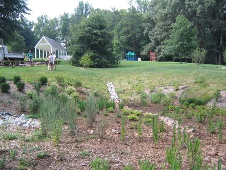
29 4. Retrofit Inventory & Sketch Plans 4.1. Process for Retrofit Inventory Fieldwork was conducted from July 9-11, 2007, and focused on the 24 sites identified in the Scoping & Initial Ranking. Teams consisted of the Center and the following City staff: Kristel Riddervold and Dan Frisbee (Environmental Administration, Department of Public Works), and Chris Gensic and Susan Pleiss (Department of Parks and Recreation). Each team was led by a Center staff person experienced with retrofitting. The latest Retrofit Reconnaissance Investigation (RRI) form was used, and methods outlined in the Urban Stormwater Retrofit Practices were used as guidance (see steps 3 and 4 in Chapter 4 in the manual). Appendix A contains the field guide used by the teams, and Appendix C contains the RRI form used as part of this investigation. Figure 2 shows some representative photos from the retrofit fieldwork. Figure 2. Typical Retrofitting Activities as Part of Charlottesville Public Lands Stewardship Results of Retrofit Inventory Several categories of public land stewardship were identified as part of the retrofit inventory. Table 11 shows the types of projects, number identified, and sites where they are located. Center for Watershed Protection, Page 21
30 Stormwater Retrofits Stormwater retrofits are projects that reduce existing pollutant loads and runoff volume from impervious cover and other land uses. Storage retrofits treat drainage areas ranging from five to 500 acres. On-site retrofits can treat as little as 500 square feet of contributing drainage area. Various types of stormwater retrofit projects were identified as part of this study: rain gardens/bioretention stormwater planters downspout disconnection impervious cover removal swales catch basin inserts perimeter sand filter green roof rainwater harvesting forested stormwater wetland stream stabilization Landscape Management & Stewardship These projects reduce pollutant load from pervious areas by repairing erosion and/or enhancing the water retention capacity of landscapes by improving soil structure and vegetative cover. Various landscape management and stewardship projects identified as part of this study include: reforestation/tree planting/native landscaping designation of no-mow areas soil amendments repair of bare soil and erosion areas Pollution Prevention Pollution prevention projects reduce potential pollutant loads from sources that should be separated from the storm sewer system. Various pollution prevention projects identified as part of this study include: improved dumpster management improved janitorial practices improved materials storage street sweeping clean up of trash and debris Outfall Repairs These projects reduce an existing pollutant load from an unstable outfall. Outfall repair projects identified as part of this study include: outfall stabilization piedmont outfall retrofit (engineered outfall structure that provides stable conveyance as well as stormwater treatment) Unmapped Features Features identified in the field, but not located in the current GIS layers were classified as unmapped. These features included: stormwater inlets and outfalls stormwater manholes stormwater pipes live stream or flowing spring Center for Watershed Protection, Page 22
31 Miscellaneous Observations Observations made during fieldwork that were relevant to a public land stewardship project were noted as miscellaneous observations. These observations include: localized drainage problem specimen trees outfalls in good condition eroding/clogged inlet concrete dumping Center for Watershed Protection, Page 23
32 Table 11. Projects Identified as Part of the Retrofit Inventory Category Type # Identified Sites Bioretention (treat off-site roadway) 1 Greenbrier School Daylight existing storm drain 1 Forest Hills Park Disconnect storm drain to buffer 1 Johnson School Stormwater Retrofits - Storage Stormwater Retrofits On-Site Dry Swale (treat off-site roadway) 1 Burnley-Moran School Stormwater Wetland 2 Tonsler Park Azalea Park Rainwater Harvesting 1 Meadowcreek Park Storage Retrofit (no specific concept) 1 Quarry Park Bioretention/Rain Garden 26 Buford School Burnley-Moran School CHS Clark School Forest Hill Park Greenbrier School Jackson-Via School Johnson School McIntire Park West Pen Park Rives Park Schenk s Greenway Tonsler Park Venable School Washington Park Catch Basin Insert 3 Tonsler Park Downspout Disconnection/Rainwater Harvesting 7 Burnley-Moran School CHS Tonsler Park Venable School Washington Park Green Roof 1 Walker School Impervious Cover Removal 2 Johnson School Tonsler Park Low Flow Outfall 1 Meadowcreek Park Perimeter Sand Filter 1 Pervious Pavement/Porous Pavers 4 Schenk s Greenway/McIntire Recycling Center CHS Johnson School Pen Park Riparian Buffer 1 Azalea Park Stream Stabilization 1 Meade Park Stormwater Planter 3 Clark School Greenbrier School Tonsler Park Water Quality Swale 14 Azalea Park Burnley-Moran School CHS Greenbrier School Center for Watershed Protection, Page 24 Jackson-Via School Johnson School Meade Park
33 Table 11. Projects Identified as Part of the Retrofit Inventory Category Type # Identified Sites Northeast Park Pen Park Tonsler Park Walker School Stormwater Retrofits On-Site (continued) Washington Park Tree Pit 1 Rives Park Infiltration 1 Schenk s Greenway Landscape Management & Stewardship Pollution Prevention Repair Bare Soil & Erosion 7 Designate No-Mow Areas 4 Reforestation/Tree Planting/Native Landscaping Management of inlets, materials, waste 4 15 Burnley-Moran School Clark School Greenbrier School Johnson School Northeast Park Tonsler Park Venable School Burnley-Moran School Jackson-Via School Northeast Park Riverview Park Buford School Burnley-Moran School CHS Clark School Greenbrier School Jackson-Via School Johnson School Meade Park Meadowcreek Park Pen Park Quarry Park Tonsler Park Venable School Washington Park CHS (2) Jordan Park Quarry Park Clean Trash and Debris 1 Jordan Park Relocate Dumpsters/Street Sweeping 3 Johnson School Schenk s Greenway Walker School Center for Watershed Protection, Page 25
34 Table 11. Projects Identified as Part of the Retrofit Inventory Category Type # Identified Sites Outfall Repair Piedmont Outfall Repair 9 Buford School Clark School Greenbrier Park Greenbrier School Jackson-Via School McIntire Park West Pen Park Riverview Park Walker School Outfall Stabilization/Repair 3 CHS Walker School Washington Park Drop Structure to Replace Curb Cut 1 Greenbrier Park Center for Watershed Protection, Page 26
35 5. Retrofit Evaluation & Ranking 5.1. Objectives of Evaluation & Ranking Field work revealed 121 potential projects, 73 of which were stormwater retrofit projects. 2 The evaluation and ranking process puts the potential projects in context and produces a prioritized list. The prioritized list can serve as a guide for implementation because City staff can quickly ascertain which projects best meet the established performance goals. However, it must be understood that a prioritized list is only a guide, and that professional judgment, funding opportunities, and broader City needs also play a strong role in determining which projects should be implemented at a given time. The ranking process only applied to the stormwater retrofit projects, because these could be compared to each other based on pollutant load reductions, cost-effectiveness, and the other screening factors. Other projects, such as pollution prevention and landscape stewardship, also reduce pollutant loads, but are more difficult to quantify and can more easily be built into existing operation and maintenance activities. Table 12 provides the different categories of projects and implementation strategy associated with each. Table 12. Implementation Strategies for the Various Categories of Projects Type of Project Implementation Strategy Projects reduce existing pollutant loads from impervious cover and other Stormwater Retrofits land uses. Implement through CIP, grants, development proffers, and other delivery methods Projects reduce a pollutant load from pervious areas by repairing erosion or enhancing landscapes. Some of these projects can be implemented Landscape Management & through changes in routine activities (e.g., no mow areas). Others can Stewardship be bundled with other CIP or improvement projects (e.g., soil amendments, repair erosion). Projects reduce potential pollutant loads from sources that should be separated from the storm sewer system. The most common example is a Pollution Prevention dumpster leaking solid waste and dumpster juice to a nearby storm drain. These projects should be considered high priority activities that can be implemented through routine O&M activities. Projects reduce an existing pollutant load from an unstable outfall. In many cases, the erosion caused by an outfall extends downstream for a Outfall Repairs long distance. The major impact is the release of large amounts of sediment from eroding channels. These are high priority projects that should be bundled with other CIP projects at the subject properties. 2 Of the 121 total projects, 64 projects had Retrofit Reconnaissance Investigation (RRI) forms completed. These were projects where a retrofit concept was fleshed out. Other projects without RRI forms included landscape management, pollution prevention, unmapped features, miscellaneous observations, simple downspout disconnections, and other projects for which preliminary designs were not conducted. Center for Watershed Protection, Page 27
36 5.2. Identification of Screening Factors & Weights Screening factors were derived directly from the initial performance goals and refined through several meetings with City staff. Each factor was assigned a weight to produce a 100-point scale for ranking. Table 13 provides the selected screening factors, descriptions, and scoring criteria. Primary Screening Factor Pounds of Total Phosphorus (TP) Removed TP used as indicator for other pollutants Cost Effectiveness (per pound of TP treated) Capture of off-site runoff Runoff Reduction Outdoor Learning & Community Outreach Opportunities Secondary Screening Factor Quick Implementation Promotes Bacteria Removal Supports Tree Canopy Goals Desirable Wildlife Habitat Table 13. Scoring Criteria Used for Ranking Description Scoring Screening factor that combines Top Quartile = 10 influence of total impervious area Second Quartile = 7 treated and removal efficiency of Third Quartile = 5 proposed retrofit. Fourth Quartile = 2 Top Quartile (highest cost) = 2 Second Quartile = 5 Cost per pound of TP treated Third Quartile = 7 Whether any off-site runoff is captured and treated Ability of practice to reduce overall volume of runoff through infiltration, absorption, runoff capture & reuse, etc. Whether practice is strategically located on property and has design features that would be of interest to students & community Description Whether property has current funding or planning process underway where retrofit could fit into larger project Practice contains filtering, dessication, or other processes that can remove bacteria Practice would result in NET gain in trees -- trees planted but not removed for construction Practice includes large enough area that can be planted with wildlifefriendly species or create unique habitats (e.g., emergent wetlands) Fourth Quartile (lowest cost) = 10 Capture >= 0.25" of off-site runoff = 10 Capture >= 0.10" of off-site runoff = 5 No off-site runoff captured = 0 Practice includes soil absorption (bioretention), infiltration, or collection = 10 Practice includes filtering, runoff dispersion, or other practice that provides some runoff reduction = 5 Practice does not include these features = 0 Exceptional opportunity = 10 Moderate opportunity = 5 Marginal opportunity = 0 Scoring Good chance for quick implementation = 1 Not at this time = 0 Practice contains features = 1 Practice does not contain features = 0 Trees planting included = 1 Trees not included = 0 Desirable habitat created = 1 Desirable habitat NOT created = 0 Center for Watershed Protection, Page 28
37 Low Maintenance Burden No Permitting Issues Few Site & Utility Constraints No Aesthetic, Nuisance, Safety Issues Promotes innovative practices/lid Table 13. Scoring Criteria Used for Ranking Routine maintenance involves mainly vegetation = 2 Practice does not require frequent cleaning, dredging, excavation, etc. Most maintenance activities involve vegetation (pruning, weeding, etc.) Permits for activities in streams, wetlands, flood plains, steep slopes not likely RRI does not identify utility Routine maintenance involves vegetation + some periodic cleaning/unclogging of pipes = 1 Maintenance involves periodic dredging or excavation = 0 Permits not likely = 1 Permits likely = 0 No utility conflicts identified = 1 conflicts at location of practice Utility conflicts identified = 0 Practice does not include standing No issues identified = 1 water, mosquito habitat, steep dropoffs, attractive nuisances, etc. Issues identified = 0 Practice promotes the concept of decentralized runoff treatment and reduction LID promoted = 1 LID not necessarily promoted = Deriving Data for Pollutant Load Reductions & Costs Appendices B, D, and E of the Urban Stormwater Retrofit Practices manual were used to derive data for pollutant load reductions and costs, and were supplemented with research on additional BMPs. The intent was to use the best available data to produce planninglevel estimates for both pollutant reductions and cost. Pollutant loads were estimated using the Simple Method equation shown in Box 1 and the Virginia-specific parameters in Table 14. Box 1. Simple Method Equation used to estimate Pollutant Loads L = [(P)(Pj)(Rv) (12)](C)(A)(2.72) 12 and 2.72 are unit conversion factors Rv = (I) Table 14. Pollutant Load Calculation Parameters used in the Simple Method Parameter Parameter Description VA Variables P Precipitation (in/yr) 43 P j Fraction of Runoff Producing Events 0.9 I Site Imperviousness (%) Site Dependent R v Runoff Coefficient Site Dependent Mean Concentration of TP (mg/l) 0.28 C Mean Concentration of TN (mg/l) 2.67 Mean Concentration of ZN (mg/l) 0.15 Mean Concentration of TSS (mg/l) 43 A Area (acres) Site Dependent Center for Watershed Protection, Page 29
38 The pollutant removal capabilities and unit costs of various BMPs are provided in Tables 15 and 16, respectively. A spreadsheet for each inventoried site was created based on these data to document the pollutant removal and planning-level cost for each identified project. An example of the spreadsheet is provided in Table 17 for the projects identified at CHS. Section 8 contains a detailed catalog of all sites inventoried as part of this study. Table 15. Unit Costs of Various BMPs (Derived from USRM Manual 3, Appendix E, Table E.4, Median Cost, except where noted) Unit Cost Practice Qualifier ($/cf treated) Notes (references to USRM Manual 3) Bioretention/Rain < 0.5 ac Garden treated $30.00 Table E.4 & Section D.1 Bioretention/Rain > 0.5 ac Garden treated $10.50 Table E.4 & Section D.3 Water Quality Swale engineered swale $10.50 same as bioretention Piedmont Outfall similar to Costs not included Manual 3. Cost derived from coastal plain $13.00 sample plan & unit cost estimates outfall Catch Basin Insert $4.00 Downspout Disconnection to Landscaping/Turf Downspout Disconnection to Rain Barrel Rainwater Harvesting ft 2 of rooftop, 1" of rainfall, $50/disconn ection 1 or several 55-gallon barrels cistern or larger storage device From EPA Website: mps/index.cfm?action=browse&rbutton=detail &bmp=77 $1.00 Derived from programs evaluated in Portland $25.00 $15.00 Impervious Cover Removal $20.00 Perimeter Sand Filter $20.00 Pervious Pavement $ Reforestation/Tree Planting/Native Landscaping $5.00 Stormwater Planter $27.00 Constructed Wetland $7.00 Soil Amendments $7.50 Dry Wells/French Drains $11.50 Based on guidance in the Chesapeake Bay Riparian Handbook and Portland Manual Center for Watershed Protection, Page 30
39 Table 16. Pollutant Removal Efficiency of Various BMPs (Derived from USRM Manual 3, Appendix D, appropriate table, except where noted) Practice Qualifier TP TN Zn TSS Notes Bioretention/Rain Garden Bioretention/Rain Garden < 0.5 ac treated > 0.5 ac treated 45% 45% 80% 60% 45% 45% 80% 60% TP & TN from proposed VA system for Bioretention #1. Zn & TSS from Appendix D. TP & TN from proposed VA system for Bioretention #1. Zn & TSS from Appendix D. Water Quality engineered 45% 55% 70% 80% Swale swale similar to Remedial strategy that is not C'ville Outfall coastal plain quantifiable. outfall Catch Basin Insert 15% 10% 15% 30% Best professional judgment. Downspout Based on VA volume reduction Disconnection to 20% 20% 20% 20% LID credit. Landscaping/Turf Downspout Disconnection to Rain Barrel Rainwater Harvesting 1 or several 55-gallon barrels cistern or larger storage device 10% 10% 10% 10% 25% 25% 25% 25% Impervious Cover Removal Perimeter Sand Filter 60% 30% 90% 85% Pervious Pavement 65% 40% 65% 90% Reforestation/Tree Planting/Native Landscaping Stormwater Planter 25% 25% 40% 30% Constructed Wetland Based on VA volume reduction LID credit. Based on VA volume reduction LID credit. 90% 90% 90% 90% Best professional judgment. 45% 25% 40% 70% Soil Amendments 20% 20% 20% 20% Dry Wells/French Drains 45% 45% 80% 60% Remedial strategy that is not quantifiable. Assumed to have approximately half the efficiency of rain gardens. TP from proposed VA system for Constructed Wetland #1. TN, Zn & TSS from Appendix D. Best professional judgment - Assumed similar efficiency as disconnection to landscaping/turf Best professional judgment - Assumed similar efficiency as rain gardens. Center for Watershed Protection, Page 31
40 Table 17. Pollutant Load and Cost Data Example from CHS Site Parameters CHS-06 CHS-07 CHS-09 Total Impervious Cover of Combined Treatment Areas (ac) Impervious Percent of Combined Treatment Areas (whole #) Recommended Retrofits Rain Garden Rainwater Harvesting Swale/Rain Garden TP Removal Efficiency 45% 25% 45% TN Removal Efficiency 45% 25% 45% Zn Removal Efficiency 80% 25% 80% TSS Removal Efficiency 60% 25% 60% Volume Treated (cubic feet) 5, ,920 Unit Cost ($/cubic foot) $10.50 $15.00 $30.00 Cost per Impervious Acre $34,780 $54,359 $110,400 $46,811 Cost Estimate $55,997 $25,005 $27,600 $108,602 Pollutant Load Calculation Parameters (pre-retrofit) P Precipitation (in/yr) P j Fraction of Runoff Producing Events I Site Imperviousness (%) R v Runoff Coefficient Mean Concentration of TP (mg/l) C Mean Concentration of TN (mg/l) Mean Concentration of ZN (mg/l) Mean Concentration of TSS (mg/l) A Area (acres) TP Pre-Retrofit Load (lb/yr) Post-Retrofit Load (lb/yr) Load Removed (lb/yr) Load Removed Check (lb/yr) Percent Reduction 41% Cost Per lb Treated $33,124 $93,186 $105,142 $48,890 TN Pre-Retrofit Load (lb/yr) Post-Retrofit Load (lb/yr) Load Removed (lb/yr) Load Removed Check (lb/yr) Cost Per lb Treated $3,474 $9,772 $11,026 $5,127 Zinc Pre-Retrofit Load (lb/yr) Post-Retrofit Load (lb/yr) Load Removed (lb/yr) Load Removed Check (lb/yr) Cost Per lb Treated $34,780 $173,946 $110,399 $54,199 TSS Pre-Retrofit Load (lb/yr) Post-Retrofit Load (lb/yr) Load Removed (lb/yr) Load Removed Check (lb/yr) Cost Per lb Treated $162 $607 $513 $246 Center for Watershed Protection, Page 32
41 5.4. Scoring Scores were entered for each screening factor by a Center staff person that was familiar with the particular sites. Table 18 provides a scoring form example from Buford School. A master spreadsheet was developed that could be used to view individual site data as well as compare projects across sites. Table 18. Scoring Form Example from Buford School Screening Factor Weight Score (0-10) Weighted Score Total Pounds of TP Removed Cost Effectiveness (per pound of TP treated) Capture of off-site runoff Runoff Reduction Outdoor Learning & Community Outreach Opportunities Quick Implementation Promotes Bacteria Removal Supports Tree Canopy Goals Desirable Wildlife Habitat Low Maintenance Burden No Permitting Issues Few Site & Utility Constraints No Aesthetic, Nuisance, Safety Issues Promotes innovative practices/lid TOTAL 73 Bold = Primary Screening Factor Italics = Secondary Screening Factor 5.5. Ranking of Projects After all the scores were entered into the master scoring spreadsheet, a list of projects was produced with individual and total scores (see Table 19). A meeting was held on October 2, 2007 to review the ranked projects and discuss the strongest candidates for design work. Several factors were discussed at this meeting, including representation of different types of BMPs, representation across parks and schools, sites that had early implementation opportunities and/or ongoing master plans, and staff preferences. Subsequently, site visits were conducted on October 15 to look at the candidate sites in the field. Through a series of discussions, the candidate sites were selected. Detailed scoring for each site can be found in Appendix D. Photographs of several highly-ranked sites are shown in Figure 3. Center for Watershed Protection, Page 33
42 Table 19. Individual Project Ranking Site Name Description Project ID TOTAL Meadowcreek Park cistern from hotel parking lot MW Azalea Park stormwater wetland AZ Schenks Greenway rain gardens along path SC Buford School pool building BU Charlottesville High School rain MLK PA center CHS Johnson School amphitheatre JO Jordan Park expanded buffer, divert road runoff JR Pen Park bioretention at parking lot PP Forest Hills Park daylight pipe, create swale FH Tonsler Park forested wetland TO McIntire Park West bioretention, small parking lot MPW Pen Park bioretention at parking lot PP McIntire Park West bioretention MPW-01b 68 Tonsler Park rain gardens TO-02a 67 Venable School disconnect downspouts VN-02c 67 Venable School disconnect downspouts VN-02b 65.5 Johnson School IC removal JO-02b 64.5 Burnley-Moran School asphalt channel BM-02b 64 Jackson-Via School bioretention, swale JV-02a/b 63 Burnley-Moran School swale for roadway BM Clark School rain playground CS-02b 62 Rives Park rain gardens RI Charlottesville High School cistern at track CHS Venable School downspout disconnection VN-02a 56.5 Greenbrier School retrofit existing grass channel GS-02c 56 Greenbrier School bioretention for roadway GS Northeast Park retrofit existing grass channel NO Buford School rain gardens, improve vegetation BU Meade Park bioswale for roadway ME Tonsler Park downspout disconnection TO-02c 53.5 McIntire Park West terraced bioretention MPW-01a 53 Schenks Greenway sand Recycling Center SC Burnley-Moran School rain roof BM-02d 52 Pen Park porous pavement PP Burnley-Moran School downspout disconnection BM-02a 48 Tonsler Park retrofit existing grass channel TO-02d 46.5 Charlottesville High School swale/rain garden near entrance CHS Venable School driveway VN-02d 45.5 Center for Watershed Protection, Page 34
43 Table 19. Individual Project Ranking Site Name Description Project ID TOTAL Greenbrier School retrofit existing rain garden GS-02b 45 Clark School rain garden for roof CS-02a 44 Clark School stormwater planters CS-02d 44 Greenbrier School stormwater planter GS-02d 44 Venable School parking lot VN Johnson School porous pavement JO-02a 43.5 Burnley-Moran School retrofit concrete channel BM-02c 40 Washington Park roadway bioretention WP Clark School terraced bioretention CS Tonsler Park hardscape retrofit TO-02e 32 Tonsler Park stormwater planters TO-02b 29.5 Tonsler Park DI inserts TO-02f 23 Projects in Bold are the highest ranked. Projects in Italics are not highly ranked as stand-alone projects, but may support (be bundled together with) other highly-ranked projects for a particular site. Center for Watershed Protection, Page 35


")
 Pen Park bioretention at")


44 A B C D E F Figure 3. Examples of highly ranked sites: (A) Buford School bioswale at pool building, (B) Forest Hills Park daylighting and bioswale, (C) Azalea Park wetland swale, (D) Pen Park bioretention at parking lot, (E) Burnley-Moran School step rain gardens, and (F) Venable School downspout disconnection. Center for Watershed Protection, Page 36
The Art and Science of Stormwater Retrofitting
 The Art and Science of Stormwater Retrofitting April 9, 2008 Michael Novotney, Center for Watershed Protection Deb Caraco, Center for Watershed Protection Dan Frisbee, City of Charlottesville, Virginia
The urban parks in Charlottesville include Jackson Park, Lee Park, and McGuffey Park.
 Park Classifications Charlottesville s parks can be grouped into 4 different classifications: urban parks, neighborhood parks, community parks, and regional parks. Figure 1 on page 5 inventories the facilities
Stormwater Retrofitting: The Art of Opportunity. Presented by the Center for Watershed Protection
 Stormwater Retrofitting: The Art of Opportunity Presented by the Center for Watershed Protection What Are Stormwater Retrofits? Retrofits are stormwater management measures inserted in an urban or ultra-urban
Arlington County Watershed Retrofits. Greg Hoffmann Center for Watershed Protection
 Arlington County Watershed Retrofits Greg Hoffmann Center for Watershed Protection March 18, 2010 About the Center for Watershed Protection Non-profit 501(c)3, non-advocacy organization Work with watershed
Chapter 3 Site Planning and Low Impact Development
 CHAPTER 3 Site Planning and Low Impact Development Chapter 3 Site Planning and Low Impact Development 3.0 Introduction The City of Charleston requires that major residential, large commercial (>1 acre),
Draft Rhode Island Stormwater Design and Installation Standards Manual
 Draft Rhode Island Stormwater Design and Installation Standards Manual Summary The May 2009 Public Review Draft version of the RI Stormwater Design and Installation Standards Manual consists of approximately
When planning stormwater management facilities, the following principles shall be applied where possible.
 2.0 Principles When planning stormwater management facilities, the following principles shall be applied where possible. 2.0.1 Drainage is a regional phenomenon that does not respect the boundaries between
Stormwater Management Techniques WMPF LAND USE TRAINING INSTITUTE MARCH 14, 2018
 Stormwater Management Techniques WMPF LAND USE TRAINING INSTITUTE MARCH 14, 2018 Potential Impacts of New Development Urban development can significantly increase stormwater runoff Water quality considerations
Appendices: Glossary. General Terms. Specific Terms. Low Impact Development Approaches Handbook
 67 67 General Terms Specific Terms 66 Low Impact Development Approaches Handbook The vocabulary of low impact development is evolving, and many terms are used interchangeably and to describe the same or
Update for City Council 7 Years of Progress. May 2013
 Update for City Council 7 Years of Progress May 2013 Setting the Stage Needs Assessment 2006 City of Charlottesville Inventory National Guideline Service Level School Sites Inventory Total Current Inventory
Green Infrastructure & Low Impact Development
 Green Infrastructure & Low Impact Development CITY OF COVINGTON STORMWATER MANAGEMENT WHAT IS GREEN INFRASTRUCTURE? Green infrastructure uses vegetation, soils and natural processes to manage water and
USF System Campus Master Plan Updates Goals, Objectives and Policies
 2015-2025 USF System Campus Master Plan Updates Goals, Objectives and Policies Tampa Goals, Objectives, and Policies Table of Contents Executive Summary 2015 2025 USF Campus Master Plan Update Introduction
STORMWATER MANAGEMENT CODES ANALYSIS RICHLAND COUNTY, SC SITE PLANNING ROUNDTABLE
 STORMWATER MANAGEMENT CODES ANALYSIS RICHLAND COUNTY, SC SITE PLANNING ROUNDTABLE Codes analyses for each subcommittee were completed to assist participants of the Richland County Site Planning Roundtable.
4. CONCEPT PLAN DEVELOPMENT
 4. CONCEPT PLAN DEVELOPMENT Concept Plan Step 1: Identify Site Constraints and Opportunities Review the existing site to identify constraints and opportunities for GI Practices to meet the RRv. Constraints
New Development Stormwater Guidelines
 New Development Stormwater Guidelines CITY OF MOUNTLAKE TERRACE Table of Contents Introduction... 2 Ecology s Minimum Requirements for stormwater management... 2 Description of the 9 Minimum Requirements...
Green City, Clean Waters
 Green City, Clean Waters Green Infrastructure Maintenance Manual Consent Order & Agreement Deliverable VIII City of Philadelphia Combined Sewer Overflow Long Term Control Plan Update Submitted to The Commonwealth
SECTION A-1: DESCRIPTION
 URBAN BIORETENTION Stormwater Planters Expanded Tree Pits Stormwater Curb Extensions VERSION 1.0 SECTION A-1: DESCRIPTION Urban bioretention practices are similar in function to regular bioretention practices
NEORSD Green Infrastructure Grant (GIG) Program Opening Remarks
 Program Opening Remarks") NEORSD Green Infrastructure Grant (GIG) Program Opening Remarks 2019 NEORSD GIG Eligibility and Technical Requirements Project must be located in the Sewer District s combined sewer area Location Applicant
NEORSD Green Infrastructure Grant (GIG) Program Opening Remarks 2019 NEORSD GIG Eligibility and Technical Requirements Project must be located in the Sewer District s combined sewer area Location Applicant
VA DCR STORMWATER DESIGN SPECIFICATION NO. 11 WET SWALE. VERSION 2.0 January 1, 2013 SECTION 1: DESCRIPTION
 VIRGINIA DCR STORMWATER DESIGN SPECIFICATION No. 11 VERSION 2.0 January 1, 2013 SECTION 1: DESCRIPTION Wet swales can provide runoff filtering and treatment within a conveyance system and are a cross between
Impervious Cover Assessment and Reduction Action Plan for Woodstown, New Jersey
 Impervious Cover Assessment and Reduction Action Plan for Woodstown, New Jersey Christopher C. Obropta, Ph.D., P.E. obropta@envsci.rutgers.edu www.water.rutgers.edu March 24, 2015 Rutgers Cooperative Extension
APPENDIX A SIMPLIFIED APPROACH TO STORMWATER MANAGEMENT FOR SMALL PROJECTS. In West Sadsbury Township, Chester County, Pennsylvania
 APPENDIX A SIMPLIFIED APPROACH TO STORMWATER MANAGEMENT FOR SMALL PROJECTS In West Sadsbury Township, Chester County, Pennsylvania TABLE OF CONTENTS I. Introduction 3 II. Importance of Stormwater Management
Draft Impervious Cover Reduction Action Plan for West Long Branch Borough, Monmouth County, New Jersey
 Draft Impervious Cover Reduction Action Plan for West Long Branch Borough, Monmouth County, New Jersey Prepared for West Long Branch Borough by the Rutgers Cooperative Extension Water Resources Program
Beyond Rain Gardens Advancing the Use of Compost for Green Infrastructure, Low Impact Development, & Stormwater Management
 Beyond Rain Gardens Advancing the Use of Compost for Green Infrastructure, Low Impact Development, & Stormwater Management VORS 2018 Stormwater Management Session 2 Stormwater Management, Green Infrastructure,
Appendix E: Illustrative Green Infrastructure Examples
 Appendix E: Illustrative Green Infrastructure Examples Integrating LID into San Francisco s Urban Landscape Figure E. High-density Residential Figure E. Low-density Residential Figure E. Mixed Use 7 Figure
Impervious Cover Reduction Action Plan for City of Vineland, Cumberland County, New Jersey
 Impervious Cover Reduction Action Plan for City of Vineland, Cumberland County, New Jersey Prepared for the City of Vineland by the Rutgers Cooperative Extension Water Resources Program May 23, 2016 Table
Chapter 4 - Preparation of Stormwater Site Plans
 Chapter 4 - Preparation of Stormwater Site Plans The Stormwater Site Plan is the comprehensive report containing all of the technical information and analysis necessary for the City to evaluate a proposed
Appendix I. Checklists
 Appendix I Checklists Town of Greenwich Drainage Manual Department of Public Works - Engineering Division Town Hall - 101 Field Point Road, Greenwich, CT 06836-2540 Phone 203-622-7767 - Fax 203-622-7747
ST. MARY S SOIL CONSERVATION DISTRICT (SMSCD) AND DPW&T CONCEPT EROSION AND SEDIMENT CONTROL AND STORMWATER MANAGEMENT GUIDELINES AND CHECKLIST
 AND DPW&T CONCEPT EROSION AND SEDIMENT CONTROL AND STORMWATER MANAGEMENT GUIDELINES AND CHECKLIST") St. Mary s Soil Conservation District 26737 Radio Station Way, Suite B Leonardtown, MD 20650 Phone: 301-475-8402 ext. 3 Fax: 301-475-8391 www.stmarysscd.com St. Mary s County Government Department of Public
St. Mary s Soil Conservation District 26737 Radio Station Way, Suite B Leonardtown, MD 20650 Phone: 301-475-8402 ext. 3 Fax: 301-475-8391 www.stmarysscd.com St. Mary s County Government Department of Public
Working Group Meeting
 April 4,, 2017 Parks Operations Bldg Working Group Meeting Arts Districts Overview Stormwater/RPA/Stream Considerations First Principles Agenda 7:00pm 7:05pm 7:10pm 7:40pm 8:30pm 9:40pm 9:45pm Welcome
WEFTEC.06. ** City of Caldwell, Idaho
 COST-BENEFIT ANALYSIS OF URBAN STORMWATER RETROFITS AND STREAM DAYLIGHTING USING LOW IMPACT DEVELOPMENT TECHNOLOGIES Sherrill Doran*, Dennis Cannon** * CH2M HILL, 322 East Front Street, Suite 200 Boise,
2016 WORKSHOP LVR Field Trip
 2016 WORKSHOP LVR Field Trip ***Note*** Many of the sites on this tour were NOT related to, or funded by, the DGLVR program. They are being shown to encourage discussion about the kinds of projects that
Non-Residential&Multi-Family PropertyCreditManual
 CityofRichmond DepartmentofPublicUtilities StormwaterManagementProgram Non-Residential&Multi-Family PropertyCreditManual ApprovedFebruary2011 City of Richmond Stormwater Non-Residential & Multi-Family
Stormwater and Ecological Management Opportunities May 2008
 Stormwater and Ecological Management Opportunities May 2008 University of Delaware Newark Campus Stormwater and Ecological Observations Unique geologic setting on fall line (divide between Piedmont and
Draft Impervious Cover Reduction Action Plan for West New York, Hudson County, New Jersey
 Draft Impervious Cover Reduction Action Plan for West New York, Hudson County, New Jersey Prepared for the Town of West New York by the Rutgers Cooperative Extension Water Resources Program March 29, 2017
HUDSON VALLEY REGIONAL COUNCIL 3 Washington Center, Newburgh NY
 PROJECT AREA: HYDE PARK HUDSON VALLEY REGIONAL COUNCIL 3 Washington Center, Newburgh NY 12550 http://www.hudsonvalleyregionalcouncil Insert aerial site photo with streets labeled GREEN INFRASTRUCTURE CONCEPT
Swan Creek Urban BMP Inventory and Assessment. Jeff Grabarkiewicz, Kari Gerwin, Ann-Drea Hensley TMACOG, Lucas SWCD/Engineers, and Partners
 Swan Creek Urban BMP Inventory and Assessment Jeff Grabarkiewicz, Kari Gerwin, Ann-Drea Hensley TMACOG, Lucas SWCD/Engineers, and Partners Presentation Outline Project Background Methods Inventory Desktop
Slow it, Spread it, Sink it using Green Stormwater Infrastructure
 Milly Archer Water Resources Coordinator Becky Tharp Green Infrastructure Collaborative Slow it, Spread it, Sink it using Green Stormwater Infrastructure Overview Defining LID and GSI Hydrology and impacts
Rice Lake Subwatershed Stormwater Retrofit Assessment
 Rice Lake Subwatershed Stormwater Retrofit Assessment Prepared for the Rice Creek Watershed District by The Anoka Conservation District With Assistance From: The Metropolitan Landscape Restoration Program
4.6. Low Impact and Retentive Grading
 4.6. Low Impact and Retentive Grading Low Impact Grading techniques focus on utilizing existing topography during Site layout to minimize cost. Proposing structures, roads, and other impervious surfaces
West Virginia Stormwater Management Manual: Methods.
 West Virginia Stormwater Management Manual: Methods Created to deliver targeted training on new tools and practices to improve the quality of stormwater runoff. www.cbstp.org www.chesapeakestormwater.net
Pennsylvania Stormwater Best Management Practices Manual
 Pennsylvania Stormwater Best Management Practices Manual DRAFT - JANUARY 2005 Section 4 Comprehensive Stormwater Management: Integrating Site Design, Non-Structural, and Structural BMP's This page intentionally
Inspection and Maintenance of Stormwater Best Management Practices
 FAC T S H E E T Inspection and Maintenance of Stormwater Best Management Practices is a general term that refers to vegetated stormwater best management practices (BMPs) that temporarily store rainwater
Directors Rules for Seattle Municipal Code, Chapters Stormwater Code
 Directors Rules for Seattle Municipal Code, Chapters 22.800 22.808 Stormwater Code Requirements for Green Stormwater Infrastructure to the Maximum Extent Feasible for Single-Family Residential and Parcel-Based
Bioretention cell schematic key
 Bioretention Cells Bioretention cell schematic key 1 3 Hardwood mulch 2 Curb cut 3 18-30 Modified soil 4 Stone aggregate choker layer 5 Stone aggregate base layer 6 Subdrain 7 Undisturbed soil 8 Overflow/Cleanout
Post Construction BMPs
 Post Construction BMPs Why are Post Construction BMPs important? With increased development brings the increase of impervious cover Parking lots, rooftops, driveways Storm water runoff volume increases
Problem Understanding
 Introduction...2-1 Previous Data and Mapping...2-2 Known Problem Areas...2-3 Resident Survey.2-3 Introduction The Village of Downers Grove stormwater system includes storm sewers, streams, wetlands, roadway
J. Paul Guyer, P.E., R.A.
 J. Paul Guyer, P.E., R.A. Paul Guyer is a registered civil engineer, mechanical engineer, fire protection engineer, and architect with over 35 years experience in the design of buildings and related infrastructure.
FACT SHEET: Pervious Pavement with Infiltration
 FACT SHEET: Pervious Pavement with Infiltration DESCRIPTION Pervious pavement is a Green Infrastructure (GI) technique that combines stormwater infiltration, storage, and structural pavement consisting
Evaluating Low Impact Development Practices for Stormwater Management on an Industrial Site in Mississippi
 Evaluating Low Impact Development Practices for Stormwater Management on an Industrial Site in Mississippi Dennis S. Painter, Tennessee Valley Authority, Nashville, Tennessee Donald Becker, Tennessee Valley
BLACK/HARMONY/FAREWELL CREEK WATERSHED EXISTING CONDITIONS REPORT CHAPTER 5 IMPERVIOUS SURFACES
 BLACK/HARMONY/FAREWELL CREEK WATERSHED EXISTING CONDITIONS REPORT CHAPTER 5 IMPERVIOUS SURFACES Draft November 2009 TABLE OF CONTENTS 1.0 INTRODUCTION... 3 2.0 STUDY AREA AND SCOPE... 4 3.0 METHODOLOGY...
HEALTH SCIENCES BUILDING REDEVELOPMENT PROJECT
 INTRODUCTION In recent years, the University of Cincinnati (University) has demonstrated a commitment to identifying and implementing sustainable goals and objectives throughout University s Uptown Campuses.
n1. Design 5.4.6a Urban Bioretention 5.4.6a Urban Bioretention Variations: Planter box, Extended tree pits, Stormwater curb extensions.
 5.4.6a Urban Bioretention Variations: Planter box, Extended tree pits, Stormwater curb extensions. Description: Urban bioretention SCM are similar in function to regular bioretention practices except they
Homeowners Guide to Stormwater BMP Maintenance
 Homeowners Guide to Stormwater BMP Maintenance What You Need to Know to Take Care of Your Property Rain Barrel Dry Well Rain Garden Pervious Asphalt Porous Pavers City of El Monte Stormwater BMP Management
Butchers Hill. Greening Feasibility FINAL REPORT MAY 2009 N PORT ST N WOLFE ST S MADEIRA ST. Submitted To: Submitted By:
 S WOLFE ST N CASTLE ST N WASHINGTON ST S WASHINGTON ST S CHAPEL ST S DURHAM ST S DUNCAN ST N MADEIRA ST N MONTFORD AVE Butchers Hill Greening Feasibility N DUNCAN ST MULLIKIN ST N PORT ST N WOLFE ST E
Potential Green Infrastructure Strategies May 6, 2015 Workshop
 Potential Green Infrastructure Strategies May 6, 2015 Workshop Background The City of Cortland is developing the Tioughnioga Urban Headwaters Green Infrastructure Action Plan with funding from the National
LOUISIANA STATE UNIVERSITY COMPREHENSIVE & STRATEGIC CAMPUS MASTER PLAN. APPENDIX G - Stormwater Study Findings & Stormwater Solutions
 LOUISIANA STATE UNIVERSITY COMPREHENSIVE & STRATEGIC CAMPUS MASTER PLAN APPENDIX G - Stormwater Study Findings & Stormwater Solutions LSU: MP Narrative July 2017 3.5 Open Space Existing Conditions The
ROOFTOP DISCONNECTION VERSION 1.5
 DRAFT VA DCR STORMWATER DESIGN SPECIFICATION No. 1 ROOFTOP DISCONNECTION VERSION 1.5 Note to Reviewers of the Stormwater Design Standards and Specifications The Virginia Department of Conservation and
FINAL REPORT Stormwater Retrofit Opportunities on Public Lands in Fluvanna County
 FINAL REPORT Stormwater Retrofit Opportunities on Public Lands in Fluvanna County NOVEMBER 2010 PREPARED BY: Center for Watershed Protection 8390 Main Street, 2 nd floor Ellicott City, MD 21043 SUBMITTED
Coffee Creek Park Development Low Impact Development (LID)
") Coffee Creek Park Development Low Impact Development (LID) City of Duluth, St. Louis County, MN Presented By: Christopher J. Rousseau, P.E. February 27, 2008 Developer / Owner Information Trinity Development
Coffee Creek Park Development Low Impact Development (LID) City of Duluth, St. Louis County, MN Presented By: Christopher J. Rousseau, P.E. February 27, 2008 Developer / Owner Information Trinity Development
INTRODUCTION TO GREEN INFRASTRUCTURE HOW WE CAN PROTECT OUR COMMUNITIES AND OUR WATERS Maywood Public Library Bergen County, New Jersey
 INTRODUCTION TO GREEN INFRASTRUCTURE HOW WE CAN PROTECT OUR COMMUNITIES AND OUR WATERS Maywood Public Library Bergen County, New Jersey Jeremiah D. Bergstrom, LLA, ASLA Rutgers Cooperative Extension Water
Camden SMART Initiative Stormwater Management and Resource Training
 Camden SMART Initiative Stormwater Management and Resource Training www.camdensmart.com Camden s Struggle with Stormwater 1 The City of Camden is served by a combined sewer system, which uses the same
Pennsylvania Stormwater Best Management Practices Manual. Chapter 4. Integrating Site Design and Stormwater Management
 Pennsylvania Stormwater Best Management Practices Manual Chapter 4 Integrating Site Design and Stormwater Management 363-0300-002 / December 30, 2006 Chapter 4 Integrating Site Design and Stormwater Management
A Review of Green Infrastructure Projects Implemented in the Grand Traverse Region
 A Review of Green Infrastructure Projects Implemented in the Grand Traverse Region Sarah U Ren Program Director The Watershed Center of Grand Traverse Bay 231-935-1514, suren@gtbay.org Our Mission: The
GREEN ON THE HORIZON. Challenges of Integrating LID into New Development. Southeast Stormwater Association
 GREEN ON THE HORIZON Challenges of Integrating LID into New Development Southeast Stormwater Association Annual Seminar, Charleston SC October 9, 2014 JENNIFER A. NUNN, PE THE BALMORAL GROUP Acknowledgments
Key elements : Filter Strips must be designed within parameters required by the Fort Wayne s Development Standards/Criteria Manual.
 4.4. Filter Strips Filter Strips are densely vegetated lands that treat sheet flow storm water from adjacent pervious and impervious areas. They function by slowing runoff, trapping sediment and pollutants,
MANUAL OF DESIGN, INSTALLATION, AND MAINTENANCE REQUIREMENTS FOR STORMWATER MANAGEMENT PLANS
 MANUAL OF DESIGN, INSTALLATION, AND MAINTENANCE REQUIREMENTS FOR STORMWATER MANAGEMENT PLANS May 2007 SECTION 1 Responsibility of Applicant TABLE OF CONTENTS A. Stormwater Management Plan Required Information
Green Infrastructure Overview
 Green Infrastructure Overview Christopher C. Obropta, Ph.D., P.E. obropta@envsci.rutgers.edu Jeremiah Bergstrom, LLA, ASLA jbergstrom@envsci.rutgers.edu February 26, 2016 Water Resources Program NJDEP
Draft. Impervious Cover Reduction Action Plan for Dunellen Borough, Middlesex County, New Jersey
 Draft Impervious Cover Reduction Action Plan for Dunellen Borough, Middlesex County, New Jersey Prepared for Dunellen Borough by the Rutgers Cooperative Extension Water Resources Program September 22,
ROOFTOP (IMPERVIOUS SURFACE) DISCONNECTION
 DISCONNECTION") VIRGINIA DCR DEQ STORMWATER DESIGN SPECIFICATION No. 1 ROOFTOP (IMPERVIOUS SURFACE) DISCONNECTION VERSION 2.0 July 1, 2013 SECTION 1: DESCRIPTION This strategy involves managing runoff close to its source
VIRGINIA DCR DEQ STORMWATER DESIGN SPECIFICATION No. 1 ROOFTOP (IMPERVIOUS SURFACE) DISCONNECTION VERSION 2.0 July 1, 2013 SECTION 1: DESCRIPTION This strategy involves managing runoff close to its source
4.5 City of Indianapolis Stormwater Green Infrastructure Guidance: Bioretention (rain gardens) Bioretention Fact Sheet Bioretention Technical Design
 Bioretention Fact Sheet Bioretention Technical Design") 4.5 City of Indianapolis Stormwater Green Infrastructure Guidance: Bioretention (rain gardens) Bioretention Fact Sheet Bioretention Technical Design Specification Bioretention O & M Manual Draft Green
4.5 City of Indianapolis Stormwater Green Infrastructure Guidance: Bioretention (rain gardens) Bioretention Fact Sheet Bioretention Technical Design Specification Bioretention O & M Manual Draft Green
DCBP APPENDIX B Action Plan for Retrofitting Structural BMPs
 DCBP Appendix FINAL US Army Garrison, Hawaii October 2015 DCBP APPENDIX B Action Plan for Retrofitting Structural BMPs Storm Water Management Plan DCBP Appendix B ACTION PLAN FOR RETROFITTING STRUCTURAL
Putting a LID on Stormwater Pollution. Michele Loudenback, RPES Stormwater Enforcement Water Quality Division
 Putting a LID on Stormwater Pollution Michele Loudenback, RPES Stormwater Enforcement Water Quality Division Outline Brief Regulatory History Conventional vs. Green Practices LID/GI Controls in Use Clean
Introduction to Low Impact Development. Fred Milch. East Central Florida Regional Planning Council
 Introduction to Low Impact Development Fred Milch East Central Florida Regional Planning Council Low Impact Development (LID) Low impact development (LID) is a term used to describe a land planning and
Draft Impervious Cover Reduction Action Plan for Newark, Essex County, New Jersey Volume 3
 Draft Impervious Cover Reduction Action Plan for Newark, Essex County, New Jersey Volume 3 Prepared for the City of Newark by the Rutgers Cooperative Extension Water Resources Program April 16, 2018 Table
Horsley Witten Group Sustainable Environmental Solutions. Rich Claytor, P.E. Janet Bernardo, P.E. horsleywitten.com
 Horsley Witten Group Sustainable Environmental Solutions Rich Claytor, P.E. Janet Bernardo, P.E. horsleywitten.com 857-263-8193 Agenda Introduction & Grant Goals Stormwater & GI Overview Grant Work Completed
DEALING WITH STORM WATER MANAGEMENT
 December 2012 DEALING WITH STORM WATER MANAGEMENT This fact sheet provides information on the guiding principles of storm water management practices, explains the difference between structural and non-structural
Contents. Adapted/abbreviated from GSWMM Coastal Stormwater Supplement, August
 CH. 3 STORMWATER MANAGEMENT PRACTICES Contents Soil Restoration... 30 Site Reforestation/Revegetation... 32 Green Roofs... 35 Permeable Pavements... 37 Undisturbed Pervious Areas... 44 Vegetated Filter
Draft Impervious Cover Reduction Action Plan for Newark, Essex County, New Jersey Volume 2
 Draft Impervious Cover Reduction Action Plan for Newark, Essex County, New Jersey Volume 2 Prepared for the City of Newark by the Rutgers Cooperative Extension Water Resources Program April 16, 2018 Table
Impervious Cover Reduction Action Plan for Hampton Township, Sussex County, New Jersey
 Impervious Cover Reduction Action Plan for Hampton Township, Sussex County, New Jersey Prepared for Hampton Township by the Rutgers Cooperative Extension Water Resources Program November 8, 2016 Table
CITY OF TUMWATER 555 ISRAEL RD. SW, TUMWATER, WA (360) (360) (FAX)
 (360) (FAX)") CITY OF TUMWATER 555 ISRAEL RD. SW, TUMWATER, WA 98501 (360) 754-4180 (360) 754-4126 (FAX) Email: cdd@ci.tumwater.wa.us APPENDIX II-C SHORT FORM CONSTRUCTION STORMWATER POLLUTION PREVENTION PLAN (SWPPP)
CITY OF TUMWATER 555 ISRAEL RD. SW, TUMWATER, WA 98501 (360) 754-4180 (360) 754-4126 (FAX) Email: cdd@ci.tumwater.wa.us APPENDIX II-C SHORT FORM CONSTRUCTION STORMWATER POLLUTION PREVENTION PLAN (SWPPP)
Green Infrastructure and Low-Impact Development Technologies
 Green Infrastructure and Low-Impact Development Technologies The guiding principles of these technologies is to manage stormwater at their sources using natural means, and establish conditions so that
CHAPTER 11 SITE DESIGN AND LOW IMPACT DEVELOPMENT
 CHAPTER 11 SITE DESIGN AND LOW IMPACT DEVELOPMENT Source: City of Bend Chapter Organization 11.1 Purpose... 11-1 11.2 Applicability... 11-1 11.3 Low Impact Development Overview... 11-2 11.3.1 Key Strategies...
County of Prince Edward. Stormwater Management Plan. Agreement in lieu of a Stormwater Management Plan
 County of Prince Edward Stormwater Management Program Date: E-Permitting Number: This stormwater management plan (Agreement) is hereby submitted by the Owner to specify the methods that will be implemented
PROJECT SCOPE OF WORK CITY OF TOWN AND COUNTRY STORMWATER PROGRAM
 PROJECT SCOPE OF WORK CITY OF TOWN AND COUNTRY STORMWATER PROGRAM Project ID Number: 25-5 Problem: Stormwater collected from the neighborhood upstream is released at 9 Muirfield Lane and flows west toward
Green Infrastructure Recommendations For Parks and Public Spaces
 Green Infrastructure Recommendations For Parks and Public Spaces Issued by the Jersey Water Works Green Infrastructure Committee And Prepared by Meliora Design This document recommends ways to integrate
CHECKLIST FOR PHASE II DRAINAGE REPORT
 I. COVER SHEET CHECKLIST FOR PHASE II DRAINAGE REPORT A. Name of Project B. Address C. Owner D. Developer E. Engineer F. Submittal date and revision dates as applicable II. GENERAL LOCATION AND DESCRIPTION
Stormwater Prevention and Control
 Stormwater Prevention and Control Principles of Stormwater Management Stormwater Fact Sheet No. 4 This fact sheet is No. 4 of a eight-part series focused on stormwater runoff problems and control strategies.
Impervious Cover Assessment for Salem City, Salem County, New Jersey
 Impervious Cover Assessment for Salem City, Salem County, New Jersey Prepared for Salem City by the Rutgers Cooperative Extension Water Resources Program August 10, 2016 Introduction Pervious and impervious
Three Rivers Park District Administration Center Rain Garden
 Three Rivers Park District Administration Center Rain Garden Introduction There are significant changes to the hydrologic regime and nutrient loading following urban and industrial development. The post-development
Impervious Cover Assessment for Netcong Borough, Morris County, New Jersey
 Impervious Cover Assessment for Netcong Borough, Morris County, New Jersey Prepared for Netcong Borough by the Rutgers Cooperative Extension Water Resources Program August 12, 2016 Introduction Pervious
Introduction to Low Impact Development. Dr Kathy Chaston Coral & Coastal Management Specialist NOAA Office of Ocean & Coastal Resource Management
 Introduction to Low Impact Development Dr Kathy Chaston Coral & Coastal Management Specialist NOAA Office of Ocean & Coastal Resource Management http://hawaii.gov/dbedt/czm/resource/publication.php A Comprehensive
Storm Water Quality and Shoreline Restoration Improvements - Grant Funding Request City of Mound Carlson Park Bolton & Menk Project No.
 September 15, 2016 Brett Eidem Cost Share Grant Administrator Minnehaha Creek Watershed District 15320 Minnetonka Boulevard Minnetonka, MN 55345 RE: Storm Water Quality and Shoreline Restoration Improvements
Action Plan for Retrofitting Structural BMPs
 Action Plan for Retrofitting Structural BMPs Hawaii State Department of Transportation Highways Division, Oahu District Storm Water Management Program NPDES Permit No. HI S000001 August 2014 Action Plan
STORMWATER GREEN INFRASTRUCTURE AND PLANNING/ZONING BOARDS
 STORMWATER GREEN INFRASTRUCTURE AND PLANNING/ZONING BOARDS Source: Center for Watershed Protection, 2007 Southern Tier Central Regional Planning & Development Board Chemung County Stormwater Team OUTLINE
The use of low head weirs to. perennial streams with their floodplains:
 The use of low head weirs to reconnect severely entrenched perennial streams with their floodplains: An Anne Arundel County TMDL Watershed Implementation Plan Strategy presented by Hala Flores, P.E Mid
IMPLEMENTING STORMWATER MANAGEMENT REQUIREMENTS FOR DEVELOPMENT
 IMPLEMENTING STORMWATER MANAGEMENT REQUIREMENTS FOR DEVELOPMENT 4.1 Overview Description: Requirements and standards for controlling runoff from development are critical to addressing water quantity and
Case Study: City of San Mateo
 Published on GreenPlan-IT (http://greenplanit.sfei.org) Home > Archived Materials > GreenPlan-IT Toolkit Demonstration Report > Chapter 2. Case Study: City of San Mateo Case Study: City of San Mateo Chapter
Urban Watershed Mentors
 Urban Watershed Mentors Bureau of Environmental Services Josh Robben Urban Stormwater background Stormwater retrofits Site assessment Design considerations Maintenance considerations Resources/programs
APPENDIX A. Proposed Guidance and LID checklists for UConn and Town of Mansfield
 APPENDIX A. Proposed Guidance and LID checklists for UConn and Town of Mansfield 22 Guidance Document for Low Impact Development Best Management Practices for UConn June, 2011 In 2007, the Connecticut
DRAFT DESIGN CRITERIA STORMWATER TREATMENT STANDARDS CITY OF OVERLAND PARK
 DRAFT DESIGN CRITERIA STORMWATER TREATMENT STANDARDS CITY OF OVERLAND PARK A. Authority As set forth in the Overland Park Municipal Code (OPMC), Chapter 16.210, the Director of Planning and Development