The battle for south Durban and a sustainable city
|
|
|
- Christal Stevens
- 5 years ago
- Views:
Transcription


1 The battle for south Durban and a sustainable city


2


3


4


5


6


7


8


9
10 Environmental & community impacts


11


12


13


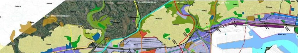
14 1950s


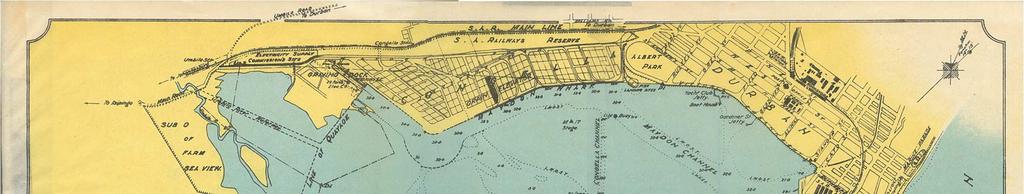
15 Why south Durban communities are fed up more than 100 year of oppression Indentured labour system to secure labour for sugar estates 1858 first arrivals Indian immigrants remain making a living in market gardening, fishing and hawking introduction of hut taxes in rural areas and the Natal poll tax in 1904, forcing unmarried black men to seek waged work in the city. Subject to regulations including worker registration fees, a 9pm curfew, designated residential barracks and strict penal system for any disorderly conduct. prior to 1914 reclamation and construction of the Maydon Wharf, followed by the Congella industrial estate.

16 Why south Durban communities are fed up more than 100 year of oppression 1930 Borough Boundaries Commission expanded the municipal boundaries to include the south Durban basin jurisdiction of town planning legislation to designate the area as industrial 1930s reclamation of land occurred on the eastern shores of the bay at Island View for fuel storage tanks, railway was constructed around the bay. Pressurised by industry, Council purchases 194 acres at Wentworth in 1925 and another 425 acres from the Bayhead south in 1931 for largescale industrial and worker housing developments Slums Act, slum clearance proceeded swiftly in the areas that had been identified for industry


17 1949 Durban Bay development report recommends that the railways, shipping and industry be integrated in south Durban and that reclamation, dredging and canalisation take place to provide usable industrial land. Group Areas Act (1951) - racial zoning scheme was adopted for Durban in 1952
, now")
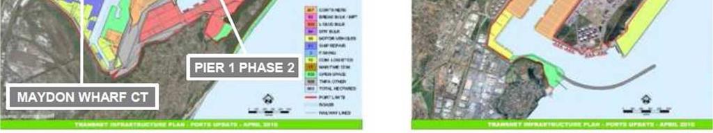
18 1948 industrial estate of Mobeni 1950 railway marshalling yards to the Bayhead changing the bay contours and reducing the water area of the bay by half. Merebank and Lamontville housing schemes planned to supply industry with labour 1952 draining & canalisation, diversion of Umlazi river for airport 1954 the Standard Vacuum Refinery (Stanvac), now the Engen refinery Attempts to rezone of Clairwood began in 1956 but met with resistance. Through covert Council acquired 148 acres of land in Clairwood in the 1960s, resulting in creeping industrialisation and the gradual degradation of the area. In 1960, BP and Shell together built the SAPREF refinery 1964 Anglo-American Corporation persuades Council to sell Merebank s open space alongside the Umlaas canal for a paper factory.
19 Clairwood The suburb of Clairwood has been an exceptional in resisting industrialisation. Settled by Indian immigrants in the 1920s, people worked hard to develop their own housing and cultural amenities. The Apartheid Council s attempts to rezone Clairwood as an industrial area, beginning in 1956, met with growing resistance. In the early 1960s, government began a more covert campaign to coerce people out of Clairwood through surreptitious land purchases and expropriation within 21 months many communities were destroyed and relocated as the first residents in the new Indian area of Chatsworth. Clairwood s population dwindled from an estimated in the early 1960s to a mere 6000 by In this way the Council acquired 148 acres of land in Clairwood for industry.
20 The South Durban Strategic Environmental Assessment (SEA) (1998). The Island View Hazardous Chemical Storage Complex, the harbour, the airport and Umlazi not studies Social impacts and community capacity building and decision-making key principles of Agenda 21 were not included. The SEA technical reports excluded the investigation of gaseous emissions such as Volatile Organic Carbon s (VOC s), Nitrous Oxides (NOx s) and heavy metal s as a result of heavy industrial development in South Durban. A spatial plan was not used in the process. The SO2 reduction plan by the community, the first of its kind in South Durban, was not accepted despite the SEA air pollution study finding that SO2 concentrations were 2-4 times higher than WHO standards. SEA accepted that the industrial character of south Durban would not change. Rather than stricter pollution control and enforcement, the consultants proposed the relocation of communities. National and provincial government had already announced intentions to develop a new international airport to the north of Durban. In the face of community opposition, the SEA favoured a combination of port and chemicals industry expansion into residential areas and at the airport site. The socio-economic impacts of these decisions were not studied.


21 South Durban Basin Spatial Development Framework December 2004 Currently broad strategic spatial development planning for: Southern planning region: Umlaas Canal south to the ethekwini boundary Draft plans submitted to Council. Public consultation at end of 2008 for final approval in December. Central planning region: Umlaas canal north to the Umgeni River mouth. Still at a rudimentary stage, but will take the South Durban Spatial Development Framework into account.

 Dilapidation contributes to a sense of neglect and hopelessness allocate to people that have lived in area longest affordable to the poor in the area.")
22 Housing & services Build what people need extended families, single mothers. Critical shortage use open land available Renovate and replace the the flats with properly designed housing to stem the tide of social problems (drug trafficking, shebeens, gangs and violence. ) Dilapidation contributes to a sense of neglect and hopelessness allocate to people that have lived in area longest affordable to the poor in the area. Create viable communities address flooding & waste management problems that bring pests Greater subsidies for basic services for the poor including water, electricity, schooling crosssubsidise from high users


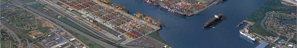
23 Over 70% of Durban s industry 300 industrial plants, (180 are smoke sta industries) Africa s largest industrial plants: the En and SAPREF (Shell and BP) oil refineries Island View chemical tank farm, the Mond paper mill and the AECI chemical At least people impacted


24


25


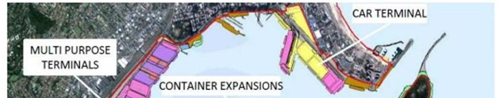
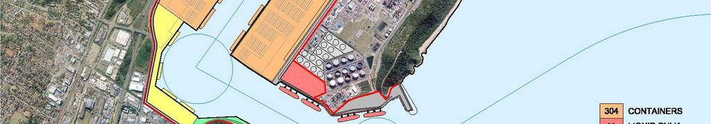
26 Containers = Imports TRANSNET projections show at a growth rate of 8% that a capacity of only 12 mill TEUs by 2040 Current: 2.7 mill TEUs (this year 1.56?) Planning for 20.2 mill TEUs 8 x the containers = pollution, trucks, social ills, port creep KZN Provincial Planning Commission gateway to Africa and the world 60% imports to Gauteng


27 R250 bill for Port expansion alone Claim jobs??? [R1.9 million/job created]


28 3% of mangrove remain 14% of the tidal flats remain. 30 species of fish % sand prawns critical breeding ground for reef associated and migratory marine fish. 132 species of birds are found here and 62 species of endangered, migratory birds rest and feed here. (9 species are already extinct.)
29


30


31 Umgeni 1987


32
Queensland Coastal Plan. Presented by John Lane Director Environment Planning
 Queensland Coastal Plan Presented by John Lane Director Environment Planning Queensland Coastal Plan - Status Released 7 April 2011, but NOT YET IN EFFECT Formatting & operational amendments required Yet
Hackney A Place for Everyone
 October 2016 Introducing Hackney A Place for Everyone Local Plan 2033 (LP33) A New Local Plan For Hackney What is the Local Plan 2033? The Local Plan will set out a vision for what Hackney will be like
Gibsons Foreshore & Seawalk Improvements
 Gibsons Foreshore & Seawalk Improvements Open House (5:00-7:00 pm) Town of Gibsons October 6, 2016 Town of Gibsons Foreshore & Seawalk Improvements 1 Session 3: Open House (Charrette Participants, Designers,
KANPUR 5 LAND USE Final Report: Kanpur City Development Plan Under JNNURM
 5 LAND USE The process of planned development for Kanpur city was started way back in 1943 when Kanpur Development Board has prepared the first development plan. With the change in socio-economic situation
Tāhuhu whakaruruhau ā-taone The sheltering ridge pole
 B2. Tāhuhu whakaruruhau ā-taone - Urban growth and form B2.1. Issues Tāhuhu whakaruruhau ā-taone The sheltering ridge pole Auckland s growing population increases demand for housing, employment, business,
To what extent do you agree or disagree with the four options?
 Issues and options questions The easiest and most effective way to respond to the consultation is by using our online consultation portal www.spelthorne.gov.uk/localplan However you can also email us at
SOUTH CAMBRIDGESHIRE DISTRICT COUNCIL. REPORT TO: Planning Committee 1 April 2015 Planning and New Communities Director
 SOUTH CAMBRIDGESHIRE DISTRICT COUNCIL REPORT TO: Planning Committee 1 April 2015 AUTHOR/S: Planning and New Communities Director Application Number: Parish(es): Proposal: Site address: Applicant(s): Recommendation:
SHORELINE, FLOOD AND COASTAL DEFENCE MANAGEMENT PLANS
 These plans may provide opportunities as well as concern for recreational boating. They are currently being revised and consulted on. This document explains how we can engage in the process. Shoreline,
EIA process in Malaysia. Approaches and Strategies. Way Forward
 PUBLIC PARTICIPATION APPROACHES AND STRATEGIES UNDER THE EIA PROCESS IN MALAYSIA By Norhayati Mohamad Yusof Principal Assistant Director Department of Environment Malaysia AECEN REGIONAL WORKSHOP Strengthening
TABLE OF CONTENTS PAGE
 1989 BROWARD COUNTY LAND USE PLAN Original adoption March 1, 1989 Text amendments adopted as of March 10, 2015, are incorporated herein. BROWARD COUNTY BOARD OF COUNTY COMMISSIONERS BROWARD COUNTY PLANNING
B - Coalfield River Corridor Landscape Character Type
 B - Coalfield River Corridor Landscape Character Type Landscape Character Type - Coalfield River Corridor The Coalfield River Corridors Landscape Character Type is located in the two converging valleys
PSRC REVIEW REPORT & CERTIFICATION RECOMMENDATION
 PSRC REVIEW REPORT & CERTIFICATION RECOMMENDATION KITSAP COUNTY COUNTYWIDE PLANNING POLICIES July 2, 2012 BACKGROUND A major emphasis of the Washington State Growth Management Act (GMA) is the need to
Draft Submission of Chilcompton Parish Council to Mendip Local Plan
 Draft Submission of Chilcompton Parish Council to Mendip Local Plan Note: This is a draft for consultation. The Parish Council urges all villagers and other stakeholders to send comments to: parishclerk@chilcompton.org.
Draft Eastern District Plan
 Draft Eastern District Plan Submission_id: 31238 Date of Lodgment: 13 Dec 2017 Origin of Submission: Online Organisation name: Turrulla Gardens Pty Ltd C/- Mecone Organisation type: Industry First name:
The Jigsaw: Legal Instruments for Biodiversity Planning in South Africa
 The Jigsaw: Legal Instruments for Biodiversity Planning in South Africa Annual Conference, Environmental Law Association AUGUST 2012 Dr. Marie Parramon-Gurney Head of Programmes: Sustainability and Development
Parish of Repton NEIGHBOURHOOD DEVELOPMENT PLAN
 Parish of Repton NEIGHBOURHOOD DEVELOPMENT PLAN BASIC CONDITIONS STATEMENT December 2018 CEF 4 Legal Requirements This statement has been produced by the NDP Working Group on behalf of Repton Parish Council
Environmental Impact Assessment
 Environmental Impact Assessment Environmental impact assessment (EIA) is the process of systematically drawing together an assessment of the likely significant environmental effects of a development project.
Stephen Berrisford Planning law and policy consultant Concise CV
 Stephen Berrisford Planning law and policy consultant Concise CV Areas of expertise Qualified lawyer & urban planner Law & policy reform Strategic advice and planning Project management Sectoral experience
Village of Fair Haven Goals & Objectives
 Village of Fair Haven Goals & Objectives 1 Natural Environmental Quality & Aesthetics Embrace policies and programs that preserve and enhance the Village s natural resources, environment, water quality,
CHAPTER Committee Substitute for Senate Bill No. 1472
 CHAPTER 2007-99 Committee Substitute for Senate Bill No. 1472 An act relating to beaches and shores; amending s. 161.021, F.S.; amending a definition; amending s. 161.085, F.S.; restricting the use of
GREEN BELTS, GREEN WEDGES OR DISPUTED GROUND
 GREEN BELTS, GREEN WEDGES OR DISPUTED GROUND John Ginivan Department of Planning and Community Development State Government of Victoria Melbourne Australia Greenbelts: Local Solutions for Global Challenges
Sustainability Statement. Whitby Business Park Area Action Plan
 Sustainability Statement Whitby Business Park Area Action Plan November 2014 Contents Page 1. Introduction 1 2. Scoping 3 3. Sustainability Appraisal of Options 6 4. Assessment of Draft Area Action Plan
Wallingford Neighbourhood Plan
 Wallingford Neighbourhood Plan Introduction What is neighbourhood planning? Neighbourhood planning was introduced by the Localism Act 2011 to give local people more influence over how development comes
Plan Modification to Chapter B2 of the Auckland Unitary Plan(AUP) Operative in part (15 November 2016)
 Operative in part (15 November 2016)") UNITARY PLAN UPDATE REQUEST MEMORANDUM TO FROM Phill Reid Linley Wilkinson DATE 25 September 2018 SUBJECT Plan Modification to Chapter B2 of the Auckland Unitary Plan(AUP) Operative in part (15 November
UNITARY PLAN UPDATE REQUEST MEMORANDUM TO FROM Phill Reid Linley Wilkinson DATE 25 September 2018 SUBJECT Plan Modification to Chapter B2 of the Auckland Unitary Plan(AUP) Operative in part (15 November
Master Plan for Preservation and Scenic Conservation (1995)
") 3.2 Master Plan for Preservation and Scenic Conservation (1995) The Master Plan for Preservation and Scenic Conservation was developed under the direction of the Guilford Preservation Alliance in the 1980s
3.2 Master Plan for Preservation and Scenic Conservation (1995) The Master Plan for Preservation and Scenic Conservation was developed under the direction of the Guilford Preservation Alliance in the 1980s
Proposals for the regeneration of Standard Quay, Faversham, Kent
 Proposals for the regeneration of Standard Quay, Faversham, Kent The purpose of this information is to explain the progress in regenerating Standard Quay and to outline proposals with indicative timescales
WELCOME. Land North of STEVENAGE. We would like to thank you for attending our public exhibition today.
 WELCOME We would like to thank you for attending our public exhibition today. The purpose of this event is to share our proposals and hear your thoughts on our ideas. Members of the project team are on
DEVELOPMENT IN NATAL N ~ TRANSVAAL " NGWANE. free STATE RICHARDS BAY. CAPE PROVI NeE. 50 o SO 100 I. Growth Centres c;:r) Growth Points
 Growth Points") DEVELOPMENT IN NATAL TRANSVAAL " NGWANE. \ free STATE RICHARDS BAY ~ N ~ Growth Centres c;:r) Growth Points Development Axis ~ CAPE PROVI NeE 50 o SO 100 I! Kilometres Natalia 3 (1973) Copyright Natal
DEVELOPMENT IN NATAL TRANSVAAL " NGWANE. \ free STATE RICHARDS BAY ~ N ~ Growth Centres c;:r) Growth Points Development Axis ~ CAPE PROVI NeE 50 o SO 100 I! Kilometres Natalia 3 (1973) Copyright Natal
Northern Territory Compact Urban Growth Policy
 Northern Territory Compact Urban Growth Policy A Reference Policy Document to clause 2.7 (Reference to Policy) of the NT Planning Scheme May 2015 Table of Contents 1 Policy Setting... 3 1.1 Context for
Dauphin Island s East End Beach and Barrier Island Restoration Project. April 16, :00 PM Dauphin Island Sea Lab, Shelby Hall
 Dauphin Island s East End Beach and Barrier Island Restoration Project Town of Dauphin Island, Alabama April 16, 2015 6:00 PM Dauphin Island Sea Lab, Shelby Hall Team Introduction South Coast Engineers
Mid Coquetdale Neighbourhood Plan - Vision and Objectives Consultation
 Neighbourhood Planning came into force in 2011, through the Localism Bill. It gives us a unique opportunity to produce our own Neighbourhood Development Plan for our own area. Rothbury Parish Council,
2015/1020 Mr Edward Cockburn Caravan storage on hardcore base (Retrospective) Ranah Stones, Whams Road, Hazlehead, Sheffield, S36 4HT
 Ranah Stones, Whams Road, Hazlehead, Sheffield, S36 4HT") 2015/1020 Mr Edward Cockburn Caravan storage on hardcore base (Retrospective) Ranah Stones, Whams Road, Hazlehead, Sheffield, S36 4HT Dunford Parish Council have not commented Councillor Andrew Millner
2015/1020 Mr Edward Cockburn Caravan storage on hardcore base (Retrospective) Ranah Stones, Whams Road, Hazlehead, Sheffield, S36 4HT Dunford Parish Council have not commented Councillor Andrew Millner
WELCOME GYPSY LANE. Wider Site Location plan. Proposals for the development of LAND OFF FOXLYDIATE LANE WEBHEATH. Proposals for the development of
 WELCOME The developers are preparing an outline planning application for a residential led development and need the community s views in order to develop the proposals further WHAT IS PROPOSED? A high
WELCOME. Thanks for visiting Hadley Property Group s exhibition on its initial plans to redevelop land at Bath Road in Totterdown.
 WELCOME Thanks for visiting Hadley Property Group s exhibition on its initial plans to redevelop land at Bath Road in Totterdown. This exhibition is to inform you about our plans to transform the disused
ELLIOTT HEADS STRUCTURE PLAN
 ELLIOTT HEADS STRUCTURE PLAN BACKGROUND This report has been prepared to provide an overview of the land that has been included in the Urban Footprint within the Wide Bay Burnett Regional Plan, September
City Center Neighborhood Plan
 [1] City Center Neighborhood Plan As adopted by Ordinance No. 2014-09-049 and amended by Ordinance Nos. Formerly CBD Neighborhood as adopted by Ordinance No. 8868 and amended by Ordinance Nos. 8946, 9693,
Official Plan Review
 Official Plan Review Summary Report - The Built Environment August 2014 Part 1: Introduction Planning for a healthy, prosperous and sustainable community is an important goal for our municipality. From
CITY COUNCIL AGENDA REPORT
 CITY COUNCIL AGENDA REPORT Subject: COUNCIL MOTION LRT ALIGNMENT REMOVAL FROM THE TRANSPORTATION MASTER PLAN On February 10, 2016 Councillor Hughes provided notice in accordance with Section 23 of Procedure
Great Easton Neighbourhood Plan Statement of Basic Conditions
 Great Easton Neighbourhood Plan 2017-2031 Statement of Basic Conditions OCTOBER 2016 GREAT EASTON PARISH COUNCIL Contents 1.0 Introduction....Page 2 2.0 Summary of Submission Documents and Supporting Evidence..
About 10% of the Borough's population lives in the seven rural parishes. Population figures from the 1991 census are given below:-
 8. THE DISTRICT VILLAGES 8.1 Population About 10% of the Borough's population lives in the seven rural parishes. Population figures from the 1991 census are given below:- Village No. of Persons Cottingham
14.5 HOPEFIELD: (REFER PLAN 39 AND PLAN 40)
") URBAN DYNAMICS WESTERN CAPE INC. 248 14.5 HOPEFIELD: (REFER PLAN 39 AND PLAN 40) FIGURE 83: LOCALITY - HOPEFIELD Within the context of the Saldanha Bay Municipal area, Hopefield, an historical agricultural
URBAN DYNAMICS WESTERN CAPE INC. 248 14.5 HOPEFIELD: (REFER PLAN 39 AND PLAN 40) FIGURE 83: LOCALITY - HOPEFIELD Within the context of the Saldanha Bay Municipal area, Hopefield, an historical agricultural
Ashbridges Bay Erosion and Sediment Control Project
 Ashbridges Bay Erosion and Sediment Control Project Project Brief Overview Toronto and Region Conservation Authority, in partnership with the City of Toronto, intends to carry out remedial erosion control
Proposed Variation to the Midleton Town Development Plan 2013
 Volume 1 Proposed Variation to the Midleton Town Development Plan 2013 Vacant Site Levy-Residential and Regeneration Areas Inclusion of new text and objective in relation to the Vacant Site Levy and Regeneration
Indonesia: Towards Habitat III and the New Urban Agenda
 MINISTRY OF PUBLIC WORKS AND HOUSING REPUBLIC OF INDONESIA Indonesia: Towards Habitat III and the New Urban Agenda Bangkok, 27-28 January 2016 Habitat Indonesia National Secretariat Outline Towards Habitat
River Basin Management Plans & Spatial Planning in N.Ireland. A land use planner s perspective
 River Basin Management Plans & Spatial Planning in N.Ireland A land use planner s perspective Key issues relating to river basin management and land use planning 1. Environmental Base Landscapes Habitats
CHAPTER 4: CONTEXTUALISING THE PROPOSED PROJECT ENVIRONMENT WITHIN THE NATIONAL AND LOCAL
 : CONTEXTUALISING THE PROPOSED PROJECT WITHIN THE NATIONAL AND LOCAL ENVIRONMENT CONTENTS 4. CONTEXTUALISING THE PROPOSED PROJECT WITHIN THE NATIONAL AND LOCAL ENVIRONMENT 4-1 4.1 Introduction to the Coega
Horwood Map of London, Westminster & Southwark First edition
 Barratt London is developing plans in tandem with Southwark Council and TfL to transform the southern end of Blackfriars Road. The residential-led, mixed-use scheme will deliver new private and affordable
RECREATION AND OPEN SPACE ELEMENT GOALS, OBJECTIVES, AND POLICIES
 RECREATION AND OPEN SPACE ELEMENT GOALS, OBJECTIVES, AND POLICIES Goal 7 To provide park facilities, recreation programs, and open space resources that are safe, adequate, and accessible to all City residents,
Workshop on Area-based Management and Regional Cooperation for the Implementation of Ocean-related Sustainable Development Goals
 Workshop on Area-based Management and Regional Cooperation for the Implementation of Ocean-related Sustainable Development Goals UN Environment and European Commission 9-10 February 2017, Brussels Healthy
Iran s Efforts for Progressive of Environmental Impact Assessment In a Transboundry Context
 United Nation Economic Commission For Europe Eighth Meeting of the Working Group on EIA Convention (27-29 April 2005) Geneva- Switzerland Country Report on Iran s Efforts for Progressive of Environmental
CURRICULUM VITAE MAGNUS VAN ROOYEN
 CURRICULUM VITAE MAGNUS VAN ROOYEN NAME OF FIRM JG AFRIKA (PTY) LTD NAME OF PERSON MAGNUS VAN ROOYEN NATIONALITY SOUTH AFRICAN DATE OF BIRTH 1976-09-04 CONTACT DETAILS 0842492365 PROFESSION ENVIRONMENTAL
Attention: Interested and Affected Party (I&AP) Commenting Period: 22 November January 2018 GNEC Code: 20327
 Commenting Period: 22 November January 2018 GNEC Code: 20327") 22 November 2017 Attention: Interested and Affected Party (I&AP) Commenting Period: 22 November 2017 15 January 2018 GNEC Code: 20327 Dear Interested and Affected Party INFORMING START OF 30 DAY PUBLIC
22 November 2017 Attention: Interested and Affected Party (I&AP) Commenting Period: 22 November 2017 15 January 2018 GNEC Code: 20327 Dear Interested and Affected Party INFORMING START OF 30 DAY PUBLIC
Richard Lemon Spatial Project Manager. Biodiversity and Green Infrastructure
 Richard Lemon Spatial Project Manager Biodiversity and Green Infrastructure A key concept: Multifunctionality Combining different functions on the same piece of land multi-functional green space, new
STATEMENT OF OBJECTION TO THE PROPOSED DEVELOPMENT OF LAND AT CHURCH CLIFF DRIVE FILEY
 STATEMENT OF OBJECTION TO THE PROPOSED DEVELOPMENT OF LAND AT CHURCH CLIFF DRIVE FILEY You will be aware that Scarborough borough council have adopted a new local plan that includes land at Church Cliff
1.0 INTRODUCTION. Brantham Industrial Area Regeneration - Factory Lane - Brantham
 1.0 INTRODUCTION Welcome to this exhibition of our proposals for the regeneration of the Brantham Industrial Area located off Factory Lane in Brantham. This presentation will give you an opportunity to
A Growing Community Rural Settlement Areas
 Town of Huntsville Official Plan Review - POLICY BACKGROUND PAPER A Growing Community Rural Settlement Areas BACKGROUND: In addition to the fully municipally-serviced Urban Settlement Area and the Hidden
Barking Riverside Gateways Housing Zone. Development Opportunity for 3,000 homes & modern commercial space
 Barking Riverside Gateways Housing Zone Development Opportunity for 3,000 homes & modern commercial space Executive Summary Barking Riverside is one of London s largest housing development sites with
INCREMENTAL CHANGE AREA REVIEW March 2015 Page 1
 INCREMENTAL CHANGE AREA REVIEW March 2015 Page 1 Table of Contents Introduction... 3 Background to Review... 3 Comparison of the Schedules to the General Residential Zone... 7 Methodology... 7 Policy Context...
Mollers Lane, Leopold, Victoria Significant Landscape Overlay Re-assessment
 XURBAN Mollers Lane, Leopold, Victoria Significant Landscape Overlay Re-assessment For: TGM Group November 2016 Final Mollers Lane, Leopold, Victoria Significant Landscape Overlay Re-assessment Client
Agenda. 3. Outstanding Items. How it would work (DRP) Urban Design Guidelines language in Sector Plan (Concepts) vs. Guidelines Document (Detail)
 Urban Design Guidelines language in Sector Plan (Concepts) vs. Guidelines Document (Detail)") Work Session #14 Planning Board June 9, 2016 Agenda 1. Big Picture Items to Confirm Upfront 2. Detailed Topics for Conversation a) Park Impact Payment b) Priority Sending Sites - Additional Incentives
Work Session #14 Planning Board June 9, 2016 Agenda 1. Big Picture Items to Confirm Upfront 2. Detailed Topics for Conversation a) Park Impact Payment b) Priority Sending Sites - Additional Incentives
Chapter 9. Historic Preservation Element
 Chapter 9. Historic Preservation Element Introduction This Historic Preservation Element of the Comprehensive Plan coordinates and directs the protection of sites, objects, and buildings central to the
Linden Homes Proposals for the Ridgewood Centre, Old Bisley Road, Frimley
 Linden Homes Welcome Welcome to our public exhibition. Today we are displaying draft proposals for a high quality residential redevelopment of land off Old Bisley Road, currently known as the Ridgewood
The Commissioner of Engineering and Public Works, the Director of Public Works and the Director of Development / Transportation Engineering recommend:
 COMMITTEE OF THE WHOLE JUNE 16, 2008 WATER FOUNTAINS AND AERATION DEVICES IN STORM WATER MANAGEMENT FACILITIES Recommendations The Commissioner of Engineering and Public Works, the Director of Public Works
1. The EIA System in Japan
 Index 1. The EIA System in Japan 2. The Environmental Impact Assessment Law (1) Objective (2) Revision of the Environmental Impact Assessment Law (3) Projects subject to EIA (4) Who implements EIA? (5)
Local Development Scheme
 Local Development Scheme 2012 2016 The Local Development Scheme (LDS) is a project plan that outlines how and when the Authority will update its planning policies and other associated documents. It ensures
Wiltshire Council s Core Strategy
 HAWKE Wiltshire Council s Core Strategy 2006-2026 As part of its Core Strategy (master plan), Wiltshire Council needs to find areas to develop for employment purposes up to 2026. This land was first suggested
TICKET INFORMATION UTILIZATION BYLAW
 TICKET INFORMATION UTILIZATION BYLAW CONSOLIDATED THIS IS A CONSOLIDATION, FOR REFERENCE PURPOSES, OF: Greater Vancouver Regional District Ticket Information Utilization Bylaw No. 1050, 2006 (Adopted July
Canyon Lake Master Plan Revision Public Information Meeting March 18, 2016
 Canyon Lake Master Plan Revision Public Information Meeting March 18, 2016 Marcus Schimank Canyon Lake Manager Capital Regional Office U.S. Army Corps of Engineers Fort Worth District US Army Corps of
CHAPTER ONE INTRODUCTION
 1.0 Introduction Bellingham s central waterfront is in a state of transition from its long history as an active industrial site to a new mixed-use neighborhood. Over the past several years, the Port of
South of Eastern Strategic Direction Status Update
 STAFF REPORT ACTION REQUIRED South of Eastern Strategic Direction Status Update Date: July 10, 2014 To: From: Planning and Growth Management Committee Chief Planner and Executive Director, City Planning
TOWN OF INNISFIL SPECIAL COUNCIL AGENDA OUR JOBS INNISFIL HEIGHTS WORKSHOP WEDNESDAY JANUARY 20, :30 P.M.
 January 13, 2016 TOWN OF INNISFIL SPECIAL COUNCIL AGENDA INNISFIL HEIGHTS WORKSHOP WEDNESDAY JANUARY 20, 2016 5:30 P.M. PLEASE REMEMBER TO TURN OFF CELL PHONES 1. OPENING OF MEETING BY THE MAYOR Opening
Joint Study Session of the Sutter County. March 2, 2009
 Joint Study Session of the Sutter County Board of Supervisors and Planning Commission March 2, 2009 CURRENT APPLICATION General Plan Amendment Specific Plan Specific Plan Appendices Utility Plans Transit/AQ
Regional Context Statement
 Regional Context Statement REGIONAL CONTEXT STATEMENT 3. REGIONAL CONTEXT STATEMENT In 1995, the Provincial Government passed into law the Growth Strategies Act. The purpose of this provincial initiative
Perth and Kinross Council Development Management Committee 8 June Pre-Application Report by Development Quality Manager
 Perth and Kinross Council Development Management Committee 8 June 2016 5(3)(i) 16/259 Pre-Application Report by Development Quality Manager Residential development at St Martins Road, Land 120 metres West
B R I E F A p p e n d i x A : F i g u r e s
 HALTON MUNICIPALITIES BRIEF: APPENDIX A 1 B R I E F A p p e n d i x A : F i g u r e s 2 0 1 6 Halton Municipalities Regional Municipality of Halton Corporation of the City of Burlington Corporation of
Western City District What we heard
 What we heard Vision to 2056 and Priorities Governance and implementation Infrastructure and funding The protection of the natural landscape including biodiversity and the Metropolitan Rural Area for food
City of Rockingham. Local Management Practices, Costs and Strategic Coastal Planning
 City of Rockingham Local Management Practices, Costs and Strategic Coastal Planning Decision Making Process Considerations Climate Change Response Action Plan Ongoing observations/major Storm events Ongoing
A. WHAT IS A GENERAL PLAN?
 I. Introduction A. WHAT IS A GENERAL PLAN? A general plan is the planning guideline for the future of a city. It contains goals and policies which regulate urban development, the protection of the natural
Pinellas County Greenways
 Pinellas County Greenways USING GREENWAYS TO LINK OPEN SPACES The Florida Greenways Commission has defined a greenway as...a corridor of protected open space that is managed for conservation and/or recreation.
University Park, Worcester Non Technical Summary December 2011
 University Park, Worcester Non Technical Summary December 2011 Introduction UW Wrenbridge LLP, a Joint Venture Company of the University of Worcester and Wrenbridge Land Ltd (the Applicants ) intend to
Natural Resource Adaptation Action Area Addressing Sea Level Rise in Estuarine Ecosystems TO: TOWN OF YANKEETOWN MAY
 Natural Resource Adaptation Action Area Addressing Sea Level Rise in Estuarine Ecosystems TO: TOWN OF YANKEETOWN MAY 6 2013 University of Florida Conservation Clinic Vivek Babbar, Student Associate, J.D.
Agenda 21. Arthur Lyon Dahl. Contents
 Agenda 21 61 Arthur Lyon Dahl Contents Definition... 528 What Is Agenda 21?... 528 Agenda 21 and Pollution... 528 Climate Change in Agenda 21... 529 Agenda 21 and Global Change... 529 Conclusions... 530
11 APPEAL BY LEBOVIC ENTERPRISES INC. AND REVLIS LTD. TO OFFICIAL PLAN AMENDMENT D , TOWN OF AURORA
 11 APPEAL BY LEBOVIC ENTERPRISES INC. AND REVLIS LTD. TO OFFICIAL PLAN AMENDMENT D09-09-03, TOWN OF AURORA The Planning and Economic Development Committee recommends the following: 1. The deputation by
Planning and Growth Management Committee. Chief Planner and Executive Director, City Planning Division. Pg12013 (File No NNY 34 OZ)
") 865 York Mills Road Official Plan Amendment Application Preliminary Report STAFF REPORT ACTION REQUIRED Date: February 28, 2012 To: From: Wards: Reference Number: Planning and Growth Management Committee
865 York Mills Road Official Plan Amendment Application Preliminary Report STAFF REPORT ACTION REQUIRED Date: February 28, 2012 To: From: Wards: Reference Number: Planning and Growth Management Committee
The Integrated Transport Plan: Non-motorised Transport in the City of Cape Town (1979) 1
 1") Integrating the Bicycle in Comprehensive Policies The Integrated Transport Plan: Non-motorised Transport in the City of Cape Town (1979) 1 The 1980-1985 Transport Plan for Cape Town Metropolitan Transport
Integrating the Bicycle in Comprehensive Policies The Integrated Transport Plan: Non-motorised Transport in the City of Cape Town (1979) 1 The 1980-1985 Transport Plan for Cape Town Metropolitan Transport
Natomas Joint Vision Open Space Plan
 Natomas Joint Vision Open Space Plan First Workshop series The City of Sacramento The County of Sacramento LAFCo ERA Economic Research Associates EIP Associates a Division of PBS & J Natomas Joint Vision
Planning and Public Consultation Process for the Preparation of a General Land Use Plan for South Port Kells TERMS OF REFERENCE
 APPENDIX "B" Planning and Public Consultation Process for the Preparation of a General Land Use Plan for South Port Kells TERMS OF REFERENCE PURPOSE South Port Kells is located in the northeastern quadrant
Rooley Moor Neighbourhood Development Plan
 Rooley Moor Neighbourhood Development Plan Strategic Environmental Assessment (SEA) and Habitats Regulations Assessment (HRA) Screening Report September 2018 1 Contents: 1. Introduction 3 2. Legislative
OUR AREA SECTION 02 I NEXT PAGE. 2.1 This section sets the scene in regard to the role of the Legacy Corporation and the baseline
 7 ADOPTED LOCAL PLAN SECTION 02 2.1 This section sets the scene in regard to the role of the Legacy Corporation and the baseline position of the Local Plan. It sets out the historical context and current
Welcome to our exhibition
 Welcome to our exhibition housing development A46 Wildmoor Alcester Road Canal Quarter A422 Town Centre housing development Warwickshire-based IM Properties, one of the UK s largest privately owned property
National Conservation Council AGENDA
 2017-05-03 NCC GM Agenda v1 National Conservation Council Special General Meeting (National Trust Meeting Room Dart Park, Wednesday 3 rd May 3:30pm- 5pm) AGENDA 1. Call to Order a. Attendees, Apologies,
PROPERTY OFFERING 546 Toll Gate Road Groton, CT 06340
 PROPERTY OFFERING 546 Toll Gate Road Groton, CT 06340 Table Of Contents PACKET OVERVIEW 1) Welcome to Groton 2) Property Detail 3) Exterior Photographic Highlights 4) Interior Photographic Highlights 5)
WELCOME. Welcome and thank you for visiting today.
 WELCOME Welcome and thank you for visiting today. Bellway Homes Ltd (Yorkshire) are preparing a reserved matters planning application for a residential development of 293 homes at land North of Yew Tree
COMMERCIAL. 29 years experience PROJECTS
 COMMERCIAL 29 years experience PROJECTS Commercial Projects Our projects division is run by a team of specialised personnel, with exceptional product knowledge who understand the process of a building
Baby Point Heritage Conservation District Study. Kick-off Community Meeting March 27, 2017 Humbercrest United Church
 Baby Point Heritage Conservation District Study Kick-off Community Meeting March 27, 2017 Humbercrest United Church Agenda 7:00 Welcome 7:10 HCD Study Overview and Process 8:00 Interactive Discussion /
Soho Loop, Dudley Road
 01 Early artists impression of the Soho Loop site from the early stages of the design process Welcome Soho Loop Limited intend to submit new planning proposals for the derelict Soho Loop site on Dudley
Welcome. Site/11/04. Site/11/03. Proposed Site. 11,400 new homes needed in east Cambs
 Welcome Welcome to our consultation on our proposals for new homes on land north east of Soham Road, Fordham. Members of the project team are available to answer any questions you have and listen to feedback.
CHAPTER 12 IMPLEMENTATION
 CHAPTER 12 IMPLEMENTATION The 2010 Town of Denton Comprehensive Plan is intended to capture a vision of the future of Denton. As such, it provides a basis for a wide variety of public and private actions
Jonathan Sharpe, NL EHJV Program Manager
 Wildlife/Habitat Stewardship in Newfoundland and Labrador: The Stewardship Association of Municipalities i Inc. Wilson Hoffe SAM President Wilson Hoffe, SAM President Jonathan Sharpe, NL EHJV Program Manager
Part I: Setting the Scene
 Part I: Setting the Scene B TABLE OF CONTENTS B.1 International imperatives... B.2 B.3 South African settlements - the policy environment... A vision for South African settlements... B A VISION FOR HUMAN