CHAPTER ONE INTRODUCTION
|
|
|
- Lesley Whitehead
- 5 years ago
- Views:
Transcription

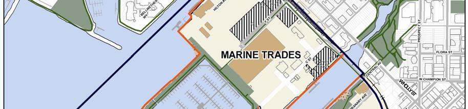
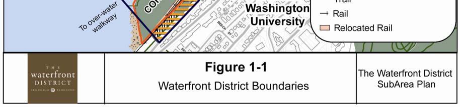
1 1.0 Introduction Bellingham s central waterfront is in a state of transition from its long history as an active industrial site to a new mixed-use neighborhood. Over the past several years, the Port of Bellingham and the City of Bellingham have joined together to create a vision and develop a clear path to transform this vacant brownsfield site into a thriving mixed-use urban neighborhood. In early 2005, the Port of Bellingham acquired approximately 137 acres of waterfront property and tidelands adjacent to Bellingham Bay. This property had been owned by the Georgia-Pacific Corporation, which operated a pulp and tissue mill on the site. This property, along with other Port, City and private properties, made up a project site, which was initially called New Whatcom, and later renamed the Waterfront District. The Sub- Area Plan boundary was expanded in 2012 to include the bluff along Boulevard and State Street to make the boundary contiguous with the Sehome and South Hill neighborhood boundaries and to delete several parcels which overlapped with the Old Town Urban Village Plan. See Figure 1-1 Sub-Area Boundary. CHAPTER ONE restore the health of the land and water, improve waterfront access, promote a healthy and dynamic waterfront economy, and reinforce the inherent qualities of the waterfront. The Waterfront District Sub-Area Plan represents a joint planning effort with the City of Bellingham involving residents, landowners, community stakeholders and resource agencies to create a long-term redevelopment opportunity for the Waterfront District. 1.2 Relationship to the 2006 Comprehensive Plan The 2006 City of Bellingham Comprehensive Plan establishes goals and policies to guide future decision-making and coordinate growth within the City over a 20-year planning period. The Comprehensive Plan serves as a guideline for designating land uses, infrastructure development and community services, and long-range implementation strategies. The Waterfront District falls within two urban villages defined in the Comprehensive Plan: the Central Waterfront District and the Central Business District (CBD) Core Village. Infill within urban villages is an essential element of the City growth strategy. 1.1 Purpose of the Sub-Area Plan The Sub-Area Plan s purpose is to provide a framework for future development of the 237 acre site known as the Waterfront District. The Waterfront District Sub- Area Plan includes a balance of environmental, economic and community objectives developed to Comprehensive Plan Policy FLU-18 requires a master plan to be prepared for each urban village to provide a framework for development. The Waterfront District Sub-Area Plan meets the criteria for a Master Plan as defined in the City Comprehensive Plan. Master or Sub-Area plans for urban villages must specify land uses and densities; street and utilities layout; lot arrangement; housing types; village square or plaza locations; streetscape amenities; relationship of the buildings to the street; parking structures or lots; protection of critical areas; pedestrian and bicycle facilities; and compatibility with surrounding areas. 3

2 The Waterfront District is located within the City of Bellingham CBD Neighborhood. When the CBD Neighborhood Plan was updated in 2008, the neighborhood plan incorporated sections of the Waterfront Futures Group Vision and Framework Plan pertaining to the City Center, which includes the Waterfront District. Concurrent with the adoption of the CBD Neighborhood Plan, the Waterfront District was rezoned to a new zoning category called Waterfront Mixed-Use. This new zoning designation becomes effective upon adoption of the Waterfront District Sub-Area Plan, which more clearly defines the intended uses and development patterns within the area. as an underutilized area and a vital link between the Central Business District, Old Town, and adjacent residential neighborhoods. Job opportunities, environmental restoration, and increased public access and recreational opportunities on the waterfront have been identified as priorities for the area. An extensive planning effort was conducted by the Waterfront Futures Group (WFG) in 2003/2004. The Port and City appointed this citizen-led task force to take a fresh and independent look at the future of the entire waterfront in response to the closure of Georgia- Pacific s (GP) pulp and tissue operations. The 1.3 The Planning Process Related Planning Processes Bellingham s City Center and Central Waterfront has been a focus of numerous planning efforts since the early 1990 s. Those plans include: Regional Urban Design Assistance Team Report (1992) Visions for Bellingham (1992) Bellingham Bay Demonstration Pilot (1996 present) Whatcom Creek Waterfront Action Program (1996) Downtown Development Workshop (1998) Bellingham Bay Comprehensive Strategy FEIS (2000) City Center Master Plan (2002) Community Forum on Growth Management (2004) Waterfront Futures Group (WFG) Vision and Framework Plan (2005) Bellingham Comprehensive Plan (2006) Central Business District Neighborhood Plan (2008) These planning efforts involved various forms of community input and involvement. Each process identified the Waterfront District WFG held 41 public meetings and had 26 guest forums and special events focusing on the future of the waterfront. The WFG completed the community visioning process by publishing the Waterfront Vision and Framework Plan which called for redevelopment of the city center waterfront into a mixed-use neighborhood that combines commercial, institutional, industrial, retail and residential uses, and that over time will provide many new job opportunities and a substantial amount of urban housing. The WFG vision was approved by City Council and the guiding principles and recommendations were used to update Bellingham s Comprehensive Plan and the CBD Neighborhood Plan in 2006 and 2008 respectively. 4

3 CHAPTER ONE 5

4 Public Investment After closure of the pulp mill in 2001, GP explored options to fund the required environmental clean-up to market the property for private development, but the cost of clean-up and the required infrastructure investment made it difficult to attract private investors. During this period, the Port studied the potential acquisition of the GP property to determine if public ownership was viable. The Port purchased the GP property in 2005 after extensive community outreach and partnership commitments from the City and the Washington State Department of Ecology to make the long-term public investments necessary to implement the community s vision on the central waterfront. The Port committed to pay for most of the environmental cleanup, to build marine infrastructure, and to dedicate land for parks, public space and rights of way. The City agreed to build new streets and utilities to serve the site, to develop waterfront parks and trails, and to create a regulatory environment that would attract private investment. The Department of Ecology pledged grant support for environmental cleanup costs. Since acquiring the GP property, the Port and City have secured significant state and federal grant support and have started to spend money on environmental cleanup, habitat restoration and infrastructure design. These public investments are intended to attract substantial private sector investment and generate long-term positive impacts for the community. The Waterfront District Planning Process The Port and City launched a public planning process to develop a Sub-Area Plan for the Waterfront District shortly after acquiring the GP property. To ensure this plan was consistent with the community vision, the Port and City appointed the Waterfront Advisory Group (WAG) to integrate recommendations of the WFG into plans, projects and regulations. From , this citizen-led task force held regular public meetings to gather public input and ensure public awareness and participation in waterfront planning. The Port and City started development of the Sub-Area Plan by inviting neighbors, business owners and anticipated stakeholders to a series of eight workshops and community meetings during 2005 and 2006 to help turn the WFG vision into a Draft Framework Plan, which could be tested under the State Environmental Policy Act (SEPA). During these meetings and workshops, the community evaluated a range of design alternatives that illustrated how infrastructure, development, public parks and trails, and new habitat might take shape on the waterfront. 6

5 The Draft Environmental Impact Statement (DEIS) identified a traffic congestion problem with the proposed street layout in the Draft Framework Plan and evaluated alternate street layouts, densities and other mitigating measures to address traffic, view corridors, historic and cultural resources, critical areas and a range of other important considerations. The Draft Framework Plan also provided an opportunity for the Port and City to assess the project economics. Additional public meetings and workshops were held during 2007 and 2008 to update the community, address specific issues raised by the SEPA analysis and by the public, and receive input to guide development of draft master plan concepts and regulations. During this process, the public provided input on the Waterfront District s character-defining features, view corridors and vistas, preferred land uses, building heights and design standards. The community discussed the role of Western Washington University (WWU) and its plans to create a campus on the waterfront, multimodal circulation, development character, environmental considerations, parks, trails, plazas, economic viability, block sizes, parking strategies, development phasing, historic and cultural resources, and sustainable strategies. A group of local architects volunteered to evaluate the planning concepts and provide recommendations and ideas that maintained the original WFG vision. The Port and City also hired an architectural firm to assess the potential for preservation and adaptive reuse of eleven industrial buildings and structures. This evaluation considered the condition of the historic resources, the cost of construction, market feasibility and compatibility with other planning objectives. CHAPTER ONE In addition to the public input received during the planning process, the Port and City received feedback and recommendations from the Waterfront Advisory Group, Western Washington University, Whatcom Transportation Authority, environmental resource agencies, regional and local developers and professional consultants. This Sub-Area Plan is the culmination of these public processes. 1.4 Context Natural and Historical Setting Bellingham s current waterfront is made up of land forms created by filling tidal flat areas over the past century. Before this filling occurred, these tide flats provided food and protection to young salmon as they left nearby rivers and adjusted to salt water in preparation for a journey out to sea. For thousands of years, ancestors of the present day Lummi Nation and Nooksack Indian Tribe relied upon catching the salmon passing the nearshore areas. The beaches and nearshore areas were used by these Native American tribes as seasonal encampments for fishing and shellfish harvesting. For the last 100 years or more, Bellingham s waterfront has served the regional economy as a thriving industrial area, transportation gateway and home to many maritime activities. In 1891, the Great Northern Railroad finished an overwater rail trestle across the mud flats on Bellingham s central waterfront allowing the 7

6 distribution of goods across a new, nationwide rail network. In the early 1900 s, the Whatcom Creek federal waterway was established and silt from the dredged waterway was used as fill along parts of the waterfront. In 1926, Ossian Anderson opened Bellingham s first pulp mill on the south side of the Whatcom Waterway creating a new economic opportunity for Whatcom County s extensive timber resources. In the years after, Pacific Coast Paper Mills and Puget Sound Pulp were founded and operated as major employers on the waterfront. Through the 1930 s and 40 s, the Bellingham waterfront saw major activity related to the pulp mill and the production of ethyl alcohol (a by-product from pulp mill waste). In the early 1960 s, Georgia-Pacific acquired the waterfront mill site. Operations continued through the following decades, discharging various waste products to adjacent waterways and upland properties. During this time, Bellingham s waterfront industries were largely unregulated and there was not a general awareness or understanding of the importance of environmental stewardship. built a 36-acre wastewater treatment lagoon on the north side of the Whatcom Waterway to treat process water. The GP mill adjusted to economic trends over the years, but in 2001 the pulping operation was permanently closed down. This signaled a slow decline that continued until Georgia-Pacific closed its Bellingham site permanently on December 21, The Waterfront District Today Today, the Waterfront District is bordered by Bellingham Bay to the west, CBD and Old Town to the east, the Lettered Streets and Columbia neighborhoods to the north, and Sehome and South Hill neighborhoods to the south. Present densities within the Waterfront District are low. There is no residential population and most of the property is vacant with pockets of contamination due to past industrial activities. The site is primarily paved and occupied by inactive industrial structures. Despite its prominent location between Bellingham Bay and downtown Bellingham, public pedestrian and vehicular access is limited and the only recreational use of the site occurs at the southwesterly end of Cornwall Avenue where a small pocket beach is located. Most of the shorelines are hardened with industrial wharfs, bulkheads, and non-engineered rip rap. Redevelopment of the Waterfront District is a once in a century opportunity intended to restore public access along the shoreline and convert the upland area closest to the Central Business District to a vibrant mixed-use extension of downtown Bellingham. Other portions of the site will be remediated and marketed for shipping, marine trades and light industrial uses to replace a portion of the jobs lost when the Georgia Pacific mill closed. In 1972, the United States passed the Clean Water Act ushering in a new era of pollution control. In response to the growing framework of environmental regulations, GP 8 8
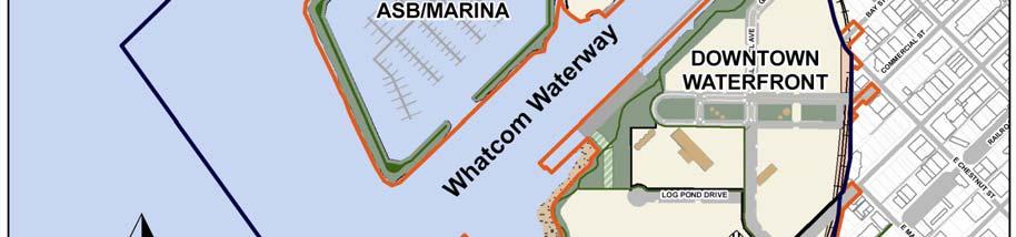
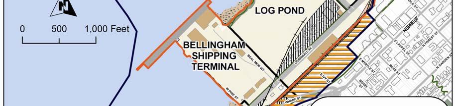
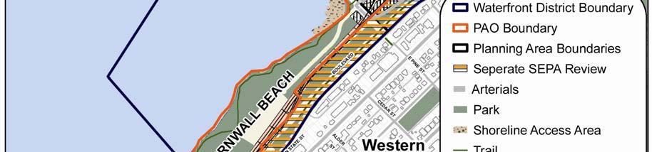
7 1.5 Redevelopment Potential The redevelopment of the Waterfront District as an urban neighborhood will help concentrate a significant amount of expected population growth within the existing city limits and reduce impacts on agricultural, forest and rural landscapes in the county. The 2006 Bellingham Comprehensive Plan projects a demand for 1,225 infill housing units in the Central Waterfront District Urban Center, and an additional 1,321 units in the Downtown Core Urban Center by the year The Waterfront District encompasses the majority of the vacant land within these two Urban Centers and redevelopment at urban density is an important element in the City s adopted infill strategy. There are 237 acres within the planning area of the Waterfront District, including the ASB lagoon, most of which is currently in public ownership by the Port, City and Washington State Department of Natural Resources. Over half of the project area will be retained for public open space and infrastructure, including 33 acres of new park land, 4 acres of existing public open space, 60 acres for streets, utilities and railroad rights-of-way, and 29 acres for a marina. The remaining 111 acres of Port, City and private property will be available for industrial use or redevelopment for residential, retail, commercial, and institutional use. CHAPTER ONE One of the key challenges for this planning effort was the definition of an appropriate goal for the level of development density within the Waterfront District. During initial planning discussions in 2005, the Port and City planning team identified the Fairhaven Historic District as a starting point for evaluating density options. The density of building in Fairhaven, if applied to the entire Waterfront District would result in approximately 6.0 million square feet of building floor space. This density assumption was used in the Draft Framework Plan published jointly by the City and Port in September, 2006, and was used as the medium density development alternative in the evaluation of a range of alternatives in the Environmental Impact Statement (EIS) for the proposal. A low-density alternative of 4.0 million square feet and a high-density alternative of 7.5 million square feet were also analyzed. Based on this analysis and public comment, the medium-range density of 6.0 million square feet of floor space was selected as the preferred alternative in the 2008 Supplemental Draft EIS. As the preferred alternative was further refined, five separate planning areas were defined, each of which has a different redevelopment character and density. The Downtown Waterfront Area is expected to accommodate a density somewhat higher than Fairhaven, while the Marine Trades, Shipping Terminal and Cornwall Beach Areas will be significantly less dense than Fairhaven. The Log Pond Area is proposed to remain in industrial use through the end of the planning period for the Sub-Area Plan. At full build-out, the Waterfront District is projected to have 5.3 million square feet of building capacity, with a mix of commercial, residential, office, institutional and industrial uses. 9
6 Utility Systems Utility System Policies 6.2 Implementation Strategies 7 Parks, Open Space and Trails 63
 Draft Sub-Area Plan 2012 Prepared by the Port of Bellingham and the City of Bellingham, with assistance from CollinsWoerman, the Waterfront Advisory Group and many other Whatcom County citizens and volunteers.
6 Utility Systems Utility System Policies 6.2 Implementation Strategies 7 Parks, Open Space and Trails 63
 Sub-Area Plan 2013 Prepared by the Port of Bellingham and the City of Bellingham, with assistance from CollinsWoerman, the Waterfront Advisory Group and many other Whatcom County citizens and volunteers.
Table of Contents Waterfront District Sub-Area Plan
 Table of Contents CHAPTER ONE INTRODUCTION...1 1.0 Introduction...1 1.1 Purpose of the Sub-Area Plan...1 1.2 Relationship to the 2016 Bellingham Comprehensive Plan...2 1.3 The Planning Process...2 Figure
Planning Commission March 14, Presented by: City of Bellingham Port of Bellingham
 Planning Commission March 14, 2013 Presented by: City of Bellingham Port of Bellingham 1 Agenda Waterfront District Background Waterfront District Proposal Overview Sub-area Plan Development Regulations
Coastal Smart Growth Approaches for Working Waterfront Preservation, Implementing Locally-Based Strategies and Solutions
 Coastal Smart Growth Approaches for Working Waterfront Preservation, Implementing Locally-Based Strategies and Solutions National Working Waterfronts Symposium March 26, 2013 Presented by: Lydia Bennett
City Center Neighborhood Plan
 [1] City Center Neighborhood Plan As adopted by Ordinance No. 2014-09-049 and amended by Ordinance Nos. Formerly CBD Neighborhood as adopted by Ordinance No. 8868 and amended by Ordinance Nos. 8946, 9693,
CITY OF BELLINGHAM PLANNING DEPARTMENT STAFF REPORT
 1 1 1 1 1 1 1 1 0 1 0 1 0 1 0 CITY OF BELLINGHAM PLANNING DEPARTMENT STAFF REPORT Agenda Topic: For: Staff Contact: I. Project Summary Review of the Waterfront District subarea plan and associated documents,
Waterfront Redevelopment. City Council Briefing May 15, 2006
 Waterfront Redevelopment City Council Briefing May 15, 2006 Topics Reason for this presentation Recap of recent waterfront events Marina/Park economic and feasibility evaluation Planned next steps Recap
C. Westerly Creek Village & The Montview Corridor
 C. Westerly Creek Village & The VISION Community Vision When the goals of the city are achieved Westerly Creek Village, a distinctive community defined by Montview Boulevard and Westerly Creek, is a strong
FEBRUARY 1, 2008 CONCEPT PLANNING SESSION #2
 CONCEPT PLANNING SESSION #2 MASTER PLAN CONCEPTS A & B Today the city does not spatially connect The THE COMMUNITY VISION NEW WHATCOM GUIDING PRINCIPLES AND IMPLEMENTATION STRATEIGIES The Waterfront Futures
A. WHAT IS A GENERAL PLAN?
 I. Introduction A. WHAT IS A GENERAL PLAN? A general plan is the planning guideline for the future of a city. It contains goals and policies which regulate urban development, the protection of the natural
Stephanie Bower, Architectural Illustration Preliminary Review Draft Sub-Area Plan 2010
 ephanie Bower, Architectural Illustration Preliminary Review Draft Sub- Plan 2010 A Port of Bellingham/City of Bellingham Partnership Project Prepared by the Port of Bellingham in cooperation with the
The Five Components of the McLoughlin Area Plan
 The Five Components of the McLoughlin Area Plan This documents contains the complete language of the five components of the McLoughlin Area Plan: The Vision Statement The Values The Guiding Principles
Town Center (part of the Comprehensive Plan)
") Town Center (part of the Comprehensive Plan) Mercer Island Town Center Looking North (2014) In 1994, a year-long process culminated in a set of design guidelines and code requirements for the Town Center
Town Center (part of the Comprehensive Plan) Mercer Island Town Center Looking North (2014) In 1994, a year-long process culminated in a set of design guidelines and code requirements for the Town Center
Keyport. Vision for Keyport
 Keyport Vision for Keyport Keyport is a rural, historic waterfront village bounded and limited in size by its natural borders of water and the Naval Undersea Warfare Center. The community consists primarily
PSRC REVIEW REPORT & CERTIFICATION RECOMMENDATION
 PSRC REVIEW REPORT & CERTIFICATION RECOMMENDATION KITSAP COUNTY COUNTYWIDE PLANNING POLICIES July 2, 2012 BACKGROUND A major emphasis of the Washington State Growth Management Act (GMA) is the need to
2040 LUP is a part of the Comprehensive Plan and carries the same legal authority. Economic Challenges
 1.1. Guiding Anchorage s Growth Where will new residents settle over the next two decades? Where will people work, shop, and play? Will there be enough room to grow? How will Anchorage look? Will growth
Growth Management Planning in the Central Puget Sound Region. Today s Presentation. Puget Sound Region. New Partners for Smart Growth
 Growth Management Planning in the Central Puget Sound Region New Partners for Smart Growth Denver, CO January 2006 Today s Presentation Regional growth management in central Puget Sound, WA Regional geographies
Concord Community Reuse Project Goals and Guiding Principles. Overarching Goals (OG)
") Concord Community Reuse Project Goals and Guiding Principles Overarching Goals (OG) No priority is implied by the order of presentation of the goals and guiding principles. Overarching goals for the Concord
Concord Community Reuse Project Goals and Guiding Principles Overarching Goals (OG) No priority is implied by the order of presentation of the goals and guiding principles. Overarching goals for the Concord
Sustainable Waterfront Redevelopment Case Study: Seattle, Washington. By Nicole Faghin, LEED AP
 Sustainable Waterfront Redevelopment Case Study: Seattle, Washington By Nicole Faghin, LEED AP CONTENTS Introduction to AECOM Introduction to Puget Sound Sustainable Redevelopment of Seattle s Waterfront
CITY OF COLWICH COMPREHENSIVE PLAN LAND USE LAND USE 1
 LAND USE LAND USE 1 WHAT YOU WILL FIND IN THIS CHAPTER: Discussion of today s conditions and tomorrow s projections Discussion of challenges and opportunities Discussion of the environmental quality goals,
ARISE: The Rock Renaissance Area Redevelopment & Implementation Strategy
 2014 Professional Awards 1 ARISE: The Rock Renaissance Area Redevelopment & Implementation Strategy Janesville, WI Completed December 2014 Analysis & Planning Purpose of Project 2 The purpose of the Rock
Promoting Economic Development Through Upfront SEPA Review: Lessons from South Downtown Tacoma
 Promoting Economic Development Through Upfront SEPA Review: Lessons from South Downtown Tacoma 1 This session will focus on the City of Tacoma s South Downtown Subarea Plan and associated Non-Project SEPA
SECTION ONE: INTRODUCTION. introduction
 introduction 1 INTRODUCTION Since it was first established in 1843 as a trading post for the Hudson s Bay Company, Victoria has evolved into a Provincial capital city that is recognized across Canada and
Prepared for the Citizens of Forsyth County by the City-County Planning Board
 Prepared for the Citizens of Forsyth County by the City-County Planning Board Bryce A. Stuart Municipal Building 100 East First Street, Winston-Salem, NC 27101 336.727.8000 www.cityofws.org/planning www.legacy2030.com
REVIEW AND EVALUATION OF REGIONAL LAND USE
 REVIEW AND EVALUATION OF REGIONAL LAND USE AND TRANSPORTATION SCENARIOS #220831 Environmental Justice Task Force October 7, 2014 VISION 2050 Process Development of Guiding Vision for Land Use and Transportation
Waterfront Vision & Framework Plan
 Waterfront Vision & Framework Plan connecting bellingham with the bay waterfront futures group final recommendations december 2004 Harbor Center Building 1801 Roeder Avenue Bellingham, WA 98225 360-676-6880
PLANNING ADVISORY BOARD AGENDA OCTOBER
 ! City of Langley PLANNING ADVISORY BOARD AGENDA OCTOBER 1, 2014 3-5pm LANGLEY CITY HALL - 112 2 nd Street, Langley WA 1) Call to Order and Roll Call 2) Approval of the Minutes September 10, 2014 3) Public
3.11 HISTORIC AND CULTURAL RESOURCES Affected Environment. Background Information. Regulatory Overview
 3.11 HISTORIC AND CULTURAL RESOURCES This section characterizes existing historic and cultural resource conditions on the New Whatcom site and in the site vicinity, and identifies the potential for impacts
A. Selma Park, Davis Bay and Wilson Creek
 A. Selma Park, Davis Bay and Wilson Creek This waterfront neighbourhood consists of three separate community areas, linked by Highway 101, but with different character, land use patterns and future potential.
Welcome to the Oakridge Centre Open House
 Welcome to the Oakridge Centre Open House Why is the City hosting this event? This open house is to inform you of a rezoning application submitted to the City of Vancouver to amend the existing CD-1 (Comprehensive
ELK GROVE GENERAL PLAN VISION
 2-1 CHAPTER 2: 2-2 CREATING OUR The Community Vision for Elk Grove, expressed through a Vision Statement and a series of Supporting Principles, is a declaration of the kind of community that Elk Grove
Gold Line Bus Rapid Transit Transit Oriented Development (BRTOD) Helmo Station Area Plan
 Helmo Station Area Plan") Appendix F Gold Line Bus Rapid Transit Transit Oriented Development (BRTOD) Helmo Station Area Plan Introduction and Purpose of the Plan The Gold Line Bus Rapid Transit facility is an eleven-mile dedicated
Appendix F Gold Line Bus Rapid Transit Transit Oriented Development (BRTOD) Helmo Station Area Plan Introduction and Purpose of the Plan The Gold Line Bus Rapid Transit facility is an eleven-mile dedicated
2035 General Plan Update and Belmont Village Specific Plan. Joint Study Session with the City Council and Planning Commission April 12, 2016
 2035 General Plan Update and Belmont Village Specific Plan Joint Study with the City Council and Planning Commission April 12, 2016 Agenda 1. Welcome and Introductions 2. General Plan Update Status of
Erik Rundell, Project Manager
 Erik Rundell, Project Manager M.U.R.P., Portland State University Certificate, Commercial Real Estate, University of Washington Graduate Certificate, GIS, University of Wisconsin-Madison B.A. Geography,
TREASURE COAST REGIONAL PLANNING COUNCIL M E M O R A N D U M. To: Council Members AGENDA ITEM 5I
 TREASURE COAST REGIONAL PLANNING COUNCIL M E M O R A N D U M To: Council Members AGENDA ITEM 5I From: Date: Subject: Staff December 12, 2008 Council Meeting Local Government Comprehensive Plan Review Town
IMPLEMENTING SOMERSET COUNTY S INVESTMENT FRAMEWORK
 IMPLEMENTING SOMERSET COUNTY S INVESTMENT FRAMEWORK SMART CONSERVATION THROUGH SMART GROWTH NJ LAND CONSERVATION RALLY March 22, 2014 Laurette Kratina, PP, AICP, Supervising Planner Somerset County Planning
This page intentionally blank.
 This page intentionally blank. Parks, Recreation, and Open Space Chapter Relationship to Vision Vision Parks, Recreation and Open Space Chapter Concepts County Government. County government that is accountable
Parks Master Plan Implementation: Phase I Waterfront Use and Design REPORT #: September 7, 2016 File #
 0 'O DI Lan-171-14 1 - THE CORPORATION OF THE TOWN OF COBOURG..,. STAFF REPORT TO: FROM: Mayor and Members of Council Dean A. Hustwick, Director of Recreation and Culture DATE OF MEETING: Committee of
Midtown Greenway Land Use and Development Plan Executive Summary
 Midtown Greenway Land Use and Development Plan Executive Summary Introduction The Midtown Greenway Land Use and Development Plan sets policy direction for land use and development in the Midtown Greenway
This chapter describes the purpose of the Plan, introduces how the Plan is organized and provides contextual background for the Plan.
 Chapter 1: INTRODUCTION Purpose of a Comprehensive Plan The 2040 Comprehensive Plan establishes Medina s vision as a community and sets goals and objectives which guide future decisions and policies. The
Plan Overview. Manhattan Area 2035 Reflections and Progress. Chapter 1: Introduction. Background
 Plan Overview The Manhattan Urban Area Comprehensive Plan (the Comprehensive Plan) is a joint planning initiative of the City of Manhattan, Pottawatomie County, and Riley County. The 2014 Comprehensive
Comprehensive Plan ADOPTED APRIL 2014
 Comprehensive Plan ADOPTED APRIL 2014 8 8. Outstanding Recreational & Cultural Opportunities We are proud of our community s parks and recreation system. Our community will ensure that the legacy of our
Chapter 1.0 Introduction
 Chapter 1.0 Introduction 1.1 Background The North Metro commuter rail line is part of the RTD FasTracks regional transit system expansion program to build more than 100 miles of rail transit throughout
Port Lavaca Future Land Use
 Port Lavaca Future Land Use Introduction The City of Port Lavaca is beginning to see sustained growth, after many years of relative stable population. New single family homes, apartments, and businesses
CITY OF PUYALLUP. Background. Development Services
 CITY OF PUYALLUP Development Services 333 South Meridian Puyallup WA 98371 To: City Council From: Katie Baker, AICP, Planning Division Re: South Hill Neighborhood Plan Adoption Date: (Meeting date: February
S A C R A M E N T O C O U N T Y JACKSON HIGHWAY & GRANT LINE EAST VISIONING STUDY
 JACKSON HIGHWAY & GRANT LINE EAST S A C R A M E N T O C O U N T Y P L A N N I N G D E P A R T M E N T SUMMARY AND WORKBOOK November 19, 2008 History of the Visioning Study Sacramento County has two growth
Introduction 1. Contents. Draft:
 Draft: 1-9-2012 1 Contents 1.1 The Plan Area 1.1.1 Location 1.1.2 History 1.2 The Specific Plan 1.2.1 Specific Plan Process 1.2.2 Purpose and Intent 1.2.3 Goals and Vision 1.2.4 Planning Districts 1.2.5
ARLINGTON COUNTY, VIRGINIA
 ARLINGTON COUNTY, VIRGINIA County Board Agenda Item Meeting October 15, 2005 DATE: September 28, 2005 SUBJECT: Request to Advertise the adoption of the 2005 Clarendon Sector Plan C. M. RECOMMENDATION:
Section 4 BUILDING THE MASTER PLAN
 The Master Plan 33 Section 4 BUILDING THE MASTER PLAN Figure 4:1. A collaborative effort characterized the two design workshops sponsored by DISC to create hypothetical Master Plans for the Towers Property
Transportation. Strategies for Action
 Transportation A major priority for the Overlake Neighborhood is to develop a multimodal transportation system. To achieve this system, a balance has to be found among travel, circulation and access needs;
Cumberland Region Tomorrow is a private, non-profit, citizen based regional organization working with Greater Nashville Regional Council
 Cumberland Region Tomorrow is a private, non-profit, citizen based regional organization working with Greater Nashville Regional Council and others in the public and private sectors, dedicated to planning
TEMPLE MEDICAL & EDUCATION DISTRICT
 City of Temple, Texas TEMPLE MEDICAL & EDUCATION DISTRICT 1 Description. The City of Temple joined in partnership with key public and private entities to jointly promote education and medical activities
3. VISION AND GOALS. Vision Statement. Goals, Objectives and Policies
 Vision Statement Queen Creek s interconnected network of parks, trails, open spaces and recreation opportunities provide safe and diverse activities and programs that sustain its unique, small town, equestrian
Pier 70 Master Plan. Port of San Francisco
 Project Overview Develop a Preferred Master Plan for a 65-acre Brownfield site Adaptive reuse of historic structures and new development that reconciles numerous regulatory, economic, maritime, historic
Chapter 2: Vision, Goals and Strategies
 Chapter 2: Vision, Goals and Lake Elmo Today & Tomorrow Comprehensive Plan 2040 2 VISION, GOALS & STRATEGIES - DRAFT 4-6-2018 INTRODUCTION Comprehensive Plan Purpose Perhapse the most important objective
S C O P E O F W O R K A P R I L
 white flint 2 sector plan S C O P E O F W O R K A P R I L 2 0 1 2 MONTGOMERY COUNTY PLANNING DEPARTMENT M-NCPPC MontgomeryPlanning.org 1 white flint 2 sector plan Scope of Work abstract This scope of work
Citizen Comments on New Whatcom Waterfront Planning October 2006
 Last Update 9/30/2006 264 10/19/06 EIS Public Comment Frances Badgett Citizen comments received from citizens submitting comment to the Port and City and through the New Whatcom website
4.1.3 LAND USE CATEGORIES
 4.1.3 LAND USE CATEGORIES a. City Center District The City Center District incorporates the existing character and mix of uses in downtown Belmont to encourage redevelopment and new development in keeping
1. PLANNING CONCEPTS. Central Petaluma Specific Plan Chapter 1. Planning Concepts Page 7
 Page 7 1. PLANNING CONCEPTS Overview of Planning Concepts The plan for Central Petaluma envisions a reinvigorated central district that accommodates a greater diversity and intensity of activities, including
CHAPTER 1 Introduction
 CHAPTER 1 Introduction From sea to summit, Lane County covers almost 4,800 square miles of diverse Oregon landscape. Stretching from the Pacific Ocean through the Coastal Range, the Willamette Valley to
CITY OF TARPON SPRINGS DCA#11-1AR
 Agenda Item #3.H.2 05/09/11 TAMPA BAY REGIONAL PLANNING COUNCIL LOCAL GOVERNMENT COMPREHENSIVE PLAN ADOPTED AMENDMENT REPORT CITY OF TARPON SPRINGS DCA#11-1AR 1 ADOPTED WITH THE FOLLOWING CHANGES: Ordinance
NORTH CLAYMONT AREA MASTER PLAN COMMUNITY WORKSHOP #1 FEBRUARY 3, 2016
 NORTH CLAYMONT AREA MASTER PLAN COMMUNITY WORKSHOP #1 FEBRUARY 3, 2016 1. Introduction To the team and to the Plan Planning Partners The Claymont Community WILMAPCO New Castle County Claymont Renaissance
The City shall enhance and improve the accessibility of parks and recreational facilities while protecting their quality. by:
 GOALS, OBJECTIVES AND POLICIES GOAL 1: To provide open space and recreation as an essential element needed for the betterment of the City s character and quality of urban life. The City shall plan for
TREASURE COAST REGIONAL PLANNING COUNCIL M E M O R A N D U M. To: Council Members AGENDA ITEM 5H
 TREASURE COAST REGIONAL PLANNING COUNCIL M E M O R A N D U M To: Council Members AGENDA ITEM 5H From: Date: Subject: Staff October 17, 2008 Council Meeting Local Government Comprehensive Plan Review Draft
RECREATION, OPEN SPACE AND GREENWAYS ELEMENT GOALS, OBJECTIVES, AND POLICIES
 RECREATION, OPEN SPACE AND GREENWAYS ELEMENT GOALS, OBJECTIVES, AND POLICIES GOAL R-1: DEVELOP A RECREATION, OPEN SPACE AND GREENWAYS SYSTEM AS AN INTEGRAL COMPONENT OF AN OVERALL, COUNTY-WIDE ECONOMIC
INTRODUCING THE BALTIMORE CITY GREEN NETWORK VISION PLAN
 INTRODUCING THE BALTIMORE CITY GREEN NETWORK VISION PLAN GOALS OF THE GREEN NETWORK PLAN Protect and enhance the unique ecological resources of our city Support economic growth and sustainable redevelopment
ANC 2A Presentation. November 9, 2006
 ANC 2A Presentation November 9, 2006 Introduction & Overview Applicants Boston Properties and KSI Services (project developers) The George Washington University (land owner) 2.66 acre site (former GW hospital
Arlington, Virginia is a worldclass
 EXECUTIVE S U M M A RY Arlington maintains a rich variety of stable neighborhoods, quality schools and enlightened land use policies, and received the Environmental Protection Agency s highest award for
SALISBURY TOMORROW Our Vision
 SALISBURY TOMORROW Our Vision Salisbury is committed to supporting a high quality of life and sense of community for all residents. These commitments need to be reflected in our community programs, services
Implementation Guide Comprehensive Plan City of Allen
 Implementation Guide 2030 Comprehensive Plan City of Allen DRAFT 2015 Implementation Guide Allen 2030 Comprehensive Plan INTRODUCTION The Comprehensive Plan serves as a guide for the growth and development
Hockessin Community Redevelopment Plan
 Hockessin Community Redevelopment Plan 3.1 Introduction The Community Redevelopment Plan for the Village of Hockessin is the result of the people s vision for a distinct village center that serves as the
WATERFORD Plan of Preservation, Conservation and Development Supplement Part 1 - Policy Element
 WATERFORD 2012 Plan of Preservation, Conservation and Development 2015 Supplement Part 1 - Policy Element Effective June 11, 2015 2015 Plan Update GOAL To respond to the evolving land use needs and continually
Plano Tomorrow Vision and Policies
 Plano Tomorrow Vision and Policies PLANO TOMORROW PILLARS The Built Environment The Social Environment The Natural Environment The Economic Environment Land Use and Urban Design Transportation Housing
CENTRAL ESTUARY PLAN AVISION FOR OAKLAND S WATERFRONT
 Central Estuary Plan A VISION FOR OAKLAND S WATERFRONT Specific Plan and Environmental Assessment Presentation to the Parks and Recreation Advisory Commission December 9, 2009 This Afternoon s Presentation
DRAFT Amsterdam/Churchill Community Plan (4/17/08) Adopted By the Gallatin County Commission
 Adopted By the Gallatin County Commission") DRAFT Amsterdam/Churchill Community Plan (4/17/08) Adopted By the Gallatin County Commission Table of Contents Acknowledgements Chapter 1: Introduction A Brief History What s Next Authority Organization
DRAFT Amsterdam/Churchill Community Plan (4/17/08) Adopted By the Gallatin County Commission Table of Contents Acknowledgements Chapter 1: Introduction A Brief History What s Next Authority Organization
The transportation system in a community is an
 7 TRANSPORTATION The transportation system in a community is an important factor contributing to the quality of life of the residents. Without a sound transportation system to bring both goods and patrons
Description of Preferred Alternative
 Chapter 2 Description of Preferred Alternative 2.1 Introduction This chapter of the programmatic Sammamish Town Center Sub-area Plan Final EIS provides a more detailed description of the Preferred Alternative
Executive Summary. NY 7 / NY 2 Corridor
 Executive Summary NY 7 / NY 2 Corridor Transportation and Land Use Study December 2005 Prepared for: Town of Colonie Capital District Transportation Committee Prepared by: Introduction: Land use decisions
DISCUSSION TOPIC: ST JOHNS RIVER & ITS TRIBUTARIES (BPII) 2030 COMPREHENSIVE PLAN POLICES AND REGULATORY FRAMEWORK
 2030 COMPREHENSIVE PLAN POLICES AND REGULATORY FRAMEWORK") DISCUSSION TOPIC: ST JOHNS RIVER & ITS TRIBUTARIES (BPII) 2030 COMPREHENSIVE PLAN POLICES AND REGULATORY FRAMEWORK St. John s River & Its Tributaries Issue Summary: The St. Johns River is an important
DISCUSSION TOPIC: ST JOHNS RIVER & ITS TRIBUTARIES (BPII) 2030 COMPREHENSIVE PLAN POLICES AND REGULATORY FRAMEWORK St. John s River & Its Tributaries Issue Summary: The St. Johns River is an important
EXHIBIT A. Tax Increment Reinvestment Zone No. 1 (Town Center) First Amended Project Plan 1
 First Amended Project Plan 1") EXHIBIT A Tax Increment Reinvestment Zone No. 1 (Town Center) First Amended Project Plan 1 1 As amended by Resolution No. 2008-02-001(TR1R) of the Tax Increment Reinvestment Zone No.1, and approved to
EXHIBIT A Tax Increment Reinvestment Zone No. 1 (Town Center) First Amended Project Plan 1 1 As amended by Resolution No. 2008-02-001(TR1R) of the Tax Increment Reinvestment Zone No.1, and approved to
City of Richland Comprehensive Plan: Integrated Non-project Final Environmental Impact Statement
 City of Richland Comprehensive Plan: Integrated Non-project Final Environmental Impact Statement September 12, 2017 Prepared for: City of Richland Prepared by: Oneza & Associates With assistance from:
MAKING LIVABLE AND ATTRACTIVE WATERFRONTS
 MAKING LIVABLE AND ATTRACTIVE WATERFRONTS Introduction In the past twenty-five years there has been a significant transformation in the use of waterfront areas across the United States. The decline in
Remi Mendoza City Planning Academy March 13, 2017
 Remi Mendoza City Planning Academy March 13, 2017 1 What is the General Plan? The 2030 General Plan 5-Year Update (2035 General Plan) Questions and Answers 2 Guidebook for development and growth Required
Request For Proposals (RFP)
") PORT OF BELLINGHAM Downtown Waterfront Redevelopment Request For Proposals (RFP) Table of Contents Executive Summary 1 Project Overview 5 Market Overview 7 Public Investments - Regulatory 11 Public Investments
PORT OF BELLINGHAM Downtown Waterfront Redevelopment Request For Proposals (RFP) Table of Contents Executive Summary 1 Project Overview 5 Market Overview 7 Public Investments - Regulatory 11 Public Investments
Staff Report and Recommendation
 Community Planning and Development Planning Services 201 W. Colfax Ave., Dept. 205 Denver, CO 80202 p: 720.865.2915 f: 720.865.3052 www.denvergov.org/cpd TO: City Council Neighborhoods and Planning Committee
CHAPTER 7: Transportation, Mobility and Circulation
 AGLE AREA COMMUNITY Plan CHAPTER 7 CHAPTER 7: Transportation, Mobility and Circulation Transportation, Mobility and Circulation The purpose of the Transportation, Mobility and Circulation Chapter is to
LAND USE ELEMENT. Purpose. General Goals & Policies
 LAND USE ELEMENT Purpose This Land Use Element contains the goals and policies necessary to support the City s responsibility for managing land resources and guiding development through implementing regulations,
Introduction to the Shoreline Master Program (SMP) Update. City of Bellingham Planning Department 2005
 Update. City of Bellingham Planning Department 2005") Introduction to the Shoreline Master Program (SMP) Update City of Bellingham Planning Department 2005 Purpose of tonight s meeting: Specify which water-bodies are subject to the SMP. Identify the State
Introduction to the Shoreline Master Program (SMP) Update City of Bellingham Planning Department 2005 Purpose of tonight s meeting: Specify which water-bodies are subject to the SMP. Identify the State
6 PORT SYDNEY SETTLEMENT AREA
 Section 6 Port Sydney Page 61 6 PORT SYDNEY SETTLEMENT AREA 6.1 Basis and Principles Village of Port Sydney Waterfront Community Existing Services 6.1.1 Port Sydney is an historic settlement that has developed
1INTRODUCTION. Purpose of the Truckee Railyard Master Plan
 1INTRODUCTION Purpose of the Truckee Railyard Master Plan The purpose of the Truckee Railyard Master Plan is to capture and describe the Town s vision for the Railyard Area and to guide its future redevelopment.
North Fair Oaks Community Plan Summary and Information
 North Fair Oaks Community Plan Summary and Information WHAT IS THE NORTH FAIR OAKS COMMUNITY PLAN? The North Fair Oaks Community Plan is part of the San Mateo County General Plan, and establishes policies
TOWN COUNCIL / PLANNING COMMISSION
 Workshop #3 TOWN COUNCIL / PLANNING COMMISSION January 20, 2011 Consultant Team In Attendance Tonight BMS Design Group Nevada City and San Francisco Michael Smiley, AICP, ASLA Partner-in-Charge Nancy L.
Stormwater Management Guidance Manual: Customizing and optimizing stormwater requirements for port-specific land uses and customers.
 Stormwater Management Guidance Manual: Customizing and optimizing stormwater requirements for port-specific land uses and customers. June 30, 2016 Port of Tacoma Environmental Project Manager: Anita Fichthorn
13 THORNHILL YONGE STREET STUDY IMPLEMENTATION CITY OF VAUGHAN OPA 669 AND TOWN OF MARKHAM OPA 154
 13 THORNHILL YONGE STREET STUDY IMPLEMENTATION CITY OF VAUGHAN OPA 669 AND TOWN OF MARKHAM OPA 154 The Planning and Economic Development Committee recommends the adoption of the recommendations contained
Living in Albemarle County s Urban Places
 Living in Albemarle County s Urban Places ALBEMARLE COUNTY, VIRGINIA A Closer Look at Albemarle s Approach to Managing Growth and Creating Quality Urban Environments www.albemarle.org Page 2 Living in
NEC of Central Avenue and Indian School Road
 NEC of Central Avenue and Indian School Road For this location, there are two applicable plans that provide guidance on development. The two plans include the Indian School Specific Plan (1991) and the
1.0 Introduction. Purpose and Basis for Updating the TMP. Introduction 1
 1.0 Introduction The Town of Castle Rock is situated between the metropolitan areas of Denver and Colorado Springs, amidst a unique terrain of rolling hills, mesas, ravines, and waterways. Like many Front
Chapter 6. Overall Vision RECOMMENDATIONS. More Trail and Trail. Connections. Equal Access to Park. Facilities and Programs. Water Access.
 Overall Vision More Trail and Trail Connections Equal Access to Park Facilities and Programs Water Access Environment Variety Chapter 6 RECOMMENDATIONS Chapter 6 The following recommendations for park,
Danvers High Street I-1 District Study
 Danvers High Street I-1 District Study Presentation of Final Recommendations Planning Board Presentation June 26 th, 2018 1 Introductions Metropolitan Area Planning Council Sam Cleaves AICP, Principal