6 Utility Systems Utility System Policies 6.2 Implementation Strategies 7 Parks, Open Space and Trails 63
|
|
|
- Nancy Harrington
- 5 years ago
- Views:
Transcription

1 Draft Sub-Area Plan 2012
2 Prepared by the Port of Bellingham and the City of Bellingham, with assistance from CollinsWoerman, the Waterfront Advisory Group and many other Whatcom County citizens and volunteers. Additional input, assistance and analysis was provided by Blumen Consulting Group, The Transpo Group, KPFF Consulting Engineers, Landau Associates, Inc., A.C. Kindig and Co., Grette Associates, Primedia Group, Walker-Macy, Norton-Arnold, David Evans and Associates, Hebert Research, LMN Architects, Johnson Architecture and Planning, Anchor Environmental, Northwest Archaeological Associates, Artifacts Consulting, 2020 Engineering, Terry Brown, AIA, Curt Carpenter, AIA, Dave Christensen, AIA, Brad Cornwell, AIA, Doug Landsem, AIA, Terry Moore, AIA, Sharon Robinson, AIA, Bob, Ross, AIA, John Stewart, AIA, and Stephanie Bower.
3 1 Introduction Purpose of the Sub-Area Plan 1.2 Relationship to the 2006 Comprehensive Plan 1.3 The Planning Process 1.4 Context 1.5 Redevelopment Potential 2 Vision Waterfront Futures Group Vision 2.2 Guiding Principles and Implementation Strategies 2.3 City of Bellingham Comprehensive Plan 2.4 Central Business Neighborhood Plan 2.5 Bellingham Shoreline Master Program 2.6 Applicant s Objectives 3 Environmental Considerations Environmental Considerations Policies Environmental Cleanup Policies Habitat Restoration Policies Shoreline Policies 3.2 Implementation Strategies 4 Development Character Development Character Policies Land Use Policies Sustainable Development Policies Site Design Policies Building Design Policies Historic and Cultural Resource Policies 4.2 Implementation Strategies 5 Multi-modal Circulation and Parking Multi-modal Circulation and Parking Policies Circulation Policies Streetscape Policies Parking Policies 5.2 Implementation Strategies 6 Utility Systems Utility System Policies 6.2 Implementation Strategies 7 Parks, Open Space and Trails Parks, Open Space and Trail Policies Public Park Policies Open Space Policies Trail Policies 7.2 Implementation Strategies 8 Capital Facilities 73 9 Conclusions 76 The Waterfront District Sub-Area Plan
4 Figures 1-1 Sub-Area Plan Boundary State Listed Cleanup Sites Habitat Restoration Opportunities Shoreline Environment Coordinating Site Redevelopment with Cleanup Requirements Waterfront District Development Areas View Corridors Structures Which May be Retained / Reused Waterfront District Land Use / Zoning Multi-modal Circulation Framework Mode Share Assumptions Parking Strategies Integrated Slopes Street Types Waterfront District Street Designs Parks, Open Space and Trails Tables 8-1 Phase 1-3 Infrastructure and Cleanup costs Phase 4-5 Infrastructure and Cleanup costs References New Whatcom Redevelopment Project DEIS, dated January 2008 New Whatcom Redevelopment Project Supplemental DEIS, dated August 2008 New Whatcom Redevelopment Project Addendum to DEIS, dated February 2010 The Waterfront District Redevelopment Project (formerly known as New Whatcom) Final EIS, dated July 2010 The Waterfront District Redevelopment Project 2012 EIS Addendum, December, 2012 The Waterfront District Sub-Area Plan

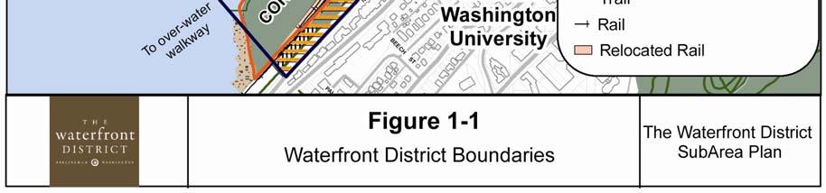
5 1.0 Introduction Bellingham s central waterfront is in a state of transition from its long history as an active industrial site to a new mixed-use neighborhood. Over the past several years, the Port of Bellingham and the City of Bellingham have joined together to create a vision and develop a clear path to transform this vacant brownsfield site into a thriving mixed-use urban neighborhood. In early 2005, the Port of Bellingham acquired approximately 137 acres of waterfront property and tidelands adjacent to Bellingham Bay. This property had been owned by the Georgia-Pacific Corporation, which operated a pulp and tissue mill on the site. This property, along with other Port, City and private properties, made up a project site, which was initially called New Whatcom, and later renamed the Waterfront District. The Sub-Area Plan boundary was expanded in 2012 to include the bluff along Boulevard and State Street to make the boundary contiguous with the Sehome and South Hill neighborhood boundaries and to delete several parcels which overlapped with the Old Town Urban Village Plan. See Figure 1-1 Sub-Area Boundary. CHAPTER ONE INTRODUCTION restore the health of the land and water, improve waterfront access, promote a healthy and dynamic waterfront economy, and reinforce the inherent qualities of the waterfront. The Waterfront District Sub-Area Plan represents a joint planning effort with the City of Bellingham involving residents, landowners, community stakeholders and resource agencies to create a long-term redevelopment opportunity for the Waterfront District. 1.2 Relationship to the 2006 Comprehensive Plan The 2006 City of Bellingham Comprehensive Plan establishes goals and policies to guide future decision-making and coordinate growth within the City over a 20-year planning period. The Comprehensive Plan serves as a guideline for designating land uses, infrastructure development and community services, and long-range implementation strategies. The Waterfront District falls within two urban villages defined in the Comprehensive Plan: the Central Waterfront District and the Central Business District (CBD) Core Village. Infill within urban villages is an essential element of the City growth strategy. 1.1 Purpose of the Sub-Area Plan The Sub-Area Plan s purpose is to provide a framework for future development of the 237 acre site known as the Waterfront District. The Waterfront District Sub- Area Plan includes a balance of environmental, economic and community objectives developed to DRAFT Waterfront District Sub Area Plan Comprehensive Plan Policy FLU-18 requires a master plan to be prepared for each urban village to provide a framework for development. The Waterfront District Sub-Area Plan meets the criteria for a Master Plan as defined in the City Comprehensive Plan. Master or Sub-Area plans for urban villages must specify land uses and densities; street and utilities layout; lot arrangement; housing types; village square or plaza locations; streetscape amenities; relationship of the buildings to the street; parking structures or lots; protection of critical areas; pedestrian and bicycle facilities; and compatibility with surrounding areas. 3

6 The Waterfront District is located within the City of Bellingham CBD Neighborhood. When the CBD Neighborhood Plan was updated in 2008, the neighborhood plan incorporated sections of the Waterfront Futures Group Vision and Framework Plan pertaining to the City Center, which includes the Waterfront District. Concurrent with the adoption of the CBD Neighborhood Plan, the Waterfront District was rezoned to a new zoning category called Waterfront Mixed-Use. This new zoning designation becomes effective upon adoption of the Waterfront District Sub-Area Plan, which more clearly defines the intended uses and development patterns within the area. the Central Business District, Old Town, and adjacent residential neighborhoods. Job opportunities, environmental restoration, and increased public access and recreational opportunities on the waterfront have been identified as priorities for the area. An extensive planning effort was conducted by the Waterfront Futures Group (WFG) in 2003/2004. The Port and City appointed this citizen-led task force to take a fresh and independent look at the future of the entire waterfront in response to the closure of Georgia-Pacific s (GP) pulp and tissue operations. The WFG held 41 public meetings 1.3 The Planning Process Related Planning Processes Bellingham s City Center and Central Waterfront has been a focus of numerous planning efforts since the early 1990 s. Those plans include: Regional Urban Design Assistance Team Report (1992) Visions for Bellingham (1992) Bellingham Bay Demonstration Pilot (1996 present) Whatcom Creek Waterfront Action Program (1996) Downtown Development Workshop (1998) Bellingham Bay Comprehensive Strategy FEIS (2000) City Center Master Plan (2002) Community Forum on Growth Management (2004) Waterfront Futures Group (WFG) Vision and Framework Plan (2005) Bellingham Comprehensive Plan (2006) Central Business District Neighborhood Plan (2008) These planning efforts involved various forms of community input and involvement. Each process identified the Waterfront District as an underutilized area and a vital link between and had 26 guest forums and special events focusing on the future of the waterfront. The WFG completed the community visioning process by publishing the Waterfront Vision and Framework Plan which called for redevelopment of the city center waterfront into a mixed-use neighborhood that combines commercial, institutional, industrial, retail and residential uses, and that over time will provide many new job opportunities and a substantial amount of urban housing. The WFG vision was approved by City Council and the guiding principles and recommendations were used to update Bellingham s Comprehensive Plan and the CBD Neighborhood Plan in 2006 and 2008 respectively. 4

7 CHAPTER ONE INTRODUCTION DRAFT Waterfront District Sub Area Plan 5

8 Public Investment After closure of the pulp mill in 2001, GP explored options to fund the required environmental clean-up to market the property for private development, but the cost of clean-up and the required infrastructure investment made it difficult to attract private investors. During this period, the Port studied the potential acquisition of the GP property to determine if public ownership was viable. The Port purchased the GP property in 2005 after extensive community outreach and partnership commitments from the City and the Washington State Department of Ecology to make the long-term public investments necessary to implement the community s vision on the central waterfront. The Port committed to pay for most of the environmental cleanup, to build marine infrastructure, and to dedicate land for parks, public space and rights of way. The City agreed to build new streets and utilities to serve the site, to develop waterfront parks and trails, and to create a regulatory environment that would attract private investment. The Department of Ecology pledged grant support for environmental cleanup costs. Since acquiring the GP property, the Port and City have secured significant state and federal grant support and have started to spend money on environmental cleanup, habitat restoration and infrastructure design. These public investments are intended to attract substantial private sector investment and generate long-term positive impacts for the community. The Waterfront District Planning Process The Port and City launched a public planning process to develop a Sub-Area Plan for the Waterfront District shortly after acquiring the GP property. To ensure this plan was consistent with the community vision, the Port and City appointed the Waterfront Advisory Group (WAG) to integrate recommendations of the WFG into plans, projects and regulations. From , this citizen-led task force held regular public meetings to gather public input and ensure public awareness and participation in waterfront planning. The Port and City started development of the Sub-Area Plan by inviting neighbors, business owners and anticipated stakeholders to a series of eight workshops and community meetings during 2005 and 2006 to help turn the WFG vision into a Draft Framework Plan, which could be tested under the State Environmental Policy Act (SEPA). During these meetings and workshops, the community evaluated a range of design alternatives that illustrated how infrastructure, development, public parks and trails, and new habitat might take shape on the waterfront. 6

9 The Draft Environmental Impact Statement (DEIS) identified a traffic congestion problem with the proposed street layout in the Draft Framework Plan and evaluated alternate street layouts, densities and other mitigating measures to address traffic, view corridors, historic and cultural resources, critical areas and a range of other important considerations. The Draft Framework Plan also provided an opportunity for the Port and City to assess the project economics. Additional public meetings and workshops were held during 2007 and 2008 to update the community, address specific issues raised by the SEPA analysis and by the public, and receive input to guide development of draft master plan concepts and regulations. During this process, the public provided input on the Waterfront District s character-defining features, view corridors and vistas, preferred land uses, building heights and design standards. The community discussed the role of Western Washington University (WWU) and its plans to create a campus on the waterfront, multimodal circulation, development character, environmental considerations, parks, trails, plazas, economic viability, block sizes, parking strategies, development phasing, historic and cultural resources, and sustainable strategies. A group of local architects volunteered to evaluate the planning concepts and provide recommendations and ideas that maintained the original WFG vision. The Port and City also hired an architectural firm to assess the potential for preservation and adaptive reuse of eleven industrial buildings and structures. This evaluation considered the condition of the historic resources, the cost of construction, market feasibility and compatibility with other planning objectives. CHAPTER ONE INTRODUCTION In addition to the public input received during the planning process, the Port and City received feedback and recommendations from the Waterfront Advisory Group, Western Washington University, Whatcom Transportation Authority, environmental resource agencies, regional and local developers and professional consultants. This Sub-Area Plan is the culmination of these public processes. 1.4 Context Natural and Historical Setting Bellingham s current waterfront is made up of land forms created by filling tidal flat areas over the past century. Before this filling occurred, these tide flats provided food and protection to young salmon as they left nearby rivers and adjusted to salt water in preparation for a journey out to sea. For thousands of years, ancestors of the present day Lummi Nation and Nooksack Indian Tribe relied upon catching the salmon passing the nearshore areas. The beaches and nearshore areas were used by these Native American tribes as seasonal encampments for fishing and shellfish harvesting. For the last 100 years or more, Bellingham s waterfront has served the regional economy as a thriving industrial area, transportation gateway and home to many maritime activities. In 1891, the Great Northern Railroad finished an overwater rail trestle across the mud flats on Bellingham s central waterfront allowing the DRAFT Waterfront District Sub Area Plan 7

10 distribution of goods across a new, nationwide rail network. In the early 1900 s, the Whatcom Creek federal waterway was established and silt from the dredged waterway was used as fill along parts of the waterfront. In 1926, Ossian Anderson opened Bellingham s first pulp mill on the south side of the Whatcom Waterway creating a new economic opportunity for Whatcom County s extensive timber resources. In the years after, Pacific Coast Paper Mills and Puget Sound Pulp were founded and operated as major employers on the waterfront. Through the 1930 s and 40 s, the Bellingham waterfront saw major activity related to the pulp mill and the production of ethyl alcohol (a by-product from pulp mill waste). In the early 1960 s, Georgia-Pacific acquired the waterfront mill site. Operations continued through the following decades, discharging various waste products to adjacent waterways and upland properties. During this time, Bellingham s waterfront industries were largely unregulated and there was not a general awareness or understanding of the importance of environmental stewardship. In 1972, the United States passed the Clean Water Act ushering in a new era of pollution control. In response to the growing framework of environmental regulations, GP built a 36-acre wastewater treatment lagoon on the north side of the Whatcom Waterway to treat process water. The GP mill adjusted to economic trends over the years, but in 2001 the pulping operation was permanently closed down. This signaled a slow decline that continued until Georgia-Pacific closed its Bellingham site permanently on December 21, The Waterfront District Today Today, the Waterfront District is bordered by Bellingham Bay to the west, CBD and Old Town to the east, the Lettered Streets and Columbia neighborhoods to the north, and Sehome and South Hill neighborhoods to the south. Present densities within the Waterfront District are low. There is no residential population and most of the property is vacant with pockets of contamination due to past industrial activities. The site is primarily paved and occupied by inactive industrial structures. Despite its prominent location between Bellingham Bay and downtown Bellingham, public pedestrian and vehicular access is limited and the only recreational use of the site occurs at the southwesterly end of Cornwall Avenue where a small pocket beach is located. Most of the shorelines are hardened with industrial wharfs, bulkheads, and non-engineered rip rap. Redevelopment of the Waterfront District is a once in a century opportunity intended to restore public access along the shoreline and convert the upland area closest to the Central Business District to a vibrant mixed-use extension of downtown Bellingham. Other portions of the site will be remediated and marketed for shipping, marine trades and light industrial uses to replace a portion of the jobs lost when the Georgia Pacific mill closed. 8 8
11 1.5 Redevelopment Potential The redevelopment of the Waterfront District as an urban neighborhood will help concentrate a significant amount of expected population growth within the existing city limits and reduce impacts on agricultural, forest and rural landscapes in the county. The 2006 Bellingham Comprehensive Plan projects a demand for 1,225 infill housing units in the Central Waterfront District Urban Center, and an additional 1,321 units in the Downtown Core Urban Center by the year The Waterfront District encompasses the majority of the vacant land within these two Urban Centers and redevelopment at urban density is an important element in the City s adopted infill strategy. There are 237 acres within the planning area of the Waterfront District, including the ASB lagoon, most of which is currently in public ownership by the Port, City and Washington State Department of Natural Resources. Over half of the project area will be retained for public open space and infrastructure, including 33 acres of new park land, 4 acres of existing public open space, 60 acres for streets, utilities and railroad rights-of-way, and 29 acres for a marina. The remaining 111 acres of Port, City and private property will be available for industrial use or redevelopment for residential, retail, commercial, and institutional use. CHAPTER ONE INTRODUCTION One of the key challenges for this planning effort was the definition of an appropriate goal for the level of development density within the Waterfront District. During initial planning discussions in 2005, the Port and City planning team identified the Fairhaven Historic District as a starting point for evaluating density options. The density of building in Fairhaven, if applied to the entire Waterfront District would result in approximately 6.0 million square feet of building floor space. This density assumption was used in the Draft Framework Plan published jointly by the City and Port in September, 2006, and was used as the medium density development alternative in the evaluation of a range of alternatives in the Environmental Impact Statement (EIS) for the proposal. A low-density alternative of 4.0 million square feet and a high-density alternative of 7.5 million square feet were also analyzed. Based on this analysis and public comment, the medium-range density of 6.0 million square feet of floor space was selected as the preferred alternative in the 2008 Supplemental Draft EIS. As the preferred alternative was further refined, five separate planning areas were defined, each of which has a different redevelopment character and density. The Downtown Waterfront Area is expected to accommodate a density somewhat higher than Fairhaven, while the Marine Trades, Shipping Terminal and Cornwall Beach Areas will be significantly less dense than Fairhaven. The Log Pond Area is proposed to remain in industrial use through the end of the planning period for the Sub-Area Plan. At full build-out, the Waterfront District is projected to have 5.3 million square feet of building capacity, with a mix of commercial, residential, office, institutional and industrial uses. DRAFT Waterfront District Sub Area Plan 9


12 2.0 Vision The community vision for Bellingham s central waterfront has been developed over more than two decades of planning and strategic investment. Some of the key vision statements from the WFG s guiding principles for the City Center character and Central Business District Neighborhood Plan are repeated in this Waterfront District Sub-Area Plan to ensure that the plan is consistent with and implements the City s Comprehensive Plan, Central Business District Neighborhood Plan and the WFG vision. 2.1 Waterfront Futures Group Vision Guiding Principle 1 Reinforce the Inherent Qualities of Each Place on the Waterfront: 1-1. Make the waterfront a regular part of the lives of more people Respect history, cultures, and the arts Make the waterfront inviting to people on foot Reinforce a unique sense of place at different waterfront locations Complement adjacent uses. CHAPTER TWO VISION Guiding Principle 2 Restore the Health of Land & Water: 2-1. Enhance or reintroduce natural systems Create and restore habitat wherever possible Remediate upland and in-water contamination Protect existing natural shorelines Seek opportunities to soften existing hardened shorelines Tailor environmental cleanup strategies and remediation to planned use Manage stormwater to enhance estuarine habitats Require sustainable practices in all development Restore, enhance and expand beaches wherever possible Connect proposed open space and natural areas to regional open space network and natural wildlife corridors Explore mitigation banking and incentives (such as environmental credits) for environmental resource protection and enhancement prior to redevelopment. 10
13 Guiding Principle 3 Improve Waterfront Access: 3-1. Develop strong connections between up lands and water Provide links to regional trail systems Provide multiple modes of access to each area of the waterfront Provide convenient connections between different modes of transportation (jitney/bus). Guiding Principle 4 Promote a Healthy and Dynamic Waterfront Economy: 4-1. Create new mixed-use areas on the waterfront for commercial, industrial, educational, recreational and residential uses Support water dependent activities and uses Create conditions attractive to jobs of the future Strengthen the tie between local jobs and resources Provide public amenities and infrastructure to support redevelopment Improve permitting processes to achieve the goals and principles of the Waterfront Vision Explore economic spin-off related to Bellingham Bay Pilot cleanup strategies Provide incentives and credits for green buildings. 2.2 The Waterfront District Guiding Principles and Implementation Strategies The WAG sponsored a public involvement process during 2005 and 2006, which led to the adoption of New Whatcom Guiding Principles and Implementation Strategies by the Port and City in The Implementation Strategies provide further guidance related to redevelopment of the Waterfront District and are listed in the applicable chapters of this Sub-Area Plan. 2.3 City Of Bellingham Comprehensive Plan The WFG plans, visions, guiding principles and recommendations were used to inform updates to the Bellingham Comprehensive Plan. Accordingly, the visions for the six character areas along the waterfront and 39 general guiding principles were included in the Framework Goals and Policies chapter of the 2006 City of Bellingham Comprehensive Plan. 2.4 Central Business District Neighborhood Plan The WFG guiding principles for the City Center character area were summarized and incorporated into the Central Business District Neighborhood Plan to ensure consistency with, and implementation of the City s Comprehensive Plan and the WFG s recommendations for Bellingham s waterfront. DRAFT Waterfront District Sub Area Plan
14 Create a mixed-use neighborhood, with a combination of commercial, institutional, educational, retail services and housing. Provide a place where people can live, work, study and spend their leisure time without relying on auto transportation. Convert the existing ASB into a new marina or marine habitat. Maintain deep water and transient moorage and marine-related commerce in and along the Whatcom Creek Waterway. Significantly improve public access opportunities throughout the area. Locate WWU and/or other educational or institutional facilities in the area. Acquire the GP property to ensure community involvement in planning for redevelopment and to secure acquisition of land for parks, roads and public access. When implemented, this vision will connect downtown Bellingham with the central waterfront and contribute in a significant way toward the vibrancy of the community and the region. 2.5 Bellingham Shoreline Master Program The City of Bellingham adopted a Final Draft Shoreline Master Program (SMP) in 2009, which is still pending approval by the Department of Ecology. The Final Draft SMP goal for shoreline development within the Waterfront District is: Coordinate shoreline uses to ensure uses that result in long-term over short-term benefit, protect and restore the shoreline resources and ecological functions, increase public access to the shoreline, and promote economic development and accommodate waterdependent uses. CHAPTER TWO VISION The proposed shoreline uses, setbacks and development standards in the Waterfront District Sub-Area Plan are consistent with and implement the Final Draft SMP. The Log Pond area is designated Recreational Shoreline in the Final Draft SMP. The shoreline will have a restored public beach with a 50 foot shoreline buffer, accessible by a pedestrian and bicycle trail. Water-dependent and water-related uses are also permitted within shoreline jurisdiction in the Log Pond area. 2.6 Applicants Objectives The applicants objectives prepared for the Draft Environmental Impact Statement for the Waterfront District, and listed below, reflect the Vision statements adopted over the past two decades of planning and public involvement and are the basis for the plans, policies and implementation strategies included in the Waterfront District Sub-Area Plan: Redevelop the industrial site into a mixed use, waterfront neighborhood providing opportunities for a range of uses and activities. Create a vibrant area that integrates water-dependent uses and open space with new office, retail, services, institutional, and residential uses, and enhances the economy and livability of the area. Connect the Waterfront District Redevelopment project with surrounding neighborhoods including the Central Business District by: ensuring that the redevelopment is compatible with adjacent areas; encouraging uses that complement, not replace, neighboring uses; and integrating new roadway, pedestrian access and trails with surrounding systems. 12


15 Provide community benefits through the phased construction of public open spaces and beaches, pedestrian trails, and moorage for small vessels that fit within the overall intent of the redevelopment plan. Identify opportunities to restore and create habitat along the waterfront environment within the context of creating an economically-viable redevelopment. Ensure that redevelopment is compatible with environmental remediation efforts. Enhance the region s economic vitality by creating conditions that are attractive to a range of employment opportunities and businesses, including water-related industries, research and development ventures, goods and service establishments, and educational and cultural facilities. In conjunction with the City of Bellingham, construct an integrated and economically responsible infrastructure network and public amenities that adequately support phased, long-term redevelopment of the site and stimulate private investment in the project. The ability to provide the infrastructure and public amenity system should be derived from grants and the sale or lease of redevelopment parcels by the Port and from grants, bond financing and tax revenues by the City and other applicable fees and service charges. These sources of capital will be used to offset the initial and ongoing investment in infrastructure and amenities to minimize subsidy from the general tax base of the Port or City. Increase public access to the waterfront by developing pedestrian, bicycle and vehicular connections to/from the site and an interconnected system of trails, viewpoints, walkways, streets, parking and boat moorage facilities. Encourage use of non-motorized transportation modes. Work with non-profit organizations and developers to provide opportunities for a mix of housing products affordable to a range of employees on the site and in the community. Work cooperatively with the City of Bellingham and the public to adopt a Sub-Area Plan and Development Agreement that provide the necessary predictability, consistency and expediency for long-term success of the redevelopment, and allow for flexibility to respond to market factors over time. Encourage sustainable and green development practices as part of future building and infrastructure design and construction at the site. Incorporate features into the planned marina to complement future mixed-use redevelopment, including: boat slip configurations, public walkways/small parks around the perimeter of the marina, and enhanced habitat opportunities. Continue to coordinate with state, federal and local agencies, tribes, organizations, institutions, the public and the private sector to facilitate redevelopment planning and implementation that is successful and an asset to the community. DRAFT Waterfront District Sub Area Plan 13

16 3.0 Environmental Considerations Environmental Cleanup Most of the Waterfront District is built on tidelands, which have been dredged and filled to support over 100 years of heavy industrial waterfront activity. Portions of the site are affected by soil, groundwater and/or sediment contamination caused by historic releases of hazardous substances. Bringing this environmentally compromised land back into functioning and productive use is essential to meet the community vision for the central waterfront. Clean up of contaminated properties is regulated by the Washington State Model Toxics Control Act (MTCA). MTCA is a citizen-mandated law enacted through a voter s initiative and is the state counterpart to the federal Superfund law. Ecology is the lead agency responsible for the implementation and enforcement of MTCA. The mission of Ecology is to protect, preserve, and enhance Washington s environment, and promote the wise management of air, land and water for the benefit of current and future generations. There are six state-listed cleanup sites within the Waterfront District. The MTCA cleanup process includes multiple steps from the initial discovery of contamination, to long-term monitoring to ensure the effectiveness of the cleanup action, to deed restrictions that ensure the long-term integrity of the cleanup action. The Department of Ecology, the Port and the City are working cooperatively to effectively and efficiently integrate site cleanup, habitat restoration, and redevelopment activities. CHAPTER THREE ENVIRONMENTAL CONSIDERATIONS Ecology s cleanup requirements will vary from site to site and will depend on a number of considerations including the nature and extent of contamination and the intended uses of the property. Ecology must select the most appropriate cleanup action for current and reasonable foreseeable uses of the property. Cleanup methods may include treating, removing, or isolating contaminants in order to reduce exposure to humans and the environment. For each site, Ecology will evaluate a range of cleanup options that meet cleanup requirements given the current and planned uses of the property. Environmental cleanup can be effectively and efficiently performed in conjunction with redevelopment activities. For example, if an environmental cleanup requires isolation of contaminated soil to reduce exposure, that isolation could be achieved through paving or buildings. The former GP tissue warehouse, located on the north side of the Whatcom Waterway, is an example of the integration of environmental cleanup and redevelopment. This warehouse was built in 1999 on top of a former municipal landfill and a state-listed cleanup site. The warehouse floor and surrounding parking lot were designed to function as an environmental cap which isolates contaminants in the underlying landfill from humans and the environment. The warehouse foundation includes a vapor control system which releases gases generated as the landfill decomposes over time. Environmental cleanup requirements established by Ecology under state law will be adhered to throughout the redevelopment of contaminated properties within the Waterfront District. 14

17 Figure 3-1: State-Listed Cleanup Sites DRAFT Waterfront District Sub Area Plan
18 CHAPTER THREE ENVIRONMENTAL CONSIDERATIONS There are six state-listed cleanup sites within the Waterfront District. These sites include contaminants at levels exceeding state standards in the soil, surface water, ground water and sediments caused by historic industrial activities. The upland sites were originally tide flats and sub-tidal areas in Bellingham Bay that were filled in, beginning in the mid 1800 s, to support industrial activities. Site Cornwall Avenue Landfill R.G. Haley Georgia Pacific West Whatcom Waterway Central Waterfront I&J Waterway Description This site was used to support a variety of industrial activities from the late 1800 s to 2004 including sawmill operations, a garbage dump, and pulp and paper mill product storage. The site is primarily contaminated with heavy metals, petroleum compounds, and solid waste caused by use of this property from as a municipal landfill. The Port acquired this property in 2005 and is developing cleanup options under Ecology oversight which protect human health and the environment based upon a large waterfront park and mixed-use redevelopment along the bluff. This site was used for a variety of industrial activities from the mid 1800 s to late 1900 s including lumber, coal and wharf operations. The site is primarily contaminated with petroleum compounds caused by wood treatment operations performed by R.G. Haley and other companies from 1951 to The City acquired this property in 2010 and is developing cleanup options, under Ecology oversight, which protect human health and the environment based upon mixed-use redevelopment. This site was used to manufacture paper products from The site is primarily contaminated with petroleum compounds, mercury, metals, and caustic caused by pulp, paper and chemical manufacturing operations performed by GP from The Port acquired this property in 2005 and is developing cleanup options under Ecology oversight which protect human health and the environment based upon a combination of industrial and mixed-use redevelopment. This site, located within the waters of Bellingham Bay including the Aerated Stabilization Basin, is primarily impacted by mercury contamination discharged from GP s former chemical plant from The Port is implementing Ecology s selected cleanup action which protects human health and the environment based upon habitat restoration, a new marina, visitor moorage, marine trades and public access along the shoreline. This site was used to support a variety of industrial activities from the early 1900 s to the 1970 s including a municipal and wood waste landfill, boat yards, foundry activity, petroleum storage, and pulp and paper mill product storage. The site is primarily contaminated with heavy metals, petroleum compounds, and solid waste caused by a range of historic industrial activities. The Port and City acquired most of the privately-owned portions of this site in 2005 and 2006 and are developing cleanup option plans under Ecology oversight which protect human health and the environment based upon industrial mixed-use redevelopment. This site, located within the waters of Bellingham Bay, has been used since the early 1900 s to support a variety of industrial activities including lumber mills, a rock crushing plant, frozen foods processing, and a seafood processing facility. The site is primarily contaminated with metals and phtalates caused by a range of historic industrial activities. The Port is developing cleanup options under Ecology oversight which protect human health and the environment based upon mixed-use redevelopment of the surrounding uplands and ongoing light industrial navigation requirements in the I&J Waterway. 16

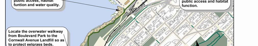
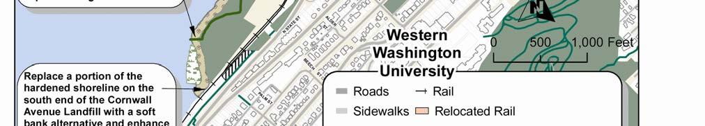
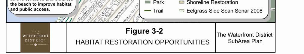
19 Habitat Restoration In 1999, Chinook salmon were listed as threatened under the Endangered Species Act in the waters throughout the Bellingham area. These fish, the largest of the Pacific salmon, once filled the surrounding waters and represented the natural heritage of the northwest coast. A combination of factors including over fishing, the destruction of habitat in the rivers and the ocean, and dams and other barriers, brought these massive fish to the brink of extinction. The decline of salmon is closely associated with the decline in the health of Bellingham Bay and Puget Sound. Over the past one hundred years, there has been a large recession in the population of species which inhabit the surrounding area including forage fish, bottom fish, orca whales, salmon and marine birds. The restoration of shoreline habitat is critical to a coordinated, ecosystem-wide restoration effort and figures prominently into redevelopment plans for the Waterfront District. Bellingham s central waterfront was once surrounded by shallow mudflats and extensive eelgrass beds which offered a surplus of food and protection to juvenile salmon as they left nearby rivers and adjusted to salt water in preparation for a journey out to sea. This natural environment has been devastated by more than a century of unregulated heavy industrial activity on the waterfront. Historic industrial development expanded on top of traditional salmon spawning grounds and the shallow mudflats were filled to create new industrial land. Shorelines were hardened with bulkheads, docks, wharves and rip rap and, as young salmon lost their traditional habitat, they became increasingly vulnerable to predators. economy for many years, some of the existing overwater structures are now recognized as impediments to the new community waterfront envisioned by the WFG. Removing the failing and unused infrastructure will create opportunities to soften and reshape the shorelines to provide richer and more productive habitat for salmon at all tidal stages. Portions of the GP Wharf which are in usable condition will be retained into the future to support water-dependent uses in the Log Pond area. The Port and City, working in collaboration with the multi-agency task force, the Bellingham Bay Pilot, have identified the highest priority habitat restoration areas in Bellingham Bay. The Waterfront District will support Puget Sound recovery efforts by restoring several miles of urban shorelines, removing creosote pilings and unnecessary overwater structures, improving nearshore connectivity, and building more than four acres of new shallow habitat benches. Human activities and the natural environment will be balanced through design solutions which integrate shoreline habitat into mixed-use urban redevelopment. While salmon recovery and the customary return of Chinook will ultimately require all causes of decline to be addressed, the Waterfront District redevelopment will restore critical nearshore salmon habitat and serve as a Puget Sound model for how urban development can be carefully balanced with intricate human-nature interactions. The habitat restoration projects illustrated on Figure 3-2 will occur over time as environmental remediation projects are completed and upland areas are converted to mixed-use development. Today, the shorelines throughout the Waterfront District include a legacy of failing bulkheads, old docks and over-water industrial structures. While these structures were important to the waterfront operations that supported the local DRAFT Waterfront District Sub Area Plan

20 CHAPTER THREE ENVIRONMENTAL CONSIDERATIONS 18

21 Shoreline Development The Waterfront District includes approximately 3 miles of shoreline, which is also subject to the City of Bellingham Shoreline Master Program (SMP). The City of Bellingham adopted an update to the Bellingham Shoreline Master Program in November 2009, which is currently under review by the Department of Ecology. In this draft SMP, the Waterfront District is identified as a Special Area under WAC to allow more detailed planning for this section of waterfront to take place through the Waterfront District Sub-Area Plan. The stated purpose of the Waterfront District Shoreline Designation is: shoreline use area. The draft SMP provides that: The maximum setbacks and buffers within the Waterfront District shoreline mixed-use sub-area may be reduced down to the minimum setbacks and buffers (both as specified in BMC F) as conditioned upon the adoption of a Comprehensive Plan amendment for a Waterfront District Master Plan and Development Agreement for the entire Waterfront District Special Development Area or, upon the adoption of a master plan for a portion of land area within the Waterfront District. To plan for, protect and implement restoration of the shoreline ecological function, reserve areas for waterdependent and water-related uses, maximize public access to the shoreline and accommodate shoreline mixed uses and non-water-oriented uses where appropriate. The Draft SMP establishes Shoreline Management Policies for the Waterfront District, which were adapted from the WFG Guiding Principles for City Center and the Waterfront District Implementation Strategies. The Shoreline Policies and Implementation Strategies in the Waterfront District Sub-area Plan are consistent with and implement the Waterfront District Shoreline Management Policies in the draft SMP. The draft SMP also includes a Waterfront District Development Regulation Matrix with minimum and maximum shoreline setbacks, buffers and height regulations for each DRAFT Waterfront District Sub Area Plan

22 CHAPTER THREE ENVIRONMENTAL CONSIDERATIONS 20
23 Waterfront District Guiding Principles and Implementation Strategies The WAG sponsored a public involvement process during 2005 and 2006, which led to City and Port adoption of Guiding Principles and Implementation Strategies in The following Implementation Strategies provide guidance related to Environmental Restoration, Habitat and Shorelines: Continue to work with State and Federal and local agencies, organizations, institutions, including the Lummi Nation and Nooksack Tribe to be good stewards of the environment. Identify opportunities for cooperative projects and joint funding for shoreline restoration, habitat enhancement, environmental remediation and public access improvements. Evaluate sites identified in the Waterfront Futures Group Opportunities and Ideas for Habitat Restoration and Water Access on Urban Bellingham Bay and other plans and studies for designation as public access and shoreline restoration sites in the New Whatcom* Master Plan and City of Bellingham Shoreline Master Program update. Designate the natural shoreline areas at the head of the I&J Waterway, the foot of Cornwall, and adjacent to the Log Pond for preservation and enhancement as habitat and public access points. Explore opportunities to rehabilitate and enhance hardened shoreline along the Whatcom Waterway, ASB lagoon and other shores for improved habitat and public access. Continue work with NOAA to develop a Clean Ocean Marina standard which incorporates environmental remediation, habitat enhancement, pollution prevention practices and public access, and apply these standards to the proposed New Whatcom* Marina. Make the majority of water s edge accessible via non-motorized means of transportation, including pedestrian walkways, bicycle trails, motorized and non-motorized boat access, and transient moorage, connected to a network of parks, trails and transit connections. Restrict or control public access to areas used for waterdependant industry, sensitive habitat or government agency uses where public access would conflict with public health or safety, habitat protection or national security. * Note: This planning area, originally called New Whatcom has been renamed the Waterfront District. DRAFT Waterfront District Sub Area Plan
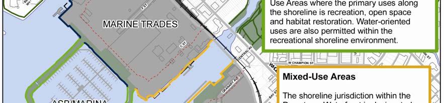
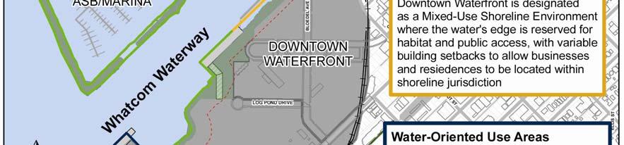
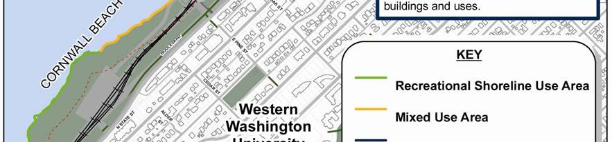
24 3.1 Environmental Considerations Policies Environmental Cleanup Work with Ecology to coordinate the selection of environmental cleanup strategies that are appropriate and compatible with anticipated land uses. Integrate habitat restoration into Ecology required cleanup actions. When implementing Ecology-required cleanup actions, incorporate sustainable strategies to minimize the net environmental footprint. Identify areas within cleanup site boundaries which best support modified Low Impact Development solutions as part of future upland redevelopment. Evaluate the beneficial reuse of dredge material that meets Ecology standards as fill material and as raw material for construction projects. Habitat Where appropriate, replace hardened shorelines with natural beach alternatives in coordination with cleanup and redevelopment activities to enhance habitat, improve aesthetics, reduce long-term maintenance costs, and achieve the stabilization and safety of the shoreline. Protect, restore, and enhance eelgrass habitat. Protect, restore and enhance nearshore habitat connectivity. Protect, restore, and enhance natural habitat forming processes such as stream hydrology, tidal hydrology, sediment supply, wave environment, long shore sediment transport, and the food web. Create shallow water habitats by modifying elevations. Remove creosote-contaminated logs, pilings and debris or replace with non-creosote alternatives. CHAPTER THREE ENVIRONMENTAL CONSIDERATIONS Use Low Impact Development stormwater principles to improve wildlife habitat and enhance estuarine functions. Restrict off-leash dog areas and boat anchoring from sensitive nearshore habitat areas. Develop complex riparian vegetation along the shoreline with designated trails and areas of focused public access to the water. Shorelines The majority of water s edge should be accessible via non-motorized means of transportation, including pedestrian walkways, bicycle trails, motorized and non-motorized boat access, and transient moorage, connected to a network of parks, trails and transit connections. Public shoreline access may be restricted in areas used for water-dependent industry, sensitive habitat or government agency uses where public access would conflict with public health or safety, habitat protection or national security. Shoreline areas within the Cornwall Beach, ASB marina and the head of the I&J Waterway are designated as a Recreational Shoreline Environment where the primary uses within shoreline jurisdiction are public recreation, open space and habitat restoration. Accessory uses intended to support public recreation or serve park visitors should also be permitted in this area. The shoreline within the Log Pond area was also designated as a Recreational Shoreline in the Final Draft SMP. The shoreline will be restored for public access and habitat function. Water-dependent, water-related and water-enjoyment uses are also permitted within Recreational Shorelines. 22
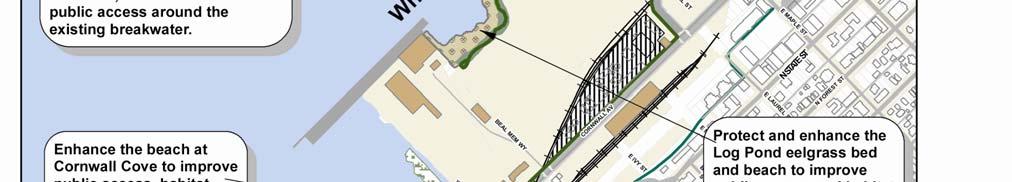
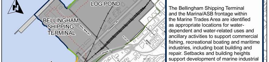
25 The shoreline within the Downtown Waterfront area is designated as a Mixed-Use Shoreline Environment where the water s edge is reserved for habitat and public access, with variable building setbacks to allow businesses, residences, and public facilities to be located within shoreline jurisdiction. Buildings located within shoreline jurisdiction along the Whatcom Waterway should have variable shoreline setbacks and open space between buildings to avoid construction of a wall of buildings close to the water. The Bellingham Shipping Terminal and Marine Trades Area of the Waterfront District are identified as appropriate locations for water-dependent and water-related uses and ancillary activities to support commercial fishing, recreational boating and maritime industries, including boat building and repair. Parking within shoreline areas should be located under buildings or within parking structures located on the upland side of the development unless associated with a water-dependent use or unless no other feasible alternative exists. Surface parking, with appropriate stormwater management, may be developed as an interim use on areas planned for future redevelopment. Where interim surface parking is permitted, the long-term parking strategy and timing of the proposed redevelopment should be specified in the shoreline permit for the project. Streets within shoreline jurisdiction should be designed and aligned in such a manner that the minimum width of travel way for vehicles is provided to facilitate circulation and accommodate future land uses. Shoreline buffers should be managed to preserve, enhance and restore native vegetation and habitat functions. Public trails to provide water access should be permitted within shoreline buffers, provided they are designed and managed to protect or enhance shoreline ecological function. Parks, trails, public plazas, artwork, signs benches and outdoor seating areas should be allowed within shoreline setbacks outside of designated shoreline buffers, other than areas designated for habitat restoration in future park plans. 3.2 Environmental Considerations Implementation Strategies Replace a portion of the hardened shoreline on the south end of the Cornwall Avenue Landfill with a soft bank alternative and enhance the beach to improve habitat function and public access in coordination with cleanup and redevelopment activities in the Cornwall Beach Area. Locate the overwater walkway from Boulevard Park to the Cornwall Avenue Landfill so as to protect eelgrass beds from construction impacts. Enhance the Cornwall Cove beach to improve public access and habitat function in coordination with cleanup and redevelopment activities in the Cornwall Beach Area. DRAFT Waterfront District Sub Area Plan 23
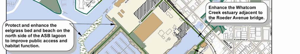
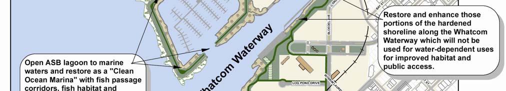
26 CHAPTER THREE ENVIRONMENTAL CONSIDERATIONS Enhance stormwater management at Cornwall Cove beach in accordance with Ecology stormwater standards, in coordination with the upgrade of Cornwall Avenue. Enhance the Log Pond beach to improve public access and habitat function in coordination with cleanup and redevelopment activities in the Log Pond Area. Protect and enhance the Log Pond eelgrass bed. Portions of the hardened shoreline along the Whatcom Waterway which are not being retained for water-dependent uses should be restored and enhanced for improved habitat and a variety of public access experiences upon completion of environmental remediation and in coordination with redevelopment activities in the Downtown Waterfront area. Build public promenades along the waterfront to provide users with vistas of key estuary and habitat areas in coordination with upland redevelopment activities. Figure 3-4: Coordinating Site Redevelopment with Cleanup Requirements 24


27 Enhance the Whatcom Creek estuary adjacent to the Roeder Avenue Bridge. After completion of environmental remediation, the ASB lagoon should be opened to marine waters and restored as a Clean Ocean Marina with fish habitat and public access around the rim of the existing breakwater. The marina should include fish passage corridors through the north and south sides of the breakwater which are located so as to protect existing eelgrass beds from construction impacts. Enhance the shoreline next to the C Street stormwater outfall in coordination with cleanup and redevelopment activities in the Marine Trades Area. This beach shoreline area should not be designated as a public beach due to proximity to the stormwater outfall. Enhance the beach on the north side of the ASB lagoon to improve public access and habitat function in coordination with cleanup and redevelopment activities in the Marine Trades Area. Enhance beach at the head of the I&J Waterway with beach nourishment to support public access and forage fish spawning habitat in coordination with cleanup and redevelopment activities in the Marine Trades Area. Remove creosote-treated pilings and unnecessary overwater structures or replace with non-creosote alternatives. Use sustainable design as part of environmental cleanup where feasible (i.e. design impermeable, rainwater-harvesting structures that act as subsurface caps for deeper contaminated materials but allow for near-surface water movement and infiltration for collection). Continue to work with State and Federal and local agencies, organizations, institutions, including the Lummi Nation and Nooksack Tribe to be good stewards of the environment. Identify opportunities for cooperative projects and joint funding for shoreline restoration, habitat enhancement, environmental remediation and public access improvements. Development within shoreline jurisdiction shall comply with the shoreline buffers, setbacks and height limits for the Waterfront District, established in the Final Draft SMP, upon Ecology approval. Restrict off-leash dogs and boat anchoring from sensitive near-shore habitat areas. Develop an interpretive signage program to educate the public about sensitive habitat areas and access restrictions. DRAFT Waterfront District Sub Area Plan 25

28 4.0 Development Character The Waterfront District redevelopment is intended to implement the community vision for the Central Waterfront by converting a large under-utilized Brownfields industrial site into a vibrant mixed-use neighborhood where people can live, work, shop, study and spend their leisure time, without relying on vehicular transportation. The project will reflect the commitment of Bellingham citizens to environmental stewardship by remediating historic contamination and restoring degraded shorelines to provide habitat for fish, birds and small wildlife species, as well as, opportunities for public access to the water. A network of interconnected waterfront parks, trails and public open space will provide outdoor recreation opportunities and community gathering places to serve the entire Whatcom County community and attract new residents, businesses and visitors to the region. The mix of uses and phasing of development and infrastructure within the Waterfront District is intended to complement and enhance businesses in the Central Business District and adjacent neighborhoods. Development should include a healthy balance between the creation of new jobs and housing opportunities, supported by goods and services. Public ownership of the majority of the land, during the planning phase, will allow some of the land to be leased or sold for development over time. Interim uses are proposed to make use of vacant properties until the development market and infrastructure investment can support more intensive uses. These interim uses include but are not limited to: marine-related light industrial and transportation, construction staging, environmental remediation, alternative energy research and production, food production and surface parking. The policies and implementation strategies in this chapter, and the associated development CHAPTER FOUR DEVELOPMENT CHARACTER regulations, are intended to guide the redevelopment of the site as a compact urban village with sufficient density to support transit and pedestrian-oriented development. Development standards relating to building height, setbacks, and design are proposed to preserve key view corridors to and from adjacent neighborhoods, limit building mass adjacent to parks and rights-of- way, and encourage sustainable design features and amenities to support pedestrian-oriented commercial activity and public gathering space at the ground level. The Waterfront District Downtown Area achieved a Stage 1 Certification under the US Green Building Council s LEED (Leadership in Energy and Environmental Design) for Neighborhood Development pilot program. This program integrates the principles of smart growth, new urbanism and green building and benefits communities by reducing urban sprawl, increasing transportation choices, decreasing automobile dependence, encouraging healthy living, and protecting threatened species. These development strategies are reflected in policies and implementation strategies throughout this Sub-Area Plan. The Waterfront District, Old Town and a portion of the Central business District have also been selected by the Portland Sustainability Institute to participate in the EcoDistrict Program. There is considerable overlap between LEED ND program concepts and EcoDistrict concepts. Where feasible, these concepts have been integrated into the updated draft Sub-area Plan and Development Regulations. 26
29 Waterfront District Guiding Principles and Implementation Strategies The Waterfront Advisory Group sponsored a public involvement process during 2005 and 2006, which led to City and Port adoption of the Guiding Principles and Implementation Strategies in The following New Whatcom Implementation Strategies provide guidance related to Development Character: Redevelop the New Whatcom site with a mix of uses including jobs, housing, retail development, services, educational and cultural facilities and water-dependent industrial uses. Divide the New Whatcom redevelopment area into a number of districts with distinct character and function, developed in phases to correspond with market demand. Encourage a mix of uses which complement, rather than duplicate, businesses in the Central Business District and provide family-wage jobs, including offices, research and development, business incubators, live-work studios, and water-related industries. Maintain a balance between jobs, housing, retail development and services developed on the New Whatcom site. Develop a phasing plan which establishes a ratio between retail, services, offices or institutional uses, and residential development on the site. Encourage the development of businesses which provide goods and services to residents of the site and surrounding neighborhoods, local businesses and employees, and visitors to attractions on the site. Develop size and design criteria which discourage big box stores which draw the majority of their customers from other areas of the City. Work with non-profit organizations and private developers to provide incentives for development of a mix of housing types affordable to the employees of the businesses provided on the site. Include sites for water-related industry and services to support commercial fishing, recreational boating and maritime industries, including boat building and repair to preserve the nautical history of our community. Develop appropriate design features and transitional areas to buffer uses which produce noise, glare or odors from incompatible uses where needed. Capitalize on the synergistic relationship between New Whatcom and adjacent commercial districts by enhancing rather than competing with adjacent areas especially the Central Business District. This can be achieved by an early emphasis on jobs, residential units and other activities which support businesses in the adjacent areas. Work with universities, agencies, organizations and business groups involved in education, art and culture to attract educational and cultural facilities to the waterfront. Work with non-profit organizations and provide a combination of incentives, mandates, and subsidies for private developers to develop a mix of housing types affordable to employees of the jobs provided nearby. Implement land uses that acknowledge Bellingham s deep maritime and cultural history. Design a building scale and business atmosphere which encourages unique, locally owned businesses. Utilize appropriate site design standards, such as Whatcom County Building Industry of Washington Green Community program or Leadership in Environmental Education and Design (LEED) Neighborhood Development standards and encourage new or remodeled buildings to be BuiltGreen or LEED certified. Establish unique urban waterfront design guidelines to encourage contemporary architecture and leading green building techniques that blend with the historic industrial buildings on the GP site and highlight the maritime flavor and cultural heritage of the Bellingham waterfront. Work with Lummi and Nooksack leaders to facilitate their development of cultural and educational facilities which feature Native American culture and history. DRAFT Waterfront District Sub Area Plan 27


30 4.1Development Character Policies Land Use Policies: Encourage a compatible mix of urban density commercial, residential, recreational, institutional, and light industrial uses. Maintain a balance between job creation, housing, and building space for goods and services within the Waterfront District. Allow the market to influence uses within individual development projects. Cluster compatible land uses and adopt appropriate development regulations to establish areas of unique character within different sub-zones of the Waterfront District. Develop a network of waterfront access points, parks, public gathering places and areas for public use and enjoyment throughout the Waterfront District. Integrate parks and open space into development areas to add value to adjacent properties. Encourage pedestrian-oriented development at street level and require the ground floor of buildings fronting on Commercial Street and Bloedel Avenue to be designed for commercial, retail, services or public facility use. Allow these spaces to be occupied by offices or other interim uses until such time as the market supports conversion to commercial use. CHAPTER FOUR DEVELOPMENT CHARACTER Preserve sufficient land for marine cargo and marine-related commercial, recreational and industrial uses in areas with access to navigable waters, and adopt appropriate development standards for these areas which recognize the potential for noise, glare and the need for water access, open yard space and buildings big enough to store and repair large vessels and equipment. Identify a site with sufficient size and expansion space for a campus of higher education or other institutional or business campus and adopt flexible design standards to allow a unique character to be established for this campus area. Allow for opportunities to accommodate a grocery store, elementary school, day care center, recreation facilities and similar services for families with children and encourage construction of such facilities when there is sufficient demand. Establish transitional areas to be used for light industrial use, construction staging, environmental clean-up uses, including temporary storage or treatment of dredge materials, alternative energy research or production, local food production, surface parking and similar interim uses until such time as the market and infrastructure is available for these areas to be developed into more intensive uses. 28
31 Enable the development of inclusive affordable housing for low and moderate income persons. A variety of housing types and price ranges should be available, including housing for elderly and disabled persons, families with children, students and employees of local businesses. Encourage the development of public services, art and cultural facilities which reflect the history of the site and region to serve area residents and attract visitors to the District. Provide for sufficient density to allow public entities to recover investments into land, clean-up costs, parks and infrastructure, through land sales and future tax revenues. Phase development to meet market demand and installation of infrastructure. Sustainable Development Policies: Promote sustainable design strategies and development practices generally consistent with LEED for Neighborhood Design and other sustainable development programs. Ensure that environmental remediation of soil, groundwater and marine shoreline areas occurs prior to or in conjunction with redevelopment. Restore marine shorelines by removing creosote pilings and dilapidated industrial structures and replace with shoreline materials and contours which support ecosystem recovery goals and public access, where appropriate. Encourage re-use and recycling of materials on-site, including re-use of the existing Aerated Stabilization Basin breakwater materials for environmental capping, shoreline restoration and fill for parks and roadways to lower the carbon footprint of the project and reduce impacts on local sand and gravel quarries. Encourage building and site designs which conserve energy and potable water, capture and treat storm water on-site, and utilize alternative energy, recycled wastewater, sustainable building materials and innovative construction techniques. Create a framework for personal wellness and environmental stewardship by providing habitat restoration, outdoor recreation opportunities, convenient recycling and compost facilities, roof top and patio gardens, sites for local food production and facilities to support pedestrians, and alternative modes of transportation such as bicycles, motorcycles, transit and ride-share programs. Incorporate bio-swales and other low-impact stormwater management techniques into landscape medians, street plantings and stormwater systems where possible to provide an aesthetic amenity and reduce the impacts of stormwater runoff. Utilize natural vegetation and low-water use plants in landscape design to avoid the need to use potable water for irrigation. Design circulation systems and parking facilities which encourage non-motorized transportation, transit and ride-share programs, reduce paved driving surfaces, and protect water quality. DRAFT Waterfront District Sub Area Plan 29

32 Site Design Policies: Within mixed-use commercial and residential areas, define pedestrian-scale blocks and building pads by developing a network of interior roads, bicycle routes and pedestrian connections with a block size similar to or smaller than the existing City of Bellingham Central Business District and Fairhaven. Where buildings or blocks exceed 240 feet, require pedestrian through-block routes and pedestrian access through buildings during business hours. Encourage pedestrian-oriented development in mixed-use commercial areas by locating buildings adjacent to the sidewalk on arterial streets, except when set back to accommodate public plazas, outdoor seating, dining, landscaping or artwork. Minimize the visual impact of surface parking by reducing parking space requirements, locating surface parking along interior streets or alleys, behind or within the interior of buildings, or below street grade where feasible, and requiring landscaping or screening of surface parking lots. (See related parking policies in Chapter 5 entitled Multi-modal Circulation & Parking.) CHAPTER FOUR DEVELOPMENT CHARACTER LEED ND Credit Opportunities Note: LEED ND, developed by the US Green Building Council, is one of many different voluntary rating systems to address and achieve sustainability goals, The following plan features provide potential credit toward LEED ND certification: The project includes a balance of housing units and jobs. At least 25% of the total building square footage is designed for residential use, and the project is located within a ½ mile walking distance of 4,900 existing jobs. Half of the housing units are within walking distance of the proposed Western Washington University campus site. Site design policies and development standards encourage walkable streets, with buildings located close to the sidewalk, commercial uses at ground level, doors and windows facing the sidewalk, and pedestrian amenities such as weather protection, benches, lighting and art work at street level. Establish view corridors and design standards to preserve water views from public streets and designated view points within adjacent neighborhoods and establish visual connection with the Central Business District. Encourage public and private open space at ground level through design regulations and incentives for dedication of public open space. Commercial street frontage and pedestrian amenities soften the appearance of parking garages and maintain walkable streets. 30


33 Building Design Policies: Establish design regulations and a predictable design review process to ensure that building designs are consistent with the intended character of the various development areas. Encourage pedestrian-oriented uses on the ground floor of buildings fronting arterial streets within Commercial Mixed- Use areas, and provide street-level amenities, such as awnings, benches, lighting and landscaping to support pedestrian and transit use. Encourage appropriately scaled signs and kiosks integrated with building design and street furniture to identify businesses and direct the public to parks, trails, transit facilities, parking and other locations of interest. Design building roof tops and mechanical equipment with consideration for appearance from the adjacent bluff. Encourage screening, vegetation and use of materials to minimize glare. Establish building heights, density, and design standards relating to building bulk and scale to encourage building forms which are inviting to pedestrians at street level, preserve views to and from adjacent neighborhoods, and have sufficient density to support use of public transit and attract private investment. Recognize the need for larger industrial buildings and less stringent design standards to accommodate marine industrial uses, upland boat storage and other light industrial uses within Industrial Mixed-use areas. Provide setbacks, screening or landscaping to separate Industrial Mixed-use areas from other mixed-use development areas. When residential development is located at street level, the ground flow should be elevated above street level or set back from the sidewalk with landscaping along the street frontage. DRAFT Waterfront District Sub Area Plan 31

34 CHAPTER FOUR DEVELOPMENT CHARACTER 32


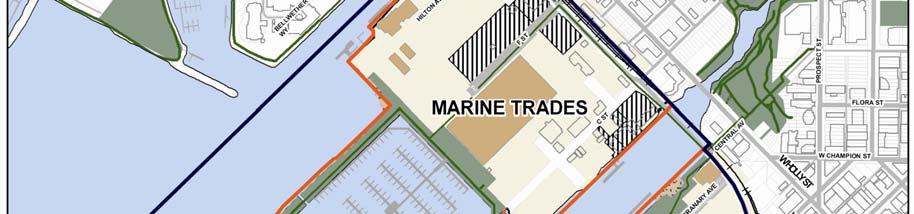
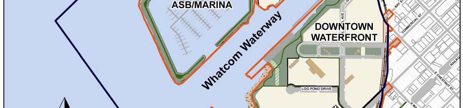
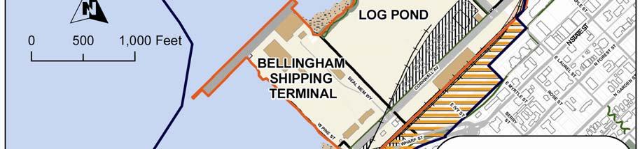
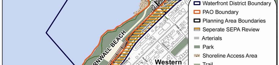
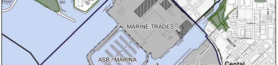
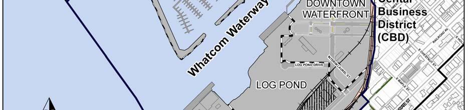
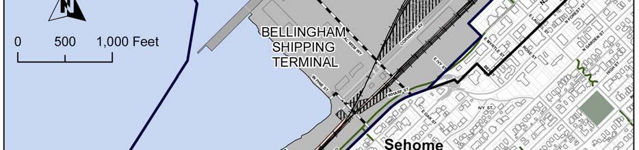
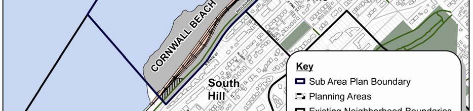
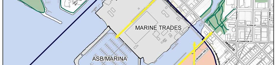
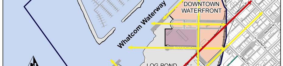
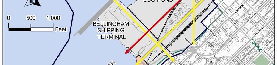
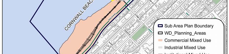
35 Areas of Unique Character The Waterfront District is divided into five areas of unique character where the mix of land uses, density, building types and the layout and design of streets, trails, parks and open spaces will define the character and function of the proposed development: Marine Trades Area This 58-acre area is characterized by a working waterfront that will support a new Clean Ocean Marina which adaptively reuses the wastewater treatment lagoon. The main focus of development in this area is to accommodate jobs revolving around marine trades such as fishing, boat building, boat repair, marine haul out facilities, marine product manufacturing and supplies, research and development. Shipping Terminal Area The existing deep water port in this 25-acre area will be maintained for shipping, port and industrial related opportunities. Industrial uses characterize this area with the potential for use of its peripheral areas to accommodate transitions between related office, transportation, and light industrial uses. The Downtown Waterfront Area The character of this 37-acre area is similar to the commercial portion of the Central Business District (CBD) or Fairhaven. Uses that provide goods and services will mainly serve the population of the area and are not intended to compete with those in the CBD. A mix of housing, office and institutional uses are proposed to be accommodated in a high density configuration centered around the Commercial Street Green open space and Bloedel Avenue. A site for a higher-education or other institutional or business campus is identified along the southern edge. Minimum building heights will be encouraged to establish an urban environment that will become the heart of the Waterfront District. This area s waterfront development will have an urban character with pedestrian-oriented uses encouraged along the waterfront promenade. Log Pond Area This 52-acre area is identified as an Industrial Mixed-use area to be utilized for transportation, construction or light industrial uses through the end of the planning period for the Waterfront District Sub-area Plan. Materials which are manufactured, processed or stored in this area may be imported or exported by truck or by vessel through the Bellingham Shipping Terminal or over the remaining portion of the GP Wharf. The Port is working with Burlington Northern to obtain permission to install a rail spur to serve this area in the future. The shoreline and beach along the Log Pond will be restored for habitat and public enjoyment, accessible via a waterfront pedestrian and bicycle trail and by non-motorized vessel. Public access through this area may need to be interrupted during periods when recreational use would conflict with industrial or cargo activities. Cornwall Beach Area A mix of residential and office uses, with a small amount of goods and service uses are proposed in this 29-acre area. The goods and service uses will mainly serve residents of the Waterfront District and the users of the Cornwall Beach Park, which is a major component of this area, with connections to Boulevard Park via an over-water walkway. Medium density development will be encouraged to relate to the park environment. The Cornwall Beach area includes the bluff located east of the railroad tracks along Boulevard and State Street. The majority of this bluff is in public ownership and is not developable due to steep slopes and limited access. The Environmental Impact Statement for the Waterfront District did not contemplate any development along this bluff. If the private property along the bluff develops in the future, additional planning and SEPA review will be required. DRAFT Waterfront District Sub Area Plan 33


36 CHAPTER FOUR DEVELOPMENT CHARACTER 34
 During initial planning discussions in 2005, the Port and City planning team identified the Fairhaven historic district as a starting point for evaluating density options.")
37 What is Floor Area Ratio(FAR)? Floor Area Ratio (FAR) During initial planning discussions in 2005, the Port and City planning team identified the Fairhaven historic district as a starting point for evaluating density options. The density of building in Fairhaven, if applied to the entire Waterfront District would result in approximately 6.0 million square feet of building floor space. FAR is the gross square footage of a building, excluding structured parking, divided by the square footage of the site. Lower density development is proposed in the Marine Trades, Bellingham Shipping Terminal and Log Pond areas and urban density development is concentrated in the Downtown Waterfront area and the development pad within the Cornwall Beach area. Base and Maximum FAR for the various Waterfront District planning areas are included in the Waterfront District Development Regulations. For example: In both examples above, the building is 10,000 square feet, and is built on a 10,00 square foot lot. This is an FAR of 1.0. If you know the FAR and you want to calculate how much gross floor area you could build, multiply the FAR by the site area. DRAFT Waterfront District Sub Area Plan 35


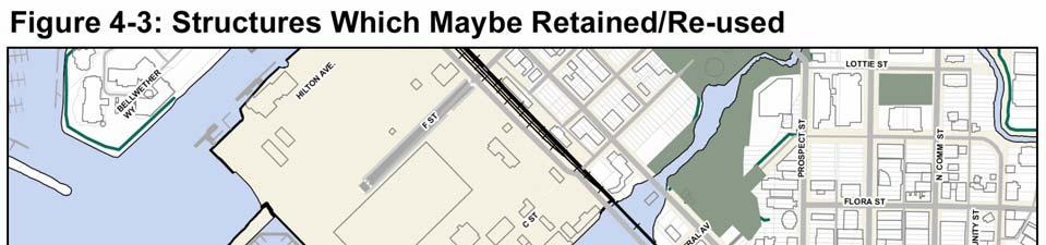
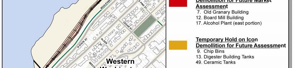
38 Historic and Cultural Resource Policies: Utilize the assumptions, methodology and recommendations from the Waterfront District Adaptive Re-Use Assessment dated 2009, prepared by Johnson Architecture. Temporarily hold certain structures for further market consideration and demolish certain unsafe structures and structures with limited potential for reuse, and salvage or reuse of materials and equipment within buildings and open spaces. Old Granary Building Built: 1928 Dimensions: 121 x110 with 81 x39 office Footprint Area: 16,469 s.f. Resource: Possible adaptive reuse of structure, or relocate and reuse materials. CHAPTER FOUR DEVELOPMENT CHARACTER Document and preserve the rich industrial and Native American histories of the site through photographs and interpretive displays, signage, display of old industrial equipment and tanks, and reuse materials salvaged from demolished structures. Ensure the preservation of culturally significant features through adherence to defined protocols and procedures for site cleanup and redevelopment. Board Mill Built: Ca 1946 Dimensions: 303 x72 Footprint Area: 21,816 s.f. Resource: Possible adaptive reuse of structure, or relocate and reuse materials. Digester Building Tanks Built: Ca 1938 Dimensions: 235 x44 Footprint Area: 10,340 s.f. Resource: Possible reuse of materials, industrial equipment or display of tanks as a park feature. Chip Bins Built: Ca Dimensions: 129 x 51 Footprint Area: 11,938 s.f. Resource: Possible adaptive reuse of structure, or relocate and reuse materials. Ceramic Tanks Built: 1930 Dimensions: 31 x 120 Footprint Area: 1,607 s.f. Alcohol Plant Built: Ca Dimensions: x 50 Footprint Area: 15,575 s.f. Resource: Possible adaptive reuse as park feature, augmented with relocation of other historic equipment and materials. Resource: Possible adaptive reuse of structure, or relocate and reuse materials. 36

39 DRAFT Waterfront District Sub Area Plan 37
40 CHAPTER FOUR DEVELOPMENT CHARACTER 4.2 Implementation Strategies Establish areas of unique character and several different Waterfront Mixed-Use zones to encourage clustering of compatible uses and variation in density and development standards by area. Adopt development regulations, design standards and a predictable and efficient development approval process to implement the community vision established in the Waterfront District Sub-Area Plan. Establish building height regulations and a Floor Area Ratio (FAR) system to encourage urban density development with sufficient critical mass to support transit and pedestrian-oriented mixed-use development. Provide density bonuses to encourage provision of public open space, affordable housing, LEED Silver (or equivalent ) buildings, or acquisition of density credits from the Lake Whatcom watershed. Establish view corridors and design regulations to preserve public views along waterways and to and from street ends, public places and view points within adjacent neighborhoods. Establish a phasing plan to phase building square footage by area to coincide with market demand and the availability of infrastructure, with flexibility to respond to changes in the economy or market and the availability of grant funding or private investment. Establish the character of the early phase development by providing parks, trails, bicycle & transit facilities and pedestrian amenities in conjunction with early development. Implement the Waterfront District Adaptive Re-Use recommendations by actively marketing buildings with adaptive reuse potential, retaining certain industrial icons within public spaces, completing mitigation for removal of structures and demolishing unsafe and/or unusable structures. Work with the Bellingham/Whatcom Housing Authority, Kulshan Community Land Trust and other public and private housing developers to construct affordable housing units within residential or mixed-use development projects. When evaluating alternative development proposals, give priority to proposals which include programs to maintain at least 10% the housing units at levels affordable for purchase or rent by households which earn up to 80% of the City of Bellingham area median income. When subdividing the property include a range of parcel sizes so as not to exclude any potential developers the opportunity to lease or purchase land in the Waterfront District. Evaluate alternative development scenarios utilizing evaluation criteria to balance environmental impacts, economic impacts and community benefit. 38
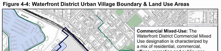

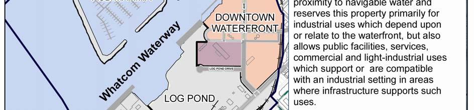
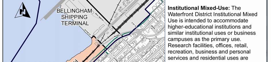

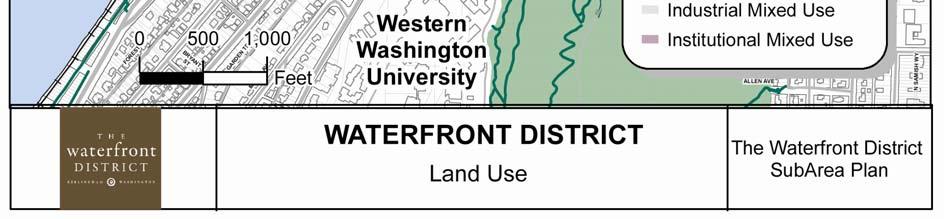
41 DRAFT Waterfront District Sub Area Plan 39


42 5.0 Multi-modal Circulation & Parking The circulation network for the Waterfront District includes a system of multi-modal pedestrian-friendly streets, sidewalks, transit routes and bike paths which will reconnect the City of Bellingham to the waterfront. The street network is one of the most important components for defining the character in each of the five different planning areas within the Waterfront District. In some places, the street design will accommodate commercial and light industrial activities associated with marine trades. In other areas, the streets will be designed as arterials or green streets within a more compact urban environment. Throughout the Waterfront District, the circulation system will encourage people to access and enjoy new community parks, walkways, open space and restored shorelines along Bellingham Bay. The circulation design, policies and implementation strategies in this chapter are intended to provide convenient, cost effective access for people of all ages and physical abilities, while maintaining a walkable character. The Waterfront District has unique opportunities and challenges presented by its location. The street network must integrate a number of functions, if it is to support the successful transition of this area into a new urban neighborhood. Some of the most important functions of the street network include: CHAPTER FIVE MULTI-MODAL CIRCULATION & PARKING Connectivity Waterfront streets will establish new connections between the waterfront and adjacent neighborhoods by extending the existing street grid, new view corridors, and access points, allowing safe transport over the bluff and an active railroad. Local traffic Streets within the waterfront will be designed to serve mostly local traffic and include a number of traffic calming features, such as narrow lanes, paving and sidewalk textures and landscaping to ensure that vehicles move at slow speeds, in keeping with the character of the area. Pedestrian environment A variety of pedestrian features will create a walkable environment, with design adjustments to accommodate a comfortable blend of opportunities for people moving on foot, and using bikes, transit, commercial and personal vehicles. Phased implementation The street network will be constructed gradually over time in planned phases. A biennial monitoring program will provide information on frequency of use and available capacity for each section of the network to assist the City and Port in programming needed infrastructure improvements and maintaining concurrency with adopted levels of service. 40

43 The design objective, whether in the Marine Trades, Downtown Waterfront, or Cornwall Beach area is for a slow-moving experience that encourages safe and comfortable interactions among people using various modes of transit, in pursuit of diverse business and pleasure activities. The parking strategy provided in this chapter is intended to promote a pedestrian-friendly waterfront environment and encourage transit ridership, while providing sufficient parking to accommodate public access, support future businesses and attract private developer investment. Reduced surface parking is a key strategy in creating pedestrian-oriented development. Reduced surface parking will also decrease the total amount of impervious surfaces in the Waterfront District and lessen the impacts of stormwater runoff. Parking policies and design standards support reduced minimum parking space requirements, shared parking, commute trip reduction, and require off-street parking in commercial mixed-use areas to be located behind, beside or under buildings, or within parking structures. These provisions are needed to accommodate the projected density without creating a waterfront dominated by surface parking. Parking will be accommodated through a balanced mix of on-street, surface, integrated structured parking and freestanding garages to support the future development capacity. Initially, on-street parking and low-cost interim surface parking lots will provide much of the parking capacity. As density increases, the interim surface parking will transition to structured parking integrated into the development. The long-term strategy to redevelop surface parking lots as infill sites allows maximum flexibility to encourage initial development without sacrificing the long-term vision of the Waterfront District as a dense urban environment with limited, but sufficient off-street surface parking. Permitting for development will include clear time lines for closure of interim surface lots and provisions for alternate parking facilities upon loss of interim surface parking. The Waterfront District is split in two sections by the Whatcom Waterway. Properties north of the Whatcom Waterway are accessed by C Street, F Street and Hilton Avenue, which connect to Roeder Avenue. These streets have historically provided automobile and truck access to businesses on the site. In the future, F Street will be upgraded to be the primary access to the new marina and businesses, and will include sidewalks and dedicated bicycle lanes. Hilton Avenue and C Street will become local streets designed to accommodate truck traffic, forklifts, large and heavy freight and boats on travel lifts. Properties south of the Whatcom Waterway are accessed primarily via Cornwall Avenue. Central Avenue historically provided access to the GP mill site via Roeder Avenue and is temporarily closed and gated. Wharf Street provides limited access to the south end of the site. A network of private streets which historically provided access within the GP paper mill is currently closed to the public. Currently, bus service is available within a few blocks of the site on Holly Street and State Street. This service will need to be extended through the site as it develops. A network of pedestrian, bicycle and transit routes serve the surrounding Central Business District and neighborhoods. Sidewalks along Cornwall Avenue, Chestnut Street and Roeder DRAFT Waterfront District Sub Area Plan 41

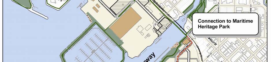
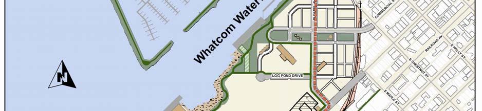
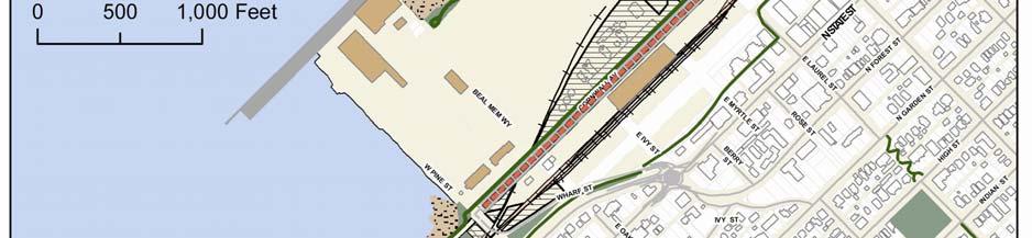
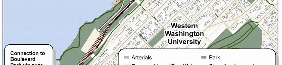
44 CHAPTER FIVE MULTI-MODAL CIRCULATION & PARKING 42
45 Avenue currently provide pedestrian access to the site, which will be extended along the new roads constructed within the development areas. Bicycles currently share traffic lanes with automobiles on Cornwall Avenue. The South Bay trail provides pedestrian and bicycle access to Fairhaven along the top of the bluff at the southern end of the site. This bicycle network will be expanded with dedicated bike lanes on all arterial streets through the site as it develops. The main line of the Burlington Northern Railroad passes through the site, with active rail crossings at Cornwall Avenue, Wharf Street and Laurel Street. Passenger trains pass through the site and stop at the Fairhaven Station, approximately 4 miles south of the site. Relocation of the railroad to a corridor along the base of the bluff is proposed to allow development of an efficient road grid within the site and avoid at-grade rail crossings. A portion of the old rail way could be retained as a side spur to serve the Bellingham Shipping Terminal. The Waterfront District is also accessible by water. The Bellingham Shipping Terminal provides deep-water access to ocean-going ships. Navigable waters in the Whatcom and I&J Waterways provide water access, loading and off-loading, and haul-out facilities for commercial fishing boats, barges and recreational boats. Pocket beaches at the head of the I&J Waterway, north of the ASB lagoon, the Log Pond, Cornwall Cove, and south of the Cornwall Avenue Landfill could be upgraded for hand carry boats. The Waterfront District has unique opportunities provided by its location, but also has limitations due to the topography, soils, historic contamination, the railroad, water bodies, view corridors, historic resources, the location and elevation of existing facilities, future tenant requirements, constructability and cost. DRAFT Waterfront District Sub Area Plan The Environmental Impact Statement (EIS) evaluation of the site provided insight into many of these issues and provided analysis of a number of circulation options, designs and construction sequences. Specific on-site and off-site mitigation measures are identified in the Final EIS and 2012 EIS Addendum for each phase of development. A phased network of transportation system improvements is proposed to accommodate the needs of automobiles, pedestrians, cyclists and transit. At full build-out, the network will consist of a fine grid of interconnected multi-modal streets, trails, dedicated bike lanes and transit routes to integrate the Waterfront District with surrounding neighborhoods. However, redevelopment is expected to occur over a relatively long time frame. Phased construction of the circulation network will focus development in specific areas so that a cohesive feeling for the Waterfront District is maintained over time as growth occurs. Interim roads and trails will provide connectivity in some areas until permanent infrastructure can be constructed. An Infrastructure Phasing Plan is included in the Development Agreement, Planned Action Ordinance and Facilities Agreement, proposed for adoption concurrently with the Waterfront District Sub-area Plan. The phased installation of a multi-modal system of streets, walkways, bike paths, trails and transit routes in the Waterfront District will be monitored and managed over time, in order to encourage preferred patterns of development, but also to take advantage of unplanned opportunities that may arise. Redevelopment of the waterfront is taking place during a time when traditional patterns of land use and transportation are being adjusted. Climate change, for example, is placing demands on local communities to explore and encourage shifts in how people get from one place to another. The City s Comprehensive Plan Goal anticipates a 9% increase in mode shift, above existing, from cars to other forms of 43

46 transportation (e.g., walk, bike, transit) by The goal proposed for the entire Waterfront District is even more ambitious, with approximately 14% increase above existing, because this redevelopment project will include mixed-use urban-density development and provides the opportunity to build a more modern system of multi-modal transportation from the beginning, rather than retrofitting existing infrastructure. While this goal is not a regulatory requirement, it is an important feature of the multi modal circulation system to avoid traffic congestion and encourage non-motorized access. Management of the transportation system will be data driven. A biennial traffic monitoring program will be established for the waterfront. Data collection under the program will be conducted during the evening peak traffic hour and include the following components: Traffic Counts. Daily and peak hour traffic counts at all site access locations. Vehicle Classification Counts. Daily and peak hour vehicle classification counts at the site access locations, including trucks, cars and transit. Pedestrian and Bicycle Counts. Peak hour pedestrian and bicycle counts at each site access location. The ability to achieve certain mode shifts is influenced by the land use within each planning area. Separate monitoring will be required in each of the five planning areas, and mode shift expectations may be different for each area. The Marine Trades Area, for example will typically have a higher auto use due to the type of activity in that area. The data collected for each planning area will be used to confirm when street infrastructure improvements are required and will be used to make adjustments to concurrency CHAPTER FIVE MULTI-MODAL CIRCULATION & PARKING determinations for planned redevelopment. In addition, the data will be used to assist in understanding whether mode share targets are being achieved. The ability to meet or exceed mode share targets may reduce the level of infrastructure improvements required to serve the site. Conversely, the inability to meet targets may require a reduction in the overall level of development accommodated during any given phase of development. The response to mode shift data may take many different forms, including such things as behavioral adjustments, operational and/or engineering solutions, or policy determinations or some combination thereof. Behavioral adjustments by people accessing the waterfront may come in the form of people choosing to shift from cars to walking, biking or transit because of congestion. Operational solutions may take the form of having curb-side parking be limited during peak hours in order to provide an additional lane for vehicle traffic (e.g., cars, carpools, or dedicated transit lanes). Engineering solutions may include modifying existing roads, or construction of the next segment of street infrastructure before additional development occurs. A policy determination may be made that the public is satisfied with clogged intersections for an hour a day in order to keep the walkable character of the area. 44

47 Figure 5-2: Mode Share Assumptions To reduce the demand for transportation infrastructure and parking, the Waterfront District is designed to increase the percentage of travelers using pedestrian, bicycle, transit and other non automobile modes to 30% of total trips over time. Early phases of infrastructure are designed to activate the northern portion of the Downtown Waterfront Area, providing strong connections between downtown and the waterfront. The installation of park and trail connections will also occur in incremental phases in conjunction with installation of streets and utilities. The combination of transportation and public access features in early phases will create strong physical and visual connections between downtown and the waterfront and establish signature parks and public access features along the south side of the Whatcom Waterway. The Log Pond Area will continue to be used for light industrial activities without any significant public investment in roads or utilities. As the Downtown Waterfront Area gradually develops into an urban village, infrastructure will be expanded as necessary to serve proposed development and increase public access to the waterfront. Additional infrastructure will also be installed in the Marine Trades Area and the Cornwall Beach Area in later planning phases. Installation of the transportation network, public parks and trails will be managed over time in response to development trends and opportunities, funding availability, community priorities, and the schedule for railroad relocation. DRAFT Waterfront District Sub Area Plan 45
48 CHAPTER FIVE MULTI-MODAL CIRCULATION & PARKING Guidance from the New Whatcom Strategic Guidelines and Implementation Strategies (now known as the Waterfront District) The Waterfront Advisory Group sponsored a public involvement process during 2005 and 2006, which led to the adoption of New Whatcom Guiding Principles and Implementation Strategies by the Port and City in The following Implementation Strategies provide guidance related to Circulation: Develop a network of interconnected pedestrian, bicycle and transit facilities within the site with connections to adjacent neighborhoods and parks. Design the living, working and shopping areas with a pedestrian scale, which is not dominated by vehicles. Dissolve the barriers that separate the waterfront from the Bellingham Central Business District, connecting the City with the Bay. Develop strong vehicular and pedestrian connections between New Whatcom, E. Holly Street, Roeder Street and State Street, while acknowledging and creatively working the obstacles of topography and the railroad. If there is a WWU presence on the New Whatcom site, develop a connection to the WWU campus. Encourage non-motorized transportation by creating a park once environment that makes it safe and attractive for pedestrians or bicycles to connect to amenities, goods and services, jobs and housing. Provide covered transit stops, pedestrian facilities and bicycle parking areas to support non-motorized travel. Encourage frequent, convenient and well designed transit service as well as sufficient density to support it. Connect the New Whatcom open space and trail network to Boulevard Park with an over water trail from the south end of the Cornwall Landfill to Boulevard Park. Parking should be thought of as infrastructure and must be convenient, ample, efficient and affordable, and facilitated or managed by a local jurisdiction. Generally, parking should be located under buildings and in parking structures located away from the shoreline, unless associated with a water-oriented use. Subject to the Sub-Area Plan design and phasing, surface parking may be developed as an interim use on areas planned for future redevelopment, enabling its evolution over time into a denser environment. 46

49 5.1 Multi-Modal Circulation and Parking Policies Circulation Policies The Waterfront District should be designed to increase pedestrian, bicycle and transit usage through the installation of appropriate infrastructure, land-use mixture and density, site design, policies, and education. Develop a transportation system which enables the movement of more people in proportionately fewer automobiles. Spatially connect the City to the waterfront through a network of new interconnected roads and trails designed to accommodate pedestrians, bicycles, automobiles, trucks and transit. Integrate and connect new waterfront streets and trails to the existing network of streets, bike routes and trails within the Central Business District (CBD) and surrounding neighborhoods. Block size within commercial mixed-use areas should be similar to or smaller than blocks in the existing CBD and Fairhaven. Blocks exceeding 240 feet in length or depth should include an alley or pedestrian access through the block. Large buildings on oversize blocks should include pedestrian access through the building during business hours. Blocks within the Shipping Terminal, Marine Trade Area and Log Pond Area may be larger to accommodate marine transportation and industrial uses. All streets and sidewalks should be open to the public and available for general public use, with the exception of streets within the Bellingham Shipping Terminal and portions of the site where active environmental clean-up, construction or industrial activities require site security or could pose a hazard to the public. Cul-de-sacs should be avoided unless temporary in nature or required to access areas constrained by water bodies, the railroad or bluff. If new cul-de-sacs are created, pedestrian or bicycle through-connections shall be provided to adjacent blocks, where feasible. All streets should be limited to a maximum speed of 25 miles per hour. Sidewalks or foot paths should be provided on both sides of all arterial and local streets within mixed-use areas. Pedestrian access to uses within Marine Industrial areas may be separated from traffic routes for safety. Sidewalks, crosswalks and walkways shall be designed in compliance with the accessible design provisions of the American Disabilities Act (ADA). Dedicated bike lanes should be located within or adjacent to all arterial streets, so that all residences, businesses and public facilities have easy access to a dedicated bicycle route. Local streets may include bicycle lanes shared with automobiles. DRAFT Waterfront District Sub Area Plan 47
50 Businesses, public facilities and residential developments should provide bicycle parking spaces or storage. Safe and comfortable transit facilities should be located at major trip generators to encourage transit use and reduce driving. Where feasible, transit stops should be located adjacent to buildings with weather protection or include shelters and benches, partially enclosed to buffer wind and rain, with lighting, route information and schedules. A variety of boat and barge docking, moorage and launching facilities and services should be developed to provide water access for boats of all sizes, support water transportation and make the Waterfront District welcoming to visiting boaters. Per City policy, this area receives an impact fee credit for the number of PM peak hour vehicle trips generated by the former Georgia Pacific Mill and other recent industrial uses within the Waterfront District. Transportation Impact Fees should not be imposed until such time as development exceeds the historic number of PM peak hour vehicle trips generated in this area, which will likely occur after early development phases; however, transportation impact fees should be phased in when redevelopment exceeds the threshold of historic transportation impact defined by number of PM peak hour vehicle trips. Streetscape Policies Encourage building design which supports pedestrian-oriented commercial activity and provides opportunities for visual or interactive links between businesses and CHAPTER FIVE MULTI-MODAL CIRCULATION & PARKING pedestrians within commercial or mixed-use areas. In commercial and mixed-use residential areas, street furniture, artwork and shielded lighting should be provided along streets and within open spaces adjacent to streets to create comfortable outdoor gathering places for residents and visitors. The specific design of the street furniture and lighting should be reviewed at the time each phase of development is proposed to ensure a compatible design which contributes to the cohesiveness of the area, but allows for variation between the unique development areas. Within commercial and institutional mixed-use areas, street trees should be planted between the vehicle travel way and the sidewalk on arterial streets at intervals no greater than 50 feet. Within view corridors, tree species should be selected to minimize view impacts. Street trees should not be required along interior streets in Industrial areas where they could conflict with industrial traffic, but should be provided along F Street and Roeder Avenue. The exterior boundaries of industrial areas and boat yards should be landscaped where they abut commercial mixed-use areas, parks or public roads. Landscaping should feature native or drought tolerant plants which do not require permanent irrigation systems. Where feasible, streets should be designed with bioswales, tree wells or other natural stormwater treatment facilities to treat stormwater run-off from roads and double as landscaping. Parking lots, garages, and waste disposal facilities should be screened from public streets and trails. 48

51 Transit stops, transit pull-outs and shelters should be located along all arterial streets at convenient intervals and should have priority over on-street parking and landscaping. Well designed signage and way-finding should be located at frequent intervals to direct visitors to business districts, parking, transit stops, bicycle and pedestrian routes and public places throughout the Waterfront District and provide public information about site history and natural features. Figure 5-3: Parking Strategies Parking Policies Parking should be provided through a combination of on-street, surface and structured or below-grade parking facilities, with on-street parking spaces reserved for short-term visitors and customers. Minimum parking requirements should be reduced to a standard which is appropriate for a mixed-use urban setting in the future, assuming fewer cars, smaller cars, shared parking facilities and mode-shift to non-auto modes. Regulations should include provision for further reduction to parking space requirements for uses which provide shared parking facilities and programs to reduce automobile dependence. At full build-out, no more than one-third of the total automobile parking spaces in Commercial or Institutional mixed-use areas should be provided in off-street surface parking lots. Within commercial mixed-use areas, surface parking lots and the entrances to parking garages should be located at the side or rear of buildings, and off-street parking lots should not be located between the building and the street. DRAFT Waterfront District Sub Area Plan 49
52 Within shoreline jurisdiction, parking should be located under buildings, or within parking structures located away from the shoreline, unless associated with a water-oriented use. Parking should not be located between the building and the shoreline. Surface parking may be developed as an interim use on areas planned for future redevelopment, enabling its evolution over time into a denser environment. Where interim surface parking is permitted, a clear strategy and time line for development of permanent parking spaces and redevelopment of interim surface lots should be established in development permit conditions. In areas where development sites abut the bluff, streets should be designed to provide space for parking within buildings below street grade, with building entrances at street level. Parking lots should be designed to reduce heat island impacts by limiting the size of surface parking lots, providing landscaping to shade parking lots and encouraging covered or structured parking. Parking lots and structured parking should be designed to include pedestrian walkways connecting the parking facility to the buildings or uses which they serve, and should be landscaped or screened from adjacent streets and walkways. If a structured parking facility is located at street level, the street frontage along any arterial street should be occupied by a retail, service or public use, or the facility should include landscaping, art work or outdoor seating along the street CHAPTER FIVE MULTI-MODAL CIRCULATION & PARKING frontage, subject to design review. Bike parking or covered storage areas should be located near the entrances to all public and private buildings, facilities or clusters of uses. Central bicycle facilities may be provided for institutional campuses or business parks with internal pedestrian routes. LEED ND Credit Opportunities Note: LEED ND, developed by the US Green Building Council, is one of many different voluntary rating systems to address and achieve sustainability goals, The following plan features provide potential credit toward LEED ND certification: Walkable streets include on street parking, street trees, sidewalks, bike lanes and pedestrian oriented development at street level. Project will encourage transit use and reduce driving by providing safe and comfortable transit facilities. Parking is designed to increase pedestrian orientation and minimize the adverse effects of parking facilities by limiting the size and location of surface parking lots and providing bicycle and car pool parking. 50


53 Integrated Slopes Approach The existing site grade in the Downtown Waterfront Area is approximately 30 feet below the level of the existing downtown at Commercial, Cornwall and Bay Streets. Site conditions pertaining to water tables, potential sea level rise and soils make it unfeasible to excavate below the existing grade for underground parking. Raising the street level across the site provides the opportunity to install below-grade parking with pedestrian scale uses at street level. This approach also allows placement of utilities and stormwater systems under streets with minimum excavation. In order to provide the possibility for below-grade parking and reduce the Figure 5-4: Integrated Slopes grade difference between the downtown and the Waterfront District, an Integrated Slope Approach is envisioned to raise the elevation of the streets within the Downtown Waterfront area a minimum of 10 feet. Street grade will slope upward from the shoreline to the Central Business District, providing the potential for up to three levels of below-grade parking along the bluff adjacent to Roeder Avenue and Chestnut Street. This approach for parking will also create a noise buffer between the relocated BN/Santa Fe railroad tracks and the Waterfront District development. This configuration could provide the opportunity for parking garages within the Waterfront District to be accessed from existing downtown streets, reducing the amount of automobile traffic traveling on Waterfront District streets. DRAFT Waterfront District Sub Area Plan 51


54 5.2 Implementation Strategies Design a network of arterial streets and trails to serve as the primary vehicle, bicycle and pedestrian access routes to development sites and public amenities within the Waterfront District. Phase the development of arterial streets, trails and infrastructure to coincide with environmental clean-up, the development of adjacent properties, funding availability, and the schedule for railroad relocation. Design and construct local streets, alleys, bike and pedestrian routes to provide access to individual buildings and parking areas at the time development is proposed. Where feasible, install streets and utilities on clean fill placed above the current ground level to minimize excavation in areas with contaminated soils and elevate streets above potential flood levels which could result from the impacts of global warming, sea level rise or storm surge events. CHAPTER FIVE MULTI-MODAL CIRCULATION & PARKING Adopt design standards which encourage an appealing and comfortable pedestrian street environment within commercial and residential mixed-use areas with buildings located contiguous to sidewalks, building entrances facing public streets, transparent glass on businesses at ground level, weather protection, landscaping, artwork, lighting and outdoor seating areas. Allow alternate design standards to be established for institutional campuses or business campuses with internal pedestrian access. Work with the Whatcom Transportation Authority (WTA) to ensure adequate funding for an efficient, convenient transit system with stops located in close proximity to the majority of residences and businesses, prior to occupancy of the first 1 million square feet of building space. Obtain input from WTA regarding street design to ensure bus maneuverability around the site, allowing convenient connections to Downtown, Fairhaven and Western Washington University. 52
55 Provide transit with priority access to the site if needed. This may include transit only lanes, shared bike/transit lanes, signal priority, or on-street parking lanes which convert to transit lanes during peak hour. Work with Burlington Northern Railroad and seek grant funding to relocate the main line of railroad to a new route along the bluff, while maintaining a rail spur to serve the Bellingham Shipping Terminal and Log Pond transitional use area. Encourage landscaping, park design, and stormwater biotreatment facilities, such as bioswales, and use of native and/or drought tolerant plants which will not require permanent irrigation systems and support clean stormwater goals. Maintain the Bellingham Shipping Terminal as a deepwater moorage and cargo facility, with adequate upland laydown area to support this use. Develop a Clean Ocean Marina by adaptively re-using the ASB to serve the need for moorage. Develop launching facilities and services for hand carry boats in one or more of the following areas: at the head of the I&J Waterway, north of the ASB lagoon, the Log Pond, Cornwall Cove, and/or south of the Cornwall Avenue Landfill. Develop visitor moorage facilities along the Whatcom Waterway and encourage the development of services to attract visiting boaters to the Waterfront District. Maintain and upgrade piers, moorage facilities and boat lifts along the north side of the Whatcom Waterway and south side of the I&J Waterway, and develop additional commercial boat haul-out facilities if needed to improve marine industrial water access. Work with private carriers and pursue grant funding to assist in developing a network of water-taxis or a small ferry system to connect the Waterfront District to other transportation links. Encourage landscaping with native or drought tolerant plants which do not require permanent irrigation systems. Develop parking regulations and design regulations to prevent parked cars from dominating the landscape by reducing minimum parking requirements below existing city code requirements, encourage shared parking and commute trip reduction, and requiring surface parking lots to be located behind buildings and screened from public roads and trails. Develop and implement a biennial traffic monitoring program to collect data and use results to encourage mode shift from cars to alternate forms of transportation such as walking, biking and transit, consistent with mode shift goals. Take steps designed to encourage early development within each planning area in order to obtain the type of anchor tenants that will help define the character of development consistent with the Sub-Area Plan. Develop an engineering response to the potential future closure of the at-grade crossing at Wharf Street that will support safe access to the Waterfront District by bicycle riders and pedestrians. DRAFT Waterfront District Sub Area Plan 53

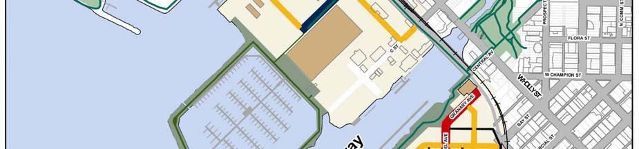
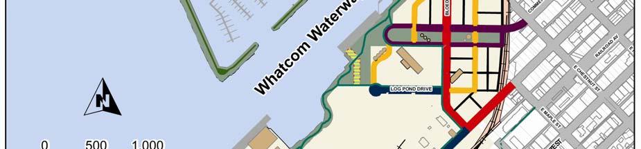
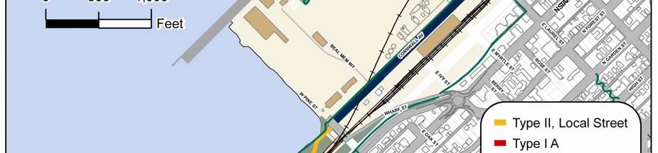
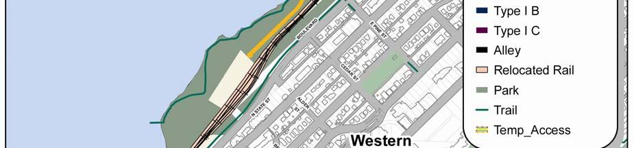

56 CHAPTER FIVE MULTI-MODALCIRCULATION&PARKING 54

 Bikes: Two dedicated bike lanes Parking: Parallel parking on one or both sides of street.")
57 Figure 5-6: Waterfront District Street Designs Type IA - Arterial Streets ROW: 85 ft. (2-way street) with one turn lane at intersection or optional center landscaping. Bikes: Two dedicated bike lanes Parking: Parallel parking on one or both sides of street Landscaping: Street trees, highlighted landscape areas at wide sidewalk, natural biofiltration option in lieu of on street parking on one side of street. Pedestrian Environment: Sidewalks on both sides of the street along with ground floor retail and commercial uses encourage pedestrian-oriented activity. Type IB - Arterial Streets ROW: 72 to 82 ft. (2-way street) Bikes: Two dedicated bike lanes Parking: Parallel parking on one or both sides of street. Landscaping: Street trees, natural biofiltration option in lieu of on street parking on one side of street. Pedestrian Environment: Sidewalks on both sides of the street encourage pedestrian oriented activity. DRAFT Waterfront District Sub Area Plan 55
 Bikes: Three dedicated bike lanes (2 on 2-way street & 1 on 1-way street) Parking: Parallel parking both sides of the 2-way street & one side of the 1-way street")

58 CHAPTER FIVE MULTI-MODAL CIRCULATION & PARKING Type IC - Arterial Street Commercial Street Green ROW: 210 TO 220 ft. (2-way street & 1-way street) Bikes: Three dedicated bike lanes (2 on 2-way street & 1 on 1-way street) Parking: Parallel parking both sides of the 2-way street & one side of the 1-way street Landscaping: Street trees, potential for biofiltration, mill artifacts & landscape features within the center open space area. Pedestrian Environment: Primary pedestrian link from downtown; encouraged activity at the ground floor. Sidewalks on both sides of the street and park. Type II - Local Streets ROW: 36 to 56 ft. (2-way street) Bikes: Auto lane shared with bikes (lane striping to indicate shared auto/bike environment). Parking: Optional parallel parking or bioswale on one side of street. Landscaping: Street trees, low scale shrubs and ornamentals over utility vaults. Landscaping requirement may be waived within industrial areas. Pedestrian Environment: Sidewalks on both sides, or optional sidewalk on one side and other side landscaped when located adjacent to park or trail with equivalent pedestrian facilities. Within industrial areas, separated pedestrian route may be provided. 56


59 CHAPTER SIX 6.0 Utility Systems UTILITY SYSTEMS The Waterfront District requires an expansion of utility services to support the anticipated levels of development. Public and private utility suppliers have the capacity to service the full amount of planned development and system upgrades will be made in coordination with the site development schedule. Traditional conveyance lines for water, sewer and stormwater will be included in City rights-of-way. A non-potable, treated waste water conveyance system may also be located in City rights-of-way for irrigation use. These new utility corridors will be pre-excavated and backfilled with clean materials during the initial phase of utility and roadway installation, consistent with site cleanup activities. A utilities master plan, evaluating existing systems and envisioned improvements, will be prepared by the City s Public Works Department prior to site development to provide a framework for the short-term and long-term improvements. Innovative systems to treat or recycle wastewater or stormwater run-off within buildings or sites will be privately developed and maintained. Water The City provides water service to customers in and around the Waterfront District. The City s Capital Facilities Plan, updated in 2006, affirms that improvements to the existing water system can service the full amount of planned development. Potable water mains surround the Waterfront District and extend into the site at a number of locations (Beal Memorial Way in the vicinity of the Oak Street right of way, Pine Street, Laurel Street, C Street, F Street, Hilton Avenue). Additional water system infrastructure will be placed within the site s new roadway network contingent on site development needs and in coordination with other utility system improvements. Sanitary Sewer The City provides sanitary sewer utility service to customers in and around the Waterfront District. The City s Capital Facilities Plan, updated in 2006, affirms that improvements to the existing sanitary system can service the full amount of planned development. Sewer pipes surround the Waterfront District and extend into the site at a number of locations (Beal Memorial Way, Pine Street, Laurel Street, C Street, Hilton Avenue). The majority of the site s existing gravity sewer system, especially in the area south of the Whatcom Waterway, will be reconstructed and relocated within the site s new roadway network contingent on-site development needs and in coordination with other utility system improvements. New on site pump stations will be required to help transport collected wastewater to the Post Point Pollution Control Plant. DRAFT Waterfront District Sub Area Plan 57


60 Electricity Puget Sound Energy (PSE) provides electricity to customers in and around the Waterfront District. PSE is expanding its electrical substation system to meet the area s long-term energy demands and will accommodate the planned levels of development in the Waterfront District contingent upon energy demands and site development needs. Most of the site s existing electrical lines will be removed or replaced with below-grade lines within the site s new roadway network in coordination with other utility system improvements. Natural Gas Cascade Natural Gas provides natural gas service to customers in and around the Waterfront District. Cascade Natural Gas has sufficient capacity to service the full amount of planned development in the Waterfront District. A 16-inch high-pressure natural gas distribution line traverses the perimeter of the site along Roeder Avenue, Chestnut Street and Cornwall Avenue and gas lines extend into the site at a number of locations. Most gas lines will be removed or replaced within the site s new roadway network contingent on site development needs and in coordination with other utility system improvements. Stormwater Management The careful management of stormwater is a high priority for waterfront communities throughout the Puget Sound. Federal, state and local regulatory requirements for stormwater management have become increasingly stringent in an ongoing effort to protect adjacent marine resources. Stormwater is generally managed within the Waterfront District by both the Port of Bellingham and the City of Bellingham under Phase II Municipal Stormwater permits issued by the Department of Ecology. Stormwater management associated with other specific operations, such as construction activity, boatyards and the Aerated Stabilization Basin (ASB), is also regulated by Ecology. Currently most of the stormwater generated in the Downtown Waterfront, Log Pond and Marine Trades areas is routed to the ASB. Stormwater treatment within the ASB will be discontinued prior to cleanup and redevelopment of that facility as a new Clean Ocean Marina, requiring the design and permitting of new conveyance and treatment facilities throughout the Waterfront District. New conveyance and treatment facilities for stormwater typically will be installed in coordination with the phased construction of streets and other infrastructure. The new stormwater systems will be designed in accordance with Ecology stormwater requirements, low-impact development strategies, and MTCA requirements for protecting soil, groundwater, and marine resources. In many locations, the infiltration of stormwater will be avoided in order to prevent contact with contaminated subsoils. However, low-impact development strategies, such as the use of green roofs, pervious surfaces, rain gardens, and bioswales may be incorporated throughout the site as long 58


61 as they are designed to be compatible with MTCA site cleanup requirements and meet applicable storm water regulations. Where appropriate and consistent with park goals and plans, these sustainable stormwater features may also be integrated into the new system of waterfront parks, creating a visual and attractive theme of natural water connections between upland areas and newly restored shorelines. New stormwater outfalls will be designed and permitted to ensure that clean stormwater is discharged to Bellingham Bay in locations compatible with comprehensive shoreline restoration projects. Communication The Waterfront District is served by telephone, wireless telephone service and cable television. Cable television is available through Comcast Corporation by franchise agreement with the City. Standard telephone service is available through Qwest and wireless telephone service is offered by a number of providers. Communication lines will be extended into the site contingent on site development needs and in coordination with other utility system improvements. CHAPTER SIX UTILITY SYSTEMS Sustainabilty The installation of utility systems provides a unique opportunity to integrate sustainable design principles and functions within the planned infrastructure to help minimize the environmental impacts of development and implement water-neutral and carbon-neutral resource strategies. Utility corridors could include additional piping and infrastructure to support the long-term development of district heating and cooling, on-site energy generation and wastewater reuse. An alternative approach might be to construct utility tunnels in some areas to facilitate the future addition of required infrastructure. The vast network of parks and open space could incorporate lowimpact development stormwater solutions with significant environmental and economic benefits. As the waterfront develops into an urban village, a coordinated set of sustainable utility system strategies will help improve habitat, minimize the reliance on imported water and demand for water treatment and reduce the demand for nonrenewable energy resources. District heating and cooling saves energy and money by using underground pipes to distribute hot water, chilled water or steam from a single source to a network of buildings which do not need boilers, furnaces, or cooling systems. The Waterfront District will have a variety of potential district energy sources, including recaptured waste heat from WWU, other institutional buildings or the Encogen plant. On-site power generation is an energy efficiency strategy which reduces transmission losses from regional power DRAFT Waterfront District Sub Area Plan 59


62 A naturalized stormwater system could be facilitated in areas like the Commercial Street Green with a planned grade change. stations and responds directly to the site s energy needs. These systems can be large or small and surplus power can be fed back into the regional power grid. Potential on-site renewable sources of power include solar, wind, tidal, or hydropower. Hydropower could be generated from a surplus industrial pipeline extending from Lake Whatcom to the site which has a hydraulic capacity of 50 million gallons of water per day and historically supplied process water to GP. Wastewater reuse systems significantly reduce water usage by using advanced treatment to recycle water to support landscape features, toilet flushing, and other building operations. On-site wastewater treatment could be phased with development and might be a cost-effective opportunity to expand treatment capacity and reduce loading to the Post Point Pollution Control Plant. Low-impact development stormwater solutions could be used in combination with traditional engineering alternatives to reduce infrastructure costs and increase land values. Relatively clean water from roofs and open spaces could be conveyed in a naturalized creek and pond system which would also serve as an aesthetically pleasing, signature green infrastructure resource. Polluted stormwater from traffic areas could be treated in properly designed oil separators and underground settling tanks. Special consideration is needed for implementing low- impact development stormwater solutions in areas where contaminated soils may be isolated and capped or blended with clean soils to meet state standards for public health and safety. Engineering solutions might include impermeable, rainwater-harvesting structures which act as subsurface caps for deeper contaminated materials but allow for near-surface water movement and infiltration for collection. A proactive approach towards sustainable utility systems and infrastructure will help minimize the long-term demand for water and energy, improve habitat, provide aesthetic and recreational value, and reduce long-term capital and maintenance costs. 60

63 6.1 Utility System Policies CHAPTER SIX UTILITY SYSTEMS Provide utility facilities that are sufficient to support the planned levels of development. Wherever practicable, place utility distribution lines underground in corridors that are pre-excavated and backfilled with clean materials during the initial phase of utility and roadway installation. Where above ground utility infrastructure and facilities are installed, all efforts should be made to minimize environmental, visual, and aesthetic impacts. Street lights should be shielded to avoid off-site light impacts. Locate transmission lines, pipelines, and other utilities in the same infrastructure corridors whenever possible. Encourage energy conservation, on-site energy generation and the use of on-site renewable energy sources. Reduce the unnecessary or wasteful consumption of water. Encourage low-impact development practices for stormwater management which are compatible with MTCA site cleanup requirements, stormwater regulations, and demonstrate the integration of natural system connections between shoreline restoration projects and appropriate waterfront park designs. 6.2 Utility Systems Implementation Strategies Coordinate new road construction and the maintenance of existing roads with utility trenching activities. DRAFT Waterfront District Sub Area Plan 61
64 Wherever practicable, install utility infrastructure that supports the long-term implementation of district heating and cooling, wastewater reuse and on-site energy generation. Extend utility services to the site in accordance with the requirements of the utility companies. Coordinate with utility providers for consistency between the comprehensive plans of each utility and development plans in the Waterfront District. Provide timely notice of new construction, maintenance, and repair of existing roads to utility providers. Encourage the use of water conserving design and techniques in required landscaping. Whenever practicable, install utility infrastructure which is compatible with or allows the future conversion to on-site energy production. Wherever practicable, manage and treat stormwater with low impact development techniques that support natural hydrology and ecosystem functions while meeting MTCA site cleanup requirements for protective confinement of contaminated subsoils. Where appropriate, incorporate clean stormwater as an integral resource in the design and construction of parks, open space, landscaping, and shoreline restoration projects in a way that encourages public interaction and awareness of the natural system connections between uplands, shorelines and Bellingham Bay. LEED ND Credit Opportunities Design or purchase traffic lights, street lights, water, wastewater pumps and treatment systems that achieve a 15% annual energy reduction beyond an estimated baseline energy use for this infrastructure. Incorporate the use of shared on site, non polluting renewable energy generation technologies such as solar, wind geothermal, small scale/micro hydro electric and biomass with peak generating capacity at least 5% of the total electrical service load. Note: LEED ND, developed by the US Green Building Council, is one of many different voluntary rating systems to address and achieve sustainability goals, The above plan features provide potential credit toward LEED ND certification. 62


65 7.0 Parks, Open Space and Trails One of the most significant elements of this redevelopment project is that it will provide people with numerous new waterfront access opportunities through the creation of approximately 33 acres of new upland parks and trails and 6 acres of restored public beach. These signature parks and trails will link downtown Bellingham and adjacent neighborhoods to the waterfront and will feature outstanding areas to walk, play and experience the waterfront. Parks and open spaces within the Waterfront District will be interconnected by a network of pedestrian and bicycle trails, with connections to the Coast Millennium Trail system and other local parks and trail systems. CHAPTER SEVEN PARKS, OPEN SPACE & TRAILS Waterfront District. The precise design and layout of the parks, trails and habitat within each development area will be determined through future planning processes integrated with the design of future building footprints and streets. The Waterfront District Sub-Area Plan suggests the general location, size and key elements of various park developments, but recognizes that community discussion under the direction of Bellingham Parks and Recreation Department will further guide the details of the parks, open spaces and trails in the Waterfront District. Similar to the transportation system, the parks, open space and trails will be phased as the site develops. Each phase of development will be accompanied by the creation of new public recreation, open space and habitat areas. Approximately 18% of the Waterfront District land area is proposed for use as public park, trails and habitat, equaling approximately 33 acres of new upland parks, plus 4 acres of existing public land located east of the railroad tracks along the South Bay Trail, State Street and Boulevard Street. In addition, 6 acres of public beaches will be restored for habitat and public use. The Waterfront District will serve as an important linkage in developing a regional system of waterfront parks and trails. The majority of the shoreline within the Waterfront District will be dedicated for public access and improved for public recreation, water access and habitat. This will benefit the entire community as well as the future businesses and residential development located within the The public parks and open spaces described on the following pages will allow a variety of passive and active uses. Once development occurs within the Waterfront District, there may also be private open spaces within development parcels, such as courtyards, plazas and rooftop gardens. It will be important for designers to pay close attention to the transition between public and private open spaces. DRAFT Waterfront District Sub Area Plan 63

66 Figure 7-1: Parks, Open Space & Trails I & J Waterway Park Informal turf area Tidal habitat enhancement Bird watching Beach Access/Kayak launch Maritime industry watching Trail may be extended to Marina Boardwalk if compatible with industrial uses. Marina Boardwalk BoardwalklPromenade Seating Boat watching Habitat on banks of Marina Marina Breakwater Wide path on top Wildlife viewing Boat watching Overlooks Shoreline habitat ,000 -c==:::ji Feet Cornwall Cove Kayak, Canoe Launch Sin! w<1tching Beach access Bicycle links to South Bay Trail Offshore habitat enhancement Bay Park Bike and pedestrian trail. Lawn for informal gathering and recreation Beach access Habitat restoration Sea ting along walkways, & under trees c:::i Proposed Arterials Park - Trail.':. Shoreline Access Areas 8 Industrial Access Parks, Open Space & Trails The Waterfront District Sub-Area Plan 64


67 Park and Open Space Descriptions and Acreage by Planning Sub-Area Marine Trades Area (9-acres of upland park plus one acre of restored public beach) CHAPTER SEVEN PARKS, OPEN SPACE & TRAILS will be enhanced at this park and along portions of the Whatcom and I&J Waterways in areas where existing bulkheads are removed. Downtown Waterfront Area (5-acres) The parks and open spaces within this area will create a dramatic new public access trail along the top of the breakwater to the Clean Ocean Marina. A public trail with pockets of natural vegetation and seating will extend along the length of this breakwater, ending at an overlook at the Marina entrance. People who walk to the outer end of the breakwater will experience an unencumbered feeling and unique views of Bellingham Bay, the city center, Western Washington University and Sehome Hill. The new breakwater trail will connect to a wide promenade or boardwalk with landscaping, public gathering areas and amenities fronting the future Marina. A bicycle trail or wide sidewalk along F Street will connect the marina boardwalk and trail system to an existing trail at the head of the I&J Waterway and a network of parks and trails at Squalicum Harbor and Bellwether on the Bay. A new beach park will be created at the north eastern end of the I&J Waterway for passive uses associated with hand-carry boat launching, exploring the beach or contemplating nature. Shoreline habitat Maritime Heritage Park will link to the waterfront when the new park and trail areas take shape in the Downtown Waterfront Area. Much of the water frontage along the southern side of the Whatcom Waterway will become a public trail and park. The existing waterfront edge is a wharf on pilings or bulkhead, which may remain in front of the Granary Building and one or two other public viewing platforms. However, the majority of the waterfront edge will be softened over time by removal of the hardened edge, pilings, and over-water shading to provide a more natural shoreline along the Whatcom Waterway. Several sections of the existing GP wharf southwest of the Clarifier tank will be retained to support environmental remediation activities and water-dependent uses through the first three phases of development. Most of the remaining wharf sections will be removed as environmental remediation is completed and the adjacent uplands are converted to mixed- use development. If industrial activities in the Log Pond area require ongoing water access, a section of wharf south of the Laurel Street crane pad may remain into the future. A shoreline trail will extend south DRAFT Waterfront District Sub Area Plan 65

68 through the Downtown Area of the Waterfront District along the southern edge of the Whatcom Waterway. This trail may continue through the Log Pond Area if compatible with industrial uses. A network of trails and sidewalks will eventually lead to Boulevard Park via an over-water walkway from the Cornwall Beach Area. The shoreline trail may be designed as a wide esplanade with benches, a railing and ornamental lighting along the top of the restored shoreline bank, with a few shoreline overlooks or viewing platforms. Lighting along the trail will be appropriately directed and shielded to provide adequate light for park and trail users, and avoid unnecessary glare on adjacent habitat and residential areas. This esplanade will merge with wide walks in front of waterfront mixed-use buildings, which will encourage cafes and restaurants to incorporate outdoor seating along the walk. The park space in this area will feature landscaped pockets, seating and spaces for passive recreation on lawn or turf between the shoreline trail and adjoining development. Areas between the trail and the water s edge will likely feature habitat restoration with designated public water access points at docks, overlooks and beaches formed when the bulkheads are removed and the banks are softened. In areas where sections of the GP wharf remain, the shoreline trail will be constructed along the upland edge of the wharf. Public access along these sections of trail may need to be interrupted during periods when pedestrian or bicycle access would conflict with industrial or cargo activities on the wharf. Log Pond Area (5-acres of upland park and 2 acres of restored public beach are in the Log Pond area boundary) The shoreline trail described within the Downtown Waterfront Area will continue along the Log Pond shoreline to provide public access to the restored Log Pond beach. Here people will experience a soft-bank shoreline similar to the shoreline at the Port s Marine Park facility in Fairhaven. Fronting onto the restored Log Pond, this park will offer a mixture of naturalized shoreline habitat, public overlooks and some water access via small beaches. The existing Log Pond shoreline may be reconfigured for more optimal habitat creation. To the extent it is compatible with future industrial use, the Log Pond shoreline trail may continue through the Log Pond area to connect to the Cornwall Beach park and the overwater boardwalk. If public access through the Log Pond industrial area is not feasible, an alternate trail or sidewalk will be developed around the industrial use areas to connect the Whatcom Waterway to the Cornwall Beach Park. Shipping Terminal Area (0-acres) The boundary of the Shipping Terminal was modified to add additional land along Wharf Street east of the previous sub-area plan boundary and exclude the small pocket beach previously described in this area. The Cornwall Cove pocket beach is now part of the Cornwall Beach area. A small parcel of City land with a short section of the existing South Bay Trail runs through the modified Shipping Terminal boundary. 66
 The Cornwall Beach Area will provide the largest park in the Waterfront District, similar in size and experience to Boulevard Park, including a long natural beach for diverse recreational")

69 Cornwall Beach Area (14-acres new upland park, 3-acres restored beach- conceptual image.) The Cornwall Beach Area will provide the largest park in the Waterfront District, similar in size and experience to Boulevard Park, including a long natural beach for diverse recreational experiences. This park, once a landfill, may include space for active and passive recreation use. This may be a good location for a small amphitheater for concerts with a stunning natural backdrop. The shoreline will be restored, with native plantings on the existing degraded shoreline and perhaps the creation of a new pocket beach along the southern shoreline. This entire area is a landfill, so shoreline reshaping will be required in some areas to cap and restore the shoreline. The park will include longer stretches of publicly accessible and walkable beach. This park will enable the realization of long term goals of connecting Cornwall Beach with the proposed over-water trail to Boulevard Park and the Taylor Avenue Dock to the south. This trail will intersect with a looping system of pedestrian trails or walks weaving through the park. Potential new residential or office development may overlook this park, providing an amenity for residents a. This park could also be accessed in the future via a pedestrian bridge over the railway tracks from the South Bay Trail. CHAPTER SEVEN PARKS, OPEN SPACE & TRAILS The expanded Waterfront District boundary includes approximately four acres of City and County land along the bluff above the Cornwall Beach planning area, which is currently used for public open space. The South Bay trail crosses through a portion of this public land. The trail could be extended along the Railroad Ave. right-of-way north of Wharf Street, or along the base of the bluff on BNSF land if an agreement can be reached with BNSF to allow a bicycle trail to be constructed within the railroad right-of-way. The Cornwall Beach area also includes a small pocket beach adjacent to the Port Maintenance Shop, which has been discovered by the community as the perfect place to launch a kayak, enjoy a picnic or watch a sunset over Lummi Island. A small lawn area will provide gathering space and a location for boaters to prepare for launching, while areas adjacent to the beach will be restored to natural conditions to provide wildlife habitat. The size of this park is currently constrained by the location of the existing Port Maintenance Shop and parking lot and the existing location of Cornwall Avenue. If the Maintenance Shop site redevelops in the future, the size of this park, amenities and associated parking may be expanded. DRAFT Waterfront District Sub Area Plan 67

70 Waterfront District Guiding Principles and Implementation Strategies The Waterfront Advisory Group sponsored a public involvement process during 2005 and 2006, which led to City and Port adoption of Guiding Principles and Implementation Strategies in The following Implementation Strategies provide guidance related to Parks, Open Space and Trails: Establish signature design elements, a memorable park system, interconnected pedestrian and bicycle routes, and public amenities which set the New Whatcom area apart from other urban waterfront areas. Work with Lummi and Nooksack leaders to facilitate their development of cultural and educational facilities which feature Native American culture and history. Identify and preserve artifacts on the Georgia Pacific site, including equipment and storage tanks which have historic or aesthetic value, and utilize them as displays or art at community gathering points in the redevelopment project. Develop interpretive signs and information about the historical uses of the site. Develop an interconnected system of waterfront access and view points, public parks, open spaces, pedestrian walkways and bicycle routes which will be the back-bone of the New Whatcom redevelopment project. Make the majority of water s edge accessible via non-motorized means of transportation, including pedestrian walkways, bicycle trails, motorized and non-motorized boat access, and transient moorage, connected to a network of parks, trails and transit connections. Restrict or control public access to areas used for water-dependant industry, sensitive habitat or government agency uses where public access would conflict with public health or safety, habitat protection or national security. Develop the Whatcom Waterway and its adjacent waterfront access as a community amenity, extending the Maritime Heritage Park to the Bay. Connect the New Whatcom open space and trail network to Boulevard Park with an over water trail from the south end of the Cornwall Landfill to Boulevard Park. 68


71 CHAPTER SEVEN PARKS, OPEN SPACE & TRAILS 7.1 Park, Open Space and Trail Policies Park Policies An interconnected system of waterfront access and view points, public parks, open spaces, pedestrian walkways and bicycle routes should be designed and constructed to form the backbone of the Waterfront District. Each park should be designed with a distinct character to provide a variety of park sizes, amenities and experiences for passive and active recreation for people of all ages, including water access and natural areas for wildlife habitat and viewing. The detailed design, funding and construction of parks, open space and trail improvements should coincide with environmental clean-up, habitat restoration and the installation of streets and utilities for each phase of development. Where appropriate and compatible with park plans, parks and open spaces should include some areas with natural or low-water use vegetation, utilize reclaimed wastewater for irrigation, or include water features which double as stormwater treatment or detention facilities. Shoreline parks should include restored shoreline buffers and incorporate habitat enhancement projects consistent with the Bellingham Shoreline Master Program and Restoration Plan. Shoreline buffers may include trails and designated water access points. (See related policies in Chapter 3.) Appropriate locations for off-leash dog areas should be identified within parks, with attention to conflicts with habitat areas. Off-leash dog use should be restricted in areas with eel grass or sensitive off-shore habitat, such as the Log Pond and pocket beach adjacent to the ASB. Patios and private open spaces should include space for community gardens to allow residents to grow produce and flowers. Reduce opportunities for crime and inappropriate activities by designing parks and trails with adequate lighting and visibility from adjacent roads, businesses and residents. Avoid isolated blind spots. DRAFT Waterfront District Sub Area Plan 69


72 Open Space Policies Within areas identified for development, buildings and landscaping should be designed to include public and private open spaces, plazas and roof top gardens for the use and enjoyment of residents, visitors and the general public. These spaces may be dedicated as public parks or managed by property developers, but are not counted as part of the 33 acres of new public park land described in this plan. Public open space within development areas should be designed to be welcoming to the general public, with clearly defined access points to and from adjacent parks, sidewalks and pedestrian ways. Private open spaces should be designed to accessible by residents, employees or business patrons. Recreational trail systems within parks should include clear directional signage and convenient connections to sidewalks and on-street bicycle routes. Bicycle and pedestrian trails should be designed to comply with the accessible design provisions of the American Disabilities Act (ADA). Multi-modal trails should be at least 10 feet wide. Trail Policies Public parks and open spaces should be connected by a network of pedestrian and bicycle trails to establish a continuous corridor of non-motorized trails from Squalicum Harbor to the over-water walkway to Fairhaven. 70
73 7.2 Implementation Strategies At full build-out, include at least 33 acres of new public parks and 6 acres of restored public beach, divided between the various development areas as follows: Upland Public Development Area Park Beach Marine Trades Area 9 acres 1 acre Downtown Waterfront Area 5 acres Log Pond Area 5 acres 2 acres Shipping Terminal Area 0 acres Cornwall Beach Area 14 acres 3 acres Total 33 acres 6 acres Construct early access park and trail features with Phase 1 and 2 development and infrastructure improvements to provide public access along the Downtown Waterfront Area and Cornwall Beach Area. Work with Lummi Nation and Nooksack Indian tribal leaders to identify appropriate locations and facilitate the development of art work, displays and cultural facilities which feature Native American culture and history. Where feasible and desirable, identify and preserve artifacts on the Georgia Pacific site that have historic or aesthetic value, including salvaged building materials, equipment and storage tanks, and utilize them as displays or art at community gathering points. Develop interpretive signs and information about the historical uses of the site. Locate and design parks to serve as view corridors where appropriate. In those parks which are designated as view corridors, design landscaping and buildings to avoid obstructing views and CHAPTER SEVEN PARKS, OPEN SPACE & TRAILS limit the height of any structures to no more than 35. Limit building height to 25 within shoreline parks designated as Recreational Shorelines in the Shoreline Master Program. Restore natural beaches and provide public access to the water s edge at the head of the I&J Waterway, the pocket beach northwest of the ASB lagoon, the restored beach within Log Pond Park, the pocket beach at the end of Cornwall Ave., referred to in this plan as Cornwall Cove, and the beach at the southern end of the Cornwall Ave. landfill. Include hand carry boat launch areas and facilities for boaters within parks where topography and water depth support water access, with attention to potential impacts on near-shore habitat. Restore shoreline buffers and natural systems within parks and set them aside as habitat, with landscaping, fencing or topography barriers to protect natural areas from more active recreation uses. Restrict off-leash dogs and boat moorage within sensitive near-shore areas, including the Log Pond and pocket beach north of the ASB, and develop a signage program to inform visitors about the location and importance of habitat areas. Develop the south side Whatcom Waterway and its adjacent waterfront as a community amenity, extending the Maritime Heritage Park along the Whatcom Waterway. Design a variable width system of parks and trails to be constructed over time as adjacent properties are developed. Develop interim access routes through or around areas where environmental cleanup or interim uses are not compatible with early public access. DRAFT Waterfront District Sub Area Plan 71

74 Connect the Waterfront District park and trail network to existing parks and trails within adjacent neighborhoods. Connect to Bellwether on the Bay and the Squalicum Promenade through a new park at the head of the I&J Waterway. Provide access to Maritime Heritage Park with a pedestrian and bicycle connection at Central Avenue. Access the South Bay Trail with connections at Cornwall Ave. and Wharf Street, and construct a link to Boulevard Park with an over-water trail connecting to the large new park at the south end of the Cornwall Landfill. Work with BNSF, the City Public Works and Park Department to develop additional pedestrian connections over the railroad from the Cornwall Beach area to the South Bay Trail, at Laurel Street and connecting Broadway to Bellwether Way, over time as funding is available. Develop a park and trail along the frontage of the new Clean Ocean marina, with a public trail, natural vegetation and seating areas extending around the marina breakwater. Establish development regulations and incentives which encourage the development of public open space within areas proposed for development. Provide floor area bonuses for projects that provide public open space or plazas for public use. Explore options for increased parking adjacent to the Cornwall Cove pocket beach, including on-street parking along Cornwall Ave. Provide a density bonus or impact fee credit to developers who fund the construction of public parks or open space. LEED ND Credit Opportunities Note: LEED ND, developed by the US Green Building Council, is one of many different voluntary rating systems to address and achieve sustainability goals, The following plan features provide potential credit toward LEED ND certification: At least 50% of dwelling units and building entrances will be located within ¼ mile walk distance of a multi use trail at least 3 miles in length. Recreation facilities and trails will be designed according to the accessible design provisions of the American Disabilities Act (ADA) At least 90% of the dwelling units and business entrances within the Waterfront District will be located within 1/6 mile of a park, green plaza or square at least 1/6 acre in area and average park size is greater than ½ acre. 72
75 8.0 Capital Facilities CHAPTER EIGHT CAPITAL FACILITIES The Waterfront District is a long-range project which will develop over several decades. The City and Port have worked jointly to develop an infrastructure phasing plan for the Waterfront District to ensure that transportation systems, utilities and parks within the Waterfront District will be adequate to serve each phase of development. The City and Port have also established a process to regularly evaluate and update the infrastructure phasing and associated capital projects over time. Table 8-1 describes roads, bridges, utilities, parks, trails, cleanup and marine infrastructure projected to serve the first three phases of development. These projects correspond with Phase 1 through 3 in the infrastructure phasing plan, included in the Waterfront District Planned Action Ordinance and Facilities Agreement. Upon completion of these projects, the transportation infrastructure could support 2.7 million square feet of development south of the Whatcom Waterway and 0.7 million square feet of development north of the Whatcom Waterway. These projects will be included in the respective City and Port Transportation Improvement Plans and Capital Improvement Plans. Projects will be scheduled and budgeted over time as development occurs and when additional infrastructure capacity will be needed. Figure 8-1 Phase 1-3 Infrastructure and Cleanup Projects Phase 1-3 Roads, Bridges & Utilities Estimated Cost by Project* Subtotals and Total Phase 1-3 Interim Central Avenue $2,500,000 Granary/ Bloedel Avenue to Laurel $6,500,000 And Interim Laurel St. to Cornwall Commercial Street Loop $4,400,000 Wharf Street Roundabout $3,000,000 Commercial Street Bridge $30,000,000 Complete Commercial Street $3,200,000 Sewer Lift Station $100,000 Subtotal $49,700,000 DRAFT Waterfront District Sub Area Plan 73
76 Phase 1-3 Parks & Trails Whatcom Waterway / $2,310,000 Central Avenue Park Cornwall Beach Park ( excluding cleanup) $12,550,000 ASB Trail - Temporary $500,000 Commercial Green Park $3,700,000 Subtotal $19,060,000 Phase 1-3 Cleanup & Site Preparation GP West $19,600,000 Cornwall Landfill $6,200,000 Whatcom Waterway Phase 1 $27,000,000 Central Waterfront $12,900,000 I&J Waterway $4,600,000 RG Haley $6,000,000 Demolition/ Site Preparation $5,500,000 Subtotal $81,800,000 Total Phase 1-3 Infrastructure & Cleanup $150,560,000 * Cost estimates are based on preliminary designs in 2012 dollars, and are subject to change based on final design and construction timing. Table 8-2 shows future projects projected to serve Phase 4 and 5 of development. The timing and cost of these projects may be modified over time to reflect more specific design, future demand and funding opportunities. Figure 8-2 Phase 4-5 Infrastructure and Cleanup Phase 4-5 Roads, Bridges & Utilities Estimated Cost by Project * Subtotals and Total Phase 4-5 C and F Street $4,200,000 Maple and Chestnut Street $1,800,000 Cornwall Ave Bridge $27,000,000 Railroad Relocation $15,000,000 Bloedel Ave. to Cornwall $6,900,000 Subtotal $54,900,000 Phase 4-5 Parks & Trails Marina Park and Breakwater Trail $1,630,000 I&J Waterway Park $1,140,000 Whatcom Waterway Trail to Log Pond $200,000 Log Pond Park and Trail $3,750,000 Subtotal $6,720,000 74
77 CHAPTER EIGHT CAPITAL FACILITIES Phase 4-5 Cleanup & Site Preparation Whatcom Waterway Phase 2 $78,000,000 GP Wharf Demolition $3,300,000 Subtotal $81,300,000 Phase 4-5 Marine Infrastructure Clean Ocean Marina $27,000,000 Waterway Moorage $3,500,000 Subtotal $30,500,000 Total Phase 4-5 Infrastructure & $173,420,000 Cleanup The projects listed in Table 8-1 and 8-2 are proposed to be funded through a combination of state and federal grants, Real Estate Excise Tax (REET), Local Infrastructure Financing Tool (LIFT) funds, impact fees and other developer contributions. Projects described in the Infrastructure Phasing Plan and included in the City TIP may be funded out of sequence to respond to grant funding opportunities or the needs of early phase development projects. The results of the biennial traffic monitoring program described in Chapter 5 will be used in conjunction with regular strategic budget discussions between the Port and City to ensure that infrastructure funding priorities are managed in alignment with development phasing. DRAFT Waterfront District Sub Area Plan 75

78 9.0 Conclusions CHAPTER NINE CONCLUSIONS The Waterfront District Sub-Area Plan describes a long-term redevelopment project which will convert an under-utilized Brownfields industrial site on the Bellingham waterfront to a vibrant mixed-use neighborhood, and restore three miles of shoreline for habitat and public access. The Waterfront Futures Group charted the course when they completed the Vision and Framework Plan for the Central Waterfront in The City and Port have been working together over the past seven years to complete the detailed planning, environmental review, development regulations and implementation strategies to allow this vision to move forward. The following additional actions will to allow the first phases of development to begin, and will set the stage for a long term cooperative relationship between the City and Port as the site fully develops: 9.1 Implementation Strategies Adopt the Waterfront District Sub-Area Plan as a sub-area of the City of Bellingham Comprehensive Plan and as an amendment to the Port of Bellingham Comprehensive Scheme of Harbor Improvements. Adopt the Final Draft SMP with the revisions recommended by the Department of Ecology in 2012 to establish shoreline setbacks, buffers and height limits for portions of the Waterfront District which fall within shoreline jurisdiction, consistent with the range of regulations established in the draft Shoreline Master Program. Adopt a Planned Action Ordinance with a table of required mitigation measures, consistent with those identified in the Final Environmental Impact Statement and 2012 Addendum to the EIS, to assist potential developers and agency regulators in the processing of permit applications for projects within the Waterfront District. Develop a process so that mitigation measures identified in the Final Environmental Impact Statement for anticipated impacts associated with specific types of actions are implemented either before or concurrent with the specific action. Establish a partnership structure, including representatives from both the Port of Bellingham and City of Bellingham, for long-term cooperation in the phased installation of public infrastructure and mitigation implementation. 76

79 Adopt a Development Agreement and associated Development Regulations to establish clear, predictable standards and review procedures for development. Adopt a Facilities Agreement to clarify the roles and responsibilities of the City and Port to implement the Waterfront District Sub-Area Plan. Establish an efficient permitting process that provides predictable time lines and determinations, for both prospective developers and the local community, on Waterfront District development projects that are consistent with the Sub-Area Plan. Prepare more detailed park and infrastructure plans, with additional opportunities for public input, as specific parks and public spaces are designed and funded. Periodically review the Waterfront District Sub-Area Plan and prepare amendments to the plan and development regulations, at least every ten years, to respond to development trends or changes in technology. DRAFT Waterfront District Sub Area Plan 77
CHAPTER ONE INTRODUCTION
 1.0 Introduction Bellingham s central waterfront is in a state of transition from its long history as an active industrial site to a new mixed-use neighborhood. Over the past several years, the Port of
6 Utility Systems Utility System Policies 6.2 Implementation Strategies 7 Parks, Open Space and Trails 63
 Sub-Area Plan 2013 Prepared by the Port of Bellingham and the City of Bellingham, with assistance from CollinsWoerman, the Waterfront Advisory Group and many other Whatcom County citizens and volunteers.
Table of Contents Waterfront District Sub-Area Plan
 Table of Contents CHAPTER ONE INTRODUCTION...1 1.0 Introduction...1 1.1 Purpose of the Sub-Area Plan...1 1.2 Relationship to the 2016 Bellingham Comprehensive Plan...2 1.3 The Planning Process...2 Figure
Waterfront Redevelopment. City Council Briefing May 15, 2006
 Waterfront Redevelopment City Council Briefing May 15, 2006 Topics Reason for this presentation Recap of recent waterfront events Marina/Park economic and feasibility evaluation Planned next steps Recap
Planning Commission March 14, Presented by: City of Bellingham Port of Bellingham
 Planning Commission March 14, 2013 Presented by: City of Bellingham Port of Bellingham 1 Agenda Waterfront District Background Waterfront District Proposal Overview Sub-area Plan Development Regulations
CITY OF BELLINGHAM PLANNING DEPARTMENT STAFF REPORT
 1 1 1 1 1 1 1 1 0 1 0 1 0 1 0 CITY OF BELLINGHAM PLANNING DEPARTMENT STAFF REPORT Agenda Topic: For: Staff Contact: I. Project Summary Review of the Waterfront District subarea plan and associated documents,
City Center Neighborhood Plan
 [1] City Center Neighborhood Plan As adopted by Ordinance No. 2014-09-049 and amended by Ordinance Nos. Formerly CBD Neighborhood as adopted by Ordinance No. 8868 and amended by Ordinance Nos. 8946, 9693,
Coastal Smart Growth Approaches for Working Waterfront Preservation, Implementing Locally-Based Strategies and Solutions
 Coastal Smart Growth Approaches for Working Waterfront Preservation, Implementing Locally-Based Strategies and Solutions National Working Waterfronts Symposium March 26, 2013 Presented by: Lydia Bennett
Stephanie Bower, Architectural Illustration Preliminary Review Draft Sub-Area Plan 2010
 ephanie Bower, Architectural Illustration Preliminary Review Draft Sub- Plan 2010 A Port of Bellingham/City of Bellingham Partnership Project Prepared by the Port of Bellingham in cooperation with the
FEBRUARY 1, 2008 CONCEPT PLANNING SESSION #2
 CONCEPT PLANNING SESSION #2 MASTER PLAN CONCEPTS A & B Today the city does not spatially connect The THE COMMUNITY VISION NEW WHATCOM GUIDING PRINCIPLES AND IMPLEMENTATION STRATEIGIES The Waterfront Futures
{Best Practices. Summary of Tools, Strategies and Best Practices from 11 Michigan Case Study Communities
 Case Studies Michigan Coastal Community Working Waterfronts { Summary of Tools, Strategies and from 11 Michigan Case Study Communities Table of Contents Zoning...2 Community and Stakeholder Collaboration
2040 LUP is a part of the Comprehensive Plan and carries the same legal authority. Economic Challenges
 1.1. Guiding Anchorage s Growth Where will new residents settle over the next two decades? Where will people work, shop, and play? Will there be enough room to grow? How will Anchorage look? Will growth
C. Westerly Creek Village & The Montview Corridor
 C. Westerly Creek Village & The VISION Community Vision When the goals of the city are achieved Westerly Creek Village, a distinctive community defined by Montview Boulevard and Westerly Creek, is a strong
This page intentionally blank.
 This page intentionally blank. Parks, Recreation, and Open Space Chapter Relationship to Vision Vision Parks, Recreation and Open Space Chapter Concepts County Government. County government that is accountable
A. WHAT IS A GENERAL PLAN?
 I. Introduction A. WHAT IS A GENERAL PLAN? A general plan is the planning guideline for the future of a city. It contains goals and policies which regulate urban development, the protection of the natural
SECTION ONE: INTRODUCTION. introduction
 introduction 1 INTRODUCTION Since it was first established in 1843 as a trading post for the Hudson s Bay Company, Victoria has evolved into a Provincial capital city that is recognized across Canada and
DISCUSSION TOPIC: ST JOHNS RIVER & ITS TRIBUTARIES (BPII) 2030 COMPREHENSIVE PLAN POLICES AND REGULATORY FRAMEWORK
 2030 COMPREHENSIVE PLAN POLICES AND REGULATORY FRAMEWORK") DISCUSSION TOPIC: ST JOHNS RIVER & ITS TRIBUTARIES (BPII) 2030 COMPREHENSIVE PLAN POLICES AND REGULATORY FRAMEWORK St. John s River & Its Tributaries Issue Summary: The St. Johns River is an important
DISCUSSION TOPIC: ST JOHNS RIVER & ITS TRIBUTARIES (BPII) 2030 COMPREHENSIVE PLAN POLICES AND REGULATORY FRAMEWORK St. John s River & Its Tributaries Issue Summary: The St. Johns River is an important
Arlington, Virginia is a worldclass
 EXECUTIVE S U M M A RY Arlington maintains a rich variety of stable neighborhoods, quality schools and enlightened land use policies, and received the Environmental Protection Agency s highest award for
Waterfront Vision & Framework Plan
 Waterfront Vision & Framework Plan connecting bellingham with the bay waterfront futures group final recommendations december 2004 Harbor Center Building 1801 Roeder Avenue Bellingham, WA 98225 360-676-6880
PSRC REVIEW REPORT & CERTIFICATION RECOMMENDATION
 PSRC REVIEW REPORT & CERTIFICATION RECOMMENDATION KITSAP COUNTY COUNTYWIDE PLANNING POLICIES July 2, 2012 BACKGROUND A major emphasis of the Washington State Growth Management Act (GMA) is the need to
Parks Master Plan Implementation: Phase I Waterfront Use and Design REPORT #: September 7, 2016 File #
 0 'O DI Lan-171-14 1 - THE CORPORATION OF THE TOWN OF COBOURG..,. STAFF REPORT TO: FROM: Mayor and Members of Council Dean A. Hustwick, Director of Recreation and Culture DATE OF MEETING: Committee of
Keyport. Vision for Keyport
 Keyport Vision for Keyport Keyport is a rural, historic waterfront village bounded and limited in size by its natural borders of water and the Naval Undersea Warfare Center. The community consists primarily
Shoreline Master Program Town of La Conner, Washington
 Shoreline Master Program Town of La Conner, Washington Department of Ecology approval effective Adopted September 24, 2013 by Town of La Conner Ordinance No.1106 Amended May 13, 2014 by Town of La Conner
Concord Community Reuse Project Goals and Guiding Principles. Overarching Goals (OG)
") Concord Community Reuse Project Goals and Guiding Principles Overarching Goals (OG) No priority is implied by the order of presentation of the goals and guiding principles. Overarching goals for the Concord
Concord Community Reuse Project Goals and Guiding Principles Overarching Goals (OG) No priority is implied by the order of presentation of the goals and guiding principles. Overarching goals for the Concord
Transportation. Strategies for Action
 Transportation A major priority for the Overlake Neighborhood is to develop a multimodal transportation system. To achieve this system, a balance has to be found among travel, circulation and access needs;
LAND USE ELEMENT. Purpose. General Goals & Policies
 LAND USE ELEMENT Purpose This Land Use Element contains the goals and policies necessary to support the City s responsibility for managing land resources and guiding development through implementing regulations,
The Five Components of the McLoughlin Area Plan
 The Five Components of the McLoughlin Area Plan This documents contains the complete language of the five components of the McLoughlin Area Plan: The Vision Statement The Values The Guiding Principles
Port Lavaca Future Land Use
 Port Lavaca Future Land Use Introduction The City of Port Lavaca is beginning to see sustained growth, after many years of relative stable population. New single family homes, apartments, and businesses
Sustainable Waterfront Redevelopment Case Study: Seattle, Washington. By Nicole Faghin, LEED AP
 Sustainable Waterfront Redevelopment Case Study: Seattle, Washington By Nicole Faghin, LEED AP CONTENTS Introduction to AECOM Introduction to Puget Sound Sustainable Redevelopment of Seattle s Waterfront
3. VISION AND GOALS. Vision Statement. Goals, Objectives and Policies
 Vision Statement Queen Creek s interconnected network of parks, trails, open spaces and recreation opportunities provide safe and diverse activities and programs that sustain its unique, small town, equestrian
RECREATION, OPEN SPACE AND GREENWAYS ELEMENT GOALS, OBJECTIVES, AND POLICIES
 RECREATION, OPEN SPACE AND GREENWAYS ELEMENT GOALS, OBJECTIVES, AND POLICIES GOAL R-1: DEVELOP A RECREATION, OPEN SPACE AND GREENWAYS SYSTEM AS AN INTEGRAL COMPONENT OF AN OVERALL, COUNTY-WIDE ECONOMIC
CHAPTER 7: Transportation, Mobility and Circulation
 AGLE AREA COMMUNITY Plan CHAPTER 7 CHAPTER 7: Transportation, Mobility and Circulation Transportation, Mobility and Circulation The purpose of the Transportation, Mobility and Circulation Chapter is to
CHAPTER 1 Introduction
 CHAPTER 1 Introduction From sea to summit, Lane County covers almost 4,800 square miles of diverse Oregon landscape. Stretching from the Pacific Ocean through the Coastal Range, the Willamette Valley to
Silverdale Regional Center
 Silverdale Regional Center Vision for Silverdale Regional Center The Silverdale Regional Center Plan (Plan) will guide the evolution of the Silverdale Regional Center from a collection of strip malls and
S A C R A M E N T O C O U N T Y JACKSON HIGHWAY & GRANT LINE EAST VISIONING STUDY
 JACKSON HIGHWAY & GRANT LINE EAST S A C R A M E N T O C O U N T Y P L A N N I N G D E P A R T M E N T SUMMARY AND WORKBOOK November 19, 2008 History of the Visioning Study Sacramento County has two growth
RECREATION AND OPEN SPACE ELEMENT GOALS, OBJECTIVES, AND POLICIES
 RECREATION AND OPEN SPACE ELEMENT GOALS, OBJECTIVES, AND POLICIES Goal 7 To provide park facilities, recreation programs, and open space resources that are safe, adequate, and accessible to all City residents,
PLANNING ADVISORY BOARD AGENDA OCTOBER
 ! City of Langley PLANNING ADVISORY BOARD AGENDA OCTOBER 1, 2014 3-5pm LANGLEY CITY HALL - 112 2 nd Street, Langley WA 1) Call to Order and Roll Call 2) Approval of the Minutes September 10, 2014 3) Public
TEMPLE MEDICAL & EDUCATION DISTRICT
 City of Temple, Texas TEMPLE MEDICAL & EDUCATION DISTRICT 1 Description. The City of Temple joined in partnership with key public and private entities to jointly promote education and medical activities
Gold Line Bus Rapid Transit Transit Oriented Development (BRTOD) Helmo Station Area Plan
 Helmo Station Area Plan") Appendix F Gold Line Bus Rapid Transit Transit Oriented Development (BRTOD) Helmo Station Area Plan Introduction and Purpose of the Plan The Gold Line Bus Rapid Transit facility is an eleven-mile dedicated
Appendix F Gold Line Bus Rapid Transit Transit Oriented Development (BRTOD) Helmo Station Area Plan Introduction and Purpose of the Plan The Gold Line Bus Rapid Transit facility is an eleven-mile dedicated
Town Center (part of the Comprehensive Plan)
") Town Center (part of the Comprehensive Plan) Mercer Island Town Center Looking North (2014) In 1994, a year-long process culminated in a set of design guidelines and code requirements for the Town Center
Town Center (part of the Comprehensive Plan) Mercer Island Town Center Looking North (2014) In 1994, a year-long process culminated in a set of design guidelines and code requirements for the Town Center
MAKING LIVABLE AND ATTRACTIVE WATERFRONTS
 MAKING LIVABLE AND ATTRACTIVE WATERFRONTS Introduction In the past twenty-five years there has been a significant transformation in the use of waterfront areas across the United States. The decline in
CONSERVATION ELEMENT GOALS, OBJECTIVES, AND POLICIES
 CONSERVATION ELEMENT GOALS, OBJECTIVES, AND POLICIES Goal 4 To conserve, manage, appropriately use and protect the natural resources of the City ensuring continued resource availability and environmental
CITY OF PUYALLUP. Background. Development Services
 CITY OF PUYALLUP Development Services 333 South Meridian Puyallup WA 98371 To: City Council From: Katie Baker, AICP, Planning Division Re: South Hill Neighborhood Plan Adoption Date: (Meeting date: February
EXHIBIT A. Tax Increment Reinvestment Zone No. 1 (Town Center) First Amended Project Plan 1
 First Amended Project Plan 1") EXHIBIT A Tax Increment Reinvestment Zone No. 1 (Town Center) First Amended Project Plan 1 1 As amended by Resolution No. 2008-02-001(TR1R) of the Tax Increment Reinvestment Zone No.1, and approved to
EXHIBIT A Tax Increment Reinvestment Zone No. 1 (Town Center) First Amended Project Plan 1 1 As amended by Resolution No. 2008-02-001(TR1R) of the Tax Increment Reinvestment Zone No.1, and approved to
10.0 Open Space and Public Realm
 10.0 Open Space and Public Realm 10.0 Open Space and Public Realm The Public Open Space System is comprised of: outdoor spaces available for public use that are either publicly owned (e.g., parks and
Lynn Waterfront Master Plan
 Lynn Waterfront Master Plan Public Meeting #2 December 10th, 2018 1 Project Schedule Update September 26, 2018 December 10, 2018 Development of the Master Harbor Plan Amendment and Revised Waterfront Master
Comprehensive Plan ADOPTED APRIL 2014
 Comprehensive Plan ADOPTED APRIL 2014 8 8. Outstanding Recreational & Cultural Opportunities We are proud of our community s parks and recreation system. Our community will ensure that the legacy of our
TREASURE COAST REGIONAL PLANNING COUNCIL M E M O R A N D U M. To: Council Members AGENDA ITEM 5H
 TREASURE COAST REGIONAL PLANNING COUNCIL M E M O R A N D U M To: Council Members AGENDA ITEM 5H From: Date: Subject: Staff October 17, 2008 Council Meeting Local Government Comprehensive Plan Review Draft
WILLAMETTE FALLS LEGACY PROJECT
 OPPORTUNITIES & CONSTRAINTS There are here three falls on a line of rocks extending across the river, which forms the bed of the upper channel. The water is precipitated through deep abrazed gorges, and
Pier 70 Master Plan. Port of San Francisco
 Project Overview Develop a Preferred Master Plan for a 65-acre Brownfield site Adaptive reuse of historic structures and new development that reconciles numerous regulatory, economic, maritime, historic
ARISE: The Rock Renaissance Area Redevelopment & Implementation Strategy
 2014 Professional Awards 1 ARISE: The Rock Renaissance Area Redevelopment & Implementation Strategy Janesville, WI Completed December 2014 Analysis & Planning Purpose of Project 2 The purpose of the Rock
Chapter 2: Vision, Goals and Strategies
 Chapter 2: Vision, Goals and Lake Elmo Today & Tomorrow Comprehensive Plan 2040 2 VISION, GOALS & STRATEGIES - DRAFT 4-6-2018 INTRODUCTION Comprehensive Plan Purpose Perhapse the most important objective
EXHIBIT A CITY OF FORT WALTON BEACH, FLORIDA COASTAL MANAGEMENT & CONSERVATION
 EXHIBIT A CITY OF FORT WALTON BEACH, FLORIDA INTRODUCTION The Coastal Management and the Conservation Elements required by Chapter 9J-5.012 and 5.013, F.A.C., respectively, have been combined into one
Master Plan for Preservation and Scenic Conservation (1995)
") 3.2 Master Plan for Preservation and Scenic Conservation (1995) The Master Plan for Preservation and Scenic Conservation was developed under the direction of the Guilford Preservation Alliance in the 1980s
3.2 Master Plan for Preservation and Scenic Conservation (1995) The Master Plan for Preservation and Scenic Conservation was developed under the direction of the Guilford Preservation Alliance in the 1980s
A. Selma Park, Davis Bay and Wilson Creek
 A. Selma Park, Davis Bay and Wilson Creek This waterfront neighbourhood consists of three separate community areas, linked by Highway 101, but with different character, land use patterns and future potential.
IMPLEMENTING SOMERSET COUNTY S INVESTMENT FRAMEWORK
 IMPLEMENTING SOMERSET COUNTY S INVESTMENT FRAMEWORK SMART CONSERVATION THROUGH SMART GROWTH NJ LAND CONSERVATION RALLY March 22, 2014 Laurette Kratina, PP, AICP, Supervising Planner Somerset County Planning
Cumberland Region Tomorrow is a private, non-profit, citizen based regional organization working with Greater Nashville Regional Council
 Cumberland Region Tomorrow is a private, non-profit, citizen based regional organization working with Greater Nashville Regional Council and others in the public and private sectors, dedicated to planning
FOUR MILE RUN VALLEY WORKING GROUP AND CHARGE
 FOUR MILE RUN VALLEY WORKING GROUP AND CHARGE Adopted April 16, 2016 Amended July 19, 2016 Overview of Integrated Effort The overall goal of the Four Mile Run Valley (4MRV) initiative is to develop a comprehensive
April 11, 2016 Park Board Chair and Commissioners General Manager Vancouver Board of Parks and Recreation New Brighton Salt Marsh - Preferred Concept
 TO: FROM: SUBJECT: April 11, 2016 Park Board Chair and Commissioners General Manager Vancouver Board of Parks and Recreation New Brighton Salt Marsh - Preferred Concept RECOMMENDATION A. THAT the Vancouver
New Partners for Smart Growth Conference February 5, 2010
 Dan Stroh, Planning Director City of Bellevue Planning and Community Development Bellevue, WA New Partners for Smart Growth Conference February 5, 2010 Summary of Project Long-range plan update for Bel-Red
Support the implementation of Cape Coral's Comprehensive Plan. Protect and utilize the unique natural resources in the City.
 7.0 OVERVIEW - RECOMMENDATIONS Chapter 7 The preparation of the Cape Coral Parks and Recreation Master Plan spanned a period of approximately 12 months. Plan preparation included the input of a wide range
CHAPTER 12 IMPLEMENTATION
 CHAPTER 12 IMPLEMENTATION The 2010 Town of Denton Comprehensive Plan is intended to capture a vision of the future of Denton. As such, it provides a basis for a wide variety of public and private actions
Prepared for the Citizens of Forsyth County by the City-County Planning Board
 Prepared for the Citizens of Forsyth County by the City-County Planning Board Bryce A. Stuart Municipal Building 100 East First Street, Winston-Salem, NC 27101 336.727.8000 www.cityofws.org/planning www.legacy2030.com
Public Visioning City of Kelso Planning Commission
 Shoreline Master Program Update Public Visioning City of Kelso Planning Commission November 13, 2012 Schedule Jurisdiction Inventory Analysis Visioning Topics Process Governing Principles Structure of
Lewisville Lake Master Plan Revision Public Information Meeting May 2 & 4, 2017
 Lewisville Lake Master Plan Revision Public Information Meeting May 2 & 4, 2017 Presented By Rob Jordan Lake Manager U.S. Army Corps of Engineers Fort Worth District US Army Corps of Engineers Purpose
City of Tacoma Planning and Development Services
 Agenda Item D-1 City of Tacoma Planning and Development Services To: Planning Commission From: Elliott Barnett, Planning Services Division Subject: Application #2014-08 Open Space Element Update Meeting
ELK GROVE GENERAL PLAN VISION
 2-1 CHAPTER 2: 2-2 CREATING OUR The Community Vision for Elk Grove, expressed through a Vision Statement and a series of Supporting Principles, is a declaration of the kind of community that Elk Grove
1. PLANNING CONCEPTS. Central Petaluma Specific Plan Chapter 1. Planning Concepts Page 7
 Page 7 1. PLANNING CONCEPTS Overview of Planning Concepts The plan for Central Petaluma envisions a reinvigorated central district that accommodates a greater diversity and intensity of activities, including
4.1.3 LAND USE CATEGORIES
 4.1.3 LAND USE CATEGORIES a. City Center District The City Center District incorporates the existing character and mix of uses in downtown Belmont to encourage redevelopment and new development in keeping
3.11 HISTORIC AND CULTURAL RESOURCES Affected Environment. Background Information. Regulatory Overview
 3.11 HISTORIC AND CULTURAL RESOURCES This section characterizes existing historic and cultural resource conditions on the New Whatcom site and in the site vicinity, and identifies the potential for impacts
SECTION II SECTION II STATEMENT OF GOALS, OBJECTIVES, PRINCIPLES, ASSUMPTIONS, POLICIES AND STANDARDS
 STATEMENT OF GOALS, OBJECTIVES, PRINCIPLES, ASSUMPTIONS, POLICIES AND STANDARDS 1 2 STATEMENT OF GOALS, OBJECTIVES, PRINCIPLES, ASSUMPTIONS, POLICIES AND STANDARDS INTRODUCTION The New Jersey Municipal
CITY OF TARPON SPRINGS DCA#11-1AR
 Agenda Item #3.H.2 05/09/11 TAMPA BAY REGIONAL PLANNING COUNCIL LOCAL GOVERNMENT COMPREHENSIVE PLAN ADOPTED AMENDMENT REPORT CITY OF TARPON SPRINGS DCA#11-1AR 1 ADOPTED WITH THE FOLLOWING CHANGES: Ordinance
A BLUEPRINT FOR BROCKTON A CITY-WIDE COMPREHENSIVE PLAN
 A BLUEPRINT FOR BROCKTON A CITY-WIDE COMPREHENSIVE PLAN Public Meeting October 2016 1 Plan Summary and Discussion Public Meeting May 4 2017 City of Brockton Bill Carpenter, Mayor Department of Planning
Village of Fair Haven Goals & Objectives
 Village of Fair Haven Goals & Objectives 1 Natural Environmental Quality & Aesthetics Embrace policies and programs that preserve and enhance the Village s natural resources, environment, water quality,
Promoting Economic Development Through Upfront SEPA Review: Lessons from South Downtown Tacoma
 Promoting Economic Development Through Upfront SEPA Review: Lessons from South Downtown Tacoma 1 This session will focus on the City of Tacoma s South Downtown Subarea Plan and associated Non-Project SEPA
Zoning and Development Considerations in the Boothbay Harbor Maritime/Water Dependent District
 Zoning and Development Considerations in the Boothbay Harbor Maritime/Water Dependent District Bob Faunce Lincoln County Planner Lincoln County Regional Planning Commission Board of Selectmen and Planning
Chapter 6. Overall Vision RECOMMENDATIONS. More Trail and Trail. Connections. Equal Access to Park. Facilities and Programs. Water Access.
 Overall Vision More Trail and Trail Connections Equal Access to Park Facilities and Programs Water Access Environment Variety Chapter 6 RECOMMENDATIONS Chapter 6 The following recommendations for park,
Table L-1 Summary Action Strategy. Action Item Timing Status Responsible Agency
 CHAPTER 4: CIRCULATION ELEMENT ISSUE #1: MAJOR THOROUFARES AND TRANSPORTATION ROUTES A balanced transportation system for Fontana is provided that meets the mobility needs of current and future residents
Introduction to the Shoreline Master Program (SMP) Update. City of Bellingham Planning Department 2005
 Update. City of Bellingham Planning Department 2005") Introduction to the Shoreline Master Program (SMP) Update City of Bellingham Planning Department 2005 Purpose of tonight s meeting: Specify which water-bodies are subject to the SMP. Identify the State
Introduction to the Shoreline Master Program (SMP) Update City of Bellingham Planning Department 2005 Purpose of tonight s meeting: Specify which water-bodies are subject to the SMP. Identify the State
Citizen Comments on New Whatcom Waterfront Planning October 2006
 Last Update 9/30/2006 264 10/19/06 EIS Public Comment Frances Badgett Citizen comments received from citizens submitting comment to the Port and City and through the New Whatcom website
City of Missoula and Missoula County Open Space Planning Open House
 City of Missoula and Missoula County Open Space Planning Open House FEBRUARY 6, 2018 The following slides contain the display board content from the open house. Please use boards to answer questions in
13 THORNHILL YONGE STREET STUDY IMPLEMENTATION CITY OF VAUGHAN OPA 669 AND TOWN OF MARKHAM OPA 154
 13 THORNHILL YONGE STREET STUDY IMPLEMENTATION CITY OF VAUGHAN OPA 669 AND TOWN OF MARKHAM OPA 154 The Planning and Economic Development Committee recommends the adoption of the recommendations contained
CHAPTER 8 ISSUES, CONCERNS, CONSTRAINTS AND OPPORTUNITIES
 CHAPTER 8 ISSUES, CONCERNS, CONSTRAINTS AND OPPORTUNITIES Introduction This River Conservation Plan was developed during a time of tremendous activity and effort in planning the transformation of the Delaware
The transportation system in a community is an
 7 TRANSPORTATION The transportation system in a community is an important factor contributing to the quality of life of the residents. Without a sound transportation system to bring both goods and patrons
The City shall enhance and improve the accessibility of parks and recreational facilities while protecting their quality. by:
 GOALS, OBJECTIVES AND POLICIES GOAL 1: To provide open space and recreation as an essential element needed for the betterment of the City s character and quality of urban life. The City shall plan for
Midtown Greenway Land Use and Development Plan Executive Summary
 Midtown Greenway Land Use and Development Plan Executive Summary Introduction The Midtown Greenway Land Use and Development Plan sets policy direction for land use and development in the Midtown Greenway
Chelsea Creek Municipal Harbor Plan
 Chelsea Creek Municipal Harbor Plan Public Meeting #1 June 11th, 2018 1 Presentation outline I. Introduction: Why are we doing this plan? II. Evolution of Chelsea Creek III. State of Chelsea Creek IV.
Chapter 10 IMPLEMENTATION RECOMMENDATIONS
 Chapter 10 IMPLEMENTATION RECOMMENDATIONS The recommended land use plan presented in the previous chapter provides a design for the attainment of the urban and rural development and open space preservation
Corridor Vision. 1Pursue Minnehaha-Hiawatha Community Works Project. Mission of Hennepin County Community Works Program
 1Pursue Minnehaha-Hiawatha Community Works Project Minnehaha-Hiawatha Community Works is a project within the Hennepin Community Works (HCW) program. The mission of the HCW program is to enhance how the
City of Richland Comprehensive Plan: Integrated Non-project Final Environmental Impact Statement
 City of Richland Comprehensive Plan: Integrated Non-project Final Environmental Impact Statement September 12, 2017 Prepared for: City of Richland Prepared by: Oneza & Associates With assistance from:
SDOT DPD. SDOT Director s Rule DPD Director s Rule DCLU DR SED DR of 7 CITY OF SEATTLE
 SDOT SDOT Director s Rule 2-07 DPD Applicant: CITY OF SEATTLE Page 1 of 7 Supersedes: DCLU DR 11-93 SED DR 93-4 Seattle Department of Transportation (SDOT) Department of Planning and Development (DPD)
North Fair Oaks Community Plan Summary and Information
 North Fair Oaks Community Plan Summary and Information WHAT IS THE NORTH FAIR OAKS COMMUNITY PLAN? The North Fair Oaks Community Plan is part of the San Mateo County General Plan, and establishes policies
Stafford County Strategic Plans
 Stafford County Strategic s Strategic Department Description Date Adopted Board of Supervisors Priorities Fiscal Responsibility Education Public Safety Infrastructure Economic Development Service Excellence
Policies and Code Intent Sections Related to Town Center
 Policies and Code Intent Sections Related to Town Center The Town Center Vision is scattered throughout the Comprehensive Plan, development code and the 1994 Town Center Plan. What follows are sections
Plan Overview. Manhattan Area 2035 Reflections and Progress. Chapter 1: Introduction. Background
 Plan Overview The Manhattan Urban Area Comprehensive Plan (the Comprehensive Plan) is a joint planning initiative of the City of Manhattan, Pottawatomie County, and Riley County. The 2014 Comprehensive
Draft Stillwater 2030 Comprehensive Plan- Goals and Policies
 Draft Stillwater 2030 Comprehensive Plan- Goals and Policies Instructions- Review each goal and policy and discuss with group any changes, deletions for additions to the list using your groups pen. Keep
DRAFT ROOSEVELT ROAD. District Recommendations. Figure 5.23 The Roosevelt Road Corridor
 CHAPTER 5 Figure 5.23 The Road Corridor Road will develop as a mixed-use corridor, emphasizing regional retail, west of the river and mixed-use development east of the river. KEY RECOMMENDATIONS 1. High
Welcome to the Oakridge Centre Open House
 Welcome to the Oakridge Centre Open House Why is the City hosting this event? This open house is to inform you of a rezoning application submitted to the City of Vancouver to amend the existing CD-1 (Comprehensive
G. RECREATION AND OPEN SPACE ELEMENT. The following summarizes the Recreation and Open Space Element:
 G. RECREATION AND OPEN SPACE ELEMENT The purpose of the Element is to provide the framework and direction for a comprehensive system of public and private sites for recreation, including, but not limited
Erik Rundell, Project Manager
 Erik Rundell, Project Manager M.U.R.P., Portland State University Certificate, Commercial Real Estate, University of Washington Graduate Certificate, GIS, University of Wisconsin-Madison B.A. Geography,