NONMETALLIC MINING SITE RECLAMATION PLAN. Gerke Excavating Town of Wilton Monroe County, Wisconsin May, 2012
|
|
|
- Reynold Morton
- 5 years ago
- Views:
Transcription

1 General Engineering Company P.O. Box Silver Lake Drive Portage, WI (Office) (Fax) NONMETALLIC MINING SITE RECLAMATION PLAN Gerke Excavating Town of Wilton Monroe County, Wisconsin May, 2012 Prepared by: Owner: General Engineering Company Gerke Excavating 916 Silver Lake Drive STH 131 P.O. Box 340 Tomah, WI Portage, WI Phone: (608) Phone: (608) GEC No D Consulting Engineering Structural Engineering Building Design Environmental Services Grant Procurement & Administration Land Surveying Zoning Administration Building Inspection GIS Services
2 NONMETALLIC MINING RECLAMATION TABLE OF CONTENTS Gerke Excavating Town of Wilton, Monroe County, WI 1.0 Background & General Information 1.1 Description of Project Activity Project Location 2.0 State and Local Requirements Wisconsin DNR Requirements Surface Water and Wetland Protection Groundwater Protection Topsoil Management Final Grading and Slopes Topsoil Redistribution for Reclamation Revegetation and Site Stabilization Assessing Completion of Successful Reclamation Maintenance 2.2 Monroe County Nonmetallic Mining Ordinance 2.3 Submittal List 3.0 Reclamation Plan 3.1 Site Information Legal Description Property Boundary Aerial Extent Geologic Composition Distribution, Thickness and Type of Topsoil Groundwater Information Location of Surface Waters Existing Topography Locations of Manmade Features 3.2 Post-Mining Land Use Reclamation Measures Final Grading and Slopes Topsoil Management Structures Revegetation Plan Revegetation Standards Erosion Control Site Maintenance 3.4 Criteria for Successful Reclamation Certification of Reclamation Plan Final Site Actions Certification of the Reclamation Plan Financial Assurance 9
3 NONMETALLIC MINING RECLAMATION TABLE OF CONTENTS Gerke Excavating Town of Wilton, Monroe County, WI APPENDICES: Appendix A Supporting Documents Platt Book Map A1.0 Legal Description Map A1.1 DNR Surface Waters Map A1.2 DNR Wetland Inventory Map A1.3 DNR WISLAND Landcover Map A1.4 Soils Map A1.5-A1.15 Regional Groundwater Map A1.16 Appendix B Reclamation Plan Mining Phases Map B1.0 Final Grading and Slopes Map B1.1 Erosion Control Details B1.2 Erosion Control Specification B1.3 Seed Mix Specification B1.4 Appendix C Certification of the Reclamation Plan Monroe County Land Conservation Department Application for Reclamation Permit for New Or Reopened Nonmetallic Mining Sites C1.0

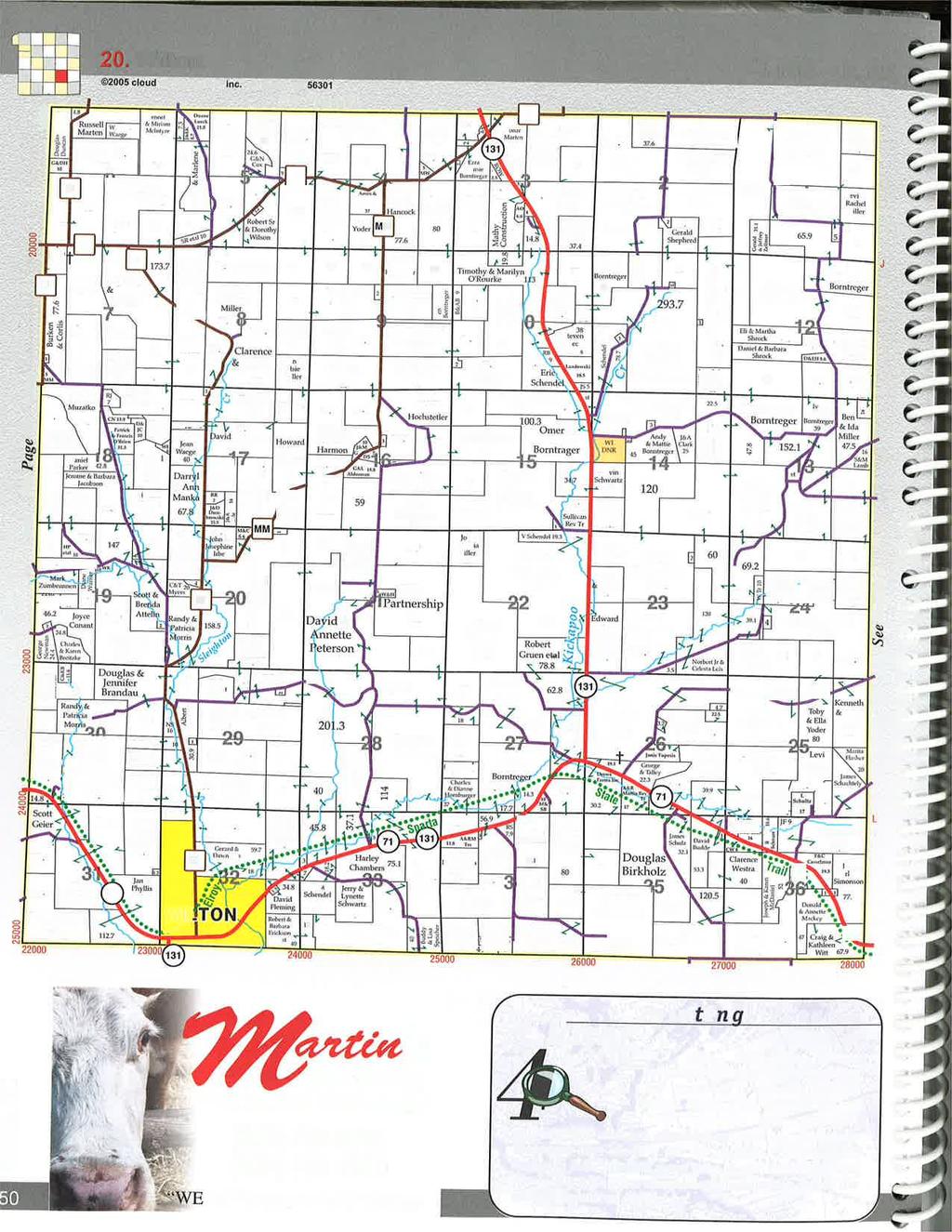
4 NONMETALLIC MINING RECLAMATION For Gerke Excavating Gravel Quarry Town of Wilton Monroe County, Wisconsin May BACKGROUND AND GENERAL INFORMATION 1.1 Description of Project Activity The purpose of this report is to provide a framework for the nonmetallic mining reclamation at the proposed gravel quarry site. The site is located in the Town of Wilton, Monroe County, 7 miles southeast of Tomah. The proposed mining quarry includes existing agricultural lands and wooded areas. 1.2 Project Location The project site is located in the NW 1/4 and NE 1/4 of the NE 1/4 of Section 12, T16N, R1W, Town of Wilton, Monroe County, Wisconsin, containing approximately 60 acres. Said property consists of farm land and steep sloped wooded areas. Figure is USGS location map of the surrounding area. Figure 1.2-1
5 2.0 STATE AND LOCAL REQUIREMENTS Section 2.1 below lists the state nonmetallic mining reclamation requirements; Section 2.2 below lists the local requirements and Section 2.3 is a listing of persons and/or entities receiving this document. 2.1 Wisconsin DNR Requirements (NR 135) Surface Water and Wetland Protection Nonmetallic mining reclamation shall be conducted and completed in a manner that assures compliance with water quality standards for surface waters and wetlands. Necessary measures for diversion and drainage of runoff from the site to prevent pollution of waters of the state shall be installed in accordance with the reclamation plan. Diverted or channelized runoff resulting from reclamation may not adversely affect neighboring properties Groundwater Protection Nonmetallic mining site shall be reclaimed in a manner that does not cause a permanent lowering of the water table that results in adverse effects on surface waters, or a significant reduction in the quantity of groundwater reasonably available for future users of groundwater infiltration Topsoil Management Removal of on-site topsoil material shall be performed prior any mining activity. Once removed, topsoil or topsoil substitute material shall either be used in contemporaneous reclamation or stored in an environmentally acceptable manner. The location of stockpiled topsoil or topsoil substitute material shall be chosen to protect the material from erosion or further disturbance or contamination. Runoff water shall be diverted around all locations in which topsoil or topsoil substitute material is stockpiled Final Grading and Slopes Final grades and slopes shall provide for stable and safe conditions in the post mining land use. Final reclaimed slopes covered by topsoil or topsoil substitute material may not be steeper than a 3:1. When the post mining land use includes a body of water, the approved final grade at the edge of a body of water shall extend vertically 6 feet below the lowest seasonal water level. A slope no steeper than 3:1 shall be created at a designated location or locations, depending on the size of the water body to allow for a safe exit Topsoil Redistribution for Reclamation Topsoil or topsoil substitute material shall be redistributed in accordance with the approved reclamation plan in a manner which minimizes compaction and prevents erosion. Topsoil or topsoil substitute material shall be uniformly redistributed except where uniform redistribution is undesirable or impractical. Topsoil material redistribution may not be performed during or immediately after a precipitation event until the soils have sufficiently dried Revegetation and Site Stabilization Except for permanent roads or similar surfaces, all surfaces affected by nonmetallic mining shall be reclaimed and stabilized by revegetation or other means. Revegetation and site stabilization shall be performed as soon as practicable after GENERAL ENGINEERING COMPANY Nonmetallic Mining Reclamation Gerke Excavating, Town of Wilton, Monroe County, WI 2
6 mining activity has permanently ceased in any part of the mine site Assessing Completion of Successful Reclamation The criteria for assessing when reclamation is complete and, therefore, when the financial assurance may be released shall be specified in the reclamation plan and shall be based on site inspection and report Maintenance During the period of the site reclamation, after the operator has stated that reclamation is complete but prior to release of financial assurance, the operator shall perform any maintenance necessary to prevent erosion, sedimentation or environmental pollution. 2.2 Monroe County Nonmetallic Mining Ordinance 2.3 Submittal List Monroe County Land Conservation Department c/o Bryce Richardson Soil and Water Conservationist Monroe County Land Conservation Dept 820 Industrial Drive Suite 3 Sparta, WI Bryce.Richardson@co.monroe.wi.us Other approving authorities will be copied as needed or requested. 3.0 RECLAMATION PLAN 3.1 Site Information. The proposed mine will contain a gravel quarry located on 60 acres in Monroe County, Wisconsin. The operation will be located approximately 7 miles southeast of city of Tomah, WI. Gravel material is derived from sandstone, pebble conglomerate and shale deposits. The mine is proposed to operate for 6-10 years allowing 1 to 3 years for reclamation. Mining of the unconsolidated deposits will occur in 4 distinct phases. Each separate phase is expected to be about years. Contemporaneous reclamation of phase 2 of the gravel quarry will begin during or immediately preceding the initiation of phase 3. Waste and overburden screens shall be stockpiled to provide a source of backfill material during final reclamation activities Legal Description: Parcels of land located in Section 12, TT16N; R1W; Town of Wilton, Monroe County. Commencing at the NE corner of said Section 12 and also the point of beginning; Thence S00 37'38"E along east line of said Section 12, feet; Thence N88 53'04"W, feet; Thence N88 53'04"W, feet; GENERAL ENGINEERING COMPANY Nonmetallic Mining Reclamation Gerke Excavating, Town of Wilton, Monroe County, WI 3
7 Thence N00 18'20"W to the north line of said Section 12, feet; Thence S89 06'38"E along North line of said Section 12, feet; Thence S89 06'38"E along North line of said Section 12, feet to the point of beginning; Property Boundary Please see attached Maps A1.0 & A Aerial Extent Map B1.0 illustrates how phasing will occur. Mining occurs in phases to minimize disturbance and erosion on the mining site. Each phase corresponds to a specific excavation period where topsoil is removed and the pit is expanded. There are 4 distinct mining phases. Prior any rock extraction, topsoil shall be stripped and relocated to designated stockpile locations. Portions of this topsoil along with waste screens shall be used to reclaim areas excavated during the limestone/gravel excavation. Reclamation efforts shall be contemporaneous starting with Phase 2. For more information on Phasing see Map B Geologic Composition and Depth of Mineral Deposits The site features fairly leveled farmlands on the west and steeped wooded areas to the east. An intermittent stream runs through the wooded areas east from the proposed site. The bedrock geology for this area is described as sandstone, pebble conglomerate and shale, coarse to fine grained, gray to light brown to white, poorly sorted, thin to thick bedded, total thickness reaches 230ft in far west. The portion of the property containing mineable sandstone deposits ranges from 50ft-70ft thickness Distribution, Thickness and Type of Topsoil A variety of soils occur in the area of the proposed mining site. A map delineating the soil types has been included in the reclamation plan (Map A1.5) along with the approximate pre-mining topography. The primary soils encountered on the site are of silt loams nature and include Reedsburg silt loam (RbA, RbB), Wildale cherty silt loam. The majority of the proposed mineable areas fall within farm lands Groundwater Information Wisconsin Geologic and Natural History Survey (WGNHS) provides an overview of the regional groundwater regime. Elevation of groundwater in the area proposed for gravel quarry is approximately 1140 or 280 depth from the existing topography (1420 ). Please refer to Map A1.16 for the approximate elevation of groundwater. The flow direction of groundwater is generally East towards Clifton. The mining operation will be conducted well above the groundwater table Location of Surface Waters DNR surface water viewer depicts only intermittent streams surrounding the proposed mining area. Reclaimed site topography will maintain the drainage pattern to the ephemeral streams generally draining to the east. For more Details see Map A1.2. GENERAL ENGINEERING COMPANY Nonmetallic Mining Reclamation Gerke Excavating, Town of Wilton, Monroe County, WI 4
8 3.1.8 Existing Topography Existing topography has been graphically represented on Map A1.1. Map B1.1 shows the mining site in plan and profile after the reclamation is complete Locations of Manmade Features Please refer to Map A1.1 shows the existing site, Map B1.0 shows the mining site with the proposed manmade features. Proposed manmade features include access road, stockpile locations. 3.2 Post Mining Land Use Gerke Excavating shall return the site to a combination of post-mining land uses including wildlife habitat and prairie agricultural land or pastures. The proposed reclamation plan provides details and final land uses for the entire mining site. Generally, slopes shall be graded to minimum of 3:1 horizontal to vertical ratio. Rock faces may remain as exposed rock where practical. Plant materials will be selected for reclamation based on the post-mining land use. Native species will be used to the extent practicable. 3.3 Reclamation Measures Final Grades and Slopes Gerke Excavating shall re-grade steep slopes and maintain minimum 3:1 slopes where practical, to promote natural lines and blending contour lines to the undisturbed site topography. Mine operator shall use overburden screens and other clean material as backfill against vertical slopes. The proposed mining pit line is curvilinear, thus have more natural appearance. All grading will be completed and resulting surfaces scarified prior to topsoil redistribution, Grading will be competed in a matter of preventing ponding of water on the reclaimed surfaces. The topsoil and subsoil will be placed and finished to the required lines, grades and slopes as shown on Map B Topsoil Management Erosion control measures shall be installed prior any land disturbance activities. Trees, brush and other woody materials removed from the site during grubbing shall be shredded to mulch and stockpile on site. These materials shall be used later in reclamation activities when possible. Large oversized materials or boulders shall be separated and used to control access to site and the construction of screening berms. After completing erosion and sediment control measures and clearing and grubbing the site, but prior commencing mining activities, the top soil and surficial plant growth material shall be removed. Topsoil horizon is estimated to vary between 6 and 12. In all cases top stripping shall be to a minimum of 6. Minor deviations may occur in the field as the site conditions demand. Topsoil removal shall be accomplished by scrappers or bulldozers and haul trucks. When feasible, soil will be removed in a manner to minimize the surface area exposed to erosion at any given time. GENERAL ENGINEERING COMPANY Nonmetallic Mining Reclamation Gerke Excavating, Town of Wilton, Monroe County, WI 5
9 All topsoil removed from the mining site shall be transported to the locations shown on Map B1.0. Topsoil from Phase 1 shall be stockpiled at the lower margins of the phase boundary. This topsoil stockpile will be shaped into an elongated profile and shall be protected in a timely fashion from erosion through revegetation using the specified seed mix in Appendix B1.4 or through use of mulch or other protective measures. Utilizing the specified seed mix will minimize completion with undesirable and aggressive weedy species. Whenever possible and as depicted in the mining and reclamation sequence plan on Map B1.0 the soil removed to prepare a sequential phase of mining shall be immediately redistributed to complete reclamation on the previous phase. In these instances contemporaneous reclamation shall be done to avoid any unnecessary potential loss of topsoil quality and quantity during storage. Topsoil redistribution and site preparation shall be performed to achieve the final topography and drainage patterns as practicable once mining has ceased in a phase of the operation. All grading will be completed and the resulting surfaces scarified prior topsoil redistribution. This will promote good adherence and bonding between the subsoil and the topsoil and improve infiltration and drainage. Grading will be accomplished so to prevent ponding of water on the reclaimed surface. Topsoil shall be placed back to a depth of minimum 6 inches. When compaction of soil is found to be too dense (access roads) to allow for suitable bond, the mining operator shall employ measures to rectify this condition such as disking, chisel plowing, ripping and or scarification. These measures will promote good bonding between the topsoil and underlying materials and will ensure suitable substrate for plant growth and the development of plant root system. All topsoil shall be redistributed into a prepared site. Topsoil redistribution will be performed under dry conditions using appropriate equipment as to minimize compaction. Any clods or lumps present after the topsoil redistribution shall be broken down by the use of harrows, discs or other appropriate equipment in order to provide uniform textured soil Structures Please refer to Map B1.0 for the locations of the access roads and stockpile locations. Any drainage and sediment control structures within the mining area shall be removed once the vegetative cover is sufficiently established to provide equivalent protection Revegetation Plan The revegetation plan includes all activities in support of selecting, obtaining, handling and applying seed or otherwise installing plant materials to fulfill the reclamation plan. Seed and plant materials will be obtained from a licensed nursery that normally works with native prairie and/or wetland plant materials. Seed shall be free of contamination by weedy species. Seed selection shall be based on the reclamation land use (See Appendix B1.4): Mix-2 Wildlife/Grazing Reclaimed areas shall be seeded only after soils have been properly prepared as specified above. Seeding shall be done at any time during the growing season when soil conditions are suitable except between July 1 and August 15, unless permitted by the county representative. Seeding activities will not be carried out immediately following rain, when the ground is too dry or during windy periods. Care will be taken to follow the instructions that are provided by the supplier. GENERAL ENGINEERING COMPANY Nonmetallic Mining Reclamation Gerke Excavating, Town of Wilton, Monroe County, WI 6
10 General seeding methods include: Broadcast Seeding Using Agricultural Equipment applicable for agricultural land use and wildlife/passive recreation). Seeding activities will be carried out using specified equipment and in a manner to avoid soil compaction. The area seeded will not exceed the area that can be mulched on the same day. Seed will be uniformly sown by means of equipment adapted to the purpose. Then the site will be lightly raked or dragged to cover the seed with approximately one-fourth inch of soil. After seeding is complete, the areas will be lightly rolled or compacted by means of suitable equipment to improve seed to soil contact and germination. Following seeding, mulch will be applied uniformly at a rate of between 1 and 1.5 tons per acre. Mulch will be wheat straw, marsh hay or equivalent weed-free mulch. Mulching operations will begin at the top of the slope and proceed downward. The mulch cover will be applied so as to be loose enough to allow some sunlight to penetrate yet thick enough to provide shade and protection from desiccation and raindrop impact and erosion. After spreading on reseeded surfaces mulch will be crimped into the soil by passing over the reclaimed surface with a dull, weighted disk or similar implement. On steep slopes straw or hay mulch will be securely pegged or stapled in place. In lieu of such anchorage, the mulch may be secured by means of heavy biodegradable twine fastened with pegs or staples to form a grid. Also, at the discretion of the project manager erosion blanket, jute netting or a tactifier may be used in addition to or in lieu of the crimping process Revegetation Standards The purpose of establishing clear revegetation surface criteria is necessary to provide a reference point to evaluate the success of the reclamation operation in an objective manner. Suggested revegetation standards are listed below: Post mining Land Use and Success criteria Table Post Mining Land Use Seed Mix Stage Phase Success Criteria Years to Show Wildlife #2 Final Reclamation 70% cover 2 Percent cover shall be determined by estimating the percentage of an area covered by vegetation and a predictor of site stability. A typical standard for percent cover is 70% cover (primarily leaf and stem area) averaged over the site at 90 percent statistical confidence level. Count may be physical and photos shall be provided. The measurement of cover should be timed to correspond with the period of peak vegetative growth, generally in August. Upon completion of reclamation activities, whether this includes a portion of the site or the entire mining site, the Monroe County Land Conservation Specialist or other relevant regulatory authority shall inspect the site in order to verify success of reclamation Erosion Control The main purpose of a general erosion control plan is to minimize erosion and limit the potential for sediment run-off into surface waters. Erosion control measures will be established prior to any site development activities including soil removal and stockpiling. Erosion control measures will be also established prior to initiating reclamation such as contemporaneous reclamation, backfilling or grading. Typical erosion control measures are shown on Map B1.2 and B1.3. Surface water runoff within mining areas shall be treated within detention ponds and settling basins prior living the site. Protection measures will be installed and maintained to support reclamation activities for each phase of the mine and will be in place before and during contemporaneous reclamation. Mining GENERAL ENGINEERING COMPANY Nonmetallic Mining Reclamation Gerke Excavating, Town of Wilton, Monroe County, WI 7
11 will be completed in phases along with concurrent reclamation, therefore effectively lowering the risk of erosion to few simultaneously opened sites. Given the terrain topography temporary detention basins shall be constructed at the downstream end of each mining phase and shall effectively treat the storm runoff to meet NR 151 criteria, subject to separate stormwater management plan. A main element of this reclamation plan is staging the acreage being mined at any given time. This approach, along with concurrent final and interim reclamation, will minimize the total area exposed to erosion in accordance with NR Once area is stabilized Gerke Excavating shall request that the Monroe County Land Conservation Office consider the increment temporarily reclaimed for the purpose of reduction of fees under NR Site Maintenance Mining operator shall inspect the sediment and erosion control systems on a regular basis and immediately after severe storms. Periodic follow-up inspections of all reclaimed or otherwise stabilized surfaces shall be performed to ensure they are in a condition stable enough to control erosion and sedimentation. When damage caused by traffic, wind, water or other cause is detected the mining operator will promptly perform all necessary maintenance and repair work to the erosion control system. Likewise, other work necessary to ensure long term success of the vegetation including follow-up fertilization, necessary soil amendments or any weed or pest control will be accomplished. As part of maintenance of the reclaimed site, Gerke Excavating will perform any necessary weed control or pest control and maintenance both to facilitate the establishment and survival of vegetation. Exotic species that occur on the site or are accidentally added though contaminants in the seed mixes or through the use of hay or other mulch products that are not weed free will be promptly controlled through fire, mechanical means or with herbicides. This is especially true when the species appears on the list of state noxious weeds. This will continue until the Monroe County Land Conservation Office issues the certificate of completion (COC). 3.4 Criteria for Successful Reclamation Gerke Excavating shall demonstrate compliance with the revegetation success standards (performance standards) for each post-mining land use contained in the reclamation plan. The techniques employed are as follows: percent cover will be determined as total cover (expressed as a percentage) as measured by coverage of the canopy (vertical projection of plant parts) and will be recorded by species. Cover will be measured over the entire re-vegetated site at no less than 20 randomly placed 10 square feet quadrats for each 10 acre area. Success criteria will vary with the post-mining land use. In addition, both presence (a species list) and frequency (number of quadrats the species occurs in) will be included. 3.5 Certification of the Reclamation Plan Certification is included within the Monroe County Application for Reclamation Permit for New or Reopened Nonmetallic Mining Sites. Please see Appendix C 3.6 Final Site Actions The final removal of mining-related structures, drainage structures and sediment control structures will be accomplished once the vegetative cover is robust enough to provide equivalent protection. At such time and in accordance with the approved reclamation plan those structures will be GENERAL ENGINEERING COMPANY Nonmetallic Mining Reclamation Gerke Excavating, Town of Wilton, Monroe County, WI 8
12 removed and the soils in such areas will be reclaimed. At this time Gerke Excavating shall request the Monroe County Land Conservation Department to perform the necessary inspection and evaluation work to certify the reclamation as complete (COC) and to release the financial assurance. 3.7 Certification of the Reclamation Plan I hereby certify, as a duly authorized representative or agent, that Gerke Excavating, shall comply with the provisions of this reclamation plan as well as the statewide nonmetallic mining reclamation standards established in ss. NR through NR , Wis. Adm. Code. Signature of Applicant or Duly Authorized Agent Date Signed Owner and/or Lessee: Joe L. Borntreger, I,, certify that I concur with the reclamation plan submitted and will allow its implementation. 3.8 Financial Assurance The objective of financial assurance is to ensure that the Monroe County Land Conservation Department has access to funds necessary to implement site reclamation in the event that the operator does not perform the agreed upon duties. The funds shall accurately reflect the cost for the regulatory authority to hire outside help to perform reclamation. The main purpose of financial assurance is to ensure that the operator will faithfully execute the requirements of the approved reclamation plan, the applicable reclamation ordinance and Ch. NR 135. Gerke Excavating, is estimating $2, per acre for reclamation purposes. The total amount of financial assurance shall be based on the actual disturbed acreages of land and not on the overall mining area. The length of the financial assurance is dictated by the period of time required to establish the post mining land use specified in the mine reclamation plan. Any interest from the financial assurance shall be paid to the operator per NR (4) The amount of financial assurance is reviewed periodically by the Monroe County Land Conservation Department to assure it equals outstanding reclamation costs. Upon approval the proposed amount, the mining operator shall establish a bond, net worth test, escrow account or an alternate option to cover the financial assurance. GENERAL ENGINEERING COMPANY Nonmetallic Mining Reclamation Gerke Excavating, Town of Wilton, Monroe County, WI 9
13 APPENDIX A

14

15 LEGAL DESCRIPTION (PROPOSED MINING AREA): Located in the NW 1 4 and NE 1 4 of NE 1 4 of Section 12, T16N, R1W, Town of Wilton, Monroe County, Wisconsin Commencing at the NE corner of said Section 12 and also the point of beginning; Thence S00 37'38"E along east line of said Section 12, feet; Thence N88 53'04"W, feet; Thence N88 53'04"W, feet; Thence N00 18'20"W to the north line of said Section 12, feet; Thence S89 06'38"E along North line of said Section 12, feet; Thence S89 06'38"E along North line of said Section 12, feet to point of beginning. KK iiinn g gr d d Kiiin K ng gr Rd d Rd d gr K Kiin in ng JOE L. BORNTREGER KING RD WILTON, WI AMOS A. MILLER KING RD WILTON,, WI JOE L. BORNTREGER KING RD WILTON, WI WEBER-REIS FAMILY LIMITED PARTNERSHIP JULIETTE AVE TOMAH, WI ' ' ' WEBER-REIS FAMILY LIMITED PARTNERSHIP JULIETTE AVE TOMAH, WI JOE L. BORNTREGER KING RD WILTON, WI JOE L. BORNTREGER KING RD WILTON, WI JOANN L. SHATTUCK JUDITH AVE WILTON, WI INTERMITTENT CREEK d Rd gr ng Kiin ' ' JJu ud ud diiitth ha Avve e Town of Wilton Monroe County, WI ' Gravel Quarry Gerke Excavating ' LEGAL DESCRIPTION MAP Kiiin ng gr Rd d WEBER-REIS FAMILY LIMITED PARTNERSHIP JULIETTE AVE TOMAH, WI N W E S 1200 SCALE DATE SSR May, 2012 GEC FILE NO D DRAWN BY JOANN L. SHATTUCK JUDITH AVE WILTON, WI JOANN L. SHATTUCK JUDITH AVE WILTON, WI Kiin ng gr Rd JOANN L. SHATTUCK JUDITH AVE WILTON, WI SHEET NO. A1.1
16 DNR Surface Waters Project Location ft. This map is a user generated static output from an Internet mapping site and is for general reference only. Data layers that appear on this map may or may not be accurate, current, or otherwise reliable. THIS MAP IS NOT TO BE USED FOR NAVIGATION. Legend Scale: 1:13,755 A1.2

17 WI DNR Wetland Inventory Map Project Location ft. This map is a user generated static output from an Internet mapping site and is for general reference only. Data layers that appear on this map may or may not be accurate, current, or otherwise reliable. THIS MAP IS NOT TO BE USED FOR NAVIGATION. Legend Scale: 1:13,755 A1.3

18 WISLAND Landcover Legend ft. Scale: 1:13,755 This map is a user generated static output from an Internet mapping site and is for general reference only. Data layers that appear on this map may or may not be accurate, current, or otherwise reliable. THIS MAP IS NOT TO BE USED FOR NAVIGATION.
 sheet.")
19 (Gravel Quarry) 43 53' 10'' 43 52' 52'' ' 34'' 90 26' 33'' Judith Ave ± King Rd RbA WdB WdB WdC2 WdC2 RbB Map Scale: 1:4,040 if printed on A size (8.5" x 11") sheet Meters ,200 Feet WdD2 Pd WdC Pd Pd NuF ' 55'' 90 25' 56'' ' 9'' 43 52' 51'' Natural Resources Conservation Service Web Soil Survey National Cooperative Soil Survey Wisconsin County, Map Monroe Soil 5/3/2012 Page 1 of 3
20 Soil Map Monroe County, Wisconsin (Gravel Quarry) MAP LEGEND MAP INFORMATION Area of Interest (AOI) Area of Interest (AOI) Soils Soil Map Units Special Point Features Blowout Borrow Pit Clay Spot Closed Depression Gravel Pit Gravelly Spot Landfill Lava Flow Marsh or swamp Mine or Quarry Miscellaneous Water Perennial Water Rock Outcrop Saline Spot Sandy Spot Severely Eroded Spot Sinkhole Slide or Slip Sodic Spot Spoil Area Stony Spot Very Stony Spot Wet Spot Other Special Line Features Gully Short Steep Slope Other Political Features Cities Water Features Streams and Canals Transportation Rails Interstate Highways US Routes Major Roads Local Roads Map Scale: 1:4,040 if printed on A size (8.5" 11") sheet. The soil surveys that comprise your AOI were mapped at 1:15,840. Warning: Soil Map may not be valid at this scale. Enlargement of maps beyond the scale of mapping can cause misunderstanding of the detail of mapping and accuracy of soil line placement. The maps do not show the small areas of contrasting soils that could have been shown at a more detailed scale. Please rely on the bar scale on each map sheet for accurate map measurements. Source of Map: Natural Resources Conservation Service Web Soil Survey URL: Coordinate System: UTM Zone 15N NAD83 This product is generated from the USDA-NRCS certified data as of the version date(s) listed below. Soil Survey Area: Monroe County, Wisconsin Survey Area Data: Version 7, May 13, 2009 Date(s) aerial images were photographed: 6/18/2005; 8/1/2005 The orthophoto or other base map on which the soil lines were compiled and digitized probably differs from the background imagery displayed on these maps. As a result, some minor shifting of map unit boundaries may be evident. Natural Resources Conservation Service Web Soil Survey National Cooperative Soil Survey 5/3/2012 Page 2 of 3
21 Soil Map Monroe County, Wisconsin Gravel Quarry Map Unit Legend Monroe County, Wisconsin (WI081) Map Unit Symbol Map Unit Name Acres in AOI Percent of AOI NuF Norden, Urne, and Dorerton soils, 20 to 45 percent slopes % Pd Pits % RbA Reedsburg silt loam, 0 to 2 percent slopes % RbB Reedsburg silt loam, 2 to 6 percent slopes % WdB Wildale silt loam, 2 to 6 percent slopes % WdC2 WdD2 Wildale cherty silt loam, 6 to 12 percent slopes, eroded Wildale cherty silt loam, 12 to 20 percent slopes, eroded % % Totals for Area of Interest % Natural Resources Conservation Service Web Soil Survey National Cooperative Soil Survey 5/3/2012 Page 3 of 3
22 Map Unit Description Monroe County, Wisconsin Gravel Quarry Map Unit Description The map units delineated on the detailed soil maps in a soil survey represent the soils or miscellaneous areas in the survey area. The map unit descriptions in this report, along with the maps, can be used to determine the composition and properties of a unit. A map unit delineation on a soil map represents an area dominated by one or more major kinds of soil or miscellaneous areas. A map unit is identified and named according to the taxonomic classification of the dominant soils. Within a taxonomic class there are precisely defined limits for the properties of the soils. On the landscape, however, the soils are natural phenomena, and they have the characteristic variability of all natural phenomena. Thus, the range of some observed properties may extend beyond the limits defined for a taxonomic class. Areas of soils of a single taxonomic class rarely, if ever, can be mapped without including areas of other taxonomic classes. Consequently, every map unit is made up of the soils or miscellaneous areas for which it is named and some minor components that belong to taxonomic classes other than those of the major soils. Most minor soils have properties similar to those of the dominant soil or soils in the map unit, and thus they do not affect use and management. These are called noncontrasting, or similar, components. They may or may not be mentioned in a particular map unit description. Other minor components, however, have properties and behavioral characteristics divergent enough to affect use or to require different management. These are called contrasting, or dissimilar, components. They generally are in small areas and could not be mapped separately because of the scale used. Some small areas of strongly contrasting soils or miscellaneous areas are identified by a special symbol on the maps. If included in the database for a given area, the contrasting minor components are identified in the map unit descriptions along with some characteristics of each. A few areas of minor components may not have been observed, and consequently they are not mentioned in the descriptions, especially where the pattern was so complex that it was impractical to make enough observations to identify all the soils and miscellaneous areas on the landscape. The presence of minor components in a map unit in no way diminishes the usefulness or accuracy of the data. The objective of mapping is not to delineate pure taxonomic classes but rather to separate the landscape into landforms or landform segments that have similar use and management requirements. The delineation of such segments on the map provides sufficient information for the development of resource plans. If intensive use of small areas is planned, however, onsite investigation is needed to define and locate the soils and miscellaneous areas. An identifying symbol precedes the map unit name in the map unit descriptions. Each description includes general facts about the unit and gives important soil properties and qualities. Natural Resources Conservation Service Web Soil Survey National Cooperative Soil Survey 5/3/2012 Page 1 of 8
23 Map Unit Description Monroe County, Wisconsin Gravel Quarry Soils that have profiles that are almost alike make up a soil series. All the soils of a series have major horizons that are similar in composition, thickness, and arrangement. Soils of a given series can differ in texture of the surface layer, slope, stoniness, salinity, degree of erosion, and other characteristics that affect their use. On the basis of such differences, a soil series is divided into soil phases. Most of the areas shown on the detailed soil maps are phases of soil series. The name of a soil phase commonly indicates a feature that affects use or management. For example, Alpha silt loam, 0 to 2 percent slopes, is a phase of the Alpha series. Some map units are made up of two or more major soils or miscellaneous areas. These map units are complexes, associations, or undifferentiated groups. A complex consists of two or more soils or miscellaneous areas in such an intricate pattern or in such small areas that they cannot be shown separately on the maps. The pattern and proportion of the soils or miscellaneous areas are somewhat similar in all areas. Alpha-Beta complex, 0 to 6 percent slopes, is an example. An association is made up of two or more geographically associated soils or miscellaneous areas that are shown as one unit on the maps. Because of present or anticipated uses of the map units in the survey area, it was not considered practical or necessary to map the soils or miscellaneous areas separately. The pattern and relative proportion of the soils or miscellaneous areas are somewhat similar. Alpha-Beta association, 0 to 2 percent slopes, is an example. An undifferentiated group is made up of two or more soils or miscellaneous areas that could be mapped individually but are mapped as one unit because similar interpretations can be made for use and management. The pattern and proportion of the soils or miscellaneous areas in a mapped area are not uniform. An area can be made up of only one of the major soils or miscellaneous areas, or it can be made up of all of them. Alpha and Beta soils, 0 to 2 percent slopes, is an example. Some surveys include miscellaneous areas. Such areas have little or no soil material and support little or no vegetation. Rock outcrop is an example. Additional information about the map units described in this report is available in other soil reports, which give properties of the soils and the limitations, capabilities, and potentials for many uses. Also, the narratives that accompany the soil reports define some of the properties included in the map unit descriptions. Report Map Unit Description Monroe County, Wisconsin NuF Norden, Urne, and Dorerton soils, 20 to 45 percent slopes Map Unit Setting Elevation: 800 to 1,400 feet Mean annual precipitation: 28 to 33 inches Mean annual air temperature: 46 to 52 degrees F Frost-free period: 135 to 160 days Map Unit Composition Norden and similar soils: 40 percent Natural Resources Conservation Service Web Soil Survey National Cooperative Soil Survey 5/3/2012 Page 2 of 8
24 Map Unit Description Monroe County, Wisconsin Gravel Quarry Natural Resources Conservation Service Urne and similar soils: 30 percent Dorerton and similar soils: 15 percent Description of Norden Setting Landform: Hills Landform position (two-dimensional): Summit, shoulder, backslope Down-slope shape: Convex Across-slope shape: Convex Parent material: Loess over loamy residuum weathered from glauconitic sandstone Properties and qualities Slope: 20 to 45 percent Depth to restrictive feature: 20 to 40 inches to paralithic bedrock Drainage class: Well drained Capacity of the most limiting layer to transmit water (Ksat): Moderately low to high (0.14 to 1.98 in/hr) Depth to water table: More than 80 inches Frequency of flooding: None Frequency of ponding: None Available water capacity: Low (about 5.5 inches) Interpretive groups Land capability (nonirrigated): 7e Typical profile 0 to 3 inches: Loam 3 to 10 inches: Loam 10 to 29 inches: Loam 29 to 60 inches: Unweathered bedrock Description of Urne Setting Landform: Hills Landform position (two-dimensional): Shoulder, summit, backslope Down-slope shape: Convex Across-slope shape: Convex Parent material: Loamy residuum weathered from glauconitic sandstone Properties and qualities Slope: 20 to 45 percent Depth to restrictive feature: 20 to 40 inches to paralithic bedrock Drainage class: Somewhat excessively drained Capacity of the most limiting layer to transmit water (Ksat): Moderately low to high (0.14 to 1.98 in/hr) Depth to water table: More than 80 inches Frequency of flooding: None Frequency of ponding: None Available water capacity: Low (about 4.3 inches) Interpretive groups Land capability (nonirrigated): 7e Web Soil Survey National Cooperative Soil Survey 5/3/2012 Page 3 of 8
25 Map Unit Description Monroe County, Wisconsin Gravel Quarry Typical profile 0 to 2 inches: Fine sandy loam 2 to 32 inches: Very fine sandy loam 32 to 38 inches: Very fine sandy loam 38 to 60 inches: Weathered bedrock Description of Dorerton Setting Landform: Hills Landform position (two-dimensional): Backslope, shoulder, summit Down-slope shape: Convex Across-slope shape: Convex Parent material: Loess over loamy residuum Properties and qualities Slope: 20 to 45 percent Depth to restrictive feature: 45 to 70 inches to lithic bedrock Drainage class: Well drained Capacity of the most limiting layer to transmit water (Ksat): Moderately high to high (0.57 to 1.98 in/hr) Depth to water table: More than 80 inches Frequency of flooding: None Frequency of ponding: None Available water capacity: Moderate (about 7.9 inches) Interpretive groups Land capability (nonirrigated): 7e Typical profile 0 to 4 inches: Silt loam 4 to 21 inches: Loam 21 to 56 inches: Channery loam 56 to 60 inches: Very channery loamy sand Pd Pits Map Unit Setting Mean annual precipitation: 28 to 33 inches Mean annual air temperature: 46 to 52 degrees F Frost-free period: 135 to 160 days Map Unit Composition Pits: 100 percent Description of Pits Interpretive groups Land capability (nonirrigated): 8s Natural Resources Conservation Service Web Soil Survey National Cooperative Soil Survey 5/3/2012 Page 4 of 8
26 Map Unit Description Monroe County, Wisconsin Gravel Quarry RbA Reedsburg silt loam, 0 to 2 percent slopes Map Unit Setting Elevation: 800 to 1,300 feet Mean annual precipitation: 28 to 33 inches Mean annual air temperature: 46 to 52 degrees F Frost-free period: 135 to 160 days Map Unit Composition Reedsburg and similar soils: 100 percent Description of Reedsburg Setting Landform: Hills Landform position (two-dimensional): Summit Down-slope shape: Convex Across-slope shape: Linear Parent material: Loess over clayey residuum weathered from dolomite Properties and qualities Slope: 0 to 2 percent Depth to restrictive feature: More than 80 inches Drainage class: Somewhat poorly drained Capacity of the most limiting layer to transmit water (Ksat): Very low to moderately low (0.00 to 0.14 in/hr) Depth to water table: About 12 to 36 inches Frequency of flooding: None Frequency of ponding: None Available water capacity: Moderate (about 8.0 inches) Interpretive groups Land capability (nonirrigated): 2w Typical profile 0 to 8 inches: Silt loam 8 to 27 inches: Silt loam 27 to 60 inches: Clay Minor Components Aqualfs, poorly drained Percent of map unit: Landform: Depressions, drainageways RbB Reedsburg silt loam, 2 to 6 percent slopes Map Unit Setting Elevation: 800 to 1,300 feet Mean annual precipitation: 28 to 33 inches Mean annual air temperature: 46 to 52 degrees F Frost-free period: 135 to 160 days Natural Resources Conservation Service Web Soil Survey National Cooperative Soil Survey 5/3/2012 Page 5 of 8
27 Map Unit Description Monroe County, Wisconsin Gravel Quarry Map Unit Composition Reedsburg and similar soils: 100 percent Description of Reedsburg Setting Landform: Hills Landform position (two-dimensional): Summit Down-slope shape: Convex Across-slope shape: Convex Parent material: Loess over clayey residuum weathered from dolomite Properties and qualities Slope: 2 to 6 percent Depth to restrictive feature: More than 80 inches Drainage class: Somewhat poorly drained Capacity of the most limiting layer to transmit water (Ksat): Very low to moderately low (0.00 to 0.14 in/hr) Depth to water table: About 12 to 36 inches Frequency of flooding: None Frequency of ponding: None Available water capacity: Moderate (about 8.0 inches) Interpretive groups Land capability (nonirrigated): 2e Typical profile 0 to 8 inches: Silt loam 8 to 27 inches: Silt loam 27 to 60 inches: Clay WdB Wildale silt loam, 2 to 6 percent slopes Map Unit Setting Mean annual precipitation: 28 to 33 inches Mean annual air temperature: 46 to 52 degrees F Frost-free period: 135 to 160 days Map Unit Composition Wildale and similar soils: 100 percent Description of Wildale Setting Landform: Hills Landform position (two-dimensional): Summit Down-slope shape: Convex Across-slope shape: Convex Parent material: Loess over clayey residuum weathered from dolomite Properties and qualities Slope: 2 to 6 percent Natural Resources Conservation Service Web Soil Survey National Cooperative Soil Survey 5/3/2012 Page 6 of 8
28 Map Unit Description Monroe County, Wisconsin Gravel Quarry Depth to restrictive feature: More than 80 inches Drainage class: Well drained Capacity of the most limiting layer to transmit water (Ksat): Very low to moderately low (0.00 to 0.14 in/hr) Depth to water table: More than 80 inches Frequency of flooding: None Frequency of ponding: None Available water capacity: Moderate (about 6.1 inches) Interpretive groups Land capability (nonirrigated): 2e Typical profile 0 to 9 inches: Silt loam 9 to 15 inches: Silty clay loam 15 to 60 inches: Clay WdC2 Wildale cherty silt loam, 6 to 12 percent slopes, eroded Map Unit Setting Mean annual precipitation: 28 to 33 inches Mean annual air temperature: 46 to 52 degrees F Frost-free period: 135 to 160 days Map Unit Composition Wildale and similar soils: 100 percent Description of Wildale Setting Landform: Hills Landform position (two-dimensional): Summit Down-slope shape: Convex Across-slope shape: Convex Parent material: Loess over clayey residuum weathered from dolomite Properties and qualities Slope: 6 to 12 percent Depth to restrictive feature: More than 80 inches Drainage class: Well drained Capacity of the most limiting layer to transmit water (Ksat): Very low to moderately low (0.00 to 0.14 in/hr) Depth to water table: More than 80 inches Frequency of flooding: None Frequency of ponding: None Available water capacity: Moderate (about 6.1 inches) Interpretive groups Land capability (nonirrigated): 3e Typical profile 0 to 9 inches: Silt loam 9 to 15 inches: Silty clay loam 15 to 60 inches: Clay Natural Resources Conservation Service Web Soil Survey National Cooperative Soil Survey 5/3/2012 Page 7 of 8
29 Map Unit Description Monroe County, Wisconsin Gravel Quarry WdD2 Wildale cherty silt loam, 12 to 20 percent slopes, eroded Map Unit Setting Mean annual precipitation: 28 to 33 inches Mean annual air temperature: 46 to 52 degrees F Frost-free period: 135 to 160 days Map Unit Composition Wildale and similar soils: 100 percent Description of Wildale Setting Landform: Hills Landform position (two-dimensional): Summit, shoulder Down-slope shape: Convex Across-slope shape: Convex Parent material: Loess over clayey residuum weathered from dolomite Properties and qualities Slope: 12 to 20 percent Depth to restrictive feature: More than 80 inches Drainage class: Well drained Capacity of the most limiting layer to transmit water (Ksat): Very low to moderately low (0.00 to 0.14 in/hr) Depth to water table: More than 80 inches Frequency of flooding: None Frequency of ponding: None Available water capacity: Moderate (about 6.1 inches) Interpretive groups Land capability (nonirrigated): 4e Typical profile 0 to 9 inches: Silt loam 9 to 15 inches: Silty clay loam 15 to 60 inches: Clay Data Source Information Soil Survey Area: Monroe County, Wisconsin Survey Area Data: Version 7, May 13, 2009 Natural Resources Conservation Service Web Soil Survey National Cooperative Soil Survey 5/3/2012 Page 8 of 8
30
31 APPENDIX B

32 MINING PHASES PHASE 1 1. STRIP AND PILE OVERBURDEN TO PHASE 2 MARGINS. APPLY SEEDING TO BERM TO STABILIZE BANKS AND PREVENT EROSION. 2. INITIATE EXCAVATION IN THIS AREA. 3. EXCAVATE IN DIRECTION INDICATED BY 4. STOCKPILE OVERBURDEN IN DESIGNATED AREAS King Kiing Rd OVERBURDEN STOCKPILE PHASE 2 1. EXTEND EXCAVATION 1. STOCKPILE TOPSOIL IN AREAS AS INDICATED. APPLY SEEDING TO TOPSOIL. 2. BEGIN CONTEMPORANEOUS RECLAMATION IN PHASE 1, RE-SPREAD OVERBURDEN AND MIN OF 6" OF TOPSOIL, APPLY SEEDING. Kiing Rd King Rd ACCESS ROAD PHASE 3 1. EXTEND EXCAVATION. 2. BEGIN RECLAMATION IN PHASE 2. SPREAD WASTE SCREENS AND OVERBURDEN AND SEED PHASE 2 AREA MARGINS. PHASE 4 1. EXTEND EXCAVATION. 2. MOVE OVERBURDEN INTO PHASE 3. BEGIN SHAPING PROPOSED FINAL GRADES IN PHASE 3. BEGIN SEEDING OPERATION ON PHASE 3 MARGINS POST MINING PHASE 1. WHEN MINING PHASE 4 IS COMPLETED, BEGIN SHAPING FINAL PHASE MARGINS AND SEED OPERATION IN PHASE REMOVE ANY ACCESSORY BUILDINGS AND ACCESSORY ROADS. King Kiing Rd ROCK FACES TO REMAIN AS EXPOSED ROCK. SLOPES WILL E GRADED TO 3:1 OR FLATTER WHERE PRACTICAL. PHASE AC PHASE AC INTERMITTENT CREEK OVERBURDEN STOCKPILE. MINING PHASES Gravel Quarry Gerke Excavating Town of Wilton Monroe County, WI K iing Rd King Rd PHASE AC PHASE AC Judiith Ave Judith Ave N 1400 W E OVERBURDEN STOCKPILE. S SCALE K iing Rd King Rd DRAWN BY SSR DATE May, GEC FILE NO D SHEET NO. B1.0

33 1420 Rd King Kiing ROCK FACES TO REMAIN AS EXPOSED ROCK. SLOPES WILL E GRADED TO 3:1 OR FLATTER WHERE PRACTICAL Rd King Kiing INTERMITTENT CREEK FINAL GRADING AND SLOPES Gravel Quarry Gerke Excavating Town of Wilton Monroe County, WI Judiith Ave Judith Ave K iing Rd King Rd ROCK FACES TO REMAIN AS EXPOSED ROCK. SLOPES WILL E GRADED TO 3:1 OR FLATTER WHERE PRACTICAL N 1340 MIN. 1.0% W E 1320 S 1300 SCALE 1280 DRAWN BY DATE GEC FILE NO. SSR May, D SHEET NO. B1.1
 108 40' 29'' W Soil Map Mesa County Area, Colorado 108 36' 55'' W 39 10' 11'' N 39 6' 31'' N 4331700 4332500 4333300 4334100 4334900 4335700 4336500 4337300 4338100 701100 701900 702700 703500 704300 705100
Custom Soil Resource Report for Craighead County, Arkansas
 United States Department of Agriculture Natural Resources Conservation Service A product of the National Cooperative Soil Survey, a joint effort of the United States Department of Agriculture and other
Custom Soil Resource Report for Fond du Lac County, Wisconsin
 United States Department of Agriculture Natural Resources Conservation Service A product of the National Cooperative Soil Survey, a joint effort of the United States Department of Agriculture and other
Custom Soil Resource Report for Pope County, Illinois
 United States Department of Agriculture Natural Resources Conservation Service A product of the National Cooperative Soil Survey, a joint effort of the United States Department of Agriculture and other
Custom Soil Resource Report for Pope County, Illinois
 United States Department of Agriculture Natural Resources Conservation Service A product of the National Cooperative Soil Survey, a joint effort of the United States Department of Agriculture and other
Custom Soil Resource Report for Daviess County, Missouri
 United States Department of Agriculture Natural Resources Conservation Service A product of the National Cooperative Soil Survey, a joint effort of the United States Department of Agriculture and other
Non-Metallic Mining Reclamation Checklist
 Eau Claire County DEPARTMENT OF PLANNING AND DEVELOPMENT Eau Claire County Courthouse, Rm. 1510 721 Oxford Avenue Eau Claire, Wisconsin 54703-5481 (715) 839-4741 f Housing & Community Development 839-6240
NRCS Soils Report. Encana Oil & Gas (USA) Inc. C19 Injection Well. OA Project No
 Inc. C19 Injection Well. OA Project No") NRCS Soils Report Encana Oil & Gas (USA) Inc. C19 Injection Well OA Project No. 012-0178 826 21 ½ Road Grand Junction, CO 81505 TEL 970.263.7800 FAX 970.263.7456 United States Department of Agriculture
NRCS Soils Report Encana Oil & Gas (USA) Inc. C19 Injection Well OA Project No. 012-0178 826 21 ½ Road Grand Junction, CO 81505 TEL 970.263.7800 FAX 970.263.7456 United States Department of Agriculture
Custom Soil Resource Report for Kane County, Illinois
 United States Department of Agriculture Natural Resources Conservation Service A product of the National Cooperative Soil Survey, a joint effort of the United States Department of Agriculture and other
Custom Soil Resource Report for State of Connecticut
 United States Department of Agriculture Natural Resources Conservation Service A product of the National Cooperative Soil Survey, a joint effort of the United States Department of Agriculture and other
Custom Soil Resource Report for Lane County Area, Oregon
 United States Department of Agriculture Natural Resources Conservation Service A product of the National Cooperative Soil Survey, a joint effort of the United States Department of Agriculture and other
Custom Soil Resource Report for Polk County, Oregon
 United States Department of Agriculture Natural Resources Conservation Service A product of the National Cooperative Soil Survey, a joint effort of the United States Department of Agriculture and other
Custom Soil Resource Report for Kent County, Maryland
 United States Department of Agriculture Natural Resources Conservation Service A product of the National Cooperative Soil Survey, a joint effort of the United States Department of Agriculture and other
Custom Soil Resource Report for Southampton County, Virginia
 United States Department of Agriculture Natural Resources Conservation Service A product of the National Cooperative Soil Survey, a joint effort of the United States Department of Agriculture and other
Custom Soil Resource Report for Yamhill Area, Oregon
 United States Department of Agriculture Natural Resources Conservation Service A product of the National Cooperative Soil Survey, a joint effort of the United States Department of Agriculture and other
Custom Soil Resource Report for Clark County, Missouri
 United States Department of Agriculture Natural Resources Conservation Service A product of the National Cooperative Soil Survey, a joint effort of the United States Department of Agriculture and other
Custom Soil Resource Report for Franklin County, Washington
 United States Department of Agriculture Natural Resources Conservation Service A product of the National Cooperative Soil Survey, a joint effort of the United States Department of Agriculture and other
Custom Soil Resource Report for Polk County, Oregon
 United States Department of Agriculture Natural Resources Conservation Service A product of the National Cooperative Soil Survey, a joint effort of the United States Department of Agriculture and other
Custom Soil Resource Report for Choctaw County, Oklahoma, and McCurtain County, Oklahoma
 United States Department of Agriculture Natural Resources Conservation Service A product of the National Cooperative Soil Survey, a joint effort of the United States Department of Agriculture and other
Custom Soil Resource Report for Orange County, Virginia
 United States Department of Agriculture Natural Resources Conservation Service A product of the National Cooperative Soil Survey, a joint effort of the United States Department of Agriculture and other
Custom Soil Resource Report for Payne County, Oklahoma
 United States Department of Agriculture Natural Resources Conservation Service A product of the National Cooperative Soil Survey, a joint effort of the United States Department of Agriculture and other
Custom Soil Resource Report for Hamilton County, Texas
 United States Department of Agriculture Natural Resources Conservation Service A product of the National Cooperative Soil Survey, a joint effort of the United States Department of Agriculture and other
Custom Soil Resource Report for Ulster County, New York
 United States Department of Agriculture Natural Resources Conservation Service A product of the National Cooperative Soil Survey, a joint effort of the United States Department of Agriculture and other
NRCS Soils Report. Grand River Gathering LLC K28E Compressor Station. OA Project No
 NRCS Soils Report Grand River Gathering LLC K28E Compressor Station OA Project No. 012-032 82 21 ½ Road Grand Junction, CO 81505 TEL 90.23.800 FAX 90.23.45 United States Department of Agriculture A product
Custom Soil Resource Report for Hancock County Area, Maine
 United States Department of Agriculture Natural Resources Conservation Service A product of the National Cooperative Soil Survey, a joint effort of the United States Department of Agriculture and other
Custom Soil Resource Report for Walker County, Texas
 United States Department of Agriculture Natural Resources Conservation Service A product of the National Cooperative Soil Survey, a joint effort of the United States Department of Agriculture and other
Custom Soil Resource Report for Centre County, Pennsylvania
 United States Department of Agriculture Natural Resources Conservation Service A product of the National Cooperative Soil Survey, a joint effort of the United States Department of Agriculture and other
MONROE COUNTY PROPOSED RECLAMATION PLAN
 MONROE COUNTY PROPOSED RECLAMATION PLAN SITE NAME: Purpus Quarry GENERAL INFORMATION: Operator Name/Address: The Kraemer Company, LLC 820 Wachter Avenue P.O. Box 235 Plain, Wisconsin 53577 (608) 546-2255
Custom Soil Resource Report for Banks and Stephens Counties, Georgia
 United States Department of Agriculture Natural Resources Conservation Service A product of the National Cooperative Soil Survey, a joint effort of the United States Department of Agriculture and other
Custom Soil Resource Report for McCurtain County, Oklahoma
 United States Department of Agriculture Natural Resources Conservation Service A product of the National Cooperative Soil Survey, a joint effort of the United States Department of Agriculture and other
~ NRCS. Custom Soil Resource Report for Rifle Area, Colorado, Parts of Garfield and Mesa Counties. Encana Upper Gate Communication Tower
 USA United States ~ epartment of Agriculture ~ NRCS Natural Resources Conservation Service A product of the National Cooperative Soil Survey, a joint effort of the United States epartment of Agriculture
Custom Soil Resource Report for Duval County, Texas
 United States Department of Agriculture Natural Resources Conservation Service A product of the National Cooperative Soil Survey, a joint effort of the United States Department of Agriculture and other
Custom Soil Resource Report Soil Map
 77 11' 22'' W Custom Soil Resource Report Soil Map 77 9' 43'' W 36 48' 13'' N 304700 304900 305100 305300 305500 305700 305900 306100 306300 306500 306700 306900 307100 36 48' 13'' N 36 47' 21'' N 4073800
Custom Soil Resource Report for Cibola Area, New Mexico, Parts of Cibola, McKinley, and Valencia Counties
 United States Department of Agriculture Natural Resources Conservation Service A product of the National Cooperative Soil Survey, a joint effort of the United States Department of Agriculture and other
Custom Soil Resource Report for Alsea Area, Oregon, and Lincoln County Area, Oregon
 United States Department of Agriculture Natural Resources Conservation Service A product of the National Cooperative Soil Survey, a joint effort of the United States Department of Agriculture and other
Custom Soil Resource Report for Gallia County, Ohio
 United States Department of Agriculture Natural Resources Conservation Service A product of the National Cooperative Soil Survey, a joint effort of the United States Department of Agriculture and other
Custom Soil Resource Report for Union County, South Carolina
 United States Department of Agriculture Natural Resources Conservation Service A product of the National Cooperative Soil Survey, a joint effort of the United States Department of Agriculture and other
APPENDIX A SOIL RESOURCES REPORTS
 APPENDIX A SOIL RESOURCES REPORTS United States Department of Agriculture Natural Resources Conservation Service A product of the National Cooperative Soil Survey, a joint effort of the United States Department
~ NRCS. Custom Soil Resource Report for Rifle Area, Colorado, Parts of Garfield and Mesa Counties. USDA United States ~ Department of Agriculture
 USA United States ~ epartment of Agriculture ~ NRCS Natural Resources Conservation Service A product of the National Cooperative Soil Survey, a joint effort of the United States epartment of Agriculture
Custom Soil Resource Report for Hinds County, Mississippi
 United States Department of Agriculture Natural Resources Conservation Service A product of the National Cooperative Soil Survey, a joint effort of the United States Department of Agriculture and other
Custom Soil Resource Report for State of Connecticut
 United States Department of Agriculture Natural Resources Conservation Service A product of the National Cooperative Soil Survey, a joint effort of the United States Department of Agriculture and other
SOIL DATA: Avondale. in Allen, TX. This information was taken from NRCS web soil survey of Collin County, Texas.
 SOIL DATA: Avondale in Allen, TX This information was taken from NRCS web soil survey of Collin County, Texas. United States Department of Agriculture Soil Conservation Service in cooperation with Texas
HCI ENGINEERING. March 27, City of Thornton, Development Engineering 9500 Civic Center Drive Thornton, CO 80229
 HCI ENGINEERING A division of HABERER CARPENTRY INC. March 27, 2014 Attn: Heath Klein, P.E. City of Thornton, Development Engineering 9500 Civic Center Drive Thornton, CO 80229 Re: Drainage Letter for
Custom Soil Resource Report for Columbia County, New York
 United States Department of Agriculture Natural Resources Conservation Service A product of the National Cooperative Soil Survey, a joint effort of the United States Department of Agriculture and other
Custom Soil Resource Report for Centre County, Pennsylvania
 United States Department of Agriculture Natural Resources Conservation Service A product of the National Cooperative Soil Survey, a joint effort of the United States Department of Agriculture and other
~ NRCS. Custom Soil Resource Report for Rifle Area, Colorado, Parts of Garfield and Mesa Counties. USDA United States ~ Department of Agriculture
 USA United States ~ epartment of Agriculture ~ NRCS Natural Resources Conservation Service A product of the National Cooperative Soil Survey, a joint effort of the United States epartment of Agriculture
Custom Soil Resource Report for Hinds County, Mississippi
 United States Department of Agriculture Natural Resources Conservation Service A product of the National Cooperative Soil Survey, a joint effort of the United States Department of Agriculture and other
Plan Review Checklist
 Plan Review Checklist FOR EROSION AND SEDIMENT CONTROL PLANS _ Minimum Standards - All applicable Minimum Standards must be addressed. All minimum Standards must be adhered to during the entire project
RAIN GARDEN ILLINOIS URBAN MANUAL PRACTICE STANDARD. (feet) CODE 897 DEFINITION
 CODE 897 DEFINITION") ILLINOIS URBAN MANUAL PRACTICE STANDARD RAIN GARDEN (feet) CODE 897 Source: Kendall County Soil and Water Conservation District DEFINITION Rain gardens are small, shallow, flat bottomed depressions constructed
ILLINOIS URBAN MANUAL PRACTICE STANDARD RAIN GARDEN (feet) CODE 897 Source: Kendall County Soil and Water Conservation District DEFINITION Rain gardens are small, shallow, flat bottomed depressions constructed
Custom Soil Resource Report for Clearfield County, Pennsylvania
 United States Department of Agriculture Natural Resources Conservation Service A product of the National Cooperative Soil Survey, a joint effort of the United States Department of Agriculture and other
Custom Soil Resource Report for McCurtain County, Oklahoma, and Red River County, Texas
 United States Department of Agriculture Natural Resources Conservation Service A product of the National Cooperative Soil Survey, a joint effort of the United States Department of Agriculture and other
Custom Soil Resource Report for Van Buren County, Iowa
 United States Department of Agriculture Natural Resources Conservation Service A product of the National Cooperative Soil Survey, a joint effort of the United States Department of Agriculture and other
Custom Soil Resource Report for Centre County, Pennsylvania
 United States Department of Agriculture Natural Resources Conservation Service A product of the National Cooperative Soil Survey, a joint effort of the United States Department of Agriculture and other
IOWA FFA STATE SOILS CDE SATURDAY, OCTOBER 13, 2007 AMES, IOWA
 IOWA FFA STATE SOILS CDE SATURDAY, OCTOBER 13, 2007 AMES, IOWA 1. Moderately sloping has what percent slope: a. 9-14% b. 2-5% c. 5-9% d. over 14% 2. Which of the following horizons is the loose underlying
Custom Soil Resource Report for Marion County Area, Oregon
 United States Department of Agriculture Natural Resources Conservation Service A product of the National Cooperative Soil Survey, a joint effort of the United States Department of Agriculture and other
City of Stoughton Erosion Control Permit Application (effective 2/6/2018)
") City of Stoughton Erosion Control Permit Application (effective 2/6/2018) Incomplete applications will not be accepted Project Name: Address of subject property: Landowner Name(s): Applicant Name: Landowner
City of Stoughton Erosion Control Permit Application (effective 2/6/2018) Incomplete applications will not be accepted Project Name: Address of subject property: Landowner Name(s): Applicant Name: Landowner
Custom Soil Resource Report for Orange County, New York, and Sussex County, New Jersey
 United States Department of Agriculture Natural Resources Conservation Service A product of the National Cooperative Soil Survey, a joint effort of the United States Department of Agriculture and other
2.1.4 Roof Downspout Rain Gardens
 2008 SWMM, 2010 Revision City of Tacoma 2.1.4 Roof Downspout Rain Gardens Purpose and Definition Bioretention areas are shallow stormwater retention facilities designed to mimic forested systems by controlling
Custom Soil Resource Report for Centre County, Pennsylvania
 United States Department of Agriculture Natural Resources Conservation Service A product of the National Cooperative Soil Survey, a joint effort of the United States Department of Agriculture and other
Submittal Document II.I. USDA NRCS Soil Resources Report
 Submittal Document II.I. USDA NRCS Soil Resources Report United States Department of Agriculture Natural Resources Conservation Service A product of the National Cooperative Soil Survey, a joint effort
ARTICLE VI: SITE PLAN REVIEW
 Section 6.01 - Site Plan Review (All Districts) ARTICLE VI: SITE PLAN REVIEW Site plans give the Planning commission an opportunity to review development proposals in a concise and consistent manner. The
Custom Soil Resource Report for Webb County, Texas
 United States Department of Agriculture Natural Resources Conservation Service A product of the National Cooperative Soil Survey, a joint effort of the United States Department of Agriculture and other
BENNING ROAD & BRIDGES TRANSPORTATION IMPROVEMENTS NRCS SOIL RESOURCE REPORT DRAFT MAY 2016
 BENNING ROAD & BRIDGES TRANSPORTATION IMPROVEMENTS NRCS SOIL RESOURCE REPORT DRAFT MAY 2016 United States Department of Agriculture Natural Resources Conservation Service A product of the National Cooperative
Custom Soil Resource Report for Madison County, Virginia, and Orange County, Virginia
 United States Department of Agriculture Natural Resources Conservation Service A product of the National Cooperative Soil Survey, a joint effort of the United States Department of Agriculture and other
2014 Iowa FFA Soil Judging CDE Exam
 2014 Iowa FFA Soil Judging CDE Exam 1. Landscape position is one aspect of evaluating the surface features of a certain tract of land. Identifying the correct landscape position will indicate: a. If the
Gloucester County PLAN SUBMITTER'S CHECKLIST
 Page 1 of 9 Gloucester County PLAN SUBMITTER'S CHECKLIST FOR EROSION AND SEDIMENT CONTROL PLANS Please fill in all blanks and please reference the plan sheets/pages where the information may be found,
Volume 2, Chapter 12 - Revegetation
 Volume 2, Chapter 12 - Revegetation Users Guidance: If a UDFCD Section number in this chapter is skipped: It was adopted as is; please refer to that Section in the corresponding UDFCD Manual, Volume, Chapter
Erosion & Sediment Control Plan Application Form & Checklist
 Erosion & Sediment Control Plan Application Form & Checklist GENERAL INFORMATION Application Date: Project Address: Tax Map / Parcel Number(s): PROPERTY OWNER / DEVELOPER Firm Name: Contact Person: Title:
Iowa FFA Soil Career Development Event 2008
 Iowa FFA Soil Career Development Event 2008 1. In Iowa, corn suitability ratings for soil mapping units specifies a. natural weather conditions b. surface and subsurface drainage installed where needed
2012 FINAL SOILS AREA 2 Envirothon Questions Answer KEY
 2012 FINAL SOILS AREA 2 Envirothon Questions Answer KEY Questions 1-6 to be answered at the soil pit: 1. Soil scientists categorize soils by drainage classes. What is the drainage class of the soil at
Farmland Classification Centre County, Pennsylvania (Student Farm Site) Web Soil Survey National Cooperative Soil Survey
 Web Soil Survey National Cooperative Soil Survey") 256300 256600 256900 257200 257500 257800 258100 77 51' 20'' W 77 53' 26'' W Farmland Classification Centre County, Pennsylvania 258400 258700 259000 40 49' 4'' N 4520600 4520900 4520900 4521200 4521200
256300 256600 256900 257200 257500 257800 258100 77 51' 20'' W 77 53' 26'' W Farmland Classification Centre County, Pennsylvania 258400 258700 259000 40 49' 4'' N 4520600 4520900 4520900 4521200 4521200
Land Capability Classifications
 Land Capability Classifications Unit: Soil Science Problem Area: Basic Principles of Soil Science Student Learning Objectives. Instruction in this lesson should result in students achieving the following
SECTION 6. Routine Maintenance Activity Details
 SECTION 6 Routine Maintenance Activity Details 80. DEBRIS REMOVAL When Deadfall, and other objects, such as shopping carts, tires, appliances, and mattresses have accumulated in the drain. Why To prevent
A. Install all temporary erosion control measures (in accordance with MNDOT General Conditions 2573) prior to site disturbance.
 prior to site disturbance.") The language provided in these specifications is meant to serve as a reminder and provide a generic example of the type of language that should be provided in final construction documents. This language
The language provided in these specifications is meant to serve as a reminder and provide a generic example of the type of language that should be provided in final construction documents. This language
Any County, New York. Custom Soil Resource Report for. Homer Vegetable Research Farm. United States Department of Agriculture
 United States Department of Agriculture Natural Resources Conservation Service A product of the National Cooperative Soil Survey, a joint effort of the United States Department of Agriculture and other
Surface Coal Mining and Reclamation in ND. Guy Welch ND Public Service Commission
 Surface Coal Mining and Reclamation in ND Guy Welch ND Public Service Commission Surface Coal Mines in North Dakota Approximately 1500 acres are disturbed each year History of Reclamation in ND First surface
2016 Area 3 Envirothon Muskingum County Soils Test ANSWER KEY
 2016 Area 3 Envirothon Muskingum County Soils Test ANSWER KEY 1. The majority of the bedrock in Muskingum County is. a. sedimentary bedrock b. glacial bedrock c. igneous bedrock d. metamorphic bedrock
September 20, 2016 Soils Investigation for Agricultural Designation Windemere Place, Missoula County, Montana
 September 20, 201 Soils Investigation for Agricultural Designation Windemere Place, Missoula County, Montana The purpose of this report is to compare on-site soils of the proposed subdivision with the
MARBLE RIVER WIND POWER PROJECT Agricultural Protection Measures
 MARBLE RIVER WIND POWER PROJECT Siting Considerations 1. Locate access roads and, to the extent allowed by local laws, wetlands and topography, individual wind turbines and other structures along field
PLAN SUBMITTER'S CHECKLIST
 Page 1 of 8 PLAN SUBMITTER'S CHECKLIST FOR EROSION AND SEDIMENT CONTROL PLANS Please fill in all blanks and reference the plan sheets/pages where the information may be found, where appropriate, or write
Wisconsin Contractors Institute Continuing Education
 Wisconsin Contractors Institute Continuing Education Erosion & Sediment Control Course # 12775 2 hours Wisconsin Contractors Institute N27 W23953 Paul Road, Suite 203 Pewaukee, WI 53072 Website: www.wicontractorsinstitute.com
TOWNSHIP OF LOGAN SOIL & FILL IMPORTATION AND PLACEMENT APPLICATION SUBMITTAL CHECKLIST
 TOWNSHIP OF LOGAN SOIL & FILL IMPORTATION AND PLACEMENT APPLICATION SUBMITTAL CHECKLIST Applications: 5 copies of application - Applicant will reproduce the copies at his/her costs. The Township Clerk
APPENDIX A SIMPLIFIED APPROACH TO STORMWATER MANAGEMENT FOR SMALL PROJECTS. In West Sadsbury Township, Chester County, Pennsylvania
 APPENDIX A SIMPLIFIED APPROACH TO STORMWATER MANAGEMENT FOR SMALL PROJECTS In West Sadsbury Township, Chester County, Pennsylvania TABLE OF CONTENTS I. Introduction 3 II. Importance of Stormwater Management
STORMWATER SITE PLAN INSTRUCTIONS AND SUBMITTAL TEMPLATE Medium and Large Projects
 DEPARTMENT OF COMMUNITY DEVELOPMENT 621 Sheridan Street, Port Townsend, WA 98368 Tel: 360.379.4450 Fax: 360.379.4451 Web: www.co.jefferson.wa.us/communitydevelopment E-mail: dcd@co.jefferson.wa.us STORMWATER
EROSION & SEDIMENT CONTROL
 EROSION & SEDIMENT CONTROL Surface Water Protection During Well Site Construction Kelly Kees, PE WVDEP, Office of Oil and Gas SEDIMENT & EROSION CONTROL PLANS Per West Virginia State Code 22-6-6(d) 22-6A-7(c),
Alternative Names: Erosion Control Matting, Erosion Control Netting, Rolled Erosion Control Products (RECP)
") 4.5-s EROSION CONTROL BLANKET SYSTEM Alternative Names: Erosion Control Matting, Erosion Control Netting, Rolled Erosion Control Products (RECP) DESCRIPTION Erosion control blanket systems are woven or
4.5-s EROSION CONTROL BLANKET SYSTEM Alternative Names: Erosion Control Matting, Erosion Control Netting, Rolled Erosion Control Products (RECP) DESCRIPTION Erosion control blanket systems are woven or
The Nature of Soil Soil Conservation Sustainable Ag.
 Chapter 6 & 7 The Nature of Soil Soil Conservation Sustainable Ag. Climate Soil Forming Factors Parent material Organisms Topography Time Value of Soil Soil is under appreciated Condition of soil affects
Methods, approaches, and procedures to minimize active agricultural land impacts during pipeline construction, surface restoration, and pipeline
 Agricultural Impact Minimization Plan Methods, approaches, and procedures to minimize active agricultural land impacts during pipeline construction, surface restoration, and pipeline operation. PennEast
Soil Health Practices in the Landscape
 Soil Health Practices in the Landscape Salvatore Mangiafico Rutgers Cooperative Extension Environmental and Resource Management Agent In this session... Benefits of healthy soils in the landscape Plant
Team number Page 1 of Canon Envirothon Soils Station Test. Soils and Climate Change
 Team number Page 1 of 9 2006 Canon Envirothon Soils Station Test Soils and Climate Change There are many kinds of soil on the surface of the earth. The kind of soil that is present at a given location
CHAPTER 4. SPECIAL CONDITION EROSION CONTROL MEASURES
 CHAPTER 4. SPECIAL CONDITION EROSION CONTROL MEASURES 4.1 INFILTRATION BASIN AND TRENCH Figure 4.1. Infiltration basin and trench (Source: Department of Civil, Construction, and Environmental Engineering,
Town of Essex Small Site Erosion Control Guide
 Town of Essex Small Site Erosion Control Guide Why do we need to protect against erosion? Water Quality: Erosion and the transport of sediment and pollutants impacts the water quality of nearby streams
SOIL EROSION AND SEDIMENT CONTROL
 SOIL EROSION AND SEDIMENT CONTROL SECTION 1: AUTHORITY, TITLE AND PURPOSE 11. STATUTORY AUTHORIZATION This ordinance is adopted pursuant to the provisions of the Federal Water Pollution Control Act 86
2017 Iowa FFA Soil Judging CDE Exam
 2017 Iowa FFA Soil Judging CDE Exam 1. Landscape positions vary in soil composition and makeup. What landscape position would be characterized by having strata and lenses of different textures in the profile:
2016 Iowa FFA Soils Evaluation CDE Exam
 2016 Iowa FFA Soils Evaluation CDE Exam 1. Which of the following is true regarding soil horizons? a. A horizon is darker in color and has more organic matter b. B horizon is darker in color and has more
4.6. Low Impact and Retentive Grading
 4.6. Low Impact and Retentive Grading Low Impact Grading techniques focus on utilizing existing topography during Site layout to minimize cost. Proposing structures, roads, and other impervious surfaces
2018 Iowa FFA Soil Judging CDE Exam 1. Landscape positions characterizes the location of the soil on the landscape and identifies potential risks.
 2018 Iowa FFA Soil Judging CDE Exam 1. Landscape positions characterizes the location of the soil on the landscape and identifies potential risks. Which landscape position is considered the floodplain
Section 1. Judging the soil pit (questions 1-4)
") CONNECTICUT ENVIROTHON 2009 SOILS QUESTIONS Please select the best response to the following questions. There are 25 questions; each question is worth 4 points. Section 1. Judging the soil pit (questions
CONNECTICUT ENVIROTHON 2009 SOILS QUESTIONS Please select the best response to the following questions. There are 25 questions; each question is worth 4 points. Section 1. Judging the soil pit (questions
Project: Developer/Designer: Reviewer: I. Narrative: 1. Project Description: Describes the nature and purpose of the land disturbing activity.
 City of Charlottesville, Virginia Erosion and Sediment Control Plan Review Checklist 610 East Market Street, Charlottesville, VA 22902 Telephone 434-970-3182; Fax 434-970-3359 Project: Developer/Designer:
Sacramento River Farmland Anderson, California
 AG-LAND INVESTMENT BROKERS 275 Sale Lane / P. O. Box 896 Red Bluff, CA 96080 530.529.4400 office / 530.527.5042 fax Sacramento River Farmland Anderson, California Property: 43 +/- acres of farmland with