Sacramento River Farmland Anderson, California
|
|
|
- Rodger Howard
- 5 years ago
- Views:
Transcription
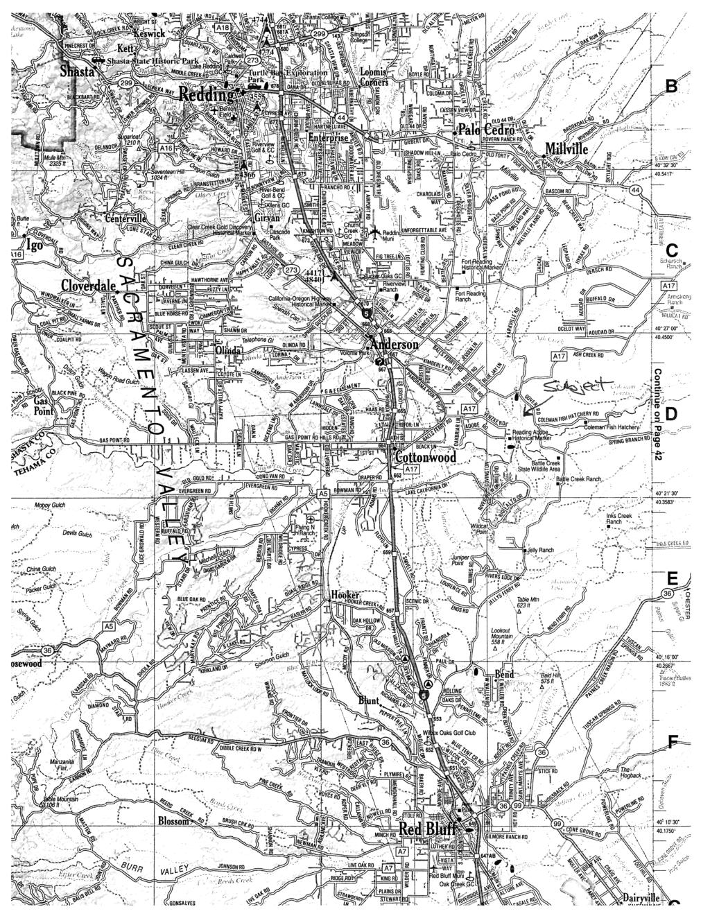
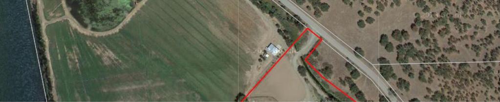
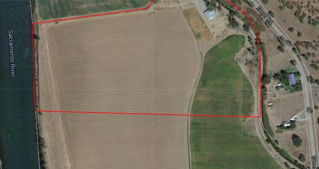
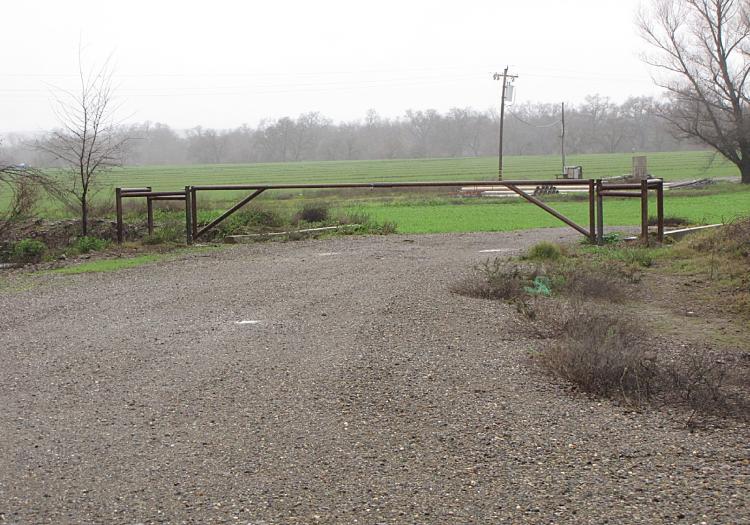
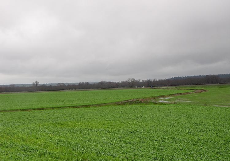
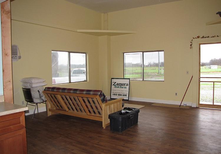
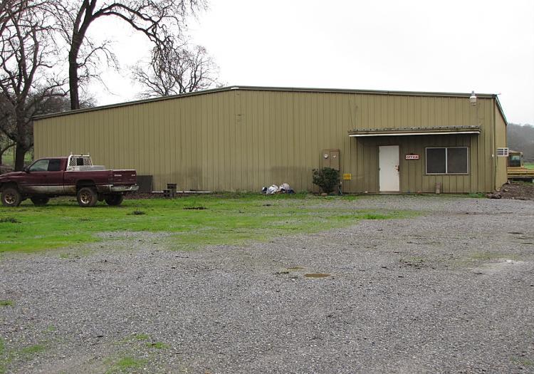
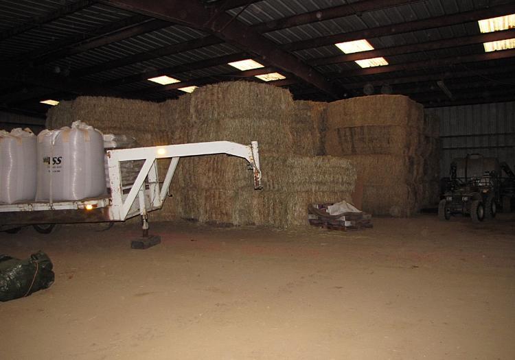
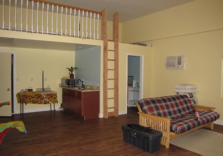
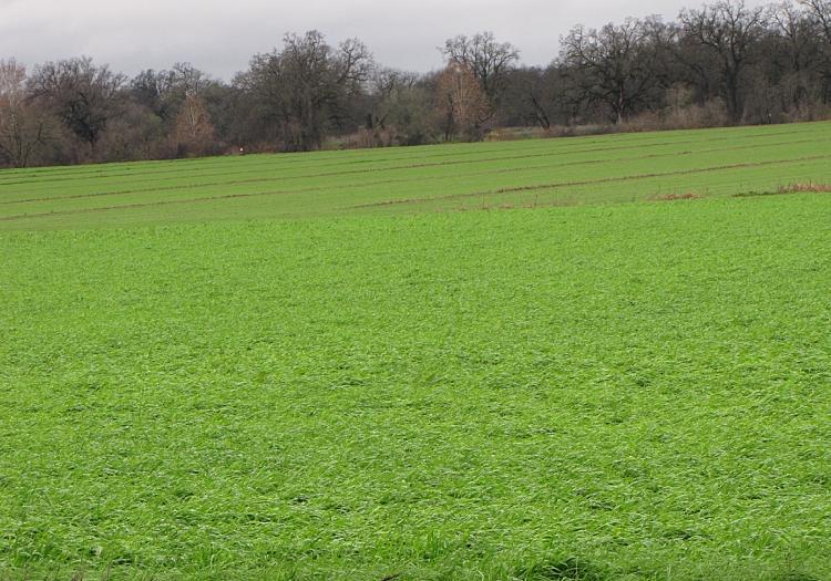
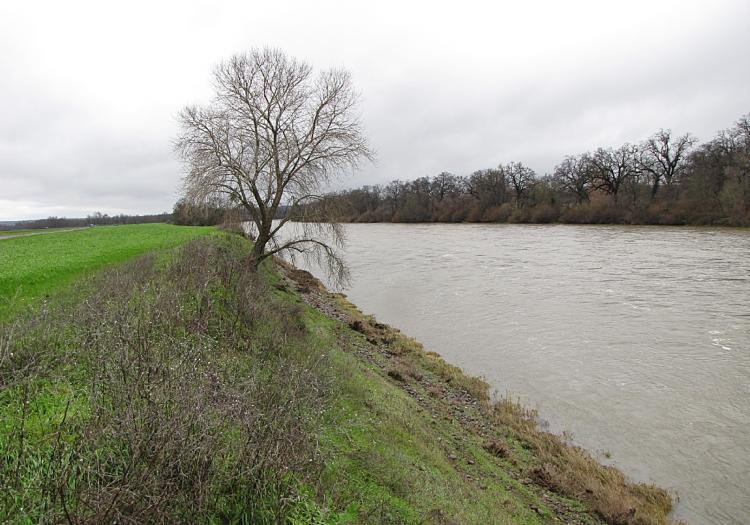
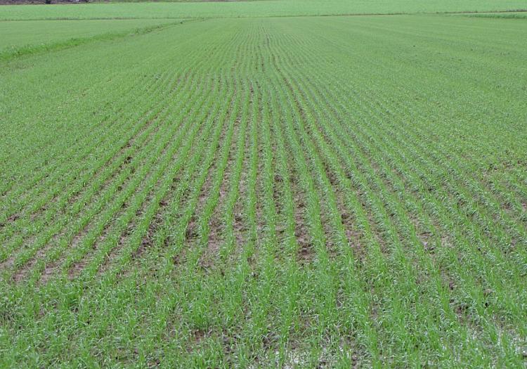
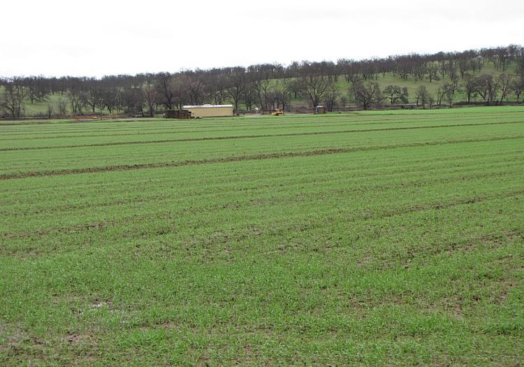
1 AG-LAND INVESTMENT BROKERS 275 Sale Lane / P. O. Box 896 Red Bluff, CA office / fax Sacramento River Farmland Anderson, California Property: 43 +/- acres of farmland with 665 +/- feet of Sacramento River frontage. Located downstream from the Balls Ferry Bridge on the east or left bank of the Sacramento River. Class 1 and 2 soils level for flood irrigation planted to winter grain. 25 miner inches of water rights from Battle Creek. Large metal shop with finished built-in apartment, domestic well plus septic. Location: As the bird flies, the farm is 4 5 miles east of Cottonwood, CA at 4324 Gover Road, Anderson, CA From Interstate 5, east onto Bowman Road, north onto Main Street, east onto 1 st Street, continue onto Balls Ferry Road, southeast onto Ash Creek Road, south onto Gover Road for about.7 of a mile. Property driveway is on the west side of Gover Road. Look for twin steel pole gates at driveway. Water: Irrigation water is diverted from Battle Creek and gravity flowed to the farm via the Gover Wilcox Ditch. Deeded water rights include 25 miner inches of water. Given the farmland is adjacent to the Sacramento River, riparian water rights may be available but they are not currently being used. At the farmstead is located a small groundwater well with submersible pump for domestic purposes. Irrigation: The farm land was recently laser leveled for flood irrigation. Current tenant owns the above ground aluminum pipe. Soils: Per Natural Resources Conservation Service, the Class I soils are RIA, Reiff loam and RgA, Reiff fine sandy loam. The Class II soils are RmA, Reiff loam, RgB, Reiff fine sandy loam and LfA, Los Robles gravelly loam. Except for the farmstead area, the topography is level to grade. Buildings: Shop, 75 x 80, 6,000 square feet. Metal framing and siding and skylights. Power, dirt floor, 14 door, concrete pad in southwest corner. Within a corner of the Shop is constructed a single room finished apartment, 19 x 24, 456 square feet. The apartment has laminate flooring, sleeping loft, wall A/C unit and 3/4 bathroom. Lease: Farmland and shop are leased to local farmer who has planted winter grain and uses the shop to store equipment and hay. Lease expires October 31, 2017, however, Seller reserved an option to terminate the lease earlier. The information contained herein is from sources deemed reliable, however, accuracy is not guaranteed. AG-LAND Investment Brokers assumes no liability as to errors, omissions or future operating and investment results. Buyer assumes responsibility to perform their own investigation and due diligence. This offering is subject to prior sale, price change or withdrawal from market without notice.
2 AG-LAND INVESTMENT BROKERS 275 Sale Lane / P. O. Box 896 Red Bluff, CA office / fax Zoning: Shasta County Parcel Number The property is zoned EA-BSM, Exclusive Agricultural District, Building Site Minimum. Current property taxes are $5,292 per year. Mineral Rights: Oil, gas, minerals and water rights owned by Seller are included. Depreciation: Improvements such as the shop, well, septic and irrigation system offer deprecation advantages to a prospective Buyer. Seller Financing: Seller will consider financing secured by note and first deed of trust with a minimum of 40% down payment. Balance of terms to be negotiated. Comments: Quality farm ground on an attractive and straight stretch of the Sacramento River. Options include continuing to grow annual crops, plant alfalfa or develop permanent tree crops. If you want to build a home, there s ample room at the farmstead area. This stretch of the Sacramento River is known for excellent salmon and trout fishing. Listing Price: $688,000. Sam Mudd, California Brokers License Number Cell, ; , sam.mudd@aglandbrokers.com website Bert Owens, California Brokers License Number Cell, ; , bert.owens@aglandbrokers.com, website The information contained herein is from sources deemed reliable, however, accuracy is not guaranteed. AG-LAND Investment Brokers assumes no liability as to errors, omissions or future operating and investment results. Buyer assumes responsibility to perform their own investigation and due diligence. This offering is subject to prior sale, price change or withdrawal from market without notice.
3
4

5 122 11' 32'' W Irrigated Capability Class Shasta County Area, California (4324 Gover Road NRCS Soils Map) ' 56'' W 40 24' 39'' N 40 24' 21'' N ' 39'' N 40 24' 21'' N ' 32'' W N Map Scale: 1:3,900 if printed on A landscape (11" x 8.5") sheet. Meters Feet Map projection: Web Mercator Corner coordinates: WGS84 Edge tics: UTM Zone 10N WGS ' 56'' W Natural Resources Conservation Service Web Soil Survey National Cooperative Soil Survey 12/17/2014 Page 1 of 4
6 Irrigated Capability Class Shasta County Area, California (4324 Gover Road NRCS Soils Map) MAP LEGEND MAP INFORMATION Area of Interest (AOI) Area of Interest (AOI) Soils Soil Rating Polygons Capability Class - I Capability Class - II Capability Class - III Capability Class - IV Capability Class - V Capability Class - VI Capability Class - VII Capability Class - VIII Not rated or not available Soil Rating Lines Capability Class - I Capability Class - II Capability Class - III Capability Class - IV Capability Class - V Capability Class - VI Capability Class - VII Capability Class - VIII Not rated or not available Soil Rating Points Capability Class - I Capability Class - II Capability Class - III Capability Class - IV Capability Class - V Capability Class - VI Capability Class - VII Capability Class - VIII Not rated or not available Water Features Streams and Canals Transportation Rails Interstate Highways US Routes Major Roads Local Roads Background Aerial Photography The soil surveys that comprise your AOI were mapped at 1:20,000. Warning: Soil Map may not be valid at this scale. Enlargement of maps beyond the scale of mapping can cause misunderstanding of the detail of mapping and accuracy of soil line placement. The maps do not show the small areas of contrasting soils that could have been shown at a more detailed scale. Please rely on the bar scale on each map sheet for map measurements. Source of Map: Natural Resources Conservation Service Web Soil Survey URL: Coordinate System: Web Mercator (EPSG:3857) Maps from the Web Soil Survey are based on the Web Mercator projection, which preserves direction and shape but distorts distance and area. A projection that preserves area, such as the Albers equal-area conic projection, should be used if more accurate calculations of distance or area are required. This product is generated from the USDA-NRCS certified data as of the version date(s) listed below. Soil Survey Area: Shasta County Area, California Survey Area Data: Version 9, Sep 17, 2014 Soil map units are labeled (as space allows) for map scales 1:50,000 or larger. Date(s) aerial images were photographed: Jun 12, 2010 Jun 30, 2010 The orthophoto or other base map on which the soil lines were compiled and digitized probably differs from the background imagery displayed on these maps. As a result, some minor shifting of map unit boundaries may be evident. Natural Resources Conservation Service Web Soil Survey National Cooperative Soil Survey 12/17/2014 Page 2 of 4
7 Irrigated Capability Class Shasta County Area, California 4324 Gover Road NRCS Soils Map Irrigated Capability Class IbD LfA Irrigated Capability Class Summary by Map Unit Shasta County Area, California (CA607) Map unit symbol Map unit name Rating Acres in AOI Percent of AOI Inks gravelly loam, 8 to 30 percent slopes Los Robles gravelly loam, 0 to 3 percent slopes RgA Reiff fine sandy loam, 0 to 3 percent slopes RgB Reiff fine sandy loam, 3 to 8 percent slopes RlA RmA Reiff loam, 0 to 3 percent slopes Reiff loam, seeped, 0 to 3 percent slopes % % % % % % Rw Riverwash % W Water % Totals for Area of Interest % Natural Resources Conservation Service Web Soil Survey National Cooperative Soil Survey 12/17/2014 Page 3 of 4
8 Irrigated Capability Class Shasta County Area, California 4324 Gover Road NRCS Soils Map Description Land capability classification shows, in a general way, the suitability of soils for most kinds of field crops. Crops that require special management are excluded. The soils are grouped according to their limitations for field crops, the risk of damage if they are used for crops, and the way they respond to management. The criteria used in grouping the soils do not include major and generally expensive landforming that would change slope, depth, or other characteristics of the soils, nor do they include possible but unlikely major reclamation projects. Capability classification is not a substitute for interpretations that show suitability and limitations of groups of soils for rangeland, for woodland, or for engineering purposes. In the capability system, soils are generally grouped at three levels-capability class, subclass, and unit. Only class and subclass are included in this data set. Capability classes, the broadest groups, are designated by the numbers 1 through 8. The numbers indicate progressively greater limitations and narrower choices for practical use. The classes are defined as follows: Class 1 soils have few limitations that restrict their use. Class 2 soils have moderate limitations that reduce the choice of plants or that require moderate conservation practices. Class 3 soils have severe limitations that reduce the choice of plants or that require special conservation practices, or both. Class 4 soils have very severe limitations that reduce the choice of plants or that require very careful management, or both. Class 5 soils are subject to little or no erosion but have other limitations, impractical to remove, that restrict their use mainly to pasture, rangeland, forestland, or wildlife habitat. Class 6 soils have severe limitations that make them generally unsuitable for cultivation and that restrict their use mainly to pasture, rangeland, forestland, or wildlife habitat. Class 7 soils have very severe limitations that make them unsuitable for cultivation and that restrict their use mainly to grazing, forestland, or wildlife habitat. Class 8 soils and miscellaneous areas have limitations that preclude commercial plant production and that restrict their use to recreational purposes, wildlife habitat, watershed, or esthetic purposes. Rating Options Aggregation Method: Dominant Condition Component Percent Cutoff: None Specified Tie-break Rule: Higher Natural Resources Conservation Service Web Soil Survey National Cooperative Soil Survey 12/17/2014 Page 4 of 4
9
10
11
12
13
Richfield Prunes, Pistachios & Walnuts
 AG-LAND Investment Brokers 275 Sale Lane Red Bluff, CA 96080 530-529-4400 Fax 530-527-5042 Richfield Prunes, Pistachios & Walnuts 210 +/- acres 3 Parcels Corning, CA - Tehama County jsubject AG-LAND
Farmland Classification Centre County, Pennsylvania (Student Farm Site) Web Soil Survey National Cooperative Soil Survey
 Web Soil Survey National Cooperative Soil Survey") 256300 256600 256900 257200 257500 257800 258100 77 51' 20'' W 77 53' 26'' W Farmland Classification Centre County, Pennsylvania 258400 258700 259000 40 49' 4'' N 4520600 4520900 4520900 4521200 4521200
256300 256600 256900 257200 257500 257800 258100 77 51' 20'' W 77 53' 26'' W Farmland Classification Centre County, Pennsylvania 258400 258700 259000 40 49' 4'' N 4520600 4520900 4520900 4521200 4521200
Yields of Non-Irrigated Crops (Component): Soybeans (Bu) Edgecombe County, North Carolina, and Halifax... (SOYBEANS)
: Soybeans (Bu) Edgecombe County, North Carolina, and Halifax... (SOYBEANS)") 77 37' 52'' W Yields of Non-Irrigated Crops (Component): Soybeans (Bu) Edgecombe County, North Carolina, and Halifax... () 77 36' 28'' W 263300 263600 263900 264200 264500 264800 265100 36 6' 59'' N 36
77 37' 52'' W Yields of Non-Irrigated Crops (Component): Soybeans (Bu) Edgecombe County, North Carolina, and Halifax... () 77 36' 28'' W 263300 263600 263900 264200 264500 264800 265100 36 6' 59'' N 36
 108 40' 29'' W Soil Map Mesa County Area, Colorado 108 36' 55'' W 39 10' 11'' N 39 6' 31'' N 4331700 4332500 4333300 4334100 4334900 4335700 4336500 4337300 4338100 701100 701900 702700 703500 704300 705100
Custom Soil Resource Report for Craighead County, Arkansas
 United States Department of Agriculture Natural Resources Conservation Service A product of the National Cooperative Soil Survey, a joint effort of the United States Department of Agriculture and other
Custom Soil Resource Report for Orange County, Virginia
 United States Department of Agriculture Natural Resources Conservation Service A product of the National Cooperative Soil Survey, a joint effort of the United States Department of Agriculture and other
FOR SALE ± ACRES VALENTINES, VIRGINIA Price: $150,000
 LATITUDE & LONGITUDE 36.566924, -77.764781 Features STRONG RECREATIONAL INVESTMENT opportunity located south of Triplet with access from VSR 600 (Triplet Rd.) to the north. TRACT HAS BEEN RECENTLY CUTOVER
Custom Soil Resource Report for Centre County, Pennsylvania
 United States Department of Agriculture Natural Resources Conservation Service A product of the National Cooperative Soil Survey, a joint effort of the United States Department of Agriculture and other
Custom Soil Resource Report for Pope County, Illinois
 United States Department of Agriculture Natural Resources Conservation Service A product of the National Cooperative Soil Survey, a joint effort of the United States Department of Agriculture and other
HCI ENGINEERING. March 27, City of Thornton, Development Engineering 9500 Civic Center Drive Thornton, CO 80229
 HCI ENGINEERING A division of HABERER CARPENTRY INC. March 27, 2014 Attn: Heath Klein, P.E. City of Thornton, Development Engineering 9500 Civic Center Drive Thornton, CO 80229 Re: Drainage Letter for
Farmland For Sale 3 Tracts /- acres Webster County, Iowa Section 31, T88N, R30W & Section 33, T88N, R29W
 Farmland For Sale 3 Tracts 316.02 +/- acres Webster County, Section 31, T88N, R30W & Section 33, T88N, R29W Contact Martin today! 309-242-7299 mthornton@hbtbank.com Martin G. Thornton, Broker 200 W. College
RaC. RaD GlG. GlF. RaD GlE. CeA. RaE. RcD. GoF. GoF SkC. SkD. CfA. AdA. GoF. GoF. GoF. RcD. GgD. GoF. RaE GlE. RaE DbF. GoF. DbE. RaC.
 526300 527400 528500 529600 530700 531800 532900 534000 535100 4240200 4241300 4242400 4243500 4244600 4245700 ADRIAN DR FAIRWAY DR STATE FARM DR DOLORES DR HUDIS ST SANTA ALICIA DR Cotati PAGE ST ALTA
Custom Soil Resource Report for Centre County, Pennsylvania
 United States Department of Agriculture Natural Resources Conservation Service A product of the National Cooperative Soil Survey, a joint effort of the United States Department of Agriculture and other
Custom Soil Resource Report Soil Map
 77 11' 22'' W Custom Soil Resource Report Soil Map 77 9' 43'' W 36 48' 13'' N 304700 304900 305100 305300 305500 305700 305900 306100 306300 306500 306700 306900 307100 36 48' 13'' N 36 47' 21'' N 4073800
Northeast Perkins County Pivots
 Northeast Perkins County Pivots 315.9± acres of center pivot irrigated farmland Southeast of Paxton, NE Email: Jordan@lashleyland.com Property Highlights List Price $1,550,000 Location Southeast of Paxton,
FOR SALE Kimberlina & Wallace Road Kern County, Ca
 Pistachio Orchard FOR SALE Kimberlina & Wallace Road Kern County, Ca The information contained herein may have been obtained from sources other than ASU Commercial. We have not verified such information
~ NRCS. Custom Soil Resource Report for Rifle Area, Colorado, Parts of Garfield and Mesa Counties. USDA United States ~ Department of Agriculture
 USA United States ~ epartment of Agriculture ~ NRCS Natural Resources Conservation Service A product of the National Cooperative Soil Survey, a joint effort of the United States epartment of Agriculture
Custom Soil Resource Report for Southampton County, Virginia
 United States Department of Agriculture Natural Resources Conservation Service A product of the National Cooperative Soil Survey, a joint effort of the United States Department of Agriculture and other
Deuel County Dryland
 Deuel County Dryland Two parcels of dryland farm ground near Lewellen, NE Property Highlights List Price $852,474 $786,877 Location 12-15 miles south of Lewellen, Ne or the same distance from Big Springs,
Everett Prune Farm Glenn County, California
 Everett Prune Farm Glenn County, California Proudly Offered By 707 Merchant Street, Suite 100, Vacaville, Ca 95688 (707) 455-4444 Office (707) 455-0455 Fax info@caoutdoorproperties.com www.californiaoutdoorproperties.com
~ NRCS. Custom Soil Resource Report for Rifle Area, Colorado, Parts of Garfield and Mesa Counties. Encana Upper Gate Communication Tower
 USA United States ~ epartment of Agriculture ~ NRCS Natural Resources Conservation Service A product of the National Cooperative Soil Survey, a joint effort of the United States epartment of Agriculture
Custom Soil Resource Report for Columbia County, New York
 United States Department of Agriculture Natural Resources Conservation Service A product of the National Cooperative Soil Survey, a joint effort of the United States Department of Agriculture and other
APPENDIX A SOIL RESOURCES REPORTS
 APPENDIX A SOIL RESOURCES REPORTS United States Department of Agriculture Natural Resources Conservation Service A product of the National Cooperative Soil Survey, a joint effort of the United States Department
FOR SALE. Arvin Edison Vineyard & Open Land Gross Acres Kern County, CA
 Arvin Edison Vineyard & Open Land FOR SALE Property Highlights Arvin Edison Water Storage District Class I and II Soils Neighboring properties planted to almonds, vineyards, and citrus The information
Custom Soil Resource Report for Clearfield County, Pennsylvania
 United States Department of Agriculture Natural Resources Conservation Service A product of the National Cooperative Soil Survey, a joint effort of the United States Department of Agriculture and other
Custom Soil Resource Report for Yamhill Area, Oregon
 United States Department of Agriculture Natural Resources Conservation Service A product of the National Cooperative Soil Survey, a joint effort of the United States Department of Agriculture and other
Custom Soil Resource Report for Centre County, Pennsylvania
 United States Department of Agriculture Natural Resources Conservation Service A product of the National Cooperative Soil Survey, a joint effort of the United States Department of Agriculture and other
LAND FOR SALE 314 ACRES M/L BERG, WORTH COUNTY, IOWA LISTING # DOUGLAS R. YEGGE C: O:
 LAND FOR SALE LISTING #13870 314 ACRES M/L BERG, WORTH COUNTY, IOWA DOUGLAS R. YEGGE C: 563-320-9900 O: 563-659-8185 Doug@PeoplesCompany.com ALAN MCNEIL C: 563-321-1125 O: 563-659-8185 Alan@PeoplesCompany.com
Custom Soil Resource Report for Polk County, Oregon
 United States Department of Agriculture Natural Resources Conservation Service A product of the National Cooperative Soil Survey, a joint effort of the United States Department of Agriculture and other
Land Sales Specialists Setting the trend for how Real Estate is sold in the Midwest.
 Land Sales Specialists Setting the trend for how Real Estate is sold in the Midwest. www.barnesrealty.com 18156 Hwy 59 Mound City, MO 64470 (660) 442-3177 1711 Oregon Hiawatha, KS 66434 (785) 742-4580
Custom Soil Resource Report for Centre County, Pennsylvania
 United States Department of Agriculture Natural Resources Conservation Service A product of the National Cooperative Soil Survey, a joint effort of the United States Department of Agriculture and other
Custom Soil Resource Report for Polk County, Oregon
 United States Department of Agriculture Natural Resources Conservation Service A product of the National Cooperative Soil Survey, a joint effort of the United States Department of Agriculture and other
Custom Soil Resource Report for Fond du Lac County, Wisconsin
 United States Department of Agriculture Natural Resources Conservation Service A product of the National Cooperative Soil Survey, a joint effort of the United States Department of Agriculture and other
Custom Soil Resource Report for Kent County, Maryland
 United States Department of Agriculture Natural Resources Conservation Service A product of the National Cooperative Soil Survey, a joint effort of the United States Department of Agriculture and other
Custom Soil Resource Report for Daviess County, Missouri
 United States Department of Agriculture Natural Resources Conservation Service A product of the National Cooperative Soil Survey, a joint effort of the United States Department of Agriculture and other
~ NRCS. Custom Soil Resource Report for Rifle Area, Colorado, Parts of Garfield and Mesa Counties. USDA United States ~ Department of Agriculture
 USA United States ~ epartment of Agriculture ~ NRCS Natural Resources Conservation Service A product of the National Cooperative Soil Survey, a joint effort of the United States epartment of Agriculture
NRCS Soils Report. Encana Oil & Gas (USA) Inc. C19 Injection Well. OA Project No
 Inc. C19 Injection Well. OA Project No") NRCS Soils Report Encana Oil & Gas (USA) Inc. C19 Injection Well OA Project No. 012-0178 826 21 ½ Road Grand Junction, CO 81505 TEL 970.263.7800 FAX 970.263.7456 United States Department of Agriculture
NRCS Soils Report Encana Oil & Gas (USA) Inc. C19 Injection Well OA Project No. 012-0178 826 21 ½ Road Grand Junction, CO 81505 TEL 970.263.7800 FAX 970.263.7456 United States Department of Agriculture
Custom Soil Resource Report for Hancock County Area, Maine
 United States Department of Agriculture Natural Resources Conservation Service A product of the National Cooperative Soil Survey, a joint effort of the United States Department of Agriculture and other
Soil Maps for Production Agriculture. Jarrod O. Miller, Extension Agronomist
 Soil Maps for Production Agriculture Jarrod O. Miller, Extension Agronomist Origination of Soil Mapping Originally mapped by Division of Soils Federal Bureau of Soils Soil Conservation Service (SCS) started
EXPERIMENT 6 PREPARATION OF LAND CAPABILITY CLASS MAP
 EXPERIMENT 6 PREPARATION OF LAND CAPABILITY CLASS MAP Structure 6.0 Objectives 6.1 Intnxluction 6.2 Experiment 6.21 Deciding Factors for Land Capability 6.2.2 Requirements 6.23 Procedure 6.3 Observations
Land Capability Classifications
 Land Capability Classifications Unit: Soil Science Problem Area: Basic Principles of Soil Science Student Learning Objectives. Instruction in this lesson should result in students achieving the following
365.8 Acres +/- Brown County, KS February 28, 2019 at 10:30 am Community Building, 511 West Front Street, Fairview, KS
 Farmland Auction February 28, 2019 at 10:30 am Community Building, 511 West Front Street, Fairview, KS This excellent Brown County farm is just North of Fairview, KS and it will be selling in 3 tracts
80 ACRES M/L CEDAR COUNTY, IA LISTING #465 DOUGLAS R. YEGGE ALAN MCNEIL. C: O:
 80 ACRES M/L CEDAR COUNTY, IA LISTING #465 DOUGLAS R. YEGGE C: 563-320-9900 O: 563-659-8185 total@totalrealtyco.com ALAN MCNEIL C: 563-321-1125 O: 563-659-8185 alan@totalrealtyco.com Kroemer, 80 Acres
280 ACRES - HOWELL COUNTY, MO
 PRICE: $434,700 ACRES: 280 COUNTY: HOWELL STATE: MISSOURI For more information contact: KYLE ORF, Land Agent 417.988.3333 KyleOrf@MidwestLandGroup.com MidwestLandGroup.com 100 280ACRES ACRES- -COUNTY,
ROSE CREEK RANCH WINNEMUCCA, NV HUMBOLDT AND PERSHING COUNTY
 ROSE CREEK RANCH WINNEMUCCA, NV HUMBOLDT AND PERSHING COUNTY Industrial & Residential Development Site I-80 frontage @ Hwy 40 interchange Heart of Nevada Gold Country 2,743 acres Enjoy hunting, farming
LAND FOR SALE 82 ACRES M/L CEDAR COUNTY, IOWA LISTING # DOUGLAS R. YEGGE C: O:
 LAND FOR SALE LISTING #13968 82 ACRES M/L CEDAR COUNTY, IOWA DOUGLAS R. YEGGE C: 563-320-9900 O: 563-659-8185 Doug@PeoplesCompany.com ALAN MCNEIL C: 563-321-1125 O: 563-659-8185 Alan@PeoplesCompany.com
Colusa County Almonds
 Morgan Houchin. 3430 Unicorn Road Bakersfield, CA 93308 mobile office efax 526.97 +/- Acres of Colusa County Almonds Cork McIsaac, Broker. Broker License No. 01216717 P.O. Box 1076 West Sacramento, CA
FOR SALE 280.5± ACRES SUSSEX COUNTY, VA Price: $430,000
 LATITUDE & LONGITUDE 37.5556, -79.2318 Winchester Front Royal 15 Leesburg 495 Washington 66 Chantilly Arlington Falls Church Fairfax Alexandria Springfield Manassas Warrenton 301 13 113 Dale City Waldorf
Custom Soil Resource Report for Gallia County, Ohio
 United States Department of Agriculture Natural Resources Conservation Service A product of the National Cooperative Soil Survey, a joint effort of the United States Department of Agriculture and other
NRCS Soils Report. Grand River Gathering LLC K28E Compressor Station. OA Project No
 NRCS Soils Report Grand River Gathering LLC K28E Compressor Station OA Project No. 012-032 82 21 ½ Road Grand Junction, CO 81505 TEL 90.23.800 FAX 90.23.45 United States Department of Agriculture A product
Custom Soil Resource Report for Ulster County, New York
 United States Department of Agriculture Natural Resources Conservation Service A product of the National Cooperative Soil Survey, a joint effort of the United States Department of Agriculture and other
173 ACRES - RILEY COUNTY, KS
 Buyers, Sellers & Land Connected PRICE: $690,000 ACRES: 173 COUNTY: RILEY STATE: KANSAS First Class Hunting with Outstanding Income Potential If you have ever dreamed of owning your very own piece of first
Bull Canyon Ranch 2750 BULL CANYON ROAD, SANTA MARIA, CALIFORNIA PRESENTED FOR SALE BY: Rincon corporation
 Bull Canyon Ranch 2750 BULL CANYON ROAD, SANTA MARIA, CALIFORNIA PRESENTED FOR SALE BY: Rincon corporation THE FULL SERVICE REAL ESTATE COMPANY FOR THE AGRICULTURAL COMMUNITY Bull canyon ranch, santa maria
Harding Real Estate Vacant Acres Thompson Rd., Woodstock, IL
 Harding Real Estate 325.31 Vacant Acres Thompson Rd., Woodstock, IL Randy Erwin, Broker Associate Natalie Torres, Broker Associate BHHS Starck Real Estate 1710 South Eastwood Dr. Woodstock, IL. 60098 Randy@RandyErwin.com
131 ACRES M/L VAN BUREN COUNTY, IOWA LISTING #458 JIM KEDLEY. C: O:
 131 ACRES M/L VAN BUREN COUNTY, IOWA LISTING #458 JIM KEDLEY C: 563-212-5401 O: 563-659-8185 Jimkedley@totalrealtyco.com CWC Holdings LLC, 131 Acres M/L, Van Buren County, IA TOTAL ACRES: 131 MOL PRICE:
Town of Brunswick, Maine - AGENDA - BRUNSWICK TOWN HALL 85 UNION STREET ROOM 206 WEDNESDAY, MARCH 1, 2017, 10:00 A.M.
 Town of Brunswick, Maine STAFF REVIEW COMMITTEE 85 Union Street Brunswick, ME 04011 - AGENDA - BRUNSWICK TOWN HALL 85 UNION STREET ROOM 206 WEDNESDAY, MARCH 1, 2017, 10:00 A.M. 1. Case #17-007 Fitzpatrick
Custom Soil Resource Report for Kane County, Illinois
 United States Department of Agriculture Natural Resources Conservation Service A product of the National Cooperative Soil Survey, a joint effort of the United States Department of Agriculture and other
Custom Soil Resource Report for Pope County, Illinois
 United States Department of Agriculture Natural Resources Conservation Service A product of the National Cooperative Soil Survey, a joint effort of the United States Department of Agriculture and other
SW CORNER ROUTE 38 AND HARLEY ROAD SW CORNER ROUTE 38 & HARLEY ROAD, KANE COUNTY, IL 60119
 REDUCED: Land For Sale SW CORNER ROUTE 38 AND HARLEY ROAD REDUCED: 124 AC ON IL ROUTE 38 OFFERING SUMMARY Sale Price: $1,643,000 Price / Acre: $13,250/AC PROPERTY OVERVIEW This 124 AC parcel has approximately
September 20, 2016 Soils Investigation for Agricultural Designation Windemere Place, Missoula County, Montana
 September 20, 201 Soils Investigation for Agricultural Designation Windemere Place, Missoula County, Montana The purpose of this report is to compare on-site soils of the proposed subdivision with the
Blue Fox Farm $1,795,000
 Offered Exclusively By: Blue Fox Farm 6105 Sulphur Well Road 117± acres Fayette County $1,795,000 Zach Davis Principal Broker +1.859.576.8195 www.kirkfarms.com zach@kirkfarms.com Hannah Davis Emig Agent
Demoss Farm & Home 118 Acres, M/L W. 209th Ave. Pattonsburg, Mo 64670
 118 Acres, M/L 39436 W. 209th Ave. Pattonsburg, Mo 64670 PRICE: $400,000.00 LAND USE: FSA shows approx. 118.32 farmland acres, ml, of which there were 36.47 acres of effective cropland with the remainder
Procedures IV. V. Rural Road Design Option
 i IV. Procedures A. All applicants required to prepare a Conservation Design Subdivision shall provide the Planning Board with a conceptual conventional subdivision design as well as a proposed layout
Conservation Plan. I. Property Information. II. Objectives. Natural Resource Objectives. Sustainability in Practice (SIP) Certified
 Certified") Conservation Plan Sustainability in Practice (SIP) Certified I. Property Information Vineyard Name and Establishment Date: Location: Map (attach showing blocks and acres): II. Objectives Natural Resource
Conservation Plan Sustainability in Practice (SIP) Certified I. Property Information Vineyard Name and Establishment Date: Location: Map (attach showing blocks and acres): II. Objectives Natural Resource
+/- 60 AC LAND FOR SALE HARLEY ROAD, ELBURN, IL 60119
 Land For Sale OFFERING SUMMARY Sale Price: $660,000 Price / Acre: $11,000 PROPERTY OVERVIEW +/- 60 acres available for purchase on the west side of Harley Road, South of Rt. 38. This site has Harley Road
BENNING ROAD & BRIDGES TRANSPORTATION IMPROVEMENTS NRCS SOIL RESOURCE REPORT DRAFT MAY 2016
 BENNING ROAD & BRIDGES TRANSPORTATION IMPROVEMENTS NRCS SOIL RESOURCE REPORT DRAFT MAY 2016 United States Department of Agriculture Natural Resources Conservation Service A product of the National Cooperative
Custom Soil Resource Report for State of Connecticut
 United States Department of Agriculture Natural Resources Conservation Service A product of the National Cooperative Soil Survey, a joint effort of the United States Department of Agriculture and other
McArthur Swamp Planning Unit. Fish, Plant, and Wildlife Habitat MCARTHUR SWAMP PLANNING UNIT
 McArthur Swamp Planning Unit Fish, Plant, and Wildlife Habitat Conduct surveys of the planning unit to identify biological resources and enable their protection. Most of the McArthur Swamp land acreage
LAND FOR SALE 30 ACRES M/L FLOYD COUNTY, IOWA LISTING # DOUGLAS R. YEGGE C: O:
 LAND FOR SALE LISTING #13886 30 ACRES M/L FLOYD COUNTY, IOWA DOUGLAS R. YEGGE C: 563-320-9900 O: 563-659-8185 Doug@PeoplesCompany.com ALAN MCNEIL C: 563-321-1125 O: 563-659-8185 Alan@PeoplesCompany.com
The Napa River Flood Protection Project
 The Napa River Flood Protection Project Creating Flood Protection and Restoring Geomorphic and Biological Processes Jeremy Sarrow, Napa County Flood Control & Water Conservation District June 2, 2014.
FARMLAND AUCTION. FSA INFORMATION: Farmland: acres Cropland: acres Tillable: acres
 FARMLAND AUCTION January 22, 2019 at 10:30 am Keep an eye on BarnesRealty.com for possible blizzard date of 1/24/2019 Fisher Community Center, 201 E. Iowa St. Hiawatha, KS 66434 Here is a very productive
Unit II Soil Management
 Unit II Soil Management Lesson 2: Using Soil Survey Manuals Soil survey manuals provide useful information for grassland management. Soil scientists evaluate the soil for chemical and physical properties,
EXHIBIT 5-1 VILLAGE OF WILD ROSE FUNCTIONAL CLASS AND AVERAGE DAILY TRAFFIC VOLUMES 2000 & 2003 DATA
 3400 3600 EXHIBIT 5-1 FUNCTIONAL CLASS AND AVERAGE DAILY TRAFFIC VOLUMES 2000 & 2003 DATA Rural Minor Arterial Rural Major Collector Rural Minor Collector Rural Local 2000 Traffic Count 2003 Traffic Count
An Analysis of Soil Features and. Their Suitability for Recreational Uses. Using the U.S.D.A. s Web Soil Survey
 Soils of Pheasant Branch Conservancy An Analysis of Soil Features and Their Suitability for Recreational Uses Using the U.S.D.A. s Web Soil Survey Dreux J. Watermolen, Sally J. Kefer, and Adam C. Mednick
Custom Soil Resource Report for Hinds County, Mississippi
 United States Department of Agriculture Natural Resources Conservation Service A product of the National Cooperative Soil Survey, a joint effort of the United States Department of Agriculture and other
2 Older farm homes on the land
 2 Older farm homes on the land LAND RANCHES EXCHANGES This ranch consists of 70 +/_ acres of level farmland. Prime 13700 POWERHOUSE RD POTTER VALLEY agricultural land at an attractive price. This property
ARTICLE IV: DEVELOPMENT STANDARDS 404 MASTER PLANNING
 IV 13 404 MASTER PLANNING Master Planning through the Site Analysis (Master Planning Site Analysis) or Planned Development (Master Planning Planned Development) is provided to encourage development which
Aerial Map. map center: 38 0' 55.53, ' S-4E Franklin County Illinois
 Aerial Map map center: 38 0' 55.53, -88 42' 58.78 0ft 594ft 1188ft 11/24/2016 Field borders provided by Farm Service Agency as of 5/21/2008. Soils data provided by University of at Champaign-Urbana. Topography
Analysis of Landscape Character for Visual Resource Management 1
 Analysis of Landscape Character for Visual Resource Management 1 Paul F. Anderson 2/ Abstract: Description, classification and delineation of visual landscape character are initial steps in developing
ADDENDUM TO BIOLOGICAL SCOPING SURVEY REPORT, BOTANICAL SURVEY AND WETLAND DELINEATION
 ADDENDUM TO BIOLOGICAL SCOPING SURVEY REPORT, BOTANICAL SURVEY AND WETLAND DELINEATION FOR AVALON INN (APN 069-241-27 & -04) 1201 & 1211 NORTH MAIN STREET FORT BRAGG, CA MENDOCINO COUNTY prepared for:
Land for Sale. Marion County, Georgia. $2,160,000 +/- 900 Acres $2,400 per Acre
 Land for Sale Marion County, Georgia 2 Contents Property Fact Sheet... 3 Regional Map... 4 Local Map... 5 Aerial Map... 6 Major Soil Types Map... 7 Soil Classification Map... 8 Soil Classification Table...
Custom Soil Resource Report for Choctaw County, Oklahoma, and McCurtain County, Oklahoma
 United States Department of Agriculture Natural Resources Conservation Service A product of the National Cooperative Soil Survey, a joint effort of the United States Department of Agriculture and other
FARMLAND FOR SALE ± Acres 5 Tracts
 Now is your chance to acquire productive farmland in Greene County, Illinois. Greene County, IL FARMLAND FOR SALE 756.08± Acres 5 Tracts Highly productive riverbottom farms Heavily improved with tiling
Please use the Assessment and Solution section of your Scantron to answer Questions 1 through 20.
 Please use the Assessment and Solution section of your Scantron to answer Questions 1 through 20. Scenario part 1: You own a small 40 acre farm which you have been growing forage crops on for several years.
Custom Soil Resource Report for Clark County, Missouri
 United States Department of Agriculture Natural Resources Conservation Service A product of the National Cooperative Soil Survey, a joint effort of the United States Department of Agriculture and other
TOWN OF SPRINGFIELD, NEW HAMPSHIRE
 TOWN OF SPRINGFIELD, NEW HAMPSHIRE NATURAL RESOURCES INVENTORY EXECUTIVE SUMMARY March 2008 Prepared by: Watershed to Wildlife, Inc. Natural Resource Consultants 42 Mill Street, Suite 3 Littleton, NH 03561
Custom Soil Resource Report for Van Buren County, Iowa
 United States Department of Agriculture Natural Resources Conservation Service A product of the National Cooperative Soil Survey, a joint effort of the United States Department of Agriculture and other
LAND AUCTION. Open House: Saturday, August 6th and Saturday, August 20th From 9:00 AM to 11:00 AM at 1220 C Avenue, Scranton, Iowa
 L-1005 LAND AUCTION 1,235+/- Acres, Carroll and Greene Counties, Iowa Friday, August 2, 201 10:00 AM at the Saint Joseph s Parish Center 501 North Locust Street Jefferson, Iowa Highlight Features: Over
Soil Survey of San Luis Obispo County, California Paso Robles Area
 United States Department of Agriculture Soil Conservation Service In cooperation with University of California Agricultural Experiment Station Soil Survey of San Luis Obispo County, California Paso Robles
Custom Soil Resource Report for Hinds County, Mississippi
 United States Department of Agriculture Natural Resources Conservation Service A product of the National Cooperative Soil Survey, a joint effort of the United States Department of Agriculture and other
SOILS IN URBAN / SUBURBAN LANDSCAPES. Lisa Krall Soil Scientist CT USDA NRCS Tolland, CT
 SOILS IN URBAN / SUBURBAN LANDSCAPES Lisa Krall Soil Scientist CT USDA NRCS Tolland, CT What is Urban Soil? Is This Soil? Is This Soil? active gravel pit pavement and buildings vegetated roadside areas
THE CHICKERING COMPANY
 THE CHICKERING COMPANY RANCHES, LAKES, RIVERS / BROKER P. O. BOX 238 NEVADA CITY, CA 95959 530-265-5774 Lic. No. 01100594 EMAIL: ranches@chickeringco.com WEBSITE: www.ranchbuyer.com FORESTHILL PRESERVE
BISCUIT RUN PARK MASTER PLAN
 BOARD OF SUPERVISORS November 14, 2018 BISCUIT RUN PARK MASTER PLAN COUNTY OF ALBEMARLE ANHOLD ASSOCIATES Contents Project Introduction Property Background County Park Planning Process Existing Site &
RED LODGE CREEK SHANE RIDGE RANCH
 RED LODGE CREEK SHANE RIDGE RANCH Roberts, Montana 59070 For additional details, contact: SCOTT R. GROSSKOPF Broker / Owner Member Landmark of Billings 1925 Grand Avenue, Ste. 144, Billings, MT 59102 Office:
STAFF REPORT FOR STANDARD COASTAL DEVELOPMENT PERMIT #CDP FEBRUARY 26, 2015 CPA - 1 PO BOX 238 APTOS, CA 94001
 STAFF REPORT FOR STANDARD COASTAL DEVELOPMENT PERMIT #CDP 2014-0030 FEBRUARY 26, 2015 CPA - 1 OWNER/APPLICANT: AGENT: REQUEST: HANS HEIM PO BOX 238 APTOS, CA 94001 JAMES HAY PO BOX 762 MENDOCINO, CA 95460
Pits 1 & 3 Questions. 7. Subsurface: Texture (5 pts) A. Coarse B. Moderately course C. Medium D. Fine E. Very Fine
 A. Coarse B. Moderately course C. Medium D. Fine E. Very Fine") Minnesota Soils Scorecard Questions for Pits 1-4 Scantron # 105481 Use your soils scorecard to fill out the answers on your scantron Bubble in the front side of the sheet for Pit 1 (# 1-45) and Pit 2 (#51-95)
Minnesota Soils Scorecard Questions for Pits 1-4 Scantron # 105481 Use your soils scorecard to fill out the answers on your scantron Bubble in the front side of the sheet for Pit 1 (# 1-45) and Pit 2 (#51-95)
80 ACRES M/L BOONE COUNTY, IOWA LISTING # Pilot Mound, Iowa. I Avenue. 130th Street. Co Hwy P th Street
 Co Hwy P70 I Avenue 80 ACRES M/L BOONE COUNTY, IOWA CAPTION Pilot Mound, 130th Street 130th Street LISTING #12320 New Listing Price! $800,000 DESCRIPTION: High Quality Farm in Strong Farming Area and potential
APPENDIX A SIMPLIFIED APPROACH TO STORMWATER MANAGEMENT FOR SMALL PROJECTS. In West Sadsbury Township, Chester County, Pennsylvania
 APPENDIX A SIMPLIFIED APPROACH TO STORMWATER MANAGEMENT FOR SMALL PROJECTS In West Sadsbury Township, Chester County, Pennsylvania TABLE OF CONTENTS I. Introduction 3 II. Importance of Stormwater Management
2016 Area 3 Envirothon Muskingum County Soils Test ANSWER KEY
 2016 Area 3 Envirothon Muskingum County Soils Test ANSWER KEY 1. The majority of the bedrock in Muskingum County is. a. sedimentary bedrock b. glacial bedrock c. igneous bedrock d. metamorphic bedrock
APPENDIX G LAND USE INVENTORY STUDY REPORT
 APPENDIX G LAND USE INVENTORY STUDY REPORT Study 10.0 - Land Use Inventory Land Use Inventory Loup River Hydroelectric Project FERC Project No. 1256 Study 10.0 Land Use Inventory August 26, 2010 2010 Loup