80 ACRES M/L BOONE COUNTY, IOWA LISTING # Pilot Mound, Iowa. I Avenue. 130th Street. Co Hwy P th Street
|
|
|
- Hilary McKinney
- 5 years ago
- Views:
Transcription


 and expiring in 2021.")


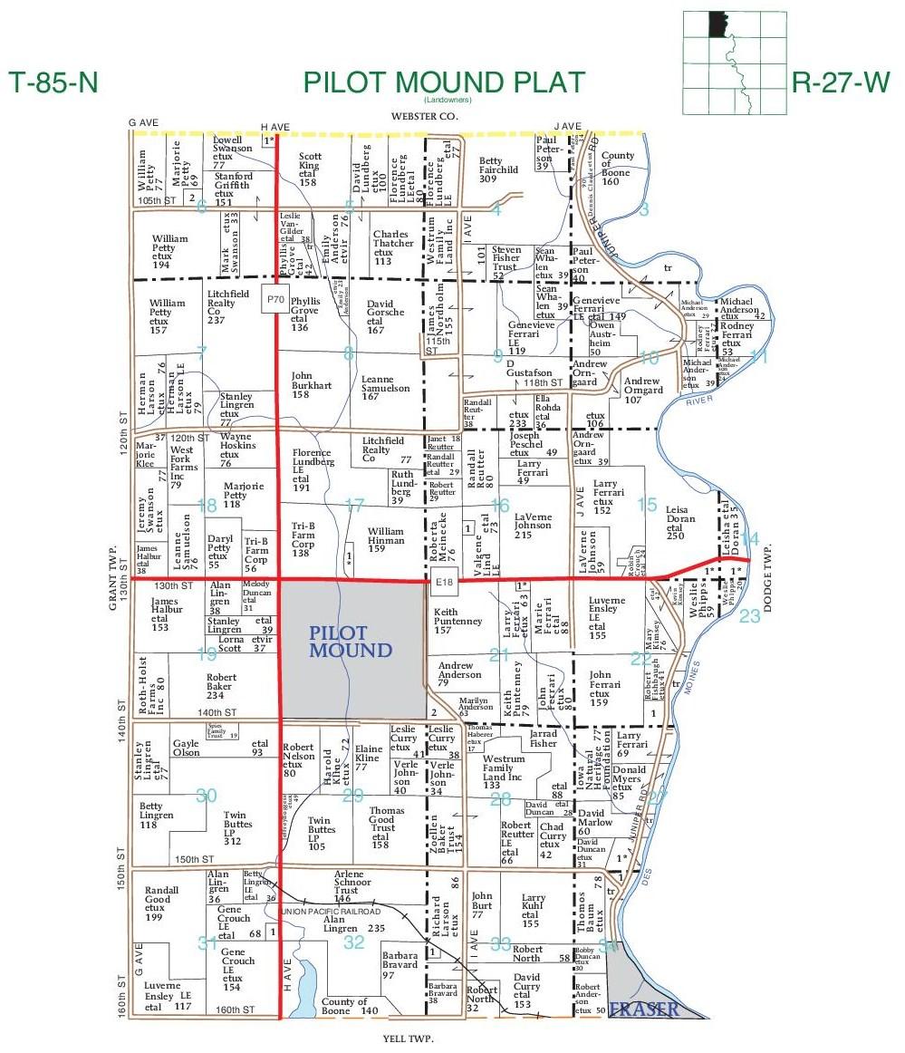
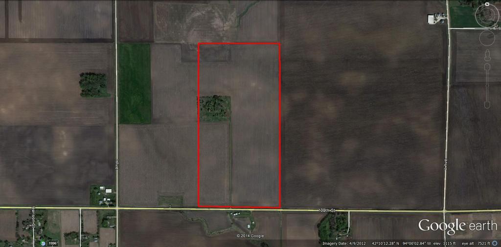
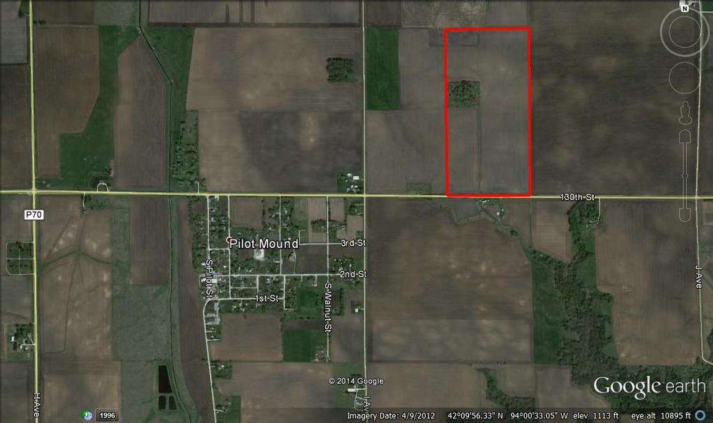
1 Co Hwy P70 I Avenue 80 ACRES M/L BOONE COUNTY, IOWA CAPTION Pilot Mound, 130th Street 130th Street LISTING #12320 New Listing Price! $800,000 DESCRIPTION: High Quality Farm in Strong Farming Area and potential to be nearly 100% tillable! 80 acres m/l consisting of NHEL FSA tillable acres (70.11 currently being farmed) with a tillable CSR of 85.1 (CSR2 of 88.7). 3 acres enrolled in CRP with an annual payment of $662 ($ per acre) and expiring in Approximately 6 acre building site could be converted back to farmland with ease and limited expense. Farm has been leased for 2015 farm year. High quality soil types include Nicollet loam, Canisteo silty clay loam, and Clarion loam. Farm is located on paved road just east of Pilot Mound, and in Section 16 of Pilot Mound Township. FARM PROGRAM INFORMATION: Contact Agent for details DIRECTIONS: From Pilot Mound: Travel 1/2 mile east of town on paved road 130th Street. Farm is located on the north side of the road and has 1/4 mile of road frontage. MATT ADAMS Cell: (515) Matt@PeoplesCompany.com

2 Aerial Map Boone County map center: 42 10' 12.07, 94 0' 7.75 scale: /24/2014
3 Soils Map-CSR(as of 1/21/12) State: County: Location: Township: Boone Pilot Mound Acres: Date: 10/24/2014 Soils data provided by USDA and NRCS. Viewing soils data as of 1/21/2012 Code Soil Description Acres Percent of field *CSR Legend Non-Irr Class CSR* 507 Canisteo silty clay loam, 0 to 2 percent slopes % IIw B Clarion loam, 2 to 5 percent slopes % IIe Nicollet loam, 1 to 3 percent slopes % I Harps loam, 0 to 2 percent slopes % IIw Blue Earth mucky silt loam, 0 to 1 percent slopes % IIIw Okoboji mucky silt loam, 0 to 1 percent slopes % IIIw Palms muck, 0 to 1 percent slopes % IIIw 51 Weighted Average 84.1 *The CSR ratings are dated 1/21/2012 and will be available to aid in the transition to CSR2.
4 Soils Map-CSR2 State: County: Location: Township: Boone Pilot Mound Acres: Date: 10/24/2014 Soils data provided by USDA and NRCS. Area Symbol: IA015, Soil Area Version: 19 Code Soil Description Acres Percent of field **CSR2 Legend Non-Irr Class CSR2** CSR 507 Canisteo silty clay loam, 0 to 2 percent slopes % IIw B Clarion loam, 2 to 6 percent slopes % IIe Nicollet loam, 1 to 3 percent slopes % I Harps loam, 0 to 2 percent slopes % IIw Blue Earth mucky silt loam, 0 to 1 percent slopes % IIIw Okoboji mucky silt loam, 0 to 1 percent slopes % IIIw Klossner muck, 0 to 1 percent slopes % IIIw Weighted Average Area Symbol: IA015, Soil Area Version: 19 **IA has updated the CSR values for each county to CSR2.

5 Soils Map-CSR(as of 1/21/12) State: County: Location: Township: Boone Pilot Mound Acres: Date: 10/24/2014 Soils data provided by USDA and NRCS. Viewing soils data as of 1/21/2012 Code Soil Description Acres Percent of field *CSR Legend Non-Irr Class CSR* 507 Canisteo silty clay loam, 0 to 2 percent slopes % IIw B Clarion loam, 2 to 5 percent slopes % IIe Nicollet loam, 1 to 3 percent slopes % I Okoboji mucky silt loam, 0 to 1 percent slopes % IIIw Harps loam, 0 to 2 percent slopes % IIw 64 Weighted Average 85.1 *The CSR ratings are dated 1/21/2012 and will be available to aid in the transition to CSR2.
6 Soils Map-CSR2 State: County: Location: Township: Boone Pilot Mound Acres: Date: 10/24/2014 Soils data provided by USDA and NRCS. Area Symbol: IA015, Soil Area Version: 19 Code Soil Description Acres Percent of field **CSR2 Legend Non-Irr Class CSR2** CSR 507 Canisteo silty clay loam, 0 to 2 percent slopes % IIw B Clarion loam, 2 to 6 percent slopes % IIe Nicollet loam, 1 to 3 percent slopes % I Okoboji mucky silt loam, 0 to 1 percent slopes % IIIw Harps loam, 0 to 2 percent slopes % IIw Weighted Average Area Symbol: IA015, Soil Area Version: 19 **IA has updated the CSR values for each county to CSR2.
7
8
9
Farmland For Sale 3 Tracts /- acres Webster County, Iowa Section 31, T88N, R30W & Section 33, T88N, R29W
 Farmland For Sale 3 Tracts 316.02 +/- acres Webster County, Section 31, T88N, R30W & Section 33, T88N, R29W Contact Martin today! 309-242-7299 mthornton@hbtbank.com Martin G. Thornton, Broker 200 W. College
LAND FOR SALE 314 ACRES M/L BERG, WORTH COUNTY, IOWA LISTING # DOUGLAS R. YEGGE C: O:
 LAND FOR SALE LISTING #13870 314 ACRES M/L BERG, WORTH COUNTY, IOWA DOUGLAS R. YEGGE C: 563-320-9900 O: 563-659-8185 Doug@PeoplesCompany.com ALAN MCNEIL C: 563-321-1125 O: 563-659-8185 Alan@PeoplesCompany.com
LAND FOR SALE 82 ACRES M/L CEDAR COUNTY, IOWA LISTING # DOUGLAS R. YEGGE C: O:
 LAND FOR SALE LISTING #13968 82 ACRES M/L CEDAR COUNTY, IOWA DOUGLAS R. YEGGE C: 563-320-9900 O: 563-659-8185 Doug@PeoplesCompany.com ALAN MCNEIL C: 563-321-1125 O: 563-659-8185 Alan@PeoplesCompany.com
LAND FOR SALE 30 ACRES M/L FLOYD COUNTY, IOWA LISTING # DOUGLAS R. YEGGE C: O:
 LAND FOR SALE LISTING #13886 30 ACRES M/L FLOYD COUNTY, IOWA DOUGLAS R. YEGGE C: 563-320-9900 O: 563-659-8185 Doug@PeoplesCompany.com ALAN MCNEIL C: 563-321-1125 O: 563-659-8185 Alan@PeoplesCompany.com
80 ACRES M/L CEDAR COUNTY, IA LISTING #465 DOUGLAS R. YEGGE ALAN MCNEIL. C: O:
 80 ACRES M/L CEDAR COUNTY, IA LISTING #465 DOUGLAS R. YEGGE C: 563-320-9900 O: 563-659-8185 total@totalrealtyco.com ALAN MCNEIL C: 563-321-1125 O: 563-659-8185 alan@totalrealtyco.com Kroemer, 80 Acres
131 ACRES M/L VAN BUREN COUNTY, IOWA LISTING #458 JIM KEDLEY. C: O:
 131 ACRES M/L VAN BUREN COUNTY, IOWA LISTING #458 JIM KEDLEY C: 563-212-5401 O: 563-659-8185 Jimkedley@totalrealtyco.com CWC Holdings LLC, 131 Acres M/L, Van Buren County, IA TOTAL ACRES: 131 MOL PRICE:
FARMLAND AUCTION. FSA INFORMATION: Farmland: acres Cropland: acres Tillable: acres
 FARMLAND AUCTION January 22, 2019 at 10:30 am Keep an eye on BarnesRealty.com for possible blizzard date of 1/24/2019 Fisher Community Center, 201 E. Iowa St. Hiawatha, KS 66434 Here is a very productive
365.8 Acres +/- Brown County, KS February 28, 2019 at 10:30 am Community Building, 511 West Front Street, Fairview, KS
 Farmland Auction February 28, 2019 at 10:30 am Community Building, 511 West Front Street, Fairview, KS This excellent Brown County farm is just North of Fairview, KS and it will be selling in 3 tracts
268 Acres m/l, Iowa County, IA. Offered in 2 Remaining Parcels. Parcel Ac. m/l Parcel 2-81 Ac. m/l Parcel 3-45 Ac. m/l - SOLD!
 LAND FOR SALE 268 Acres m/l, Iowa County, IA Offered in 2 Remaining Parcels Parcel 1-187 Ac. m/l Parcel 2-81 Ac. m/l Parcel 3-45 Ac. m/l - SOLD! Golden Grain Enterprises Good Iowa County Farms Located
Demoss Farm & Home 118 Acres, M/L W. 209th Ave. Pattonsburg, Mo 64670
 118 Acres, M/L 39436 W. 209th Ave. Pattonsburg, Mo 64670 PRICE: $400,000.00 LAND USE: FSA shows approx. 118.32 farmland acres, ml, of which there were 36.47 acres of effective cropland with the remainder
State: Kansas County: Sherman Location: S-037W Township: Union Acres: Date: 12/19/2011. Maps provided by:
 Soils Map State: Kansas County: Sherman Location: 007-009S-037W Township: Union Acres: 147.8 Date: 12/19/2011 Fsa borders provided by the Farm Service Agency as of May 23, 2008. Soils data provided by
LAND AUCTION. Open House: Saturday, August 6th and Saturday, August 20th From 9:00 AM to 11:00 AM at 1220 C Avenue, Scranton, Iowa
 L-1005 LAND AUCTION 1,235+/- Acres, Carroll and Greene Counties, Iowa Friday, August 2, 201 10:00 AM at the Saint Joseph s Parish Center 501 North Locust Street Jefferson, Iowa Highlight Features: Over
173 ACRES - RILEY COUNTY, KS
 Buyers, Sellers & Land Connected PRICE: $690,000 ACRES: 173 COUNTY: RILEY STATE: KANSAS First Class Hunting with Outstanding Income Potential If you have ever dreamed of owning your very own piece of first
Land Sales Specialists Setting the trend for how Real Estate is sold in the Midwest.
 Land Sales Specialists Setting the trend for how Real Estate is sold in the Midwest. www.barnesrealty.com 18156 Hwy 59 Mound City, MO 64470 (660) 442-3177 1711 Oregon Hiawatha, KS 66434 (785) 742-4580
Auction Location Eagles Club 316 S. 2 nd Street, Aberdeen, SD
 Auction Location Eagles Club 316 S. 2 nd Street, Aberdeen, SD Welcome We would like to invite and welcome you to our public auction! This is an excellent opportunity to add Brown County cropland to your
Deuel County Dryland
 Deuel County Dryland Two parcels of dryland farm ground near Lewellen, NE Property Highlights List Price $852,474 $786,877 Location 12-15 miles south of Lewellen, Ne or the same distance from Big Springs,
WALKER FEEDLOT Total taxable acres, part fenced. 4 homes & multiple nice/modern outbldgs hd feedyard with sprinklers a-shkd-0002
 ABILENE WALKER FEEDLOT 38.7 Total taxable acres, part fenced 4 homes & multiple nice/modern outbldgs 3500 hd feedyard with sprinklers a-shkd-0002 Center pivot irrigation from lagoons 999 hd feedlot A-SHDK-B020
We are pleased to present Leonard Thorston Revocable Trust ± Acres Charleston Township, Redwood County
 We are pleased to present Leonard Thorston Revocable Trust 158.72 ± Acres Charleston Township, Redwood County PARCEL 1 PARCEL 2 This property to be sold by Sealed Bid Auction Owner: Leonard Thorston Family
FOR SALE HILL FAMILY FARM WATKINS CORNER, AR. Phillips County, Arkansas: 2,300+/- Acre Irrigated Grain Farm NEW PRICE/YIELD UPDATES:
 SOLD FARMLAND ADVISORS FOR SALE HILL FAMILY FARM WATKINS CORNER, AR 2,300+/- Acres - Phillips County, Arkansas $10,950,000 Phillips County, Arkansas: 2,300+/- Acre Irrigated Grain Farm NEW PRICE/YIELD
Harding Real Estate Vacant Acres Thompson Rd., Woodstock, IL
 Harding Real Estate 325.31 Vacant Acres Thompson Rd., Woodstock, IL Randy Erwin, Broker Associate Natalie Torres, Broker Associate BHHS Starck Real Estate 1710 South Eastwood Dr. Woodstock, IL. 60098 Randy@RandyErwin.com
+/- 60 AC LAND FOR SALE HARLEY ROAD, ELBURN, IL 60119
 Land For Sale OFFERING SUMMARY Sale Price: $660,000 Price / Acre: $11,000 PROPERTY OVERVIEW +/- 60 acres available for purchase on the west side of Harley Road, South of Rt. 38. This site has Harley Road
FOR SALE NEW PRICE HILL FAMILY FARM WATKINS CORNER, AR. Phillips County, Arkansas: 2,300+/- Acre Irrigated Grain Farm NEW PRICE/YIELD UPDATES:
 NEW PRICE FARMLAND ADVISORS FOR SALE HILL FAMILY FARM WATKINS CORNER, AR 2,300+/- Acres - Phillips County, Arkansas $10,950,000 Phillips County, Arkansas: 2,300+/- Acre Irrigated Grain Farm NEW PRICE/YIELD
Pifer s. 1, /- Acres Clay County, MN. Written Bid. Land For Lease. WRITTEN BIDS DUE BEFORE: Friday, January 19, :00 p.m.
 1,666.53 +/- Acres Clay County, MN Written Bid Land For Lease WRITTEN BIDS DUE BEFORE: Friday, January 19, 2018 5:00 p.m. OWNER: Hogetvedt Family Rev Trust STOCK PHOTO General Information Land Lease Auction
Aerial Map. map center: 38 0' 55.53, ' S-4E Franklin County Illinois
 Aerial Map map center: 38 0' 55.53, -88 42' 58.78 0ft 594ft 1188ft 11/24/2016 Field borders provided by Farm Service Agency as of 5/21/2008. Soils data provided by University of at Champaign-Urbana. Topography
/- Acres Becker County, MN (see pgs 1-6) /- Acres Clay County, MN (see pgs 8-14) Pifer s Written Bid.
 /- Acres Clay County, MN (see pgs 8-14) Pifer s Written Bid.") 812.02 +/- Acres Becker County, MN (see pgs 1-6) 810.14 +/- Acres Clay County, MN (see pgs 8-14) Written Bid Land For Lease WRITTEN BIDS DUE BEFORE: Friday, December 8, 2017 5:00 p.m. OWNERS: Case Agricultural
812.02 +/- Acres Becker County, MN (see pgs 1-6) 810.14 +/- Acres Clay County, MN (see pgs 8-14) Written Bid Land For Lease WRITTEN BIDS DUE BEFORE: Friday, December 8, 2017 5:00 p.m. OWNERS: Case Agricultural
G T12 G J44 G J46 ST 2. Jerome. Martinstown. Numa. A Maryanna F. Wallin Estate Appanoose County, Iowa
 135th Ave 150th Ave 153rd Ave Elm St N 170th Ave 171st Ave 172nd St 175th Ave 51 0th St Highw ay 2 Highw ay 2 ST 2 Highw ay 2 G T12 135th Ave 522nd St 523rd St Jerome 140th Ave 524th St 1 2 G J44 3 160th
For Sale at $290,000.00
 We are pleased to present Stearns Property 77± Acres Forest Township, Rice County For Sale at $290,000.00 Listing Agent: Charles Wingert Office: 507-345-LAND (5263) Toll Free: 800-730-LAND (5263) Direct:
280 ACRES - HOWELL COUNTY, MO
 PRICE: $434,700 ACRES: 280 COUNTY: HOWELL STATE: MISSOURI For more information contact: KYLE ORF, Land Agent 417.988.3333 KyleOrf@MidwestLandGroup.com MidwestLandGroup.com 100 280ACRES ACRES- -COUNTY,
Tract 1. Tract 3. Tract 2. Tract 4. A Taylor Co., IA
 Newport Ave Sec. 7 Sec. 8 235th St Sec. 13 250 th St Sec. 18 Maryl and Ave Sec. 17 T68N R34W T68N R33W 250 th St Sec. 24 257t h St Sec. 19 2 Newp ort Way Sec. 20 Sec. 25 Latitude: 40.6872 N Longitude:
SW CORNER ROUTE 38 AND HARLEY ROAD SW CORNER ROUTE 38 & HARLEY ROAD, KANE COUNTY, IL 60119
 REDUCED: Land For Sale SW CORNER ROUTE 38 AND HARLEY ROAD REDUCED: 124 AC ON IL ROUTE 38 OFFERING SUMMARY Sale Price: $1,643,000 Price / Acre: $13,250/AC PROPERTY OVERVIEW This 124 AC parcel has approximately
LAND FOR SALE. Beautiful Farmstead. Pifer s. Price: $1,250, /- Acres Green County, WI
 Beautiful Farmstead LAND FOR SALE 176 +/- Acres Green County, WI Price: $1,250,000 Auction & Realty - Robert Scott Pifer, Broker (#56685-90) RE Entity License #937110-91, Auction Company License #429-53
Northeast Perkins County Pivots
 Northeast Perkins County Pivots 315.9± acres of center pivot irrigated farmland Southeast of Paxton, NE Email: Jordan@lashleyland.com Property Highlights List Price $1,550,000 Location Southeast of Paxton,
2014 Iowa FFA Soil Judging CDE Exam
 2014 Iowa FFA Soil Judging CDE Exam 1. Landscape position is one aspect of evaluating the surface features of a certain tract of land. Identifying the correct landscape position will indicate: a. If the
1. Tree & Stand Growth Group Presentations 2. Lab Tues Evaluating communities for wildlife habitat 3. Take Home Test next Tuesday
 NREM 301 Forest Ecology & Soils Day 16 October 9, 2008 1. Tree & Stand Growth Group Presentations 2. Lab Tues Evaluating communities for wildlife habitat 3. Take Home Test next Tuesday Create a Diagram
Soils and their Relationship with Agriculture
 Soils and their Relationship with Agriculture Presentation created by Thomas Gallagher Modified by Hank Bignell Capital Area Agriculture and Horticulture Program Cornell University Cooperative Extension
2016 Iowa FFA Soils Evaluation CDE Exam
 2016 Iowa FFA Soils Evaluation CDE Exam 1. Which of the following is true regarding soil horizons? a. A horizon is darker in color and has more organic matter b. B horizon is darker in color and has more
FARMLAND FOR SALE ± Acres 5 Tracts
 Now is your chance to acquire productive farmland in Greene County, Illinois. Greene County, IL FARMLAND FOR SALE 756.08± Acres 5 Tracts Highly productive riverbottom farms Heavily improved with tiling
Rural Soils Career Development Event
 Rural Soils Career Development Event Effective August 1, 2014 Important Note: Please thoroughly read the Introduction and General Rules Section at the beginning of this handbook for complete rules and
Land for Sale. Marion County, Georgia. $2,160,000 +/- 900 Acres $2,400 per Acre
 Land for Sale Marion County, Georgia 2 Contents Property Fact Sheet... 3 Regional Map... 4 Local Map... 5 Aerial Map... 6 Major Soil Types Map... 7 Soil Classification Map... 8 Soil Classification Table...
Farmland Classification Centre County, Pennsylvania (Student Farm Site) Web Soil Survey National Cooperative Soil Survey
 Web Soil Survey National Cooperative Soil Survey") 256300 256600 256900 257200 257500 257800 258100 77 51' 20'' W 77 53' 26'' W Farmland Classification Centre County, Pennsylvania 258400 258700 259000 40 49' 4'' N 4520600 4520900 4520900 4521200 4521200
256300 256600 256900 257200 257500 257800 258100 77 51' 20'' W 77 53' 26'' W Farmland Classification Centre County, Pennsylvania 258400 258700 259000 40 49' 4'' N 4520600 4520900 4520900 4521200 4521200
Land for Sale. Baker County, Georgia. $4,960,000 1,984 Acres $2,500 per Acre
 Land for Sale Baker County, Georgia $4,960,000 1,984 Acres $2,500 per Acre 2 Contents Property Fact Sheet... 3 Regional Map... 4 Local Map... 5 Aerial Map... 6 Major Soil Types Map... 7 Soil Classification
Sacramento River Farmland Anderson, California
 AG-LAND INVESTMENT BROKERS 275 Sale Lane / P. O. Box 896 Red Bluff, CA 96080 530.529.4400 office / 530.527.5042 fax Sacramento River Farmland Anderson, California Property: 43 +/- acres of farmland with
DANE COUNTY COMPREHENSIVE PLAN 5-YEAR UPDATE
 DANE COUNTY COMPREHENSIVE PLAN 5-YEAR UPDATE Dane County Towns Association December 17, 2013 Resource Protection Corridors DRAFT 12-10-2013 Resource Protection Corridors In all cases, when presented with
Darlington Pines 1,295. At a Glance: Property Features. Acreage: 622 +/- acres (Sub-dividable) Asking Price:
 Asking Price:") ONLY $ 1,95 PER ACRE Property Features Located in the fertile northern reaches of Holmes County, Florida, the 6-acre tract has been continuously owned by the Spann family for over 50 years, once serving
ONLY $ 1,95 PER ACRE Property Features Located in the fertile northern reaches of Holmes County, Florida, the 6-acre tract has been continuously owned by the Spann family for over 50 years, once serving
Soil Science Curriculum
 Soil Science Curriculum Content and lab derived from the USDA-NRCS Guides for Educators. Go to www.nrcs.usda.gov/soils for the Guides and additional pictures and diagrams. This lesson plan was adapted
SOIL SEPARATES. Soil Evaluator Day 2, Presentation 3-3/27/2018. Soil Texture, Page 1 TITLE 5 SOIL EVALUATOR CERTIFICATION TRAINING SOIL TEXTURE
 Soil Evaluator Day 2, Presentation 3-3/27/18 TITLE 5 SOIL EVALUATOR CERTIFICATION TRAINING SOIL TEXTURE Prepared for: Commonwealth of Massachusetts Department of Environmental Protection By L.A. Spokas,
Colusa County Almonds
 Morgan Houchin. 3430 Unicorn Road Bakersfield, CA 93308 mobile office efax 526.97 +/- Acres of Colusa County Almonds Cork McIsaac, Broker. Broker License No. 01216717 P.O. Box 1076 West Sacramento, CA
Soil Survey of Rice County, Minnesota
 United States Department of Agriculture Natural Resources Conservation Service In cooperation with the Minnesota Agricultural Experiment Station Soil Survey of Rice County, Minnesota NRCS Accessibility
Bull Canyon Ranch 2750 BULL CANYON ROAD, SANTA MARIA, CALIFORNIA PRESENTED FOR SALE BY: Rincon corporation
 Bull Canyon Ranch 2750 BULL CANYON ROAD, SANTA MARIA, CALIFORNIA PRESENTED FOR SALE BY: Rincon corporation THE FULL SERVICE REAL ESTATE COMPANY FOR THE AGRICULTURAL COMMUNITY Bull canyon ranch, santa maria
Quiz! Brief review of Tuesday s Lab Soil Bio- and Toposequences. Soil & Plant Water Please pick up next Tuesday s Lab Agricultural Ecosystems
 NREM 301 Day 10 Quiz! Brief review of Tuesday s Lab Soil Bio- and Toposequences Soil & Plant Water Please pick up next Tuesday s Lab Agricultural Ecosystems Coring is hard work! Finally got one! Sunshine
 108 40' 29'' W Soil Map Mesa County Area, Colorado 108 36' 55'' W 39 10' 11'' N 39 6' 31'' N 4331700 4332500 4333300 4334100 4334900 4335700 4336500 4337300 4338100 701100 701900 702700 703500 704300 705100
Custom Soil Resource Report for Craighead County, Arkansas
 United States Department of Agriculture Natural Resources Conservation Service A product of the National Cooperative Soil Survey, a joint effort of the United States Department of Agriculture and other
September 20, 2016 Soils Investigation for Agricultural Designation Windemere Place, Missoula County, Montana
 September 20, 201 Soils Investigation for Agricultural Designation Windemere Place, Missoula County, Montana The purpose of this report is to compare on-site soils of the proposed subdivision with the
John R Trainor Park Bidwell Park Bidwell-Sacramento River SP SITE Lake Oroville State Rec Area Alpine Park
 FIGURES 1. Site Vicinity Map 2. Site Map Showing Compost Pad Layout and Facility Features 3. Wells Within One Mile of Facility and Groundwater Basin Contour Map 4. Geologic Map 5. Soils Map 6. Zoning Map
DANE COUNTY COMPREHENSIVE PLAN 5-YEAR UPDATE. Madison Area Surveyors March 12, 2014 Resource Protection Corridors
 DANE COUNTY COMPREHENSIVE PLAN 5-YEAR UPDATE Madison Area Surveyors March 12, 2014 Resource Protection Corridors Resource Protection Corridors Part 1: Purposes and Concepts Resource Protection Corridors
CONNECTICUT ENVIROTHON 2012 SOILS QUESTIONS
 CONNECTICUT ENVIROTHON 2012 SOILS QUESTIONS Please select the best response to the following questions. There are 25 4 point questions. Many have more than one part. Good luck! Section 1: Judging the soil
Farmland Classification
 name 1A Fluvaquents-Udifluvents complex, 0 to 3 Not prime farmland 100, frequently flooded 2A Geneseo silty clay loam, 0 to 3 All areas are prime farmland 100 3A Hemlock silty clay loam, 0 to 3 All areas
Area 3 Envirothon Soils Questions Key
 Area 3 Envirothon Soils Questions Key 1. Soil aeration is the exchange of air in soil with air from the atmosphere. When a soil is well aerated, the air within the soil is very similar to the atmosphere
NYC Envirothon 2017 Soil Science Review. Richard K Shaw USDA-NRCS
 NYC Envirothon 2017 Soil Science Review Richard K Shaw USDA-NRCS Introduction Who Are We? U.S. Department of Agriculture (1862) Natural Resources Conservation Service (1935) What Do We Do? Provide leadership
Electrical Conductivity (EC)
") name 1A Fluvaquents-Udifluvents complex, 0 to 3 0.0 45, frequently flooded 2A Geneseo silty clay loam, 0 to 3 0.0 90 3A Hemlock silty clay loam, 0 to 3 0.0 90 4A Naples Creek silty clay loam, 0 to 3 0.0
name 1A Fluvaquents-Udifluvents complex, 0 to 3 0.0 45, frequently flooded 2A Geneseo silty clay loam, 0 to 3 0.0 90 3A Hemlock silty clay loam, 0 to 3 0.0 90 4A Naples Creek silty clay loam, 0 to 3 0.0
Orchard Irrigation. Topic. Topic. Suppliers. Drip. Emitters Types 1/28/2013. Design & Operation of Irrigation Systems for Orchards
 Orchard Irrigation Joseph M. Hannan Commercial Horticulture Field Specialist Serving Central and Western IA Iowa State University Extension 28059 Fairground Rd. Adel IA jmhannan@iastate.edu 515.993.4281
Custom Soil Resource Report Soil Map
 77 11' 22'' W Custom Soil Resource Report Soil Map 77 9' 43'' W 36 48' 13'' N 304700 304900 305100 305300 305500 305700 305900 306100 306300 306500 306700 306900 307100 36 48' 13'' N 36 47' 21'' N 4073800
FOR SALE ± ACRES VALENTINES, VIRGINIA Price: $150,000
 LATITUDE & LONGITUDE 36.566924, -77.764781 Features STRONG RECREATIONAL INVESTMENT opportunity located south of Triplet with access from VSR 600 (Triplet Rd.) to the north. TRACT HAS BEEN RECENTLY CUTOVER
Percent Clay. Ontario County, New York Survey Area Version and Date: 13-09/24/2016
 name 1A Fluvaquents-Udifluvents complex, 0 to 3 5.3 45, frequently flooded 2A Geneseo silty clay loam, 0 to 3 19.7 90 3A Hemlock silty clay loam, 0 to 3 25.3 90 4A Naples Creek silty clay loam, 0 to 3
We are pleased to present Delwyn Spronk Farm ± Acres Elmer Township, Pipestone County
 We are pleased to present Delwyn Spronk Farm 79.09 ± Acres Elmer Township, Pipestone County SUBJECT PROPERTY This property to be sold by Sealed Bid Auction Owner: Delwyn & Julie Spronk Owner s Attorney:
EXHIBIT 6-1 TOWN OF AURORA COMMUNITY FACILITIES. Aurora Municipal Building. Cell Tower (U.S. Cellular) Cell Tower (AAT Communication)
 Cell Tower (AAT Communication)") 3ST AVE 3ND AVE EXHIBIT 6- COMMUNITY FACILITIES Aurora Municipal Building Cell Tower (U.S. Cellular) Cell Tower (AAT Communication) 8 9 0 Cell Tower (Alltel Corporation) Waste Collection Site Aurora Center
3ST AVE 3ND AVE EXHIBIT 6- COMMUNITY FACILITIES Aurora Municipal Building Cell Tower (U.S. Cellular) Cell Tower (AAT Communication) 8 9 0 Cell Tower (Alltel Corporation) Waste Collection Site Aurora Center
Depth to a Selected Soil Restrictive Layer
 1A 2A 3A 4A 5A 12D 13F 14D 15A 15B 16A 16B 16C 18A 19A 20A 24A 24B 24C 24D 25A 25B 25C 25D 25E 26B 27B 31A 31B 31C 31D 32A 32B 33A 33B 33C 33D 33E 34A 35A 35B Fluvaquents-Udifluvents complex, 0 to 3, frequently
Irrigation Toolbox Chapter 1
 USDA Natural Resources Conservation Service Irrigation Toolbox Chapter 1 Lesson Plan No. 1 Soil-Water Relationship OBJECTIVE: To provide participants with some basic information about the physical properties
Depth to Any Soil Restrictive Layer
 1A 2A 3A 4A name Fluvaquents-Udifluvents complex, 0 to 3, frequently flooded Geneseo silty clay loam, 0 to 3 Hemlock silty clay loam, 0 to 3 Naples Creek silty clay loam, 0 to 3 5A Wayland soils complex,
Horner-McLaughlin Woods: Soil Types
 Horner-McLaughlin Woods: Soil Types Not present at HMW Adrian Muck Conover Loam 0-4% Slopes Houghton Muck Miami Loam 2-6% Slopes Miami Loam 6-12% Slopes Miami Loam 12-18% Slopes t 0 0.125 0.25 Miles Mary
Range Production (Unfavorable Year)
") name 1A Fluvaquents-Udifluvents complex, 0 to 3 45, frequently flooded 2A Geneseo silty clay loam, 0 to 3 3A Hemlock silty clay loam, 0 to 3 4A Naples Creek silty clay loam, 0 to 3 5A Wayland soils complex,
name 1A Fluvaquents-Udifluvents complex, 0 to 3 45, frequently flooded 2A Geneseo silty clay loam, 0 to 3 3A Hemlock silty clay loam, 0 to 3 4A Naples Creek silty clay loam, 0 to 3 5A Wayland soils complex,
Team number Page 1 of Canon Envirothon Soils Station Test. Soils and Climate Change
 Team number Page 1 of 9 2006 Canon Envirothon Soils Station Test Soils and Climate Change There are many kinds of soil on the surface of the earth. The kind of soil that is present at a given location
Saturated Hydraulic Conductivity (Ksat), Standard Classes
, Standard Classes") name 1A Fluvaquents-Udifluvents complex, 0 to 3 70.7261 45, frequently flooded 2A Geneseo silty clay loam, 0 to 3 3.1399 90 3A Hemlock silty clay loam, 0 to 3 4.1265 90 4A Naples Creek silty clay loam,
name 1A Fluvaquents-Udifluvents complex, 0 to 3 70.7261 45, frequently flooded 2A Geneseo silty clay loam, 0 to 3 3.1399 90 3A Hemlock silty clay loam, 0 to 3 4.1265 90 4A Naples Creek silty clay loam,
2012 FINAL SOILS AREA 2 Envirothon Questions Answer KEY
 2012 FINAL SOILS AREA 2 Envirothon Questions Answer KEY Questions 1-6 to be answered at the soil pit: 1. Soil scientists categorize soils by drainage classes. What is the drainage class of the soil at
Water Balance Study: Manoa Valley Sept 2 to Nov 4, Tineill Dudoit - Shellie Habel - Madi Miyamura Shintaro Russell - Kenui Topp
 Water Balance Study: Manoa Valley Sept 2 to Nov 4, 2016 Tineill Dudoit - Shellie Habel - Madi Miyamura Shintaro Russell - Kenui Topp Mānoa Valley Site Area: Mānoa Valley, (11,187,443 m^2 ) faces along
Land Capability Classifications
 Land Capability Classifications Unit: Soil Science Problem Area: Basic Principles of Soil Science Student Learning Objectives. Instruction in this lesson should result in students achieving the following
Information for File # RMM
 Information for File #2015-00067-RMM Applicant: New Ulm Public Schools Corps Contact: Ryan Malterud Address: 180 Fifth Street East, Suite 700, St. Paul, Minnesota 55101-1678 E-Mail: ryan.m.malterud@usace.army.mil
UV 59. tu 34 University of Illinois at Urbana-Champaign
 Ferry Road Project Location North Aurora Road Aurora Avenue New York Street tu 3 etland Science Program Figure 1 Project Location Map DuPage County Seq. No: 1150 0 500 0 2,000 PFO1A PUBHX PFO1A PFO1A FO1C
2016 Area 3 Envirothon Muskingum County Soils Test ANSWER KEY
 2016 Area 3 Envirothon Muskingum County Soils Test ANSWER KEY 1. The majority of the bedrock in Muskingum County is. a. sedimentary bedrock b. glacial bedrock c. igneous bedrock d. metamorphic bedrock
POST CONSTRUCTION STORMWATER MANAGEMENT FOR "WHITE OAK SEWER INTERCEPTOR"
 POST CONSTRUCTION STORMWATER MANAGEMENT PLAN FOR "WHITE OAK SEWER INTERCEPTOR" Located in Newberry Township, York County March 21, 2008 Prepared by: Mellott Engineering, Inc. 7500 Devonshire Heights Road
Tools to facilitate the use of Soil Maps in Emilia-Romagna region (Italy) Paola Tarocco
 Paola Tarocco") Tools to facilitate the use of Soil Maps in Emilia-Romagna region (Italy) Paola Tarocco Soil maps Vs Thematic maps Soil maps are not easy to manage. Legends are usually based on soil classifications (e.g.
Tools to facilitate the use of Soil Maps in Emilia-Romagna region (Italy) Paola Tarocco Soil maps Vs Thematic maps Soil maps are not easy to manage. Legends are usually based on soil classifications (e.g.
FOR SALE. Arvin Edison Vineyard & Open Land Gross Acres Kern County, CA
 Arvin Edison Vineyard & Open Land FOR SALE Property Highlights Arvin Edison Water Storage District Class I and II Soils Neighboring properties planted to almonds, vineyards, and citrus The information
Submittal Document II.I. USDA NRCS Soil Resources Report
 Submittal Document II.I. USDA NRCS Soil Resources Report United States Department of Agriculture Natural Resources Conservation Service A product of the National Cooperative Soil Survey, a joint effort
RaC. RaD GlG. GlF. RaD GlE. CeA. RaE. RcD. GoF. GoF SkC. SkD. CfA. AdA. GoF. GoF. GoF. RcD. GgD. GoF. RaE GlE. RaE DbF. GoF. DbE. RaC.
 526300 527400 528500 529600 530700 531800 532900 534000 535100 4240200 4241300 4242400 4243500 4244600 4245700 ADRIAN DR FAIRWAY DR STATE FARM DR DOLORES DR HUDIS ST SANTA ALICIA DR Cotati PAGE ST ALTA
HOW TO USE THE NITRATE QUICK TEST
 HOW TO USE THE NITRATE QUICK TEST Standard Operating Procedures prepared for the Grower-Shipper Association of Central California by Stefanie Kortman with the assistance of Marc Los Huertos Spanish Translation
Managing sprinkler irrigation systems
 Section L Managing sprinkler irrigation systems The circular irrigation pattern of the center pivot results is illustrated in Figure L-1. The system is a typical seven to eight span pivot with span widths
Unit II Soil Management
 Unit II Soil Management Lesson 2: Using Soil Survey Manuals Soil survey manuals provide useful information for grassland management. Soil scientists evaluate the soil for chemical and physical properties,
HCI ENGINEERING. March 27, City of Thornton, Development Engineering 9500 Civic Center Drive Thornton, CO 80229
 HCI ENGINEERING A division of HABERER CARPENTRY INC. March 27, 2014 Attn: Heath Klein, P.E. City of Thornton, Development Engineering 9500 Civic Center Drive Thornton, CO 80229 Re: Drainage Letter for
Any County, New York. Custom Soil Resource Report for. Homer Vegetable Research Farm. United States Department of Agriculture
 United States Department of Agriculture Natural Resources Conservation Service A product of the National Cooperative Soil Survey, a joint effort of the United States Department of Agriculture and other
Soil characteristics that influence nitrogen and water management
 Section C Soil characteristics that influence nitrogen and water management Soil characteristics vary across the landscape Soils vary from one field to another, and often within the same field. Soil differences
Iowa FFA Soil Career Development Event 2008
 Iowa FFA Soil Career Development Event 2008 1. In Iowa, corn suitability ratings for soil mapping units specifies a. natural weather conditions b. surface and subsurface drainage installed where needed
Custom Soil Resource Report for Kane County, Illinois
 United States Department of Agriculture Natural Resources Conservation Service A product of the National Cooperative Soil Survey, a joint effort of the United States Department of Agriculture and other
S9. Thin Dark Surface
 Dominant Field Indicators of Hydric Soils in Florida S9. Thin Dark Surface For use in LRRs R, S, U, and T; for testing in LRRs K and L. A layer 5 cm (2 inches) or more thick within the upper 15 cm (6 inches)
Information for File # ARC
 Information for File # 2017-03115-ARC Applicant Consultant Corps Contact Bob Manzoline St. Louis and Lake Counties Regional Rail Authority Natalie White Short Elliot Hendrickson (SEH) Inc. Andrew R Chambers
BLOOMSBURY BOROUGH. Regional Master Plan Overlay Zone Designation. 1 inch = 0.28 miles. Zone. Sub-Zone FRANKLIN TOWNSHIP GREENWICH TOWNSHIP
 Regional Master Plan Overlay Zone Designation Zone Protection Lakes Greater Than 10 acres Conservation Existing Community Sub-Zone Existing Community Environmentally Constrained Conservation Environmentally
IOWA FFA STATE SOILS CDE SATURDAY, OCTOBER 13, 2007 AMES, IOWA
 IOWA FFA STATE SOILS CDE SATURDAY, OCTOBER 13, 2007 AMES, IOWA 1. Moderately sloping has what percent slope: a. 9-14% b. 2-5% c. 5-9% d. over 14% 2. Which of the following horizons is the loose underlying
Sam Furr and McCord Road Huntersville, North Carolina
 108± Acres of Sam Furr and McCord Road Huntersville, North Carolina NorthCross Shopping Center Land for Sale 108 Acres located in northeast Huntersville wth extensive frontage along both Sam Furr Road
Drainage Report. For: Owner/Developer:
 Drainage Report For: My Place Hotel Lot 6, Charles Ritz Subdivision Overland Park, KS Owner/Developer: Overland Park Holdings, LLC Matt Eller 104 Campus Drive, Suite 202 Huxley, IA 50124 Civil Engineer:
Custom Soil Resource Report for Tompkins County, New York
 United States Department of Agriculture Natural Resources Conservation Service A product of the National Cooperative Soil Survey, a joint effort of the United States Department of Agriculture and other
Percent Silt. Ontario County, New York Survey Area Version and Date: 13-09/24/2016
 name 1A Fluvaquents-Udifluvents complex, 0 to 3 10.9 45, frequently flooded 2A Geneseo silty clay loam, 0 to 3 44.1 90 3A Hemlock silty clay loam, 0 to 3 45.4 90 4A Naples Creek silty clay loam, 0 to 3