We are pleased to present Leonard Thorston Revocable Trust ± Acres Charleston Township, Redwood County
|
|
|
- George Kennedy
- 5 years ago
- Views:
Transcription
1 We are pleased to present Leonard Thorston Revocable Trust ± Acres Charleston Township, Redwood County PARCEL 1 PARCEL 2 This property to be sold by Sealed Bid Auction Owner: Leonard Thorston Family Owner s Attorney: Jeannette Pidde; Muske, Suhrhoff & Pidde, LTD., Springfield, MN Date & Time: Thursday, September 27, 11 a.m. Location: Springfield Community Center, 33 South Cass Avenue Springfield MN Note: See Sealed Bid Information page in the back of this brochure for more details. Only registered bidders may attend. Must be registered prior to auction date. Listing Agent: Chuck Wingert, ALC Office: LAND (5263) Toll Free: LAND (5263) Direct: Auctioneer # Charles@WingertRealty.com PARCEL 3 = PARCELS 1+2


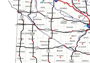
2 State Highway Map Minneapolis SUBJECT PROPERTY Mankato

3 Redwood County Minnesota SUBJECT PROPERTY

4 Charleston Township Redwood County PARCEL 1 PARCEL 2
5 FSA Aerial View - Parcel 1 Orange lines represent FSA breakdown, not property lines. Parcel 1 = all land north of Judicial Ditch # 35 Parcel 2 = all land south of Judicial Ditch # 35 PARCEL 1 PARCEL 1 Judicial Ditch # 35
6 Property Information - Parcel 1 DESCRIPTION: ± Acres. NE¼ lying north of the centerline of Judicial Ditch # 35. Section 1, T109N-R36W (Charleston Township, Redwood County, MN) TAX PID #: BUILDINGS: (78.72 ± ac-n½ of NE¼), (80 ± ac-s½ of NE¼) None REAL ESTATE TAXES: 2018 Ag Non- Hmstd taxes = $4, (78.72 ± ac) = $2, Special Assessment = $ JD 35 & 36 (included above) (80 ± ac) = $2, Special Assessment = $ JD 35 & 36 (included above) *If Parcels 1 & 2 are sold separately, the County Assessor will recalculate taxes attributed to each parcel for 2019 taxes. FSA INFORMATION: Total acres = ± acres *FSA Tillable acres = ± acres *Corn base acres = ± acres Corn PLC Yield =162 ± bushels *Soybean base acres = ± acres Soybean PLC Yield = 39 ± bushels Farm Program Info - Enrolled into Agricultural Risk Coverage (ARC) County *If Parcels 1 & 2 are sold seperately, FSA will recalculate base acres after sale. SOIL DESCRIPTION: Canisteo, Amiret, Swanlake, Seaforth, Glencoe, Okoboji, Webster, Normania. See Soils Map. CPI: Crop Productivity Index = 92.5 BUFFER STRIPS: TOPOGRAPHY: DRAINAGE: Non compliant. Per Minnesota Buffer Law regulations, one rod buffer strips will need to be installed on the open ditch banks by November 1, If buffer strips are not in compliance as of that date, the landowner will be notified that the buffers will need to be installed within 11 months. Level to rolling Outlet: Judicial Ditch # 35. Tile: Random laterals & mains. See Tile Map. NRCS CLASSIFICATIONS ON TILLABLE ACRES: Exempt from conservation compliance provisions. NHEL - Non-Highly Erodible Land WINGERT REALTY & LAND SERVICES, INC. stipulates that they are representing the seller exclusively in this transaction. The information gathered for this brochure in its entirety is from sources deemed reliable, but cannot be guaranteed by Seller, Wingert Realty & Land Services, Inc., or its staff. Package is subject to prior sale, price change, correction or withdrawal. The buyer must make their own independent investigation of the property. The buyer is purchasing the property as is, where is.
7
8 Judicial Map # 35 - Parcel 1 This tile map is an approximation. No guarantee is made of tile condition, location, size, grade or depth. PARCEL 1 Buffer Strip Map PARCEL 1 Parcel 1: Buffer strip will need to be installed on the north ditch bank of JD # 35.
9 Tile Map Parcel 1 This tile map is an approximation. No guarantee is made of tile condition, location, size, grade or depth. PARCEL 1


10 Soils Map - Parcel 1 State: County: Location: Township: Minnesota Redwood 1-109N-36W Charlestown Acres: Date: 8/27/2018 Soils data provided by USDA and NRCS. Area Symbol: MN127, MN127, Soil Soil Area Area Version: Version: Code Soil Description Acres Percent of field PI Legend Non Irr Class *c Productivity Index Bromegrass alfalfa hay Bromegrass alfalfa Spring wheat Oats NCCPI Soybeans 86 Canisteo clay loam, 0 to 2 percent slopes L223B Amiret Swanlake loams, 2 to 6 percent slopes % IIw % IIe Seaforth loam, 1 to 3 percent slopes % IIs L84A L83A Glencoe clay loam, 0 to 1 percent slopes Webster clay loam, 0 to 2 percent slopes % IIIw % IIw L163A Okoboji silty clay loam, 0 to 1 percent slopes L201A Normania loam, 1 to 3 percent slopes % IIIw % Ie *c: Using Capabilities Class Dominant Condition Aggregation Method Weighted Average Soils data provided by USDA and NRCS.


11 Property Photos - Parcel 1 Southeast corener looking northwest Northeast corner of 160 looking southwest Northwest corner looking southeast Photos taken July/August 2018


12 FSA Aerial View - Parcel 2 Orange lines represent FSA breakdown, not property lines. Parcel 1 = all land north of Judicial Ditch # 35 Parcel 2 = all land south of Judicial Ditch # 35 Judicial Ditch # 35 PARCEL 2
13 Property Information - Parcel 2 DESCRIPTION: 70.44± Acres. NE¼ lying south of the centerline of Judicial Ditch # 35. Section 1, T109N-R36W (Charleston Township, Redwood County, MN) TAX PID #: BUILDINGS: (78.72 ± ac-n½ of NE¼), (80 ± ac-s½ of NE¼) None REAL ESTATE TAXES: 2018 Ag Non- Hmstd taxes = $4, (78.72 ± ac) = $2, Special Assessment = $ JD 35 & 36 (included above) (80 ± ac) = $2, Special Assessment = $ JD 35 & 36 (included above) *If Parcels 1 & 2 are sold separately, the County Assessor will recalculate taxes attributed to each parcel for 2019 taxes. FSA INFORMATION: Total acres = ± acres *FSA Tillable acres = ± acres *Corn base acres = ± acres Corn PLC Yield =162 ± bushels *Soybean base acres = ± acres Soybean PLC Yield = 39 ± bushels Farm Program Info - Enrolled into Agricultural Risk Coverage (ARC) County *If Parcels 1 & 2 are sold seperately, FSA will recalculate base acres after sale. SOIL DESCRIPTION: Canisteo, Amiret, Swanlake, Seaforth, Glencoe, Okoboji, Webster, Normania. See Soils Map. CPI: Crop Productivity Index = 93.2 BUFFER STRIPS: TOPOGRAPHY: DRAINAGE: Non compliant. Per Minnesota Buffer Law regulations, one rod buffer strips will need to be installed on the open ditch banks by November 1, If buffer strips are not in compliance as of that date, the landowner will be notified that the buffers will need to be installed within 11 months. Level to rolling Outlet: Judicial Ditch # 35. Tile: Random laterals & mains. See Tile Map. NRCS CLASSIFICATIONS ON TILLABLE ACRES: Exempt from conservation compliance provisions. NHEL - Non-Highly Erodible Land WINGERT REALTY & LAND SERVICES, INC. stipulates that they are representing the seller exclusively in this transaction. The information gathered for this brochure in its entirety is from sources deemed reliable, but cannot be guaranteed by Seller, Wingert Realty & Land Services, Inc., or its staff. Package is subject to prior sale, price change, correction or withdrawal. The buyer must make their own independent investigation of the property. The buyer is purchasing the property as is, where is.


14 Judicial Map # 35 This tile map is an approximation. No guarantee is made of tile condition, location, size, grade or depth. PARCEL 2 Buffer Strip Map Parcel 2: Buffer strip will need to be installed on the south ditch bank of JD # 35 and the east ditch bank of the north/south branch of JD #35. PARCEL 2

15 Tile Map Parcel 2 This tile map is an approximation. No guarantee is made of tile condition, location, size, grade or depth. PARCEL 2

16 Soils Map - Parcel 2


17 Property Photos - Parcel 2 East central looking west Northeast corner looking southwest
18 Soil Descriptions CANISTEO SERIES - Soil # 86 The Canisteo series consists of very deep, poorly and very poorly drained soils that formed in calcareous loamy glacial till or in a mantle of loamy or silty sediments and underlying calcareous loamy glacial till. These soils are on glacial moraines. They have moderate permeability. Slopes range from 0 to 2 percent. Mean annual precipitation is about 28 inches. Mean air annual temperature is about 48 degrees F. TYPICAL PEDON: Canisteo clay loam with a nearly level slightly convex slope on a ground moraine in a cultivated field. GEOGRAPHIC SETTING: The Canisteo soils have concave to slightly convex slopes with gradient of 0 to 2 percent in shallow swales, flats and on rims of depressions. They formed in loamy glacial till or in a thin, silty mantle and loamy glacial till. Mean annual air temperature ranges from 45 to 52 degrees F. Mean annual precipitation ranges from 26 to 33 inches. Annual frost free days range from 120 to 180. Elevation above sea level ranges from 700 to 1400 feet. GEOGRAPHICALLY ASSOCIATED SOILS: These are the Clarion, Glencoe, Harps, Nicollet, Okoboji and Webster soils. These soils are members of a hydrosequence with Canisteo soils. Well drained Clarion soils have convex slopes and are on higher lying and more sloping terrain. Very poorly drained Glencoe and Okoboji soils are in depressions. Poorly drained Harps soils have a calcic horizon. Somewhat poorly drained Nicollet soils have slightly concave to slightly convex slopes and are on higher lying terrain. Poorly drained Webster soils are on adjacent nearly level slopes. DRAINAGE AND PERMEABILITY: Poorly drained and very poorly drained; runoff is slow or ponded; permeability is moderate. The seasonal high water table on the poorly drained phase is at depths of.5 to 1.5 feet from November to July in most years. The very poorly drained phase is at depths of +1 to.5 feet from November to July in most years. AMIRET SERIES - Soil # L223B The Amiret series consists of very deep well drained soils that formed in calcareous loamy glacial till on ground moraines and till plains. They have moderate permeability. Slopes range from 2 to 5 percent. Mean annual precipitation is about 26 inches, and mean annual air temperature is about 46 degrees F. TYPICAL PEDON: Amiret loam with a convex slope of 4 percent on the summit of a knoll on a glacial till plain in a cultivated field. GEOGRAPHIC SETTING: Amiret soils are on till plains and low relief ground moraines. They are on the convex parts of knolls and linear sideslopes. Slope gradients range from 2 to 5 percent. These soils formed in friable, calcareous, glacial till of the Des Moines Lobe of the Late Wisconsin glaciation. This till has a mixed mineralogical composition and a significant content of soft shale fragments. Mean annual air temperature is ranges from 45 to 50 degrees F. Mean annual precipitation ranges from 20 to 28 inches. Frost free days range from 125 to 165. Elevation ranges from 700 to 1600 feet above sea level. GEOGRAPHICALLY ASSOCIATED SOILS: These are the Storden, Ves, Normania, Seaforth, Canisteo, Webster, and Glencoe soils which are members of a hydrosequence with the Amiret soils. Well drained Storden and Ves soils are on the steeper convex parts of the landscape. Somewhat poorly drained Normania soils are on upper parts of drainageways and swales. Moderately well drained Seaforth soils are on low knolls. The poorly drained Canisteo and Webster soils are on lower lying areas. Very poorly drained Glencoe soils are in depressions. DRAINAGE AND PERMEABILITY: Well drained. Surface runoff is low to moderately low. The permeability is moderate. The apparent seasonal high water table is at 3.5 to 6 feet below the surface during March to June in most years. SWANLAKE SERIES - Soil # L223B The Swanlake series consists of very deep, well drained soils that formed in loamy calcareous glacial till on ground moraines and till plains. These soils have moderate permeability. Their slopes range from 2 to 70 percent. Mean annual temperature is about 48 degrees F. Mean annual precipitation is about 28 inches. TYPICAL PEDON: Swanlake loam on a south facing convex slope of 6 percent in a cultivated field at an elevation of l,505 feet. GEOGRAPHIC SETTING: Swanlake soils are on convex slopes with gradients of 2 to 70 percent on ground moraines and till plains. They formed in calcareous, loamy glacial till or drift of Late Wisconsinan Age. Mean annual temperature ranges from 45 to 50 degrees F. Mean annual precipitation ranges from 25 to 30 inches. Frost free days range from 125 to 165. Elevation ranges from 700 to 1600 feet above sea level. GEOGRAPHICALLY ASSOCIATED SOILS: These are the Amiret (T) Clarion, Crippin, Delft, Nicollet, Omsrud (T), Storden, Webster and Ves series, which are members of a drainage sequence with Swanlake soils. The well drained Amiret, Clarion, Omsrud and Ves soils are on less convex sideslopes and low rises and knolls. The somewhat poorly drained Crippin and Nicollet soils are on lower lying, less sloping areas. The poorly drained Delft and Webster soils are on adjacent flats or drainageways. The well drained Storden soils are on the sharply convex knolls and ridges. DRAINAGE AND PERMEABILITY: Well drained. Runoff is moderately low to very high. Permeability is moderate. SEAFORTH SERIES - Soil # 423 The Seaforth series consists of deep, moderately well drained soils that formed in loamy calcareous glacial till on ground moraines and till plains. They have moderate permeability. Slopes range from 1 to 3 percent. Mean annual precipitation is about 24 inches, and mean annual temperature is about 46 degrees F. TYPICAL PEDON: Seaforth loam with a convex 2 percent slope on the summit of a low knoll on a glacial till plain in a cultivated field. GEOGRAPHIC SETTING: Seaforth soils are on till plains and ground moraines with low relief. Slopes are slightly convex and range from 1 to 3 percent gradient. Seaforth soils are on low knolls or islands in wet flat areas and on low peninsulas that extend away from higher slopes. These soils formed in friable, calcareous loam (New Ulm) till of the Des Moines Lobe of the Late Wisconsin glaciation. This till has a mixed mineralogical composition and has a significant content of soft shale fragments. Mean annual temperature is approximately 45 to 48 degrees F, and mean annual precipitation is approximately 23 to 26 inches. GEOGRAPHICALLY ASSOCIATED SOILS: These are the Storden, Ves, Normania, Webster, Canisteo, and Glencoe soils which are members of a hydrosequence with the Seaforth soils. Well drained Storden soils are on the steepest, most convex parts of sidehills and ridges of the till plain. Well drained Ves soils are on more gentle, convex parts of the terrain and on higher elevations. Moderately well drained Normania soils have concave and plane slopes that are slightly higher in elevation than Seaforth soils. The poorly drained Canisteo and Webster soils are on lower lying areas. They surround islands and low knolls of Seaforth soils. The poorly drained Glencoe soils are in depressions.
19 Soil Descriptions DRAINAGE AND PERMEABILITY: Moderately well drained. Permeability is moderate and runoff is medium or slow GLENCOE SERIES - Soil # L84A The Glencoe series consists of very deep, very poorly drained soils that formed in loamy sediments from glacial till on glacial moraines. These soils have moderate or moderately slow permeability. Slopes are 0 to 1 percent. Mean annual precipitation is about 28 inches. Mean annual temperature is about 48 degrees F. TYPICAL PEDON: Glencoe clay loam with a concave slope of less than 1 percent in a depression on a ground moraine in cultivated field. GEOGRAPHIC SETTING: Glencoe soils typically are in closed depressions or low gradient swales within the Des Moines lobe of the Late Wisconsinan glaciation. The Glencoe soils are formed in loamy alluvial sediments and loamy glacial till. Mean annual temperature ranges from 45 to 52 degrees F. Mean annual precipitation ranges from 25 to 32 inches. The frost free days range from 124 to 172. The elevation above sea level range from 700 to 1600 feet. GEOGRAPHICALLY ASSOCIATED SOILS: These are the Canisteo, Clarion, Harps, Nicollet, and Webster soils. The well drained Clarion soils are on the sloping uplands. Somewhat poorly drained Nicollet and the poorly drained Canisteo, Webster, and Harps soils are on nearly level to gently undulating slopes. All the above have mollic epipedons less than 24 inches thick. In addition, the Canisteo and Harps soils contain free carbonates throughout. The Glencoe soils also are associated with the Hayden and Lester soils and their respective topographic associates in some places. DRAINAGE AND PERMEABILITY: Very poorly drained. Surface runoff is very slow or ponded. Permeability is moderate or moderately slow. OKOBOJI SERIES - Soil # L163A The Okoboji series consists of very deep, very poorly drained, moderately slowly permeable soils formed in silty alluvium washed from glacial till. They are in depressions on till plains. Slope ranges from 0 to 1 percent. Mean annual temperature is 48 degrees F. Mean annual precipitation is about 30 inches. GEOGRAPHIC SETTING: Okoboji soils are on till plains in closed depressions which were formerly lakes or ponds and some of which were small size. Slope gradients are less than 1 percent. Okoboji soils formed in about 4 to 12 feet of silty alluvium washed from till on the surrounding slopes. Mean annual temperature ranges from 45 degrees to 50 degrees F. Mean annual precipitation ranges from 28 to 32 inches. GEOGRAPHICALLY ASSOCIATED SOILS: These are the Canisteo, Harps, Palms, Wacousta, and Webster soils. Canisteo, Webster, and Harps soils are higher in sand content, lower in clay content, and have thinner dark surface layers. They are on concave slopes above the Okoboji soil. In many places, Harps soils form a convex shoreline rim around the Okoboji soils. Palms and Wacousta soils are in landlocked depressions. Palms soils formed in sapric material. Wacousta soils have a thinner A horizon. DRAINAGE AND PERMEABILITY: Very poorly drained. Runoff is slow to ponded. Permeability is moderately slow. WEBSTER SERIES - Soil # L83A The Webster series consists of very deep, poorly drained, moderately permeable soils formed in glacial till or local alluvium derived from till on uplands. Slope ranges from 0 to 3 percent. Mean annual air temperature is about 48 degrees F, and mean annual precipitation is about 30 inches. TYPICAL PEDON: Webster silty clay loam on a concave slope of about 1 percent gradient in a cultivated field. GEOGRAPHIC SETTING: Webster soils are on relatively undissected till plains of Wisconsin age. Slopes are nearly plane to slightly concave and range in gradient from 0 to 3 percent. Webster soils formed in loamy glacial till of mixed mineralogy and from local alluvium from such till. Mean annual air temperature is about 45 to 49 degrees F, and mean annual precipitation is about 28 to 32 inches. Frost free days range from 120 to 180. Elevation above sea level ranges from 700 to 1400 feet. GEOGRAPHICALLY ASSOCIATED SOILS: These are the competing Canisteo soils and the Clarion, Glencoe, Harps, Nicollet, Okoboji, and Wacousta soils. Canisteo soils are on similar landscape positions. Clarion and Nicollet soils are the most common associates and form a drainage sequence with Webster soils. Clarion and Nicollet soils lack gleyed B horizons and are on slightly higher elevations. Glencoe soils have mollic epipedons over 24 inches thick. Harps soils are highly calcareous and are on rims of depressions. Okoboji soils have thicker A horizons and typically contain less sand in the sola. Wacousta soils have thinner A horizons and clear or abrupt boundary to the B horizon. Okoboji, Glencoe and Wacousta soils are in depressions. DRAINAGE AND PERMEABILITY: Webster soils are poorly drained, and most areas are artificially drained with tile and open ditches. Runoff is slow. Permeability is moderate. The seasonal high water table is a depths of 0 to 1 foot from November to July in most years where undrained. NORMANIA SERIES - Soil # L201A The Normania series consists of very deep, somewhat poorly drained soils that formed in loamy calcareous glacial till on ground moraines and till plains. They have moderate permeability. Slopes range from 0 to 3 percent. Mean annual precipitation is about 26 inches, and mean annual air temperature is about 46 degrees F. TYPICAL PEDON: Normania loam with a nearly level, slightly concave foot slope on a glacial till plain in a cultivated field. GEOGRAPHIC SETTING: Normania soils typically are on ground moraines and till plains. Slopes are slightly concave to slightly convex and range from 0 to 3 percent in gradient. Normania soils are on the upper parts of drainageways and swales. These soils formed in friable, calcareous till of the Des Moines Lobe of the Late Wisconsin glaciation. This till has a mixed mineralogical composition and a significant content of soft shale fragments. Mean air annual temperature is approximately 45 to 47 degrees F. Mean annual precipitation is approximately 20 to 28 inches. Frost free days range from 125 to 165. Elevation ranges from 700 to 1,600 feet above sea level. GEOGRAPHICALLY ASSOCIATED SOILS: These are the Storden and Swanlake, Ves, Seaforth, Canisteo, Webster, and Glencoe soils which are members of a hydrosequence with the Normania soils. Well drained Storden and Swanlake soils are on the steepest most convex parts of the landscape. Well drained Ves soils are on more gentle convex parts of the landscape. Moderately well drained Seaforth soils are on low knolls. The poorly drained Canisteo and Webster soils are on nearly level lower lying areas. The very poorly drained Glencoe soils are in depressions. DRAINAGE AND PERMEABILITY: Somewhat poorly drained. Surface runoff is low. Permeability is moderate. The seasonal high water table is at a depth of 1.5 to 2.5 feet at some time during March to June in most years.
20
21
22 SEALED BID AUCTION INSTRUCTIONS Sealed Bid Location and Time: Springfield Community Center 33 South Cass Avenue, Springfield MN Thursday, September 27, 11 a.m. Sealed Bid Instructions: 1. Only registered bidders may attend. Must be registered prior to auction date. All potential bidders shall deliver or mail a sealed bid, postmarked by Friday, September 21, 2018 to: Wingert Realty & Land Services, Inc., Attn: Charles Wingert 1160 Victory Drive So., Suite 6, Mankato, MN **If you are unable to get postmarked bid in on time, call our office for other arrangements.** 2. All bids must be accompanied by a $5,000 check for earnest money made out to Wingert Realty Trust Account. 3. The written bid shall state the total price for total deeded acres. 4. All persons submitting a written bid will be allowed to raise their bid after all bids have been opened. 5. The premises described herein will be sold in as is, where is condition 6. Seller shall pay the real estate taxes and special assessments due and payable in 2018, and receive 2018 income. 7. Purchaser shall pay the real estate taxes and special assessments due and payable in 2019, and receive 2019 income and beyond. 8. The successful bidder or bidders will enter into a Purchase Agreement and shall pay as earnest money 10% of the successful bid on the day of auction. 9. A 2% Buyer Premium will be added to the final bid price to arrive at the final contract price. 10. The entire balance of the purchase price, without interest, will be due and payable on Tuesday, October 23, 2018 at which time marketable title shall be conveyed. 11. All checks will be returned to unsuccessful bidder. 12. The Sellers reserve the right to reject any and all bids and to waive any irregularities in the bidding. 13. Announcements made the day of the auction take precedence over written material. For additional information, contact: Wingert Realty & Land Services, Inc. Charles Wingert, ALC, Auctioneer # (800) 730-LAND (5263), LAND (5263) or Direct
 for earnest money made out to Wingert Realty Trust Account.")
23 REGISTRATION/BIDDING FORM Bid Submitting Instructions: Write in your total price for total deeded acres for each parcel you would like to bid on Write in your name, address, telephone number and address All bids must be accompanied by a $5,000 check (this check covers any and all parcels you wish to bid on) for earnest money made out to Wingert Realty Trust Account. Only registered bidders may attend. Must be registered prior to auction date. All potential buyers shall deliver or mail a sealed bid, postmarked by Friday, September 21, 2018 to: Wingert Realty & Land Services, Inc., Attn: Charles Wingert 1160 Victory Drive So., Suite 6, Mankato, MN **If you are unable to get postmarked bid in on time, call our office for other arrangements.** Refer to the Leonard Thorston Revocable Trust brochure for further details concerning bidding procedures. Also available to print online: PARCEL 1 ACRES PARCEL ± PARCEL ± TOTAL BID AMOUNT (Nearest $1,000) $ $ PARCEL 2 PARCEL ± (PARCELS 1+2) $ PARCEL 3 = PARCELS 1+2 NAME: ADDRESS: CITY / STATE / ZIP: CELL PHONE: ( ) /RESIDENTIAL ( ) ADDRESS:
24 WINGERT REALTY & LAND SERVICES, INC. Serving Minnesota and Northern Iowa Mankato Office: Toll Free LAND (5263) Local LAND (5263) CHARLES WINGERT, ALC PAST NATIONAL PRESIDENT OF REALTORS LAND INSTITUTE (2013) Broker Direct Line: DARRELL HYLEN, ALC Real Estate Sales & Lease Negotiation Direct Line: Auctioneer # Auctioneer # DAVID HANSON Real Estate Sales Direct Line: David@WingertRealty.com Auctioneer # Redwood Falls Office: RICHARD HAUGE, ALC & ARA Real Estate Sales & Appraisals Direct Line: Rick@WingertRealty.com Auctioneer # ALL ARE LICENSED MN REALTORS THE LAND REPORT, the magazine of the American Landowner, has named Wingert Realty & Land Services, Inc. America s Best Brokerages and Top Auction Houses in the U.S.A.! 8/31
For Sale at $290,000.00
 We are pleased to present Stearns Property 77± Acres Forest Township, Rice County For Sale at $290,000.00 Listing Agent: Charles Wingert Office: 507-345-LAND (5263) Toll Free: 800-730-LAND (5263) Direct:
We are pleased to present Delwyn Spronk Farm ± Acres Elmer Township, Pipestone County
 We are pleased to present Delwyn Spronk Farm 79.09 ± Acres Elmer Township, Pipestone County SUBJECT PROPERTY This property to be sold by Sealed Bid Auction Owner: Delwyn & Julie Spronk Owner s Attorney:
We are pleased to present
 We are pleased to present Zenk Farms 57 ± Acres Lowville Township, Murray County 80 ± Acres Lowville Township, Murray County 150 ± Acres Mason Township, Murray County 150.31 ± Acres Slayton Township, Murray
Farmland For Sale 3 Tracts /- acres Webster County, Iowa Section 31, T88N, R30W & Section 33, T88N, R29W
 Farmland For Sale 3 Tracts 316.02 +/- acres Webster County, Section 31, T88N, R30W & Section 33, T88N, R29W Contact Martin today! 309-242-7299 mthornton@hbtbank.com Martin G. Thornton, Broker 200 W. College
80 ACRES M/L BOONE COUNTY, IOWA LISTING # Pilot Mound, Iowa. I Avenue. 130th Street. Co Hwy P th Street
 Co Hwy P70 I Avenue 80 ACRES M/L BOONE COUNTY, IOWA CAPTION Pilot Mound, 130th Street 130th Street LISTING #12320 New Listing Price! $800,000 DESCRIPTION: High Quality Farm in Strong Farming Area and potential
LAND AUCTION. Open House: Saturday, August 6th and Saturday, August 20th From 9:00 AM to 11:00 AM at 1220 C Avenue, Scranton, Iowa
 L-1005 LAND AUCTION 1,235+/- Acres, Carroll and Greene Counties, Iowa Friday, August 2, 201 10:00 AM at the Saint Joseph s Parish Center 501 North Locust Street Jefferson, Iowa Highlight Features: Over
LAND FOR SALE 82 ACRES M/L CEDAR COUNTY, IOWA LISTING # DOUGLAS R. YEGGE C: O:
 LAND FOR SALE LISTING #13968 82 ACRES M/L CEDAR COUNTY, IOWA DOUGLAS R. YEGGE C: 563-320-9900 O: 563-659-8185 Doug@PeoplesCompany.com ALAN MCNEIL C: 563-321-1125 O: 563-659-8185 Alan@PeoplesCompany.com
LAND FOR SALE 314 ACRES M/L BERG, WORTH COUNTY, IOWA LISTING # DOUGLAS R. YEGGE C: O:
 LAND FOR SALE LISTING #13870 314 ACRES M/L BERG, WORTH COUNTY, IOWA DOUGLAS R. YEGGE C: 563-320-9900 O: 563-659-8185 Doug@PeoplesCompany.com ALAN MCNEIL C: 563-321-1125 O: 563-659-8185 Alan@PeoplesCompany.com
FARMLAND AUCTION. FSA INFORMATION: Farmland: acres Cropland: acres Tillable: acres
 FARMLAND AUCTION January 22, 2019 at 10:30 am Keep an eye on BarnesRealty.com for possible blizzard date of 1/24/2019 Fisher Community Center, 201 E. Iowa St. Hiawatha, KS 66434 Here is a very productive
LAND FOR SALE 30 ACRES M/L FLOYD COUNTY, IOWA LISTING # DOUGLAS R. YEGGE C: O:
 LAND FOR SALE LISTING #13886 30 ACRES M/L FLOYD COUNTY, IOWA DOUGLAS R. YEGGE C: 563-320-9900 O: 563-659-8185 Doug@PeoplesCompany.com ALAN MCNEIL C: 563-321-1125 O: 563-659-8185 Alan@PeoplesCompany.com
80 ACRES M/L CEDAR COUNTY, IA LISTING #465 DOUGLAS R. YEGGE ALAN MCNEIL. C: O:
 80 ACRES M/L CEDAR COUNTY, IA LISTING #465 DOUGLAS R. YEGGE C: 563-320-9900 O: 563-659-8185 total@totalrealtyco.com ALAN MCNEIL C: 563-321-1125 O: 563-659-8185 alan@totalrealtyco.com Kroemer, 80 Acres
Horner-McLaughlin Woods: Soil Types
 Horner-McLaughlin Woods: Soil Types Not present at HMW Adrian Muck Conover Loam 0-4% Slopes Houghton Muck Miami Loam 2-6% Slopes Miami Loam 6-12% Slopes Miami Loam 12-18% Slopes t 0 0.125 0.25 Miles Mary
131 ACRES M/L VAN BUREN COUNTY, IOWA LISTING #458 JIM KEDLEY. C: O:
 131 ACRES M/L VAN BUREN COUNTY, IOWA LISTING #458 JIM KEDLEY C: 563-212-5401 O: 563-659-8185 Jimkedley@totalrealtyco.com CWC Holdings LLC, 131 Acres M/L, Van Buren County, IA TOTAL ACRES: 131 MOL PRICE:
Auction Location Eagles Club 316 S. 2 nd Street, Aberdeen, SD
 Auction Location Eagles Club 316 S. 2 nd Street, Aberdeen, SD Welcome We would like to invite and welcome you to our public auction! This is an excellent opportunity to add Brown County cropland to your
365.8 Acres +/- Brown County, KS February 28, 2019 at 10:30 am Community Building, 511 West Front Street, Fairview, KS
 Farmland Auction February 28, 2019 at 10:30 am Community Building, 511 West Front Street, Fairview, KS This excellent Brown County farm is just North of Fairview, KS and it will be selling in 3 tracts
268 Acres m/l, Iowa County, IA. Offered in 2 Remaining Parcels. Parcel Ac. m/l Parcel 2-81 Ac. m/l Parcel 3-45 Ac. m/l - SOLD!
 LAND FOR SALE 268 Acres m/l, Iowa County, IA Offered in 2 Remaining Parcels Parcel 1-187 Ac. m/l Parcel 2-81 Ac. m/l Parcel 3-45 Ac. m/l - SOLD! Golden Grain Enterprises Good Iowa County Farms Located
2014 Iowa FFA Soil Judging CDE Exam
 2014 Iowa FFA Soil Judging CDE Exam 1. Landscape position is one aspect of evaluating the surface features of a certain tract of land. Identifying the correct landscape position will indicate: a. If the
2016 Iowa FFA Soils Evaluation CDE Exam
 2016 Iowa FFA Soils Evaluation CDE Exam 1. Which of the following is true regarding soil horizons? a. A horizon is darker in color and has more organic matter b. B horizon is darker in color and has more
Demoss Farm & Home 118 Acres, M/L W. 209th Ave. Pattonsburg, Mo 64670
 118 Acres, M/L 39436 W. 209th Ave. Pattonsburg, Mo 64670 PRICE: $400,000.00 LAND USE: FSA shows approx. 118.32 farmland acres, ml, of which there were 36.47 acres of effective cropland with the remainder
IOWA FFA STATE SOILS CDE SATURDAY, OCTOBER 13, 2007 AMES, IOWA
 IOWA FFA STATE SOILS CDE SATURDAY, OCTOBER 13, 2007 AMES, IOWA 1. Moderately sloping has what percent slope: a. 9-14% b. 2-5% c. 5-9% d. over 14% 2. Which of the following horizons is the loose underlying
1. Tree & Stand Growth Group Presentations 2. Lab Tues Evaluating communities for wildlife habitat 3. Take Home Test next Tuesday
 NREM 301 Forest Ecology & Soils Day 16 October 9, 2008 1. Tree & Stand Growth Group Presentations 2. Lab Tues Evaluating communities for wildlife habitat 3. Take Home Test next Tuesday Create a Diagram
Land Sales Specialists Setting the trend for how Real Estate is sold in the Midwest.
 Land Sales Specialists Setting the trend for how Real Estate is sold in the Midwest. www.barnesrealty.com 18156 Hwy 59 Mound City, MO 64470 (660) 442-3177 1711 Oregon Hiawatha, KS 66434 (785) 742-4580
Deuel County Dryland
 Deuel County Dryland Two parcels of dryland farm ground near Lewellen, NE Property Highlights List Price $852,474 $786,877 Location 12-15 miles south of Lewellen, Ne or the same distance from Big Springs,
Harding Real Estate Vacant Acres Thompson Rd., Woodstock, IL
 Harding Real Estate 325.31 Vacant Acres Thompson Rd., Woodstock, IL Randy Erwin, Broker Associate Natalie Torres, Broker Associate BHHS Starck Real Estate 1710 South Eastwood Dr. Woodstock, IL. 60098 Randy@RandyErwin.com
173 ACRES - RILEY COUNTY, KS
 Buyers, Sellers & Land Connected PRICE: $690,000 ACRES: 173 COUNTY: RILEY STATE: KANSAS First Class Hunting with Outstanding Income Potential If you have ever dreamed of owning your very own piece of first
Pifer s. 1, /- Acres Clay County, MN. Written Bid. Land For Lease. WRITTEN BIDS DUE BEFORE: Friday, January 19, :00 p.m.
 1,666.53 +/- Acres Clay County, MN Written Bid Land For Lease WRITTEN BIDS DUE BEFORE: Friday, January 19, 2018 5:00 p.m. OWNER: Hogetvedt Family Rev Trust STOCK PHOTO General Information Land Lease Auction
Quiz! Brief review of Tuesday s Lab Soil Bio- and Toposequences. Soil & Plant Water Please pick up next Tuesday s Lab Agricultural Ecosystems
 NREM 301 Day 10 Quiz! Brief review of Tuesday s Lab Soil Bio- and Toposequences Soil & Plant Water Please pick up next Tuesday s Lab Agricultural Ecosystems Coring is hard work! Finally got one! Sunshine
+/- 60 AC LAND FOR SALE HARLEY ROAD, ELBURN, IL 60119
 Land For Sale OFFERING SUMMARY Sale Price: $660,000 Price / Acre: $11,000 PROPERTY OVERVIEW +/- 60 acres available for purchase on the west side of Harley Road, South of Rt. 38. This site has Harley Road
 108 40' 29'' W Soil Map Mesa County Area, Colorado 108 36' 55'' W 39 10' 11'' N 39 6' 31'' N 4331700 4332500 4333300 4334100 4334900 4335700 4336500 4337300 4338100 701100 701900 702700 703500 704300 705100
Aerial Map. map center: 38 0' 55.53, ' S-4E Franklin County Illinois
 Aerial Map map center: 38 0' 55.53, -88 42' 58.78 0ft 594ft 1188ft 11/24/2016 Field borders provided by Farm Service Agency as of 5/21/2008. Soils data provided by University of at Champaign-Urbana. Topography
2 Older farm homes on the land
 2 Older farm homes on the land LAND RANCHES EXCHANGES This ranch consists of 70 +/_ acres of level farmland. Prime 13700 POWERHOUSE RD POTTER VALLEY agricultural land at an attractive price. This property
State: Kansas County: Sherman Location: S-037W Township: Union Acres: Date: 12/19/2011. Maps provided by:
 Soils Map State: Kansas County: Sherman Location: 007-009S-037W Township: Union Acres: 147.8 Date: 12/19/2011 Fsa borders provided by the Farm Service Agency as of May 23, 2008. Soils data provided by
/- Acres Becker County, MN (see pgs 1-6) /- Acres Clay County, MN (see pgs 8-14) Pifer s Written Bid.
 /- Acres Clay County, MN (see pgs 8-14) Pifer s Written Bid.") 812.02 +/- Acres Becker County, MN (see pgs 1-6) 810.14 +/- Acres Clay County, MN (see pgs 8-14) Written Bid Land For Lease WRITTEN BIDS DUE BEFORE: Friday, December 8, 2017 5:00 p.m. OWNERS: Case Agricultural
812.02 +/- Acres Becker County, MN (see pgs 1-6) 810.14 +/- Acres Clay County, MN (see pgs 8-14) Written Bid Land For Lease WRITTEN BIDS DUE BEFORE: Friday, December 8, 2017 5:00 p.m. OWNERS: Case Agricultural
2017 Iowa FFA Soil Judging CDE Exam
 2017 Iowa FFA Soil Judging CDE Exam 1. Landscape positions vary in soil composition and makeup. What landscape position would be characterized by having strata and lenses of different textures in the profile:
Iowa FFA Soil Career Development Event 2008
 Iowa FFA Soil Career Development Event 2008 1. In Iowa, corn suitability ratings for soil mapping units specifies a. natural weather conditions b. surface and subsurface drainage installed where needed
Northeast Perkins County Pivots
 Northeast Perkins County Pivots 315.9± acres of center pivot irrigated farmland Southeast of Paxton, NE Email: Jordan@lashleyland.com Property Highlights List Price $1,550,000 Location Southeast of Paxton,
September 20, 2016 Soils Investigation for Agricultural Designation Windemere Place, Missoula County, Montana
 September 20, 201 Soils Investigation for Agricultural Designation Windemere Place, Missoula County, Montana The purpose of this report is to compare on-site soils of the proposed subdivision with the
SW CORNER ROUTE 38 AND HARLEY ROAD SW CORNER ROUTE 38 & HARLEY ROAD, KANE COUNTY, IL 60119
 REDUCED: Land For Sale SW CORNER ROUTE 38 AND HARLEY ROAD REDUCED: 124 AC ON IL ROUTE 38 OFFERING SUMMARY Sale Price: $1,643,000 Price / Acre: $13,250/AC PROPERTY OVERVIEW This 124 AC parcel has approximately
Land Capability Classifications
 Land Capability Classifications Unit: Soil Science Problem Area: Basic Principles of Soil Science Student Learning Objectives. Instruction in this lesson should result in students achieving the following
2018 Iowa FFA Soil Judging CDE Exam 1. Landscape positions characterizes the location of the soil on the landscape and identifies potential risks.
 2018 Iowa FFA Soil Judging CDE Exam 1. Landscape positions characterizes the location of the soil on the landscape and identifies potential risks. Which landscape position is considered the floodplain
Pits 1 & 3 Questions. 7. Subsurface: Texture (5 pts) A. Coarse B. Moderately course C. Medium D. Fine E. Very Fine
 A. Coarse B. Moderately course C. Medium D. Fine E. Very Fine") Minnesota Soils Scorecard Questions for Pits 1-4 Scantron # 105481 Use your soils scorecard to fill out the answers on your scantron Bubble in the front side of the sheet for Pit 1 (# 1-45) and Pit 2 (#51-95)
Minnesota Soils Scorecard Questions for Pits 1-4 Scantron # 105481 Use your soils scorecard to fill out the answers on your scantron Bubble in the front side of the sheet for Pit 1 (# 1-45) and Pit 2 (#51-95)
Custom Soil Resource Report for Kane County, Illinois
 United States Department of Agriculture Natural Resources Conservation Service A product of the National Cooperative Soil Survey, a joint effort of the United States Department of Agriculture and other
FARMLAND FOR SALE ± Acres 5 Tracts
 Now is your chance to acquire productive farmland in Greene County, Illinois. Greene County, IL FARMLAND FOR SALE 756.08± Acres 5 Tracts Highly productive riverbottom farms Heavily improved with tiling
TAXONOMIC CLASS: Loamy-skeletal, mixed, mesic Vitrandic Durochrepts
 ESRM311/SEFS507 Important Soil Series in Seattle Area ALDERWOOD SERIES The Alderwood series consists of moderately deep, moderately well drained soils formed in glacial till. Alderwood soils are on glacially
Custom Soil Resource Report Soil Map
 77 11' 22'' W Custom Soil Resource Report Soil Map 77 9' 43'' W 36 48' 13'' N 304700 304900 305100 305300 305500 305700 305900 306100 306300 306500 306700 306900 307100 36 48' 13'' N 36 47' 21'' N 4073800
Sacramento River Farmland Anderson, California
 AG-LAND INVESTMENT BROKERS 275 Sale Lane / P. O. Box 896 Red Bluff, CA 96080 530.529.4400 office / 530.527.5042 fax Sacramento River Farmland Anderson, California Property: 43 +/- acres of farmland with
2011 Wisconsin Envirothon Soils and Land Use Exam
 2011 Wisconsin Envirothon Soils and Land Use Exam USE THE OCONTO COUNTY SOIL SURVEY TO ANSWER QUESTIONS 1-4 The Pensaukee River Wetland Complex is a mixture of state (Pensaukee Wildlife Area) and privately
STATE TAX COMMISSION OF MISSOURI ASSESSOR MANUAL
 STATE TAX COMMISSION OF MISSOURI ASSESSOR MANUAL CHAPTER: REVISION DATE: 10/1/2008 Page 1 of 18 7.3 The purpose of this section of the Assessor s Manual is to supplement the State Tax Commission s published
Soil types of lake county
 Soil types of lake county Ad Adrian muck This deep, level, very poorly drained organic soil is in depressional areas on the lake plain. It is subject to frequent flooding. Slope is generally less than
3. What are the five master horizons? Give distinguishing features of each. 5. List three means by which plant roots come into contact with nutrients.
 Study Questions Exam 1 1. What are the four general components of soil? 2. Define regolith and solum. 3. What are the five master horizons? Give distinguishing features of each. 4. What is meant by an
II We Fall-plow or Spring-plow
 II We Fall-plow or Spring-plow r,n Illinois? an JU L 11 R. S. SMITH, in Soil Physics and Soi' Survey., t lllii'vl\).. THE PROBLEM wl1'eth~ 0 f I-plow or to spring-plow IS an especially difficult one in
SOIL DATA: Avondale. in Allen, TX. This information was taken from NRCS web soil survey of Collin County, Texas.
 SOIL DATA: Avondale in Allen, TX This information was taken from NRCS web soil survey of Collin County, Texas. United States Department of Agriculture Soil Conservation Service in cooperation with Texas
Custom Soil Resource Report for Craighead County, Arkansas
 United States Department of Agriculture Natural Resources Conservation Service A product of the National Cooperative Soil Survey, a joint effort of the United States Department of Agriculture and other
Soil Science Society of America. What is Miami Soil? Where to dig Miami
 Miami Indiana State Soil Soil Science Society of America Introduction Many states have a designated state bird, flower, fish, tree, rock, etc. And, many states also have a state soil one that has significance
Sam Houston Ranger District West/Central WUI Fuels Reduction Project Soil and Water Resources
 Soil and Water Resources The Sam Houston National Forest has identified specific wildland urban interface (WUI) areas within Compartments 33, 36, 37, 49, 57, and 66 that contain high fuel loadings. This
NYC Envirothon 2017 Soil Science Review. Richard K Shaw USDA-NRCS
 NYC Envirothon 2017 Soil Science Review Richard K Shaw USDA-NRCS Introduction Who Are We? U.S. Department of Agriculture (1862) Natural Resources Conservation Service (1935) What Do We Do? Provide leadership
House & 3.21 Acres, Linn County, IA. 927 Linn Ridge Road, Mount Vernon, Iowa 52314
 ACREAGE FOR SALE House & 3.21 Acres, Linn County, IA 927 Linn Ridge Road, Mount Vernon, Iowa 52314 Property Information Location From Mount Vernon: Four miles north on Springville Road and one mile west
1. Position (2 pts.) 2. Parent Material (2 pts.) 3. Slope Characteristics (2 pts.) 4. Surface Stoniness or Rockiness (2 pts.)
 2. Parent Material (2 pts.) 3. Slope Characteristics (2 pts.) 4. Surface Stoniness or Rockiness (2 pts.)") Maryland Envirothon SOILS Exam Guidance Information (revised 2017) Objective: To test students' knowledge and awareness of basic soil science and its application in wise land-use planning and therefore
Maryland Envirothon SOILS Exam Guidance Information (revised 2017) Objective: To test students' knowledge and awareness of basic soil science and its application in wise land-use planning and therefore
2012 FINAL SOILS AREA 2 Envirothon Questions Answer KEY
 2012 FINAL SOILS AREA 2 Envirothon Questions Answer KEY Questions 1-6 to be answered at the soil pit: 1. Soil scientists categorize soils by drainage classes. What is the drainage class of the soil at
Custom Soil Resource Report for Orange County, Virginia
 United States Department of Agriculture Natural Resources Conservation Service A product of the National Cooperative Soil Survey, a joint effort of the United States Department of Agriculture and other
280 ACRES - HOWELL COUNTY, MO
 PRICE: $434,700 ACRES: 280 COUNTY: HOWELL STATE: MISSOURI For more information contact: KYLE ORF, Land Agent 417.988.3333 KyleOrf@MidwestLandGroup.com MidwestLandGroup.com 100 280ACRES ACRES- -COUNTY,
Rural Soils Career Development Event
 Rural Soils Career Development Event Effective August 1, 2014 Important Note: Please thoroughly read the Introduction and General Rules Section at the beginning of this handbook for complete rules and
Soil Survey of San Luis Obispo County, California Paso Robles Area
 United States Department of Agriculture Soil Conservation Service In cooperation with University of California Agricultural Experiment Station Soil Survey of San Luis Obispo County, California Paso Robles
Custom Soil Resource Report for Ulster County, New York
 United States Department of Agriculture Natural Resources Conservation Service A product of the National Cooperative Soil Survey, a joint effort of the United States Department of Agriculture and other
Soil Horizons cont. Oa- highly decomposed Oi-undecomposed
 Soils Soil Basics Soil Horizons Soil Horizons cont. O Horizon: Or organic layer Organic layer of decomposing plant and animal tissue. Wooded upland areas have thin O horizons Wetlands may have thick O
FOR SALE HILL FAMILY FARM WATKINS CORNER, AR. Phillips County, Arkansas: 2,300+/- Acre Irrigated Grain Farm NEW PRICE/YIELD UPDATES:
 SOLD FARMLAND ADVISORS FOR SALE HILL FAMILY FARM WATKINS CORNER, AR 2,300+/- Acres - Phillips County, Arkansas $10,950,000 Phillips County, Arkansas: 2,300+/- Acre Irrigated Grain Farm NEW PRICE/YIELD
FOR SALE NEW PRICE HILL FAMILY FARM WATKINS CORNER, AR. Phillips County, Arkansas: 2,300+/- Acre Irrigated Grain Farm NEW PRICE/YIELD UPDATES:
 NEW PRICE FARMLAND ADVISORS FOR SALE HILL FAMILY FARM WATKINS CORNER, AR 2,300+/- Acres - Phillips County, Arkansas $10,950,000 Phillips County, Arkansas: 2,300+/- Acre Irrigated Grain Farm NEW PRICE/YIELD
Custom Soil Resource Report for Fond du Lac County, Wisconsin
 United States Department of Agriculture Natural Resources Conservation Service A product of the National Cooperative Soil Survey, a joint effort of the United States Department of Agriculture and other
2016 Area 3 Envirothon Muskingum County Soils Test ANSWER KEY
 2016 Area 3 Envirothon Muskingum County Soils Test ANSWER KEY 1. The majority of the bedrock in Muskingum County is. a. sedimentary bedrock b. glacial bedrock c. igneous bedrock d. metamorphic bedrock
Section 1. Judging the soil pit (questions 1-4)
") CONNECTICUT ENVIROTHON 2009 SOILS QUESTIONS Please select the best response to the following questions. There are 25 questions; each question is worth 4 points. Section 1. Judging the soil pit (questions
CONNECTICUT ENVIROTHON 2009 SOILS QUESTIONS Please select the best response to the following questions. There are 25 questions; each question is worth 4 points. Section 1. Judging the soil pit (questions
CB1 Moderately undulating landscape with slight gilgai (few inches) formation: broad ridge tops and upper slopes of moderately shallow grey cracking
 formation: broad ridge tops and upper slopes of moderately shallow grey cracking") CB1 Moderately undulating landscape with slight gilgai (few inches) formation: broad ridge tops and upper slopes of moderately shallow grey cracking clays (Ug5.22 and Ug5.23). Associated are: (i) some
CB1 Moderately undulating landscape with slight gilgai (few inches) formation: broad ridge tops and upper slopes of moderately shallow grey cracking clays (Ug5.22 and Ug5.23). Associated are: (i) some
Annual lease of the tillable acreage for crops (soybeans and/or corn).
.") FOR SALE $895,000.00 11201 Hill Road, Woodsboro, Maryland 21798 Crop Farm with Subdivision Potential PRESENTING Location: 11201 Hill Road, Woodsboro, MD 132.2064 acre crop farm with extraordinary views,
FOR SALE $895,000.00 11201 Hill Road, Woodsboro, Maryland 21798 Crop Farm with Subdivision Potential PRESENTING Location: 11201 Hill Road, Woodsboro, MD 132.2064 acre crop farm with extraordinary views,
NRCS Soils Report. Grand River Gathering LLC K28E Compressor Station. OA Project No
 NRCS Soils Report Grand River Gathering LLC K28E Compressor Station OA Project No. 012-032 82 21 ½ Road Grand Junction, CO 81505 TEL 90.23.800 FAX 90.23.45 United States Department of Agriculture A product
AGRICULTURAL LAND CLASSIFICATION
 AGRICULTURAL LAND CLASSIFICATION GOOLE/HOOK LOCAL PLAN SITES SURVEYED FOR BOOTHFERRY BOROUGH COUNCIL'S INDUSTRIAL LAND SUITABILITY STUDY ADAS February 1991 Leeds Regional Office 2FCS 5205 CONTENTS 1. Introduction
Erosion and Deposition & Land Use. Erosion & Deposition 2/18/2016. Soil Conservation Safeguarding soil from depletion and/or deterioration
 Soils & Land Use ESRM311- SEFS507 Erosion and Deposition & Land Use Redmond Ridge & Snoqualmie Valley Erosion & Deposition Definitions of erosion and deposition Examples of erosion and deposition Examples
LAND FOR SALE. Beautiful Farmstead. Pifer s. Price: $1,250, /- Acres Green County, WI
 Beautiful Farmstead LAND FOR SALE 176 +/- Acres Green County, WI Price: $1,250,000 Auction & Realty - Robert Scott Pifer, Broker (#56685-90) RE Entity License #937110-91, Auction Company License #429-53
Soil Survey of Rice County, Minnesota
 United States Department of Agriculture Natural Resources Conservation Service In cooperation with the Minnesota Agricultural Experiment Station Soil Survey of Rice County, Minnesota NRCS Accessibility
HCI ENGINEERING. March 27, City of Thornton, Development Engineering 9500 Civic Center Drive Thornton, CO 80229
 HCI ENGINEERING A division of HABERER CARPENTRY INC. March 27, 2014 Attn: Heath Klein, P.E. City of Thornton, Development Engineering 9500 Civic Center Drive Thornton, CO 80229 Re: Drainage Letter for
During the field surveys, several species of wading birds and ducks were observed using permanently ponded areas.
 Preliminary Engineering / Environmental Impact Statement Northwest Corridor LRT Line to Irving and DFW Airport During the field surveys, several species of wading birds and ducks were observed using permanently
PHYSICAL CHAtlACTERISTICS REPORT FOR THE PROPOSED SAND AND GRAVEL SITE AT MANOR FARM, UFFINGTON
 PHYSICAL CHAtlACTERISTICS REPORT FOR THE PROPOSED SAND AND GRAVEL SITE AT MANOR FARM, UFFINGTON Introduction Following the" request for detailed information on the physical characteristics of soil at Manor
SOIL SCIENTIST REPORT FOR THE CONNECTICUT PORTION OF THE CONNECTICUT EXPANSION PROJECT. Prepared for:
 SOIL SCIENTIST REPORT FOR THE CONNECTICUT PORTION OF THE CONNECTICUT EXPANSION PROJECT Prepared for: Tennessee Gas Pipeline Company, L.L.C. 1001 Louisiana Street Houston, Texas 77002 Prepared by: AECOM
SOIL SURVEY FOR PROPOSED WET ASH DISPOSAL FACILITY, HENDRINA POWER STATION, MPUMALANGA PROVINCE
 REPORT for Lidwala Environmental and Planning Servives by the INSTITUTE FOR SOIL CLIMATE AND WATER AGRICULTURAL RESEARCH COUNCIL SOIL SURVEY FOR PROPOSED WET ASH DISPOSAL FACILITY, HENDRINA POWER STATION,
WALKER FEEDLOT Total taxable acres, part fenced. 4 homes & multiple nice/modern outbldgs hd feedyard with sprinklers a-shkd-0002
 ABILENE WALKER FEEDLOT 38.7 Total taxable acres, part fenced 4 homes & multiple nice/modern outbldgs 3500 hd feedyard with sprinklers a-shkd-0002 Center pivot irrigation from lagoons 999 hd feedlot A-SHDK-B020
Submittal Document II.I. USDA NRCS Soil Resources Report
 Submittal Document II.I. USDA NRCS Soil Resources Report United States Department of Agriculture Natural Resources Conservation Service A product of the National Cooperative Soil Survey, a joint effort
Custom Soil Resource Report for Walker County, Texas
 United States Department of Agriculture Natural Resources Conservation Service A product of the National Cooperative Soil Survey, a joint effort of the United States Department of Agriculture and other
Alternative Crop Suitability Methodology
 Alternative Crop Suitability Methodology The Alternative Agriculture in Missouri Hub on Community Commons includes model-based ratings of natural suitability for selected alternative crops. These ratings
Custom Soil Resource Report for Daviess County, Missouri
 United States Department of Agriculture Natural Resources Conservation Service A product of the National Cooperative Soil Survey, a joint effort of the United States Department of Agriculture and other
Area 3 Envirothon Soils Questions Key
 Area 3 Envirothon Soils Questions Key 1. Soil aeration is the exchange of air in soil with air from the atmosphere. When a soil is well aerated, the air within the soil is very similar to the atmosphere
PROPOSED OPEN CAST COAL SITE SEPTEMBER 1992
 AGRICULTURAL LAND CLASSIFICATION AND STATEMENT OF PHYSICAL CHARACTERISTICS SKIERS SPRING, HOYLAND, SOUTH YORKSHIRE PROPOSED OPEN CAST COAL SITE SEPTEMBER 1992 ADAS LEEDS STATUTORY GROUP Job No. 98/92 MAFF
Using Land Capability Classifications
 Lesson C7 2 Using Land Capability Classifications Unit C. Plant and Soil Science Problem Area 7. Soil Erosion and Land Management Lesson 2. Using Land Capability Classifications New Mexico Content Standard:
Custom Soil Resource Report for Columbia County, New York
 United States Department of Agriculture Natural Resources Conservation Service A product of the National Cooperative Soil Survey, a joint effort of the United States Department of Agriculture and other
Parent Material & some of Seattle s soils
 Parent Material & some of Seattle s soils ESRM 311/SEFS 507 Week 3 SOILS = f(cl, r, o, p, t) Parent Materials 1) Sedentary a) residual (bedrock weathered in place) b) organic 2) Transported by a) gravity
DO YOU KNOW YOUR SOILS? (Rev. 10/11)
") DO YOU KNOW YOUR SOILS? (Rev. 10/11) Circle all the correct answers. 1. What is the layer normally present on the surface of the soil in cropped fields? a. O c. Ap e. B g. R b. A d. E f. C 2. Available
DO YOU KNOW YOUR SOILS? (Rev. 10/11) Circle all the correct answers. 1. What is the layer normally present on the surface of the soil in cropped fields? a. O c. Ap e. B g. R b. A d. E f. C 2. Available
Field Indicators of Hydric Soils in the United States: For All Soils. Field Indicators. Indicators for all soils regardless of texture
 Field Indicators of Hydric Soils in the United States: For All Soils From Vasilas, L.M., G.W. Hurt, and C.V. Noble. 2010. Field indicators of hydric soils in the United States (Version 7.0), USDA, NRCS,
AGRICULTURAL LAND CLASSIFICATION AND SOIL PHYSICAL CHARACTERISTICS LAND NEAR SHIRE HILL FARM SAFFRON WALDEN ESSEX
 AGRICULTURAL LAND CLASSIFICATION AND SOIL PHYSICAL CHARACTERISTICS LAND NEAR SHIRE HILL FARM SAFFRON WALDEN ESSEX AGRICULTURAL LAND CLASSIFICATION (ALC) AND SOIL PHYSICAL CHARACTERISTICS LAND NEAR SHIRE
Custom Soil Resource Report for Van Buren County, Iowa
 United States Department of Agriculture Natural Resources Conservation Service A product of the National Cooperative Soil Survey, a joint effort of the United States Department of Agriculture and other
The Nature of Soil Soil Conservation Sustainable Ag.
 Chapter 6 & 7 The Nature of Soil Soil Conservation Sustainable Ag. Climate Soil Forming Factors Parent material Organisms Topography Time Value of Soil Soil is under appreciated Condition of soil affects
Custom Soil Resource Report for Clark County, Missouri
 United States Department of Agriculture Natural Resources Conservation Service A product of the National Cooperative Soil Survey, a joint effort of the United States Department of Agriculture and other
Unit II Soil Management
 Unit II Soil Management Lesson 2: Using Soil Survey Manuals Soil survey manuals provide useful information for grassland management. Soil scientists evaluate the soil for chemical and physical properties,
AGRICULTURAL LAND CLASSIFICATION AND SOIL PHYSICAL CHARACTERISTICS BIRCH PIT, NEAR COLCHESTER ESSEX
 AGRICULTURAL LAND CLASSIFICATION AND SOIL PHYSICAL CHARACTERISTICS BIRCH PIT, NEAR COLCHESTER ESSEX AGRICULTURAL LAND CLASSIFICATION AND SOIL PHYSICAL CHARACTERISTICS SEMI-DETAILED SURVEY BIRCH PIT, NEAR