280 ACRES - HOWELL COUNTY, MO
|
|
|
- Annabelle Dickerson
- 5 years ago
- Views:
Transcription


1 PRICE: $434,700 ACRES: 280 COUNTY: HOWELL STATE: MISSOURI For more information contact: KYLE ORF, Land Agent MidwestLandGroup.com


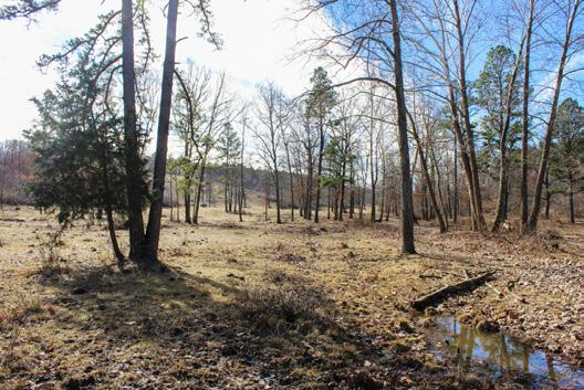
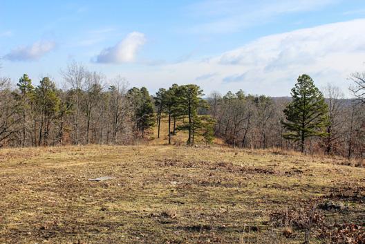
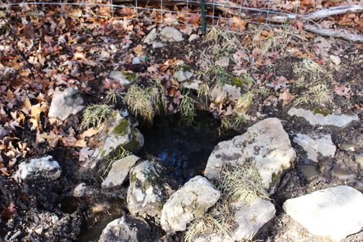
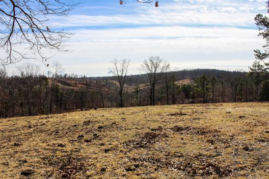
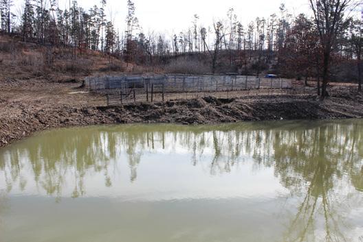
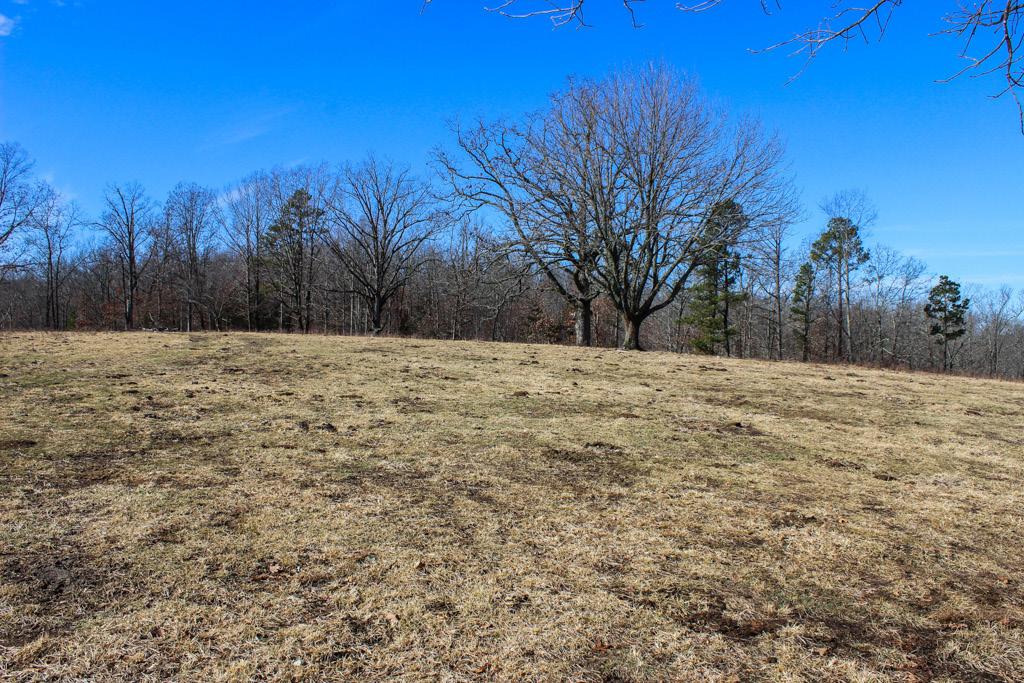
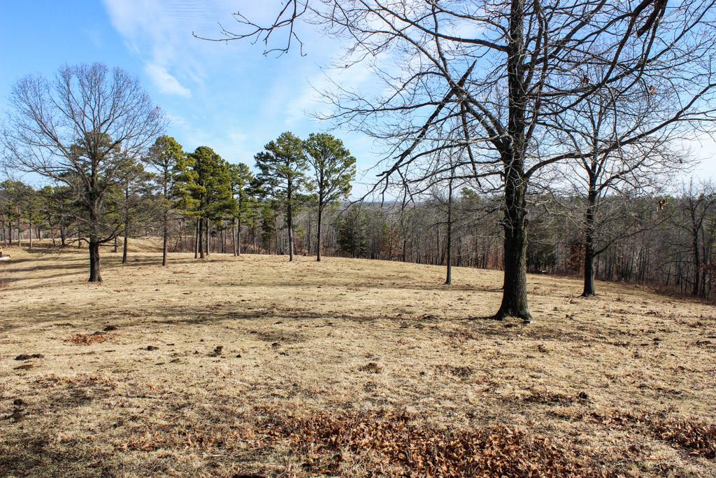
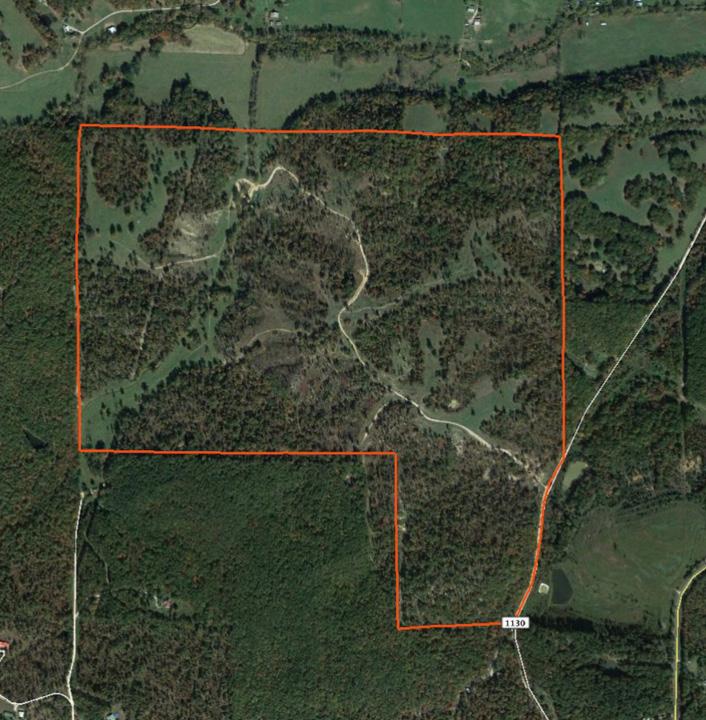
2 ACRES ACRES- -COUNTY, HOWELLSTATE COUNTY, MO Grazing Ground with Endless Options The cleared bottoms and ridge tops, rolling wooded draws, and several ponds and springs on this property offer endless options for this property. Located just minutes from Willow Springs, the cleared ridge tops with their spectacular views, offer a great future build site. Currently, the cleared acreage, seeded with fescue and recently lime fertilized, is being used as grazing for nearly 60 head of cattle. There are 7 ponds and 5 springs, creating lots of watering options. Cattle tight perimeter fencing is in place around the entire property and the acreage is estimated to be 65% open, with more clearing planned this Spring. The wooded draws create natural travel corridors for the whitetail deer, and the wet weather creek running through the bottoms is a perfect habitat for large groups of turkey. The property owner reports great hunting, having harvested several deer and turkey every year. This property is also rich in history, with Old Rolla Road lacing through the bottoms. The road leads to a spring on the property that has thought to have watered soldiers and horses during the Civil War. Fantastic build sites, grazing ground for cattle, and great hunting give this property plenty of options for the new owner. The seller is also willing to negotiate a turn key price that would include cattle, cattle panels, tractor, and dozer. Call today for more information, Cleared bottoms and ridge tops perfect for grazing cattle Excellent hunting with the wooded draws and open bottoms Multiple springs and ponds creating plenty of watering options Rich in history with Old Rolla Road lacing the property Cattle tight perimeter fencing 3 miles from Willow Springs, MO Incredible ridge top views for future build sites Around 65% open with more being cleared this Spring Turn-key operation negotiable including cattle and equipment Clearings have been planted in fescue, limed, and fertilized

3


4 ACRES ACRES- -COUNTY, HOWELLSTATE COUNTY, MO
5

6 ACRES - - COUNTY, HOWELL STATE COUNTY, MO

7 Topography Map map center: 37 2' 18.7, ' ft 712ft 1424ft 7-27N-9W Howell County Missouri 1/8/2018

8 ACRES - - COUNTY, HOWELL STATE COUNTY, MO Aerial Map map center: 37 2' 18.7, ' ft 712ft 1424ft 7-27N-9W Howell County Missouri 1/8/2018


9 Soils Map State: Missouri County: Howell Location: 7-27N-9W Township: Willow Springs Acres: 279 Date: 1/8/2018 Soils data provided by USDA and NRCS. Area Symbol: MO091, MO091, Soil Soil Area Area Version: Version: Code Soil Description Acres Percent of field Non Irr Class Legend Non Irr Class *c Alfalfa hay Caucasian bluestem Common bermudagrass Orchardgrass red clover Tall fescue Warm season grasses Winter wheat Tick extremely gravelly silt loam, 15 to 50 percent slopes, very stony Tick very gravelly silt loam, 3 to 15 percent slopes, stony Cedargap very gravelly silt loam, 1 to 3 percent slopes, occasionally flooded Clarksville Tick Mano complex, rocky, 15 to 50 percent slopes Secesh Tilk complex, 1 to 3 percent slopes, occasionally flooded Tick very gravelly silt loam, 3 to 8 percent slopes Secesh silt loam, 0 to 2 percent slopes, rarely flooded % VIIe % IVe % IIIs % VIIe % IIw % IVe % IIIs *c: Using Capabilities Class Dominant Condition Aggregation Method Weighted Average Soils data provided by USDA and NRCS.
Demoss Farm & Home 118 Acres, M/L W. 209th Ave. Pattonsburg, Mo 64670
 118 Acres, M/L 39436 W. 209th Ave. Pattonsburg, Mo 64670 PRICE: $400,000.00 LAND USE: FSA shows approx. 118.32 farmland acres, ml, of which there were 36.47 acres of effective cropland with the remainder
173 ACRES - RILEY COUNTY, KS
 Buyers, Sellers & Land Connected PRICE: $690,000 ACRES: 173 COUNTY: RILEY STATE: KANSAS First Class Hunting with Outstanding Income Potential If you have ever dreamed of owning your very own piece of first
131 ACRES M/L VAN BUREN COUNTY, IOWA LISTING #458 JIM KEDLEY. C: O:
 131 ACRES M/L VAN BUREN COUNTY, IOWA LISTING #458 JIM KEDLEY C: 563-212-5401 O: 563-659-8185 Jimkedley@totalrealtyco.com CWC Holdings LLC, 131 Acres M/L, Van Buren County, IA TOTAL ACRES: 131 MOL PRICE:
FARMLAND AUCTION. FSA INFORMATION: Farmland: acres Cropland: acres Tillable: acres
 FARMLAND AUCTION January 22, 2019 at 10:30 am Keep an eye on BarnesRealty.com for possible blizzard date of 1/24/2019 Fisher Community Center, 201 E. Iowa St. Hiawatha, KS 66434 Here is a very productive
State: Kansas County: Sherman Location: S-037W Township: Union Acres: Date: 12/19/2011. Maps provided by:
 Soils Map State: Kansas County: Sherman Location: 007-009S-037W Township: Union Acres: 147.8 Date: 12/19/2011 Fsa borders provided by the Farm Service Agency as of May 23, 2008. Soils data provided by
LAND FOR SALE 30 ACRES M/L FLOYD COUNTY, IOWA LISTING # DOUGLAS R. YEGGE C: O:
 LAND FOR SALE LISTING #13886 30 ACRES M/L FLOYD COUNTY, IOWA DOUGLAS R. YEGGE C: 563-320-9900 O: 563-659-8185 Doug@PeoplesCompany.com ALAN MCNEIL C: 563-321-1125 O: 563-659-8185 Alan@PeoplesCompany.com
Aerial Map. map center: 38 0' 55.53, ' S-4E Franklin County Illinois
 Aerial Map map center: 38 0' 55.53, -88 42' 58.78 0ft 594ft 1188ft 11/24/2016 Field borders provided by Farm Service Agency as of 5/21/2008. Soils data provided by University of at Champaign-Urbana. Topography
FOR SALE NEW PRICE HILL FAMILY FARM WATKINS CORNER, AR. Phillips County, Arkansas: 2,300+/- Acre Irrigated Grain Farm NEW PRICE/YIELD UPDATES:
 NEW PRICE FARMLAND ADVISORS FOR SALE HILL FAMILY FARM WATKINS CORNER, AR 2,300+/- Acres - Phillips County, Arkansas $10,950,000 Phillips County, Arkansas: 2,300+/- Acre Irrigated Grain Farm NEW PRICE/YIELD
LAND FOR SALE 314 ACRES M/L BERG, WORTH COUNTY, IOWA LISTING # DOUGLAS R. YEGGE C: O:
 LAND FOR SALE LISTING #13870 314 ACRES M/L BERG, WORTH COUNTY, IOWA DOUGLAS R. YEGGE C: 563-320-9900 O: 563-659-8185 Doug@PeoplesCompany.com ALAN MCNEIL C: 563-321-1125 O: 563-659-8185 Alan@PeoplesCompany.com
80 ACRES M/L CEDAR COUNTY, IA LISTING #465 DOUGLAS R. YEGGE ALAN MCNEIL. C: O:
 80 ACRES M/L CEDAR COUNTY, IA LISTING #465 DOUGLAS R. YEGGE C: 563-320-9900 O: 563-659-8185 total@totalrealtyco.com ALAN MCNEIL C: 563-321-1125 O: 563-659-8185 alan@totalrealtyco.com Kroemer, 80 Acres
FOR SALE HILL FAMILY FARM WATKINS CORNER, AR. Phillips County, Arkansas: 2,300+/- Acre Irrigated Grain Farm NEW PRICE/YIELD UPDATES:
 SOLD FARMLAND ADVISORS FOR SALE HILL FAMILY FARM WATKINS CORNER, AR 2,300+/- Acres - Phillips County, Arkansas $10,950,000 Phillips County, Arkansas: 2,300+/- Acre Irrigated Grain Farm NEW PRICE/YIELD
Deuel County Dryland
 Deuel County Dryland Two parcels of dryland farm ground near Lewellen, NE Property Highlights List Price $852,474 $786,877 Location 12-15 miles south of Lewellen, Ne or the same distance from Big Springs,
LAND FOR SALE 82 ACRES M/L CEDAR COUNTY, IOWA LISTING # DOUGLAS R. YEGGE C: O:
 LAND FOR SALE LISTING #13968 82 ACRES M/L CEDAR COUNTY, IOWA DOUGLAS R. YEGGE C: 563-320-9900 O: 563-659-8185 Doug@PeoplesCompany.com ALAN MCNEIL C: 563-321-1125 O: 563-659-8185 Alan@PeoplesCompany.com
365.8 Acres +/- Brown County, KS February 28, 2019 at 10:30 am Community Building, 511 West Front Street, Fairview, KS
 Farmland Auction February 28, 2019 at 10:30 am Community Building, 511 West Front Street, Fairview, KS This excellent Brown County farm is just North of Fairview, KS and it will be selling in 3 tracts
80 ACRES M/L BOONE COUNTY, IOWA LISTING # Pilot Mound, Iowa. I Avenue. 130th Street. Co Hwy P th Street
 Co Hwy P70 I Avenue 80 ACRES M/L BOONE COUNTY, IOWA CAPTION Pilot Mound, 130th Street 130th Street LISTING #12320 New Listing Price! $800,000 DESCRIPTION: High Quality Farm in Strong Farming Area and potential
PRICE: $441,000. Buyers, Sellers & Land Connected 210 ACRES - ST. CLAIR COUNTY, MO ACRES: 210 COUNTY: ST. CLAIR STATE: MISSOURI
 Buyers, Sellers & Land Connected 210 ACRES - ST. CLAIR COUNTY, MO PRICE: $441,000 ACRES: 210 COUNTY: ST. CLAIR STATE: MISSOURI A Life Time of Adventures Await Not far from where the Osage and Sac Rivers
WALKER FEEDLOT Total taxable acres, part fenced. 4 homes & multiple nice/modern outbldgs hd feedyard with sprinklers a-shkd-0002
 ABILENE WALKER FEEDLOT 38.7 Total taxable acres, part fenced 4 homes & multiple nice/modern outbldgs 3500 hd feedyard with sprinklers a-shkd-0002 Center pivot irrigation from lagoons 999 hd feedlot A-SHDK-B020
Northeast Perkins County Pivots
 Northeast Perkins County Pivots 315.9± acres of center pivot irrigated farmland Southeast of Paxton, NE Email: Jordan@lashleyland.com Property Highlights List Price $1,550,000 Location Southeast of Paxton,
+/- 60 AC LAND FOR SALE HARLEY ROAD, ELBURN, IL 60119
 Land For Sale OFFERING SUMMARY Sale Price: $660,000 Price / Acre: $11,000 PROPERTY OVERVIEW +/- 60 acres available for purchase on the west side of Harley Road, South of Rt. 38. This site has Harley Road
Warm Season Perennial Grasses for Forage in Kentucky
 AGR-145 Warm Season Perennial Grasses for Forage in Kentucky Monroe Rasnake, Department of Agronomy Jimmy Henning, Department of Agronomy David Stipes, USDA Natural Resources Conservation Service Warm
Auction Location Eagles Club 316 S. 2 nd Street, Aberdeen, SD
 Auction Location Eagles Club 316 S. 2 nd Street, Aberdeen, SD Welcome We would like to invite and welcome you to our public auction! This is an excellent opportunity to add Brown County cropland to your
Land Sales Specialists Setting the trend for how Real Estate is sold in the Midwest.
 Land Sales Specialists Setting the trend for how Real Estate is sold in the Midwest. www.barnesrealty.com 18156 Hwy 59 Mound City, MO 64470 (660) 442-3177 1711 Oregon Hiawatha, KS 66434 (785) 742-4580
FOR SALE ± ACRES VALENTINES, VIRGINIA Price: $150,000
 LATITUDE & LONGITUDE 36.566924, -77.764781 Features STRONG RECREATIONAL INVESTMENT opportunity located south of Triplet with access from VSR 600 (Triplet Rd.) to the north. TRACT HAS BEEN RECENTLY CUTOVER
Farmland For Sale 3 Tracts /- acres Webster County, Iowa Section 31, T88N, R30W & Section 33, T88N, R29W
 Farmland For Sale 3 Tracts 316.02 +/- acres Webster County, Section 31, T88N, R30W & Section 33, T88N, R29W Contact Martin today! 309-242-7299 mthornton@hbtbank.com Martin G. Thornton, Broker 200 W. College
Harding Real Estate Vacant Acres Thompson Rd., Woodstock, IL
 Harding Real Estate 325.31 Vacant Acres Thompson Rd., Woodstock, IL Randy Erwin, Broker Associate Natalie Torres, Broker Associate BHHS Starck Real Estate 1710 South Eastwood Dr. Woodstock, IL. 60098 Randy@RandyErwin.com
Sacramento River Farmland Anderson, California
 AG-LAND INVESTMENT BROKERS 275 Sale Lane / P. O. Box 896 Red Bluff, CA 96080 530.529.4400 office / 530.527.5042 fax Sacramento River Farmland Anderson, California Property: 43 +/- acres of farmland with
LAND FOR SALE. Beautiful Farmstead. Pifer s. Price: $1,250, /- Acres Green County, WI
 Beautiful Farmstead LAND FOR SALE 176 +/- Acres Green County, WI Price: $1,250,000 Auction & Realty - Robert Scott Pifer, Broker (#56685-90) RE Entity License #937110-91, Auction Company License #429-53
G T12 G J44 G J46 ST 2. Jerome. Martinstown. Numa. A Maryanna F. Wallin Estate Appanoose County, Iowa
 135th Ave 150th Ave 153rd Ave Elm St N 170th Ave 171st Ave 172nd St 175th Ave 51 0th St Highw ay 2 Highw ay 2 ST 2 Highw ay 2 G T12 135th Ave 522nd St 523rd St Jerome 140th Ave 524th St 1 2 G J44 3 160th
TP73 4PTP101 TP45 TP9 TP74 TP46 TP47 TP115 TP48 TP32 TP5 TP31 TP22 TP49 V58 TP57 4F TP50 TP51 3PD 3PD TP80 TP28 TP55
 Figure 2.1-3 - Capability Assessment Map Part of Lots 18 and 19, Concession 3 Township of Russell sified unclas TP72 TP90 TP624P V18 3D TP35 TP73 4PTP101 3D TP45 TP9 TP74 TP89 TP117 V61 V34 TP19 TP20 TP100
SW CORNER ROUTE 38 AND HARLEY ROAD SW CORNER ROUTE 38 & HARLEY ROAD, KANE COUNTY, IL 60119
 REDUCED: Land For Sale SW CORNER ROUTE 38 AND HARLEY ROAD REDUCED: 124 AC ON IL ROUTE 38 OFFERING SUMMARY Sale Price: $1,643,000 Price / Acre: $13,250/AC PROPERTY OVERVIEW This 124 AC parcel has approximately
STATE TAX COMMISSION OF MISSOURI ASSESSOR MANUAL
 STATE TAX COMMISSION OF MISSOURI ASSESSOR MANUAL CHAPTER: REVISION DATE: 10/1/2008 Page 1 of 18 7.3 The purpose of this section of the Assessor s Manual is to supplement the State Tax Commission s published
Area 3 Envirothon Soils Questions Key
 Area 3 Envirothon Soils Questions Key 1. Soil aeration is the exchange of air in soil with air from the atmosphere. When a soil is well aerated, the air within the soil is very similar to the atmosphere
RED LODGE CREEK SHANE RIDGE RANCH
 RED LODGE CREEK SHANE RIDGE RANCH Roberts, Montana 59070 For additional details, contact: SCOTT R. GROSSKOPF Broker / Owner Member Landmark of Billings 1925 Grand Avenue, Ste. 144, Billings, MT 59102 Office:
Farmland Classification Centre County, Pennsylvania (Student Farm Site) Web Soil Survey National Cooperative Soil Survey
 Web Soil Survey National Cooperative Soil Survey") 256300 256600 256900 257200 257500 257800 258100 77 51' 20'' W 77 53' 26'' W Farmland Classification Centre County, Pennsylvania 258400 258700 259000 40 49' 4'' N 4520600 4520900 4520900 4521200 4521200
256300 256600 256900 257200 257500 257800 258100 77 51' 20'' W 77 53' 26'' W Farmland Classification Centre County, Pennsylvania 258400 258700 259000 40 49' 4'' N 4520600 4520900 4520900 4521200 4521200
Land for Sale. Baker County, Georgia. $4,960,000 1,984 Acres $2,500 per Acre
 Land for Sale Baker County, Georgia $4,960,000 1,984 Acres $2,500 per Acre 2 Contents Property Fact Sheet... 3 Regional Map... 4 Local Map... 5 Aerial Map... 6 Major Soil Types Map... 7 Soil Classification
FOR SALE 280.5± ACRES SUSSEX COUNTY, VA Price: $430,000
 LATITUDE & LONGITUDE 37.5556, -79.2318 Winchester Front Royal 15 Leesburg 495 Washington 66 Chantilly Arlington Falls Church Fairfax Alexandria Springfield Manassas Warrenton 301 13 113 Dale City Waldorf
268 Acres m/l, Iowa County, IA. Offered in 2 Remaining Parcels. Parcel Ac. m/l Parcel 2-81 Ac. m/l Parcel 3-45 Ac. m/l - SOLD!
 LAND FOR SALE 268 Acres m/l, Iowa County, IA Offered in 2 Remaining Parcels Parcel 1-187 Ac. m/l Parcel 2-81 Ac. m/l Parcel 3-45 Ac. m/l - SOLD! Golden Grain Enterprises Good Iowa County Farms Located
Chapter 11 Site Rehabilitation and Stabilization
 Chapter 11 Site Rehabilitation and Stabilization Chapter 11 Layout: Part 1 - Page 131 Planning Site Rehab Part 2 - Page 132 Controlling Runoff and Capturing Sediment Part 3 - Page 133 Rehab for Crossings
2016 Iowa FFA Soils Evaluation CDE Exam
 2016 Iowa FFA Soils Evaluation CDE Exam 1. Which of the following is true regarding soil horizons? a. A horizon is darker in color and has more organic matter b. B horizon is darker in color and has more
Soils and Land Use Test
 SOIL PROPERTIES Total Score /50 1) List two of the five main functions of soil. (2 points) Habitat for organisms, Engineering medium, Filters and stores water, Anchor for plants, Cycles nutrients 2) Small
Richfield Prunes, Pistachios & Walnuts
 AG-LAND Investment Brokers 275 Sale Lane Red Bluff, CA 96080 530-529-4400 Fax 530-527-5042 Richfield Prunes, Pistachios & Walnuts 210 +/- acres 3 Parcels Corning, CA - Tehama County jsubject AG-LAND
Yates Cattle & Conservation Ranch
 Yates Cattle & Conservation Ranch Yates Cattle and Conservation Ranch 385 +/- acres Hays & Travis Counties, Texas James King, Agent Office 432.426.2024 James@KingLandWater.com Location There is a property
& Tips for Habitat Improvement. Wild Turkey Biologist, Pennsylvania Game Commission
 The Wild Turkey, its Habitat & Tips for Habitat Improvement Mary Jo Casalena Wild Turkey Biologist, Pennsylvania Game Commission i Hen Gobbler Bearded Hen 0 33% of hens Depends on area Pencil thin < 8
Umatilla River $1,650,000
 Forth Ranch Umatilla River $1,650,000 The Whitney Land Company Robin Fletcher, Broker 101 S.E. Third, Pendleton, OR 97801 (541) 278-4444; farms@whitneylandcompany.com www.whitneylandcompany.com This property
Land Capability Class
 Guide for Applying Conservation Treatments for Land Evaluation (5/23/2011) LAND TREATMENT After examining and determining the physical features of the soil profile, one can determine the land capability
Colusa County Almonds
 Morgan Houchin. 3430 Unicorn Road Bakersfield, CA 93308 mobile office efax 526.97 +/- Acres of Colusa County Almonds Cork McIsaac, Broker. Broker License No. 01216717 P.O. Box 1076 West Sacramento, CA
RaC. RaD GlG. GlF. RaD GlE. CeA. RaE. RcD. GoF. GoF SkC. SkD. CfA. AdA. GoF. GoF. GoF. RcD. GgD. GoF. RaE GlE. RaE DbF. GoF. DbE. RaC.
 526300 527400 528500 529600 530700 531800 532900 534000 535100 4240200 4241300 4242400 4243500 4244600 4245700 ADRIAN DR FAIRWAY DR STATE FARM DR DOLORES DR HUDIS ST SANTA ALICIA DR Cotati PAGE ST ALTA
Kansas State Agricultural College SWEET CLOVER.
 Kansas State Agricultural College EXPERIMENT STATION Circular No. 34. DEPARTMENT OF AGRONOMY L. E. Call, Agronomist in Charge SWEET CLOVER. By C. C. CUNNINGHAM. SWEET CLOVER is destined to occupy an important
PLANTING GUIDE TO GRASSES AND LEGUMES
 PLANTING GUIDE TO GRASSES AND LEGUMES for Forage and Wildlife in Georgia Reviewed by Dennis W. Hancock, PhD. Prepared by R. Dewey Lee, PhD. This planting guide will help producers establish grasses and
Tract 1. Tract 3. Tract 2. Tract 4. A Taylor Co., IA
 Newport Ave Sec. 7 Sec. 8 235th St Sec. 13 250 th St Sec. 18 Maryl and Ave Sec. 17 T68N R34W T68N R33W 250 th St Sec. 24 257t h St Sec. 19 2 Newp ort Way Sec. 20 Sec. 25 Latitude: 40.6872 N Longitude:
Limpia Creek Duck Pond. 25 acres, Jeff Davis County
 Limpia Creek Duck Pond 25 acres, Jeff Davis County Limpia Creek Duck Pond Hwy 17 N, 25 acres Jeff Davis County, Texas James Tammy King, Agent Broker Office King Land 432 & 426.2024 Water, LLC 432 426.2024
Yields of Non-Irrigated Crops (Component): Soybeans (Bu) Edgecombe County, North Carolina, and Halifax... (SOYBEANS)
: Soybeans (Bu) Edgecombe County, North Carolina, and Halifax... (SOYBEANS)") 77 37' 52'' W Yields of Non-Irrigated Crops (Component): Soybeans (Bu) Edgecombe County, North Carolina, and Halifax... () 77 36' 28'' W 263300 263600 263900 264200 264500 264800 265100 36 6' 59'' N 36
77 37' 52'' W Yields of Non-Irrigated Crops (Component): Soybeans (Bu) Edgecombe County, North Carolina, and Halifax... () 77 36' 28'' W 263300 263600 263900 264200 264500 264800 265100 36 6' 59'' N 36
EROSION & SEDIMENT CONTROL
 EROSION & SEDIMENT CONTROL Surface Water Protection During Well Site Construction Kelly Kees, PE WVDEP, Office of Oil and Gas SEDIMENT & EROSION CONTROL PLANS Per West Virginia State Code 22-6-6(d) 22-6A-7(c),
Unit II Soil Management
 Unit II Soil Management Lesson 2: Using Soil Survey Manuals Soil survey manuals provide useful information for grassland management. Soil scientists evaluate the soil for chemical and physical properties,
Step 1: Equipment. Step 2: Choosing the Site
 Step 1: Equipment Tools you use can range from a garden tiller at one end to a 40-50 HP tractor at the other extreme. ATVs fill in a strong spot between these two, allowing you to work a much larger area
Arkansas Agronomy Technical Note 1 Conservation Practice Seeding Recommendations February 1, 2014
 Arkansas Agronomy Technical Note 1 Conservation Practice Seeding Recommendations February 1, 2014 Introduction This technical note may be used to develop site specific recommendations for Arkansas NRCS
Soils and their Relationship with Agriculture
 Soils and their Relationship with Agriculture Presentation created by Thomas Gallagher Modified by Hank Bignell Capital Area Agriculture and Horticulture Program Cornell University Cooperative Extension
For Sale at $290,000.00
 We are pleased to present Stearns Property 77± Acres Forest Township, Rice County For Sale at $290,000.00 Listing Agent: Charles Wingert Office: 507-345-LAND (5263) Toll Free: 800-730-LAND (5263) Direct:
Land Capability Classifications
 Land Capability Classifications Unit: Soil Science Problem Area: Basic Principles of Soil Science Student Learning Objectives. Instruction in this lesson should result in students achieving the following
Plan Review Checklist
 Plan Review Checklist FOR EROSION AND SEDIMENT CONTROL PLANS _ Minimum Standards - All applicable Minimum Standards must be addressed. All minimum Standards must be adhered to during the entire project
Pifer s. 1, /- Acres Clay County, MN. Written Bid. Land For Lease. WRITTEN BIDS DUE BEFORE: Friday, January 19, :00 p.m.
 1,666.53 +/- Acres Clay County, MN Written Bid Land For Lease WRITTEN BIDS DUE BEFORE: Friday, January 19, 2018 5:00 p.m. OWNER: Hogetvedt Family Rev Trust STOCK PHOTO General Information Land Lease Auction
Missouri State Envirothon Challenge Wildlife Ecostation. Sept - Late Oct.
 Missouri State Envirothon Challenge Wildlife Ecostation Wildlife Warm Season Grass Area WI. (6 points) Identify the three species of native grasses provided. Big Bluestem, Indian grass, Switchgrass W2.
Sioux County Hideaway
 Sioux County Hideaway A one of a kind ranch with 160± acres sitting 20 miles NW of Crawford, NE. Property Highlights List Price $425,000 Location 20 miles NW of Crawford, NE Legal Description 29 33 53
POST CONSTRUCTION STORMWATER MANAGEMENT FOR "WHITE OAK SEWER INTERCEPTOR"
 POST CONSTRUCTION STORMWATER MANAGEMENT PLAN FOR "WHITE OAK SEWER INTERCEPTOR" Located in Newberry Township, York County March 21, 2008 Prepared by: Mellott Engineering, Inc. 7500 Devonshire Heights Road
Bull Canyon Ranch 2750 BULL CANYON ROAD, SANTA MARIA, CALIFORNIA PRESENTED FOR SALE BY: Rincon corporation
 Bull Canyon Ranch 2750 BULL CANYON ROAD, SANTA MARIA, CALIFORNIA PRESENTED FOR SALE BY: Rincon corporation THE FULL SERVICE REAL ESTATE COMPANY FOR THE AGRICULTURAL COMMUNITY Bull canyon ranch, santa maria
Development. Within of 25% or greater. ridges anticipated that the. foundations. and walk out. Page 1 of 4
 Ridge Estates May 11, 2016 LAND SUITABILITY ANALYSIS REPORT 1. INTRODUCTION This report is provided in accordance with the submittal requirements of the Planned Development Plan (PPD). The report accompanies
Grassland. Grassland Food Web
 Grassland Grassland Food Web An ecosystem that is dominated by grasses; some types of grasslands include campos, meadow, pampas, prairie, savanna, steppe, and yield. Grasses Big Bluestem was the chief
Project: Developer/Designer: Reviewer: I. Narrative: 1. Project Description: Describes the nature and purpose of the land disturbing activity.
 City of Charlottesville, Virginia Erosion and Sediment Control Plan Review Checklist 610 East Market Street, Charlottesville, VA 22902 Telephone 434-970-3182; Fax 434-970-3359 Project: Developer/Designer:
MONROE COUNTY PROPOSED RECLAMATION PLAN
 MONROE COUNTY PROPOSED RECLAMATION PLAN SITE NAME: Purpus Quarry GENERAL INFORMATION: Operator Name/Address: The Kraemer Company, LLC 820 Wachter Avenue P.O. Box 235 Plain, Wisconsin 53577 (608) 546-2255
Conservation Plan. I. Property Information. II. Objectives. Natural Resource Objectives. Sustainability in Practice (SIP) Certified
 Certified") Conservation Plan Sustainability in Practice (SIP) Certified I. Property Information Vineyard Name and Establishment Date: Location: Map (attach showing blocks and acres): II. Objectives Natural Resource
Conservation Plan Sustainability in Practice (SIP) Certified I. Property Information Vineyard Name and Establishment Date: Location: Map (attach showing blocks and acres): II. Objectives Natural Resource
Custom Soil Resource Report Soil Map
 77 11' 22'' W Custom Soil Resource Report Soil Map 77 9' 43'' W 36 48' 13'' N 304700 304900 305100 305300 305500 305700 305900 306100 306300 306500 306700 306900 307100 36 48' 13'' N 36 47' 21'' N 4073800
ROSE CREEK RANCH WINNEMUCCA, NV HUMBOLDT AND PERSHING COUNTY
 ROSE CREEK RANCH WINNEMUCCA, NV HUMBOLDT AND PERSHING COUNTY Industrial & Residential Development Site I-80 frontage @ Hwy 40 interchange Heart of Nevada Gold Country 2,743 acres Enjoy hunting, farming
Development. Within of 25% or greater. ridges anticipated that the. foundations. and walk out. Page 1 of 4
 Ridge Estates May 11, 2016 LAND SUITABILITY ANALYSIS REPORT 1. INTRODUCTION This report is provided in accordance with the submittal requirements of the Planned Development Plan (PPD). The report accompanies
EXPERIMENT 6 PREPARATION OF LAND CAPABILITY CLASS MAP
 EXPERIMENT 6 PREPARATION OF LAND CAPABILITY CLASS MAP Structure 6.0 Objectives 6.1 Intnxluction 6.2 Experiment 6.21 Deciding Factors for Land Capability 6.2.2 Requirements 6.23 Procedure 6.3 Observations
Check the wildlife management practices implemented on the property during the year being reported. A minimum of three practices is required.
 1-D-1 Open Space Agricultural Valuation Wildlife Management Annual Report for the Year(s) Submit this plan to your County Tax Appraiser, not to Texas Parks and Wildlife Department Part I Owner Information
 108 40' 29'' W Soil Map Mesa County Area, Colorado 108 36' 55'' W 39 10' 11'' N 39 6' 31'' N 4331700 4332500 4333300 4334100 4334900 4335700 4336500 4337300 4338100 701100 701900 702700 703500 704300 705100
Everett Prune Farm Glenn County, California
 Everett Prune Farm Glenn County, California Proudly Offered By 707 Merchant Street, Suite 100, Vacaville, Ca 95688 (707) 455-4444 Office (707) 455-0455 Fax info@caoutdoorproperties.com www.californiaoutdoorproperties.com
PLANTING GUIDE TO GRASSES AND LEGUMES
 PLANTING GUIDE TO GRASSES AND LEGUMES for Forage and Wildlife in Georgia Reviewed by Dennis W. Hancock, PhD. Prepared by R. Dewey Lee, PhD. This planting guide will help producers establish grasses and
Horse Lovers Dream Facility. 351 Cactus Rio Drive ~ Weatherford, TX. Stephen Reich Mobile: Fax:
 ~ Weatherford, TX PROPERTY SUMMARY 6.230 Acres 8.490 Additional Acres Available Custom 4,080 sq ft Farm and Ranch home Location: Conveniently located in the Heart of the Cutting Capital. From Weatherford,
Mike Lashley Owner Broker Mike s Cell:
 Hershey Equine, Cattle & Wildlife Ranch A fantastic cattle and wildlife property with a beautifully renovated home Property Highlights List Price $790,000 $745,000 Location Legal Description See Exhibit
Dryland Grasses and Misc. Forages
 Dryland Grasses and Misc. Forages Bluegrass, Canada This grass is used largely as a low-maintenance ground cover that can get up to 18 in moderately acidic soils. The optimal minimum rainfall requirement
Custom Soil Resource Report for Craighead County, Arkansas
 United States Department of Agriculture Natural Resources Conservation Service A product of the National Cooperative Soil Survey, a joint effort of the United States Department of Agriculture and other
2016 Area 3 Envirothon Muskingum County Soils Test ANSWER KEY
 2016 Area 3 Envirothon Muskingum County Soils Test ANSWER KEY 1. The majority of the bedrock in Muskingum County is. a. sedimentary bedrock b. glacial bedrock c. igneous bedrock d. metamorphic bedrock
Land for Sale. Marion County, Georgia. $2,160,000 +/- 900 Acres $2,400 per Acre
 Land for Sale Marion County, Georgia 2 Contents Property Fact Sheet... 3 Regional Map... 4 Local Map... 5 Aerial Map... 6 Major Soil Types Map... 7 Soil Classification Map... 8 Soil Classification Table...
Cedar Niles Future Park Site Wetland #1
 Date: October 20, 2014 Site: Landowner: Johnson County Parks Designer: Thomas R. Biebighauser Individuals Present: Thomas R. Biebighauser, Dr. Eliodora Chamberlain (US EPA), Jason Daniels (US EPA), Jeannette
recreational areas, room with the outdoors.
 250 Acre Equine Showplace Robertson County, TX This gentleman s ranch is the ultimate in horse property or cattle ranching in Robertson and surrounding counties. This beautiful ranch features rolling,
REQUIREMENTS FOR SUCCESSFUL ALFALFA ESTABLISHMENT
 REQUIREMENTS FOR SUCCESSFUL ALFALFA ESTABLISHMENT Garry D. Lacefield Extension Forage Specialist University of Kentucky Establishing a good stand of alfalfa is expensive and time consuming, but the success
Producing and Scavenging Nitrogen with Cover Crops
 Producing and Scavenging Nitrogen with Cover Crops Placed 450+ Cover Crop Plots in 6 states in 2009 2013 Producing Nitrogen with Cover Crops Several Legumes make very good cover crops How much N can they
A. E. ALDOUS GENERAL CHARACTERISTICS
 KOREAN LESPEDEZA 1 A. E. ALDOUS GENERAL CHARACTERISTICS Korean lespedeza, an annual legume with very fine stems, is a comparatively new crop in Kansas. It is closely related to the small Japanese lespedeza
Surface Coal Mining and Reclamation in ND. Guy Welch ND Public Service Commission
 Surface Coal Mining and Reclamation in ND Guy Welch ND Public Service Commission Surface Coal Mines in North Dakota Approximately 1500 acres are disturbed each year History of Reclamation in ND First surface
The analysis area for the scenic resource is the project area described in Chapter 1. Affected Environment/Existing Condition
 Chapter 3 - Scenic Resource SCENIC RESOURCES Introduction The Spotted Bear Ranger District is a destination point for outdoor recreation activities and offers a variety of recreation opportunities: driving
Friendly Persuasion Farm
 Friendly Persuasion Farm 1061 White Pine Flats Troy, Idaho $975,000 Overview Specifically designed as a pilot and horse-lover s dream, this 173 +/- acre property is a gem in Northern Idaho. Features include
Can this really be New Mexico?? YES!! This ranch has a lake of about acres in size (above).
.") Can this really be New Mexico?? YES!! This ranch has a lake of about 15-20 acres in size (above). A fabulous custom log home overlooks the hay meadows where deer, elk, and wild turkey come to munch on
Can this really be New Mexico?? YES!! This ranch has a lake of about 15-20 acres in size (above). A fabulous custom log home overlooks the hay meadows where deer, elk, and wild turkey come to munch on
Erosion Control for Home Builders in the. City of Jacksonville
 Erosion Control for Home Builders in the City of Jacksonville Eroding construction sites are a leading cause of water quality problems in Jacksonville. For every acre under construction, about a dump truck
MOWING AND WILDLIFE: MANAGING OPEN SPACE FOR WILDLIFE SPECIES
 PENNSYLVANIA GAME COMMISSION MOWING AND WILDLIFE: MANAGING OPEN SPACE FOR WILDLIFE SPECIES Many property owners want clean-cut, attractive lawns or fields. However, what appears to be a healthy lawn to
The proper use of erosion and sediment controls will allow the following objectives to be met:
 Chapter 5 5.0 Introduction During construction activities, soil is typically moved or disturbed in a way that affects stormwater drainage. The use of Best Management Practices (BMPs) during construction
Title: Lecture 16 Soil Water and Nutrients Speaker: Teresa Koenig Created by: Teresa Koenig, Kim Kidwell. online.wsu.edu
 Title: Lecture 16 Soil Water and Nutrients Speaker: Teresa Koenig Created by: Teresa Koenig, Kim Kidwell online.wsu.edu Photos courtesy of Rich Koenig Photos courtesy of USDA NRCS Soil Water and Nutrients
A GUIDE FOR LAND JUDGING IN MICHIGAN. D. L. Mokma, E. Dersch and D. Kesselring
 A GUIDE FOR LAND JUDGING IN MICHIGAN D. L. Mokma, E. Dersch and D. Kesselring Michigan State University in cooperation with the Michigan Chapter of the Soil and Water Conservation Society The study of
September 20, 2016 Soils Investigation for Agricultural Designation Windemere Place, Missoula County, Montana
 September 20, 201 Soils Investigation for Agricultural Designation Windemere Place, Missoula County, Montana The purpose of this report is to compare on-site soils of the proposed subdivision with the
Custom Soil Resource Report for Clark County, Missouri
 United States Department of Agriculture Natural Resources Conservation Service A product of the National Cooperative Soil Survey, a joint effort of the United States Department of Agriculture and other