WALKER FEEDLOT Total taxable acres, part fenced. 4 homes & multiple nice/modern outbldgs hd feedyard with sprinklers a-shkd-0002
|
|
|
- Percival Watkins
- 6 years ago
- Views:
Transcription

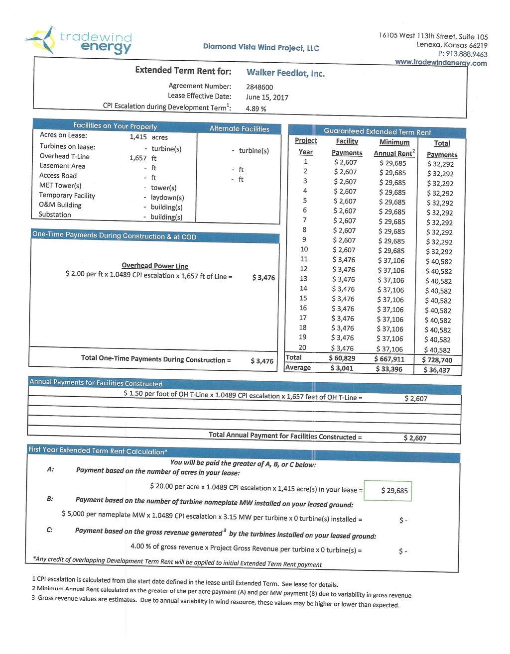
1 ABILENE WALKER FEEDLOT 38.7 Total taxable acres, part fenced 4 homes & multiple nice/modern outbldgs 3500 hd feedyard with sprinklers a-shkd-0002 Center pivot irrigation from lagoons 999 hd feedlot A-SHDK-B020 Excellent water > Excellent drainage Excellent Trench Silo and Grain Storage $728,740 Wind Energy Agreement for transmission lines 629 Ac+/- 157 Ac+/- 284 Ac+/999 feedlot 1 home 122 Ac+/ Ac+/ Ac+/1 home Acreage Breakdown 38.7 taxable Ac+/ FSA 3500 hd feedlot tillable 2 homes & bldgs pasture water ways 62 Feedlot houses Ac+/- Tampa 4 miles South
2 Walker Feedlot Water Well Information Head Quarters 3500 hd feedlot Permit # A consists of 4 wells 67 GPM combined, large water tower Backup well across road to west makes for 5 wells total for HQ Mink Feedlot 999 hd Feedlot Permit # ~ 20 GPM (at House) Permit # ~ 33 GPM Permit # ~ 99 GPM All information is from WIMAS website: All 4 houses are on rural water.
3
4
5
6

7 Aerial Map map center: 38 41' 8.37, -97 7' ft 430ft 5-S-3E Dickinson County Field borders provided by Farm Service Agency as of 5/21/ ft


8 Soils Map State: County: Location: Township: Acres: Date: Dickinson 5-S-3E Hope Area SoilSoil AreaArea AreaSymbol: Symbol: Code Soil Description Acres Percent of field Non Irr Class *c Irr Class *c Range Production (lbs/acre/yr) 4671 Irwin silty clay loam, 1 to 3 percent slopes % 4673 Irwin silty clay loam, 3 to 7 percent slopes % 4050 Weighted Average *c: Using Capabilities Class Dominant Condition Aggregation Method

9 Aerial Map map center: 38 41' 8.39, -97 7' ft 436ft 5-S-3E Dickinson County Field borders provided by Farm Service Agency as of 5/21/ ft
 4673 Irwin silty clay loam, 3 to 7 percent")
10 Soils Map State: County: Location: Township: Acres: Date: Dickinson 5-S-3E Hope Area SoilSoil AreaArea AreaSymbol: Symbol: Code Soil Description Acres Percent of field Non Irr Class *c Irr Class *c Range Production (lbs/acre/yr) 4673 Irwin silty clay loam, 3 to 7 percent slopes % 4671 Irwin silty clay loam, 1 to 3 percent slopes % Weighted Average *c: Using Capabilities Class Dominant Condition Aggregation Method 4050

11 Aerial Map map center: 38 41' 52.94, -97 6' ft 997ft 33-15S-3E Dickinson County Field borders provided by Farm Service Agency as of 5/21/ ft


12 Soils Map State: County: Location: Township: Acres: Date: Dickinson 33-15S-3E Ridge Area SoilSoil AreaArea AreaSymbol: Symbol: Code Soil Description Acres Percent of field Non Irr Class *c Irr Class *c Range Production (lbs/acre/yr) 4671 Irwin silty clay loam, 1 to 3 percent slopes % 3827 Crete silty clay loam, 0 to 1 percent slopes % IIs IIs Irwin silty clay loam, 3 to 7 percent slopes % 4050 Weighted Average *c: Using Capabilities Class Dominant Condition Aggregation Method

13 Aerial Map map center: 38 43' 51.59, -97 3' ft 827ft 24-15S-3E Dickinson County Field borders provided by Farm Service Agency as of 5/21/ ft
 4671 Irwin silty clay loam, 1 to 3 percent")
14 Soils Map State: County: Location: Township: Acres: Date: Dickinson 24-15S-3E Ridge Area SoilSoil AreaArea AreaSymbol: Symbol: Code Soil Description Acres Percent of field Non Irr Class *c Irr Class *c Range Production (lbs/acre/yr) 4671 Irwin silty clay loam, 1 to 3 percent slopes % 4673 Irwin silty clay loam, 3 to 7 percent slopes % Clime silty clay loam, 3 to 7 percent slopes % 3545 Hobbs silt loam, channeled, frequently flooded % Vw 3827 Crete silty clay loam, 0 to 1 percent slopes % IIs *c: Using Capabilities Class Dominant Condition Aggregation Method 5600 IIs 3240 Weighted Average 3984

15 Aerial Map map center: 38 43' 56.6, -97 3' ft 823ft 23-15S-3E Dickinson County Field borders provided by Farm Service Agency as of 5/21/ ft


16 Soils Map State: County: Location: Township: Acres: Date: Dickinson 23-15S-3E Ridge Area SoilSoil AreaArea AreaSymbol: Symbol: Code Soil Description Acres Percent of field Non Irr Class *c Irr Class *c Range Production (lbs/acre/yr) 4671 Irwin silty clay loam, 1 to 3 percent slopes % 4673 Irwin silty clay loam, 3 to 7 percent slopes % Crete silty clay loam, 0 to 1 percent slopes % IIs IIs Clime silty clay loam, 3 to 7 percent slopes % Weighted Average *c: Using Capabilities Class Dominant Condition Aggregation Method

17 Aerial Map map center: 38 38' 42.99, -97 1' ft 820ft 19-S-4E Dickinson County Field borders provided by Farm Service Agency as of 5/21/ ft


18 Soils Map State: County: Location: Township: Acres: Date: Dickinson 19-S-4E Lyon Area SoilSoil AreaArea AreaSymbol: Symbol: Code Soil Description Acres Percent of field Non Irr Class *c Irr Class *c Range Production (lbs/acre/yr) 4671 Irwin silty clay loam, 1 to 3 percent slopes % 4555 Clime silty clay loam, 3 to 7 percent slopes % 4673 Irwin silty clay loam, 3 to 7 percent slopes % Clime silty clay loam, 7 to 15 percent slopes % Weighted Average 3828 *c: Using Capabilities Class Dominant Condition Aggregation Method

19 Aerial Map map center: 38 41' 19.56, -97 1' ft 823ft 6-S-4E Dickinson County Field borders provided by Farm Service Agency as of 5/21/ ft
 4671 Irwin silty clay loam, 1 to 3 percent")
20 Soils Map State: County: Location: Township: Acres: Date: Dickinson 6-S-4E Lyon Area SoilSoil AreaArea AreaSymbol: Symbol: Code Soil Description Acres Percent of field Non Irr Class *c Irr Class *c Range Production (lbs/acre/yr) 4671 Irwin silty clay loam, 1 to 3 percent slopes % 3827 Crete silty clay loam, 0 to 1 percent slopes % IIs IIs Irwin silty clay loam, 3 to 7 percent slopes % % Weighted Average Clime silty clay loam, 7 to 15 percent slopes *c: Using Capabilities Class Dominant Condition Aggregation Method

21 Aerial Map map center: 38 41' 20.09, -97 4' ft 810ft 2-S-3E Dickinson County Field borders provided by Farm Service Agency as of 5/21/ ft


22 Soils Map State: County: Location: Township: Acres: Date: Dickinson 2-S-3E Hope Area SoilSoil AreaArea AreaSymbol: Symbol: Code Soil Description Acres Percent of field Non Irr Class *c Irr Class *c Range Production (lbs/acre/yr) 4671 Irwin silty clay loam, 1 to 3 percent slopes % 3827 Crete silty clay loam, 0 to 1 percent slopes % IIs IIs Geary silt loam, 3 to 7 percent slopes % Irwin silty clay loam, 3 to 7 percent slopes % 4050 Weighted Average *c: Using Capabilities Class Dominant Condition Aggregation Method
131 ACRES M/L VAN BUREN COUNTY, IOWA LISTING #458 JIM KEDLEY. C: O:
 131 ACRES M/L VAN BUREN COUNTY, IOWA LISTING #458 JIM KEDLEY C: 563-212-5401 O: 563-659-8185 Jimkedley@totalrealtyco.com CWC Holdings LLC, 131 Acres M/L, Van Buren County, IA TOTAL ACRES: 131 MOL PRICE:
173 ACRES - RILEY COUNTY, KS
 Buyers, Sellers & Land Connected PRICE: $690,000 ACRES: 173 COUNTY: RILEY STATE: KANSAS First Class Hunting with Outstanding Income Potential If you have ever dreamed of owning your very own piece of first
LAND FOR SALE 30 ACRES M/L FLOYD COUNTY, IOWA LISTING # DOUGLAS R. YEGGE C: O:
 LAND FOR SALE LISTING #13886 30 ACRES M/L FLOYD COUNTY, IOWA DOUGLAS R. YEGGE C: 563-320-9900 O: 563-659-8185 Doug@PeoplesCompany.com ALAN MCNEIL C: 563-321-1125 O: 563-659-8185 Alan@PeoplesCompany.com
80 ACRES M/L CEDAR COUNTY, IA LISTING #465 DOUGLAS R. YEGGE ALAN MCNEIL. C: O:
 80 ACRES M/L CEDAR COUNTY, IA LISTING #465 DOUGLAS R. YEGGE C: 563-320-9900 O: 563-659-8185 total@totalrealtyco.com ALAN MCNEIL C: 563-321-1125 O: 563-659-8185 alan@totalrealtyco.com Kroemer, 80 Acres
365.8 Acres +/- Brown County, KS February 28, 2019 at 10:30 am Community Building, 511 West Front Street, Fairview, KS
 Farmland Auction February 28, 2019 at 10:30 am Community Building, 511 West Front Street, Fairview, KS This excellent Brown County farm is just North of Fairview, KS and it will be selling in 3 tracts
LAND FOR SALE 82 ACRES M/L CEDAR COUNTY, IOWA LISTING # DOUGLAS R. YEGGE C: O:
 LAND FOR SALE LISTING #13968 82 ACRES M/L CEDAR COUNTY, IOWA DOUGLAS R. YEGGE C: 563-320-9900 O: 563-659-8185 Doug@PeoplesCompany.com ALAN MCNEIL C: 563-321-1125 O: 563-659-8185 Alan@PeoplesCompany.com
Land Sales Specialists Setting the trend for how Real Estate is sold in the Midwest.
 Land Sales Specialists Setting the trend for how Real Estate is sold in the Midwest. www.barnesrealty.com 18156 Hwy 59 Mound City, MO 64470 (660) 442-3177 1711 Oregon Hiawatha, KS 66434 (785) 742-4580
FARMLAND AUCTION. FSA INFORMATION: Farmland: acres Cropland: acres Tillable: acres
 FARMLAND AUCTION January 22, 2019 at 10:30 am Keep an eye on BarnesRealty.com for possible blizzard date of 1/24/2019 Fisher Community Center, 201 E. Iowa St. Hiawatha, KS 66434 Here is a very productive
LAND FOR SALE 314 ACRES M/L BERG, WORTH COUNTY, IOWA LISTING # DOUGLAS R. YEGGE C: O:
 LAND FOR SALE LISTING #13870 314 ACRES M/L BERG, WORTH COUNTY, IOWA DOUGLAS R. YEGGE C: 563-320-9900 O: 563-659-8185 Doug@PeoplesCompany.com ALAN MCNEIL C: 563-321-1125 O: 563-659-8185 Alan@PeoplesCompany.com
80 ACRES M/L BOONE COUNTY, IOWA LISTING # Pilot Mound, Iowa. I Avenue. 130th Street. Co Hwy P th Street
 Co Hwy P70 I Avenue 80 ACRES M/L BOONE COUNTY, IOWA CAPTION Pilot Mound, 130th Street 130th Street LISTING #12320 New Listing Price! $800,000 DESCRIPTION: High Quality Farm in Strong Farming Area and potential
State: Kansas County: Sherman Location: S-037W Township: Union Acres: Date: 12/19/2011. Maps provided by:
 Soils Map State: Kansas County: Sherman Location: 007-009S-037W Township: Union Acres: 147.8 Date: 12/19/2011 Fsa borders provided by the Farm Service Agency as of May 23, 2008. Soils data provided by
Auction Location Eagles Club 316 S. 2 nd Street, Aberdeen, SD
 Auction Location Eagles Club 316 S. 2 nd Street, Aberdeen, SD Welcome We would like to invite and welcome you to our public auction! This is an excellent opportunity to add Brown County cropland to your
Aerial Map. map center: 38 0' 55.53, ' S-4E Franklin County Illinois
 Aerial Map map center: 38 0' 55.53, -88 42' 58.78 0ft 594ft 1188ft 11/24/2016 Field borders provided by Farm Service Agency as of 5/21/2008. Soils data provided by University of at Champaign-Urbana. Topography
+/- 60 AC LAND FOR SALE HARLEY ROAD, ELBURN, IL 60119
 Land For Sale OFFERING SUMMARY Sale Price: $660,000 Price / Acre: $11,000 PROPERTY OVERVIEW +/- 60 acres available for purchase on the west side of Harley Road, South of Rt. 38. This site has Harley Road
280 ACRES - HOWELL COUNTY, MO
 PRICE: $434,700 ACRES: 280 COUNTY: HOWELL STATE: MISSOURI For more information contact: KYLE ORF, Land Agent 417.988.3333 KyleOrf@MidwestLandGroup.com MidwestLandGroup.com 100 280ACRES ACRES- -COUNTY,
268 Acres m/l, Iowa County, IA. Offered in 2 Remaining Parcels. Parcel Ac. m/l Parcel 2-81 Ac. m/l Parcel 3-45 Ac. m/l - SOLD!
 LAND FOR SALE 268 Acres m/l, Iowa County, IA Offered in 2 Remaining Parcels Parcel 1-187 Ac. m/l Parcel 2-81 Ac. m/l Parcel 3-45 Ac. m/l - SOLD! Golden Grain Enterprises Good Iowa County Farms Located
FARMLAND FOR SALE ± Acres 5 Tracts
 Now is your chance to acquire productive farmland in Greene County, Illinois. Greene County, IL FARMLAND FOR SALE 756.08± Acres 5 Tracts Highly productive riverbottom farms Heavily improved with tiling
SW CORNER ROUTE 38 AND HARLEY ROAD SW CORNER ROUTE 38 & HARLEY ROAD, KANE COUNTY, IL 60119
 REDUCED: Land For Sale SW CORNER ROUTE 38 AND HARLEY ROAD REDUCED: 124 AC ON IL ROUTE 38 OFFERING SUMMARY Sale Price: $1,643,000 Price / Acre: $13,250/AC PROPERTY OVERVIEW This 124 AC parcel has approximately
Harding Real Estate Vacant Acres Thompson Rd., Woodstock, IL
 Harding Real Estate 325.31 Vacant Acres Thompson Rd., Woodstock, IL Randy Erwin, Broker Associate Natalie Torres, Broker Associate BHHS Starck Real Estate 1710 South Eastwood Dr. Woodstock, IL. 60098 Randy@RandyErwin.com
Deuel County Dryland
 Deuel County Dryland Two parcels of dryland farm ground near Lewellen, NE Property Highlights List Price $852,474 $786,877 Location 12-15 miles south of Lewellen, Ne or the same distance from Big Springs,
Demoss Farm & Home 118 Acres, M/L W. 209th Ave. Pattonsburg, Mo 64670
 118 Acres, M/L 39436 W. 209th Ave. Pattonsburg, Mo 64670 PRICE: $400,000.00 LAND USE: FSA shows approx. 118.32 farmland acres, ml, of which there were 36.47 acres of effective cropland with the remainder
Northeast Perkins County Pivots
 Northeast Perkins County Pivots 315.9± acres of center pivot irrigated farmland Southeast of Paxton, NE Email: Jordan@lashleyland.com Property Highlights List Price $1,550,000 Location Southeast of Paxton,
Farmland For Sale 3 Tracts /- acres Webster County, Iowa Section 31, T88N, R30W & Section 33, T88N, R29W
 Farmland For Sale 3 Tracts 316.02 +/- acres Webster County, Section 31, T88N, R30W & Section 33, T88N, R29W Contact Martin today! 309-242-7299 mthornton@hbtbank.com Martin G. Thornton, Broker 200 W. College
FOR SALE NEW PRICE HILL FAMILY FARM WATKINS CORNER, AR. Phillips County, Arkansas: 2,300+/- Acre Irrigated Grain Farm NEW PRICE/YIELD UPDATES:
 NEW PRICE FARMLAND ADVISORS FOR SALE HILL FAMILY FARM WATKINS CORNER, AR 2,300+/- Acres - Phillips County, Arkansas $10,950,000 Phillips County, Arkansas: 2,300+/- Acre Irrigated Grain Farm NEW PRICE/YIELD
Tract 1. Tract 3. Tract 2. Tract 4. A Taylor Co., IA
 Newport Ave Sec. 7 Sec. 8 235th St Sec. 13 250 th St Sec. 18 Maryl and Ave Sec. 17 T68N R34W T68N R33W 250 th St Sec. 24 257t h St Sec. 19 2 Newp ort Way Sec. 20 Sec. 25 Latitude: 40.6872 N Longitude:
Colusa County Almonds
 Morgan Houchin. 3430 Unicorn Road Bakersfield, CA 93308 mobile office efax 526.97 +/- Acres of Colusa County Almonds Cork McIsaac, Broker. Broker License No. 01216717 P.O. Box 1076 West Sacramento, CA
FOR SALE HILL FAMILY FARM WATKINS CORNER, AR. Phillips County, Arkansas: 2,300+/- Acre Irrigated Grain Farm NEW PRICE/YIELD UPDATES:
 SOLD FARMLAND ADVISORS FOR SALE HILL FAMILY FARM WATKINS CORNER, AR 2,300+/- Acres - Phillips County, Arkansas $10,950,000 Phillips County, Arkansas: 2,300+/- Acre Irrigated Grain Farm NEW PRICE/YIELD
G T12 G J44 G J46 ST 2. Jerome. Martinstown. Numa. A Maryanna F. Wallin Estate Appanoose County, Iowa
 135th Ave 150th Ave 153rd Ave Elm St N 170th Ave 171st Ave 172nd St 175th Ave 51 0th St Highw ay 2 Highw ay 2 ST 2 Highw ay 2 G T12 135th Ave 522nd St 523rd St Jerome 140th Ave 524th St 1 2 G J44 3 160th
Bull Canyon Ranch 2750 BULL CANYON ROAD, SANTA MARIA, CALIFORNIA PRESENTED FOR SALE BY: Rincon corporation
 Bull Canyon Ranch 2750 BULL CANYON ROAD, SANTA MARIA, CALIFORNIA PRESENTED FOR SALE BY: Rincon corporation THE FULL SERVICE REAL ESTATE COMPANY FOR THE AGRICULTURAL COMMUNITY Bull canyon ranch, santa maria
For Sale at $290,000.00
 We are pleased to present Stearns Property 77± Acres Forest Township, Rice County For Sale at $290,000.00 Listing Agent: Charles Wingert Office: 507-345-LAND (5263) Toll Free: 800-730-LAND (5263) Direct:
2016 Area 3 Envirothon Muskingum County Soils Test ANSWER KEY
 2016 Area 3 Envirothon Muskingum County Soils Test ANSWER KEY 1. The majority of the bedrock in Muskingum County is. a. sedimentary bedrock b. glacial bedrock c. igneous bedrock d. metamorphic bedrock
Managing sprinkler irrigation systems
 Section L Managing sprinkler irrigation systems The circular irrigation pattern of the center pivot results is illustrated in Figure L-1. The system is a typical seven to eight span pivot with span widths
2012 FINAL SOILS AREA 2 Envirothon Questions Answer KEY
 2012 FINAL SOILS AREA 2 Envirothon Questions Answer KEY Questions 1-6 to be answered at the soil pit: 1. Soil scientists categorize soils by drainage classes. What is the drainage class of the soil at
LAND AUCTION. Open House: Saturday, August 6th and Saturday, August 20th From 9:00 AM to 11:00 AM at 1220 C Avenue, Scranton, Iowa
 L-1005 LAND AUCTION 1,235+/- Acres, Carroll and Greene Counties, Iowa Friday, August 2, 201 10:00 AM at the Saint Joseph s Parish Center 501 North Locust Street Jefferson, Iowa Highlight Features: Over
Pifer s. 1, /- Acres Clay County, MN. Written Bid. Land For Lease. WRITTEN BIDS DUE BEFORE: Friday, January 19, :00 p.m.
 1,666.53 +/- Acres Clay County, MN Written Bid Land For Lease WRITTEN BIDS DUE BEFORE: Friday, January 19, 2018 5:00 p.m. OWNER: Hogetvedt Family Rev Trust STOCK PHOTO General Information Land Lease Auction
Unit II Soil Management
 Unit II Soil Management Lesson 2: Using Soil Survey Manuals Soil survey manuals provide useful information for grassland management. Soil scientists evaluate the soil for chemical and physical properties,
Land Capability Classifications
 Land Capability Classifications Unit: Soil Science Problem Area: Basic Principles of Soil Science Student Learning Objectives. Instruction in this lesson should result in students achieving the following
DO YOU KNOW YOUR SOILS? (Rev. 10/11)
") DO YOU KNOW YOUR SOILS? (Rev. 10/11) Circle all the correct answers. 1. What is the layer normally present on the surface of the soil in cropped fields? a. O c. Ap e. B g. R b. A d. E f. C 2. Available
DO YOU KNOW YOUR SOILS? (Rev. 10/11) Circle all the correct answers. 1. What is the layer normally present on the surface of the soil in cropped fields? a. O c. Ap e. B g. R b. A d. E f. C 2. Available
Farmland Classification Centre County, Pennsylvania (Student Farm Site) Web Soil Survey National Cooperative Soil Survey
 Web Soil Survey National Cooperative Soil Survey") 256300 256600 256900 257200 257500 257800 258100 77 51' 20'' W 77 53' 26'' W Farmland Classification Centre County, Pennsylvania 258400 258700 259000 40 49' 4'' N 4520600 4520900 4520900 4521200 4521200
256300 256600 256900 257200 257500 257800 258100 77 51' 20'' W 77 53' 26'' W Farmland Classification Centre County, Pennsylvania 258400 258700 259000 40 49' 4'' N 4520600 4520900 4520900 4521200 4521200
Annual lease of the tillable acreage for crops (soybeans and/or corn).
.") FOR SALE $895,000.00 11201 Hill Road, Woodsboro, Maryland 21798 Crop Farm with Subdivision Potential PRESENTING Location: 11201 Hill Road, Woodsboro, MD 132.2064 acre crop farm with extraordinary views,
FOR SALE $895,000.00 11201 Hill Road, Woodsboro, Maryland 21798 Crop Farm with Subdivision Potential PRESENTING Location: 11201 Hill Road, Woodsboro, MD 132.2064 acre crop farm with extraordinary views,
Custom Soil Resource Report Soil Map
 77 11' 22'' W Custom Soil Resource Report Soil Map 77 9' 43'' W 36 48' 13'' N 304700 304900 305100 305300 305500 305700 305900 306100 306300 306500 306700 306900 307100 36 48' 13'' N 36 47' 21'' N 4073800
2011 Wisconsin Envirothon Soils and Land Use Exam
 2011 Wisconsin Envirothon Soils and Land Use Exam USE THE OCONTO COUNTY SOIL SURVEY TO ANSWER QUESTIONS 1-4 The Pensaukee River Wetland Complex is a mixture of state (Pensaukee Wildlife Area) and privately
Custom Soil Resource Report for Craighead County, Arkansas
 United States Department of Agriculture Natural Resources Conservation Service A product of the National Cooperative Soil Survey, a joint effort of the United States Department of Agriculture and other
Land for Sale. Marion County, Georgia. $2,160,000 +/- 900 Acres $2,400 per Acre
 Land for Sale Marion County, Georgia 2 Contents Property Fact Sheet... 3 Regional Map... 4 Local Map... 5 Aerial Map... 6 Major Soil Types Map... 7 Soil Classification Map... 8 Soil Classification Table...
House & 3.21 Acres, Linn County, IA. 927 Linn Ridge Road, Mount Vernon, Iowa 52314
 ACREAGE FOR SALE House & 3.21 Acres, Linn County, IA 927 Linn Ridge Road, Mount Vernon, Iowa 52314 Property Information Location From Mount Vernon: Four miles north on Springville Road and one mile west
LAND FOR SALE. Beautiful Farmstead. Pifer s. Price: $1,250, /- Acres Green County, WI
 Beautiful Farmstead LAND FOR SALE 176 +/- Acres Green County, WI Price: $1,250,000 Auction & Realty - Robert Scott Pifer, Broker (#56685-90) RE Entity License #937110-91, Auction Company License #429-53
Corn Irrigation and Water Use
 Corn Irrigation and Water Use Total corn water use in Missouri ranges from 20 35 inches depending on relative maturity of the hybrid, planting date, weather, and location. It is important to keep moisture
 108 40' 29'' W Soil Map Mesa County Area, Colorado 108 36' 55'' W 39 10' 11'' N 39 6' 31'' N 4331700 4332500 4333300 4334100 4334900 4335700 4336500 4337300 4338100 701100 701900 702700 703500 704300 705100
Area 3 Envirothon Soils Questions Key
 Area 3 Envirothon Soils Questions Key 1. Soil aeration is the exchange of air in soil with air from the atmosphere. When a soil is well aerated, the air within the soil is very similar to the atmosphere
Horner-McLaughlin Woods: Soil Types
 Horner-McLaughlin Woods: Soil Types Not present at HMW Adrian Muck Conover Loam 0-4% Slopes Houghton Muck Miami Loam 2-6% Slopes Miami Loam 6-12% Slopes Miami Loam 12-18% Slopes t 0 0.125 0.25 Miles Mary
Soils and their Relationship with Agriculture
 Soils and their Relationship with Agriculture Presentation created by Thomas Gallagher Modified by Hank Bignell Capital Area Agriculture and Horticulture Program Cornell University Cooperative Extension
Soil Survey of San Luis Obispo County, California Paso Robles Area
 United States Department of Agriculture Soil Conservation Service In cooperation with University of California Agricultural Experiment Station Soil Survey of San Luis Obispo County, California Paso Robles
 BANYAN BOULEVARD (325-365) SITE DEVELOPMENT PLANS LEGAL DESCRIPTION SECTION 33 TOWNSHIP 49 SOUTH, RANGE 25 EAST COLLIER COUNTY, FLORIDA PREPARED FOR: REDEVELOPMENT 990 1ST AVENUE SOUTH SUITE 202, FL 34102
TP73 4PTP101 TP45 TP9 TP74 TP46 TP47 TP115 TP48 TP32 TP5 TP31 TP22 TP49 V58 TP57 4F TP50 TP51 3PD 3PD TP80 TP28 TP55
 Figure 2.1-3 - Capability Assessment Map Part of Lots 18 and 19, Concession 3 Township of Russell sified unclas TP72 TP90 TP624P V18 3D TP35 TP73 4PTP101 3D TP45 TP9 TP74 TP89 TP117 V61 V34 TP19 TP20 TP100
2014 Iowa FFA Soil Judging CDE Exam
 2014 Iowa FFA Soil Judging CDE Exam 1. Landscape position is one aspect of evaluating the surface features of a certain tract of land. Identifying the correct landscape position will indicate: a. If the
CENTER PIVOT DESIGN AND MANAGEMENT FOR FORAGE PRODUCTION. W. Howard Neibling, Glenn E. Shewmaker, and Christi L. Falen 1 ABSTRACT
 CENTER PIVOT DESIGN AND MANAGEMENT FOR FORAGE PRODUCTION W. Howard Neibling, Glenn E. Shewmaker, and Christi L. Falen 1 ABSTRACT Center pivots provide an energy and labor-saving, highly uniform method
A&L Canada Laboratories Inc.
 A&L Canada Laboratories Inc. 2136 Jetstream Rd, London ON N5V3P5 Tel: (519) 457-2575 Fax: (519) 457-2664 SOIL SAMPLING GUIDE SOIL SAMPLING PROCEDURES The intention of the following information is to aid
Custom Soil Resource Report for Kane County, Illinois
 United States Department of Agriculture Natural Resources Conservation Service A product of the National Cooperative Soil Survey, a joint effort of the United States Department of Agriculture and other
Soils and Land Use Test
 SOIL PROPERTIES Total Score /50 1) List two of the five main functions of soil. (2 points) Habitat for organisms, Engineering medium, Filters and stores water, Anchor for plants, Cycles nutrients 2) Small
SOIL DATA: Avondale. in Allen, TX. This information was taken from NRCS web soil survey of Collin County, Texas.
 SOIL DATA: Avondale in Allen, TX This information was taken from NRCS web soil survey of Collin County, Texas. United States Department of Agriculture Soil Conservation Service in cooperation with Texas
IOWA FFA STATE SOILS CDE SATURDAY, OCTOBER 13, 2007 AMES, IOWA
 IOWA FFA STATE SOILS CDE SATURDAY, OCTOBER 13, 2007 AMES, IOWA 1. Moderately sloping has what percent slope: a. 9-14% b. 2-5% c. 5-9% d. over 14% 2. Which of the following horizons is the loose underlying
Urban Soils Career Development Event
 Urban Soils Career Development Event Effective August 1, 2014 Important Note: Please thoroughly read the Introduction and General Rules Section at the beginning of this handbook for complete rules and
Soils Report. Contact your local District Conservationist for site specific assistance
 United States Department of Agriculture Natural Resources Conservation Service Soils Report Contact your local District Conservationist for site specific assistance Shallow Excavations - Dominant Condition
John R Trainor Park Bidwell Park Bidwell-Sacramento River SP SITE Lake Oroville State Rec Area Alpine Park
 FIGURES 1. Site Vicinity Map 2. Site Map Showing Compost Pad Layout and Facility Features 3. Wells Within One Mile of Facility and Groundwater Basin Contour Map 4. Geologic Map 5. Soils Map 6. Zoning Map
/- Acres Becker County, MN (see pgs 1-6) /- Acres Clay County, MN (see pgs 8-14) Pifer s Written Bid.
 /- Acres Clay County, MN (see pgs 8-14) Pifer s Written Bid.") 812.02 +/- Acres Becker County, MN (see pgs 1-6) 810.14 +/- Acres Clay County, MN (see pgs 8-14) Written Bid Land For Lease WRITTEN BIDS DUE BEFORE: Friday, December 8, 2017 5:00 p.m. OWNERS: Case Agricultural
812.02 +/- Acres Becker County, MN (see pgs 1-6) 810.14 +/- Acres Clay County, MN (see pgs 8-14) Written Bid Land For Lease WRITTEN BIDS DUE BEFORE: Friday, December 8, 2017 5:00 p.m. OWNERS: Case Agricultural
Drainage Class. Aggregation Method: Dominant Condition Tie-break Rule: Higher. Ontario County, New York Survey Area Version and Date: 13-09/24/2016
 unit name unit 1A Fluvaquents-Udifluvents complex, 0 to 3 Poorly drained 55, frequently flooded 2A Geneseo silty clay loam, 0 to 3 Well drained 90 3A Hemlock silty clay loam, 0 to 3 Moderately well drained
Darlington Pines 1,295. At a Glance: Property Features. Acreage: 622 +/- acres (Sub-dividable) Asking Price:
 Asking Price:") ONLY $ 1,95 PER ACRE Property Features Located in the fertile northern reaches of Holmes County, Florida, the 6-acre tract has been continuously owned by the Spann family for over 50 years, once serving
ONLY $ 1,95 PER ACRE Property Features Located in the fertile northern reaches of Holmes County, Florida, the 6-acre tract has been continuously owned by the Spann family for over 50 years, once serving
Click to edit Master title style
 Click to edit Master text styles Second level Irrigation Water Management Third level Fourth level Sarah Sommerfeld PAg Irrigation Branch, Saskatchewan Agriculture Soil & Water Workshop February 24, 2010
Cedar Niles Future Park Site Wetland #1
 Date: October 20, 2014 Site: Landowner: Johnson County Parks Designer: Thomas R. Biebighauser Individuals Present: Thomas R. Biebighauser, Dr. Eliodora Chamberlain (US EPA), Jason Daniels (US EPA), Jeannette
ONSITE EFFLUENT DISPOSAL ASSESSMENT AND DESIGN.
 Official Use Only DATE:.. RECEIPT: Waitaki District Council Private Bag 50058, Oamaru Tel: 03-433 0300 Fax: 03-433 0358 20 Thames Street, Oamaru New Zealand ONSITE EFFLUENT DISPOSAL ASSESSMENT AND DESIGN.
Master Gardeners Irrigation
 Master Gardeners Irrigation Today we ll learn about: Sources of irrigation water: culinary vs. secondary water Matching available water to soils and plants Determining when it s time to irrigate Methods
Topoclimate Southland Soil Technical Data Sheet No Waiau
 This Technical Data Sheet describes the typical average properties of the specified soil. It is essentially a summary of information obtained from one or more profiles of this soil that were examined and
Custom Soil Resource Report for Orange County, Virginia
 United States Department of Agriculture Natural Resources Conservation Service A product of the National Cooperative Soil Survey, a joint effort of the United States Department of Agriculture and other
Sacramento River Farmland Anderson, California
 AG-LAND INVESTMENT BROKERS 275 Sale Lane / P. O. Box 896 Red Bluff, CA 96080 530.529.4400 office / 530.527.5042 fax Sacramento River Farmland Anderson, California Property: 43 +/- acres of farmland with
ARTICLE IV: DEVELOPMENT STANDARDS 404 MASTER PLANNING
 IV 13 404 MASTER PLANNING Master Planning through the Site Analysis (Master Planning Site Analysis) or Planned Development (Master Planning Planned Development) is provided to encourage development which
1300 Peace Haven Road Chapin, South Carolina
 For Sale ±3.6 AC Site 1300 Peace Haven Road Chapin, South Carolina Gerald Steele +1 803 744 9851 gsteele@naiavant.com Property Features ±3.6 Acres for sale in Chapin Sales Price: $90,000 Price per acre:
Using Land Capability Classifications
 Lesson C7 2 Using Land Capability Classifications Unit C. Plant and Soil Science Problem Area 7. Soil Erosion and Land Management Lesson 2. Using Land Capability Classifications New Mexico Content Standard:
Alternative Crop Suitability Methodology
 Alternative Crop Suitability Methodology The Alternative Agriculture in Missouri Hub on Community Commons includes model-based ratings of natural suitability for selected alternative crops. These ratings
FOR SALE. Arvin Edison Vineyard & Open Land Gross Acres Kern County, CA
 Arvin Edison Vineyard & Open Land FOR SALE Property Highlights Arvin Edison Water Storage District Class I and II Soils Neighboring properties planted to almonds, vineyards, and citrus The information
URBAN SOILS & SEATTLE EXAMPLES
 Class Results - Mystery Soil #1 14 12 10 8 6 4 2 0 Sandy Clay Loam Sandy Loam Silty Loam Class Results - Mystery Soil #2 6 5 4 3 2 1 0 Silty Clay Clay Loam Sandy Sandy Silty Sandy Silty Loamy Loam Clay
Soil moisure, vol. % Precipitation, in. BSEN 4210 Irrigation HW 2 Daily Rainfall and Soil Moisture Ann Nunnelley 4 Sept. 2015
 BSEN 4210 Irrigation HW 2 Daily Rainfall and Ann Nunnelley 4 Sept. 2015 The following graphs and tables represent the precipitation and soil properties from the Princeton#1 SCAN site (site# 2005) located
Custom Soil Resource Report for Centre County, Pennsylvania
 United States Department of Agriculture Natural Resources Conservation Service A product of the National Cooperative Soil Survey, a joint effort of the United States Department of Agriculture and other
Soil Water Relationships
 Soil Water Relationships Dr. Aimee Taylor Soil Particles Particle Sand Silt Clay Size in mm < 2mm 0.05 mm 0.05-0.002 mm
The Nature of Soil Soil Conservation Sustainable Ag.
 Chapter 6 & 7 The Nature of Soil Soil Conservation Sustainable Ag. Climate Soil Forming Factors Parent material Organisms Topography Time Value of Soil Soil is under appreciated Condition of soil affects
Urban Planning and Land Use
 Urban Planning and Land Use 701 North 7 th Street, Room 423 Phone: (913) 573-5750 Kansas City, Kansas 66101 Fax: (913) 573-5796 Email: planninginfo@wycokck.org www.wycokck.org/planning To: From: City Planning
Salinity Management in Alfalfa Fields
 Salinity Management in Alfalfa Fields Michelle Leinfelder-Miles Delta Farm Advisor, San Joaquin County KAC Alfalfa and Forage Field Day September 12, 2014 Presentation outline Background salts, soils,
SOIL SEPARATES. Soil Evaluator Day 2, Presentation 3-3/27/2018. Soil Texture, Page 1 TITLE 5 SOIL EVALUATOR CERTIFICATION TRAINING SOIL TEXTURE
 Soil Evaluator Day 2, Presentation 3-3/27/18 TITLE 5 SOIL EVALUATOR CERTIFICATION TRAINING SOIL TEXTURE Prepared for: Commonwealth of Massachusetts Department of Environmental Protection By L.A. Spokas,
Richfield Prunes, Pistachios & Walnuts
 AG-LAND Investment Brokers 275 Sale Lane Red Bluff, CA 96080 530-529-4400 Fax 530-527-5042 Richfield Prunes, Pistachios & Walnuts 210 +/- acres 3 Parcels Corning, CA - Tehama County jsubject AG-LAND
MOUNTAIN HOUSE MASTER PLAN CHAPTER ONE MASTER PLAN INTRODUCTION
 CHAPTER ONE MASTER PLAN INTRODUCTION CHAPTER ONE: MASTER PLAN INTRODUCTION 1.1 MASTER PLAN PURPOSE AND FUNCTION 1.1 1.1.1 Purpose of the Master Plan 1.1 1.1.2 Relationship to the Public Financing Plan
27/01/2017. This event is being run by SAC Consulting. What is Soil?
 This event is being run by SAC Consulting What is Soil? 1 Soil Texture It describes the physical composition of the soil % of sand, silt and clay Refers to the mineral fragments of the soil only water
Stormwater Management Techniques WMPF LAND USE TRAINING INSTITUTE MARCH 14, 2018
 Stormwater Management Techniques WMPF LAND USE TRAINING INSTITUTE MARCH 14, 2018 Potential Impacts of New Development Urban development can significantly increase stormwater runoff Water quality considerations
Methods, approaches, and procedures to minimize active agricultural land impacts during pipeline construction, surface restoration, and pipeline
 Agricultural Impact Minimization Plan Methods, approaches, and procedures to minimize active agricultural land impacts during pipeline construction, surface restoration, and pipeline operation. PennEast
Yields of Non-Irrigated Crops (Component): Soybeans (Bu) Edgecombe County, North Carolina, and Halifax... (SOYBEANS)
: Soybeans (Bu) Edgecombe County, North Carolina, and Halifax... (SOYBEANS)") 77 37' 52'' W Yields of Non-Irrigated Crops (Component): Soybeans (Bu) Edgecombe County, North Carolina, and Halifax... () 77 36' 28'' W 263300 263600 263900 264200 264500 264800 265100 36 6' 59'' N 36
77 37' 52'' W Yields of Non-Irrigated Crops (Component): Soybeans (Bu) Edgecombe County, North Carolina, and Halifax... () 77 36' 28'' W 263300 263600 263900 264200 264500 264800 265100 36 6' 59'' N 36
September 20, 2016 Soils Investigation for Agricultural Designation Windemere Place, Missoula County, Montana
 September 20, 201 Soils Investigation for Agricultural Designation Windemere Place, Missoula County, Montana The purpose of this report is to compare on-site soils of the proposed subdivision with the
Land Formation & Water Management
 Land Formation & Water Management Field Development Configuring the field shape, surface and slope Installation of water control structures To Optimize water management Crop production, uniformity Conserve
Rural Soils Career Development Event
 Rural Soils Career Development Event Effective August 1, 2014 Important Note: Please thoroughly read the Introduction and General Rules Section at the beginning of this handbook for complete rules and
PRELIMINARY DRAINAGE REPORT LATHAM 200 MMSCFD GAS PROCESSING PLANT
 PRELIMINARY DRAINAGE REPORT LATHAM 200 MMSCFD GAS PROCESSING PLANT LOTS B, RECORDED EXEMPTION 1211-2-1, RECX13-0096 LOCATED IN THE NORTH 1/2 OF SECTION 2, TOWNSHIP 3 NORTH, RANGE 66 WEST, 6 TH PRINCIPAL
Land for Sale. Baker County, Georgia. $4,960,000 1,984 Acres $2,500 per Acre
 Land for Sale Baker County, Georgia $4,960,000 1,984 Acres $2,500 per Acre 2 Contents Property Fact Sheet... 3 Regional Map... 4 Local Map... 5 Aerial Map... 6 Major Soil Types Map... 7 Soil Classification
Custom Soil Resource Report for Fond du Lac County, Wisconsin
 United States Department of Agriculture Natural Resources Conservation Service A product of the National Cooperative Soil Survey, a joint effort of the United States Department of Agriculture and other
Custom Soil Resource Report for Yamhill Area, Oregon
 United States Department of Agriculture Natural Resources Conservation Service A product of the National Cooperative Soil Survey, a joint effort of the United States Department of Agriculture and other