John R Trainor Park Bidwell Park Bidwell-Sacramento River SP SITE Lake Oroville State Rec Area Alpine Park
|
|
|
- Isabella Hawkins
- 5 years ago
- Views:
Transcription
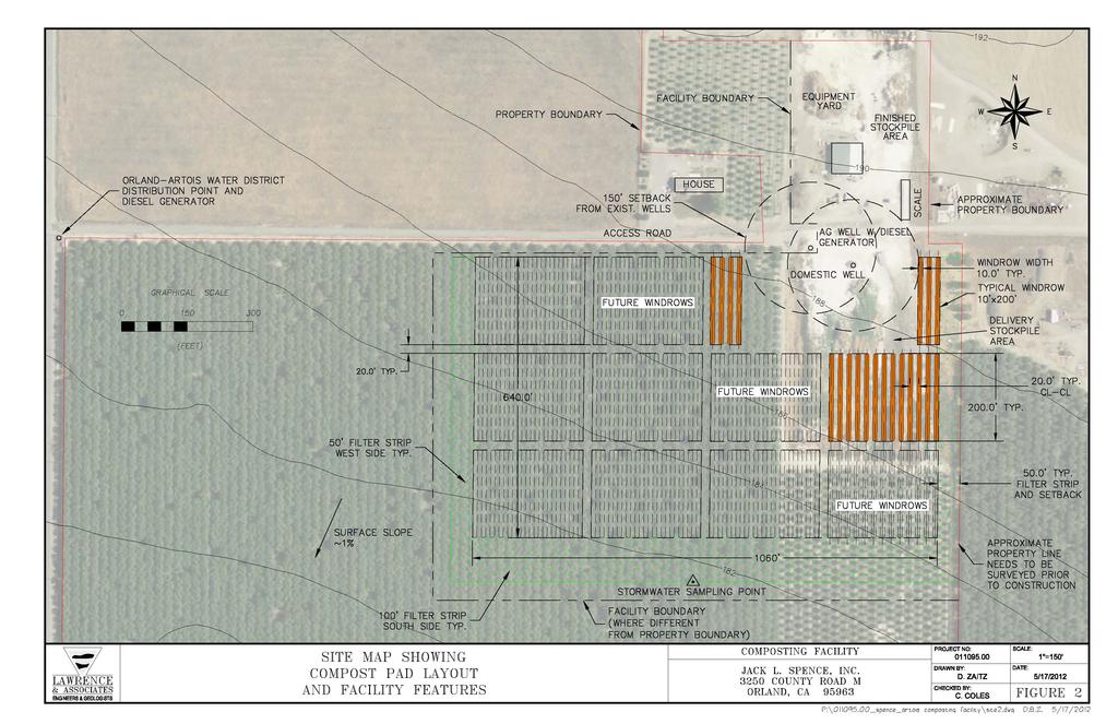
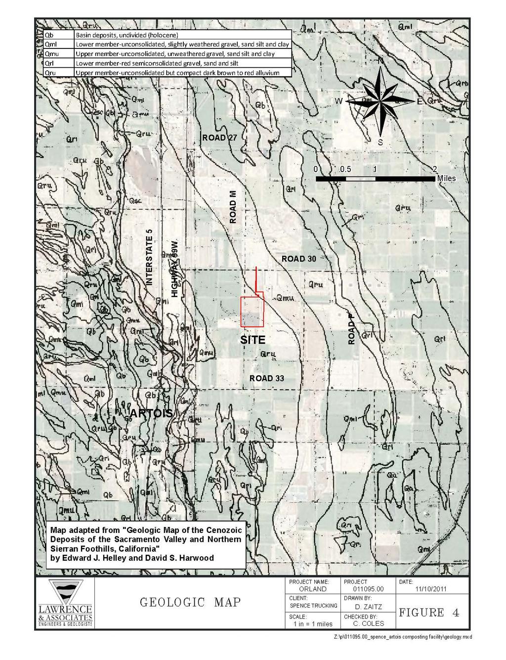
1 FIGURES 1. Site Vicinity Map 2. Site Map Showing Compost Pad Layout and Facility Features 3. Wells Within One Mile of Facility and Groundwater Basin Contour Map 4. Geologic Map 5. Soils Map 6. Zoning Map 7. Winter Compost Storage 8. CNDDB 5-Mile Radius Map


2 UV36 UV Miles Rancho Tehama Reserve Red Bluff John R Trainor Park Gerber-Las Flores Los Molinos UV99 UV 32 Corning UV32 5 Orland Hamilton City UV99 UV32 Bidwell-Sacramento River SP Chico Bidwell Park Magalia Paradise Concow UV162 SITE Durham UV191 UV70 Lake Oroville State Rec Area 5 Willows UV45 Oroville UV70 UV162 Thermalito Biggs Palermo Gridley UV45 UV99 UV70 Live Oak Colusa UV20 Nice Alpine Park Lucerne UV20 Clearlake Oaks UV281 Kelseyville Clearlake UV20 SITE VICINITY MAP Sutter Williams Marysville Tierra BuenaYuba City South Yuba City Linda Olivehurst UV45 UV99 UV16 Arbuckle UV113 PROJECT NAME: PROJECT ARTOIS /11/2011 CLIENT: SPENCE D. ZAITZ CHECKED BY: 1 in = 10 miles C. COLES FIGURE 1 Z:\p\ _spence_artois composting facility\siteloc.mxd
3


4 ,000 1, ,000 4, WALKER CREEK INTERSTATE Feet i= HIGHWAY 99W A! A! A!! A A!!!! A! A! A! A MILE ROAD 30 ROAD M! A! A ! A SITE A! i= ROAD N Legend Well From Field Survey Well Used for Contouring (DWR Data) Well Location from DWR Data Groundwater Gradient Groundwater Contour on Mile Radius Property Boundary Assessor's Parcel Road WELLS WITHIN ONE MILE OF FACILITY AND GROUNDWATER BASIN CONTOUR MAP PROJECT NO: JACK L. SPENCE, INC inch = 2,000 feet P.O. Box Papst Ave. D. ZAITZ Orland, CA CHECKED BY: C. COLES FIGURE 3 Z:\ _spence_artois composting facility\11x17.mxd
5

6 Gp Map Unit Symbol As Czg HgA Hl HmA Me MzrA Pg Rh TcA Tm ZbA Tg Hl Description ROAD M Arbuckle gravelly loam, 0 to 2 percent slopes Arbuckle gravelly sandy loam, 0 to 2 percent slopes Cortina gravelly loam, water table Cortina very gravelly sandy loam Hillgate loam, 0 to 2 percent slopes Hillgate clay loam, 0 to 3 percent slopes Hillgate gravelly loam, 0 to 2 percent slopes Maywood loam, shallow over gravel Myers clay, 0 to 3 percent slopes Plaza silty clay loam Riverwash Tehama loam, 0 to 3 percent slopes Tehama clay loam, 0 to 2 percent slopes Tehama silt loam, 0 to 3 percent slopes Zamora silty clay loam, 0 to 2 percent slopes HmA Pg Tg Hl Tg As HgA AoB W Tm HgA Tm ROAD 30 Tm As SITE TcA Legend SOILS MAP PROJECT NAME: ORLAND CLIENT: SPENCE TRUCKING 1 in = 2,000 feet 0 1,000 2,000 4,000 Feet PROJECT D. ZAITZ CHECKED BY: C. COLES Property Boundary 12/28/2011 FIGURE 5 Z:\p\ _spence_artois composting facility\soilsmap8.5x11.mxd


 023-250-008-9 023-250-010-9 RE-10 (Rural 023-250-009-9 Residential Estate Zone, 8.")
 019-200-025-9 MP (Industrial Park or MP District) 023-230-006-9 023-240-004-9 023-250-007-9 RE-NW (Rural Residential Estate Zone")
 019-200-018-9 023-230-002-0 023-230-003-0 2,000 0 2,000 4,000 Legend Property Boundary RZ (Recreational Zone) 023-230-007-0")
 AP-80 (Agricultural Preserve Zone, 72 acre minimum) AE-80 (Exclusive Agricultural Zone, 72 acre minimum)")
 AT-10 (Agricultural Transitional Zone, 8.5 acre minimum) RE-2 (Rural Residentail Estate Zone, 1.")
 R-1 (Single Family Residential Zone) RM (Multiple Residential Zone) LC (Local Commercial District) SC (Service Commercial Zone) M")
7 P R INTERSTATE HIGHWAY 99W W Walker Creek ROAD M SITE M ZONING MAP ROAD ROAD , ROAD P P Road TPZ (Timberland Preserve Zone) RE-10 (Rural Residential Estate Zone, 8.5 acre minimum) RE-5 (Rural Residential Estate Zone, 4.25 acre minimum) MP (Industrial Park or MP District) RE-NW (Rural Residential Estate Zone - North Willows) CC (Community Commercial Zone) HVC (Highway Visitor and Commercial Zone) PDC (Planned Development Commercial Distrcit) , ,000 4,000 Legend Property Boundary RZ (Recreational Zone) FA (Foothill Agricultural/Forestry Zone, 144 acre minimum) AP-160 (Agricultural Preserve Zone, 144 acre minimum) FS (Farmland Security Zone, 72 acre minimum) AP-80 (Agricultural Preserve Zone, 72 acre minimum) AE-80 (Exclusive Agricultural Zone, 72 acre minimum) AE-40 (Exclusive Agricultural Zone, acre minimum) AE-20 ( Exclusive Agricultural Zone, 17 acre minimum) AT-10 (Agricultural Transitional Zone, 8.5 acre minimum) RE-2 (Rural Residentail Estate Zone, 1.7 acre minimum) S RE-1 (Rural Residential Estate Zone, 40,000 sq. ft. minimum) R-1 (Single Family Residential Zone) RM (Multiple Residential Zone) LC (Local Commercial District) SC (Service Commercial Zone) M (Industrial Zone) AV (Airport Zone) Feet PROJECT NO: JACK L. SPENCE, INC inch = 2,000 feet P.O. Box Papst Ave. D. ZAITZ Orland, CA CHECKED BY: C. COLES FIGURE 6 Z:\ _spence_artois composting facility\11x17c.mxd
8 5 BY 5 ROPE GRID WITH SAND BAG AT EACH NODE GRIFFOLYN TX-1200 LINER, OR EQUIVALENT SAND BAGS COMPOST 2:1 SLOPE 12 to 24 3 ft. Min. STRAW BALE PREPARED PAD CLIENT: JACK L. SPENCE, INC. WINTER COMPOST STORAGE PROJECT: COMPOST FACILITY LAWRENCE & ASSOCIATES 3590 IRON COURT SHASTA LAKE, CALIFORNIA PHONE: (530) FAX: (530) JOB NO.: NTS DEC K. SWANSON FIGURE 7
9 Project Site Swainson's hawk burrowing owl tricolored blackbird vernal pool fairy shrimp CNDDB 5-MILE RADIUS MAP FIGURE 8 Special Status Species Data USGS 7.5' Quadrangle Map: Orland Township 21 North, Range 3 West, MDB&M Project Boundary 5 Mile Radius Buffer 2 Miles Map Produced by Glenn County Planning & Public Works Agency, 2012
Colusa County Almonds
 Morgan Houchin. 3430 Unicorn Road Bakersfield, CA 93308 mobile office efax 526.97 +/- Acres of Colusa County Almonds Cork McIsaac, Broker. Broker License No. 01216717 P.O. Box 1076 West Sacramento, CA
Everett Prune Farm Glenn County, California
 Everett Prune Farm Glenn County, California Proudly Offered By 707 Merchant Street, Suite 100, Vacaville, Ca 95688 (707) 455-4444 Office (707) 455-0455 Fax info@caoutdoorproperties.com www.californiaoutdoorproperties.com
Richfield Prunes, Pistachios & Walnuts
 AG-LAND Investment Brokers 275 Sale Lane Red Bluff, CA 96080 530-529-4400 Fax 530-527-5042 Richfield Prunes, Pistachios & Walnuts 210 +/- acres 3 Parcels Corning, CA - Tehama County jsubject AG-LAND
268 Acres m/l, Iowa County, IA. Offered in 2 Remaining Parcels. Parcel Ac. m/l Parcel 2-81 Ac. m/l Parcel 3-45 Ac. m/l - SOLD!
 LAND FOR SALE 268 Acres m/l, Iowa County, IA Offered in 2 Remaining Parcels Parcel 1-187 Ac. m/l Parcel 2-81 Ac. m/l Parcel 3-45 Ac. m/l - SOLD! Golden Grain Enterprises Good Iowa County Farms Located
Sacramento River Farmland Anderson, California
 AG-LAND INVESTMENT BROKERS 275 Sale Lane / P. O. Box 896 Red Bluff, CA 96080 530.529.4400 office / 530.527.5042 fax Sacramento River Farmland Anderson, California Property: 43 +/- acres of farmland with
RaC. RaD GlG. GlF. RaD GlE. CeA. RaE. RcD. GoF. GoF SkC. SkD. CfA. AdA. GoF. GoF. GoF. RcD. GgD. GoF. RaE GlE. RaE DbF. GoF. DbE. RaC.
 526300 527400 528500 529600 530700 531800 532900 534000 535100 4240200 4241300 4242400 4243500 4244600 4245700 ADRIAN DR FAIRWAY DR STATE FARM DR DOLORES DR HUDIS ST SANTA ALICIA DR Cotati PAGE ST ALTA
California (Oroville) Vendor Services Directory
 Vendor Services Directory") California (Oroville) Vendor Services Directory July 2009 Table of Contents Air Conditioning & Heating Appliance Repair Carpet Cleaning Electric Services Equipment Rental Fire Protection & Safety Glass
California (Oroville) Vendor Services Directory July 2009 Table of Contents Air Conditioning & Heating Appliance Repair Carpet Cleaning Electric Services Equipment Rental Fire Protection & Safety Glass
In November and December, SACOG staff conducted the following Blueprint Implementation land use activities:
 SACOG Board of Directors Item #18-1-16 Receive & File January 11, 2018 Blueprint Implementation Activities The purpose of this item is to regularly inform the Board of SACOG land use related activities
Auction Location Eagles Club 316 S. 2 nd Street, Aberdeen, SD
 Auction Location Eagles Club 316 S. 2 nd Street, Aberdeen, SD Welcome We would like to invite and welcome you to our public auction! This is an excellent opportunity to add Brown County cropland to your
Antioch Habitat Conservation Plan/Natural Community Conservation Plan
 Antioch Habitat Conservation Plan/Natural Community Conservation Plan Science Advisor Workshop February 8, 2018 Kathryn Gaffney Project Manager Matt Ricketts Lead Biologist 1 PRESENTATION OUTLINE Background
III. PROJECT DESCRIPTION
 III. PROJECT DESCRIPTION A. PROJECT LOCATION Regional Setting The project site is located in the southeast quadrant of the City of Chico in Butte County, California and is comprised of four parcels totaling
Vineyard Variability Due To Differences in Soil. Ann Tan UC Davis
 Vineyard Variability Due To Differences in Soil Ann Tan UC Davis Background We know that soils are important, but how much do they affect grape productivity and fruit quality? Some studies suggest a role
W.H. Bonner Associates
 15619 Ogram Avenu Gardena, CA 90249-444 W.H. Bonner Associates Archaeofaunal Studies Archaeological Surveys Historical & Genealogical Research (310) 675-274 E-mail: whbonner@aol.com April 21, 2014 Wendy
80 ACRES M/L BOONE COUNTY, IOWA LISTING # Pilot Mound, Iowa. I Avenue. 130th Street. Co Hwy P th Street
 Co Hwy P70 I Avenue 80 ACRES M/L BOONE COUNTY, IOWA CAPTION Pilot Mound, 130th Street 130th Street LISTING #12320 New Listing Price! $800,000 DESCRIPTION: High Quality Farm in Strong Farming Area and potential
Wisconsin Contractors Institute Continuing Education
 Wisconsin Contractors Institute Continuing Education Erosion & Sediment Control Course # 12775 2 hours Wisconsin Contractors Institute N27 W23953 Paul Road, Suite 203 Pewaukee, WI 53072 Website: www.wicontractorsinstitute.com
FOR SALE ± ACRES VALENTINES, VIRGINIA Price: $150,000
 LATITUDE & LONGITUDE 36.566924, -77.764781 Features STRONG RECREATIONAL INVESTMENT opportunity located south of Triplet with access from VSR 600 (Triplet Rd.) to the north. TRACT HAS BEEN RECENTLY CUTOVER
Final Initial Study. Chalice Unitarian Universalist Congregation Conditional Use Permit
 5 Final Initial Study Chalice Unitarian Universalist Congregation Conditional Use Permit Appendix B Chalice Unitarian Universalist Congregation Cultural Resources Memorandum TRC 9685 Research Drive Irvine,
Notice of Preparation and Notice of Public Scoping Meeting. At Dublin Project
 Notice of Preparation and Notice of Public Scoping Meeting Date January 17, 2018 To Project Title Project Application Number Project Location Project Applicant Contact For questions or submitting comments.
BLOOMSBURY BOROUGH. Regional Master Plan Overlay Zone Designation. 1 inch = 0.28 miles. Zone. Sub-Zone FRANKLIN TOWNSHIP GREENWICH TOWNSHIP
 Regional Master Plan Overlay Zone Designation Zone Protection Lakes Greater Than 10 acres Conservation Existing Community Sub-Zone Existing Community Environmentally Constrained Conservation Environmentally
Demoss Farm & Home 118 Acres, M/L W. 209th Ave. Pattonsburg, Mo 64670
 118 Acres, M/L 39436 W. 209th Ave. Pattonsburg, Mo 64670 PRICE: $400,000.00 LAND USE: FSA shows approx. 118.32 farmland acres, ml, of which there were 36.47 acres of effective cropland with the remainder
NOTICE OF PREPARATION
 NOTICE OF PREPARATION DATE: January 6, 2016 TO: LEAD AGENCY: Responsible Agencies, Organizations, and Interested Parties Contact: Tyler Barrington, Principal Planner Planning Department Community Development
PROPOSED DRAINAGE PATTERNS
 1121 1118.50 Basin Floor 1120 1119 0 N 100 200 PROPOSED DRAINAGE PATTERNS Deroiser Drive Riverwood Drive County 260 0 100 200 Project Name: Riverwood Drive LITTLE FALLS TOWNHOMES Project Location: LITTLE
NAPA COUNTY LAND USE PLAN
 NAPA COUNTY LAND USE PLAN 2008-2030 * LEGEND URBANIZED OR NON-AGRICULTURAL Cities Urban Residential Rural Residential Industrial Public-Institutional Study Area OPEN SPACE * * Agriculture, Watershed &
FOR SALE Temperance Ranch
 Temperance Ave. FOR SALE Temperance Ranch E. American Ave. 162.49± Acres Fresno County, California Exclusively Presented By: Pearson Realty New 13,000 S.F. aluminum solar panel pole barn Four pumps and
Horner-McLaughlin Woods: Soil Types
 Horner-McLaughlin Woods: Soil Types Not present at HMW Adrian Muck Conover Loam 0-4% Slopes Houghton Muck Miami Loam 2-6% Slopes Miami Loam 6-12% Slopes Miami Loam 12-18% Slopes t 0 0.125 0.25 Miles Mary
Farmland For Sale 3 Tracts /- acres Webster County, Iowa Section 31, T88N, R30W & Section 33, T88N, R29W
 Farmland For Sale 3 Tracts 316.02 +/- acres Webster County, Section 31, T88N, R30W & Section 33, T88N, R29W Contact Martin today! 309-242-7299 mthornton@hbtbank.com Martin G. Thornton, Broker 200 W. College
365.8 Acres +/- Brown County, KS February 28, 2019 at 10:30 am Community Building, 511 West Front Street, Fairview, KS
 Farmland Auction February 28, 2019 at 10:30 am Community Building, 511 West Front Street, Fairview, KS This excellent Brown County farm is just North of Fairview, KS and it will be selling in 3 tracts
Deuel County Dryland
 Deuel County Dryland Two parcels of dryland farm ground near Lewellen, NE Property Highlights List Price $852,474 $786,877 Location 12-15 miles south of Lewellen, Ne or the same distance from Big Springs,
HILCORP ALASKA, LLC HAPPY VALLEY MIDDLE NATURAL GAS EXPLORATION PROJECT DEEP CREEK UNIT BOUNDARY PROPOSED ACCESS ROAD T02S T03S R14W
 , LLC STERLING HWY. M.P. 142.8 28 33 TIM AVE. DEEP CREEK UNIT BOUNDARY 27 26 25 TIM AVE. CULVERT REPLACEMENT PROPOSED ACCESS ROAD 34 35 36 T2S T3S 31 NINILCHIK, ALASKA 5 4 3 2 BEGIN ROAD CONSTRUCTION 1
Natomas Vision Plan and PLNP
 Natomas Vision Plan 20030171 and PLNP2014-00172 Department of Community Development Planning and Environmental Review Leighann Moffitt Sub-Agenda 1. Staff Presentation Leighann Moffitt, County Planning
YOLO COUNTY INTEGRATED REGIONAL WATER MANAGEMENT PLAN
 YOLO COUNTY INTEGRATED REGIONAL WATER MANAGEMENT PLAN CHAPTER 1 CHAPTER 2 CHAPTER 3 CHAPTER 4 CHAPTER 5 CHAPTER 6 APPENDIX A OVERVIEW OF IRWMP EFFORT GEOLOGY, HYDROGEOLOGY, AND GROUNDWATER IN YOLO COUNTY
+/- 60 AC LAND FOR SALE HARLEY ROAD, ELBURN, IL 60119
 Land For Sale OFFERING SUMMARY Sale Price: $660,000 Price / Acre: $11,000 PROPERTY OVERVIEW +/- 60 acres available for purchase on the west side of Harley Road, South of Rt. 38. This site has Harley Road
ARTICLE IV: DEVELOPMENT STANDARDS 404 MASTER PLANNING
 IV 13 404 MASTER PLANNING Master Planning through the Site Analysis (Master Planning Site Analysis) or Planned Development (Master Planning Planned Development) is provided to encourage development which
Ranson,West Virginia LAND DEVELOPMENT PLAN AND PLAT APPLICATION MARCH 12, 2012
 C L A Y H I L L F A R M Ranson,West Virginia LAND DEVELOPMENT PLAN AND PLAT APPLICATION MARCH, OWNER / APPLICANT Strider, LLC Brandywine Drive Charlottesville, VA APPLICATION PREPARATION PlaceMakers, LLC
Area 3 Envirothon Soils Questions Key
 Area 3 Envirothon Soils Questions Key 1. Soil aeration is the exchange of air in soil with air from the atmosphere. When a soil is well aerated, the air within the soil is very similar to the atmosphere
Project Narrative For Fruita RV Resort Conditional Use Permit
 Project Narrative For Fruita RV Resort Conditional Use Permit Date: November 18, 2016 Prepared by: Robert W. Jones, II, P.E. Vortex Engineering & Architecture, Inc. 2394 Patterson Rd., Ste. 201 Grand Junction,
FARMLAND AUCTION. FSA INFORMATION: Farmland: acres Cropland: acres Tillable: acres
 FARMLAND AUCTION January 22, 2019 at 10:30 am Keep an eye on BarnesRealty.com for possible blizzard date of 1/24/2019 Fisher Community Center, 201 E. Iowa St. Hiawatha, KS 66434 Here is a very productive
COMMUNITY DEVELOPMENT SERVICES PLANNING AND BUILDING DEPARTMENT PLACERVILLE OFFICE:
 COMMUNITY DEVELOPMENT SERVICES PLANNING AND BUILDING DEPARTMENT http://www.edcgov.us/devservices/ PLACERVILLE OFFICE: LAKE TAHOE OFFICE: 2850 Fair Lane Court, Placerville, CA 95667 924 B Emerald Bay Rd.
7.0 SOCIAL, ECONOMIC, AND ENVIRONMENTAL ISSUES
 7.0 SOCIAL, ECONOMIC, AND ENVIRONMENTAL ISSUES The following list of social, economic, and environmental issues have been identified based on a preliminary inventory of resources in the project area, an
173 ACRES - RILEY COUNTY, KS
 Buyers, Sellers & Land Connected PRICE: $690,000 ACRES: 173 COUNTY: RILEY STATE: KANSAS First Class Hunting with Outstanding Income Potential If you have ever dreamed of owning your very own piece of first
TP73 4PTP101 TP45 TP9 TP74 TP46 TP47 TP115 TP48 TP32 TP5 TP31 TP22 TP49 V58 TP57 4F TP50 TP51 3PD 3PD TP80 TP28 TP55
 Figure 2.1-3 - Capability Assessment Map Part of Lots 18 and 19, Concession 3 Township of Russell sified unclas TP72 TP90 TP624P V18 3D TP35 TP73 4PTP101 3D TP45 TP9 TP74 TP89 TP117 V61 V34 TP19 TP20 TP100
SOIL SEPARATES. Soil Evaluator Day 2, Presentation 3-3/27/2018. Soil Texture, Page 1 TITLE 5 SOIL EVALUATOR CERTIFICATION TRAINING SOIL TEXTURE
 Soil Evaluator Day 2, Presentation 3-3/27/18 TITLE 5 SOIL EVALUATOR CERTIFICATION TRAINING SOIL TEXTURE Prepared for: Commonwealth of Massachusetts Department of Environmental Protection By L.A. Spokas,
Urban Planning and Land Use
 Urban Planning and Land Use 701 North 7 th Street, Room 423 Phone: (913) 573-5750 Kansas City, Kansas 66101 Fax: (913) 573-5796 Email: planninginfo@wycokck.org www.wycokck.org/planning To: From: City Planning
WALKER FEEDLOT Total taxable acres, part fenced. 4 homes & multiple nice/modern outbldgs hd feedyard with sprinklers a-shkd-0002
 ABILENE WALKER FEEDLOT 38.7 Total taxable acres, part fenced 4 homes & multiple nice/modern outbldgs 3500 hd feedyard with sprinklers a-shkd-0002 Center pivot irrigation from lagoons 999 hd feedlot A-SHDK-B020
Soils and their Relationship with Agriculture
 Soils and their Relationship with Agriculture Presentation created by Thomas Gallagher Modified by Hank Bignell Capital Area Agriculture and Horticulture Program Cornell University Cooperative Extension
Walnut Hedgerow Trial on Marginal Soils. Bill Krueger, John Edstrom and Wilbur Reil
 Walnut Hedgerow Trial on Marginal Soils Bill Krueger, John Edstrom and Wilbur Reil Objectives Evaluate potential for hedgerow English walnuts on marginal soil Compare performance of NCB and Paradox Test
Figure 1. Project Vicinity and Context
 SPK-2003-00670 PN: Figure 1. Vicinity Map Figure 1. Project Vicinity and Context COUNTRY ACRES LN SYMPHONY AVE LOCUST RD LN Y LEW R H O A M RT O N LN PV 19 Phase 1 Development LN PV 19 Phase 1 Backbone
JOINT PUBLIC NOTICE. 26 June United States Army Corps of Engineers State of Louisiana
 JOINT PUBLIC NOTICE 26 June 2017 United States Army Corps of Engineers State of Louisiana New Orleans District Department of Environmental Quality Regulatory Branch Office of Environmental Services 7400
Low Flow Rates Low Filtration Sandy Soils Medium Flow Rates Medium Filtration Clayey Soils [1] High Flow Rates High Filtration Polluted Soils
![Low Flow Rates Low Filtration Sandy Soils Medium Flow Rates Medium Filtration Clayey Soils [1] High Flow Rates High Filtration Polluted Soils](/thumbs/82/86978219.jpg "Low Flow Rates Low Filtration Sandy Soils Medium Flow Rates Medium Filtration Clayey Soils [1] High Flow Rates High Filtration Polluted Soils") Filter Ponds DE-WATERING SEDIMENT CONTROL TECHNIQUE Low Flow Rates Low Filtration Sandy Soils Medium Flow Rates Medium Filtration Clayey Soils [1] High Flow Rates High Filtration Polluted Soils [1] Capture
Filter Ponds DE-WATERING SEDIMENT CONTROL TECHNIQUE Low Flow Rates Low Filtration Sandy Soils Medium Flow Rates Medium Filtration Clayey Soils [1] High Flow Rates High Filtration Polluted Soils [1] Capture
September 20, 2016 Soils Investigation for Agricultural Designation Windemere Place, Missoula County, Montana
 September 20, 201 Soils Investigation for Agricultural Designation Windemere Place, Missoula County, Montana The purpose of this report is to compare on-site soils of the proposed subdivision with the
Appendix I-A3 DENAIR COMMUNITY PLAN
 Appendix I-A3 DENAIR COMMUNITY PLAN Adopted by the Stanislaus County Board of Supervisors DECEMBER 15, 1998* *A technical update removing reference to the former Stanislaus County Redevelopment Agency
AN ARCHAEOLOGICAL SURVEY FOR THE RICHARDS, TEXAS FARM-TO-MARKET ROAD 149 FIBER OPTIC CABLE PROJECT IN MONTGOMERY COUNTY, TEXAS
 AN ARCHAEOLOGICAL SURVEY FOR THE RICHARDS, TEXAS FARM-TO-MARKET ROAD 149 FIBER OPTIC CABLE PROJECT IN MONTGOMERY COUNTY, TEXAS Antiquities Permit 6097 By William E. Moore Brazos Valley Research Associates
2011 Wisconsin Envirothon Soils and Land Use Exam
 2011 Wisconsin Envirothon Soils and Land Use Exam USE THE OCONTO COUNTY SOIL SURVEY TO ANSWER QUESTIONS 1-4 The Pensaukee River Wetland Complex is a mixture of state (Pensaukee Wildlife Area) and privately
Access. Proposed Location (Existing Buidings/Site) 1:18,056. June 6, Subdivisions. Parcels. Sections
 1:18,056. June 6, Subdivisions. Parcels. Sections") Access Proposed Location (Existing Buidings/Site) June 6, 2018 Subdivisions Parcels DISCLAIMER: This map is not intended for conveyances, nor is it a legal survey. The information is presented on a best-efforts
Access Proposed Location (Existing Buidings/Site) June 6, 2018 Subdivisions Parcels DISCLAIMER: This map is not intended for conveyances, nor is it a legal survey. The information is presented on a best-efforts
Northeast Quadrant Plan
 Northeast Quadrant Plan Northeast Quadrant Distinctive Features Land Use The Northeast Quadrant includes all the area within the planning area that is east of Interstate 5 and to the north of State Route
Bull Canyon Ranch 2750 BULL CANYON ROAD, SANTA MARIA, CALIFORNIA PRESENTED FOR SALE BY: Rincon corporation
 Bull Canyon Ranch 2750 BULL CANYON ROAD, SANTA MARIA, CALIFORNIA PRESENTED FOR SALE BY: Rincon corporation THE FULL SERVICE REAL ESTATE COMPANY FOR THE AGRICULTURAL COMMUNITY Bull canyon ranch, santa maria
Aerial Map. map center: 38 0' 55.53, ' S-4E Franklin County Illinois
 Aerial Map map center: 38 0' 55.53, -88 42' 58.78 0ft 594ft 1188ft 11/24/2016 Field borders provided by Farm Service Agency as of 5/21/2008. Soils data provided by University of at Champaign-Urbana. Topography
SITE CONTEXT, CONCORD, MA. Concord. Acton LEENA CHO / GSD 1211 / 2 HECTARE MAPPING PROJECT /
 SITE CONTEXT, CONCORD, MA This context ap shows the boundary of our studio site in West Concord, Massachusetts. My detail area is located within the state-owned property of Departent of Correction, just
2.0 Hi s t o r y & Existing Co n d i t i o n s
 2.0 Hi s t o r y & Existing Co n d i t i o n s 2.1 Plan Area History The Lincoln East Specific Plan (Specific Plan) area is a significant part of the history of Sutter County. A 48,000 acre land grant
LAND FOR SALE 82 ACRES M/L CEDAR COUNTY, IOWA LISTING # DOUGLAS R. YEGGE C: O:
 LAND FOR SALE LISTING #13968 82 ACRES M/L CEDAR COUNTY, IOWA DOUGLAS R. YEGGE C: 563-320-9900 O: 563-659-8185 Doug@PeoplesCompany.com ALAN MCNEIL C: 563-321-1125 O: 563-659-8185 Alan@PeoplesCompany.com
2 Older farm homes on the land
 2 Older farm homes on the land LAND RANCHES EXCHANGES This ranch consists of 70 +/_ acres of level farmland. Prime 13700 POWERHOUSE RD POTTER VALLEY agricultural land at an attractive price. This property
Gadsden County Planning Commission Agenda Request
 Date of Meeting: November 16, 2017 To: From: Through: Subject: Gadsden County Planning Commission Agenda Request Honorable Chairperson and Members of the Board Jill A. Jeglie, AICP, Senior Planner Clyde
Land Use LAND USE. Major Findings. Town of Windsor General Plan Update
 Land Use Town of Windsor General Plan Update LAND USE This chapter reviews the present (2014) context for land use planning in the Town of Windsor. It provides a comprehensive overview of how land resources
Appendix Q. Baseline Biology Report
 Appendix Q Baseline Biology Report A u g u s t 2 0 1 4 (DRECP) Baseline Biology Report Prepared for: California Energy Commission 1516 Ninth Street Sacramento, California 95814 Under Contract to: Aspen
FOR SALE. Reedley Apricot Ranch ± Acres Fresno County, California. CA BRE #
 FOR SALE Reedley Apricot Ranch 126.89± Acres Fresno County, California Exclusively Presented By: Pearson Realty Majority of soils are Grade 1 Seven apricot varieties Consolidated Irrigation District CALIFORNIA
EACCS Goal: provide guidelines for mitigation practices and overall conservation in east Alameda County
 EAST ALAMEDA COUNTY CONSERVATION STRATEGY: A BLUEPRINT FOR ACTION Community Meeting June 11, 2009 Agenda Welcome and Introductions Project Update o Introduction o Progress to Date o Next Steps Perspectives
FARMLAND FOR SALE ± Acres 5 Tracts
 Now is your chance to acquire productive farmland in Greene County, Illinois. Greene County, IL FARMLAND FOR SALE 756.08± Acres 5 Tracts Highly productive riverbottom farms Heavily improved with tiling
Property Description History Regional Orientation Local Context Existing Assets Analysis Of Developable Areas...
 Appendix: Site Background and Analysis Property Description.... 48 History.... 48 Regional Orientation... 49 Local Context... 52 Existing Assets... 53 Analysis Of Developable Areas... 64 Aggregate Resources....
Table IX-1 LAND USES IN WASHINGTON COUNTY: 2006
 #128550 v1 - WASH CO CP TBL I-1 2006 LU NMA/RLR 12/21/07 Table I-1 LAND USES IN WASHINGTON COUNTY: 2006 Note: This table, and the accompanying map, is more general than the land use inventory conducted
 108 40' 29'' W Soil Map Mesa County Area, Colorado 108 36' 55'' W 39 10' 11'' N 39 6' 31'' N 4331700 4332500 4333300 4334100 4334900 4335700 4336500 4337300 4338100 701100 701900 702700 703500 704300 705100
Natomas Joint Vision Open Space Plan
 Natomas Joint Vision Open Space Plan First Workshop series The City of Sacramento The County of Sacramento LAFCo ERA Economic Research Associates EIP Associates a Division of PBS & J Natomas Joint Vision
AVA I L A B L E L AT H R O P G AT E WAY B U S I N ESS PA R K
 Proposed Master Plan - Aerial Site Plan Property Specifications: Site Size: Zoning: Sewer: Water: Storm: Gas & Electric: Property Summary: 173.60± Acres, consisting of eleven (11) Parcels LI, Light Industrial,
Example Stormwater Control Plan For a Residential Subdivision Project. Whispering Pines Lane Anytown, USA. February 21, 2018
 Example Stormwater Control Plan For a Residential Subdivision Project Whispering Pines Lane Anytown, USA February 21, 2018 XYZ Corporation Jane Jones, 925-555-1212 This example prepared by Dan Cloak Environmental
Chapter 1 Vision Statement & Goals
 Chapter 1 Section 1.1 Section 1.2 Section 1.3 Section 1.4 Section 1.5 Introduction Vision Statement Visioning Exercise Prioritization of Land Use Issues Goals of the Comprehensive Plan CHAPTER 1 SECTION
PLNPCM Carl s Jr. Commercial Parking Lot at Redwood Road and 1700 South
 Staff Report PLANNING DIVISION COMMUNITY & NEIGHBORHOODS To: Salt Lake City Planning Commission From: Casey Stewart; 801-535-6260 Date: November 4, 2016 Re: PLNPCM2015-00874 Carl s Jr. Commercial Parking
City of Fontana Notice of Preparation and Notice of Public Scoping Meeting Fontana North Walmart Project
 Notice of Preparation and Notice of Public Scoping Meeting Fontana North Walmart Project Date: Monday, February 22, 2016 To: From: Subject: Public Agencies and Interested Parties Orlando Hernandez, Senior
EXHIBIT 6-1 TOWN OF AURORA COMMUNITY FACILITIES. Aurora Municipal Building. Cell Tower (U.S. Cellular) Cell Tower (AAT Communication)
 Cell Tower (AAT Communication)") 3ST AVE 3ND AVE EXHIBIT 6- COMMUNITY FACILITIES Aurora Municipal Building Cell Tower (U.S. Cellular) Cell Tower (AAT Communication) 8 9 0 Cell Tower (Alltel Corporation) Waste Collection Site Aurora Center
3ST AVE 3ND AVE EXHIBIT 6- COMMUNITY FACILITIES Aurora Municipal Building Cell Tower (U.S. Cellular) Cell Tower (AAT Communication) 8 9 0 Cell Tower (Alltel Corporation) Waste Collection Site Aurora Center
Northeast Perkins County Pivots
 Northeast Perkins County Pivots 315.9± acres of center pivot irrigated farmland Southeast of Paxton, NE Email: Jordan@lashleyland.com Property Highlights List Price $1,550,000 Location Southeast of Paxton,
EXHIBIT A LAND USE EQUIVALENCY MATRIX
 EXHIBIT A LAND USE EQUIVALENCY MATRIX Trade To Single Family Single Family Multi- Shopping Medical Nursing Trade From Detached (DU's) Attached (DU's) Family (DU's) Center (KSF) ALF (Beds) Hotel (Rooms)
SW CORNER ROUTE 38 AND HARLEY ROAD SW CORNER ROUTE 38 & HARLEY ROAD, KANE COUNTY, IL 60119
 REDUCED: Land For Sale SW CORNER ROUTE 38 AND HARLEY ROAD REDUCED: 124 AC ON IL ROUTE 38 OFFERING SUMMARY Sale Price: $1,643,000 Price / Acre: $13,250/AC PROPERTY OVERVIEW This 124 AC parcel has approximately
NOTICE OF PREPARATION
 Date: June 30, 2017 CITY OF CITRUS HEIGHTS COMMUNITY & ECONOMIC DEVELOPMENT DEPARTMENT, PLANNING DIVISION 6360 Fountain Square Drive, Citrus Heights, CA 95621 (916) 727-4740 NOTICE OF PREPARATION To: Subject:
FOR SALE ± Acres Fresno County, California. CA BRE # Exclusively Presented By: Pearson Realty
 FOR SALE Orange Cove Citrus Ranch with Custom Home 127.33± Acres Fresno County, California Exclusively Presented By: Pearson Realty Variety of Citrus Plantings Frost Protection District and Well Water
Land for Sale. Baker County, Georgia. $4,960,000 1,984 Acres $2,500 per Acre
 Land for Sale Baker County, Georgia $4,960,000 1,984 Acres $2,500 per Acre 2 Contents Property Fact Sheet... 3 Regional Map... 4 Local Map... 5 Aerial Map... 6 Major Soil Types Map... 7 Soil Classification
CITY OF ROHNERT PARK CITY COUNCIL AGENDA REPORT
 Mission Statement We Care for Our Residents by Working Together to Build a Better Community for Today and Tomorrow. CITY OF ROHNERT PARK CITY COUNCIL AGENDA REPORT ITEM NO. 5 Meeting Date: July 23, 2013
Example Stormwater Control Plan For a Residential Subdivision Project. Whispering Pines Lane Anytown, USA. February 21, 2018
 Example Stormwater Control Plan For a Residential Subdivision Project Whispering Pines Lane Anytown, USA February 21, 2018 XYZ Corporation Jane Jones, 925-555-1212 This example prepared by Dan Cloak Environmental
Landfill Closure, Intermediate Cover & Post-Closure Care. Municipal League Meeting
 Landfill Closure, Intermediate Cover & Post-Closure Care Municipal League Meeting 9-7-17 Gated and Closed Landfill Gated means no longer accepting waste. Closed means gated and final cover has been installed
3 LAND USE AND COMMUNITY CHARACTER ELEMENT
 3 LAND USE AND COMMUNITY CHARACTER ELEMENT Countryside Community Church in Esparto Source: April Farnham-Morrison This element seeks to preserve and foster the rural character of the County. The County
Jackson Highway Master Plans
 Jackson Highway Master Plans West Jackson Highway Master Plan (PLNP2008-00240) Jackson Township Specific Plan (PLNP2011-00095) NewBridge Specific Plan (PLNP2010-00081) Mather South Community Master Plan
WILLISTON CROSSING. Williams County, North Dakota MAJOR COMPREHENSIVE PLAN AMENDMENT PRESENTATION 01/27/2015
 WILLISTON CROSSING Williams County, North Dakota MAJOR COMPREHENSIVE PLAN AMENDMENT PRESENTATION 01/27/2015 Williston Crossing, located in northwest North Dakota, is an exciting mixed use development planned
Sustainable Storm Water Management
 Incorporating Water Management into the Community Planning Process August 16, 2012 Sustainable Storm Water Management Samantha Brown Environmental Engineer SD1 SD1 s Service Area CVG Airport SD1 Service
Information for File #MVP DAS
 Information for File #MVP201702209DAS Applicant: HyVee, Inc. Corps Contact: David Studenski Address: 1114 South Oak Street, La Crescent, Minnesota 559471560 EMail: david.a.studenski@usace.army.mil Phone:
DO YOU KNOW YOUR SOILS? (Rev. 10/11)
") DO YOU KNOW YOUR SOILS? (Rev. 10/11) Circle all the correct answers. 1. What is the layer normally present on the surface of the soil in cropped fields? a. O c. Ap e. B g. R b. A d. E f. C 2. Available
DO YOU KNOW YOUR SOILS? (Rev. 10/11) Circle all the correct answers. 1. What is the layer normally present on the surface of the soil in cropped fields? a. O c. Ap e. B g. R b. A d. E f. C 2. Available
Preliminary Soil Survey at N Fifikh Site
 Feasibility Study on Water Resources Development in Rural Area in the Kingdom of Morocco Final Report Volume VII Data Book Data Book SO Soil Survey SO2 Preliminary Soil Survey at N Fifikh Site Preliminary
Farmland Classification Centre County, Pennsylvania (Student Farm Site) Web Soil Survey National Cooperative Soil Survey
 Web Soil Survey National Cooperative Soil Survey") 256300 256600 256900 257200 257500 257800 258100 77 51' 20'' W 77 53' 26'' W Farmland Classification Centre County, Pennsylvania 258400 258700 259000 40 49' 4'' N 4520600 4520900 4520900 4521200 4521200
256300 256600 256900 257200 257500 257800 258100 77 51' 20'' W 77 53' 26'' W Farmland Classification Centre County, Pennsylvania 258400 258700 259000 40 49' 4'' N 4520600 4520900 4520900 4521200 4521200
280 ACRES - HOWELL COUNTY, MO
 PRICE: $434,700 ACRES: 280 COUNTY: HOWELL STATE: MISSOURI For more information contact: KYLE ORF, Land Agent 417.988.3333 KyleOrf@MidwestLandGroup.com MidwestLandGroup.com 100 280ACRES ACRES- -COUNTY,
Butte County Recycling Newsletter
 Page 1 of 5 Butte County Recycling Newsletter "News you can reuse" Butte County Recycling Newsletter Fall/Winter 2015 Edition News you can Reuse - Fall Foliage Edition Items of Interest: Backyard Composting
AN ARCHAEOLOGICAL SURVEY FOR THE NAVIDAD RESOURCES, LLC FERGUSON STATE PRISON FARM UNIT PROJECT IN MADISON COUNTY, TEXAS
 AN ARCHAEOLOGICAL SURVEY FOR THE NAVIDAD RESOURCES, LLC FERGUSON STATE PRISON FARM UNIT PROJECT IN MADISON COUNTY, TEXAS Antiquities Permit 5714 By William E. Moore Brazos Valley Research Associates Contract
CHAPTER 2 SUMMARY 1. PROJECT SUMMARY DATA
 CHAPTER 2 SUMMARY This is an Initial Study format used to determine, pursuant to CEQA Guidelines Section 15177, whether a project 1) is within the scope of a Master EIR (MEIR), 2) may result in additional
Notice of Preparation of an Environmental Impact Report and Scoping Meeting for the Canyon Lane Roadway Improvements Development Project
 of an Environmental Impact Report and Scoping Meeting for the As the Lead Agency, the County of San Mateo (County) will prepare an Environmental Impact Report (EIR) for the (project), and would like your
Development. Within of 25% or greater. ridges anticipated that the. foundations. and walk out. Page 1 of 4
 Ridge Estates May 11, 2016 LAND SUITABILITY ANALYSIS REPORT 1. INTRODUCTION This report is provided in accordance with the submittal requirements of the Planned Development Plan (PPD). The report accompanies