CITY OF ROHNERT PARK CITY COUNCIL AGENDA REPORT
|
|
|
- Griselda Lawson
- 6 years ago
- Views:
Transcription

1 Mission Statement We Care for Our Residents by Working Together to Build a Better Community for Today and Tomorrow. CITY OF ROHNERT PARK CITY COUNCIL AGENDA REPORT ITEM NO. 5 Meeting Date: July 23, 2013 Department: Development Services Submitted By: Marilyn Ponton, Development Services Manager Prepared By: Marilyn Ponton, Development Services Manager Agenda Title: Review of the Preliminary Land Use Plan for the University District Specific Plan Amendment PL SP RECOMMENDED ACTION: Staff recommends City Council take the following actions: 1) Review the Preliminary Land Use Plan for the University District Specific Plan Amendment and provide any comments to the staff and applicant. BACKGROUND: The Zoning Code requires that a preliminary plan be reviewed at a public hearing by the Planning Commission and City Council to receive public input when considering specific plans. The Planning Commission conducted a review of the Preliminary Land Use Plan at its June 27, 2013 hearing. The comments received from that hearing are summarized below, in the Planning Commission Review of Preliminary Land Use Plan section of this report. The University District Specific Plan ( Specific Plan ) is one of five specific plan areas designated in the City s General Plan for future development. The Specific Plan includes approximately 300 acres of lands owned by five property owners (University District LLC, Vast Oak Properties, Cotati-Rohnert Park Unified School District, Gee, and Linden) in the City of Rohnert Park. In 2006, the University District Specific Plan document was approved and associated General Plan amendments were adopted and implemented. The adopted Specific Plan addresses the land use and development standards for the Specific Plan area, which was annexed to the City in Attachment A (Figure General Plan Diagram of the City s General Plan) shows the current land use categories within the City, including those approved for the Specific Plan area. Table 1 provides a summary of the gross acreage and building area for each of the land use categories currently shown in the General Plan within the Specific Plan area. 1
2 ITEM NO. 5 Table 1 General Plan Land Use - University District Specific Plan Area Gross Acreage 1 Building Area (1,000sf) Minimum- Maximum Rural Estate Residential Low Density Residential Medium Density Residential High Density Residential Mixed Use Maximum of 175 Parks Plaza Linear Park Open Space Copeland Creek (north side) Crane Creek (south side) Hinebaugh Creek Petaluma Hill Road Buffer Total 300 Maximum of Excludes acreage for the Rohnert Park Expressway between the easterly City limits and Petaluma Hill Road, and Keiser Avenue. The approved Specific Plan allowed a maximum of 1,645 residential units (excluding second residential units). The dwelling units are allocated are shown in Table 2. Table 2 University District Specific Plan Area Units Designation Number of Units Rural Estate Residential 26 Low Density Residential 320 Medium Density Residential 537 High Density Residential 612 Mixed Use 150 Total 1,645 Specific Plan Amendment Proposal The proposed 2013 Draft Specific Plan Land Use Plan Amendment (Attachment B) includes the mix, intensity, and general location of development types referenced in the General Plan. The proposed Land Use Plan addresses all properties in the Specific Plan, using land use designations determined by the General Plan for properties not controlled by the applicants. A second table 2
3 ITEM NO. 5 on the plan shows the unit count for Vast Oak and UD LLC properties. The Land Use Table 3 provides the proposed breakdown of acreages, density (units/acre), minimum and maximum housing units, and net estimated units by land use designation. The total number of proposed residential units is the same as the current approved Specific Plan (1,645 units). The number of residential units by land use designation has changed and the requested commercial building area within Mixed Use has been reduced. Attachment C is the conceptual Neighborhood Plan for Vast Oaks and UD LLC and shows the potential configuration of roads and lots. Designation Table 3 Proposed University District Specific Plan Land Use Acreage Density (units/acre) Net Estimated Units in Designation Low Density Medium Density High Density Mixed Use * 150,000 sq ft Open Space N/A N/A Parks N/A N/A Public/Institutional 9.94 N/A N/A TOTALS ,645 units 150,000 sq ft *If residential units are built in the Mixed Use, residential units in other land use designations will have to be reduced accordingly. Summary of Proposed Specific Plan Amendment and Revisions to the General Plan (GP) There are a number of policies in the GP applicable to the University District Specific Plan area. Policies that provide particular guidance on development of the Specific Plan area include: LU- 15, CD-2 and CD-31 through CD-39. The topics below summarize the general changes proposed from the General Plan for the City Council s consideration. Residential Land Uses Rural Estate Density: The current GP shows 12 to 18 acres of Rural Estate land uses. This land use designation has been eliminated and is no longer proposed to be included in the 2013 Land Use Plan. Low Density: The acreage and total number of housing units designated as Low Density in the 2013 Plan (69.84 acres, 435 units) compared to the GP Land Use Plan (45 to 55 acres, 320 units). 3
4 ITEM NO. 5 Medium Density: The 2013 Land Use Plan proposes to increase the number of Medium Density Residential units for the total number of units to 889 on approximately 110 acres. The GP Land Use Plan provides for 55 to 65 acres of Medium Density Residential; the approved number of units within the Specific Plan area is 537. High Density: The acreage designated as High Density in the 2013 Plan is acres with 321 units. This is generally half of the number of High Density units in the 2006 Specific Plan area (612 units on 35 to 45 acres). The High Density land is located north and south of Rohnert Park Expressway and west of the Commercial Mixed Use area. Commercial/Mixed Use Land Uses Total acreage: The 2013 Land Use Plan acreage designated as Mixed Use (13.20 acres) as compared to the acreage designated as Mixed Use in the GP Land Use Plan (20 to 40 acres). Location: The proposed location of the Mixed Use center has moved to the eastern edge of the development area across from the Green Music Center, at the boundary with the open space in the 2013 Land Use Plan. In the GP Land Use Plan, the Mixed Use Commercial Center plaza is located on either side of the Linear Park. Uses: A comparison of the proposed 2013 Land Use Plan with the GP in the Mixed Use land use shows the number of residential units estimated in the 2013 plan is between 0 and 150 units with 150,000 square feet of commercial use. The applicant is requesting flexibility on residential unit numbers within the Mixed Use land use designation. The GP permits 70 to 150 units with up to 175,000 square feet of commercial use. Public Plaza: GP Policies CD-2 and CD-32 requires the inclusion of a public plaza to serve as a focal point of the mixed use portion of the plan area. The 2013 Land Use Plan includes a private plaza within the Mixed Use/Commercial. Open Space/Wetlands/Basin Parks The wetlands and preserve area along Petaluma Hill Road is constructed. Both the GP Land Use Plan and the 2013 Land Use Plan include comparable open space/wetland preservation areas. Total acreage: The 2013 Land Use Plan shows the proposed park configuration and the Circulation Plan (Attachment D) illustrates bike lanes and trails. Approximately acres (13.21 ac VO/UDLLC) of parkland is proposed in the 2013 Plan compared with acres in the 2006 approvals. Parks Concept: The 2006 Specific Plan was organized around the Linear Park trail concept as a community spine, using the Mixed Use/Commercial center as a focal point to connect Keiser Avenue to Copeland Creek, as described in GP Policies LU-15, CD-2 and CD-35. The 2013 Plan has altered the Linear Park concept based upon the shift of the Mixed Use/Commercial Center to the east so that it aligns with the Green Music Center. As shown in Attachments B, C and D the 2013 Plan includes a reconfigured Twin Creeks Park and bike lanes along the north-south main road (Twin Creek Road). Attachments E and F are illustrative designs for Twin Creek and Oak Grove Parks. 4
5 ITEM NO. 5 Planning Commission Review of Preliminary Land Use Plan: The Planning Commission reviewed the Preliminary Land Use Plan at their June 27, 2013 meeting. The Commissioners generally supported the Preliminary Land Use Plan as presented. The Commissioners complimented new location of the Mixed Use/Commercial Center at the eastern side of the project, adjacent to the Green Music Center. Also the reconfiguration of the two parks on the Vast Oak property was seen as an improvement to the previous plan. Concerns and support were both expressed about the passive nature of the planned Oak Grove Park. The Commissioners questioned the loss of the Rural Estate lots in the amended plan. The applicant s representative explained the reason for the requested changes as a response to market conditions. ANALYSIS: The purpose of the preliminary review of the Preliminary Land Use Plan is to obtain input from the Planning Commission, City Council and public on the proposed Plan. Staff continues to work with the applicant and will provide an analysis of the Specific Plan during the entitlement review and public hearing process. An Environmental Impact Report (EIR) was prepared and adopted by the City in conjunction with the 2006 approval of the University District Specific Plan. The proposed revisions to the Specific Plan are being evaluated in light of that EIR and an environmental determination is pending. OPTIONS CONSIDERED: The consideration of other options for a Preliminary Review of a Specific Plan proposal are not required. FISCAL IMPACT/FUNDING SOURCE: None Department Head Approval Date: 7/8/2013 City Manager Approval Date: 7/8/2013 Attachments (list in packet assembly order): A. Existing Specific Plan Land Use Plan (Figure General Plan Diagram of the City s General Plan) B. Proposed Preliminary Land Use Plan (Figure 4 - Draft 2013 Specific Plan) C. Proposed Neighborhood Plan D. Proposed Circulation Plan E. Proposed Twin Creek Park F. Proposed Oak Grove Park 5
6 ATTACHMENT A Existing Specific Plan Land Use Plan - University District Plan Area CITY OF ROHNERT PARK APRIL 2013 SOURCE: City of Rohnert Park 2013 Crane Creek Keiser Ave Hinebaugh Creek Snyder Ln Rohnert Park Expy Copeland Creek Path: Z:\Projects\j739001\MAPDOC\MAPS\Att-A_UniversityPlanArea.mxd University District Specific Plan Area City Limits Urban Growth Boundary Sphere of Influence Streams/Creeks General Plan Land Use Rural Estate Residential Low Density Residential Medium Density Residential High Density Residential C-R/R-H Industrial Commercial - N Commercial - R Mixed Use Office Public/Institutional Parks/Recreation ,000 Feet Open Space - Environmental Conservation Open Space - Agriculture and Resource Management


7 ATTACHMENT B: Proposed Land Use Plan LEGEND FIGURE 4 U N I V E R S I T Y D I S T R I C T S P E C I F I C P L A N R O H N E R T P A R K C A L I F O R N I A J U N E
8 ATTACHMENT C: Neighborhood Plan KEISER AVENUE OAK GROVE PARK VAST OAKS NORTH WETLANDS HINEBAUGH CREEK OPEN SPACE BASIN VAST OAKS WEST TWIN CREEKS PARK VAST OAKS CENTRAL VAST OAKS EAST WETLANDS/ OPEN SPACE PETALUMA HILL ROAD ROHNERT PARK EXPRESSWAY BASIN UD LLC GREEN MUSIC CENTER OPEN SPACE COPELAND CREEK JUNE 2013 UNIVERSITY PARK NEIGHBORHOOD PLAN UD LLC AND VAST OAK PROPERTIES LEGEND LOW - 50' X 95' SFD LOTS LOW - 55' X 80' SFD LOTS LOW - 50' x 80' SFD LOTS MEDIUM - 45' x 80'/85' SFD LOTS MEDIUM - 44' x 70' SFD LOTS MEDIUM - ALLEY SFD LOTS - 55 MEDIUM - MOTOR COURT SFD LOTS HIGH - MULTI-FAMILY MIXED-USE OPEN SPACE - CREEKS, CREEK BUFFERS, SCENIC CORRIDOR, DRAINAGE CHANNELS & WATER QUALITY / DETENTION BASINS PUBLIC PARKS TOTAL UNITS: HIGH - SFD LOTS PRIVATE LANDSCAPE / TRAIL / ENTRY MONUMENTS SINGLE FAMILY: 1,236 MULTI-FAMILY: 218 TOTAL UNITS: 1,454 2nd D.U. UP TO 30 COMMERCIAL: UP TO 150,000 SF

9 ATTACHMENT D: Circulation Plan

10 ATTACHMENT E: Twin Creeks Park
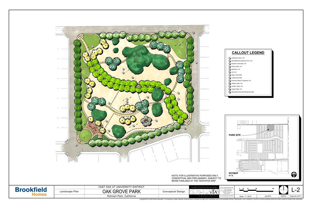

11 ATTACHMENT F: Oak Grove Park
DISCUSSION ON VACAVILLE S2 INVESTORS PROPERTY IN URBAN RESERVE
 Agenda Item No. 9C April 25, 2017 TO: FROM: SUBJECT: Honorable Mayor and City Council Attention: Jeremy Craig, Interim City Manager Barton Brierley, AICP, Community Development Director (Staff Contact:
CITY OF VACAVILLE PLANNING COMMISSION Agenda Item No. G.1 STAFF REPORT February 21, 2012 BRIGHTON LANDING SPECIFIC PLAN & DEVELOPMENT PROJECT
 CITY OF VACAVILLE PLANNING COMMISSION Agenda Item No. G.1 STAFF REPORT February 21, 2012 Staff Contact: Fred Buderi (707) 449-5307 TITLE: PURPOSE: BRIGHTON LANDING SPECIFIC PLAN & DEVELOPMENT PROJECT INFORMATIONAL
Department of Community Development. Planning and Environmental Review Division Revised Notice of Preparation
 Department of Community Development Michael J. Penrose, Acting Director Divisions Building Permits & Inspection Code Enforcement County Engineering Economic Development & Marketing Planning & Environmental
AWH REPORT OF THE PLANNING AND DEVELOPMENT DEPARTMENT FOR APPLICATION FOR REZONING ORDINANCE TO PLANNED UNIT DEVELOPMENT
 AWH REPORT OF THE PLANNING AND DEVELOPMENT DEPARTMENT FOR APPLICATION FOR REZONING ORDINANCE TO PLANNED UNIT DEVELOPMENT MAY 8, 2014 The Planning and Development Department hereby forwards to the Planning
CHAPTER 2 SUMMARY 1. PROJECT SUMMARY DATA
 CHAPTER 2 SUMMARY This is an Initial Study format used to determine, pursuant to CEQA Guidelines Section 15177, whether a project 1) is within the scope of a Master EIR (MEIR), 2) may result in additional
open public hearing and allow public comment request to continue LPA public hearing to January 16, 2014 at 10:30 am
 TODAY S AGENDA Work Session LPA Transmittal Public Hearing open public hearing and allow public comment request to continue LPA public hearing to January 16, 2014 at 10:30 am staff will issue a recommendation
Land Use element LAND USE POLICY AREAS ESTATE AND RURAL RESIDENTIAL AREAS/RURAL SHELDON AREA OLD TOWN ELK GROVE
 Land Use element Land Use is often considered the heart of the General Plan. The statement of future land uses describes how the City believes it should develop in the future where housing, shopping, open
 Land Use Item 1. Floodplain Areas, Water Quality, Detention & Private Open Space 2. Required Land Dedication for Neighborhood Park Planning Area Designation Map Area Code Gross Land Area in Acres Maximum
PROJECT DESCRIPTION. Providing a mix of housing options supporting a diversity of needs (800-1,600 sf 1-3 bd flats and Townhomes).
.") ROHNERT PARK Planned Development - Preliminary Application Project Site LOCATION MAP Project Site Rohnert Crossings is a acre mixed-use urban village proposed in the center of the city adjacent what will
ROHNERT PARK Planned Development - Preliminary Application Project Site LOCATION MAP Project Site Rohnert Crossings is a acre mixed-use urban village proposed in the center of the city adjacent what will
Gadsden County Planning Commission Agenda Request
 Date of Meeting: November 16, 2017 To: From: Through: Subject: Gadsden County Planning Commission Agenda Request Honorable Chairperson and Members of the Board Jill A. Jeglie, AICP, Senior Planner Clyde
Gold Line Bus Rapid Transit Transit Oriented Development (BRTOD) Helmo Station Area Plan
 Helmo Station Area Plan") Appendix F Gold Line Bus Rapid Transit Transit Oriented Development (BRTOD) Helmo Station Area Plan Introduction and Purpose of the Plan The Gold Line Bus Rapid Transit facility is an eleven-mile dedicated
Appendix F Gold Line Bus Rapid Transit Transit Oriented Development (BRTOD) Helmo Station Area Plan Introduction and Purpose of the Plan The Gold Line Bus Rapid Transit facility is an eleven-mile dedicated
2. Form and Character. 2.1 Introduction. 2.2 The Downtown Addition Plan. 2.1 Introduction
 2.1 Introduction 2.1 Introduction This section of the Specific Plan describes and illustrates the desired form, character and uses of the Downtown Addition and explains the underlying design principles.
Conceptual Review Agenda
 Conceptual Review Agenda Schedule for 02/27/17 to 02/27/17 281 Conference Room A Monday, February 27, 2017 Time Project Name Applicant Info Project Description Planner 9:30 419 Wood Street Multi-Family
CONSENT CALENDAR CITY PLANNING COMMISSION AGENDA ITEM: A.1-A.3 STAFF: STEVE TUCK
 Page 8 CONSENT CALENDAR CITY PLANNING COMMISSION AGENDA ITEM: A.1-A.3 STAFF: STEVE TUCK FILE NOS: 1. - CPC MPA 07-00308-A4MJ09 LEGISLATIVE 2. - CPC PUZ 09-00057 QUASI-JUDICIAL 3. - CPC PUD 09-00058 QUASI-JUDICIAL
Mariposa Lakes. Planned Community. Project Overview. Stockton, CA
 Planned Community Stockton, CA Project Overview March 2007 Summary of Proposed Community is a master-planned community proposed for development on approximately 3,810 acres in southeast Stockton. In 2004,
Land Use Element. policy areas are discussed in this Element:
 Land Use Element Land Use is often considered the heart of the General Plan. The statement of future land uses describes how the City believes it should develop in the future where housing, shopping, open
Rezoning Petition Pre-Hearing Staff Analysis May 21, 2018
 Rezoning Petition 2018-018 Pre-Hearing Staff Analysis May 21, 2018 REQUEST Current Zoning: R-5 (single family residential), R-5 HD-O (single family residential, historic district overlay) and B-2(CD) HD-O
CITY OF VACAVILLE PLANNING COMMISSION Item No. 8.A STAFF REPORT July 18, 2016 STAFF CONTACT: Amy Feagans, Contract Planner (707)
") CITY OF VACAVILLE PLANNING COMMISSION Item No. 8.A STAFF REPORT July 18, 2016 STAFF CONTACT: Amy Feagans, Contract Planner (707) 449-5140 TITLE: THE FARM AT ALAMO CREEK ENVIRONMENTAL IMPACT REPORT (EIR)
CITY OF VACAVILLE PLANNING COMMISSION Item No. 8.A STAFF REPORT July 18, 2016 STAFF CONTACT: Amy Feagans, Contract Planner (707) 449-5140 TITLE: THE FARM AT ALAMO CREEK ENVIRONMENTAL IMPACT REPORT (EIR)
Description of Preferred Alternative
 Chapter 2 Description of Preferred Alternative 2.1 Introduction This chapter of the programmatic Sammamish Town Center Sub-area Plan Final EIS provides a more detailed description of the Preferred Alternative
CONSENT CALENDAR CITY PLANNING COMMISSION AGENDA ITEM NO: A.1, A.2 STAFF: LARRY LARSEN
 Page 8 CONSENT CALENDAR CITY PLANNING COMMISSION AGENDA ITEM NO: A.1, A.2 STAFF: LARRY LARSEN FILE NO: CPC PUZ 14-00013 - QUASI-JUDICIAL FILE NO: CPC PUD 14-00014 QUASI-JUDICIAL PROJECT: APPLICANT: OWNER:
Asbury Chapel Subdivision Sketch Plan
 Asbury Chapel Subdivision Sketch Plan PART 1: PROJECT SUMMARY Applicant: NVR Inc. Project Size: +/- 76.13 acres Parcel Numbers: 02101112,02116101,02116112, 02116113 Current Zoning: Transitional Residential
LAND USE AMENDMENT CORNERSTONE (WARD 3) 60 STREET NE AND COUNTRY HILLS BOULEVARD NE MAP 26NE BYLAW 22D2017
 60 STREET NE AND COUNTRY HILLS BOULEVARD NE MAP 26NE BYLAW 22D2017") Page 1 of 14 EXECUTIVE SUMMARY This Land Use Amendment application covers an area of 43.76 hectares ± (108.14 acres ±) located in northeast Calgary, bound by Country Hills Boulevard NE to the south and
Page 1 of 14 EXECUTIVE SUMMARY This Land Use Amendment application covers an area of 43.76 hectares ± (108.14 acres ±) located in northeast Calgary, bound by Country Hills Boulevard NE to the south and
EXHIBIT B PROJECT NARRATIVE POULSBO MEADOWS
 EXHIBIT B PROJECT NARRATIVE POULSBO MEADOWS Name of Project: Poulsbo Meadows; A Planned Residential Development (PRD)/Plat Applicants Name: PBH Group LLC/Byron Harris PO Box 1010 Silverdale, WA 98038 Description
Narcoossee Roadway Corridor
 Community Meeting Narcoossee Roadway Corridor April 5, 2012 Meeting Agenda Purpose of Meeting Continuation of Study Update Process (Previous Meetings Oct. & Nov., 2011) Tonight s Objective Review Proposals
ECONOMIC DEVELOPMENT DISTRICT MASTER PLAN
 ECONOMIC DEVELOPMENT DISTRICT MASTER PLAN E Orange Ave Legend for the CIT Y OF MOUNT DORA/LAKE COUNT Y County Boundary Wekiva Corridor (Proposed Alignment) Public Land and Parks Park Public CityLimits
MAYFIELD WEST SECONDARY PLAN PHASE 2
 MAYFIELD WEST SECONDARY PLAN PHASE 2 Public Open House #3 February 25, 2010 Draft Preferred Land Use Scenario TOWN OF CALEDON PLANNING & DEVELOPMENT DEPARTMENT Open House Agenda TOWN OF CALEDON 1. Welcome
TOWN OF WINDSOR PLANNING COMMISSION STAFF REPORT SUMMARY. Tom Micheletti / Silverado Sonoma Vineyards LLC
 Agenda Item No. 12.1 TOWN OF WINDSOR PLANNING COMMISSION STAFF REPORT FILE: PRE 17-15 DATE: August 22, 2017 STAFF: Kim Jordan, Associate Planner SUMMARY Applicant/Owner: Tom Micheletti / Silverado Sonoma
KASPER. City of Georgetown, Texas PUD Planned Unit Development. December 30, 2015 Revised January 27, 2016
 KASPER City of Georgetown, Texas PUD Planned Unit Development December 30, 2015 Revised January 27, 2016 Applicant: Sentinel Land Company, LLC 4910 Campus Drive Newport Beach, CA Prepared by: SEC Planning
CITY OF VACAVILLE PLANNING COMMISSION Agenda Item No 7.A STAFF REPORT October 17, 2017 Staff Contact: Barton Brierley
 CITY OF VACAVILLE PLANNING MMISSION Agenda Item No 7.A STAFF PORT October 17, 2017 Staff Contact: Barton Brierley 707-449-5361 TITLE: VACAVILLE GENERAL PLAN AMENDMENT LATED TO THE FA AT ALAMO CEK URBAN
SONOMA LOCAL AGENCY FORMATION COMMISSION
 For accessibility assistance with any of the following documents, please contact Sonoma LAFCO at (707) 565-2577 or email us at cynthia.olson@sonoma-county.org. SONOMA LOCAL AGENCY FORMATION COMMISSION
Chesapeake Bay Critical Area Conservation Plan
 The Maryland-National Capital Park and Planning Commission Prince George s County Planning Department Development Review Division 301-952-3530 Note: Staff reports can be accessed at www.mncppc.org/pgco/planning/plan.htm.
COUNTY OF SACRAMENTO CALIFORNIA. PLNP Jackson Township Specific Plan. Workshop And Initiation of Environmental Review Process
 COUNTY OF SACRAMENTO CALIFORNIA #102 For the Agenda of: June 18, 2013 Timed: 2:00 PM To: From: Subject: Supervisorial District(s): Board of Supervisors Department of Community Development PLNP2011-00095.
PART 1: PROJECT SUMMARY. Proposed Land Use: 120 single-family lots. The application is Attachment A. The site plan is Attachment B.
 PART 1: PROJECT SUMMARY Applicant: JBH Development, LLC and Hopper Communities, INC Project Size: +/- 80.48 acres Parcel Number: 01513107, 01513108, 01513109, 01513113, 01513120, 01513121, 01513122, 01513124,
The Ritz-Carlton, Paradise Valley
 The Ritz-Carlton, Paradise Valley 7000 E. Lincoln Drive Keys to Success Community Conversation II June 4, 2015 RITZ-CARLTON PARADISE VALLEY Town Council Study Session June 4, 2015 General Plan 2012 Land
VANDEN MEADOWS SPECIFIC PLAN TABLE OF CONTENTS Page 1.0 INTRODUCTION SUMMARY Schools Foxboro Parkway
 0 VANDEN MEADOWS SPECIFIC PLAN TABLE OF CONTENTS Page 1.0 INTRODUCTION 6 1.1. SUMMARY 6 1.1.1. Schools 11 1.1.2. Foxboro Parkway 11 1.1.3. Improvements to Leisure Town Road 11 1.1.4. New Neighborhood Park
Planning Commission Staff Report Project Plan Approval Hearing Date: June 14, 2017
 Planning Commission Staff Report Project Plan Approval Hearing Date: June 14, 2017 ITEM 3 Peter Matson requests Project Plan Approval for an 80-acre mixed-use plan that includes 220 residential units and
Planning Commission Staff Report June 5, 2008
 Owner/Applicant Taylor Village Sacramento Investments Partners, LP c/o Kim Whitney 1792 Tribute Road #270 Sacramento, CA 95815 Staff Recommendation Planning Commission Staff Report Project: File: Request:
LOS ANGELES CITY PLANNING DEPARTMENT STAFF REPORT
 LOS ANGELES CITY PLANNING DEPARTMENT STAFF REPORT LOS ANGELES CITY PLANNING COMMISSION CASE NO: CPC 2006-9374 CRA CEQA: Exempt DATE: December 21, 2006 Location: Valley Plaza and Laurel Plaza TIME: after
Isabel Neighborhood Plan: Alternatives
 Isabel Neighborhood Plan: Alternatives Presented by: Lori Parks, Associate Planner February 2, 2015 Agenda 1. Background on BART to Livermore 2. Isabel Neighborhood Plan 3. Alternative Scenarios 4. General
Jackson Highway Master Plans
 Jackson Highway Master Plans West Jackson Highway Master Plan (PLNP2008-00240) Jackson Township Specific Plan (PLNP2011-00095) NewBridge Specific Plan (PLNP2010-00081) Mather South Community Master Plan
CITY COUNCIL STUDY SESSION MEMORANDUM
 City and County of Broomfield, Colorado CITY COUNCIL STUDY SESSION MEMORANDUM To: From: Prepared by: Mayor and City Council Charles Ozaki, City and County Manager Kevin Standbridge, Deputy City and County
NEWBRIDGE SPECIFIC PLAN PROJECT DESCRIPTION SEPTEMBER 24, 2012
 PROJECT DESCRIPTION SEPTEMBER 24, 2012 Project Location The NewBridge Specific Plan project area consists of 1,095.3 acres south of Mather Airport between Kiefer Boulevard and Jackson Road, west of Sunrise
WASHINGTON COUNTY OREGON
 WASHINGTON COUNTY OREGON LONG RANGE PLANNING DIVISION North Bethany Subarea Stream Corridors: Existing Regulations In Oregon, there is a distinct difference between the land use rules that apply in rural
CHUGIAK-EAGLE RIVER SITE-SPECIFIC LAND USE PLAN
 CHUGIAK-EAGLE RIVER SITE-SPECIFIC LAND USE PLAN JUNE 2010 Final Prepared for The Heritage Land Bank, Municipality of Anchorage by Agnew: :Beck Consulting www.agnewbeck.com 907.222.5424 Chugiak-Eagle River
Conservation Development
 Acknowledgements RIDEM: Scott Millar Anthony Lachowicz-Planning and Zoning Consultant Director of Planning 1 : a creative land use technique that allows a community to guide growth to the most appropriate
THE NE QUADRANT LAND USE PLAN
 THE NE QUADRANT LAND USE PLAN APPENDIX - VOLUME 3 APPEND. 9 TRANSPORTATION & APPEND. 13 DR/GR LAND USE Aug. 5, 2013 Barraco and Assoc., Inc. Stuart and Assoc. JMB Transportation Passarella and Assoc. THE
Fresh Kills Park in Regional Context
 Fresh Kills Park in Regional Context Fresh Kills Location On Staten Island Community District 1 THE SITE TODAY TRAVIS William T. Davis Wildlife Refuge New Jersey NEW SPRINGVILLE MOUND 3/4 Little Fresh
Applicant Name Phone / Fax / Address City State Zip Code . Property Owner Phone / Fax / Address City State Zip Code
 Master Development Plan Application Community Development Department City of Redmond 411 SW 9 th Street Redmond, Oregon 97756 541-923-7721 541-548-0706 FAX Master Development Plan Fee $38,862.52 File Number
Joint Study Session of the Sutter County. March 2, 2009
 Joint Study Session of the Sutter County Board of Supervisors and Planning Commission March 2, 2009 CURRENT APPLICATION General Plan Amendment Specific Plan Specific Plan Appendices Utility Plans Transit/AQ
ADMINISTRATION RECOMMENDATION 2016 November 03. That Calgary Planning Commission recommends APPROVAL of the proposed Land Use Amendment.
 Page 1 of 12 EXECUTIVE SUMMARY This Land Use Amendment application covers an area of 75.76 hectares ± (187.20 acres ±) located in northeast Calgary, bound by Stoney Trail NE to the north, 128 Avenue NE
RaC. RaD GlG. GlF. RaD GlE. CeA. RaE. RcD. GoF. GoF SkC. SkD. CfA. AdA. GoF. GoF. GoF. RcD. GgD. GoF. RaE GlE. RaE DbF. GoF. DbE. RaC.
 526300 527400 528500 529600 530700 531800 532900 534000 535100 4240200 4241300 4242400 4243500 4244600 4245700 ADRIAN DR FAIRWAY DR STATE FARM DR DOLORES DR HUDIS ST SANTA ALICIA DR Cotati PAGE ST ALTA
Glenborough at Easton Land Use Master Plan
 Land Use Framework November 30, 2007 2.0 LAND USE FRAME- WORK 2.1 LAND USE HISTORY and Setting Glenborough at Easton is located on property that was used for mining in the 19th and 20th centuries and rocket
Application Number: SD Project Name: Walton Farms Preliminary Subdivision (acting as Master Plan)
") STAFF REPORT Town of Clayton Planning Department 111 E. Second Street, Clayton, NC 27520 P.O. Box 879, Clayton, NC 27528 Phone: 919-553-5002 Fax: 919-553-1720 Planning Board May 22, 2017 Application Number:
STAFF REPORT Town of Clayton Planning Department 111 E. Second Street, Clayton, NC 27520 P.O. Box 879, Clayton, NC 27528 Phone: 919-553-5002 Fax: 919-553-1720 Planning Board May 22, 2017 Application Number:
COMMISSION ACTION FORM
 ITEM #: 6 DATE: 09-06-17 COMMISSION ACTION FORM REQUEST: Introduction and Initial Review of Proposed Amendments to the Ames Urban Fringe Future Land Map for the North Growth Gap Area BACKGROUND INFORMATION:
Planning Commission Staff Report Agenda Item No. 4 March 7, 2019
 DEPARTMENT OF PUBLIC WORKS AND PLANNING STEEN E. WHITE, DIRECTOR Planning Commission Staff Report Agenda Item No. 4 March 7, 2019 SUBJECT: General Plan Conformity Application Clovis Unified School District
New Partners for Smart Growth Conference February 5, 2010
 Dan Stroh, Planning Director City of Bellevue Planning and Community Development Bellevue, WA New Partners for Smart Growth Conference February 5, 2010 Summary of Project Long-range plan update for Bel-Red
MAYFIELD WEST SECONDARY PLAN PHASE 2
 MAYFIELD WEST SECONDARY PLAN PHASE 2 Council Information Workshop February 16, 2010 Draft Preferred Land Use Plan TOWN OF CALEDON PLANNING & DEVELOPMENT DEPARTMENT Workshop Agenda TOWN OF CALEDON 1. Welcome
Jackson Township Specific Plan Applicant Prepared Project Description Revised
 Jackson Township Specific Plan Applicant Prepared Project Description Revised 4-11-13 Project Location The proposed Plan Area, approximately 1391 acres, is located in southeastern Sacramento County, lying
LAND USE AMENDMENT CORNERSTONE (WARD 3) COUNTRY HILLS BOULEVARD AND STONEY TRAIL NE BYLAW 9D2017
 COUNTRY HILLS BOULEVARD AND STONEY TRAIL NE BYLAW 9D2017") Page 1 of 12 EXECUTIVE SUMMARY This Land Use Amendment application covers an area of 54.92 hectares ± (135.71 acres ±) located in northeast Calgary, bound by Country Hills Boulevard NE to the north and
Page 1 of 12 EXECUTIVE SUMMARY This Land Use Amendment application covers an area of 54.92 hectares ± (135.71 acres ±) located in northeast Calgary, bound by Country Hills Boulevard NE to the north and
Proposed Kenmount Hill CDS Amendment. Public Hearing October 25 th, 2018
 Proposed Kenmount Hill CDS Amendment Public Hearing October 25 th, 2018 History of Kenmount Hill Why Kenmount Hill? Why Now? We are a city with a vision for growth and the development of Kenmount Hill
TO: CITY COUNCIL DATE: MARCH 23,2009
 Report TO: CITY COUNCIL DATE: MARCH 23,2009 FROM: CITY MANAGER SUBJECT: MASTER DEVELOPMENT PLAN AMENDMENT FOR PASADENA CHRISTIAN SCHOOL AT 1515 NORTH LOS ROBLES AVENUE AND GENERAL PLAN AMENDMENT AND ZONE
Rezoning Petition Pre-Hearing Staff Analysis March 19, 2018
 Rezoning Petition 2017-171 Pre-Hearing Staff Analysis March 19, 2018 REQUEST Current Zoning: R-3 (single family residential) Proposed Zoning: MX-2 (INNOV) (mixed used, innovative) with five-year vested
PARISH OF ASCENSION OFFICE OF PLANNING AND DEVELOPMENT PLANNING DEPARTMENT. Joint Planning and Zoning Meeting
 1. Call To Order 2. Roll Call of Members 3. Chairman's Comments PARISH OF ASCENSION OFFICE OF PLANNING AND DEVELOPMENT PLANNING DEPARTMENT Joint Planning and Zoning Meeting January 11, 2017 6:00 PM Courthouse
Technical Appendix A, BCP Consistency with City s General Plan
 Technical Appendix A, BCP Consistency with City s General Plan Table of Contents A.1 Consistency Overview A.1.1 Purpose and Utility A.1.2 Consistency with the City s Guiding Principles for Community Plans
Eastcreek Farm. Planned Development Standards September, 2014
 Eastcreek Farm Planned Development Standards September, 2014 ekfarm Contents 01. General Standards 02. Residential Development Standards 03. Architectural Design Standards 04. Landscape Design Standards
FY Capital Improvement Program Arroyo Projects
 FY 219-223 Capital Improvement Program FY 218 FY 219 FY 22 FY 221 FY 222 FY 223 1 2 3 4 5 6 7 8 9 1 Hahamongna - Implement Master Plan - Oak Grove Area Improvements (7756) Hahamongna - Implement Master
Note: Staff reports can be accessed at Zone: I-3. Tier:
 The Maryland-National Capital Park and Planning Commission Prince George s County Planning Department Development Review Division 301-952-3530 Note: Staff reports can be accessed at www.mncppc.org/pgco/planning/plan.htm.
SAN RAFAEL GENERAL PLAN 2040 INTRODUCTION AND OVERVIEW
 SAN RAFAEL GENERAL PLAN 2040 INTRODUCTION AND OVERVIEW Steering Committee Presentation February 14, 2018 Purpose of General Plan Guide land use and development decisions Coordinate transportation, infrastructure,
SPECIFIC PLAN Requirements
 CITY OF LANCASTER PLANNING DEPARTMENT 44933 Fern Avenue, Lancaster, California 93534 (661) 723-6100 SPECIFIC PLAN Requirements Purpose The purpose of a specific plan is to provide for the logical development
Bostwick Road. Municipal Class Environmental Assessment. October 13, City of London. Bostwick Road Municipal Class Environmental Assessment
 Bostwick Road Municipal Class Environmental Assessment October 13, 2016 Welcome! Welcome to the first Public Information Centre for the Bostwick Road Municipal Class Environmental Assessment. Representatives
COMMUNITY DEVELOPMENT SERVICES PLANNING AND BUILDING DEPARTMENT PLACERVILLE OFFICE:
 COMMUNITY DEVELOPMENT SERVICES PLANNING AND BUILDING DEPARTMENT http://www.edcgov.us/devservices/ PLACERVILLE OFFICE: LAKE TAHOE OFFICE: 2850 Fair Lane Court, Placerville, CA 95667 924 B Emerald Bay Rd.
ARTICLE IV: DEVELOPMENT STANDARDS 404 MASTER PLANNING
 IV 13 404 MASTER PLANNING Master Planning through the Site Analysis (Master Planning Site Analysis) or Planned Development (Master Planning Planned Development) is provided to encourage development which
PG&E WINTERS GAS OPERATIONS AND TECHNICAL TRAINING CENTER
 PG&E WINTERS GAS OPERATIONS AND TECHNICAL TRAINING CENTER CEQA scoping Meeting March 19 th, 2014 Winters City Council Chambers - 6:30 pm AGENDA FOR THE MEETING 6:30 Welcome (John Donlevy) 6:40 Overview
5.13 RECREATION / OPEN SPACE
 5.13 RECREATION / OPEN SPACE The project includes the development of two 5+ acre public parks, four pocket parks and various trails. This complies with the Board of Supervisors established minimum standard
City Of Sparks Planning Commission Item
 Page 1 of 12 City Of Sparks Planning Commission Item Meeting Date: May17, 2012 Subject: PCN12009, Public Hearing, Consideration and possible action on a Master Plan Amendment and Rezoning request to change
4/8/2015 Item #10D Page 1
 MEETING DATE: April 8, 2015 PREPARED BY: Christy Villa, Associate Civil Engineer DEPT. DIRECTOR: Glenn Pruim DEPARTMENT: Public Works CITY MANAGER: Larry Watt SUBJECT: NORTH COAST HIGHWAY 101 STREETSCAPE
Communities Plan. Parkland-Spanaway-Midland. LUAC Review of Draft Policies
 Parkland-Spanaway-Midland Communities Plan LUAC Review of Draft Policies Presented by: Tiffany O Dell, Senior Planner Planning & Public Works Tiffany.Odell@co.pierce.wa.us 253-798-6859 November 1, 2017
TASK FORCE MEETING #10 SUMMARY
 TASK FORCE MEETING #10 SUMMARY CITY OF REDWOOD CITY INNER HARBOR SPECIFIC PLAN Tuesday, April 8, 2014 7:00 P.M. 9:30 P.M. Seaport Conference Center, 459 Seaport Court, Redwood City, CA 94063 TASK FORCE
Michael D, Harvey, Current Planning Supervisor. This project was originally approved in 2012 by the BOCC and is summarized as follows:
 PLANNING & INSPECTIONS DEPARTMENT Craig N. Benedict, AICP, Director Current Planning (919) 245-2575 (919) 644-3002 (FAX) www.orangecountync.gov 131 W. Margaret Lane Suite 201 P. O. Box 8181 Hillsborough,
AVANTI SOUTH. SPECIFIC PLAN June Prepared for: Applicant: Royal Investors Group, LLC
 AVANTI SOUTH SPECIFIC PLAN June 2018 Prepared for: Applicant: Royal Investors Group, LLC DRAFT AVANTI SOUTH SPECIFIC PLAN Applicant ROYAL INVESTORS GROUP, LLC 15821 Ventura Boulevard, Suite 460 Encino,
Welcome. Comprehensive Plan & Transportation Plan Open House November 7, 2012
 Welcome Comprehensive Plan & Transportation Plan Open House November 7, 2012 Agenda Proposed future land use plan Comprehensive Plan strategies Traffic forecasts Future traffic operations Possible future
Leonard s Beach Secondary Plan (Alcona North) Official Plan Amendment
 Official Plan Amendment") Leonard s Beach Secondary Plan (Alcona North) Official Plan Amendment Public Meeting Presentation August 14, 2013 Note: This document is for presentation purposes only. Please see Staff Report DSR-135-13
Leonard s Beach Secondary Plan (Alcona North) Official Plan Amendment Public Meeting Presentation August 14, 2013 Note: This document is for presentation purposes only. Please see Staff Report DSR-135-13
Neo-Traditional Overlay Application
 MAYOR AND CITY COUNCIL OF LAUREL DEPARTMENT OF ECONOMIC AND COMMUNITY DEVELOPMENT 8103 Sandy Spring Road Laurel, Maryland 20707 (301) 725-5300 Internet Address http://www.cityoflaurel.org E-mail: ecd@laurel.md.us
Honorable Mayor and Members of the City Council. Submitted by: Eric Angstadt, Director, Planning and Development
 Office of the City Manager ACTION CALENDAR January 29, 2013 To: From: Honorable Mayor and Members of the City Council Christine Daniel, City Manager Submitted by: Eric Angstadt, Director, Planning and
Town of Portola Valley General Plan. Nathhorst Triangle Area Plan
 Town of Portola Valley General Plan Amended December 10, 1997 Table of Contents Introduction... 1 Planning Area... 1 Objectives... 2 Principles... 2 Standards... 4 Description... 4 Community Commercial...
Vision Statement for the Town of Flower Mound Master Plan The Town of Flower Mound Master Plan furthers the established community based vision to:
 Vision Statement for the The furthers the established community based vision to: Preserve the country atmosphere and natural environment that makes Flower Mound a unique and desirable community; Mitigate
III. PROJECT DESCRIPTION
 III. PROJECT DESCRIPTION A. PROJECT LOCATION Regional Setting The project site is located in the southeast quadrant of the City of Chico in Butte County, California and is comprised of four parcels totaling
COLVER ROAD INDUSTRIAL CONCEPT PLAN
 COLVER ROAD INDUSTRIAL CONCEPT PLAN A CONCEPTUAL LAND USE AND TRANSPORTATION PLAN FOR TA-4 AN URBAN RESERVE AREA OF THE CITY TALENT City of Talent Adopted by City Council Resolution No., June, 2015 PART
Seattle City Council Central Staff - Memorandum
 Seattle City Council Central Staff - Memorandum Date: June 2, 2016 To: From: Subject: Councilmember Rob Johnson, Chair Councilmembers Mike O Brien and Lisa Herbold, Members Planning, Land Use and Zoning
PLANNING COMMISSION REPORT Public Hearing Item FINAL DEVELOPMENT PLAN FOR BAUER FARM; XPRESS WELLNESS URGENT CARE; 4700 OVERLAND DR (MKM)
") PC Staff Report 06/22/15 FDP-15-00108 Item No. 6-1 PC Staff Report 06/22/2015 ITEM NO. 6 PLANNING COMMISSION REPORT Public Hearing Item FINAL DEVELOPMENT PLAN FOR BAUER FARM; XPRESS WELLNESS URGENT CARE;
PC Staff Report 06/22/15 FDP-15-00108 Item No. 6-1 PC Staff Report 06/22/2015 ITEM NO. 6 PLANNING COMMISSION REPORT Public Hearing Item FINAL DEVELOPMENT PLAN FOR BAUER FARM; XPRESS WELLNESS URGENT CARE;
7,600 Residential Units 1,700,000 SF Non-Res 300-Room ALF 300-Room Hotel University School, Park, Civic parcels 1,889 ac flow-way/preservation
 4,763 ac undeveloped long-term AG use Over 75% characterized by non-native & invasive species Has severely degraded habitat functions 11,565 of frontage along Northlake Blvd. 1,687 of frontage along Beeline
CITY OF INVER GROVE HEIGHTS 8150 Barbara Avenue Inver Grove Heights, MN (651) Fax: (651)
 Fax: (651)") CITY OF INVER GROVE HEIGHTS 8150 Barbara Avenue Inver Grove Heights, MN 55077 (651) 450-2545 Fax: (651) 450-2502 www.invergroveheights.org SKETCH PLAN REVIEW APPLICATION FOR THE NORTHWEST AREA OVERLAY
CITY OF INVER GROVE HEIGHTS 8150 Barbara Avenue Inver Grove Heights, MN 55077 (651) 450-2545 Fax: (651) 450-2502 www.invergroveheights.org SKETCH PLAN REVIEW APPLICATION FOR THE NORTHWEST AREA OVERLAY
Rezoning Petition Post-Hearing Staff Analysis July 31, 2018
 Rezoning Petition 2018-044 Post-Hearing Staff Analysis July 31, 2018 REQUEST Current Zoning: R-3 (single family residential) Proposed Zoning: UR-2(CD) (urban residential, conditional) LOCATION Approximately
SUBMITTAL REQUIREMENTS
 WHEN PROCESS TYPE III IS USED References to Process Type III applications are found in several places in the Milton Municipal Code (MMC), indicating that the development, activity, or use, is permitted
REQUEST Current Zoning: O-15(CD) (office) Proposed Zoning: TOD-M(CD) (transit oriented development mixed-use, conditional)
 (office) Proposed Zoning: TOD-M(CD) (transit oriented development mixed-use, conditional)") Rezoning Petition 2016-117 Zoning Committee Recommendation January 4, 2017 REQUEST Current Zoning: O-15(CD) (office) Proposed Zoning: TOD-M(CD) (transit oriented development mixed-use, conditional) LOCATION
Rezoning Petition 2016-117 Zoning Committee Recommendation January 4, 2017 REQUEST Current Zoning: O-15(CD) (office) Proposed Zoning: TOD-M(CD) (transit oriented development mixed-use, conditional) LOCATION
Rezoning Petition Pre-Hearing Staff Analysis July 16, 2018
 Rezoning Petition 2018-044 Pre-Hearing Staff Analysis July 16, 2018 REQUEST Current Zoning: R-3 (single family residential) Proposed Zoning: UR-2(CD) (urban residential, conditional) LOCATION Approximately
Approved: CITY OF ARDEN HILLS, MINNESOTA PLANNING COMMISSION WEDNESDAY, AUGUST 5, :30 P.M. - ARDEN HILLS CITY HALL
 Approved: CITY OF ARDEN HILLS, MINNESOTA PLANNING COMMISSION WEDNESDAY, AUGUST 5, 2015 6:30 P.M. - ARDEN HILLS CITY HALL PLANNING CASES A. Planning Case 15-016; Final Planned Unit Development Arden Plaza;
City Council Special Meeting AGENDA ITEM NO. C.
 City Council Special Meeting AGENDA ITEM NO. C. DATE: 01/04/2019 TO: Honorable Mayor and City Council Members SUBJECT: Transit Villages Specific Plan project Study Session (Development Services Director
TEN MILE PLANNING COMMISSION AGENDA January 10, :30 p.m. Buffalo Mountain Meeting Room, County Commons 0037 Peak One Dr., SCR 1005, Frisco, CO
 PLANNING DEPARTMENT 970.668.4200 0037 Peak One Dr. PO Box 5660 www.summitcountyco.gov Frisco, CO 80443 TEN MILE PLANNING COMMISSION AGENDA January 10, 2019-5:30 p.m. Buffalo Mountain Meeting Room, County
A.9. Cannon River. Campostella Park. Adjacent Industrial & City Facility Uses
 Campostella Park Classification: Nature Area 14 acres Character: This park is an undeveloped, heavily wooded natural open space park located along the Cannon River, just to the southwest of Babcock Park