THE NE QUADRANT LAND USE PLAN
|
|
|
- Shana Bertina Whitehead
- 5 years ago
- Views:
Transcription

1 THE NE QUADRANT LAND USE PLAN APPENDIX - VOLUME 3 APPEND. 9 TRANSPORTATION & APPEND. 13 DR/GR LAND USE Aug. 5, 2013 Barraco and Assoc., Inc. Stuart and Assoc. JMB Transportation Passarella and Assoc.
2 THE NE QUADRANT LAND USE PLAN LAND USE PLAN APPENDIX 09.0 TRANSPORTATION July 17, 2013 Barraco and Ass., Inc. Stuart and Ass. JMB Transportation Passarella and Ass.
3 Appendix 09.0 Transportation Appendix 09.01! NE Quadrant Transportation Evaluation!!! ! JMB Engineering, report to the City of Bonita Springs; 07/13 Appendix 09.02! 2035 Long Range Transportation Plan!!! 09.01! 2035 Long Range Transporation Plan, Table 12-1; 05/13; MPO,!!!!! THE NE QUADRANT LAND USE PLAN Barraco and Ass., Inc. Stuart and Ass., Inc. JMB Transportation Passarella and Ass.
4 Appendix NE Quadrant Transportation Evaluation THE NE QUADRANT LAND USE PLAN Barraco and Ass., Inc. Stuart and Ass., Inc. JMB Transportation Passarella and Ass.
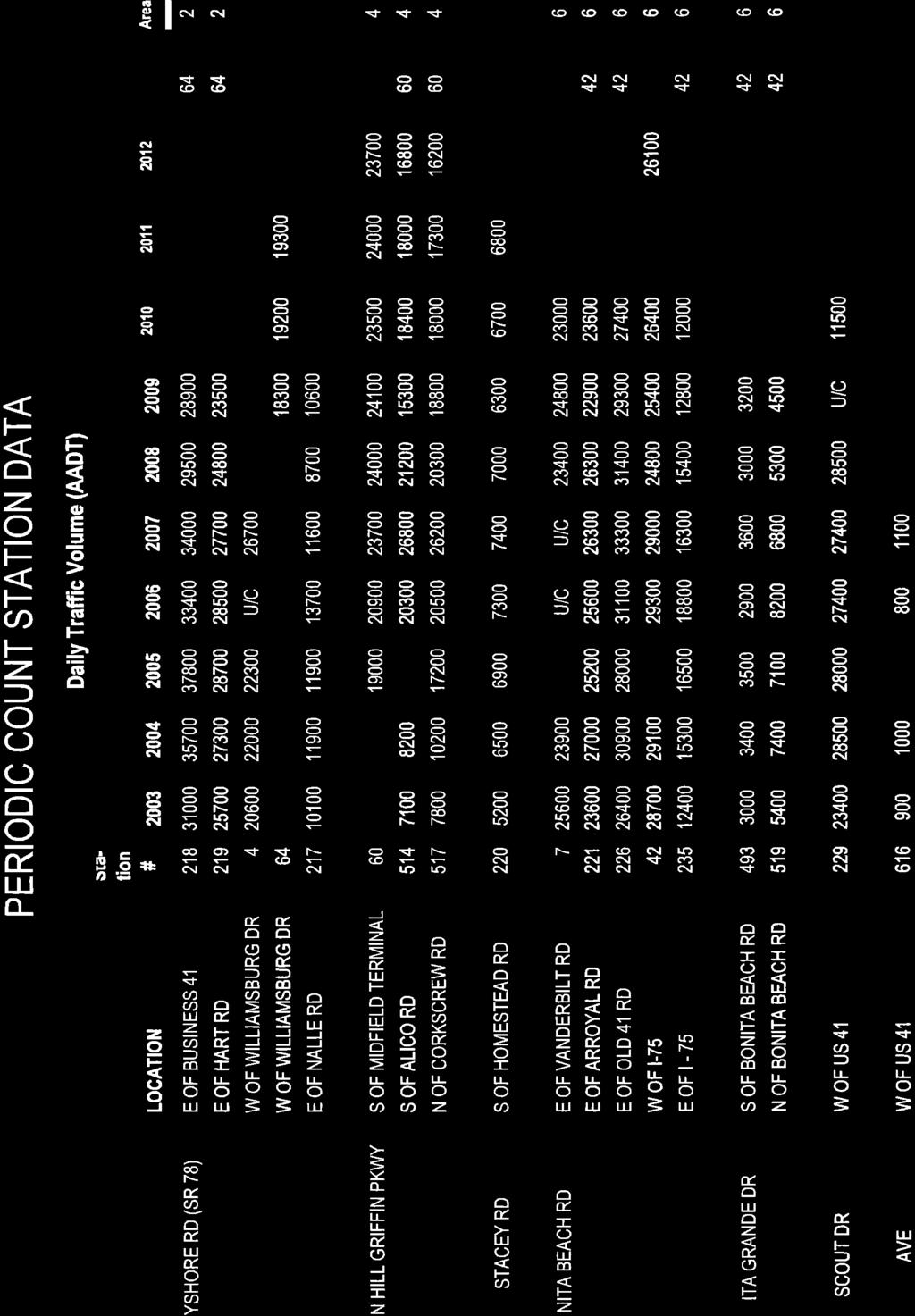
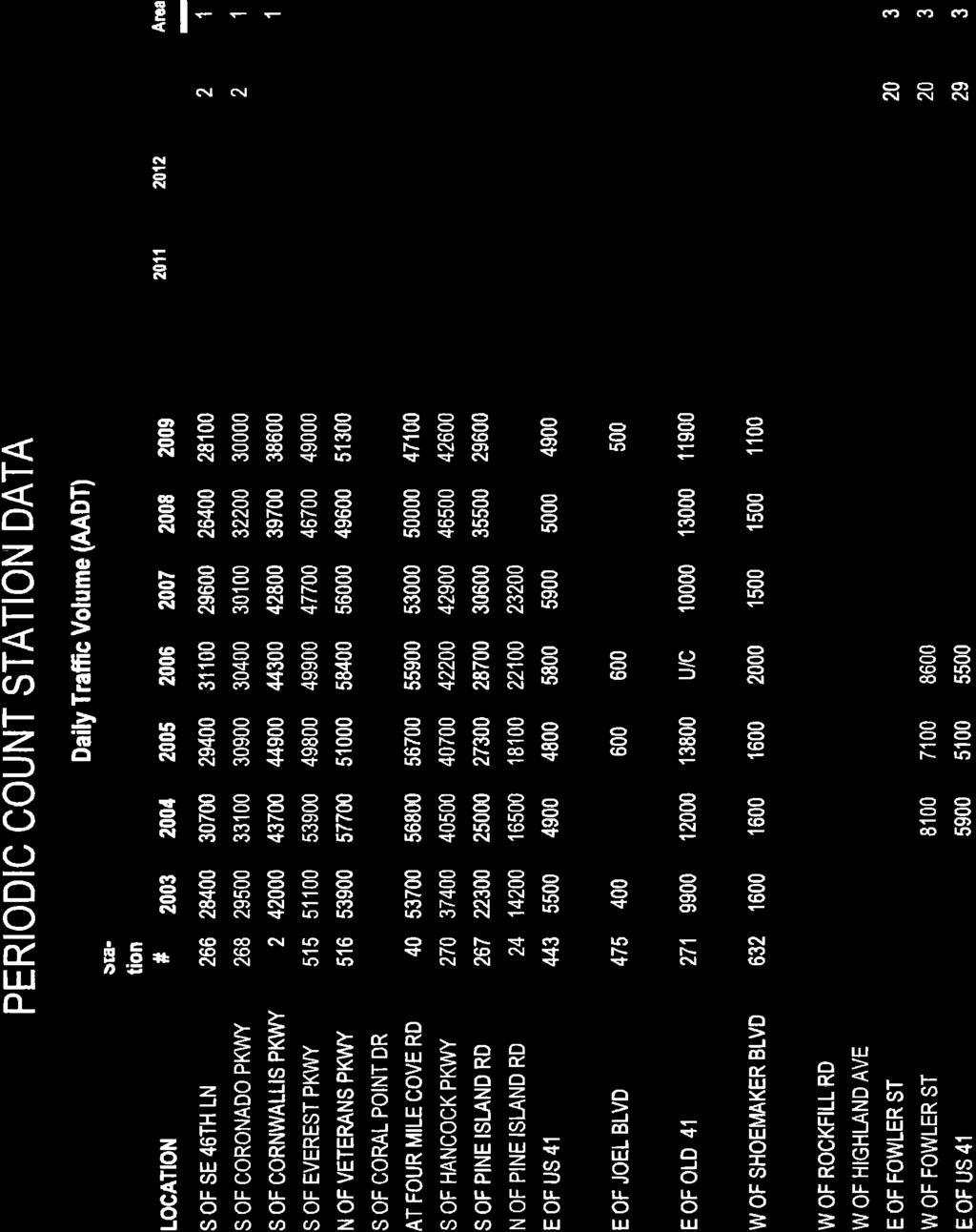
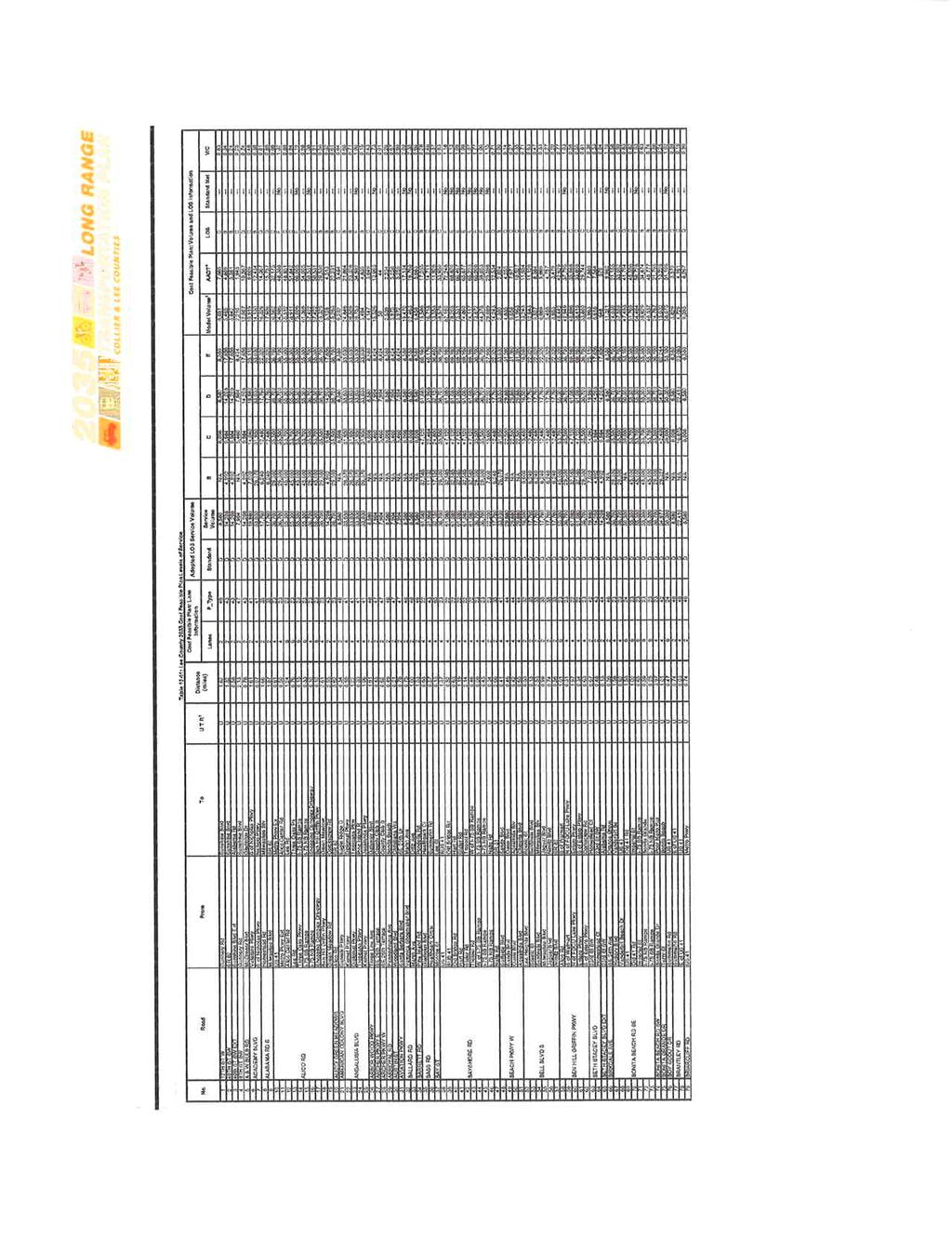
5 Transportation Element Existing 2013 Traffic Demands & Needs The study area's current traffic demands were established by conducting link-specific traffic counts, as well as obtaining data on file with the Lee County Department of Transportation (LDOT). The 2013 traffic volumes were compiled and adjusted to reflect peak season conditions for each link within the limits of the study area, which are summarized on Table T-2A. Also described on Table T-2A are the links' current classifications (e.g., 2 lane arterial, 2 lane collector, etc.) and service volume capacities. As shown, the 2013 peak season traffic demand on East Terry Street exceeds the "adopted" maximum carrying capacity of the 2-lane road (i.e., LOS E is 12,500 ADT). As determined, the current volume/capacity ratio on East Terry Street is v/c = 1.03, which implies the roadway is marginally operating at LOS F. However, it is important to note that the link-specific service volume thresholds were set forth by the Lee County 2035 Long Range Transportation Plan (2035 LRTP), which relied upon Generalized Service Volume Tables. In doing so, the LRTP may have understated the corridor's actual carrying capacity for that segment between I-75 and Bonita Grande Drive. It is recommended that a more detailed approach to determining that segment's true carrying capacity be conducted by the City in order to better determine when roadway improvements are needed. Future Traffic Demands & Needs per the 2035 Lee County LRTP The 2035 traffic demands were previously determined as part of the Lee County 2035 Long Range Transportation Plan (LRTP). The 2035 traffic projections reflect the build-out of all "entitled" land uses contained within and surrounding the study area, except for a 2,000 student public school that is planned at the intersection of Bonita Grande Drive/Dewey Street. The 2035 LRTP traffic projections are summarized on Table T-2A. The 2035 LRTP indicates a need for widening Bonita Grande Drive (between Bonita Beach Road and E. Terry Street) and East Terry Street (between Imperial Street and Bonita Grande Drive) and Bonita Beach Road (between I-75 and Bonita Grande Drive). It is important to note that these roadway improvements are identified as a need based upon the build-out of the current land use entitlements within and surrounding the study area. The 2035 LRTP determined that Bonita Grande Drive and East Terry Street will need to be widened to 4-lanes with intersection improvements, and Bonita Beach Road will need to be widened to 6-lanes and the westbound-to-northbound I-75 on-ramp will need to be improved, as well as other necessary intersection improvements. Table T-2A depicts the Existing + Planned Road Network and its service volume capacities Traffic Demands & Needs - Existing Land Use Build-out (2,631 D.U.'s & Public School) In order to determine the 2035 traffic conditions that reflect the build-out of the remaining entitled land uses, the traffic demand estimates for the remaining undeveloped parcels were added to 2035 background traffic forecasts. That is, traffic that will be generated by the remaining entitled ;development was first estimated based upon adopted transportation planning practices, and then the traffic was assigned to the surrounding road network based upon the established travel patterns for this area. Table T-1A provides a detail of the estimated trips associated with the remaining development of 752 dwelling
6 units and the 2,000 student public school. Table T-2A provides a summary of the 2035 background plus estimated traffic demands for each road link. Also shown on Table T-2A are the roadway links' adopted service volume capacities and the projected level of service (LOS) for existing network conditions and for the 2035 LRTP Network. As determined, all roadways within the study area will operate at acceptable levels of service for 2035 traffic conditions for build-out of the existing land uses on the LRTP Network as summarized on Table T-2A and depicted on Figure T-2A LRTP Needed Development Scenario Road Network Improvements 2,631 D.U.'s and Public School 4-lane East Terry Street None (Refer to Table T-2A & Fig T-2A) (Imperial to Bonita Grande Dr) 4-lane Bonita Grande Drive (Bonita Beach Rd to E. Terry) 6-lane Bonita Beach Road (I-75 to Bonita Grande Dr) 2035 Traffic Demands & Needs - Proposed Build-Out (5,000, 7,500 and 10,000 D.U.'s & Public School) The 2035 traffic demands associated with the potential development scenarios of 5,000, 7,500 and 10,000 dwelling units with the public school were estimated using the same methods as previously discussed. That is, traffic demands that will be generated by the proposed land use changes were first estimated (see Tables T-1B, T-1C, & T-1D). The estimated traffic was then assigned to the surrounding E +P road network based upon the expected travel patterns. Tables T-2B, T-2C and T-2D provide a summary of the 2035 background plus estimated traffic demands for each road link for the development potential of 5,000, 7,500 and 10,000 dwelling units, respectively. Also shown on those tables are the roadway links' adopted service volume capacities and the projected level of service (LOS) for 2035 LRTP Network conditions and the 2035 LRTP + Proposed Network Improvements. As determined, all roadways within the study area will operate at acceptable levels of service for 2035 for build-out as summarized on Tables T-2B thru T-2D and depicted on Figures T-2B thru T-2D. Additional road network improvements that will be required to support the development of the 5,000, 7,500 and 10,000 dwelling units and public school are summarized below LRTP Needed Development Scenario Road Network Improvements 5,000 D.U.'s and Public School 4-lane East Terry Street North/South 2-lane Road Parallel to Morton Ave (Refer to Table T-2B & Fig T-2B) (Imperial to Bonita Grande Dr) (E. Terry to Dewey St) 4-lane Bonita Grande Drive (Bonita Beach Rd to E. Terry) 6-lane Bonita Beach Road (I-75 to Bonita Grande Dr)
7 2035 LRTP Needed Development Scenario Road Network Improvements 7,500 D.U.'s and Public School 4-lane East Terry Street North/South 2-lane Road Parallel to Morton Ave (Refer to Table T-2C & Fig T-2C) (Imperial to Bonita Grande Dr) (E. Terry to Morton Ave E/W Extension) 4-lane Bonita Grande Drive (Bonita Beach Rd to E. Terry) Morton Street East/West 2-lane Extension (Morton Ave to Bonita Grande Dr) 6-lane Bonita Beach Road (I-75 to Bonita Grande Dr) 2035 LRTP Needed Development Scenario Road Network Improvements 10,000 D.U.'s and Public School 4-lane East Terry Street North/South 2-lane Road Parallel to Morton Ave (Refer to Table T-2D & Fig T-2D) (Imperial to Bonita Grande Dr) (E. Terry to Morton Ave E/W Extension) 4-lane Bonita Grande Drive (Bonita Beach Rd to E. Terry) Morton Street East/West 2-lane Extension (Morton Ave to Bonita Grande Dr) 6-lane Bonita Beach Road (I-75 to Bonita Grande Dr)
8
9
10
11
12
13


14
15
16
17
18
19
20
21


22
23
24
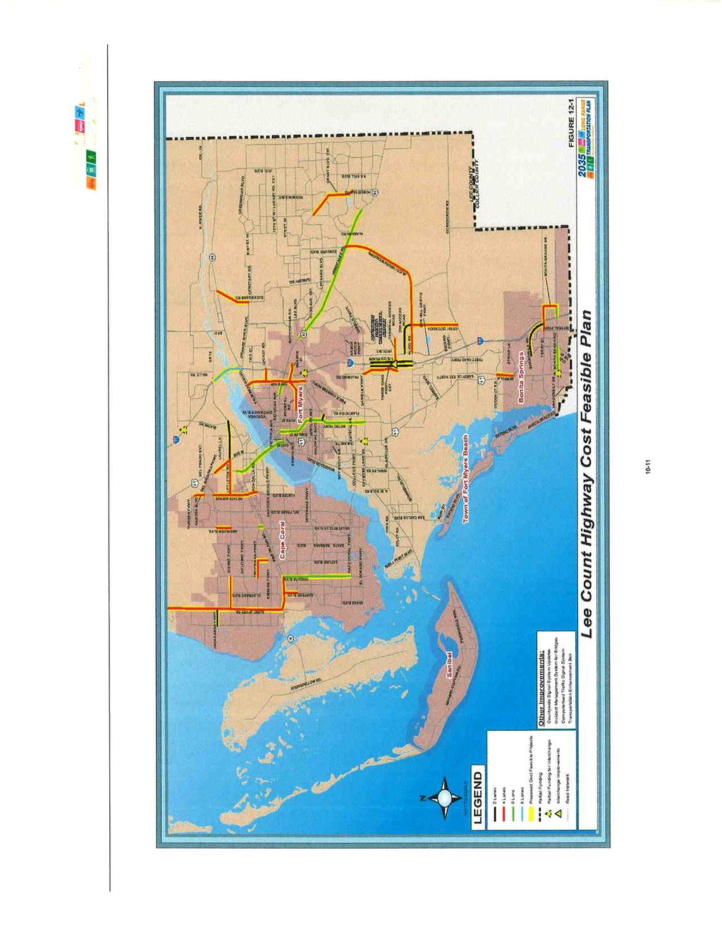
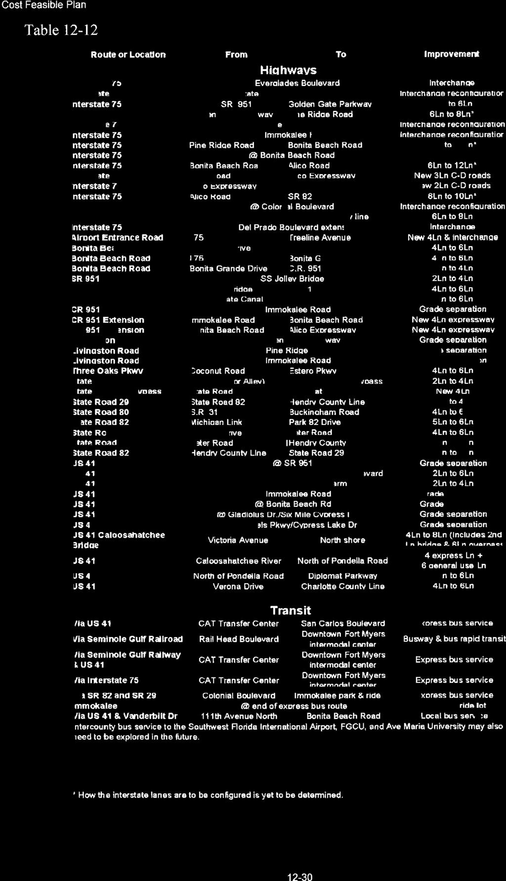
25 Appendix Long Range Transportation Plan THE NE QUADRANT LAND USE PLAN Barraco and Ass., Inc. Stuart and Ass., Inc. JMB Transportation Passarella and Ass.
26
27
28
29
30
31
32

33
34
35
36
37 THE NE QUADRANT LAND USE PLAN APPENDIX 13 - DR/GR STATUS QUO - THE 2700 UNIT BUILD OUT SCENARIO Aug. 5, 2013 Barraco and Ass., Inc. Stuart and Ass. JMB Transportation Passarella and Ass.
38 Appendix 13.0 DR/GR Status Quo Appendix 13.01! Appendix 13.02! Appendix 13.03! Appendix 13.04! Appendix 13.05! Appendix 13.06! The Bonita Springs Future Land Use Map Recommended FLUM Amendments - by Strap Number Alt. NE Quadrant Land Use Maps , 4800 & 7300 Units Bonita Springs Impact Fee Schedule Alt. Land Use Revenues & Program Allocations Table Study Area Density Calculations!!! THE NE QUADRANT LAND USE PLAN Barraco and Ass., Inc. Stuart and Ass., Inc. JMB Transportation Passarella and Ass.
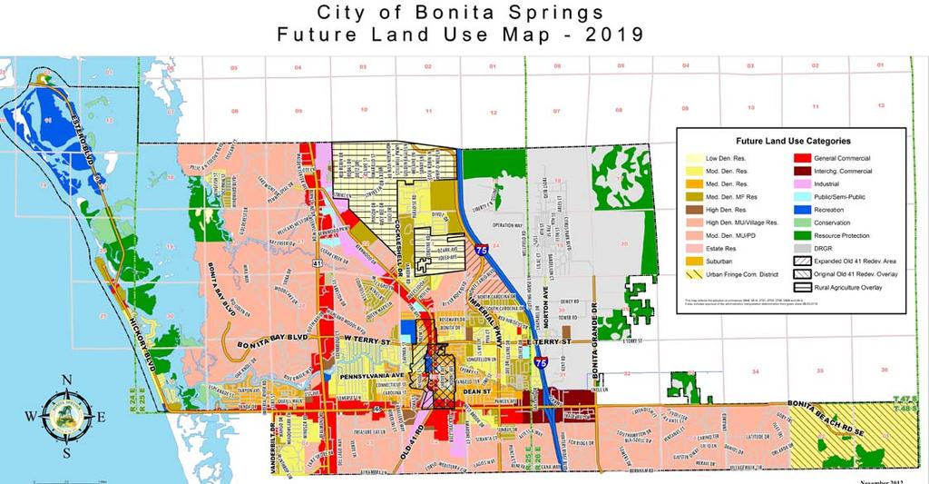
39 Appendix 13.01! The Bonita Springs Future Land Use Map THE NE QUADRANT LAND USE PLAN Barraco and Ass., Inc. Stuart and Ass., Inc. JMB Transportation Passarella and Ass.
40
41 Appendix 13.02! Strap Number Recommended FLUM Amendments - by THE NE QUADRANT LAND USE PLAN Barraco and Ass., Inc. Stuart and Ass., Inc. JMB Transportation Passarella and Ass.
42 RECOMMENDED FLUM CORRECTIONS Semi-Public Land Use: B LIBERTY YOUTH RANCH LLC B BONITA SPRINGS UTILITIES INC B BONITA SPRINGS UTILITIES INC B BONITA SPRINGS UTILITIES INC B BONITA SPRINGS UTILITIES INC B FLORIDA POWER + LIGHT CO B A PINNACLE TOWERS INC B COMCAST CABLEVISION B LEE COUNTY DIST SCHOOL BOARD B STATE OF FL DOT B STATE OF FL DOT B STATE OF FL DOT B STATE OF FL DOT B CITY OF BONITA SPRINGS B SOUTH COUNTY FAMILY YMCA INC B A UNITED TELEPHONE CO OF FL Low Density Residential Land Use: Bella Villa S/D Moderate Density Residential Land Use: Sun Village Estates, Morton Grove, Bonita East 20 Medium Density Residential Land Use: Sec. 19 less parcels Citrus Rental Park Resource Protection Land Use: B SFI EAGLE LAND LLC
43 Appendix 13.03! Alt. NE Quadrant Land Use Maps , 4800 & 7300 Units THE NE QUADRANT LAND USE PLAN Barraco and Ass., Inc. Stuart and Ass., Inc. JMB Transportation Passarella and Ass.
44 PUBLIC & SEMI-PUBLIC 1., 3. & 5. ESTATE RESIDENTIAL 1 ac., 3 ac. per & 5 acres per unit IMPERIAL DISTRICT MDR. Note 1 N N Imperial District 2300 Units w./ Corrective Amendments N. B. IMPERIAL DISTRICT MIXED USE OVERLAY N. Neighborhood B. Core Business LOW DENSITY RESIDENTIAL MODERATE DENSITY RESIDENTIAL MEDIUM DENSITY RESIDENTIAL CONSERVATION RESOURCE PROTECTION GREENWAY RESOURCE PROTECTION N. Neighborhood Mixed Use B. Core Business Mixed Use MDR 1. Private Utility Plants & Facilities By Right
45 PUBLIC & SEMI-PUBLIC 1., 3. & 5. ESTATE RESIDENTIAL 1 ac., 3 ac. per & 5 acres per unit IMPERIAL DISTRICT MDR. Note 1 N N Imperial District 4800 Units w./ Corrective Amendments N. B. IMPERIAL DISTRICT MIXED USE OVERLAY N. Neighborhood B. Core Business LOW DENSITY RESIDENTIAL MODERATE DENSITY RESIDENTIAL MEDIUM DENSITY RESIDENTIAL CONSERVATION RESOURCE PROTECTION GREENWAY RESOURCE PROTECTION N. Neighborhood Mixed Use B. Core Business Mixed Use MDR 1. Private Utility Plants & Facilities By Right

46 PUBLIC & SEMI-PUBLIC C.1 C.4 1. C.2 MDR. Note 1 C.3 Imperial District 6300 Units w./ Corrective Amendments C.8 1. C.9 C N. N. B. C.5 C.6 5. C.7 N. C.11. C.12 1., 3. & 5. N. B. ESTATE RESIDENTIAL 1 ac., 3 ac. per & 5 acres per unit IMPERIAL DISTRICT IMPERIAL DISTRICT MIXED USE OVERLAY N. Neighborhood B. Core Business LOW DENSITY RESIDENTIAL MODERATE DENSITY RESIDENTIAL MEDIUM DENSITY RESIDENTIAL CONSERVATION RESOURCE PROTECTION GREENWAY RESOURCE PROTECTION N. Neighborhood Mixed Use B. Core Business Mixed Use MDR 1. Private Utility Plants & Facilities By Right
47 Appendix 13.04! Bonita Springs Impact Fee Schedule THE NE QUADRANT LAND USE PLAN Barraco and Ass., Inc. Stuart and Ass., Inc. JMB Transportation Passarella and Ass.
48 Stuart and Associates. Planning Design Services The NE Quadrant Land Use Plan Bonita Springs Building Permit Fees: $ Bonita Springs Impact Fee Schedule: % Composition Impact Fees - Road: * Single Family $ 8, % * MF $ 6, * Retail $ 12, per 1000 SF Impact Fees - Regional Parks: * Single Family $ * MF $ Impact Fees - Community Parks: * Single Family $ % * MF $ Impact Fees - Schools: * Single Family $ % * MF $ Impact Fees - Fire: * Single Family $ % * MF $ * Retail $ per 1000 SF Impact Fees - EMS: * Single Family $ * MF $ * Retail $ per 1000 SF TOTAL PER UNIT SF IMPACT FEES $ 11, includes 3% TOTAL PER UNIT MF IMPACT FEES $ 7, includes 3% TOTAL RETAIL IMPACT FEES $ 13,645 per 1000 SF +3%
49 Appendix 13.05! Alt. Land Use Revenues & Program Allocations Table THE NE QUADRANT LAND USE PLAN Barraco and Ass., Inc. Stuart and Ass., Inc. JMB Transportation Passarella and Ass.
50 Stuart and Associates. Planning Design Services The NE Quadrant Land Use Plan NE QUAD. TOTAL FEES & ASSESSMENT REVENUES BY LAND USE MODEL NUMBER OF UNITS * SF * MF * Non-residential TOTAL BLDG PERMIT FEES $ 6,142,500 $ 733,200 $ 2,242,500 $ 4,680,000 $ 7,117,500 TOTAL IMPACT FEES * SF $ 56,390,967 $ 8,413,890 $ 20,587,179 $ 42,964,547 $ 57,174,175 * MF $ 9,427,998 $ 3,441,967 $ 7,183,236 $ 16,386,758 * Retail $ 2,729,088 $ 702,740 $ 1,364,544 $ 3,411,360 TOTAL IMPACT & BLDG. FEES $ 74,690,553 $ 9,147,090 $ 26,974,386 $ 56,192,327 $ 84,089,793 DISTRICT Municipal Service Unit * Unit Cost $ 5,000 $ 5,000 $ 5,000 $ 5,000 * Total Msu Revenues $ 31,500,000 $ 11,500,000 $ 24,000,000 $ 36,500,000 TOTAL NE QUAD FEES & MSU REVENUES $ 106,190,553 $ 9,147,090 $ 38,474,386 $ 80,192,327 $ 120,589,793 ANNUAL CITY AD VALOREM REVENUES $ 2,211,300 $ 188,000 $ 807,300 $ 1,684,800 $ 2,562,300 ANNUAL CITY SPECIAL DRAINAGE MIL $ 1,216,215 $ 103,400 $ 444,015 $ 926,640 $ 1,409,265 ANNUAL BONITA FIRE DISTRICT $ 4,942,919 $ 420,236 $ 1,804,558 $ 3,766,033 $ 5,727,509 ANNUAL SFWMD $948,427 $80,633 $ 346,251 $ 722,611 $ 1,098, NEW UNITS - Impact & MSU Fees: CITY IMPACT FEES ALLOCATION: Total Impact Fees $ 74,690,553 Roads 80.0% $ 59,752,443 Regional & Community Parks 8.6% $ 6,423,388 Schools 7.0% $ 5,238,967 Fire/EMS 4.4% $ 3,250,990 MUNICIPAL SERVICE UNIT FEES ALLOCATION: District Service Unit Fees $ 31,500,000 Solar Power Cost Per Credit $ 5,000 2 Credits Per Solar Unit $ 10,000 Number of District Solar Units 800 Solar Credit Unit Total Value Total Net MSU Fees $ 31,500,000 MSU IMPROVEMENT PROGRAM Program Budget MSU Internal % MSU Fees Impact Fees Total Fees Adjusted Municipal Service Unit $ 31,500,000 $ 74,690,553 $ 106,190,553 Drainage & Water Quality Projects $ 5,000,000 14% $ 4,410,000 $ 4,410,000 Multi-functional Park Property Acquisition $ 6,000,000 20% $ 6,300,000 $ 6,423,388 $ 12,723,388 Terry St./Bonita Bch. Rd. Landscape $ 1,200,000 6% $ 1,890,000 $ 1,890,000 Road Improvements (Terry/Bonita Gr.) $ 117,750,000 60% $ 18,900,000 $ 59,752,443 $ 78,652,443 * District Local Streets $ (7,750,000) * E. Terry/Flyover/Bonita Grande
51 Appendix 13.06! Study Area Density Calculations THE NE QUADRANT LAND USE PLAN Barraco and Ass., Inc. Stuart and Ass., Inc. JMB Transportation Passarella and Ass.
52 NEW UNIT PER ACRE DENSITY: Bonus Density DENSITY CALCULATIONS AREA MORTON AVE.: * Net Land Use Area TERRY STR.: * Net Land Use Area TOTAL UNIT PER ACRE DESNITY: DENSITY CALCULATIONS MORTON AVE.: * Net Land Use Area TERRY STR.: * Net Land Use Area
I-75 Overpass Study Summary
 I-75 Overpass Study Summary Sarasota County Transportation Planning evaluated various I-75 Overpass alternatives between University Parkway and Fruitville Road. Additionally, a consultant, Hanson Professional
14 October 10, 2012 Public Hearing APPLICANT: MPB, INC
 14 October 10, 2012 Public Hearing APPLICANT: MPB, INC PROPERTY OWNER: MUNDEN & ASSOCIATES, LP STAFF PLANNER: Karen Prochilo REQUEST: Conditional Change of Zoning (AG-1 & AG-2 to Conditional O-2) ADDRESS
NORTH-SOUTH CORRIDOR STUDY EXECUTIVE SUMMARY. Executive Summary
 Executive Summary Background As congestion continues to affect mobility in the region, the Ozarks Transportation Organization (OTO) is particularly concerned with traffic movement. The North-South Corridor
MEMORANDUM AGENDA ITEM #6c
 South Florida Regional Planning Council MEMORANDUM AGENDA ITEM #6c DATE: FEBRUARY 1, 2010 TO: FROM: SUBJECT: COUNCIL MEMBERS STAFF CITY OF PARKLAND PROPOSED COMPREHENSIVE PLAN AMENDMENT (ALTERNATIVE REVIEW)
CITY OF ROHNERT PARK CITY COUNCIL AGENDA REPORT
 Mission Statement We Care for Our Residents by Working Together to Build a Better Community for Today and Tomorrow. CITY OF ROHNERT PARK CITY COUNCIL AGENDA REPORT ITEM NO. 5 Meeting Date: July 23, 2013
CITY OF LOS ANGELES INTER-DEPARTMENTAL CORRESPONDENCE
 CITY OF LOS ANGELES INTER-DEPARTMENTAL CORRESPONDENCE 20000 Prairie St. DOT Case No. 41443 Date: November 5, 2014 To: R. Nicolas Brown, Associate Zoning Administrator Department of City Planning From:
Baumgarten MPUD. Exhibit 3 Evaluation Criteria
 Pursuant to LDC subsections 10.02.13 B, 10.02.08 F and Chapter 3 G. of the Administrative Code, staff s analysis and recommendation to the Planning Commission, and the Planning Commission s recommendation
112th Avenue Light Rail Options Concept Design Report JUNE 2010 PREPARED FOR PREPARED BY TBG PGH
 112th Avenue Light Rail Options Concept Design Report JUNE 2010 PREPARED FOR PREPARED BY TBG060310124909PGH C ontents Introduction 1 Project Overview 1 Public Involvement and Technical Coordination 4 Description
OP Council Resolution June 16, Planning and Development Services
 OP-08-01 Council Resolution June 16, 2008 Planning and Development Services Kingsgate Landing Outline Plan Table of Contents 1.0 Introduction 1 1.1 Purpose of Plan 1 1.2 Plan Area Location 1 1.3 Ownership
AWH REPORT OF THE PLANNING AND DEVELOPMENT DEPARTMENT FOR APPLICATION FOR REZONING ORDINANCE TO PLANNED UNIT DEVELOPMENT
 AWH REPORT OF THE PLANNING AND DEVELOPMENT DEPARTMENT FOR APPLICATION FOR REZONING ORDINANCE TO PLANNED UNIT DEVELOPMENT MAY 8, 2014 The Planning and Development Department hereby forwards to the Planning
Description of Preferred Alternative
 Chapter 2 Description of Preferred Alternative 2.1 Introduction This chapter of the programmatic Sammamish Town Center Sub-area Plan Final EIS provides a more detailed description of the Preferred Alternative
PLANNING COMMISSION. Submitted
 PLANNING COMMISSION City Hall 1275 Main Street El Centro, CA 92243 Submitted PLANNING COMMISSION ACTION ITEM (1844) Meeting: 05/10/16 12:00 AM Department: Community Development Category: Public Hearing
8 February 9, 2011 Public Hearing APPLICANT: 7-ELEVEN, INC.
 . 8 February 9, 2011 Public Hearing APPLICANT: REQUEST: Conditional Use Permit for an automobile service station with a convenience store ADDRESS / DESCRIPTION: 2448 Nimmo Parkway PROPERTY OWNER: COURTHOUSE
CITY-COUNTY PLANNING BOARD DRAFT STAFF REPORT
 CITY-COUNTY PLANNING BOARD DRAFT STAFF REPORT PETITION INFORMATION Docket # W-3174 Staff Aaron King Petitioner(s) O Reilly Auto Parts Owner(s) Glenn Crossing Associates, LLC Subject Property Portion of
3. Project Description
 3.1 PROJECT LOCATION The Platinum Triangle (herein after also referred to as the Project Area ) is located at the confluence of the Interstate 5 (I-5 Freeway) and the State Route 57 (SR-57 Freeway), in
Dayton Transportation Plan 2016 Update
 WENCK File #3164-30 February 9, 2016 Dayton Transportation Plan 2016 Update Prepared for: City of Dayton, MN 12260 S. Diamond Lake Road Dayton, MN 55327 Prepared by: WENCK Associates, Inc. 1800 Pioneer
LAND USE MODEL UPDATE. Planning and Land Use Advisory Committee Meeting #2 September 4, 2014
 1 LAND USE MODEL UPDATE Planning and Land Use Advisory Committee Meeting #2 September 4, 2014 2 Presentation Outline Introduction and Recap Model Process Study Design Place Types Suitability Factors 3
4.11 TRAFFIC Existing Conditions Existing Project Site. Existing Street System
 4.11 TRAFFIC This traffic and circulation section is based on a Traffic Impact Study conducted by Linscott Law & Greenspan Engineers, which is provided in full in Appendix F. This traffic analysis has
PRELIMINARY REPORT. HIGHWAY 18 CORRIDOR NEIGHBORHOOD PLAN VILLAGE OF DOUSMAN November, 2014
 PRELIMINARY REPORT HIGHWAY 18 CORRIDOR NEIGHBORHOOD PLAN VILLAGE OF DOUSMAN November, 2014 This preliminary report presents the initial recommendations for land use within the Highway 18 corridor along
Prepared by: Casey Kempenaar, Senior Planner
 CITY OF CITRUS HEIGHTS PLANNING DIVISION STAFF REPORT PLANNING COMMISSION MEETING September 13, 2017 Prepared by: Casey Kempenaar, Senior Planner REQUEST The applicant requests a Design Review Permit Modification
Welcome. Comprehensive Plan & Transportation Plan Open House November 7, 2012
 Welcome Comprehensive Plan & Transportation Plan Open House November 7, 2012 Agenda Proposed future land use plan Comprehensive Plan strategies Traffic forecasts Future traffic operations Possible future
Population and Demographics Alternatives Development Design Criteria Stormwater Management Guidelines Alternative 1: No Build
 Table of Contents Executive Summary... 1 Introduction... 1 Purpose and Need... 1 Alternatives Development... 2 Impacts and Costs... 2 Next Steps... 3 Findings Report... 5 Purpose and Need... 5 Introduction...
2.0 PURPOSE AND NEED. 2.1 Purpose. 2.2 Need Traffic Congestion in and around Downtown Derry
 2.0 PURPOSE AND NEED Taking into consideration agency and public input, the purpose and need for the Project was identified early in Project planning. As noted in Appendix A, for purposes of meeting the
Rezoning Petition Pre-Hearing Staff Analysis September 17, 2018
 Rezoning Petition 2017-043 Pre-Hearing Staff Analysis September 17, 2018 REQUEST Current Zoning: R-3 (single family residential), R-17MF (multi-family residential), and CC (commercial center) Proposed
KASPER. City of Georgetown, Texas PUD Planned Unit Development. December 30, 2015 Revised January 27, 2016
 KASPER City of Georgetown, Texas PUD Planned Unit Development December 30, 2015 Revised January 27, 2016 Applicant: Sentinel Land Company, LLC 4910 Campus Drive Newport Beach, CA Prepared by: SEC Planning
LAND USE AMENDMENT CORNERSTONE (WARD 3) 60 STREET NE AND COUNTRY HILLS BOULEVARD NE MAP 26NE BYLAW 22D2017
 60 STREET NE AND COUNTRY HILLS BOULEVARD NE MAP 26NE BYLAW 22D2017") Page 1 of 14 EXECUTIVE SUMMARY This Land Use Amendment application covers an area of 43.76 hectares ± (108.14 acres ±) located in northeast Calgary, bound by Country Hills Boulevard NE to the south and
Page 1 of 14 EXECUTIVE SUMMARY This Land Use Amendment application covers an area of 43.76 hectares ± (108.14 acres ±) located in northeast Calgary, bound by Country Hills Boulevard NE to the south and
Definitions. Average Daily Traffic Demand (ADT): The actual number or projected number of cars that pass a point in a 24-hour period.
: The actual number or projected number of cars that pass a point in a 24-hour period.") Definitions Access Management: A combination of physical techniques and transportation policies used to control the flow of traffic between roads and the surrounding lands. Alternative City Form Scenarios:
Definitions Access Management: A combination of physical techniques and transportation policies used to control the flow of traffic between roads and the surrounding lands. Alternative City Form Scenarios:
PLANNING COMMISSION. Agenda Item # 3.
 PLANNING COMMISSION Agenda Item # 3. CASE SUMMARY Conditional District Rezoning Planning Commission February 4, 2015 CD-9-215 Jeff Walton, 341-3260, jeff.walton@wilmingtonnc.gov Staff recommendation CONDITIONAL
Small Scale Comprehensive Plan Amendment Staff Report CPAS-09(07) Harvey Little/Arevee Road FUTURE LAND USE AMENDMENT FROM RES-9 TO COM
 Harvey Little/Arevee Road FUTURE LAND USE AMENDMENT FROM RES-9 TO COM") Small Scale Comprehensive Plan Amendment CPAS-09(07) Harvey Little/Arevee Road FUTURE LAND USE AMENDMENT FROM RES-9 TO COM PROPTY OWNS AGENTS PROPTY SIZE DCH Groves LLC King Helie and Barbara Wilhite,
Small Scale Comprehensive Plan Amendment CPAS-09(07) Harvey Little/Arevee Road FUTURE LAND USE AMENDMENT FROM RES-9 TO COM PROPTY OWNS AGENTS PROPTY SIZE DCH Groves LLC King Helie and Barbara Wilhite,
DRAFT Subject to Modifications
 TREASURE COAST REGIONAL PLANNING COUNCIL M E M O R A N D U M To: Council Members AGENDA ITEM 5P From: Date: Subject: Staff February 20, 2009 Council Meeting Local Government Comprehensive Plan Review Draft
City of Grande Prairie Development Services Department
 City of Grande Prairie Development Services Department ROYAL OAKS NORTH OUTLINE PLAN OP-07-03 NW 35-71-6 W6M May 7, 2007 Royal Oaks North Outline Plan TABLE OF CONTENTS 1.0 INTRODUCTION........ 3 1.1 Purpose
FANSHAWE PARK ROAD/RICHMOND STREET INTERSECTION IMPROVEMENTS. PUBLIC INFORMATION CENTRE 2 June 16, 2016
 FANSHAWE PARK ROAD/RICHMOND STREET INTERSECTION IMPROVEMENTS Municipal Class Environmental Assessment PUBLIC INFORMATION CENTRE 2 June 16, 2016 ACCESSIBILITY Under the Accessibility Standards 2015 for
EXHIBIT B PROJECT NARRATIVE POULSBO MEADOWS
 EXHIBIT B PROJECT NARRATIVE POULSBO MEADOWS Name of Project: Poulsbo Meadows; A Planned Residential Development (PRD)/Plat Applicants Name: PBH Group LLC/Byron Harris PO Box 1010 Silverdale, WA 98038 Description
12 January 12, 2011 Public Hearing APPLICANT: TAILWIND DEVELOPMENT GROUP,LLC PROPERTY OWNER: CITY OF VIRGINIA BEACH
 12 January 12, 2011 Public Hearing APPLICANT: TAILWIND DEVELOPMENT GROUP,LLC PROPERTY OWNER: CITY OF VIRGINIA BEACH STAFF PLANNER: Faith Christie REQUEST: Conditional Change of Zoning (from PD-H1 Planned
Rezoning Petition Pre-Hearing Staff Analysis April 16, 2018
 Rezoning Petition 2018-015 Pre-Hearing Staff Analysis April 16, 2018 REQUEST LOCATION Current Zoning: R-4 (single family residential) and UR-2(CD) (urban residential, conditional) Proposed Zoning: UR-2(CD)
8 October 14, 2015 Public Hearing
 8 October 14, 2015 Public Hearing APPLICANT & PROPERTY OWNER: PRICE S HOLDINGS, LLC STAFF PLANNER: Karen Lasley REQUEST: A. Conditional Use Permit (Automobile Repair Garage) B. Change in Nonconforming
Glenborough at Easton Land Use Master Plan
 Land Use Framework November 30, 2007 2.0 LAND USE FRAME- WORK 2.1 LAND USE HISTORY and Setting Glenborough at Easton is located on property that was used for mining in the 19th and 20th centuries and rocket
M E M O R A N D U M November 9, 2018
 M E M O R A N D U M November 9, 2018 To: Southlake 2035 Corridor Planning Committee From: Kenneth Baker, Sr. Director of Planning and Development Services Subject: Item #8 Up to thirteen (13) residential
Planning Commission Staff Report June 5, 2008
 Owner/Applicant Taylor Village Sacramento Investments Partners, LP c/o Kim Whitney 1792 Tribute Road #270 Sacramento, CA 95815 Staff Recommendation Planning Commission Staff Report Project: File: Request:
Right-of-Way Acquisitions and Relocations Technical Memorandum
 Right-of-Way Acquisitions and Relocations Technical Memorandum Southeast Extension Project Lincoln Station to RidgeGate Parkway Prepared for: Federal Transit Administration Prepared by: Denver Regional
STAFF REPORT TO THE PLANNING COMMISSION April 30, Copper Creek of Nottingham 13 th Addition PUD Development Stage Plan and Final Plat
 STAFF REPORT TO THE PLANNING COMMISSION Copper Creek of Nottingham 13 th Addition PUD Development Stage Plan and Final Plat Applicant: Owner: Requested Action: Location: Zoning: Adjacent Land Use and Zoning:
SECTION 1 Introduction...1. SECTION 2 Regional Context Criteria for Planning Districts Description of Planning District...
 Table of Contents SECTION 1 Introduction...1 SECTION 2 Regional Context...2 2.1 - Criteria for Planning Districts...2 2.2 - Description of Planning District...2 SECTION 3 Goals & Objectives...5 SECTION
VILLAGE OF CLEMMONS PLANNING BOARD DRAFT STAFF REPORT. Single Family Residential, Townhomes
 VILLAGE OF CLEMMONS PLANNING BOARD DRAFT STAFF REPORT PETITION INFORMATION Docket # C-212 Staff Megan Ledbetter Petitioner(s) Peacehaven Development LLC Owner(s) Larry Jarvis, William Alexander and Peacehaven
REPORT TO PLANNING COMMISSION
 CITY OF Meeting Date: October 25, 2011 Agenda Item: Community Development Department Planning Division P. O. Box 151560, San Rafael, CA 94915-1560 PHONE: (415) 485-3085/FAX: (415) 485-3184 Case Numbers:
01 PROJECT DESCRIPTION
 01 PROJECT DESCRIPTION PROJECT LOCATION The proposed Barrett Ranch East project (the Project) site is in northern Sacramento County in the Antelope community, north of the intersection of Don Julio Boulevard
Dwelling Units Max 12 dwelling units per acre/min 8 dwelling units per acre. Development Mix 80% non residential/20% residential
 13. OSTEEN LOCAL PLAN Background: The Osteen Local Plan area is located in southwest Volusia County along the SR 415 corridor between Lemon Bluff Road and Acorn Lake Road and includes 3,990 acres. The
Rapid City Planning Commission Rezoning Project Report
 Rapid City Planning Commission Rezoning Project Report April 5, 2018 Item # 4 Applicant Request(s) Case # 18RZ008 Rezoning request from General Agricultural District to Low Density Residential District
7,600 Residential Units 1,700,000 SF Non-Res 300-Room ALF 300-Room Hotel University School, Park, Civic parcels 1,889 ac flow-way/preservation
 4,763 ac undeveloped long-term AG use Over 75% characterized by non-native & invasive species Has severely degraded habitat functions 11,565 of frontage along Northlake Blvd. 1,687 of frontage along Beeline
Bylaw C-1186 Adopted November 5, Planning and Development Services
 Bylaw C-1186 Adopted November 5, 2007 Planning and Development Services CITY OF GRANDE PRAIRIE OFFICE CONSOLIDATION BYLAW C-1186 A Bylaw to adopt the Westgate Area Structure Plan (As Amended by Bylaw C-1186-1,
Micco Park Village Development
 FOR SALE Call For Pricing Micco Park Village Development Proposed Project Property Details Micco Park Village Development PRICE Call For Pricing A monumental development opportunity of a lifetime! The
Appendix E: Evaluation of Network Alternatives - July 2017
 Appendix E: Evaluation of Network Alternatives - July 2017 1 Overview This Appendix provides information used in the corridor level screening and detailed corridor assessment. Corridor Level Screening:
TO: CITY COUNCIL DATE: MARCH 23,2009
 Report TO: CITY COUNCIL DATE: MARCH 23,2009 FROM: CITY MANAGER SUBJECT: MASTER DEVELOPMENT PLAN AMENDMENT FOR PASADENA CHRISTIAN SCHOOL AT 1515 NORTH LOS ROBLES AVENUE AND GENERAL PLAN AMENDMENT AND ZONE
City of Phoenix Street Transportation Department East Sonoran Parkway Alignment (ESPA) Committee Committee Recommendation April 2006
 Committee Committee Recommendation April 2006") SONORAN PARKWAY BACKGROUND City of Phoenix Street Transportation Department Important east-west alignment for congested northeast Phoenix Alignment on Street Classification map since 1987 Originally shown
SONORAN PARKWAY BACKGROUND City of Phoenix Street Transportation Department Important east-west alignment for congested northeast Phoenix Alignment on Street Classification map since 1987 Originally shown
The Ritz-Carlton, Paradise Valley
 The Ritz-Carlton, Paradise Valley 7000 E. Lincoln Drive Keys to Success Community Conversation II June 4, 2015 RITZ-CARLTON PARADISE VALLEY Town Council Study Session June 4, 2015 General Plan 2012 Land
TREASURE COAST REGIONAL PLANNING COUNCIL M E M O R A N D U M. To: Council Members AGENDA ITEM 8B5
 TREASURE COAST REGIONAL PLANNING COUNCIL M E M O R A N D U M To: Council Members AGENDA ITEM 8B5 From: Date: Subject: Staff February 17, 2017 Council Meeting Local Government Comprehensive Plan Review
Bylaw C-1262 Adopted February 6, Planning and Development Department
 Bylaw C-1262 Adopted February 6, 2012 Planning and Development Department CITY OF GRANDE PRAIRIE BYLAW C-1262 A Bylaw to adopt the Brookfield Neighbourhood Outline Plan THE MUNICIPAL COUNCIL OF THE CITY
CHAPTER 2 TRANSPORTATION ELEMENT
 SUMMARY CHAPTER 2 TRANSPORTATION ELEMENT A City cannot continue to grow and develop if its citizens cannot reasonably access community facilities and commercial areas. A system of adequate and functional
Property Profile 2954 WEST FRANKLIN ROAD MERIDIAN, ID
 082614 FOR SALE > MIXED-USE LAND Franklin & Ten Mile Land 2954 WEST FRANKLIN ROAD MERIDIAN, ID Property Profile > ~38 acres for sale, located on the NE corner of Franklin and Ten Mile > Power and gas running
NORTH, NORTH REDWOOD BOULEVARD CORRIDOR STUDY
 BOULEVARD CORRIDOR STUDY Southern Central Northern STUDY AREA OPPORTUNITIES AND CONSTRAINTS BOULEVARD CORRIDOR WORKSHOP Constraints Wetlands For illustrative purposes only BINFORD RD RUSH LANDING RD BOULEVARD
City of Farmington. Downtown Plan. Amendment to the 1998 Master Plan Adopted October 11, 2004
 City of Farmington Amendment to the 1998 Master Plan Adopted October 11, 2004 Introduction Planning Background 1 Scope and Components of the Plan Amendment 2 Concept Introduction 3 Plan Concepts 3 Conceptual
ADMINISTRATION RECOMMENDATION 2016 November 03. That Calgary Planning Commission recommends APPROVAL of the proposed Land Use Amendment.
 Page 1 of 12 EXECUTIVE SUMMARY This Land Use Amendment application covers an area of 75.76 hectares ± (187.20 acres ±) located in northeast Calgary, bound by Stoney Trail NE to the north, 128 Avenue NE
G. RECREATION AND OPEN SPACE ELEMENT. The following summarizes the Recreation and Open Space Element:
 G. RECREATION AND OPEN SPACE ELEMENT The purpose of the Element is to provide the framework and direction for a comprehensive system of public and private sites for recreation, including, but not limited
IMPLEMENTATION STRATEGIES. In This Chapter. Goals & Strategies 182 Project List 183 Future Land Use 186 CHAPTER 11 IMPLEMENTATION STRATEGIES
 In This Chapter Goals & Strategies 182 Project List 183 Future Land Use 186 11 IMPLEMENTATION STRATEGIES NORTH AUGUSTA, SC 2017 COMPREHENSIVE PLAN 179 Individual commitment to a group effort that is what
Selected Area Study. Vision Plan Draft
 East Polk County Selected Area Study Draft 10.30.08 Contents Guiding Principles...4 Context Conclusions...5 Current Context...8 Scenarios...9 Scenario: Status Quo...10 Scenario: Connected & Directed Growth...12
ARGENTA TRAIL (CSAH 28/63) REALIGNMENT SOUTH PROJECT (CP 63-25)
 REALIGNMENT SOUTH PROJECT (CP 63-25)") ARGENTA TRAIL (CSAH 28/63) REALIGNMENT SOUTH PROJECT (CP 63-25) Preliminary Design Report February 2015 Prepared For: City of Inver Grove Heights Dakota County Prepared By: Kimley-Horn and Associates,
ARGENTA TRAIL (CSAH 28/63) REALIGNMENT SOUTH PROJECT (CP 63-25) Preliminary Design Report February 2015 Prepared For: City of Inver Grove Heights Dakota County Prepared By: Kimley-Horn and Associates,
PREPARED FOR: PLATTEVIEW ROAD CORRIDOR STUDY EXECUTIVE SUMMARY
 PREPARED FOR: PLATTEVIEW ROAD CORRIDOR STUDY EXECUTIVE SUMMARY SEPTEMBER 2016 Introduction The Platteview Road Corridor Study was led by the Metropolitan Area Planning Agency (MAPA) with assistance from
FREEWAY MAINLINE FAIR SHARE WEEKDAY PM PEAK HOUR
 APPENDIX C FREEWAY MAINLINE FAIR SHARE WEEKDAY PM PEAK HOUR Freeway Segment Direction From To Existing Cumulative No Project Cumulative Plus Project Fair Share % * North Street Riverside Avenue 1,986 3,260
2 January 9, 2013 Public Hearing APPLICANT: BURNETTE DEVELOPMENT, LLC
 2 January 9, 2013 Public Hearing APPLICANT: BURNETTE DEVELOPMENT, LLC PROPERTY OWNER: PARETTA D MUDD REQUEST: Conditional Use Permit (Mini-Warehouse / Self-Storage Facility) STAFF PLANNER: Faith Christie
LAND USE AMENDMENT CORNERSTONE (WARD 3) COUNTRY HILLS BOULEVARD AND STONEY TRAIL NE BYLAW 9D2017
 COUNTRY HILLS BOULEVARD AND STONEY TRAIL NE BYLAW 9D2017") Page 1 of 12 EXECUTIVE SUMMARY This Land Use Amendment application covers an area of 54.92 hectares ± (135.71 acres ±) located in northeast Calgary, bound by Country Hills Boulevard NE to the north and
Page 1 of 12 EXECUTIVE SUMMARY This Land Use Amendment application covers an area of 54.92 hectares ± (135.71 acres ±) located in northeast Calgary, bound by Country Hills Boulevard NE to the north and
Chapter 1 - General Design Guidelines CHAPTER 1 GENERAL DESIGN GUIDELINES
 CHAPTER 1 GENERAL DESIGN GUIDELINES 1.0 INTRODUCTION This Publication has been developed to provide current, uniform procedures and guidelines for the application and design of safe, convenient, efficient
Application Number: SD Project Name: Walton Farms Preliminary Subdivision (acting as Master Plan)
") STAFF REPORT Town of Clayton Planning Department 111 E. Second Street, Clayton, NC 27520 P.O. Box 879, Clayton, NC 27528 Phone: 919-553-5002 Fax: 919-553-1720 Planning Board May 22, 2017 Application Number:
STAFF REPORT Town of Clayton Planning Department 111 E. Second Street, Clayton, NC 27520 P.O. Box 879, Clayton, NC 27528 Phone: 919-553-5002 Fax: 919-553-1720 Planning Board May 22, 2017 Application Number:
open public hearing and allow public comment request to continue LPA public hearing to January 16, 2014 at 10:30 am
 TODAY S AGENDA Work Session LPA Transmittal Public Hearing open public hearing and allow public comment request to continue LPA public hearing to January 16, 2014 at 10:30 am staff will issue a recommendation
Division of Land / Environmental Review. Volume I FINAL ENVIRONMENTAL IMPACT REPORT WEST LOS ANGELES COMMUNITY PLAN AREA
 Division of Land / Environmental Review City Hall 200 N. Spring Street, Room 750 Los Angeles, CA 90012 Volume I FINAL ENVIRONMENTAL IMPACT REPORT ENV-2006-1914-EIR State Clearinghouse No. 2006061096 WEST
Mitchell Ranch South MPUD Application for Master Planned Unit Development Approval Project Narrative. Introduction
 Mitchell Ranch South MPUD Application for Master Planned Unit Development Approval Project Narrative Introduction Mitchell Ranch South is a proposed single family (detached) residential development on
3.10 LAND USE SETTING PROJECT SITE EXISTING LAND USE DESIGNATIONS AND ZONING. General Plan Land Use Designations.
 This section of the Draft EIR addresses the existing land uses on and adjacent to the project site and discusses the potential impacts of the proposed project on existing land uses. Key issues addressed
Section 1. Executive Summary
 Executive Summary (This page left blank intentionally) Executive Summary Background Economic growth in southern Leavenworth County over the past decade has been strong. As both the number of business and
SDOT DPD. SDOT Director s Rule DPD Director s Rule DCLU DR SED DR of 7 CITY OF SEATTLE
 SDOT SDOT Director s Rule 2-07 DPD Applicant: CITY OF SEATTLE Page 1 of 7 Supersedes: DCLU DR 11-93 SED DR 93-4 Seattle Department of Transportation (SDOT) Department of Planning and Development (DPD)
Warren County/Bowling Green Focus 2030 Comprehensive Plan VOLUME 1 INDEX
 Appendix 5: Index VOLUME 1 INDEX A Aesthetics ES-6, FLU-15, FLU-17, FLU-24, NCR-7 Agricultural Base FLU-18, FLU-20 Agricultural Centers, Rural FLU-11 Agricultural District NCR-17-NCR-18 Agricultural Economy
MORRISVILLE TRANSPORTATION PLAN TOWN COUNCIL PRESENTATION AUGUST 22, 2017
 TOWN COUNCIL PRESENTATION AUGUST 22, 2017 SCENARIO PLANNING CORRIDORS Town Hall Drive Baseline + 2 McCrimmon Parkway Baseline + 2 NC 54 Baseline + 2 7 subregion model runs determining carrying capacity
PD&E STUDY SR 9/I-95 FROM SOUTH OF SR 870/COMMERCIAL BOULEVARD TO NORTH OF CYPRESS CREEK ROAD FM # ETDM 14222
 PD&E STUDY SR 870/COMMERCIAL BOULEVARD TO NORTH OF CYPRESS CREEK ROAD FM # 435808-1-22-02 ETDM 14222 WELCOME TO THE KICK-OFF MEETING May 24, 2016 1 1 2 3 4 5 6 PLANNING PROJECT DEVELOPMENT AND ENVIRONMENT
COUNTY OF SACRAMENTO Inter-Departmental Correspondence
 COUNTY OF SACRAMENTO Inter-Departmental Correspondence For the Agenda of December 10, 2003 To: From: BOARD OF SUPERVISORS PLANNING AND COMMUNITY DEVELOPMENT DEPARTMENT Subject: WORKSHOP ON THE FLORIN-VINEYARD
SYRINGA VALLEY SPECIFIC PLAN NARRATIVE
 SYRINGA VALLEY SPECIFIC PLAN NARRATIVE Introduction With this application, Pleasant Valley South LLC ( Pleasant Valley ) seeks the City of Boise s approval of a new Specific Plan Ordinance to be added
#3) DA AMENDMENT TO DEVELOPMENT AGREEMENT PARK HIGHLANDS - WEST PUBLIC HEARING
 DA AMENDMENT TO DEVELOPMENT AGREEMENT PARK HIGHLANDS - WEST PUBLIC HEARING") #3) DA-03-16 AMENDMENT TO DEVELOPMENT AGREEMENT PARK HIGHLANDS - WEST PUBLIC HEARING STAFF REPORT To: Planning Commission Meeting date: May 11, 2016 Item: DA-03-16 Prepared by: Robert Eastman GENERAL INFORMATION:
#3) DA-03-16 AMENDMENT TO DEVELOPMENT AGREEMENT PARK HIGHLANDS - WEST PUBLIC HEARING STAFF REPORT To: Planning Commission Meeting date: May 11, 2016 Item: DA-03-16 Prepared by: Robert Eastman GENERAL INFORMATION:
Regarding actual construction when development occurs, the following applicable guidelines are provided to address public safety issues:
 MIAMI-DADE COUNTY DEPARTMENT OF PLANNING AND ZONING General Comments 1. COMMENT: A careful review of the application provided shows that there is likely to be an impact on the Miami-Dade Police Department
6 Growth Management Challenges and Opportunities
 6 Growth Management Challenges and Opportunities The Town has established a goal of attaining a 50% participation rate with respect to employment opportunities versus residential population. The Town s
History and Context. Roadway Corridor. Narcoossee. Community Meetings. Summary ORANGE COUNTY GOVERNMENT
 September 19,, 2012 Orange County Planning Division ORANGE COUNTY GOVERNMENT Narcoossee Roadway Corridor History and Context The Narcoossee Road Corridor is located between Kirby Smith Road to the north
Request Conditional Use Permit (Automobile Repair Garage) Staff Planner Kevin Kemp
 Staff Planner Kevin Kemp") Request Conditional Use Permit (Automobile Repair Garage) Staff Planner Kevin Kemp Location 845 Lynnhaven Parkway GPIN 14963473030000 Election District Rose Hall Site Size 0.40 acre portion of a 6.35 acre
Request Conditional Use Permit (Automobile Repair Garage) Staff Planner Kevin Kemp Location 845 Lynnhaven Parkway GPIN 14963473030000 Election District Rose Hall Site Size 0.40 acre portion of a 6.35 acre
WORK SESSION STAFF REPORT Work Session Item No. 2. Michael Grochala, Community Development Director
 WORK SESSION STAFF REPORT Work Session Item No. 2 WS Item 2 Date: March, 2018 To: From: Re: City Council Michael Grochala, Community Development Director 200 Comprehensive Plan Mixed Use Districts Background
Mobility Districts and Traffic Studies
 Mobility Districts and Traffic Studies During the last Comprehensive Plan update in 2008, the City of Sarasota identified the need to develop a citywide strategy for enhancing the mobility options of all
Official Plan Review
 Official Plan Review Summary Report - The Built Environment August 2014 Part 1: Introduction Planning for a healthy, prosperous and sustainable community is an important goal for our municipality. From
5.0 IMPLEMENTATION STRATEGIES
 5.0 IMPLEMENTATION STRATEGIES 5.1 Recommended Alternative This chapter discusses the anticipated steps needed to move each project from recommendation to construction. Since full funding for these alternatives
Section 3: Land Use M C H E N R Y K A N E. Figure 3.1: Potential Future Municipal Boundaries. Future Municipal Boundaries. County Land Use Plans
 Section 3: Land Use Figure 3.1: Potential Future Municipal Boundaries Land use and transportation are intertwined; yet, land use and transpor- tation planning are often undertaken as separate disciplines.
SHEFFIELD PARK Paulding County, GA DRI #588
 SHEFFIELD PARK Paulding County, GA DRI #588 Supplemental Information for RDC s DRI (Form 2) Review August 16, 2004 Prepared for: Mr. David Howerin Coosa Valley RDC 1 Jackson Hill Drive Rome, GA 30161 P.O.
BRANAN FIELD MASTER PLAN
 EXHIBIT L BRANAN FIELD MASTER PLAN GOALS, OBJECTIVES AND POLICIES Table of Contents Section Page 1. Future Land Use Element...1 2. Transportation Element...17 3. Recreation and Open Space Element...21
ROAD CLOSURE AND LAND USE AMENDMENT SILVER SPRINGS (WARD 1) NORTHEAST OF NOSEHILL DRIVE NW AND SILVER SPRINGS ROAD NW BYLAWS 2C2018 AND 29D2018
 NORTHEAST OF NOSEHILL DRIVE NW AND SILVER SPRINGS ROAD NW BYLAWS 2C2018 AND 29D2018") Page 1 of 19 EXECUTIVE SUMMARY This application proposes redesignating two parcels in the community of Silver Springs from Special Purpose Future Urban Development (S-FUD) District and undesignated road
Page 1 of 19 EXECUTIVE SUMMARY This application proposes redesignating two parcels in the community of Silver Springs from Special Purpose Future Urban Development (S-FUD) District and undesignated road
Concept Evaluations 2 May 2009
 Concept Evaluations 2 May 2009 Evaluation Purpose The purpose of this evaluation is to gain feedback from the CRC and community on the ideas presented within the concepts and how the concepts relate to
Ridgefield Drive, east of Green Level Church Road and north of McCrimmon Parkway Schedule. Public Hearing March 26, 2015
 STAFF REPORT Town Council, May 21, 2015 Ridgefield Farms Rezoning 14-REZ-17 (PL15-048b) Consideration of a proposed rezoning request. Speaker: Ms. Mary Beerman From: Jeffery G. Ulma, AICP, Planning Director
3 November 10, 2010 Public Hearing APPLICANT AND PROPERTY OWNER :
 3 November 10, 2010 Public Hearing APPLICANT AND PROPERTY OWNER : TRUSTEES OF ST. ANDREWS UNITED METHODIST CHURCH STAFF PLANNER: Faith Christie REQUEST: Modification of a Conditional Use Permit for a church
City of Redmond. Urban Holding Area Master Planning Requirements and Approval Process
 City of Redmond Urban Holding Area Master Planning Requirements and Approval Process June 21, 2006 City of Redmond: Urban Holding Area Master Planning Requirements and Approval Process Table of Contents
Public Hearing. Charlotte County-Punta Gorda MPO - Meeting Rooms A and B March 14, open house at 4 p.m., formal presentation at 5 p.m.
 Public Hearing Charlotte County-Punta Gorda MPO - Meeting Rooms A and B March 14, 2019 open house at 4 p.m., formal presentation at 5 p.m. Welcome to the Public Hearing for the Harborview Road (CR 776)