DRAFT Subject to Modifications
|
|
|
- Scot Barnett
- 5 years ago
- Views:
Transcription
1 TREASURE COAST REGIONAL PLANNING COUNCIL M E M O R A N D U M To: Council Members AGENDA ITEM 5P From: Date: Subject: Staff February 20, 2009 Council Meeting Local Government Comprehensive Plan Review Draft Amendments to the City of Port St. Lucie Comprehensive Plan DCA Reference No Introduction The Local Government Comprehensive Planning and Land Development Regulation Act, Chapter 163, Florida Statutes, requires that Council review local government comprehensive plan amendments prior to their adoption. Under the provisions of this law, the Department of Community Affairs (DCA) prepares an Objections, Recommendations, and Comments (ORC) Report on a proposed amendment only if requested to do so by the local government, the regional planning council, an affected person, or if an ORC Report is otherwise deemed necessary by the DCA. If an ORC Report is to be prepared, then Council must provide DCA with its findings of consistency or inconsistency with the Strategic Regional Policy Plan (SRPP), and provide any comments and recommendations for modification on the proposed amendments within 30 days of its receipt. Background The City of Port St. Lucie is proposing amendments to the Future Land Use Map (FLUM) and text amendments to the Future Land Use Element of the City Comprehensive Plan. The City has requested a formal review of the amendments by the DCA. This amendment package was transmitted previously in June 2008, but the DCA did not process the amendments because local governments may not amend their comprehensive plan to increase residential density until the Public School Facilities Element is adopted. The City of Port St. Lucie adopted a Public School Facilities Element on December 8, 2008; then again transmitted the amendments that were previously transmitted in June.
2 Amendment Number/Name 1. Graves Brothers Company P Lulfs Grove P Floridian Golf Club P Westmoreland Tract P Table 1 Proposed Amendments to the Future Land Use Map City of Port St. Lucie Comprehensive Plan DCA Reference No Approx. Acreage Current FLUM Designation Proposed FLUM Designation AG-5* RL ( acres) CG (20 acres) I (5 acres) OSR (15.76 acres) AG-2.5* ( acres) CS/LI/HI (90 acres) AG-5* (304 acres) CS/LI/ROI (311.5 acres) CG/ROI (63 acres) Approximate Location Southeast corner of Midway Road and Shinn Road. Between Glades Cut-Off Road and C-24 Canal Road, and north of the Copper Creek Development RE* RGC East of Becker Road and Gilson Road intersection continuing to the County line. North Parcel 13.4 * County Designation CG (8.2 acres) RM (5.2 acres) OSR East of the North Fork of the St. Lucie River, along the west side of Westmoreland Boulevard, south of Port St. Lucie Boulevard, and north of the Anchorage Condominiums. Sout h Parcel 8.1 RM OSC Total: Key to FLUM Designations County Designations AG-5 Agricultural maximum of one dwelling unit per 5 acres AG-2.5 Agricultural maximum of one dwelling unit per 2.5 acres RE Residential Estate maximum of one dwelling unit per acre City Designations CG Commercial General CS Commercial Service HI Heavy Industrial I Institutional LI Light Industrial RGC Residential Golf Course maximum of 5 dwelling units per acre and one 18-hole golf course per development. RL Low Density Residential maximum of 5 dwelling units per acre RM Medium Density Residential maximum of 11 dwelling units per acre ROI Residential, Office, Institutional maximum of 11 dwelling units per acre OSP Open Space Preservation OSR Open Space Recreational 2
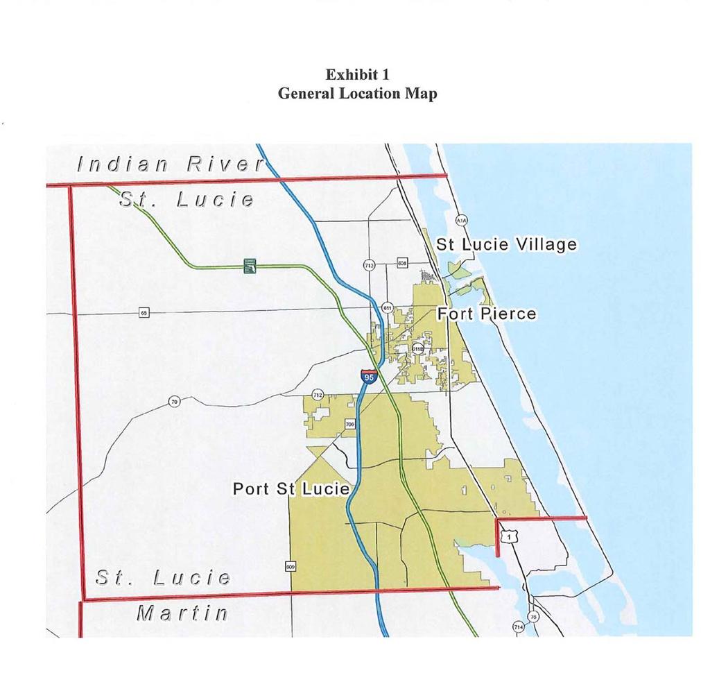
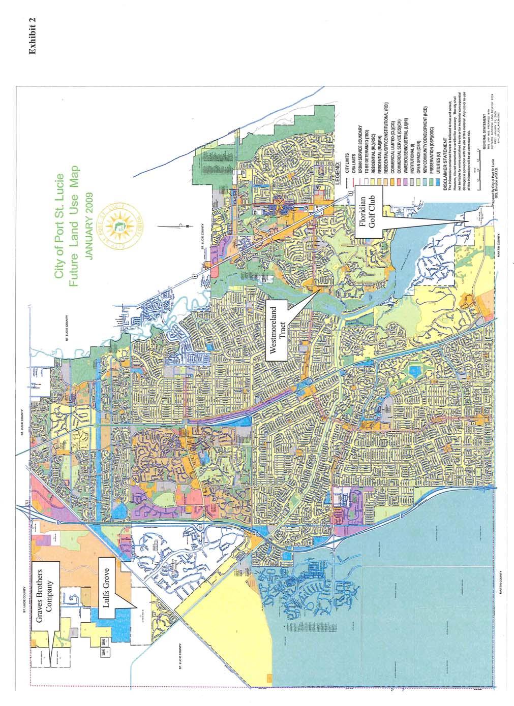
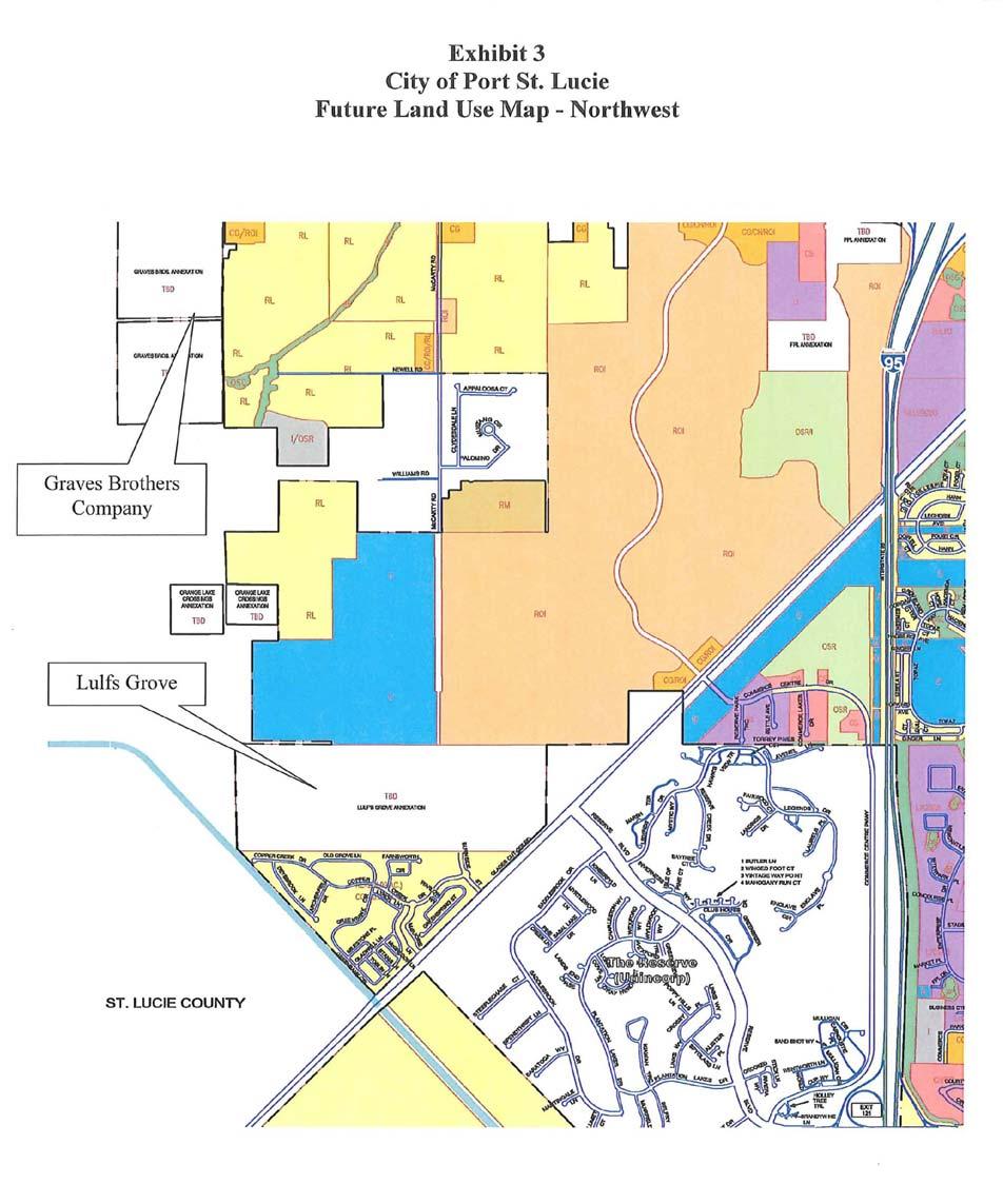
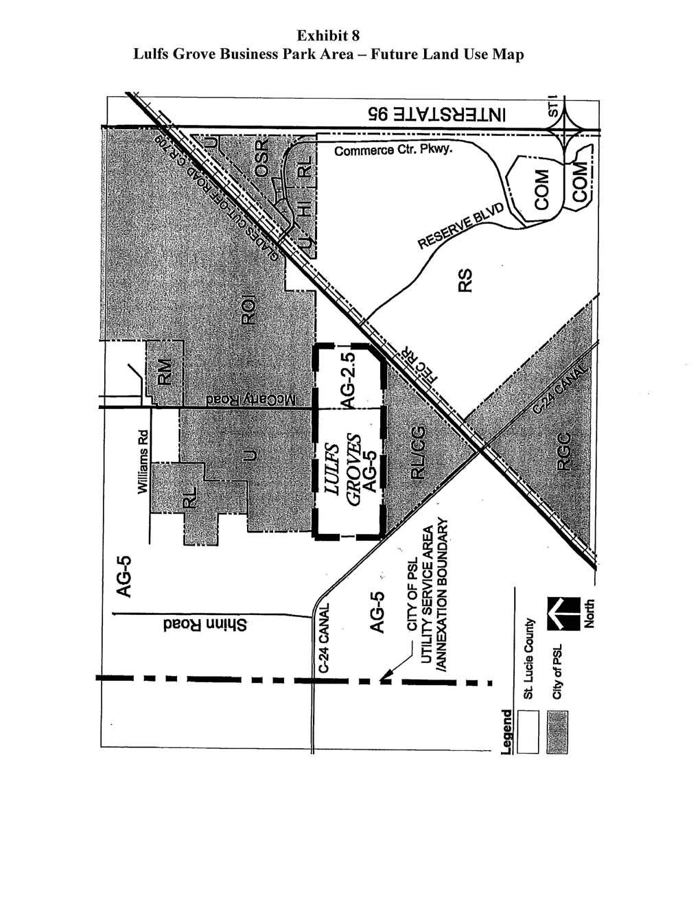
3 Evaluation A. FLUM Amendments The amendments are summarized in Table 1. The location of the subject properties and other information is shown on the attached exhibits. 1. Amendment P (Graves Brothers Company) This acre property is located at the southeast quadrant of the intersection of M idway and Shinn Roads in the City Northwest Annexation Area (see Exhibits 2-4). The property contains remnant citrus groves. No specific development plan has been submitted to the City for the property. The current FLUM designation is Agricultural (AG-5) under the County Comprehensive Plan (see Exhibit 5). The property was annexed by the City on July 28, The proposed FLUM designations are Residential Low Density (263.0 acres), General Commercial (20.0 acres), Institutional (5.0 acres) and Open Space Recreation (15.8 acres) (see Exhibit 6). The existing land use on surrounding properties is cropland to the north, citrus groves, pasture land and a single-family residence to the east, a plant nursery to the south, and citrus groves and a nursery to the west. There is a very small amount of native habitat (less than 4 acres) remaining on site. The proposed amendment is subject to an annexation agreement. The City Planning and Zoning Department recommended approval with seven conditions which have to do with: 1. Funding for improvements to Midway Road. 2. Conveyance of right-of-way for the roadway network and for a fair share of roadway improvements. 3. Limitations on density/intensity. 4. Participation in a Master Stormwater System. 5. The provision of public sewer and water services. 6. Development as a Planned Unit Development (PUD). 7. Preservation of native habitat. The City Local Planning Agency recommended approval unanimously with the conditions recommended by staff. 2. Amendment P (Lulfs Grove) This acre property is located between Glades Cut-Off Road and the C-24 canal, in the City Northwest Annexation Area (see Exhibit 7). The property was annexed by the City on June 6, The land is currently vacant and was 3
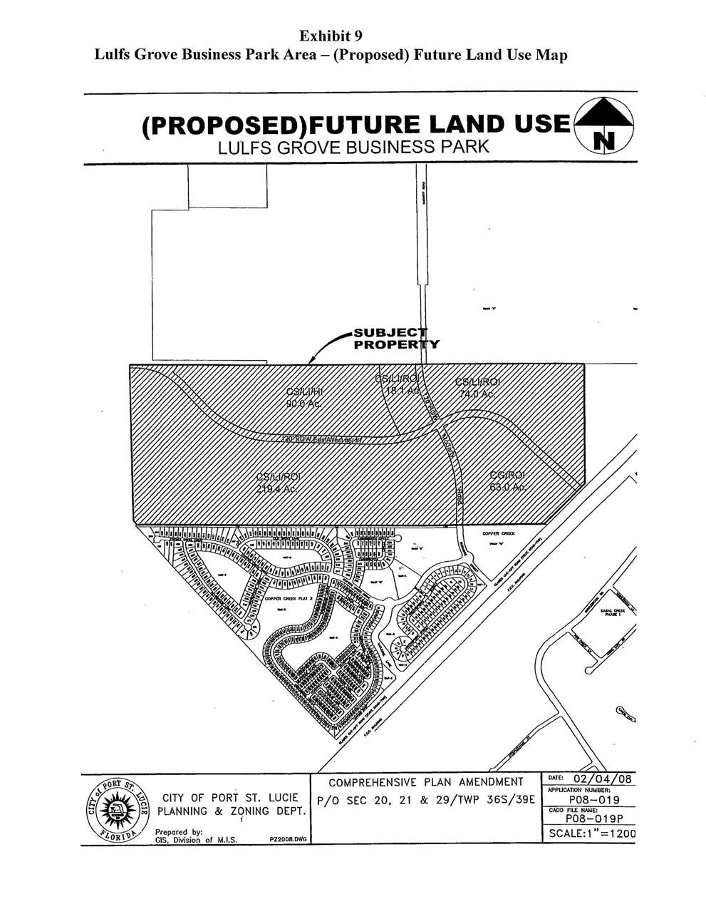
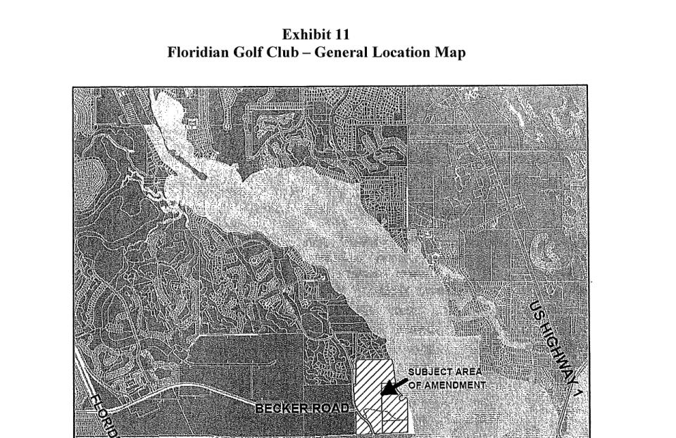
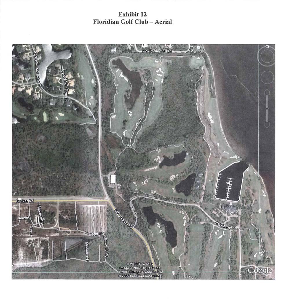
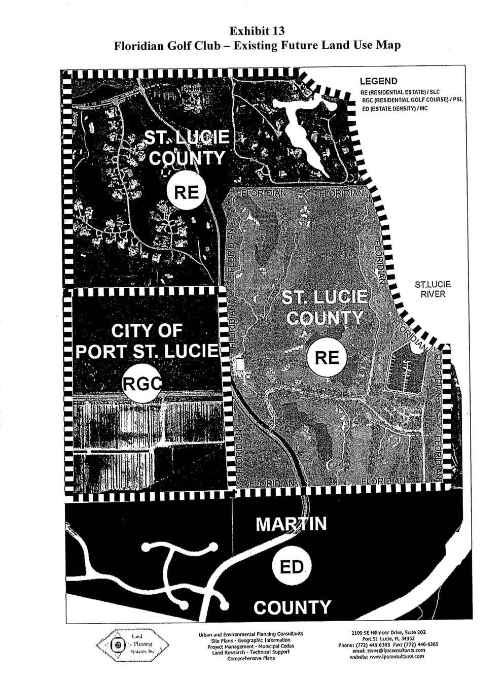
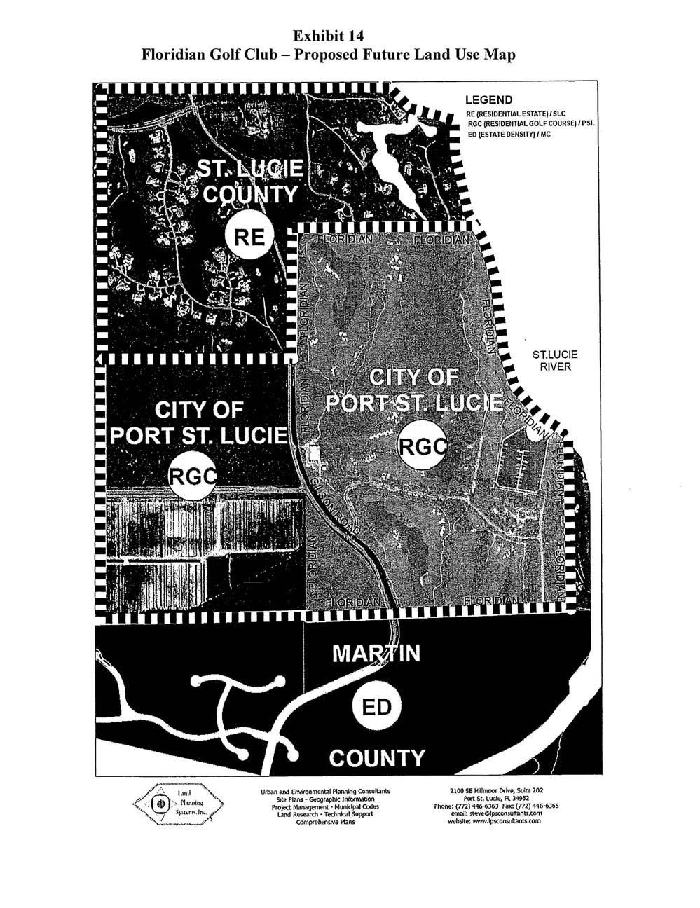
4 formerly used for agricultural purposes. Although no conceptual development plan has been submitted, a mixed-use regional business park is proposed for the site. The current FLUM designations under the County Plan are Agricultural (AG acres; AG acres) (see Exhibit 8). The proposed FLUM designations would allow a mix of commercial, industrial and residential uses (see Table 1 and Exhibits 9, 10). The current land uses on surrounding properties include the City Wastewater Treatment Plant and undeveloped property within the LTC Ranch Development of Regional Impact to the north, agricultural land to the east, a residential/commercial PUD to the south, and agricultural lands to the west. The FLUM designations on surrounding properties are Residential/Office/Industrial and Utility to the north, Residential Suburban and AG-2.5 (St. Lucie County designation) to the east, Residential Low Density and General Commercial to the south and AG 2.5 (St. Lucie County) to the west. The proposed use is a large, mixed-use business and industrial employment area. It would provide a diversity of employment opportunities consistent with the City Economic Development Element. It is to be established in and governed by new comprehensive plan policies in the Future Land Use Element (discussed below). The City staff recommendation of approval was with 10 conditions similar to those in the Graves Brothers Company FLUM amendment listed above. The conditions also contain limitations on total residential and non-residential development. The Local Planning Agency recommended approval unanimously, as conditioned. 3. Amendment P (Floridian Golf Club) This acre property is located east of Gilson Road, north and south of the intersection with Becker Road (see Exhibits 11). It is in the extreme southeastern portion of St. Lucie County and extends to the Martin County line. The Floridian Golf Club property within St. Lucie County was annexed by the City of Port St. Lucie on March 10, The Floridian also includes adjacent acres in Martin County, approved as the Harbor Links Yacht and Country Club in October of The property currently contains part of an 18-hole golf course, a clubhouse, marina and two residential structures (see Exhibit 12). No changes in use are proposed at this time. The current FLUM designation under the County Comprehensive Plan is Residential Estate, maximum one dwelling unit per acre (see Exhibit 13). The proposed FLUM designation under the City Plan is Residential Golf Course, a designation that permits a maximum of 5 dwelling units per acre and one 18-hole golf course per development (see Exhibit 14). The existing land use on surrounding properties is a residential/golf course development to the north, the St. Lucie River and a portion of the Floridian 4
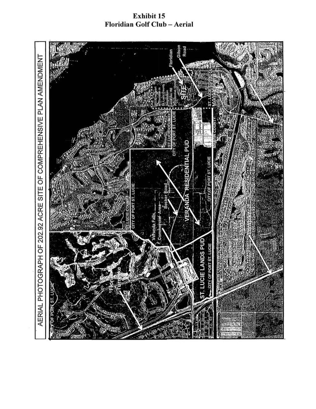
5 property in Martin County to the east, the Floridian Golf Club course to the south, and the Verada PUD and Harbor Ridge development to the west. The FLUM designations on surrounding properties are Residential Estate (St. Lucie County) to the north, Estate Density Residential (Martin County) to the east and south, and Residential Estate (St. Lucie County) and Residential Golf Course to the west. The subject property is adjacent to and under common ownership with the Verada PUD (see Exhibit 15). This PUD was approved by the City for 3,131 residential units in The amendment materials indicate that the City has conditioned the amendment on incorporation of the Floridian property into the Verada PUD. This would allow residential units to be built on the Floridian property, but would permit no increase in the 3,131 units authorized in the Verada PUD. The City Planning and Zoning Department recommended approval on that basis and the Local Planning Agency unanimously recommended approval. 4. Amendment P (Westmoreland Tract) This amendment is for land within two parcels located south of Port St. Lucie Boulevard, between Westmoreland Boulevard and the North Fork of the St. Lucie River (see Exhibits 16). The total size of the parcel is 19.7 acres for Parcel 1 and 12.9 acres for Parcel 2. Both properties are currently vacant. Parcel 1 is to be used for a City botanical garden and Parcel 2 for a passive recreation environmental preserve. The existing FLUM designations of the property subject to amendment are General Commercial and Residential Medium Density. The proposed designations are Open Space Recreational and Open Space Preservation (see Exhibit 17). The current land use on surrounding properties includes a shopping center to the north, single-family homes to the east, a condominium development to the south and the North Fork of the St. Lucie River to the west. The FLUM designations on surrounding lands include General Commercial to the north, Residential Low to the east and Residential Medium to the south. These parcels were purchased in 2002 under the Florida Communities Trust Land Conservation Program. The management plan for the property requires the FLUM designations to be changed to Open Space Recreation and Open Space Preservation. The lands already designated as Open Space Preservation are primarily wetlands. The FLUM designation on these lands will not be modified. B. Text Amendments The proposed text amendments are to the Future Land Use Element. (The proposed policies are shown in entirety in Attachment A). Existing Policy indicates the City shall encourage development to build mixed use projects which integrate several land uses within the same project. New portions of Policy go into more detail regarding the purposes of mixed use areas and that the mixed use area 5
6 shall be established by amendment to the FLUM and by sub-area policies within the Future Land Use Element. New Policy establishes the location for the Lulfs Groves Business Park Area. New Policy contains the types of land uses allowed in Lulfs Groves Business Park Area and the mix of uses/density intensity proposed. Extrajurisdictional Impacts Under the informal agreement facilitated by the Treasure Coast Regional Planning Council (TCRPC), local governments in the northern three counties of the region are to provide copies of amendment materials to other local governments that have expressed an interest in receiving such materials. The City provided copies of the proposed amendment materials to St. Lucie County, the St. Lucie County School Board, Martin County, the Martin Metropolitan Planning Organization, the St. Lucie Transportation Planning Organization and the City of Fort Pierce. Council staff provided a memorandum dated January 27, 2009 to each of these local governments and agencies seeking comments on the proposed amendments. As of the date of the preparation of this report, no comments were received in response to the TCRPC memorandum. Effects on Significant Regional Resources or Facilities Analysis of the proposed amendments indicates that they would not have adverse effects on significant regional resources or facilities. Analysis of Consistency with Strategic Regional Policy Plan In 2003, the City of Port St. Lucie adopted a Western Annexation Area Boundary Map (see Exhibit 18), reflecting additional lands the City intended to annex to provide for long-term growth. The area is based, in part, on a sewer and water service boundary established by agreement between the City and the County. The area is to include a greenbelt buffer along the western boundary of the annexation area to separate urban development from rural uses. The area west of I-95 that has either already been annexed by the City, or is within the Western Annexation Area but has not yet been annexed, would add approximately 42 square miles to the area of the City. When these annexations are completed, the City would contain an area of 120 square miles and be one of the largest cities in the nation. Several large properties in the area were annexed and assigned City FLUM designations in 2003, 2004, and Additional annexations were done in 2008; and amendments are now proposed to assign City FLUM designations to those lands, including Orange Lake Crossings (P08-179); Graves Brothers Company (P06-262); and Lulfs Grove (P08-019). The extent of the City annexations and FLUM amendments in the northern portion of the Western Annexation Area are shown in Table 2. 6
7 Table 2 Annexations and FLUM changes in the northern portion of the City s Western Annexation Area Amendment Round Amendment #1 Name Acreage Old FLUM New FLUM DUPA (potential) 03-1 Northpoint PUD 2,068.0 AG 2.5 ROI, GC, CH, OSR and 4,000* (formerly LTC Ranch DRI) MXD I 04-1 Kenco (Enchantment) AG-5 (154 acres) RL (353 acres) 1,897 AG2.5(232 acres) CG (18 acres) ROI (12 acres) 04-1 Panda 74.1 MXD CS (24.1 acres) LI (50.0 acres) 04-1 Lennar Becker (Copper AG-5 (237 acres) RL (265 acres) 1,325 Creek) AG 2.5 (48 acres) CG (20 acres) 04-2 Glades WWTP AG-5 U 06-1 DJG Development AG-5 RL McCarty Road 71.5 AG 2.5 RM Midway 100 East AG 25 RL (95 acres) 475 CG (5.0 acres) 06-2 West Creek AG-5 RL (363 acres) 2,090 CG/ROI (15 acres) CG/ROI/RL (10 acres) OSR (8 acres) I/OSR (38 acres) OSC (12 acres) 09-1 ** Orange Lake Crossings AG-5(66.06 acres) RL (66.06 acres) 1,166 RL ( acres) RM (63.54 acres) CG (17.70 acres) ROI (12.39 acres) U (9.29 acres) OSR (8.13 acres) 09-2 ** Graves Brothers Company AG-5 RL (263.0 acres) CG (20.0 acres) I (5 acres) OSR (15.8 acres) 1, ** Lulfs Grove AG-5 (304.0 acres) AG-2.5 (160.5 acres) CS/LI/HI (90 acres) CS/LI/ROI (311.5 acres) CG/ROI (63.0 acres) 500*** TOTAL 4, ,485 * Maximum number of dwelling units per Development of Regional Impact. ** Proposed *** Limited to 500 units by Comprehensive Plan Policy 7
8 Council has previously expressed a number of concerns and made a number of recommendations to the City as lands within the Western Annexation Area were annexed and assigned City FLUM designations. Excerpts from previous Council reports from 2003, 2004 and 2006 are included in Attachment A. Council urged the City to prepare a master plan and urban design study for the Northwestern Annexation Area. This was considered especially important because of the large number of landowners in the area. Council emphasized the need for a well planned network for public infrastructure, including roads, stormwater management, schools and parks. Council also recommended the City prepare a long-range fiscal impact analysis and financing plan that would help ensure the financial feasibility of development in the area. The City has taken some steps to ensure the Northwest Annexation Area is well planned. A Proposed Roadway Grid Network Map was adopted (see Exhibits 19, 20). A master stormwater management plan is proposed. Some school and park sites have been identified. However the City did not adopt an overall master plan for the area that could guide future development. As each landowner seeks annexation and FLUM designation approval, the City must consider the merits of each proposal without the benefit of a conceptual plan for the entire area that would enable the City to assess whether the appropriate range and mix of uses is being proposed that would allow the area to become an important and integral part of the City. Indeed, this area already has the potential based on what designations have been assigned to become one of the largest communities in the region on its own. The SRPP anticipates that new development will be done in the form of neighborhoods and districts that contain a balanced, well-planned compatible mix of land uses with compact designs and a mix of building types. It will be a challenge for the City to ensure this new part of the City will be built in a sustainable manner, with a good network of streets, provisions for bicycle and pedestrian use and public transit, adequate recreational facilities, public facilities and infrastructure including civic sites, employment opportunities and a variety of housing types, sizes and affordabilities. Comments/Recommendations FLUM Amendments A. Graves Brothers Company (P06-262) 1. Map A1 of the City Transportation Element is the Western Study Area Roadway Network Plan (Exhibit 19). This Plan may need to be modified as necessary, to accommodate the City vision for this area. Based on the Conceptual Master Plan provided with the application materials for Amendment P06-262, the proposed roadway referenced as East/West #5 (or Newell Road on the City Right-of-Way Network Map see Exhibit 21), would not continue through the subject property and connect with Shinn Road. This east/west corridor is a very important component of the roadway network. The City should ensure that the integrity and density of the major 8
9 roadway network through the area is maintained. As development is proposed, the City should also ensure that the local street network is not only adequate, but fully connects with the larger roadway network. There should be no significant disruptions to the network, such as large, gated development. 2. The proposed amendment shows 15.8 acres to be designated as Open Space Recreation. The recreational acreage is required in order to meet the City s established recreation level of service. However, there is no indication at this time that the land is to be dedicated to the City for park land or that the recreation area is to be connected to lands that are to be reserved for recreational use on adjacent properties (including the West Creek property to the immediate east). It is important that such areas be connected when feasible so that the City can establish a network of greenways, pedestrian trails, bicycle trails, etc. 3. During the review of previous amendments for the Western Annexation Area, the City indicated that staff was developing a workforce housing program. Council recommended that no more density increases be assigned until the City adopted and implemented such a program. The City has yet to prepare and adopt a workforce housing program. However, the City did establish an Affordable Housing Committee which prepared a report with findings and recommendations that were presented to the City on December 8, The City has not yet taken action on these recommendations. This amendment would designate 263 acres for low density residential development. The City has already designated hundreds of acres in this area for low density residential development (see Table 2). It is important that this property and all others in the area contain a mix of housing types and sizes. It would be more appropriate if some medium and high density residential development be built on this property, perhaps as a transition between the commercial uses and the lower density residential uses. Only with a variety of housing types, sizes and prices will the City achieve the mix of housing necessary to meet the needs of the workforce that would reside in this area. The City should require a range of housing types and affordabilities for both owner and renter households in all new development in the Western Annexation Area consistent with Regional Goal 2.2. B. Lulfs Grove (P08-019) 1. The FLUM amendment materials show that both McCarty Road and East/West Road #6 would run through this property when developed. As indicated above, it is very important that the City ensure the proposed roadway network through the Northwest Annexation Area includes adequate east/west and north/south interconnections to the larger roadway network of the area (Glades Cut-Off Road, Midway Road, Rangeline Road). 9
10 2. The City of Port St. Lucie has not established any Mixed Use FLUM designations in the comprehensive plan; although Policy of the Future Land Use Element indicates the City shall encourage developers to build mixed-use projects which integrate several land uses. However, the absence of mixed use FLUM designations makes the implementation of this policy unwieldy; requiring several existing FLUM designations to be applied to different portions of a property (see Exhibits 9, 10 for an example of this as it pertains to the Lulfs Grove amendment). In this case, the City is considering additional comprehensive plan text policies to better define the mix of uses. The City is encouraged to adopt one or more Mixed Use FLUM designations, where the parameters for the intensity and density of the various uses would be set forth. 3. Council has been copied with a letter from a representative of the PGA Village Association, Inc. (see Attachment C). The PGA Village development (formerly known as the Reserve DRI) is located within unincorporated St. Lucie County, across Glades Cut-Off Road from the Lulfs Grove property. The letter expresses a number of concerns regarding the amendment and mix of development that is proposed for the Lulfs Grove property and questions the consistency of the proposed amendment with state statutes and administrative code. The City should meet with the adjoining property owner and attempt to resolve concerns regarding compatibility and buffering. Text Amendments 1. Proposed Policy sets forth the mix of land uses for the Lulfs Grove Business Park (see Attachment A). However, the policy fails to define the extent of each allowable use. Included under section (b.) of the policy is a proposed distribution of uses and intensities. The policy should instead define the maximum (and minimum if considered appropriate by the City) amount of development that would be permitted and/or the minimum and maximum percentage for each use. Consistency with Strategic Regional Policy Plan The contract agreement between the DCA and the Treasure Coast Regional Planning Council requires Council to include a determination of consistency with the SRPP as part of the written report to be submitted to the DCA. Council finds the proposed amendments to be CONSISTENT with the SRPP. The City is strongly encouraged to consider the comments and recommendations made by the Council. Decisions made today to assign development rights and designations to vacant land in the Northwest Annexation Area are critically important to the future of the City. The mix and intensity of uses, the variety and affordability of housing and the adequacy of planned infrastructure including the roadway and street network are of utmost importance. 10
11 Recommendation Council should adopt the above comments and instruct staff to transmit the report to the Department of Community Affairs. Attachments 11
12 12
13 13
14 14
15 15
16 16
17 17
18 18
19 19
20 20
21 21
22 22

23 23
24 24
25 25
26 26
27 27
28 28
29 29
30 30
31 31
32 32
33 33
34 34
35 35
36 36
37 37
38 38
39 39
40 40
41 41
42 42
43 43
44 44
45 45
46 46
47 47
48 48
49 49
50 50
51 51
52 52
53 53
54 54
55 55
TREASURE COAST REGIONAL PLANNING COUNCIL M E M O R A N D U M. February 19, 2010 Regional Planning Council Meeting
 TREASURE COAST REGIONAL PLANNING COUNCIL M E M O R A N D U M To: Council Members AGENDA ITEM 5H From: Date: Subject: Staff February 19, 2010 Regional Planning Council Meeting Local Government Comprehensive
TREASURE COAST REGIONAL PLANNING COUNCIL M E M O R A N D U M. To: Council Members AGENDA ITEM 4B15
 TREASURE COAST REGIONAL PLANNING COUNCIL M E M O R A N D U M To: Council Members AGENDA ITEM 4B15 From: Date: Subject: Staff May 18, 2018 Council Meeting Local Government Comprehensive Plan Review Draft
TREASURE COAST REGIONAL PLANNING COUNCIL M E M O R A N D U M. To: Council Members AGENDA ITEM 5H
 TREASURE COAST REGIONAL PLANNING COUNCIL M E M O R A N D U M To: Council Members AGENDA ITEM 5H From: Date: Subject: Staff October 17, 2008 Council Meeting Local Government Comprehensive Plan Review Draft
TREASURE COAST REGIONAL PLANNING COUNCIL M E M O R A N D U M. To: Council Members AGENDA ITEM 5I
 TREASURE COAST REGIONAL PLANNING COUNCIL M E M O R A N D U M To: Council Members AGENDA ITEM 5I From: Date: Subject: Staff December 12, 2008 Council Meeting Local Government Comprehensive Plan Review Town
MEMORANDUM AGENDA ITEM #6c
 South Florida Regional Planning Council MEMORANDUM AGENDA ITEM #6c DATE: FEBRUARY 1, 2010 TO: FROM: SUBJECT: COUNCIL MEMBERS STAFF CITY OF PARKLAND PROPOSED COMPREHENSIVE PLAN AMENDMENT (ALTERNATIVE REVIEW)
DRAFT Subject to Modifications
 DRAFT Subject to Modifications TREASURE COAST REGIONAL PLANNING COUNCIL M E M O R A N D U M To: Council Members AGENDA ITEM 7C8 From: Date: Subject: Staff January 20, 2017 Council Meeting Local Government
Baumgarten MPUD. Exhibit 3 Evaluation Criteria
 Pursuant to LDC subsections 10.02.13 B, 10.02.08 F and Chapter 3 G. of the Administrative Code, staff s analysis and recommendation to the Planning Commission, and the Planning Commission s recommendation
DRAFT Subject to Modifications
 DRAFT Subject to Modifications TREASURE COAST REGIONAL PLANNING COUNCIL M E M O R A N D U M To: Council Members AGENDA ITEM 7C10 From: Date: Subject: Staff January 20, 2017 Council Meeting Local Government
TREASURE COAST REGIONAL PLANNING COUNCIL M E M O R A N D U M. To: Council Members AGENDA ITEM 8B5
 TREASURE COAST REGIONAL PLANNING COUNCIL M E M O R A N D U M To: Council Members AGENDA ITEM 8B5 From: Date: Subject: Staff February 17, 2017 Council Meeting Local Government Comprehensive Plan Review
CHARLES PUTMAN CHARLES PUTMAN AND ASSOCIATES, INC
 MEMORANDUM CHARLES PUTMAN & ASSOCIATES, INC. LAND DEVELOPMENT CONSULTANTS PLANNING ZONING PERMITTING 4722 NW Boca Raton Boulevard, Suite C-106 Boca Raton, Florida 33431 Phone: 561/994-6411 FAX: 561/994-0447
RECREATION AND OPEN SPACE ELEMENT GOALS, OBJECTIVES, AND POLICIES
 RECREATION AND OPEN SPACE ELEMENT GOALS, OBJECTIVES, AND POLICIES Goal 7 To provide park facilities, recreation programs, and open space resources that are safe, adequate, and accessible to all City residents,
Osceola County Board of County Commissioners 1 Courthouse Square, Suite 1100 Kissimmee, FL
 1/10/11 Item Number DRI08-0006 Osceola County Board of County Commissioners 1 Courthouse Square, Suite 1100 Kissimmee, FL 34741 407-742-0200 Applicant & Owner Center Lake Properties, LLLP and Formally
Dwelling Units Max 12 dwelling units per acre/min 8 dwelling units per acre. Development Mix 80% non residential/20% residential
 13. OSTEEN LOCAL PLAN Background: The Osteen Local Plan area is located in southwest Volusia County along the SR 415 corridor between Lemon Bluff Road and Acorn Lake Road and includes 3,990 acres. The
TREASURE COAST REGIONAL PLANNING COUNCIL M E M O R A N D U M. To: Council Members AGENDA ITEM 4B3
 Revision: 3-15-19 TREASURE COAST REGIONAL PLANNING COUNCIL M E M O R A N D U M To: Council Members AGENDA ITEM 4B3 From: Staff Date: March 8, 2019 Subject: Local Government Comprehensive Plan Review Draft
SUBJECT: LOCAL GOVERNMENT COMPREHENSIVE PLAN PROPOSED AND ADOPTED AMENDMENT CONSENT AGENDA
 MEMORANDUM AGENDA ITEM #IV.C DATE: APRIL 15, 2019 TO: FROM: COUNCIL MEMBERS STAFF SUBJECT: LOCAL GOVERNMENT COMPREHENSIVE PLAN PROPOSED AND ADOPTED AMENDMENT CONSENT AGENDA Pursuant to the 1974 Interlocal
TREASURE COAST REGIONAL PLANNING COUNCIL M E M O R A N D U M. To: Council Members AGENDA ITEM 3I
 TREASURE COAST REGIONAL PLANNING COUNCIL M E M O R A N D U M To: Council Members AGENDA ITEM 3I From: Date: Subject: Staff December 8, 2017 Council Meeting Local Government Comprehensive Plan Review Draft
MEMORANDUM AGENDA ITEM #IV.C
 MEMORANDUM AGENDA ITEM #IV.C DATE: NOVEMBER 27, 2017 TO: FROM: COUNCIL MEMBERS STAFF SUBJECT: LOCAL GOVERNMENT COMPREHENSIVE PLAN PROPOSED AND ADOPTED AMENDMENT CONSENT AGENDA Pursuant to Section 163.3184,
DRAFT Subject to Modifications
 TREASURE COAST REGIONAL PLANNING COUNCIL M E M O R A N D U M DRAFT Subject to Modifications To: Council Members AGENDA ITEM 5F From: Date: Subject: Staff September 17, 2010 Council Meeting Local Government
This page intentionally blank.
 This page intentionally blank. Parks, Recreation, and Open Space Chapter Relationship to Vision Vision Parks, Recreation and Open Space Chapter Concepts County Government. County government that is accountable
Micco Park Village Development
 FOR SALE Call For Pricing Micco Park Village Development Proposed Project Property Details Micco Park Village Development PRICE Call For Pricing A monumental development opportunity of a lifetime! The
DRAFT Subject to Modifications TREASURE COAST REGIONAL PLANNING COUNCIL
 DRAFT Subject to Modifications TREASURE COAST REGIONAL PLANNING COUNCIL M E M O R A N D U M To: Council Members AGENDA ITEM 7C From: Date: Subject: Staff June 22, 2007 Council Meeting Local Government
AWH REPORT OF THE PLANNING AND DEVELOPMENT DEPARTMENT FOR APPLICATION FOR REZONING ORDINANCE TO PLANNED UNIT DEVELOPMENT
 AWH REPORT OF THE PLANNING AND DEVELOPMENT DEPARTMENT FOR APPLICATION FOR REZONING ORDINANCE TO PLANNED UNIT DEVELOPMENT MAY 8, 2014 The Planning and Development Department hereby forwards to the Planning
General Location Annex, Rezone & Preliminary Plat Lansdowne Addition, Unit Three
 NEWFOUNDLAND I-5 Agricultural District Subject Site SUNDANCE ANDERSON Single Family Residential CHRISTY PUD Agricultural District Highway Business General Location Annex, Rezone & Preliminary Plat Lansdowne
3.10 LAND USE SETTING PROJECT SITE EXISTING LAND USE DESIGNATIONS AND ZONING. General Plan Land Use Designations.
 This section of the Draft EIR addresses the existing land uses on and adjacent to the project site and discusses the potential impacts of the proposed project on existing land uses. Key issues addressed
INTERGOVERNMENTAL COORDINATION ELEMENT
 Goals, Objectives and Policies COORDINATION ELEMENT GOAL 8.1.: ESTABLISH EFFECTIVE COORDINATION MEASURES AMONG ALL PERTINENT PUBLIC AND QUASI-PUBLIC ENTITIES SO TO BEST MAINTAIN PALM BEACH GARDENS' QUALITY
DRAFT Subject to Modifications
 DRAFT Subject to Modifications TREASURE COAST REGIONAL PLANNING COUNCIL M E M O R A N D U M To: Council Members AGENDA ITEM 10 From: Date: Subject: Staff February 19, 2016 Council Meeting Local Government
Natomas Vision Plan and PLNP
 Natomas Vision Plan 20030171 and PLNP2014-00172 Department of Community Development Planning and Environmental Review Leighann Moffitt Sub-Agenda 1. Staff Presentation Leighann Moffitt, County Planning
FUTURE LAND USE ELEMENT
 FUTURE LAND USE ELEMENT INTRODUCTION The Future Land Use Element designates the proposed future general distribution, location, and extent of the uses of land for residential uses, commercial uses, industry,
Goal 1: To Encourage the Orderly, Harmonious and Judicious Use of University Resources in the Development of University Land.
 2.0 Future Land Use Goal 1: To Encourage the Orderly, Harmonious and Judicious Use of University Resources in the Development of University Land. Objective 1.1: Make available future building sites that
CHUGIAK-EAGLE RIVER SITE-SPECIFIC LAND USE PLAN
 CHUGIAK-EAGLE RIVER SITE-SPECIFIC LAND USE PLAN JUNE 2010 Final Prepared for The Heritage Land Bank, Municipality of Anchorage by Agnew: :Beck Consulting www.agnewbeck.com 907.222.5424 Chugiak-Eagle River
Description of Preferred Alternative
 Chapter 2 Description of Preferred Alternative 2.1 Introduction This chapter of the programmatic Sammamish Town Center Sub-area Plan Final EIS provides a more detailed description of the Preferred Alternative
14. INTERGOVERNMENTAL COORDINATION ELEMENT
 14. Introduction This Intergovernmental Coordination Element includes Goals, Objectives and Policies (GOP) that apply to the main campus and Alachua County Satellite Properties. The Intergovernmental Coordination
Staff Report to the North Ogden City Planning Commission
 Staff Report to the North Ogden City Planning Commission SYNOPSIS / APPLICATION INFORMATION Application Request: Concept review on a legislative application to rezone land located at approximately 1750
PLANNING COMMISSION. Agenda Item # 3.
 PLANNING COMMISSION Agenda Item # 3. CASE SUMMARY Conditional District Rezoning Planning Commission February 4, 2015 CD-9-215 Jeff Walton, 341-3260, jeff.walton@wilmingtonnc.gov Staff recommendation CONDITIONAL
This chapter describes the purpose of the Plan, introduces how the Plan is organized and provides contextual background for the Plan.
 Chapter 1: INTRODUCTION Purpose of a Comprehensive Plan The 2040 Comprehensive Plan establishes Medina s vision as a community and sets goals and objectives which guide future decisions and policies. The
COLVER ROAD INDUSTRIAL CONCEPT PLAN
 COLVER ROAD INDUSTRIAL CONCEPT PLAN A CONCEPTUAL LAND USE AND TRANSPORTATION PLAN FOR TA-4 AN URBAN RESERVE AREA OF THE CITY TALENT City of Talent Adopted by City Council Resolution No., June, 2015 PART
Department of Community Development. Planning and Environmental Review Division Revised Notice of Preparation
 Department of Community Development Michael J. Penrose, Acting Director Divisions Building Permits & Inspection Code Enforcement County Engineering Economic Development & Marketing Planning & Environmental
Citizen Comment Staff Response Staff Recommended Revision Planning Committee
 Citizen Comment Staff Response Staff Recommended Revision Planning Committee Area No. 1: Owner desires retail land uses. Area No. 1a: Owner of two small parcels adjacent to Area No. 1 desires retail land
Ten Mile Creek Planning Area
 PLANNING AREA POLICIES TEN MILE CREEK Ten Mile Creek Planning Area Location and Context The Ten Mile Creek Planning Area ( Ten Mile Creek area ) is located south of the current Boise AOCI, generally south
 PROJECT NARRATIVE AVENIR PCD SITE PLAN #2 SITE PLAN REVIEW March 14, 2018 Request Avenir Holdings, LLC, the owner of the approved Avenir Planned Urban Planning and Design Landscape Architecture Communication
ARTICLE 6: Special and Planned Development Districts
 ARTICLE 6: Special and Planned Development Districts 6-10 Traditional Neighborhood Development (TND) District 6-10.10 Purpose and Intent The Traditional Neighborhood Development (TND) District provides
Regional Context Statement
 Regional Context Statement REGIONAL CONTEXT STATEMENT 3. REGIONAL CONTEXT STATEMENT In 1995, the Provincial Government passed into law the Growth Strategies Act. The purpose of this provincial initiative
Vision Statement for the Town of Flower Mound Master Plan The Town of Flower Mound Master Plan furthers the established community based vision to:
 Vision Statement for the The furthers the established community based vision to: Preserve the country atmosphere and natural environment that makes Flower Mound a unique and desirable community; Mitigate
EAST LAKE TARPON COMMUNITY OVERLAY
 EAST LAKE TARPON COMMUNITY OVERLAY East Lake Tarpon in Pinellas County Florida physical area is defined by the boundaries of the as shown in the map below and legal description in Appendix A. VISION: East
CONSENT CALENDAR CITY PLANNING COMMISSION AGENDA ITEM NO: A.1, A.2 STAFF: LARRY LARSEN
 Page 8 CONSENT CALENDAR CITY PLANNING COMMISSION AGENDA ITEM NO: A.1, A.2 STAFF: LARRY LARSEN FILE NO: CPC PUZ 14-00013 - QUASI-JUDICIAL FILE NO: CPC PUD 14-00014 QUASI-JUDICIAL PROJECT: APPLICANT: OWNER:
Future Land Use and Transportation
 Planning & Zoning Board Workshop Comprehensive Plan for Village of Estero Future Land Use and Transportation April 6, 2017 January Kick-off Meeting Public Input What do you like about Estero? Location
Urban Development Areas Frederick County
 18 Urban Development Areas Frederick County UDA Needs Profile: All UDAs Frederick County, Virginia's northernmost county has two UDA s, surrounded by the City of Winchester and located adjacent to the
Chapter 10 IMPLEMENTATION RECOMMENDATIONS
 Chapter 10 IMPLEMENTATION RECOMMENDATIONS The recommended land use plan presented in the previous chapter provides a design for the attainment of the urban and rural development and open space preservation
DEVELOPMENT FRAMEWORK POST 2030 LAND USE PLAN INTRODUCTION
 INTRODUCTION Oak Grove s Comprehensive Plan identifies a future Metropolitan Urban Service Area (MUSA). The Metropolitan Council does not anticipate extending utilities to this area prior to 2030. The
#3) DA AMENDMENT TO DEVELOPMENT AGREEMENT PARK HIGHLANDS - WEST PUBLIC HEARING
 DA AMENDMENT TO DEVELOPMENT AGREEMENT PARK HIGHLANDS - WEST PUBLIC HEARING") #3) DA-03-16 AMENDMENT TO DEVELOPMENT AGREEMENT PARK HIGHLANDS - WEST PUBLIC HEARING STAFF REPORT To: Planning Commission Meeting date: May 11, 2016 Item: DA-03-16 Prepared by: Robert Eastman GENERAL INFORMATION:
#3) DA-03-16 AMENDMENT TO DEVELOPMENT AGREEMENT PARK HIGHLANDS - WEST PUBLIC HEARING STAFF REPORT To: Planning Commission Meeting date: May 11, 2016 Item: DA-03-16 Prepared by: Robert Eastman GENERAL INFORMATION:
Intergovermental Coordination
 Intergovermental Coordination CITY OF WINTER PARK CHAPTER 8: INTERGOVERNMENTAL COORDINATION ELEMENT INTERGOVERNMENTAL COORDINATION ELEMENT GOAL 8-1: PROVIDE FOR IMPROVED INTERGOVERNMENTAL COORDINATION
LAND USE MEADOWS PLANNING AREA
 LAND USE MEADOWS PLANNING AREA I. Profile of Meadows Planning Area A. Location Meadows Planning Area is delineated by I-5 on the north, the Nisqually Bluffs representing the growth boundary on the east,
Land Use element LAND USE POLICY AREAS ESTATE AND RURAL RESIDENTIAL AREAS/RURAL SHELDON AREA OLD TOWN ELK GROVE
 Land Use element Land Use is often considered the heart of the General Plan. The statement of future land uses describes how the City believes it should develop in the future where housing, shopping, open
LAND USE AMENDMENT CORNERSTONE (WARD 3) 60 STREET NE AND COUNTRY HILLS BOULEVARD NE MAP 26NE BYLAW 22D2017
 60 STREET NE AND COUNTRY HILLS BOULEVARD NE MAP 26NE BYLAW 22D2017") Page 1 of 14 EXECUTIVE SUMMARY This Land Use Amendment application covers an area of 43.76 hectares ± (108.14 acres ±) located in northeast Calgary, bound by Country Hills Boulevard NE to the south and
Page 1 of 14 EXECUTIVE SUMMARY This Land Use Amendment application covers an area of 43.76 hectares ± (108.14 acres ±) located in northeast Calgary, bound by Country Hills Boulevard NE to the south and
Asbury Chapel Subdivision Sketch Plan
 Asbury Chapel Subdivision Sketch Plan PART 1: PROJECT SUMMARY Applicant: NVR Inc. Project Size: +/- 76.13 acres Parcel Numbers: 02101112,02116101,02116112, 02116113 Current Zoning: Transitional Residential
Warren County/Bowling Green Focus 2030 Comprehensive Plan VOLUME 1 INDEX
 Appendix 5: Index VOLUME 1 INDEX A Aesthetics ES-6, FLU-15, FLU-17, FLU-24, NCR-7 Agricultural Base FLU-18, FLU-20 Agricultural Centers, Rural FLU-11 Agricultural District NCR-17-NCR-18 Agricultural Economy
BROOKHILL NEIGHBORHOOD MODEL ZONING MAP AMENDMENT PREFACE TO APPLICATION
 BROOKHILL NEIGHBORHOOD MODEL ZONING MAP AMENDMENT PREFACE TO APPLICATION June 15, 2015 Revised: August 1, 2016 I. VISION Brookhill is a proposed community based upon the principles of Albemarle County
HAZARD MITIGATION GOALS AND OBJECTIVES
 SEWRPC Community Assistance Planning Report No. 282, 2nd Edition CITY OF MILWAUKEE ALL HAZARDS MITIGATION PLAN UPDATE Chapter IV HAZARD MITIGATION GOALS AND OBJECTIVES [NOTE: Throughout this plan update
CITY OF TARPON SPRINGS DCA#11-1AR
 Agenda Item #3.H.2 05/09/11 TAMPA BAY REGIONAL PLANNING COUNCIL LOCAL GOVERNMENT COMPREHENSIVE PLAN ADOPTED AMENDMENT REPORT CITY OF TARPON SPRINGS DCA#11-1AR 1 ADOPTED WITH THE FOLLOWING CHANGES: Ordinance
INTERGOVERNMENTAL COORDINATION ELEMENT Inventory Analysis
 INTERGOVERNMENTAL COORDINATION ELEMENT Inventory Analysis 2.176 INTRODUCTION This Element outlines and analyzes those issues that require intergovernmental cooperation to achieve plan implementation. The
The transportation system in a community is an
 7 TRANSPORTATION The transportation system in a community is an important factor contributing to the quality of life of the residents. Without a sound transportation system to bring both goods and patrons
1934 Commerce Lane Suite 1 Jupiter, Florida Ph Fax Lic # LC-C ATTACHMENT G.
 Landscape Architects I Land Planners I Environmental Consultants 1934 Commerce Lane Suite 1 Jupiter, Florida 33458 Ph 561.747.6336 Fax 561.747.1377 www.cotleurhearing.com Lic # LC-C000239 ATTACHMENT G
[THIS PAGE INTENTIONALLY LEFT BLANK]
![[THIS PAGE INTENTIONALLY LEFT BLANK]](/thumbs/77/76526040.jpg "[THIS PAGE INTENTIONALLY LEFT BLANK]") 1-1 LAND USE [THIS PAGE INTENTIONALLY LEFT BLANK] TABLE OF CONTENTS INTRODUCTION... 7 1-1. GOAL: TO DEVELOP AND MAINTAIN A WELL-BALANCED COMMUNITY WITH A VARIETY OF LAND USES THAT ARE COMPATIBLE WITH EACH
1-1 LAND USE [THIS PAGE INTENTIONALLY LEFT BLANK] TABLE OF CONTENTS INTRODUCTION... 7 1-1. GOAL: TO DEVELOP AND MAINTAIN A WELL-BALANCED COMMUNITY WITH A VARIETY OF LAND USES THAT ARE COMPATIBLE WITH EACH
AREASTRUCTURE PLAN AMENDMENT COCHRANE NORTH
 AREASTRUCTURE PLAN AMENDMENT COCHRANE NORTH In order to implement the vision outlined in the Conceptual Scheme, the following three amendments to the Cochrane North ASP are proposed: 1. Allow commercial
Gold Line Bus Rapid Transit Transit Oriented Development (BRTOD) Helmo Station Area Plan
 Helmo Station Area Plan") Appendix F Gold Line Bus Rapid Transit Transit Oriented Development (BRTOD) Helmo Station Area Plan Introduction and Purpose of the Plan The Gold Line Bus Rapid Transit facility is an eleven-mile dedicated
Appendix F Gold Line Bus Rapid Transit Transit Oriented Development (BRTOD) Helmo Station Area Plan Introduction and Purpose of the Plan The Gold Line Bus Rapid Transit facility is an eleven-mile dedicated
Elm Fork Land Use. Trinity River Corridor Project Committee May 13, 2013
 Elm Fork Land Use Trinity River Corridor Project Committee May 13, 2013 Purpose Discuss Trinity River planned Land Use and Appropriate Compatible Uses, particularly with respect to the Elm Fork Area 2
REQUEST FOR COUNCIL ACTION 6A AGENDA ITEM
 DATE REQUEST FOR COUNCIL ACTION 6A AGENDA ITEM ORIGINATING DEPT. AGENDA ITEM CITY ADMINISTRATOR APPROVAL Community Development PUD Concept & Development Stage Plan Preliminary Plat & Final Plat PREVIOUS
TRANSPORTATION ELEMENT GOALS, OBJECTIVES, AND POLICIES
 TRANSPORTATION ELEMENT GOALS, OBJECTIVES, AND POLICIES GOAL 2 The City shall provide a safe, convenient, effective, and energy efficient multimodal transportation system which is coordinated with the Future
Exhibit A Comprehensive Plan Amendments
 Exhibit A Comprehensive Plan Amendments May 2010 Draft Chapter One - Introduction Chapter One INTRODUCTION NOTE: For brevity and ease in viewing the proposed changes, portions of chapter one that are not
Chapter 5: Natural Resources and Environment
 NATURAL RESOURCES AND ENVIRONMENT 5-1 5 Chapter 5: Natural Resources and Environment BACKGROUND AND INTENT Urban expansion represents the greatest risk for the future degradation of existing natural areas,
COMMISSION ACTION FORM
 ITEM #: 6 DATE: 09-06-17 COMMISSION ACTION FORM REQUEST: Introduction and Initial Review of Proposed Amendments to the Ames Urban Fringe Future Land Map for the North Growth Gap Area BACKGROUND INFORMATION:
DRAFT MAP AMENDMENT FLU 04-4
 DRAFT MAP AMENDMENT FLU 04-4 SW 24 TH AVENUE ROADWAY CORRIDOR The University of Florida participates with the Metropolitan Transportation Planning Organization (MTPO) in its responsibilities for the continuing,
City Center Neighborhood Plan
 [1] City Center Neighborhood Plan As adopted by Ordinance No. 2014-09-049 and amended by Ordinance Nos. Formerly CBD Neighborhood as adopted by Ordinance No. 8868 and amended by Ordinance Nos. 8946, 9693,
open public hearing and allow public comment request to continue LPA public hearing to January 16, 2014 at 10:30 am
 TODAY S AGENDA Work Session LPA Transmittal Public Hearing open public hearing and allow public comment request to continue LPA public hearing to January 16, 2014 at 10:30 am staff will issue a recommendation
DISCUSSION ON VACAVILLE S2 INVESTORS PROPERTY IN URBAN RESERVE
 Agenda Item No. 9C April 25, 2017 TO: FROM: SUBJECT: Honorable Mayor and City Council Attention: Jeremy Craig, Interim City Manager Barton Brierley, AICP, Community Development Director (Staff Contact:
Right-of-Way Acquisitions and Relocations Technical Memorandum
 Right-of-Way Acquisitions and Relocations Technical Memorandum Southeast Extension Project Lincoln Station to RidgeGate Parkway Prepared for: Federal Transit Administration Prepared by: Denver Regional
CITY OF PUYALLUP. Background. Development Services
 CITY OF PUYALLUP Development Services 333 South Meridian Puyallup WA 98371 To: City Council From: Katie Baker, AICP, Planning Division Re: South Hill Neighborhood Plan Adoption Date: (Meeting date: February
Colchester Growth Management Strategy. Open House Meeting October 1, 2015
 Colchester Growth Management Strategy Open House Meeting October 1, 2015 6:00 View panels and meet the consultant team 6:30 Presentation and Q&A 7:30 Informal discussion and fill out comment sheets The
Review of Opportunity Area C Draft Comprehensive Plan and Draft BOS Follow-On Motions. Special Working Group Meeting March 4, 2015
 Review of Opportunity Area C Draft Comprehensive Plan and Draft BOS Follow-On Motions Special Working Group Meeting March 4, 2015 The slides that follow identify where the draft Comprehensive Plan has
Planning Proposal Charlestown Swim and Leisure Centre LEP Amendment
 Planning Proposal Charlestown Swim and Leisure Centre LEP Amendment Amendment No. 4 to Lake Macquarie Local Environmental Plan 2014 (PP_2014_LAKEM_005_00) Local Government Area: Name of Draft LEP: Lake
Narcoossee Roadway Corridor
 Community Meeting Narcoossee Roadway Corridor April 5, 2012 Meeting Agenda Purpose of Meeting Continuation of Study Update Process (Previous Meetings Oct. & Nov., 2011) Tonight s Objective Review Proposals
Plan Modification to Chapter B2 of the Auckland Unitary Plan(AUP) Operative in part (15 November 2016)
 Operative in part (15 November 2016)") UNITARY PLAN UPDATE REQUEST MEMORANDUM TO FROM Phill Reid Linley Wilkinson DATE 25 September 2018 SUBJECT Plan Modification to Chapter B2 of the Auckland Unitary Plan(AUP) Operative in part (15 November
UNITARY PLAN UPDATE REQUEST MEMORANDUM TO FROM Phill Reid Linley Wilkinson DATE 25 September 2018 SUBJECT Plan Modification to Chapter B2 of the Auckland Unitary Plan(AUP) Operative in part (15 November
LU Encourage schools, institutions, and other community facilities that serve rural residents to locate in neighboring cities and towns.
 Application No. 891627: Comprehensive Plan Text Amendment - Rural School Policies - Amend policies consistent with State Legislation allowing schools in the rural area and extension of sewer service to
III. PROJECT DESCRIPTION
 III. PROJECT DESCRIPTION A. PROJECT LOCATION Regional Setting The project site is located in the southeast quadrant of the City of Chico in Butte County, California and is comprised of four parcels totaling
Washtenaw County Department of Planning & Environment
 Washtenaw County Department of Planning & Environment 9/12/2007 Trudy Feldkamp, Planning Commission Secretary 7887 Klager Rd. Saline, MI 48176 Re: General Development Plan for Saline Township Review Dear
9 th Street Sub Area Plan
 9 th Street Sub Area Plan In the 1990 s, when the Township prepared the last Master Plan, the 9 th Street corridor was studied as part of a larger 9 th Street Focus Area that included the West Main Street
APPENDIX D: BACKGROUND AND VISION
 APPENDIX D: BACKGROUND AND VISION BACKGROUND A. Specific Plan Location Jordan Downs is located at 9800 Grape Street in Los Angeles, California, 90002. The Jordan Downs Urban Village Specific Plan area
7,600 Residential Units 1,700,000 SF Non-Res 300-Room ALF 300-Room Hotel University School, Park, Civic parcels 1,889 ac flow-way/preservation
 4,763 ac undeveloped long-term AG use Over 75% characterized by non-native & invasive species Has severely degraded habitat functions 11,565 of frontage along Northlake Blvd. 1,687 of frontage along Beeline
12 Intergovernmental Coordination
 Intergovernmental Coordination Supporting Data The purpose of the Intergovernmental Coordination Element is to identify and resolve incompatible goals, objectives, policies and development proposed in
PLANNING COMMISSION. Submitted
 PLANNING COMMISSION City Hall 1275 Main Street El Centro, CA 92243 Submitted PLANNING COMMISSION ACTION ITEM (1844) Meeting: 05/10/16 12:00 AM Department: Community Development Category: Public Hearing
City of Palm Coast 2035 Comprehensive Plan - Goals, Objectives, and Policies EXECUTIVE SUMMARY
 EXECUTIVE SUMMARY INTRODUCTION The original Comprehensive Plan, with two adopted planning timeframes, was adopted in 2004, following the City s incorporation in 1999. The first timeframe is five (5) years
WORK SESSION STAFF REPORT Work Session Item No. 2. Michael Grochala, Community Development Director
 WORK SESSION STAFF REPORT Work Session Item No. 2 WS Item 2 Date: March, 2018 To: From: Re: City Council Michael Grochala, Community Development Director 200 Comprehensive Plan Mixed Use Districts Background
GENERAL PLAN UPDATE ISSUES MEETING. January 21, 2010 City Hall Mitchell Room 6:00 pm 9:00 pm
 GENERAL PLAN UPDATE ISSUES MEETING January 21, 2010 City Hall Mitchell Room 6:00 pm 9:00 pm WELCOME! Introductory Comments Continued Review of Quality of Life Standards, Growth Management, Proposition
RECREATION, OPEN SPACE AND GREENWAYS ELEMENT GOALS, OBJECTIVES, AND POLICIES
 RECREATION, OPEN SPACE AND GREENWAYS ELEMENT GOALS, OBJECTIVES, AND POLICIES GOAL R-1: DEVELOP A RECREATION, OPEN SPACE AND GREENWAYS SYSTEM AS AN INTEGRAL COMPONENT OF AN OVERALL, COUNTY-WIDE ECONOMIC
Secrest Short Cut and Monroe Expressway Small Area Plan AUGUST 29, 2018
 Secrest Short Cut and Monroe Expressway Small Area Plan AUGUST 29, 2018 Background and Process Monroe Expressway will be open by the end of 2018 Union County and Indian Trail identified a need to revisit
Subject: Hendry County Evaluation and Appraisal Report Letter of Understanding - Identification of Major Issues
 HENDRY COUNTY PLANNING & ZONING DEPARTMENT POST OFFICE BOX 2340 165 S. LEE STREET LABELLE, FLORIDA 33975 (863) 675-5240 FAX: (863) 675-5317 SUNCOM 744-4750 November 16, 2007 Mr. Mike McDaniel, Chief Office
CHAPTER 12 IMPLEMENTATION
 CHAPTER 12 IMPLEMENTATION The 2010 Town of Denton Comprehensive Plan is intended to capture a vision of the future of Denton. As such, it provides a basis for a wide variety of public and private actions
Mitchell Ranch South MPUD Application for Master Planned Unit Development Approval Project Narrative. Introduction
 Mitchell Ranch South MPUD Application for Master Planned Unit Development Approval Project Narrative Introduction Mitchell Ranch South is a proposed single family (detached) residential development on
Applicant Name Phone / Fax / Address City State Zip Code . Property Owner Phone / Fax / Address City State Zip Code
 Master Development Plan Application Community Development Department City of Redmond 411 SW 9 th Street Redmond, Oregon 97756 541-923-7721 541-548-0706 FAX Master Development Plan Fee $38,862.52 File Number
Town of Portola Valley General Plan. Nathhorst Triangle Area Plan
 Town of Portola Valley General Plan Amended December 10, 1997 Table of Contents Introduction... 1 Planning Area... 1 Objectives... 2 Principles... 2 Standards... 4 Description... 4 Community Commercial...