FREEWAY MAINLINE FAIR SHARE WEEKDAY PM PEAK HOUR
|
|
|
- Lynn Melton
- 6 years ago
- Views:
Transcription
1 APPENDIX C
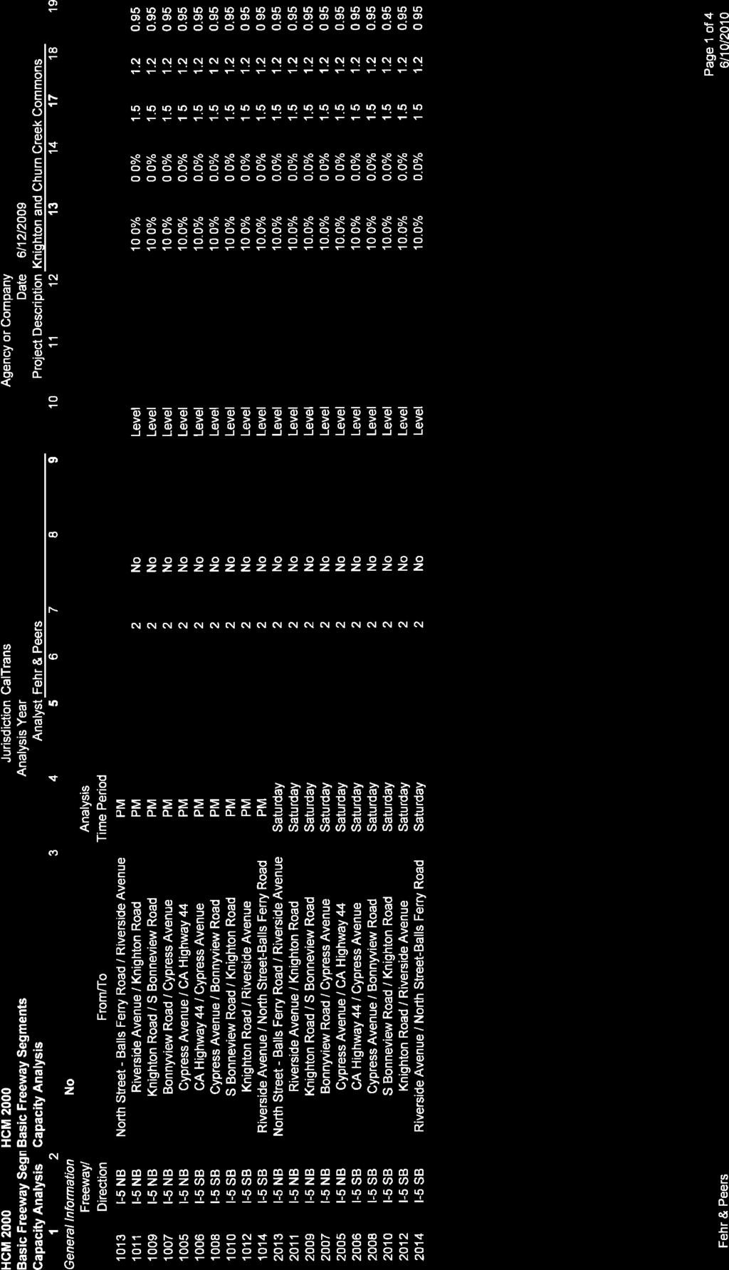
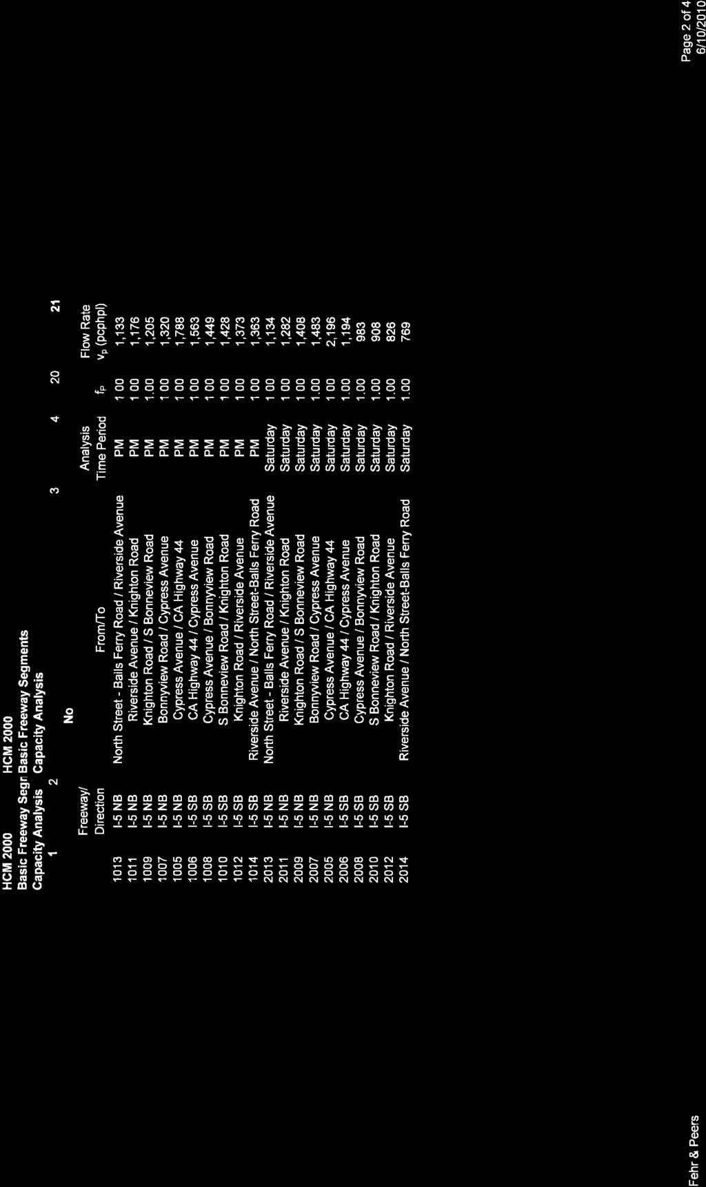
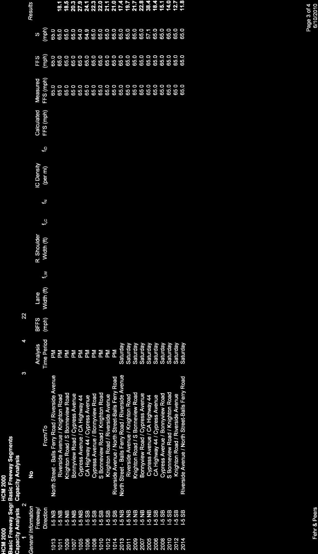
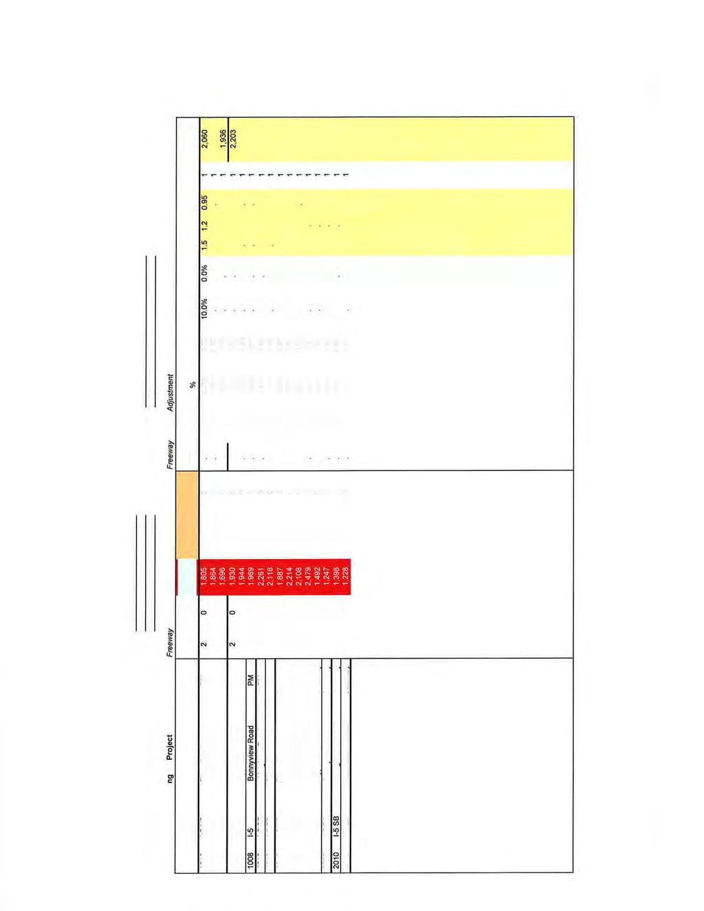
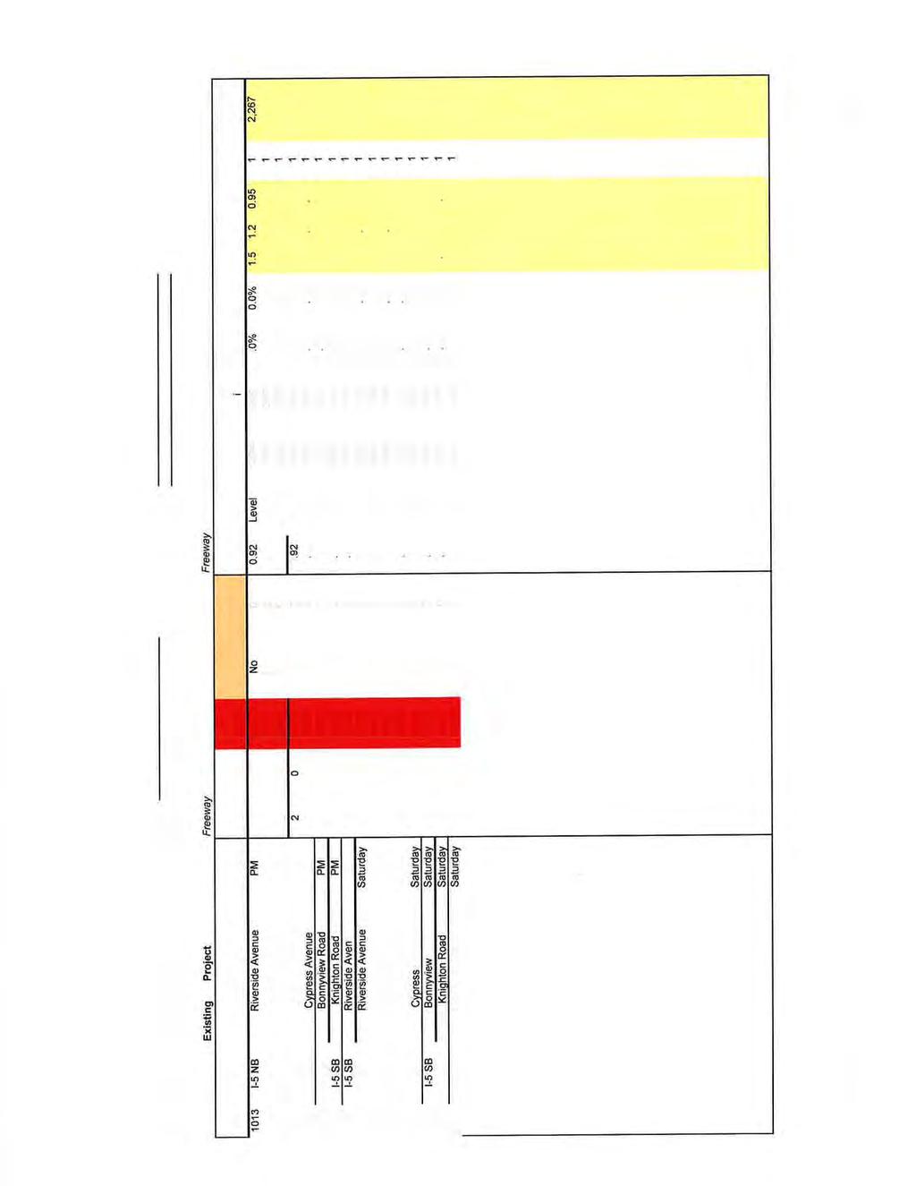
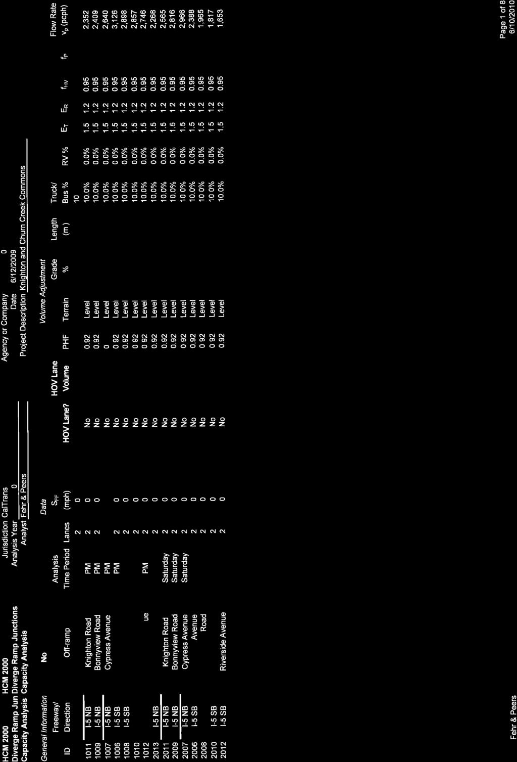
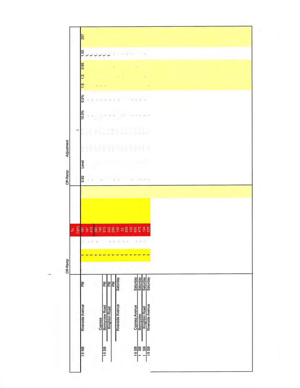
2 FREEWAY MAINLINE FAIR SHARE WEEKDAY PM PEAK HOUR Freeway Segment Direction From To Existing Cumulative No Project Cumulative Plus Project Fair Share % * North Street Riverside Avenue 1,986 3,260 3,478 6% Riverside Avenue Knighton Road 2,061 3,210 3,515 9% I-5 Northbound Knighton Road S. Bonnyview Road 2,111 3,430 3,788 9% S. Bonnyview Road Cypress Avenue 2,313 3,740 3,958 6% Cypress Avenue CA Highway 44 3,134 4,450 4,607 3% CA Highway 44 Cypress Avenue 2,739 4,430 4,586 3% Cypress Avenue S. Bonnyview Road 2,539 4,230 4,447 5% I-5 Southbound S. Bonnyview Road Knighton Road 2,503 4,350 4,707 8% Knighton Road Riverside Avenue 2,406 4,410 4,715 6% Riverside Avenue North Street 2,388 4,650 4,868 4% * Fair Share Calculation for these freeway mainline segments are based on a revised formula (Project Traffic/Cumulative Plus Project Traffic) to account for existing unacceptable Level of Service at each location that the proposed project is not responsible for. Source: Fehr & Peers, 2010 / Quad Knopf, 2010
3 FREEWAY MAINLINE FAIR SHARE SATURDAY MIDDAY PEAK HOUR Freeway Segment Direction From To Existing Cumulative No Project Cumulative Plus Project Fair Share % * North Street Riverside Avenue 1,987 3,260 3,533 8% Riverside Avenue Knighton Road 2,247 3,670 4,052 9% I-5 Northbound Knighton Road S. Bonnyview Road 2,467 3,960 4,405 10% S. Bonnyview Road Cypress Avenue 2,599 4,210 4,481 6% Cypress Avenue CA Highway 44 3,849 5,470 5,665 3% CA Highway 44 Cypress Avenue 2,092 3,380 3,576 5% Cypress Avenue S. Bonnyview Road 1,722 2,940 3,213 8% I-5 Southbound S. Bonnyview Road Knighton Road 1,592 2,710 3,158 14% Knighton Road Riverside Avenue 1,448 2,520 2,899 13% Riverside Avenue North Street 1,348 2,360 2,630 10% * Fair Share Calculation for these freeway mainline segments are based on a revised formula (Project Traffic/Cumulative Plus Project Traffic) to account for existing unacceptable Level of Service at each location that the proposed project is not responsible for. Source: Fehr & Peers, 2010 / Quad Knopf 2010
4 INTERSECTION FAIR SHARE CALCULATIONS WEEKDAY PM PEAK HOUR Location Existing Cumulative No Project Cumulative Plus Project Fair Share % Cypress Avenue / I-5 SB Ramps 4,039 4,900 5,076 * Cypress Avenue / I-5 NB Ramps 4,154 4,960 5,047 * Bonnyview Road / I-5 SB Ramps 2,651 4,050 4,321 No Mitigation Required Bonnyview Road / I-5 NB Ramps 2,208 3,270 3,419 12%*** Churn Creek Road / Rancho Road * Churn Creek Road / E Niles Lane Knighton Road / Airport Road 932 1,770 1,980 Knighton Road / Churn Creek Road 666 1,130 1,384 Knighton Rd / Churn Creek Rd / Pacheco Rd 692 1,220 1,552 No Mitigation Required No Mitigation Required No Mitigation Required No Mitigation Required Knighton Road / I-5 NB Ramps 786 1,270 3,615 ** Knighton Road / I-5 SB Ramps ** Knighton Road / Riverland Drive No Mitigation Required Riverside Avenue / I-5 SB Ramps 1,118 1,920 2,085 8%**** Riverside Avenue / I-5 NB Ramps 888 1,770 1,866 5%**** Knighton Rd / Project Access Churn Creek Rd / Project Access (1) Churn Creek Rd / Project Access (2) Churn Creek Rd / Project Access (3) To Be Constructed by Project To Be Constructed by Project To Be Constructed by Project To Be Constructed by Project
5 Location Existing Cumulative No Project Cumulative Plus Project Fair Share % Churn Creek Rd / Project Access (4) To Be Constructed by Project * Fair Share Calculation to be in accordance with Major Road Impact Fees Program adopted by the Board of Supervisors in June 1991 (Resolution , A Resolution Establishing Major Road Impact Fees for the South Central Regional Area). ** Fair Share Calculation to be in accordance with Shasta County Ordinance 665 Public Facilities Impact Fees. *** Fair Share Calculation = Project Traffic/Cumulative Plus Project Traffic Existing Traffic **** Fair Share Calculation for these intersections are based on a revised formula (Project Traffic/Cumulative Plus Project Traffic) to account for existing unacceptable Level of Service at each location that the proposed project is not responsible for. Source: Fehr & Peers and Quad Knopf, 2010 ROADWAY SEGMENT FAIR SHARE CALCULATIONS AVERAGE WEEKDAY VOLUME Location From Segment To Existing Cumulative No Project Cumulative Plus Project Fair Share % I-5 Southbound Ramps I-5 Northbound Ramps 5,572 7,500 14,549 * Knighton Road I-5 Northbound Ramps Churn Creek Road 6,705 11,100 25,021 * Churn Creek Road Churn Creek Road Airport Road 3,756 5,600 7,891 Knighton Road E. Niles Lane 2,753 4,800 6,034 E. Niles Lane Rancho Road 4,100 5,000 6,057 Rancho Road I-5 15,296 17,000 17,176 No Mitigation Required No Mitigation Required No Mitigation Required No Mitigation Required * Fair Share Calculation to be in accordance with Shasta County Ordinance 665 Public Facilities Impact Fees. Source: Fehr & Peers and Quad Knopf, 2010
6 Traffic Model Runs (6/10/2010) Fehr & Peers Transportation Consultants
7
8
9
10
11
12
13
14
15
16
17
18
19
20
21
22
23
24
25
26
27
28
29
30
31
32
33
34

35
36
37
38
39
40
41
42
43
44
45

46
47
48
49
50
51
52

53
54
55
56
57
58
59
60
61
4.1 Build Alternative 1 Construction Phasing
 SECTION 4 Implementation Plan This section discusses potential segmentation of the build alternatives into multiple projects for implementation of improvements to the NSH from Rabbit Creek Road to 36th
Community Meeting US 101/Peninsula Avenue Interchange Project JUNE 25, 2015
 Community Meeting US 101/Peninsula Avenue Interchange Project JUNE 25, 2015 Project Team Gary Heap, Engineering Division Manager Tracy Scramaglia, Senior Engineer Ramesh Sathiamurthy, AECOM Peter DeStefano,
4.11 TRAFFIC Existing Conditions Existing Project Site. Existing Street System
 4.11 TRAFFIC This traffic and circulation section is based on a Traffic Impact Study conducted by Linscott Law & Greenspan Engineers, which is provided in full in Appendix F. This traffic analysis has
REPORT TO PLANNING COMMISSION
 CITY OF Meeting Date: October 25, 2011 Agenda Item: Community Development Department Planning Division P. O. Box 151560, San Rafael, CA 94915-1560 PHONE: (415) 485-3085/FAX: (415) 485-3184 Case Numbers:
2.0 PURPOSE AND NEED. 2.1 Purpose. 2.2 Need Traffic Congestion in and around Downtown Derry
 2.0 PURPOSE AND NEED Taking into consideration agency and public input, the purpose and need for the Project was identified early in Project planning. As noted in Appendix A, for purposes of meeting the
Section 4.11 Traffic and Transportation 4.11 TRAFFIC AND TRANSPORTATION
 4.11 TRAFFIC AND TRANSPORTATION The following sections summarize the evaluation of the potential traffic/transportation impacts of the San Gabriel River Corridor Master Plan. First, the analysis methodology
PROJECT UPDATE BON AIR ROAD BRIDGE REPLACEMENT AND MAGNOLIA AVENUE WATER QUALITY FACILITIES
 CITY OF LARKSPUR PROJECT UPDATE BON AIR ROAD BRIDGE REPLACEMENT AND MAGNOLIA AVENUE WATER QUALITY FACILITIES PRESENTED BY Julian Skinner Larkspur Public Works Director DATE July 13, 2016 Bon Air Bridge
SR-2 Freeway Terminus Improvement Project
 SR-2 Freeway Terminus Improvement Project Welcome! Public Hearing, Mayberry Elementary June 16, 2009, 6:30 p.m. 8:30 p.m. Agenda 6:30 PM 6:50 PM Registration and Open House 6:50 PM 7:00 PM Welcome and
GENERAL PLAN CONSISTENCY ANALYSIS
 GENERAL PLAN CONSISTENCY ANALYSIS Prepared by Planning Staff 10/28/2013 APPLICABLE GOALS, POLICIES AND PROGRAMS FROM the LAND USE CHAPTER Goal LU-1 Policy LU-1.1 Policy LU-1.2 Goal LU-2 Protect the character
PROPOSED IMPROVEMENTS
 IV. PROPOSED IMPROVEMENTS The proposed improvements for each alternative carried forward are discussed below. A. FUNCTIONAL CLASSIFICATION AND ROADWAY CROSS-SECTIONS The classifications of the roadways
CITY OF LOS ANGELES INTER-DEPARTMENTAL CORRESPONDENCE
 CITY OF LOS ANGELES INTER-DEPARTMENTAL CORRESPONDENCE 20000 Prairie St. DOT Case No. 41443 Date: November 5, 2014 To: R. Nicolas Brown, Associate Zoning Administrator Department of City Planning From:
Division of Land / Environmental Review. Volume I FINAL ENVIRONMENTAL IMPACT REPORT WEST LOS ANGELES COMMUNITY PLAN AREA
 Division of Land / Environmental Review City Hall 200 N. Spring Street, Room 750 Los Angeles, CA 90012 Volume I FINAL ENVIRONMENTAL IMPACT REPORT ENV-2006-1914-EIR State Clearinghouse No. 2006061096 WEST
Welcome. Northern Segment of Hwy 100 I-90 to South of Madison Street Meeting Goals:
 Welcome Northern Segment of Hwy 100 I-90 to South of Madison Street Meeting Goals: - Review Environmental Assessment - Share Preferred Alternative -Receive Public Comments 2003 EA Preferred Alternative
WHAT IS THE PURPOSE OF THE OPEN HOUSE?
 WHAT IS THE PURPOSE OF THE OPEN HOUSE? OPEN HOUSE PURPOSE The purpose of the open house is to provide an update on the study process and introduce the preliminary concept alternatives. The open house provides
Transportation Improvements
 Transportation Improvements 0 0 Volume II of the Final EIS for the DHS Headquarters consolidation at St. Elizabeths includes analysis to transportation improvements for the DHS Headquarters Consolidation
MEMORANDUM. California State University Channel Islands Evacuation Planning Analysis
 MEMORANDUM Date: To: From: Subject: Maggie Tougas, Cary Bearn & Miguel Nunez, AICP Evacuation Planning Analysis LA17-2966 This memorandum was prepared to assist (CSUCI) with evacuation planning at the
NORTH, NORTH REDWOOD BOULEVARD CORRIDOR STUDY
 BOULEVARD CORRIDOR STUDY Southern Central Northern STUDY AREA OPPORTUNITIES AND CONSTRAINTS BOULEVARD CORRIDOR WORKSHOP Constraints Wetlands For illustrative purposes only BINFORD RD RUSH LANDING RD BOULEVARD
Chapter Three. Recommendations
 Chapter Three Recommendations Recommended Approach Based on the market analysis and further market research, three retail development strategies have been formulated that could be pursued to expand the
Creative Engineering Group Inc, (Creative) Construction Engineering and Inspection (CEI) Professionals
 Construction Engineering and Inspection (CEI) Professionals") ABOUT US Creative Engineering Group Inc, (Creative) is a Construction Engineering and Inspection (CEI) firm established in 2006 by two Principals Rick Estripeaut & Sri Mavanur. In the last decade Creative
ABOUT US Creative Engineering Group Inc, (Creative) is a Construction Engineering and Inspection (CEI) firm established in 2006 by two Principals Rick Estripeaut & Sri Mavanur. In the last decade Creative
Alaskan Way, Promenade, and Overlook Walk Final EIS Appendix D - Supplemental Draft EIS Comments and Responses October 2016.
 B-001-001 The use of Columbia Street for two-way transit was a decision made by King County Metro as part of its Southwest Transit Pathway evaluation. This project is separate from AWPOW. B-001-002 Modeling
FANSHAWE PARK ROAD/RICHMOND STREET INTERSECTION IMPROVEMENTS. PUBLIC INFORMATION CENTRE 2 June 16, 2016
 FANSHAWE PARK ROAD/RICHMOND STREET INTERSECTION IMPROVEMENTS Municipal Class Environmental Assessment PUBLIC INFORMATION CENTRE 2 June 16, 2016 ACCESSIBILITY Under the Accessibility Standards 2015 for
SEATTLE PACIFIC UNIVERSITY MIMP Condition Status Matrix: July 1, 2015 June 30, 2016
 SEATTLE PACIFIC UNIVERSITY MIMP Condition Status Matrix: July 1, 2015 June 30, 2016 # CITY COUNCIL CONDITION FULFILLED/ 1 Modify the MIMP to replace the last sentence of the first paragraph on page 43
Response: The public school use, including the SWM facility, is within the R-1 District.
 Loudoun County School Board Dulles North Elementary School (ES-31) CMPT 2017-0006 and SPMI 2017-0015 First Response to Referral Comments Zoning Administration Comments dated October 2, 2017 Comment 1:
I-95 Girard Avenue Interchange Near Neighbors Meeting. Project Status
 I-95 Girard Avenue Interchange Project Status Construction is underway for Phase 1 and 2. Phase 3 construction will begin early 2014. Overall Project Area and Schedule GR0: Completed GR0: Completed in
A raised and landscaped median will be constructed in South College Avenue between Trilby Road and Skyway Drive.
 5.0 ACCESS CONTROL PLAN This section presents the Access Control Plan Update which has been formulated through the considerable input of the governing agencies, business owners, organized homeowner groups,
Mavis Road Class Environmental Assessment
 Mavis Road Class Environmental Assessment Public Information Centre #2 Wednesday November 9, 2016 6:00 to 8:00 p.m. Please sign in and complete a comment sheet Review the displays on your own or join in
Whitehurst Freeway Deconstruction Feasibility Study
 Whitehurst Freeway Deconstruction Feasibility Study Draft Existing Conditions Report Prepared By: For: District Department of Transportation District of Columbia October 2005 TABLE OF CONTENTS 1. INTRODUCTION...1-1
Moving The Metro. A special construction update for the metro Omaha area.
 Moving The Metro A special construction update for the metro Omaha area. ebraska Department of Roads Spring/Summer 2017 I-80 / I-480 / US-75 Interchange The improvements on this project consist of bridge
4.0 RESPONSE TO COMMENTS
 4.0 RESPONSE TO COMMENTS 4.3.46 Response to Comment Letter I-25 Response to Comment I-25-1. See Master Responses Land Use 2 and Growth Inducement 1. Response to Comment I-25-2. Section 2.3.9, Volume III
ARGENTA TRAIL (CSAH 28/63) REALIGNMENT SOUTH PROJECT (CP 63-25)
 REALIGNMENT SOUTH PROJECT (CP 63-25)") ARGENTA TRAIL (CSAH 28/63) REALIGNMENT SOUTH PROJECT (CP 63-25) Preliminary Design Report February 2015 Prepared For: City of Inver Grove Heights Dakota County Prepared By: Kimley-Horn and Associates,
ARGENTA TRAIL (CSAH 28/63) REALIGNMENT SOUTH PROJECT (CP 63-25) Preliminary Design Report February 2015 Prepared For: City of Inver Grove Heights Dakota County Prepared By: Kimley-Horn and Associates,
ARLINGTON COUNTY, VIRGINIA. County Board Agenda Item Meeting of January 28, 2017 SUPPLEMENTAL REPORT
 ARLINGTON COUNTY, VIRGINIA County Board Agenda Item Meeting of January 28, 2017 SUPPLEMENTAL REPORT DATE: January 26, 2017 SUBJECT: The Virginia Department of Transportation s Transform I-66 Inside the
6 November 10, 2010 Public Hearing APPLICANT: ZION TEMPLE MINISTRIES COGIC
 REQUEST: Conditional Use Permit (religious use) 6 November 10, 2010 Public Hearing APPLICANT: ZION TEMPLE MINISTRIES COGIC PROPERTY OWNER: PHYLLIS A. & ERNEST L. HUDSON TRUST STAFF PLANNER: Karen Prochilo
Puget Sound Gateway Program Team. Phase 1, SR 509 Completion Project NEPA Re-evaluation
 Land Use COPY TO: PREPARED BY: Project File DATE: November, 2017 SUBJECT 1. Introduction Puget Sound Gateway Program Team Phase 1, SR 509 Completion Project NEPA Re-evaluation This memorandum was prepared
North Carolina Department of Transportation Project Development and Environmental Analysis Branch
 North Carolina Department of Transportation Project Development and Environmental Analysis Branch Citizens Informational Workshop I-85, from I-485 to NC 73 Mecklenburg and Cabarrus Counties October 30,
Table of Contents. Executive Summary...S-1
 Table of Contents Executive Summary...S-1 1: Project Description... 1-1 A. Project Identification... 1-1 B. Background to the Proposed Project... 1-5 C. Description of the Project Site... 1-8 D. Description
ARLINGTON COUNTY, VIRGINIA. County Board Agenda Item Meeting of January 28, 2017 SUPPLEMENTAL REPORT-2
 ARLINGTON COUNTY, VIRGINIA County Board Agenda Item Meeting of January 28, 2017 SUPPLEMENTAL REPORT-2 DATE: January 27, 2017 SUBJECT: The Virginia Department of Transportation s Transform I-66 Inside the
Attachment No. 8. SUMMARY OF IVY STATION INITIAL STUDY/MITIGATED NEGATIVE DECLARATION (IS/MND) COMMENTS RECEIVED AND RESPONSES February 2016
 COMMENTS RECEIVED AND RESPONSES February 2016") Attachment No. 8 SUMMARY OF IVY STATION INITIAL STUDY/MITIGATED NEGATIVE DECLARATION (IS/MND) COMMENTS RECEIVED AND RESPONSES February 2016 I. INDIVIDUAL COMMENT LETTERS The City received 17 comment letters
Attachment No. 8 SUMMARY OF IVY STATION INITIAL STUDY/MITIGATED NEGATIVE DECLARATION (IS/MND) COMMENTS RECEIVED AND RESPONSES February 2016 I. INDIVIDUAL COMMENT LETTERS The City received 17 comment letters
Commerce Station (P06-018) Mitigation Monitoring Program
 Mitigation Monitoring Program") Commerce Station (P06-018) Mitigation Monitoring Program 101 Impact Number Transportation and Circulation 4.2-1 Mitigation Measure 4.2 Transportation and Circulation 4.2-1(a) Del Paso Road and El Centro
Commerce Station (P06-018) Mitigation Monitoring Program 101 Impact Number Transportation and Circulation 4.2-1 Mitigation Measure 4.2 Transportation and Circulation 4.2-1(a) Del Paso Road and El Centro
MEMORANDUM. DATE: March 15, Chairman and Members Community Redevelopment Agency. Leif J. Ahnell, C.P.A., C.G.F.O. Executive Director
 MEMORANDUM DATE: March 15, 2019 TO: FROM: Chairman and Members Community Redevelopment Agency Leif J. Ahnell, C.P.A., C.G.F.O. Executive Director SUBJECT: Camino Square, IDA No. CRP-16-02, located at 171
4. ENVIRONMENTAL IMPACT ANALYSIS 7. LAND USE AND PLANNING
 4. ENVIRONMENTAL IMPACT ANALYSIS 7. LAND USE AND PLANNING 4.7.1 INTRODUCTION The following analysis discusses the consistency of the Proposed Project with the corresponding land use and zoning designations
Debra Larson and Director Malcolm Dougherty
 District 5 District Director Timothy Gubbins Looking south at US 101/San Juan Road interchange in Monterey County Provide a safe, sustainable, integrated and efficient transportation system to enhance
RESOLUTION NO. PC
 RESOLUTION NO. PC 2018-14 A RESOLUTION OF THE CITY OF ENCINITAS PLANNING COMMISSION RECOMMENDING CITY COUNCIL ADOPTION OF ORDINANCE NO. 2018-05, ADOPTING AMENDMENTS TO THE LOCAL COASTAL PLAN, NORTH 101
Cotton Belt Corridor. Area Focus Group (AFG) Richardson/Plano August 24, John Hoppie, Capital Planning
 Richardson/Plano August 24, John Hoppie, Capital Planning") Cotton Belt Corridor Area Focus Group (AFG) Richardson/Plano August 24, 2017 John Hoppie, Capital Planning 0 Agenda Design Update Environmental Update Documentation of Existing Conditions Noise Traffic
Cotton Belt Corridor Area Focus Group (AFG) Richardson/Plano August 24, 2017 John Hoppie, Capital Planning 0 Agenda Design Update Environmental Update Documentation of Existing Conditions Noise Traffic
ENVIRONMENTAL IMPACT REPORT COMPREHENSIVE GENERAL PLAN AND ZONING ORDINANCE SCH NUMBER:
 ENVIRONMENTAL IMPACT REPORT FOR THE CITY OF BANNING COMPREHENSIVE GENERAL PLAN AND ZONING ORDINANCE SCH NUMBER: 2005011039 Prepared for: City of Banning 99 East Ramsey Street Banning, CA 92220 Prepared
Memorandum CITY OF DALLAS. Riverfront Boulevard Design From Continental Avenue to Cadiz Street
 Memorandum DATE November 10, 2011 CITY OF DALLAS TO Trinity River Corridor Project Committee Members: Vonciel Jones Hill (Chair) Linda Koop (Vice Chair), Monica Alonzo, Scott Griggs, Angela Hunt, and Delia
Boster, Kobayashi & Associates 59 Rickenbacker Circle Office: (925) P.O. Box 2049 Fax: (925) Livermore, CA
 P.O. Box 2049 Fax: (925) Livermore, CA") Boster, Kobayashi & Associates 59 Rickenbacker Circle Office: (925) 447-6495 P.O. Box 2049 Fax: (925) 447-6589 Livermore, CA 94551-2049 RICHARD K. HAYGOOD, P.E. Curriculum Vitae EDUCATION: M.B.A. UCLA
Boster, Kobayashi & Associates 59 Rickenbacker Circle Office: (925) 447-6495 P.O. Box 2049 Fax: (925) 447-6589 Livermore, CA 94551-2049 RICHARD K. HAYGOOD, P.E. Curriculum Vitae EDUCATION: M.B.A. UCLA
ACCESS MANAGEMENT REPORT U.S S.H. 1 TO S.H. 14 S.H U.S. 287 TO I-25
 ACCESS MANAGEMENT REPORT U.S. 287 - S.H. 1 TO S.H. 14 S.H. 14 - U.S. 287 TO I-25 Prepared by: City of Fort Collins Transportation Planning 7951 East Maplewood Avenue, Suite 200 210 E. Olive, P.O. Box 580
Kurt G. Larson, PE, PTOE
 Kurt G. Larson, PE, PTOE Summary With more than 20 years of experience, Mr. Larson has a well-rounded technical career with roadway/geometric design, intelligent transportation systems, traffic signal
Chesterfield County Project Update
 Chesterfield County Project Update SOUTHEAST HIGH SPEED RAIL TIER II ENVIRONMENTAL IMPACT STATEMENT RICHMOND, VA, TO RALEIGH, NC CHESTERFIELD COUNTY, VA OFFICIALS BRIEFING February 2013 Federal Railroad
THE NE QUADRANT LAND USE PLAN
 THE NE QUADRANT LAND USE PLAN APPENDIX - VOLUME 3 APPEND. 9 TRANSPORTATION & APPEND. 13 DR/GR LAND USE Aug. 5, 2013 Barraco and Assoc., Inc. Stuart and Assoc. JMB Transportation Passarella and Assoc. THE
NOTICE OF PREPARATION OF ENVIRONMENTAL IMPACT REPORT
 NOTICE OF PREPARATION OF ENVIRONMENTAL IMPACT REPORT TO: State Clearinghouse, Responsible and Trustee Agencies, and Other Interested Parties DATE: May 18, 2017 SUBJECT: Notice of Preparation of Environmental
Open House Public Involvement Meeting Howland High School Cafeteria, 200 Shaffer Drive NE, Warren, Ohio. Informational Handout
 Open House Public Involvement Meeting Howland High School Cafeteria, 200 Shaffer Drive NE, Warren, Ohio SR 46 (Niles Cortland Road) and SR 82 Proposed Improvements Howland Township, Trumbull County, Ohio
Municipality of Anchorage. Community Council Survey Capital Projects Needs Ranking Survey (ALPHABETICAL) Airport Heights
 Airport Heights") ANCHORAGE PARKS & RECREATION Nichols Park Design and improve neighborhood park 2008 Challenge Grant applicant. 2008 $500K State Grant for Neighborhood Parks. Tikishla Park Lighting, paved parking, hockey
ANCHORAGE PARKS & RECREATION Nichols Park Design and improve neighborhood park 2008 Challenge Grant applicant. 2008 $500K State Grant for Neighborhood Parks. Tikishla Park Lighting, paved parking, hockey
Citizen Concerns I-16/I-75 Interchange Design
 Citizen Concerns I-16/I-75 Interchange Design Project # NH-IM-16-1(92), NH-IM-16-1(131), NH-IM-75-2(177), & NM-16-1(104) P.I. # 311000, 311005, 311400, & 311410 Shirley Hills & North Highlands Neighborhood
Preliminary Construction & Traffic Planning Intro to Shop Local/Shop Eglinton Initiative. June 27, 2012
 Preliminary Construction & Traffic Planning Intro to Shop Local/Shop Eglinton Initiative June 27, 2012 Agenda Introductions Project Update Preliminary Crosstown Construction & Traffic Planning Overview
Jordan Harrison, Planner III, San Francisco Recreation and Park Department
 Date December 8, 2015 To: Through: From: Subject: Recreation and Park Commission Philip A. Ginsburg, General Manager Dawn Kamalanathan, Director, Capital & Planning Division Jordan Harrison, Planner III,
DOWNTOWN REDMOND LINK EXTENSION SEPA Addendum to the East Link Project Final Environmental Impact Statement
 DOWNTOWN REDMOND LINK EXTENSION 2018 SEPA Addendum to the East Link Project Final Environmental Impact Statement AUGUST 2018 Downtown Redmond Link Extension SEPA Addendum to the 2011 East Link Project
4GROWTH MANAGEMENT 4.1 BACKGROUND AND CONTEXT 4-1
 4GROWTH MANAGEMENT 4.1 BACKGROUND AND CONTEXT The purpose of the Growth Management Element is to provide guidance and specific actions to manage and mitigate the impacts of future urban growth and development
APPENDIX D TRANSPORTATION PLANNING FACTORS
 APPENDIX D TRANSPORTATION PLANNING FACTORS 440 Park Avenue South New York, NY 10016 tel: 212 696-0670 fax: 212 213-3191 www.akrf.com To: From: Subject: Eloise Hirsh Project Coordinator, DPR Angelyn Chandler,
4.1 AESTHETICS AND VISUAL QUALITY
 SCOPE AND METHODOLOGY 4.1 AESTHETICS AND VISUAL QUALITY This section evaluates the potential impacts to aesthetics and visual quality. Aesthetics refers to visual resources and the quality of what can
5 Eireann Quay Site Plan Control Application
 STAFF REPORT ACTION REQUIRED 5 Eireann Quay Site Plan Control Application Date: March 12, 2015 To: From: Wards: Reference Number: Toronto and East York Community Council Director, Community Planning, Toronto
Right-of-Way Acquisitions and Relocations Technical Memorandum
 Right-of-Way Acquisitions and Relocations Technical Memorandum Southeast Extension Project Lincoln Station to RidgeGate Parkway Prepared for: Federal Transit Administration Prepared by: Denver Regional
Population and Demographics Alternatives Development Design Criteria Stormwater Management Guidelines Alternative 1: No Build
 Table of Contents Executive Summary... 1 Introduction... 1 Purpose and Need... 1 Alternatives Development... 2 Impacts and Costs... 2 Next Steps... 3 Findings Report... 5 Purpose and Need... 5 Introduction...
112th Avenue Light Rail Options Concept Design Report JUNE 2010 PREPARED FOR PREPARED BY TBG PGH
 112th Avenue Light Rail Options Concept Design Report JUNE 2010 PREPARED FOR PREPARED BY TBG060310124909PGH C ontents Introduction 1 Project Overview 1 Public Involvement and Technical Coordination 4 Description
Route 7/15 Norwalk. Route 7/15 Norwalk Project Project Advisory Committee Meeting #5. Wednesday, November 14 th, Norwalk City Hall
 Route 7/15 Norwalk Project Project Advisory Committee Meeting #5 Route 7/15 Norwalk PAC Meeting #5 November 14, 2018 Wednesday, November 14 th, Norwalk City Hall Route 7/15 Norwalk - AGENDA Introductions
Prepared by: Casey Kempenaar, Senior Planner
 CITY OF CITRUS HEIGHTS PLANNING DIVISION STAFF REPORT PLANNING COMMISSION MEETING September 13, 2017 Prepared by: Casey Kempenaar, Senior Planner REQUEST The applicant requests a Design Review Permit Modification
FY STATEWIDE TRANSPORTATION IMPROVEMENT PROGRAM Transportation Authorities Project Descriptions
 Bridge Rehabilitation Burlington County Bridge Commission Burlington-Bristol Bridge This project includes the replacement of the existing span decks, repairs to the existing walkway, railing and ladder
Project Status. Construction is underway for Phase 3. Overall Project Area and Schedule. Schedule of Current Construction Phases.
 I-95 Avenue Interchange Project Status Construction is underway for Phase 3. Overall Project Area and Schedule Phase 0: Completed 2010 Section GR0: Completed in Fallin 2010 Phase 2: Completed Section GR2:
2014 PSPE Philadelphia Chapter Outstanding Engineering Achievement Award Nomination
 2014 PSPE Philadelphia Chapter Outstanding Engineering Achievement Award Nomination Route 29 Roadway Improvement Project SR 0029, Section AL2 Charlestown Township, Chester County, PA Nomination Form Route
SPECIFIC DESIGN PLAN
 The Maryland-National Capital Park and Planning Commission Prince George's County Planning Department Development Review Division 301-952-3530 Note: Staff reports can be accessed at www.mncppc.org/pgco/planning/plan.htm.
CHAPTER 10-D GREATER MONTEREY PENINSULA AREA PLAN
 CHAPTER 10-D GREATER MONTEREY PENINSULA AREA PLAN GREATER MONTEREY PENINSULA AREA PLAN SUPPLEMENTAL POLICIES 1.0 - Land Use GMP-1.1 GMP-1.2 GMP-1.3 GMP-1.4 GMP-1.5 GMP-1.6 GMP-1.7 GMP-18.6 The County shall
Glenn Highway MP DSR. Landscape Narrative
 Glenn Highway MP 34-42 DSR Landscape Narrative Project Landscape Goals The Glenn Highway MP 34-42 Project extends through a variety of landscape types typical to the Matanuska-Susitna Valley. In general,
New Stanton Project Update July 3, 2012
 New Stanton Project Update July 3, 2012 The Needs BACKGROUND INFO I-70 Geometric Concerns Substandard Horizontal & Vertical Clearance at Center Ave. Bridge (The Center Avenue Bridge is Replaced in all
7 June 13, 2012 Public Hearing
 7 June 13, 2012 Public Hearing REQUEST: Conditional Use Permit (Childcare) APPLICANT: BASILEIA EMPOWERING MINISTRIES PROPERTY OWNER: CONNEMARA ASSOCIATES, LLC STAFF PLANNER: Faith Christie ADDRESS / DESCRIPTION:
3.0 Existing Corridor Infrastructure
 3.0 Existing Corridor Infrastructure An analysis was conducted of the existing I-526 highway facility infrastructure to serve as a baseline for consideration of future improvements. The detailed analysis
Findings of Fact and Conclusion
 TH 169/101 st Avenue Interchange Project S.P. 2750-92 Proposer: City of Brooklyn Park RGU: Minnesota Department of Transportation Date: January 2017 Table of Contents Chapter 1 Administrative Background...
2040 Long Range Transportation Plan
 2040 Long Range Transportation Plan Adopted: April 15, 2013 APPENDIX D HIGHWAY NEEDS PLAN PROJECTS FREDERICKSBURG Existing and Committed Projects Fall Hill Avenue/Mary Washington Blvd. (Fredericksburg)
3. Additional driveways may be permitted where determined by the Planning Commission to adequately accommodate traffic or ensure public safety.
 ARTICLE 10 ACCESS MANAGEMENT Section 10.01 Purpose. The purpose of this Article is to protect the substantial public investment in the City s street system by preserving the traffic capacity of existing
Zoning Ordinance Section 1.100
 4.800 (ZC 98-45; Ordinance No. 98-9-13) 4.801 Purpose To provide appropriate design standards for the development of properties within the State Highway 121 corridor. These standards recognize the significance
Burton Station Village Community Meeting February 26, 2014
 February 26, 2014 SGA Plan Overview Recent announcements by the City of Norfolk regarding the closure of Lake Wright Golf Course and retail development proposals Update on infrastructure improvement plans
TRANSPORTATION ELEMENT
 TRANSPORTATION ELEMENT GOAL I: To create and maintain a safe, efficient and aesthetic transportation system that encourages multi-modal transportation and promotes the mobility strategies of the Ocala
Green Book 7 th Edition Summary of Changes. Jim Rosenow NCITE Geometric Design Committee August 30, 2018
 Green Book 7 th Edition Summary of Changes Jim Rosenow NCITE Geometric Design Committee August 30, 2018 Outline 1. The drama 2. Chapter 1 rewrite 3. The rest of the book 2 Outline 1. The drama 2. Chapter
Appendix G Response to Comments
 Appendix G Response to Comments This appendix contains the comments received during the public circulation and comment period (May 27, 2008 to July 11, 2008). The comments have been numbered (Comment Set
RIVERSIDE, Newton MA June 9, 2011
 June 9, 2011 TONIGHT S AGENDA: 1.Project Update (5 min.) 2.Master Plan Update (10 min.) 3.Environmental Update (5 min.) 4.Traffic Plan Update (25 min.) Questions PROJECT STATUS UPDATE Responding / Clarifying
3.5 - Land Use and Planning
 City of Irvine - William Lyon Homes: Vista Verde Land Use and Planning 3.5 - Land Use and Planning 3.5.1 - Introduction This section describes existing land uses, applicable land use plans, policies or
COMMUNITY DEVELOPMENT DEPARTMENT CITY HALL TORRE AVENUE CUPERTINO, CA TELEPHONE: (408)
") COMMUNITY DEVELOPMENT DEPARTMENT CITY HALL 10300 TORRE AVENUE CUPERTINO, CA 95014 3255 TELEPHONE: (408) 777 3308 www.cupertino.org JOINT CITY COUNCIL AND PLANNING COMMISSION STUDY SESSION STAFF REPORT
COMMUNITY DEVELOPMENT DEPARTMENT CITY HALL 10300 TORRE AVENUE CUPERTINO, CA 95014 3255 TELEPHONE: (408) 777 3308 www.cupertino.org JOINT CITY COUNCIL AND PLANNING COMMISSION STUDY SESSION STAFF REPORT
Urban Planning and Land Use
 Urban Planning and Land Use 701 North 7 th Street, Room 423 Phone: (913) 573-5750 Kansas City, Kansas 66101 Fax: (913) 573-5796 Email: planninginfo@wycokck.org www.wycokck.org/planning To: From: City Planning
Proposed FY 2004 TRANSPORTATION CAPITAL PROGRAM New Jersey Department of Transportation Projects
 30 130 Collingswood/Pennsauken ( B) 155C Vicinity of Cooper River Bridge at Park Drive to 200 feet north of PATCO Railroad Bridge This project may provide for the construction of a proposed new bridge
Revised Long Range Transportation Plan
 Revised Long Range Transportation Plan Auburn, Alabama Prepared for: City of Auburn, Alabama Prepared by: Skipper Consulting, Inc. June 2006 Revised Long Range Transportation Plan City of Auburn, Alabama
C. WATER. 1. Surface Water Runoff. See Section C.3, Flood Hazard/Mudflow Hazard, page Ground Water
 C. WATER 1. Surface Water Runoff See Section C.3, Flood Hazard/Mudflow Hazard, page 67. 2. Ground Water Determined not significant by the October 1984 and January 1999 Initial Studies conducted by the
SANTA BARBARA COUNTY PLANNING COMMISSION Coastal Zone Staff Report for Highway 101: Carpinteria to Santa Barbara Local Coastal Program Amendment
 SANTA BARBARA COUNTY PLANNING COMMISSION Coastal Zone Staff Report for Highway 101: Carpinteria to Santa Barbara Local Coastal Program Amendment Hearing Date: May 2, 2018 Staff Report Date: April 12, 2018
Preserving Green Streetscape Character on Hillside Drive
 STAFF REPORT ACTION REQUIRED Preserving Green Streetscape Character on Hillside Drive Date: February 19, 2014 To: From: Toronto and East York Community Council Deputy City Manager, Cluster B Wards: Toronto-Danforth,
ACTIONS Board of Supervisors Meeting of October 11, 2006
 ACTIONS Board of Supervisors Meeting of October 11, 2006 1. Call to Order. Meeting was called to order at 2:30 by the Chairman, Mr. Rooker. All BOS members were present. Also present were Bob Tucker, Larry
4.0 AFFECTED ENVIRONMENT AND ENVIRONMENTAL CONSEQUENCES
 4.0 AFFECTED ENVIRONMENT AND ENVIRONMENTAL CONSEQUENCES The following sections discuss the impacts associated with environmental resources for the tunneling method Alternatives A and B. The construction
III. ENVIRONMENTAL SETTING
 III. ENVIRONMENTAL SETTING A. OVERVIEW OF ENVIRONMENTAL SETTING Regional Setting The project site is located in Los Angeles County in the northeastern San Fernando Valley, approximately 18 miles north
Clay Street Bridge Replacement Project
 Clay Street Bridge Replacement Project Frequently Asked Questions (FAQs) No. 2 April 4, 2018 The project is located in downtown Placerville on Clay Street between US Highway 50 and Main Street and Cedar
MONTGOMERY COUNTY PLANNING DEPARTMENT THE MARYLAND-NATIONAL CAPITAL PARK AND PLANNING COMMISSION
 MONTGOMERY COUNTY PLANNING DEPARTMENT THE MARYLAND-NATIONAL CAPITAL PARK AND PLANNING COMMISSION MCPB Item No. Date: 6/30/2016 Washington Adventist Hospital, Site Plan Amendment No. 82008021E Michael Brown,
MARGARITA ROAD. Harveston Community 1,900 homes centered around Harveston Lake DATE STREET ±180,000 CPD. Future French Valley Overpass On/Off Ramp
 10.58 NET COMMERCIAL ACRES FOR SALE MURRIETA CREEKSIDE JACKSON AVE & ARBORETUM WAY MURRIETA, CA MURRIETA SPRINGS PLAZA MURRIETA TOWN CENTER SCGA Golf Course FEATURES: Excellent freeway visibility MURRIETA
TRANSPORTATION ELEMENT GOALS, OBJECTIVES, AND POLICIES
 TRANSPORTATION ELEMENT GOALS, OBJECTIVES, AND POLICIES GOAL 2 The City shall provide a safe, convenient, effective, and energy efficient multimodal transportation system which is coordinated with the Future
Public Information Centre #1
 and Highway 401 Interchange Improvements WELCOME Public Information Centre #1 Veterans Memorial Parkway Extension and Highway 401 Interchange Improvements Study May 23, 2012 4 p.m. to 7 p.m. Brief Overview