MONTGOMERY COUNTY PLANNING DEPARTMENT THE MARYLAND-NATIONAL CAPITAL PARK AND PLANNING COMMISSION
|
|
|
- Marilynn Chastity Bond
- 5 years ago
- Views:
Transcription

1 MONTGOMERY COUNTY PLANNING DEPARTMENT THE MARYLAND-NATIONAL CAPITAL PARK AND PLANNING COMMISSION MCPB Item No. Date: 6/30/2016 Washington Adventist Hospital, Site Plan Amendment No E Michael Brown, Area 1 Division, Michael.Brown@montgomeryplanning.org, Khalid Afzal, Planner Supervisor, Area 2 Division, Khalid.Afzal@montgomeryplanning.org, Glenn Kreger, Chief, Area 2 Division, Glenn.Kreger@montgomeryplanning.org, Description Request for an 803,570-square-foot, 170-bed Hospital including the main Hospital building with Emergency Room, an ambulatory care building, two medical office buildings, the Center of Spiritual Life and Healing, two parking garages, a parking lot, a helipad, and associated circulation, landscaping, stormwater management and other improvements; Located on the west side of Plum Orchard Drive, approximately 400 feet southwest of Broadbirch Drive; acre site zoned LSC in the White Oak Science Gateway Master Plan area. Completed: 6/20/2016 Summary Staff recommends approval of the Site Plan Amendment with conditions. The original APF approval for this project was made in The project is returning to the Planning Board to make minor site plan changes and is now reviewed under the LSC Zone (rather than the I-1 and I-3 zones) and the new Zoning Ordinance. The Planning Board must therefore make new site plan and master plan consistency findings. Applicant will abandon the Special Exception S-2721 (and S-2721-A) and its conditioned transportation improvements, since a hospital is permitted by right in the LSC zone. Since the property s APF approval is still valid, the Applicant contends that the Planning Board cannot require any off-site improvements under the site plan process and therefore opposes the conditions of approval requiring a new traffic signal at the intersection of Broadbirch Drive and Plum Orchard Drive and the associated intersection improvements. Applicant requests approval for standard method development under the current LSC Zone and will abandon the Special Exception, S-2721 and S-2721-A granted under I-3 Zone for the Hospital use along with the conditioned transportation improvements. Applicant seeks modification of certain Development Standards in the LSC Zone. Applicant requests amendment of Category I Forest Conservation Easement to allow for the construction of a redundant water line. 1
2 STAFF RECOMMENDATION AND CONDITIONS OF APPROVAL Staff recommends approval of Site Plan E with conditions for a total of 803,570 square feet of Hospital use with 170 beds and including the main Hospital building, an ambulatory care building, two medical office buildings, the Center of Spiritual Life and Healing, two parking garages, a parking lot, a helipad, and associated parking and other improvements as shown on the certified site plan. All site development elements shown on the latest electronic version as of the date of this Staff Report submitted via eplans to the M-NCPPC are required except as modified by the following conditions. 1 Conformance with Previous Approvals and Agreements 1. Special Exception Conformance Prior to Certified Site Plan approval, the Applicant must abandon Special Exception S-2721 dated October 27, 2008, and subsequent amendment (S-2721-A) dated September 22, Preliminary Plan Conformance The development must comply with the conditions of approval for Preliminary Plan No A as listed in the Planning Board Resolution MCPB No dated February 13, 2008, and Preliminary Plan No , unless amended. This includes, but is not limited to, all references to density, rights-ofway, dedications, easements, transportation conditions, Montgomery County Department of Transportation (MCDOT) conditions, and Montgomery County Department of Permitting Services (MCDPS) stormwater conditions. Environment Forest Conservation & Tree Save 3. The development must comply with the conditions of the amended Final Forest Conservation Plan dated June 1, a. Prior to the issuance of the first building permit, the Applicant must record a revised Category I Conservation Easement, approved by the M-NCPPC Office of the General Counsel, in the Montgomery County Land Records by deed. The Liber and Folio for the easement must be referenced on the record plat. b. Prior to the issuance of the first building permit, the Applicant must pay the fee-in-lieu for the acres forest planting requirement. c. The Applicant must plant a minimum total of eight caliper inches of native canopy trees as mitigation for the tree variance impacts on the Property within one calendar year or two growing seasons after the issuance of the first Use and Occupancy permit for the main Hospital building. The trees must be a minimum of three-inch caliper. Stormwater Management 4. The Planning Board accepts the recommendations of the Montgomery County Department of Permitting Services (MCDPS) Water Resources Section in its stormwater management (SWM) concept letter dated April 1, 2015, and hereby incorporates them as conditions of approval. The Applicant must comply with 1 For the purposes of these conditions, the term Applicant shall also mean the developer, the owner or any successor (s) in interest to the terms of this approval. 2
3 each of the recommendations as set forth in the letter, which the MCDPS Water Resources Section may amend if the amendments do not conflict with other conditions of Site Plan approval. The MCDPS Water Resources Section will review, approve, and inspect all landscaping within the SWM easements and facilities. Transportation and Circulation Traffic Mitigation Agreement 5. Prior to the issuance of the first Use and Occupancy permit for the main Hospital building, the Applicant must enter into a Traffic Mitigation Agreement (TMAg) with the Planning Board and the Montgomery County Department of Transportation (MCDOT) to participate in the future White Oak Policy Area s Transportation Management Organization (TMO) to assist in achieving the 30% Non-Auto Driver Mode Share (NADMS) goal established by Amendment #14-02 to the Subdivision Staging Policy regarding the White Oak Policy Area (Council Resolution No ). Master Plan Road B-5 6. Prior to the issuance of the first Use and Occupancy permit for the main Hospital building, the Applicant must dedicate 60 feet of right-of-way (ROW) for Street B-5 located on Subject Property as shown on the Certified Site Plan. 7. Prior to the issuance of the first Use and Occupancy permit for the main Hospital building, the Applicant must construct the interim cross section of Street B-5 per the applicable Montgomery County Standards and as shown on the Certified Site Plan. Cherry Hill Road & Plum Orchard Drive-Clover Patch Drive intersection 8. Prior to the issuance of the Use and Occupancy permit for the main Hospital building, the Applicant must provide the following road improvements: a. A separate right-turn lane from southbound Cherry Hill Road to westbound Plum Orchard Drive. b. A right-turn/through lane from eastbound Plum Orchard Drive to southbound Cherry Hill Road/eastbound Clover Patch Drive. c. Upgrade existing traffic signal system as required by MCDOT. Plum Orchard Drive 9. Prior to the issuance of the Use and Occupancy permit for the main Hospital building, the Applicant must restripe the existing approximately 50-foot wide pavement between Cherry Hill Road and the North Entrance (Medical Office Building 2 and North Surface Parking Lot entrance) to create three vehicular lanes and a bike lane as follows: a. one westbound and one eastbound lane and one center lane for left turns at the intersections with the Target/USPS Carrier Center access driveway, Street B-5, Ambulance/Service Road access driveway, and North entrance. b. The master plan recommended bike lane LB-6. 3
4 Plum Orchard Drive and Broadbirch Drive intersection: 10. The Applicant must provide a new traffic signal at the intersection, if warranted and approved by MCDOT. Plum Orchard Drive and Street B-5 intersection: 11. Prior to the issuance of the Use and Occupancy permit for the main Hospital building, the Applicant must provide the following road improvements: a. Separate right-turn lane from eastbound Plum Orchard Drive onto southbound Street B-5. b. Separate right-turn and left-turn lanes from northbound Street B-5 onto Plum Orchard Drive. 12. The Applicant must provide a new traffic signal at the intersection, if warranted and approved by MCDOT. Plum Orchard Drive and Ambulance Entrance intersection: 13. Prior to the issuance of the Use and Occupancy permit for the main Hospital building, the Applicant must provide a separate right-turn lane from eastbound Plum Orchard Drive into the Ambulance entrance driveway. Plum Orchard Drive and North Entrance intersection: 14. Prior to the issuance of the final Use and Occupancy permit for the main Hospital building, the Applicant must provide a right-turn lane on southbound Plum Orchard Drive at North Entrance. Other Transportation-related Improvements 15. The Applicant must provide employee shuttle(s) for main shift employees to and from Takoma Park Campus in the interim, and to and from the Metrorail System in the future, for 10 years (from the date the Hospital opens to the public) or until an earlier date if the Planning Board determines that area public transit service adequately meets the needs of these employees. 16. Prior to the issuance of the final Use and Occupancy permit for the main Hospital building, the Applicant must construct a multi-bus pull-off facility(s) with canopy structure(s) along Plum Orchard Drive preferably between street B-5 and Ambulance Entrance, as approved by MCDOT and shown on the Certified Site Plan. 17. Prior to issuance of the final Use and Occupancy permit for the Hospital building, the Applicant must install a wayfinding system, as reviewed and approved by Staff and shown on the Certified Site Plan. The wayfinding system must include signage, educational measures, and other mechanisms to encourage employees and visitors to access the Hospital from the Cherry Hill Road/Plum Orchard Drive intersection instead of the Broadbirch Drive/Plum Orchard Drive intersection. 18. Prior to issuance of the first Core and Shell building permit for the main Hospital building, the Applicant must submit a traffic management plan for Staff review and approval. The management plan must include signage, employee incentives, car pools, educational measures, and other mechanisms to reduce single-occupancy car travel, and encourage transit use in order to minimize the impacts of the increased traffic on the surrounding streets. 19. The Applicant must provide a minimum of 42 private (for employees) and 6 public bicycle parking spaces at full buildout. 4
5 a. Prior to issuance of the final Use and Occupancy permit for the Hospital and Building A, the Applicant must provide a minimum of 34 private and 6 public bicycle parking spaces. b. The private spaces must be in a secured, well-lit bicycle room adjacent to the covered parking area, and the public spaces must be inverted-u racks installed in a weather protected location convenient to the main entrance. The specific location(s) of the public bicycle rack(s) must be identified on the Certified Site Plan. 20. Prior to issuance of the final Use and Occupancy permit for the main Hospital building, the Applicant must provide the following master planned pedestrian and bicycle facilities, the exact location, design and construction of which must be approved by the Montgomery County Department of Transportation, Division of Traffic Engineering and Operations: a. Shared Use Path LB-8 along Street B-5; b. Bike Lane LB-6 on Plum Orchard Drive along the Subject Property frontage and between Cherry Hill Road and North Entrance. Fire and Rescue 21. The Planning Board accepts the recommendations of the Montgomery County Fire and Rescue Service (MCFRS) Fire Code Enforcement Section in its letter dated April 14, 2016, and hereby incorporates them as conditions of approval. The Applicant must comply with each of the recommendations as set forth in the letter, which Montgomery County may amend if the amendments do not conflict with other conditions of Site Plan approval. Site Design 22. The Applicant must move MOB 2 closer to Plum Orchard Drive to meet the Build-to Area (BTA) requirements of Section D. 23. The Applicant must enhance the exterior facades of South Parking Garage through materials, articulation, public art or other means to make it architecturally compatible with the main Hospital building and the general architectural character of the Hospital campus. The enhanced façades treatment must be reviewed and approved by the Staff and shown on the Certified Site Plan. 24. The exterior architectural character, proportion, materials, and articulation must be substantially similar to the schematic elevations shown on Sheets A-200HO, A-2014HO, A-202HO, A-203HO, A-204HO, A- 205GO A-206HO, A-201M1, A-201MS, A-201GS, and A-201GN of the submitted architectural drawings, as determined by M-NCPPC Staff. 25. Landscaping The Applicant must provide the landscaping on the Subject Property as shown on the landscape sheets L-200 L-211, L-212, L-213, L-214, L-215 and L-220 no later than the next growing season after the issuance of the final Use and Occupancy permit for each building. 5
6 26. Lighting a. Prior to issuance of any above-grade building permit, the Applicant must provide certification to Staff from a qualified professional that the exterior lighting in this Site Plan conforms to the latest Illuminating Engineering Society of North America (IESNA) recommendations (Model Lighting Ordinance-MLO: June 15, 2011, or as superseded) for a development of this type. All onsite exterior lighting must be in accordance with the latest IESNA outdoor lighting recommendations (Model Lighting Ordinance-MLO: June 15, 2011, or as superseded). b. All onsite lights must have full cut-off fixtures. c. Deflectors will be installed on all fixtures to prevent excess illumination and glare. d. Illumination levels generated from on-site lighting must not exceed 0.5 footcandles (fc) at any property line abutting public roads and residentially developed properties. e. All pole-mounted lights on the Subject Property and the roof tops must not exceed the height illustrated on the Certified Site Plan. Open Space, Facilities and Amenities 27. The Applicant must provide a minimum of 21,950 square feet of public open space (10% of net lot area) on-site as shown on the Certified Site Plan. 28. Prior to the issuance of the final Use and Occupancy permit for the main Hospital building, the Applicant must provide the Healing Garden, and the courtyard open space between the main building and Building A. The trail around the pond must be completed prior to the issuance of the final Use and Occupancy permit for either the Healing Center of MOB1, whichever is built first. 29. The Applicant is responsible for maintaining all publicly accessible amenities including, but not limited to paving, plantings, lighting, benches, tables and bike racks as shown on the Certified Site Plan. 30. Site Plan Surety and Maintenance Agreement Prior to issuance of any building permit, the Applicant must enter into a Site Plan Surety and Maintenance Agreement with the Planning Board in a form approved by the M-NCPPC Office of General Counsel that outlines the responsibilities of the Applicant. The Agreement must include a performance bond(s) or other form of surety in accordance with Section K of the Montgomery County Zoning Ordinance, with the following provisions: a. A cost estimate of the materials and facilities, which, upon Staff approval, will establish the surety amount. b. The cost estimate must include applicable Site Plan elements, including, but not limited to, plant material, on-site lighting, recreational facilities, site furniture, trash enclosures, retaining walls, fences, benches, tables, bike racks, railings, private roads, paths and associated improvements within the relevant phase of development. The surety must be posted before issuance of any building or sediment control permit within each relevant phase of development and will be tied to the development program. c. The bond or surety must be tied to the development program, and completion of all improvements covered by the surety for each phase of development will be followed by inspection and potential reduction of the surety. d. The bond or surety for each block/phase shall be clearly described within the Site Plan Surety & Maintenance Agreement including all relevant conditions and specific CSP sheets depicting the limits of each block/phase. 6
7 31. Development Program The Applicant must construct the development in accordance with a development program table that will be reviewed and approved by the M-NCPPC Staff prior to the approval of the Certified Site Plan. 32. Certified Site Plan Before approval of the Certified Site Plan, the Applicant must make the following revisions and/or provide the following information subject to Staff review and approval: a. Include the stormwater management concept approval letter, development program, and Preliminary Plan resolutions on the cover sheet(s). b. Add a note to the Site Plan stating that M-NCPPC Staff must inspect all tree-save areas and protection devices before clearing and grading. c. Add a note stating that Minor modifications to the limits of disturbance shown on the site plan within the public right-of-way for utility connections may be done during the review of the right-ofway permit drawings by the Department of Permitting Services. d. Show location of the car-sharing, electric vehicle charging spaces, and motorcycle/scooter parking spaces. e. Modify data table to reflect development standards approved by the Planning Board. f. Include a minimum total of eight caliper inches of native canopy trees as mitigation for the tree variance impacts per the condition of approval for the FFCP. g. Show MOB 2 located closer to Plum Orchard Drive to be within the required BTA. h. Show enhanced articulation of South Parking Garage facades. i. Ensure consistency of all details and layout between Site, Landscape, FCP, and architectural plans. Revise street cross sections and all landscaping, building modifications and other elements to be consistent with the Planning Board s approval. 7
 zone.")
8 SITE DESCRIPTION The Subject Property is located in the 2014 Approved and Adopted White Oak Science Gateway Master Plan (Master Plan) area and is surrounded by industrial, technology, and commercial-retail uses within the Westfarm Technology Park. With the approval and adoption of the Master Plan, the site was rezoned to the Life Sciences Center (LSC) zone. The 185-acre Percontee site, zoned CR 1.0, is located directly south of the Subject Property and is planned for a mixed-use development in conjunction with the 111-acre County-owned Site 2, also zoned CR 1.0 (both properties are shown as VIVA WHITE OAK in Figure 1). Opposite Plum Orchard Drive is the loading area for several big box retail uses (Target, Kohl s and Pet Smart) in the Orchard Shopping Center, which is zoned CR 1.0 and stretches east toward Cherry Hill Road. The remaining parcels to the south and east comprise the U.S. Postal Service distribution facility, the State Highway Administration (SHA) maintenance facility, and a Marriott hotel. Additional uses, zoned CR, are located directly west of the site fronting on Bournefield Way via Broadbirch Drive. South of Bournefield Way and west of the Subject Property is the WSSC property with the water tower. VIVA WHITE OAK FDA CAMPUS Figure 1: Vicinity Map 8

9 field SH Figure 2: Site and Vicinity Aerial Previous Approvals This Site has a long history of preliminary and site plan approvals, but only the most recent, relevant approvals are described below. Preliminary Plan Approval The history of subdivision on this property goes back to early 1980 s. In 1982, a portion of the subject property was included in the Preliminary Plan No , then zoned I-3. In 1991, West Farm re-recorded parcels 9
10 approved under the previous preliminary plans under three different Preliminary Plans: , and for the approximately 113-acre Westfarm Technology Park developments on the west side of Cherry Hill Road approximately 2,000 feet southeast of its intersection with Colesville Road (US29) in the Fairland Master Plan area. On December 4, 2008, by Resolution No. MCPB , the Planning Board approved 803,570 gross square feet of commercial development for the Hospital use. Adequate Public Facilities The original APF approval for West Farm Technology was approved in On August 1, 1991, the Planning Board approved Preliminary Plan No This action also established a new 12-year APF validity period for two parcels (now part of the Hospital Property) to July 25, Some of the other parcels at the time already had Validity periods established as July 25, In 1991 and 2001, these validity periods were further extended for an additional six years to 2009 and 2007, respectively. On May 9, 2008, the Planning Board granted an Adequate Public Facilities (APF) extension, and established the period until July, 25, 2013, for five parcels associated with Preliminary Plans , , and for 802,619 square feet of development. This APF analysis was reviewed by the Planning Board along with Special Exception S-2721, and Preliminary Forest Conservation Plan for S Requests for APF extensions are generally associated with preliminary plan reviews. However, special exception S-2721 (which was not subject to preliminary plan review because the property had already been subdivided) required a finding of APF related to public roads, and the APF validity period associated with the subject parcels was due to expire in the next 18 months. Therefore, it was necessary to seek APF extension with the special exception review because a positive recommendation of the special exception could not be made unless the Planning Board granted an APF extension. Since APF approvals cannot be conditioned, several road improvements deemed necessary by staff (generally required as conditions of approval for a preliminary plan, if one was required) were included as conditions of approval for the requested special exception in order to address concerns about circulation. The APF validity period, which was set to expire on July 25, 2013, was further extended through July 31, 2021, by a series of automatic validity extensions that the County Council set by law. Special Exception S-2721 On October 27, 2008, the Board of Appeals approved a Special Exception for the Hospital use in the I-1, and I-3 Zones. The proposal comprised 803,570 square feet of Hospital use including a 7-story acute care facility (the main Hospital building) with 294 beds and an Emergency Room, a two-story ambulatory care building connected to the main Hospital building by an enclosed pedestrian bridge, two medical office buildings, two multi-level parking structures, a faith center, a healing garden, a ground-level helipad, and amenity areas. A parking facilities waiver for the location of the northern parking garage in relation to the main building was also approved. The adequacy of the transportation facilities was linked to an extensive set of road improvements recommended by the Planning Board and MCDOT and conditioned by the Board of Appeals. On September 22, 2010, administrative approval S-2721-A was granted to modify some road improvements and add a required payment for additional traffic improvements. Site Plan On December 4, 2008, the Planning Board approved Site Plan for 802,805 gross square feet for a main Hospital building, an ambulatory care building, a faith center, and a medical office building, along with the associated parking facilities on acres of I-1 and I-3 zoned land. On February 2, 2010, the Planning Board approved Site Plan Amendment A for a number of architectural and site modifications resulting in a total of 792,951 square feet of development. 10
11 On August 10, 2010, the Planning Board approved Site Plan Amendment B for a modification to Condition No. 1, to conform the Site Plan to the approved Special Exception. On April 9, 2012, the Planning Board approved Site Plan Amendment C for a number of architectural and site modifications resulting in a total of 803,570 square feet of development. On December 20, 2012, the Planning Board approved Site Plan Amendment D to include an interim surface parking lot, a pedestrian canopy, revised architectural elevations and a modified handicap ramp design along Plum Orchard Drive. Rezoning by the 2014 White Oak Science Gateway (WOSG) Master Plan The WOSG Master Plan rezoned the property from I-2 and I-3 to the LSC Zone, which allows the Hospital use by right rather than as a conditional use (previously called special exception). Subsequently, the Applicant decided to seek this site plan amendment under the LSC Zone pursuant to the new Zoning Ordinance that became effective on October 30, PROPOSAL The proposed Amendment seeks to retain the previous approval for a total of 803,570 square feet but reduces the number of beds from 288 to 170 per the Maryland Health Care Commission s Certificate of Need approval. Substantially similar to the previous approval, the proposed project of 803,570-square-feet will have a main Hospital building; an ambulatory care building; two medical office buildings; the Center of Spiritual Life and Healing; two parking garages; a parking lot; a helipad; required open space and amenities; and associated circulation, landscaping, stormwater management and other improvements. The Amendment seeks to implement the project under the Property s current LSC Zone instead of the previously approved site plan under the I-1 and I-3 zones. Approval under LSC will allow the Applicant to abandon Special Exception No. S-2721 since the proposed Hospital is a by right use in the LSC Zone while it was a special exception use in the I-1 and I-3 zones. However, it means that the entire site plan, not just the proposed amendments, must be reviewed for conformance with the new zone. The proposed initial phase consists of the main Hospital building, adjacent ambulatory care building (Building A), the Helipad, the South Parking Garage, an interim surface parking lot where MOB 1 will be built in the future, the Emergency Room s public parking, and the Ambulance Entrance and parking. The medical office buildings (MOB1 and MOB2), the Center for Spiritual Life and Healing, the North Surface Parking Lot and the North Parking Garage will be built in the future as funding becomes available. Although the Property will be developed in phases, the Site Plan Amendment and the related conditions of approval are not based on a phasing schedule. The seven-story main Hospital building includes an Emergency Room, operating rooms, and facilities to accommodate inpatient care. The adjacent ambulatory care building (Building A) will accommodate a number of Hospital-related offices and services, as well as physician office space. Access to the main Hospital building, Building A, South Parking Garage and MOB 1 will be provided from curb cuts along Street B-5, which will serve as the main access for visitors and employees to access the Hospital and associated parking. The Emergency Room, the Helipad, the future Mechanical Building, and loading and waste removal will be accessed from the Ambulance Entrance, while MOB 2, the North Parking Garage, and the North Surface Parking Lot will be accessed from North Entrance, along the existing Plum Orchard Drive (Figure 4). 11
, but noted that")
12 The currently approved site plan was reviewed and approved before the County Council approved the Master Plan. Consequently, the Master Plan designated B-5 as a business district street with a 70-foot ROW (including a shared use path between Plum Orchard Drive and the existing FDA Boulevard), but noted that the portion of the Proposed Road B-5 from Plum Orchard Drive to the property line between Washington Adventist Hospital site and the Percontee property is approved as a private street with a 60-foot minimum right-of-way on Washington Adventist Hospital s Site Plan Number Unless recommended in a master plan to be private streets, all designated streets in a master plan are typically public streets built per the County standards because they are part of the County s streets-and-highways network and modeled as part of the master plan s transportation analyses. Because the Applicant has opted to seek plan review under the current zoning code, which requires master plan conformance, Staff recommends that the Applicant build this street within a 60-foot wide ROW with the interim cross section as shown in Figure 3, and be required to dedicate the 60 foot right-of-way-of-way before the issuance of the final Use and Occupancy permit for the main Hospital building. Staff is also recommending that the Applicant work with the MCDOT to acquire an additional 10 feet of easement or right-ofway on the adjoining SHA property in order for B-5 to have an ultimate cross section of 70 feet ROW as shown in Figure 3. Figure 3: Street B-5 interim and ultimate cross sections 12
13 North Surface Lot North Parking Garage NORTH ENTRANCE MOB 2 Mechanical Building HELIPAD AMBULANCE ENTRANCE EMERGENCY ROOM PUBLIC PARKING POND HOSPITAL Building A Center for Spiritual Life and Healing MOB 1 South Parking Garage Figure 4: Proposed Site Layout 13
14 The proposed amendment includes the following modifications to the currently approved site plan: revised footprint of the Main Hospital Building; revised layout for main entrance and Emergency Room entrance driveways; addition of mechanical equipment building; increased building height of Ambulatory Care Building (Building A) from five to seven floors; revised landscaping at the courtyard between Main Building and Building A; raised South Garage from four to six levels above grade; removed covered walkway for North Parking Garage; revised footprint of the Center for Spiritual Life and Healing; provided below-grade conference space in the Center for Spiritual Life and Healing with a below-grade connection to Main Building; and revised landscape at the Healing Garden. Table 1: Density APPROVED SITE PLAN ( D) PROPOSED AMENDMENT E Initial Construction Main Hospital Building 353, ,233 Building A (Ambulatory Care Building) 133, ,743 SUBTOTAL 487, ,976 Future Construction Center for Spiritual Life and Healing 18,043 18,000 Hospital Expansion 100, ,000 Medical Office Building 1 98,192 76,750 Medical Office Building 2 100,000 70,844 TOTAL 803,428* 803,570 *803,570 sf was the maximum allowable density approved although 142 sf was not allocated. Proposed Road Improvements The Applicant was required to provide a number of road improvements as part of the approval for the Special Exception S With the filing to this site plan application under the LSC Zone, which allows the hospital use by right, the Applicant is planning to abandon the Special Exception which will remove the Applicant s obligation to provide road improvements as conditioned in the special exception approval. The applicant is therefore proposing to provide some of the previously required improvements that it believes are necessary for access and circulation for their facility while discarding the rest. The following table summarizes what was required by S-2721, what the applicant is proposing to provide in this Site Plan application, and what staff believes are necessary improvements in order for the road network to be able to not only have vehicular capacity but also provide safe, convenient and efficient network of streets, bikeways and pedestrian path for the current and future residents, workers and visitors in the area. 14

15 Figure 5: Site and the surrounding road intersections Table 2: Summary of previously required and proposed road improvements Location Required by S-2721 Current Proposal Staff Recommendations Intersection No. 1 a b c Cherry Hill Road and Broadbirch Drive/Calverton Drive SB right-turn lane from Cherry Hill Road to WB Broadbirch Drive Traffic signal at Broadbirch Drive/Orchard Center Shopping Center driveway Improve Broadbirch Drive to two WB left-turn lanes to NB Cherry Hill Road, a through lane to EB Calverton Blvd., and a right-turn lane to SB Cherry Hill Road delete delete delete agree agree agree 15
16 Location Required by S-2721 Current Proposal Staff Recommendations d Upgrade traffic signal system delete agree Intersection Cherry Hill Road and Plum Orchard Drive/Clover Patch Drive intersection No. 2 a SB right-turn lane from retain agree Cherry Hill Road to WB Plum Orchard Drive b Extend existing NB left-turn delete agree lane to WB Plum Orchard Drive c Upgrade traffic signal system retain agree d A separate EB left-turn lane delete agree on Plum Orchard Drive to NB Cherry Hill Road e An EB right-turn/through lane on Plum Orchard Drive to NB Cherry Hill Road/EB Clover Patch Drive. agree Intersection Broadbirch Drive and Plum Orchard Drive No. 3 a New traffic signal delete retain b A separate EB right-turn lane delete agree from Broadbirch Drive to SB Plum Orchard Drive c A separate WB left-turn lane from Broadbirch Drive to SB Plum Orchard Drive delete retain Intersection Tech Road and Broadbirch Drive No. 4 a New traffic signal delete agree b Reconfigure NB Tech Road delete agree approach to Broadbirch Drive to provide right-turn lane and a through lane to NB Tech Road c Reconfigure SB Tech Road delete agree approach to Broadbirch Drive to provide through/left turn lane and a left-turn lane to SB Broadbirch Drive d Reconfigure WB Broadbirch Drive approach to Tech Road to provide right-turn lane and a through lane to NB Tech Road delete agree 16
17 Location Required by S-2721 Current Proposal Staff Recommendations Intersection Plum Orchard Drive and Street B-5 (previously Private Street A) No. 5 a A new traffic signal retain agree b Two EB and two WB lanes on Plum Orchard Drive One EB and one WB lane on Plum Orchard Drive c A separate WB left-turn lane and a separate EB right-turn on Plum Orchard Drive into proposed Hospital drive (now B-5) A separate WB left-turn lane on Plum Orchard Drive into proposed Hospital drive (now B- 5) A separate WB left-turn lane and a separate EB right-turn on Plum Orchard Drive into proposed Hospital drive (now B-5) d Separate right-turn and leftturn lanes from NB Hospital driveway (now B-5) to EB and WB Plum Orchard Drive delete retain Intersection Plum Orchard Drive and Ambulance Entrance No. 6 a b c Intersection No. 7 a b c a A separate NB left-turn lane on Plum Orchard Drive into Ambulance Entrance Two EB and two WB lanes on Plum Orchard Drive Plum Orchard Drive and Driveway North Entrance A separate left-turn lane from NB Plum Orchard Drive into the North Entrance A separate right-turn lane from SB Plum Orchard Drive into the North Entrance A separate outbound rightturn and left-turn lanes to SB and NB Plum Orchard Drive. retain delete Other Transportation-related improvements: Hospital-oriented employee shuttle(s) for main shift employees to and from the Metrorail system for a total of 10 years from the date the Hospital opens to the public or until an earlier date if the Two EB and one WB lanes on Plum Orchard Drive delete A Hospital-oriented employee shuttle(s) for main shift employees to and from the Takoma Park campus in the interim and in the future to and from the Metrorail system, for a total of 10 years from the date agree One EB and one WB lane on Plum Orchard Drive A separate SB right-turn lane on Plum Orchard Drive into Ambulance Entrance agree agree One EB and one WB lane on Plum Orchard Drive retain agree 17
18 Location Required by S-2721 Current Proposal Staff Recommendations b Planning Board determines that area public transit service adequately meets the needs of these employees A Memorandum of Understanding (MOU) to implement a Transportation Management Program for the proposed Hospital at the time of Site Plan (in lieu of a TMAg that did not exist at the time). the Hospital opens to the public or until an earlier date if the Planning Board determines that area public transit service adequately meets the needs of these employees. TMAg replaces what was to be a Transportation Management Program agree c A wayfinding system agree d Applicant agrees with Staff recommendation for a Transportation Management Plan e f g h Provide adequate internal connecting roadways, sidewalks, handicapped ramps and crosswalks to ensure safe and efficient vehicular/pedestrian connections a multi-bus pull-off facility(s) with canopy structure(s) in the vicinity of the Hospital site. Pedestrian countdown/accessible pedestrian signals (APSs) at the Cherry Hill Road intersections with Broadbirch Drive/Calverton Boulevard and Plum Orchard Drive/Clover Patch Drive Pedestrian countdown/apss at the Plum Orchard Drive intersection with the Hospital Entrance Driveway/Private Street A (now B-5) if the proposed traffic signal at this retain retain delete retain Transportation Management Plan agree agree agree agree 18
19 Location Required by S-2721 Current Proposal Staff Recommendations i j a intersection is approved by DOT Relocate any existing delete pedestrian countdown and APSs, at Applicant s sole expense, as part of any widenings of existing signalized intersections Prior to issuance of the retain agree building permit for the Hospital and/or any other onsite building, Applicant shall pay the County $40,000 for the future installation of two real-time transit information signs to be installed in the vicinity of the site Plum Orchard Drive between Cherry Hill Road and North Entrance Widen the existing pavement that can currently accommodate four lanes by one additional lane to create two WB and two EB lanes, one center lane for left turns, and right-turn lanes at intersections where appropriate needed. Agree, because it is now required for all traffic signal installations. Convert the existing pavement width to three lanes (one in each direction, and a center lane for left turns), and bike lane LB-6. Community Outreach The Applicant has met all signage, noticing, and submission requirements. The Applicant sent notice of the subject amendment to all parties of record on September 14, Staff has not received correspondence on this matter. Major Unresolved Issue The Applicant opposes the Staff s recommended condition of approval requiring a new traffic signal at the intersection of Broadbirch Drive and Plum Orchard Drive. Since the Applicant is planning to abandon the current special exception approval needed for the proposed Hospital use under the Property s previous zoning, the Applicant has proposed to discard some of the previously required road improvements, including the installation of a new traffic signal at the intersection of Broadbirch Drive and Plum Orchard intersection. Instead, the Applicant is proposing to design and implement a wayfinding system to encourage visitors, employees, and vendors to use the intersection of Cherry Hill Road and Plum Orchard Drive instead of the more congested intersection of Cherry Hill Road and Broadbirch Drive, since the latter is greatly impacted by traffic accessing the Orchard Shopping Center. The wayfinding system s primary 19
20 goal will be to reduce the number of Hospital related trips passing through the intersection of Broadbirch Drive and Plum Orchard Drive, thereby reducing the need for improvements at that intersection and between the Broadbirch Drive intersections with Plum Orchard Drive and Cherry Hill Road. Currently, it is estimated that the Hospital-generated traffic driving on Cherry Hill Road will be 50/50 between those continuing past the intersection with Broadbirch Drive in order to reach the nest intersection and making a right turn at Plum Orchard Drive, and those making a right turn at Broadbirch Drive and then turning left at Plum Orchard Drive to reach the Hospital (same split with reverse flow in the afternoon peak period). The Applicant has stated that implementing a wayfinding system will reduce right turns from southbound Cherry Hill Road to westbound Broadbirch Drive (and reverse flow in the afternoon) from over 190 peak-hour trips (50% of the Hospital-generated traffic) to 60 trips (15% of the Hospital-generated traffic) in the weekday peak hours resulting in a directional split of 15/85 (with 85 % going straight through the intersection and only 15% making a right turn to use the Broadbirch Drive/Plum Orchard Drive intersection) as compared to 50/50 without the wayfinding system. Although Staff has accepted the Applicant s proposal for a wayfinding system as one of the tools to reduce the expected increase in congestion from Hospital-generated traffic at the Plum Orchard Drive/Broadbirch Drive intersection, Staff is not certain how effective this wayfinding system will be in diverting Hospital related traffic from Cherry Hill Road/Broadbirch Drive intersection to Cherry Hill Road/Plum Orchard Road intersection, and whether it will be able to reduce the peak hour trips at the Plum Orchard Drive/Broadbirch Drive intersection by more than 68 percent as stated in the Applicant s traffic data estimates. To be able to accommodate the traffic that would be diverted from Broadbirch Drive/Cherry Hill Road intersection to the Plum Orchard Drive/Cherry Hill Road intersection by the proposed wayfinding system, the Applicant is also proposing to reconfigure and widen the existing Plum Orchard Drive between Cherry Hill Road and the North Entrance. Although the existing Plum Orchard Drive has a pavement width of approximately 50 feet, it is currently considered to be a two-lane road. The Applicant is proposing to restripe the existing pavement to create four lanes, and widen the pavement by another 11 feet to create a cross section containing three 11-foot center lanes, and two 14-foor curbside lanes for a total pavement width of 61 feet. The center 11- foot wide lane would be used for left turns at various intersections along this stretch and the eastbound 14-foot curb lane will provide a free right-turn southbound movement at the intersection with Cherry Hill Road. Additional ROW will likely be needed, however, to provide the required bike lane and a sidewalk with a green panel along the southern side of the road where the widening will take place. New stormwater management areas will also be needed to handle the additional runoff from the new pavement. Staff believes that the proposed widening of Plum Orchard Drive will produce excessive imperviousness that can be avoided by a combination of a new signal at Broadbirch Drive/Plum Orchard Drive intersection and restriping the Plum Orchard Drive s existing 50-foot wide pavement to create three lanes (one through lane in each direction and a center lane for left-turn lanes) and the master plan recommended bike lane without any widening of the existing roadway. It will avoid creating new imperviousness and the associated environmental impacts, and it will help create a safer and more pleasant circulation environment for pedestrians, bicyclists and drivers. Even if the proposed wayfinding system is successful in achieving its goal of diverting traffic to the Plum Orchard Drive/Cherry Hill Road intersection, the proposed widening of Plum Orchard Drive, which would be necessary if the signal at Broadbirch Drive and Plum Orchard Drive is not installed, is not an attractive option from urban design/streetscape perspective as it will create excessive pavement with no medians to break down the large expanse of pavement, thereby creating an environment that is far less pedestrian and bicycle friendly. 20
21 The Master Plan designates Plum Orchard Drive as a business district street of 80-foot ROW with two through travel lanes. The current pavement width of the street is wide enough to have four travel lanes. The road has enough capacity to support any increase in traffic from the proposed Hospital--the highest projected total fullbuild-out of through traffic volume on Plum Orchard Drive is less than 850 vehicles per hour per lane, which is below the Highway Capacity Manual s 900 vehicles per hour per lane for business district streets. Staff believes that instead of enhancing the existing street, the Applicant s proposed widening to create a five-lane cross section with no median breaks will negatively impact the appearance and character of Plum Orchard Drive and be inconsistent with the two-lane recommendation for this road and other goals and aspirations of the Master Plan. While the proposed widening will increase road capacity, it will be in conflict with the Master Plan recommendation and its balanced approach in improving mobility and access where design, safety, and community objectives require a multi-faceted approach to place-making (page 56). Improving the current Plum Orchard Drive by restriping its existing pavement width to convert it from the current extremely wide two-lane configuration to three lanes with a bike lane will greatly improve its character and help slow down the traffic speed that the current wide pavement encourages. At the same time, installing a signal at Plum Orchard Drive/Broadbirch Drive intersection with minimal disturbance and new imperviousness will not only make the vehicular traffic movement at this intersection flow more efficiently (compared to the four-way stop signs in place now), it will also provide the added benefit of safer crossing for pedestrians, wheelchair users, and bicyclists at this intersection. Although the master plan recommends an additional EB left turn lane and an additional EB through lane on Broadbirch Drive, Staff agrees that this should not be the Applicant s responsibility; Staff recommends only that the new signal at Broadbirch Drive be required of this Applicant. Given the uncertainty about how successful the wayfinding system will be in achieving its goal, Staff is unable to make a determination that the proposed widening of Plum Orchard Drive instead of a new traffic signal at Broadbirch Drive/Plum Orchard Drive will create a road network that will be safe, convenient, efficient and consistent with the Master Plan and that the additional Hospital-generated traffic will not be detrimental to the general pedestrian and vehicular traffic circulation and the desired future character of the area. Staff therefore recommends a traffic signal at the intersection of Broadbirch Drive and Plum Orchard Drive, and improving the existing Plum Orchard Drive by restriping it to create two travel lanes, a center left-turn lane, and a bike lane, as recommended in the Master Plan. TRANSPORTATION ANALYSIS Master Plan Roadways and Bikeways In accordance with the 2014 White Oak Science Gateway Master Plan and 2005 Countywide Bikeways Functional Master Plan, the master-planned roadways and bikeways are listed below: 1. Plum Orchard Drive is designated as a two-lane business district street, B-12, with a recommended 80-foot wide right-of-way and bike lanes, LB-6. The existing right-of-way is 80-foot wide and the existing pavement width is approximately 50 feet. 2. New street B-5 is designated as a two-lane business district street with a recommended 70-foot wide rightof-way and separated bike lanes, LB-8. The transportation Adequate Public Facilities (APF) test for the Hospital was originally met for the approval of the three preliminary plans (Nos , , and ) and Special Exception Case No. S in This approval transferred approved but unbuilt office square footage along with the associated 21
22 trip credits to the Hospital. The 2008 APF validity period was extended through July 31, 2021, by a series of validity extensions granted by the County Council. The table below shows the number peak-hour trips generated by the 2008 approvals compared with the proposed Hospital during the weekday morning peak period (6:30 to 9:30 a.m.) and the evening peak period (4:00 to 7:00 p.m.): Table 3: Local Area Transportation Review Land Use Square Feet Weekday Peak-Hour Trips Morning Evening Prior Approval for unbuilt Westfarm Development Orchard Center Office 79, Kaiser Permanente (Parcel BB & CC) Office 294, GB LLC (Parcels RR & SS) Office 428, Subtotal of Prior Approved Land Uses 1,341 1,216 Proposed Hospital 803, Net Reduction in Site-Generated Trips A traffic study is not required to satisfy Local Area Transportation Review (LATR) for the proposed Hospital because it generates no additional peak-hour trips within the weekday morning and evening peak periods. Thus, the LATR test is satisfied. The Transportation Policy Area Review (TPAR) payment is not required. The Policy Area Review test was satisfied during the review of the APF extension and Special Exception in The table below shows the weekday peak-hour Critical Lane Volumes (CLV) for the relevant intersections along the Property s Plum Orchard Drive frontage and four other off-site intersections. Based on this table, two intersections exceed the CLV standard of 1,600 for the White Oak Policy Area: Cherry Hill Road with Broadbirch Drive/Calverton Drive and Cherry Hill Road with Plum Orchard Drive. Table 4: 2015 Existing and Projected Total Traffic Conditions AM Peak Hour Trips PM Peak Hour Trips Impacted Intersection % Site Trips 2015 CLV % Site Trips Add Build Out 2015 CLV Add Build Out Existing As Is Improved Existing As Is Improved Cherry Hill Rd & Broadbirch Dr- Calverton Dr 64% 1,052 1,277 1,277** 12% 1,599 1,714* 1,714** Broadbirch Dr & Plum Orchard Dr 46% ** 64% ** Cherry Hill Rd & Plum Orchard Dr- Clover Patch Dr 54% 1,140 1,685* 1,477 46% 1,158 1,583 1,411 Tech Rd & Broadbirch Dr 12% 1,574 1,125 1,125 68% 890 ** ** 22
23 Plum Orchard Dr & Sunoco Access 54% 617 1,125 1,125 46% 841 1, Plum Orchard Dr & Hotel Access 54% % Plum Orchard Dr & Target-Transit Center 54% % Plum Orchard Dr & Street B-5 82% % n/a Plum Orchard Dr & Ambulance Entrance 30% n/a % n/a Plum Orchard Dr & MOB 2 68% n/a % n/a *CLV exceeds the 1,600 standard for the White Oak Policy Area ** no improvements proposed by the Applicant or recommended by Staff The intersection of Plum Orchard Drive and Broadbirch Drive is controlled by a four-way stop sign with four through lanes on Broadbirch Drive and two through lanes on Plum Orchard Drive. The Staff is recommending a new traffic signal and a left-turn lane from westbound Broadbirch Drive to southbound Plum Orchard Drive at this intersection. As the table shows, the intersection of Cherry Hill Road and Broadbirch Drive currently exceeds the CLV standard of 1600 (for the White Oak Policy Area) in the evening peak hour (1,599) and is projected to have a CLV value of 1,714 with the proposed project. The Applicant s traffic engineer used a Synchro traffic-flow model to perform an operational analysis of delay and queuing at these two intersections and other intersections along the property s Plum Orchard Drive frontage, which showed that the calculated queues at these intersections meet the accepted standard as they are shorter than 80% of the distance to the adjacent intersection. SITE PLAN FINDINGS E. Necessary Findings 1. When reviewing an application, the approval findings apply only to the site covered by the application. 2. To approve a site plan, the Planning Board must find that the proposed development: a. satisfies any previous approval that applies to the site; The proposed development satisfies the applicable conditions of approval for Preliminary Plans No , , and b. satisfies under Section B.5 the binding elements of any development plan or schematic development plan in effect on October 29, 2014; Special Exception S-2721 dated October 27, 2008 and a subsequent amendment S-2721-A dated September 22, 2010 approved the Hospital under the Property s I-1 and I-3 Zones at the time. The 23
24 proposed Amendment seeks approval under the current LSC Zone that allows a hospital use by right. As a result of this approval, the Special Exception will be abandoned and its binding elements would no longer apply. c. satisfies under Section B.5 any green area requirement in effect on October 29, 2014 for a property where the zoning classification on October 29, 2014 was the result of a Local Map Amendment; Not applicable as the Subject Property s zoning classification on October 29, 2014 was not the result of a Local Map Amendment. d. satisfies applicable use standards, development standards, and general requirements under this Chapter; The proposed development satisfies the applicable use standards, development standards, and general requirements as follows: Section B. Hospital Use Standards 1. Where a Hospital is allowed as a limited use, it must abut property zoned Commercial/Residential, Employment, or Industrial. Not applicable; the Hospital is a permitted use in the LSC zone. 2. Where a Hospital is allowed as a conditional use, it may be permitted by the Hearing Examiner under Section , Conditional Use, and the following standards: Not applicable; the Hospital is a permitted use in the LSC zone and therefore the additional use standards do not apply. Table 5: Project Data Table LSC Zone Section Development Standard Permitted/ Proposed D. Required Gross Tract Area (sf) n/a 2,195,075 sf (50.39 ac) 1. Site Open space, site >10,000 SF 10% 41% (20.07 ac) 2. Lot and Density Lot (min) Lot area Lot width at front building line Lot width at front lot line Density (max) FAR Coverage (max) Lot 3. Placement Principal Building Setbacks (min) Front setback (from Street B-5) (from Plum Orchard Drive) n/a n/a n/a 0.5 n/a 0' ac n/a 998 ft %
25 Section D. Development Standard Side street setback Side setback Rear setback Accessory Structure Setbacks (min) Front setback, behind front building line Side street setback Side setback (South Parking Garage) Rear setback (North Parking Garage) Parking Setbacks for Surface Parking Lots (min) Front setback Side street setback Side setback Rear setback Build-to Area (BTA, max setback and min %) Front setback (main Hospital fr Plum Orchard) (MOB 2 fr Plum Orchard) Building in front street BTA Side street setback Building in side street BTA 4. Height Height (max) Principal buildings (Hospital, Building A, MOB1, MOB2, Healing Center) Accessory structure (parking garages) 5. Form Building Orientation (max) Entrance facing street or open space Entrance spacing (max) Main Hospital MOB 2 Transparency for Walls Facing Street or Open Space Main Hospital Ground story, front (min) Ground story, side/rear (min) Upper Story (min) Blank wall, front (max) Blank wall, side/rear (max) MOB2 Ground story, front (min) Ground story, side/rear (min) Upper Story (min) Blank wall, front (max) Blank wall, side/rear (max) Permitted/ Required Behind bldg. line Must include landscaping % 20 35% Required % 25% 20% % 25% 20% Proposed n/a In front of bldg. line n/a % n/a n/a Provided % 21.2% 23.2% /38 64% 43.6% 49.7% /
26 The proposed development does not meet several standards as outlined in Table 5. Therefore, the Applicant is requesting the following modifications. The main Hospital building is set back 184 feet from Plum Orchard Drive, and 124 feet from street B- 5, in excess of the maximum allowed BTA of 20 feet ( D.3); and it does not meet the orientation and transparency standards of Section D.5. The Emergency Room s surface parking lot for visitors is located in front of the main Hospital building instead of behind the building as required by the zoning standards ( D.3). MOB 2 is set back 50 feet from Plum Orchard Drive in excess of the maximum allowed BTA of 20 feet ( D.3). MOB 2 does not meet the orientation and transparency and maximum building entrance spacing standards of D.5. Hospital Building and Emergency Room Public Parking Lot (Placement, Orientation and Transparency) The main Hospital building is set back 124 feet from master-planned, business district street B-5 and approximately 184 feet from Plum Orchard Drive, and therefore is outside of the maximum allowed BTA of 20 feet on both street fronts. A surface parking lot of 44 spaces is proposed within the BTA along Plum Orchard Drive and not behind the front building line as required by the development standards. The Applicant has requested modifications of the building placement standard to provide a visible and safe arrival to the entry area for the Hospital building, Building A, and the Emergency Room. The proposed building setback allows adequate space for vehicles queuing and parking to load/unload passengers at the Hospital s main entrance and Emergency Room. In addition, changing the approved layout of the buildings and parking areas (designed under the previous zoning, which did not have these development standards) to meet the current standards would be extremely costly and disruptive to the Hospital s target date of completion of the first phase. Pursuant to Section D.5., in approving a site plan with modifications to the Building Orientation and Transparency standards, the Planning Board must find that the plan: (1) deviates from the requirements only to the extent necessary to accommodate the physical constraints of the site or the proposed land use; and (2) incorporates design elements that engage the surrounding publicly accessible spaces such as streets, sidewalks, and parks. The Hospital is unlike typical retail or office use. The building design incorporates a highly use-specific, programmed floor plan that does not allow for the specified entry spacing and façade transparency. The use requires control of limited access points to maintain security and patient privacy. The interior space layout creates an exterior wall that exceeds the maximum transparency permitted for interior spaces dedicated to sensitive patient procedures and privacy. The main façade incorporates a canopy next to a wide sidewalk to provide a comfortable pedestrian path to/from the entrances. As described above, a number of design elements are proposed to create a robust and inviting arrival area that engages the surrounding publicly accessible spaces. Pursuant to Section D.3, in approving a site plan with modifications to the Parking Setbacks for Surface Parking Lots and Build-to Area (BTA) standards, the Planning Board must find that the plan: (1) deviates from the requirements only to the extent necessary to accommodate the physical constraints 26
27 of the site or the proposed land use; and (2) incorporates design elements that engage the surrounding publicly accessible spaces such as streets, sidewalks, and parks. The proposed site design includes a network of paths that provides direct access to the main entrance with minimal points of conflict between vehicles and pedestrians. The entry area will feature landscaped open spaces with trees and foundation plantings. In addition to monumental and wayfinding signage, a location is also reserved for a landmark feature such as public art or a fountain to be added at a future time. These improvements seek to create a robust and inviting arrival area that engages the surrounding publicly accessible spaces. Therefore, Staff supports the requested modifications of the development standards for the main Hospital building and Emergency Room public parking lot. MOB 2 and North Parking Lot (Placement and Orientation) MOB 2 is proposed to be set back 50 feet from the lot line, beyond the 20-foot BTA, which also creates non-conformance for the North Surface Parking Lot located closer to the street than the MOB2, (in front of the building line along Plum Orchard Drive) and therefore in violation of the placement standards for surface parking lots. Staff does not see any need to grant a modification for MOB 2 to be located farther than the maximum permitted BTA of 20 feet along Plum Orchard Drive. Staff is therefore recommending that the Applicant move MOB 2 closer to the street within the maximum permitted BTA to bring both the MOB 2 structure and North Surface Parking Lot into conformance with the required development standards. MOB 2 does not meet the required standards for orientation (maximum entrance spacing of 100 feet). The Applicant has stated that the building is approximately 355 feet long and has only one entrance facing Plum Orchard Drive. Multiple entry points along this street would cause confusion and could require mobility-impaired patients/patrons to reenter at a separate entrance or unnecessarily travel long distances within the building. Staff supports the requested modification to allow only one entry point along the building s Plum Orchard Drive frontage. The proposed Site Plan layout deviates from the requirements only to the extent necessary to accommodate the proposed use and incorporates design elements to engage the surrounding publicly accessible spaces. Staff therefore supports the modification requested to allow the Applicant to construct the layout of proposed parking spaces and buildings as proposed in the Site Plan application, except for the requested Build-to Area modification for MOB 2. With these modifications, and the recommended conditions of approval requiring full compliance with the BTA and orientation standards for MOB 2, the proposed Site Plan will comply with the applicable development standards of the LSC Zone. General Development Requirements Division 6.1. Site Access The proposed plan includes three entrances to the Hospital site from Plum Orchard Drive. The northernmost access point along Plum Orchard Drive will provide access to the interim surface parking lots and future Medical Office Building 2 and North Garage. Over 500 feet south of this access point is another entrance dedicated to loading, waste removal, and ambulance circulation. The access from new street B-5 serves as the main access for visitors and employees to access the Hospital and associated parking. 27
28 With the Staff s recommended conditions of approval, the proposed development provides safe pedestrian and bicycle access to the Hospital via a network of sidewalks and bikeways including existing and required facilities within the right-of-way of Plum Orchard Drive and the Master-planned street B-5. Therefore, the proposed Development Plan provides satisfactory general vehicular, pedestrian, and bicyclist access. Division 6.2. Parking, Queuing, and Loading Parking for the Site Plan will be provided in a combination of interim surface lots and structured parking facilities. The initial construction phase will include the South Parking Garage, a surface lot for emergency room parking near the main entrance, and an interim surface lot on the future site of medical office building MOB 1. Vehicular and loading access is appropriately located behind the main Hospital and is accessed from Ambulance Entrance, separate from the main Hospital building. Separation of loading, ambulatory, and waste removal circulation from that of visitors and employees reduces potential conflicts. The proposed parking includes spaces for the handicapped, car-sharing, and motorcycles and provides electric charging stations in accordance with Section The Applicant provides a phasing plan that ensures adequate parking for each phase of construction. Therefore, the proposed development provides adequate parking and space for queuing. Section of the Zoning Ordinance has perimeter planting requirements that apply to the two surface parking lots that will remain as surface parking lots at full buildout. The Applicant proposes a minimum 6-foot wide area between the surface parking lot and property line with hedge plantings that will exceed the minimum required height of three 3 feet at full growth. The Site Plan also includes canopy trees planted every 30 feet on center. Pursuant to Section D., structured parking facilities must have a living green wall or public artwork along 50% of the ground floor of any garage wall facing a right-of-way, residential property, or open space. The proposed South Garage is the only parking structure that faces a right-of-way. It is proposed with a green wall screen that meets the minimum 50% coverage. The two parking garages, the interim parking lot on the future site of medical office building MOB1, and an interim surface parking lot at the future site of MOB2 (if additional parking is needed before the construction of the North Parking Garage) meet the required parking as outlined in Table 6 below. Table 6: Section Parking Requirements for Ultimate Buildout Table 3: Section Parking Requirements for Ultimate Buildout USE METRIC PROPOSED METRIC B. Vehicle Parking Space MINIMUM REQUIRED Hospital 1.75 per 1,000 sf of GFA 556,376 sf 974 PROPOSED Medical Clinic 4.00 per 1,000 sf of GFA 247,194 sf 989 Total 1,963 2,416 C. Bicycle Parking Space Hospital 1.00 per 25,000 sf of GFA 556,376 sf Min. 23 (85% Long-Term 20) 28
29 Medical 0.50 per 5,000 sf of GFA 247,194 sf Min. 25 Clinic (85% Long-Term 22) Total Table 7: Parking Construction Schedule INITIAL INTERIM ULITMATE CONDITION CONDITION BUILDOUT South Garage 1,008 1,008 1,008 MOB 1 Surface Lot Emergency Room Surface Lot MOB 2 Surface Lot North Garage 0 0 1,052 North Surface Lot TOTAL 1,197 1,504 2,416 Division 6.3. Open Space and Recreation Section D.1. of the Zoning Ordinance requires the proposed development to provide a minimum of 10 percent of the lot area as public open space. The site plan proposes 41 percent, approximately 20 acres, of the property as public open space. Recreation facilities are not required of the Hospital use. However, the application is providing walking paths, benches, bicycle facilities and a healing garden as part of the passive activity areas for the Hospital staff, patients and visitors. The stormwater management facility wet pond, a major environmental feature, will include a walking path and landscaping around it. Division 6.4. General Landscaping and Outdoor Lighting Landscaping and lighting, as well as other site amenities, will be provided to ensure that these facilities will be safe, adequate, and efficient for year-round use and enjoyment by residents and visitors. The open space provided is in excess of the required amount and incorporates many of the environmentally sensitive areas and the landscaped amenity areas that surround the buildings. Amenity landscaping is provided throughout the campus including foundation plantings, accent and ornamental planting, and screening planting. The south garage is adequately landscaped at the base with trees and shrubs, as well as a green screen on the parking structure façade abutting the right-of-way of Street B-5. Outdoor lighting is provided to create enough visibility to provide safety and security without causing glare on the adjacent roads or properties. Lighting on the rooftop of the garages has been kept to a minimum height to promote illumination while still providing for pedestrian and vehicular safety. e. satisfies the applicable requirements of: i. Chapter 19, Erosion, Sediment Control, and Stormwater Management; and 29

30 The Amendment does not modify the previously approved stormwater management or sediment control plans. A Stormwater Concept Plan was reconfirmed by the Montgomery County Department of Permitting Services by a letter dated April 1, ii. Chapter 22A, Forest Conservation Forest Conservation The proposed project is subject to the Montgomery County Forest Conservation Law (Chapter 22A of the County Code) and the Applicant has submitted an Amended Final Forest Conservation Plan (FFCP) (Attachment B) in conjunction with the Site Plan amendment. A Preliminary Forest Conservation Plan was approved on March 16, 2009 as part of Special Exception S An FFCP was approved on July 9, 2009, and amended with A on July 13, 2011 and D February 11, Amended FFCP D covers a tract area of acres and includes acres of forest clearing. The development generated a 4.68-acre reforestation requirement but an additional 0.40 acres of reforestation was required per the amended opinion for Site Plan , for a total of 5.08 acres of reforestation. Amended FFCP D met this requirement by providing 1.34 acres of forest on-site and 3.74 acres of credit through an off-site forest conservation bank. The proposed amended FFCP E includes revisions including a water line extension from the nearby WSSC property, across the adjacent Montgomery County property (Site II) and onto the Subject Property to provide required water supply redundancy. In order to accommodate this water line connection, 0.01 acres of reforestation and associated Category I Conservation Easement will be removed from the Subject Property. An additional 0.02 acres of reforestation and associated Category I Conservation Easement will be added to the same reforestation area. The water line extension also requires an additional 0.83 acres of disturbance and 0.52 acres of forest clearing. The proposed amended FFCP E also includes off-site disturbance on the Percontee property associated with the public storm drain and sewer line and temporary turnaround construction, minor areas along Plum Orchard Drive for site construction, and SHA property for Street B-5 construction. While this disturbance had been previously shown on the FFCP, the areas had not been accounted for in the tract area. The amended net tract area includes: acres of Parcel RRRR site area, 0.83 acres of disturbed area for water line construction on Montgomery County property, 1.49 acres on Percontee property, 0.47 acres of disturbed area along Plum Orchard Drive, and 0.3 acres on SHA property, for a total net tract area of acres. The Final Forest Conservation worksheet on Sheet F-206 reflects the total tract area change and subsequent forest conservation requirement changes. The off-site disturbance and forest clearing covered by this amended FFCP generate an additional 0.59-acre reforestation requirement. All other reforestation 30
31 requirements associated with this project have already been met through a combination of on-site and off-site reforestation. Staff recommends that the Applicant meet this acre reforestation requirement by payment of fee-in-lieu. Forest Conservation Variance Section 22A-12(b) (3) of the Forest Conservation Law provides criteria that identify certain individual trees as high priority for retention and protection. Any impact to these trees, including removal or disturbance within the tree s critical root zone (CRZ) requires a variance. An applicant for a variance must provide certain written information in support of the required findings in accordance with Section 22A-21 of the County Forest Conservation Law. The law requires a variance to impact trees that: measure 30 inches or greater diameter at breast height (DBH); are part of a historic site or designated with a historic structure; are designated as national, State, or County champion trees; are at least 75 percent of the diameter of the current State champion tree of that species; or trees, shrubs, or plants that are designated as Federal or State rare, threatened, or endangered species. The Applicant submitted a variance request on December 23, 2015 for the impacts to one tree (Attachment C). The proposed layout will remove one tree that is considered high priority for retention under Section 22A-12 (b) (3) of the County Forest Conservation Law. Unwarranted Hardship for Variance Tree Impacts Per Section 22A-21, a variance may only be granted if the Planning Board finds that leaving the requested trees in an undisturbed state will result in unwarranted hardship. The requested variance is necessary due to the need to install a storm drain and sewer line on the adjacent Percontee property. Table 8: Variance Tree Table Removals ID Species Size Condition Notes 229 White oak 32 Good Storm drain and sewer location Variance Findings Based on the review of the variance request and the proposed Preliminary Forest Conservation Plan, Staff makes the following findings: 1. Granting the variance will not confer on the applicant a special privilege that would be denied to other applicants. Granting this variance will not confer a special privilege on the Applicant as removal of the specified tree is necessary to construct storm drain and sewer connections. 2. The need for the variance is not based on conditions or circumstances which are the result of the actions by the applicant. The requested variance is not based on conditions or circumstances that are the result of actions by the Applicant. The variance is necessary due to the location of the tree within the area being disturbed for the stormdrain and sewer connections 31
32 3. The need for the variance is not based on a condition relating to land or building use, either permitted or non-conforming, on a neighboring property. The requested variance is a result of the location of trees and the required stormdrain and sewer connections. The need for the variance is not based on a condition relating to land or building use on a neighboring property. 4. Granting the variance will not violate State water quality standards or cause measurable degradation in water quality. The Applicant will plant a minimum of eight caliper inches of native canopy trees to replace the form and function of the 32 white oak proposed for removal. Trees protect water quality by reducing runoff through rainfall interception and water uptake. The trees also provide shade for impervious areas and improve soil texture, which also results in improved water quality. Mitigation for Trees Subject to the Variance Provisions The proposed removal of one tree will be mitigated by additional plantings. Mitigation planting is calculated at the rate of 1 caliper inch planted per 4 inch DBH lost. Using this ratio, the Applicant will be required to plant eight caliper inches of native canopy trees as mitigation for the tree variance impacts on the Site within one calendar year or two growing seasons after completion of construction. The trees must be a minimum of three-inch caliper. County Arborist s Recommendation of the Variance In accordance with Montgomery County Code Section 22A-21(c), the Planning Department is required to refer a copy of the variance request to the County Arborist in the Montgomery County Department of Environmental Protection for a recommendation prior to acting on the request. The County Arborist has reviewed the variance request and recommended approval with mitigation (Attachment D). Variance Recommendation Staff recommends that the variance be granted as part of the Final Forest Conservation Plan approval. f. provides safe, well-integrated parking, circulation patterns, building massing and, where required, open spaces and site amenities; The Applicant is proposing to widen the existing Plum Orchard Drive between Cherry Hill Road and the entrance to the Hospital s North Surface Parking Lot from the existing 50 feet to approximately 61 feet. Although the existing Plum Orchard Drive has a pavement width of approximately 50 feet, it is currently considered to be a two-lane road. The Applicant is proposing to restripe the existing pavement to create four lanes, and widen the pavement by another 11 feet to create a cross section containing three center lanes 11-foot wide each, and two curbside lanes 14 feet each for a total pavement width of 61 feet. The center 11-foot wide lane will be used for left turns at various intersections along this stretch and the eastbound 14-foot curb lane will provide a free right-turn southbound movement at the intersection with Cherry Hill Road. This widening is proposed in conjunction with a wayfinding system to encourage visitors, employees, and vendors to use the intersection of Cherry Hill Road and Plum Orchard Drive instead of the more congested intersection of Cherry Hill Road and Broadbirch Drive. The wayfinding system s primary goal will be to reduce the number of Hospital related trips passing through the 32
33 intersection of Broadbirch Drive and Plum Orchard Drive, and therefore eliminating the need for a new signal and other improvements at, and between, the Broadbirch Drive intersections with Plum Orchard Drive and Cherry Hill Road. As discussed in the Major Unresolved Issues section of the report on page 19, Staff does not accept the applicant s assertion that proposed widening (and the wayfinding system) will provide a circulation pattern around the Property that will be safe and well-integrated into the surrounding area because it will create excessive pavement along a significant portion of Plum Orchard Drive and it relies on a mechanism whose efficacy is not fully supported by accepted traffic manuals and standards. There is no way for Staff to confirm that the proposed wayfinding system will in fact achieve its goal of diverting enough traffic from the Plum Orchard Drive/Broadbirch Drive intersection to be able to ascertain that this intersection will not have increased congestion and therefore will not create unsafe conditions for not only vehicular traffic but more importantly for pedestrians, bicyclists, and wheelchair users to safely cross the intersection in a safe and stress-free environment. Staff is concerned about the potential safety and circulation impacts of the Hospital-related traffic on the nearby road network and particularly the intersection of Broadbirch Drive and Plum Orchard Drive, which could receive a significant portion of the Hospital-generated traffic despite the Hospital s plan to implement a wayfinding system to direct employees and visitors to use the Plum Orchard Drive/Cherry Hill Road intersection. Staff is therefore recommending that the Applicant install a new traffic signal at the Plum Orchard Drive/Broadbirch Drive intersection and restripe the existing 50-foot wide pavement to create two travel lanes with one turn lane in the center and a master plan-recommended bike lane. Staff finds that, with the proposed conditions of approval requiring a new signal at Plum Orchard Drive/Broadbirch Drive intersection, restriping of Plum Orchard Drive and other network improvements as described in the conditions of approval, the proposed Site Plan provides adequate, safe, and well integrated circulation pattern for vehicular traffic, pedestrians, bicyclist and other uses of the proposed Hospital. The main Hospital building, the ambulatory care building and the South Parking Garage are the primary campus features and are located on the southwestern bend of Plum Orchard Drive. The 7-story Hospital includes an Emergency Room, operating rooms and facilities to accommodate inpatient care. The adjacent ambulatory care building will accommodate a number of Hospital-related offices and services, as well as physician office space. These structures are arranged to provide the ease of access and circulation to deliver efficient health care services. Master-planned street, B-5, along the eastern property line between Plum Orchard Drive and the Property s southern boundary line will provide vehicular, bicycle, and pedestrian access to these structures. The separation of ambulatory loading from the Emergency Room and main Hospital entrance enhances the safety of circulation by limiting potential for conflicts. The phased addition of the Center for Spiritual Life and Healing and medical office building MOB1 will promote continuity between the buildings and open space. The site design includes paths that feature distinctive hardscape, landscaping, and lighting that create a series of intimate, pedestrian-oriented outdoor passages. The phased addition of medical office building MOB2 and the North Parking Garage will expand the campus to the northern portion of the Property. Although separated from the primary structures by approximately 500 feet, the campus is connected by the sidewalk along Plum Orchard Drive and an internal path within the site. 33
34 g. substantially conforms with the recommendations of the applicable master plan and any guidelines approved by the Planning Board that implement the applicable plan; The Subject Property is located within the area identified as the Life Sciences/FDA Village Center by the 2014 White Oak Science Gateway Master Plan. The Life Sciences/FDA Village Center is an 800-acre area currently home to light industrial and service uses, back offices, public sector facilities, and heavy industrial. The Master Plan envisions this area as one of three major mixed-use activity centers in the Master Plan area. While redevelopment of Percontee and Site II properties are the primary focus of discussion in this area, the Sector Plan recommends the following for the Subject Property: Rezone the five parcels owned by AHC and proposed for Washington Adventist Hospital from I-1 and I-3 to the Life Sciences Center Zone, to promote research, academic and clinical facilities that advance the life sciences, health care services and applied technologies. The LSC Zone allows Hospitals by right and has been successfully used by Shady Grove Adventist Hospital in the Great Seneca Science Corridor Master Plan area. (page 50). In making the specific recommendations for the Hospital, the Master Plan assumed that the Hospital will be built in accordance with the approvals already granted to the Hospital, and that the Hospital would provide the required improvements to the surrounding area s road network as conditioned by its approval of the special exception. It recognized that the full build-out of the recommended range of development will require a robust transit system to support the long-term full buildout of the development envisioned in the Master Plan. At the same time, it anticipated the need for certain road improvements to support the near-term development in the area, including the proposed Hospital. On page 53, the Master Plan states: The transportation network serving this area will require high quality transit improvements as well as additional road infrastructure to support the potential development envisioned by this Plan. For the Cherry Hill Road/Broadbirch Drive/Calverton Boulevard intersection, the Master Plan recommended: on Broadbirch Drive, add an eastbound left-turn lane and an eastbound through lane; on Calverton Boulevard, change the westbound right-turn lane to a westbound right-turn and through lane; and on Cherry Hill Road, add a northbound left-turn lane and a southbound rightturn lane. (page 54) The Applicant is proposing to delete some of the off-site road improvements that are part of the project s current approval as conditioned in the approved special exception S As mentioned before, the Applicant does not plan to provide the previously required improvements at the Cherry Hill Road/Broadbirch Road intersection, and more specifically, the installation of a new signal at Plum Orchard Drive/Broadbirch Drive intersection. Instead, the Applicant is proposing to widen Plum Orchard Drive to create a five-lane cross section for a significant length of this road. Staff believes that this proposal is not consistent with the master plan recommendations for Plum Orchard Drive as a business district street of 80-foot ROW with two travel lanes and a bike lane. The proposed widening of Plum Orchard Drive will create a street inconsistent with the business district street designation of the Master Plan for this Street. It will create a very wide street with no median breaks to soften the negative impact of hard pavement and a street network devoted mostly to vehicular traffic, which is in conflict with the Master Plan recommendation and its balanced approach to improving mobility and access where design, safety, and community objectives require a multi-faceted approach to place-making (page 56). 34
35 Staff believes that a traffic signal at the Broadbirch Drive/Plum Orchard Drive intersection and reconfiguration of Plum Orchard Drive through restriping the existing pavement will create a more harmonious street network, one that is more compatible with the existing and proposed development as envisioned by the Master Plan. With the recommended improvements, the proposed Site Plan will support the Master Plan s goal of increasing connectivity for all users of the area s vehicular as well as pedestrian and bikeway network. The proposed Hospital with related uses will advance life sciences, health care services and applied technologies in the area as recommended by the Sector Plan. Therefore, with the Staff s recommended conditions of approval for a traffic signal at the intersection of Plum Orchard Drive and Broadbirch Drive and restriping of Plum Orchard Drive as described in the conditions of approval, the proposed site plan will be in substantial conformance with the White Oak Science Gateway Master Plan. White Oak Science Gateway Design Guidelines The Site Plan is in substantial conformance with the White Oak Science Gateway Design Guidelines. The project incorporates sustainable planning and design principles to use the land efficiently, and promote walkability and transportation alternatives. The site layout builds on the existing natural resources including topography and forest stand. It also proposes to utilize the wet pond as an amenity that will connect to future development on County-owned Site II. h. will be served by adequate public services and facilities including schools, police and fire protection, water, sanitary sewer, public roads, storm drainage, and other public facilities. If an approved adequate public facilities test is currently valid and the impact of the development is equal to or less than what was approved, a new adequate public facilities test is not required. If an adequate public facilities test is required the Planning Board must find that the proposed development will be served by adequate public services and facilities, including schools, police and fire protection, water, sanitary sewer, public roads, and storm drainage; The Adequate Public Facilities (APF) test for the Hospital was satisfied originally under approval of the three preliminary plans below and Special Exception Case No. S-2721 to transfer unbuilt, but approved office development and the associated trip credits within the overall Westfarm site to the Hospital: Preliminary Plan No , Westfarm; Preliminary Plan No , Westfarm Technology Park (I-3); and Preliminary Plan No , Westfarm Technology Park (I-1). Special Exception Case No. S-2721: Planning Board hearing on April 24, 2008 extended APF. With a series of two-year automatic APF validity extensions for all valid plans by the County Council, the original 2008 APF validity period for the preliminary plans above was extended through July 31, While the APF is valid for the Property, Staff believes that the off-site transportation improvements recommended by Staff are necessary to provide adequate road capacity for safe and efficient functioning of the proposed use at this location. With the conditions of approval recommended by Staff, the proposed development will be served by adequate public facilities, including police and fire protection, water, sanitary sewer, public roads, storm drainage, and other public facilities. i. on a property in a Rural Residential or Residential zone, is compatible with the character of the residential neighborhood; and Not applicable; the Subject Property is not located in a Rural Residential or Residential zone. 35
36 j. on a property in all other zones, is compatible with existing and approved or pending adjacent development. The proposed structures and site layout are compatible with the surrounding uses and adjacent site plans, with respect to variation in height, building organization and massing and relationship to other buildings. The structures are in scale with the nearby buildings and are located such that they will not adversely impact existing or proposed adjacent uses. 3. To approve a site plan for a Restaurant with a Drive-Thru, the Planning Board must also find that a need exists for the proposed use due to an insufficient number of similar uses presently serving existing population concentrations in the County, and the uses at the location proposed will not result in a multiplicity or saturation of similar uses in the same general neighborhood. Not applicable; this Site Plan does not include a restaurant with a drive-thru. 4. For a property zoned C-1 or C-2 on October 29, 2014 that has not been rezoned by Sectional Map Amendment or Local Map Amendment after October 30, 2014, if the proposed development includes less gross floor area for Retail/Service Establishment uses than the existing development, the Planning Board must consider if the decrease in gross floor area will have an adverse impact on the surrounding area. Not applicable; the Subject Property is not zoned C-1 or C-2. Conclusion Based on the analysis contained in this report and with the conditions of approval recommended by Staff, the proposed development is substantially consistent with the area master plan, is compatible with standard method development standards of the LSC Zone and the general development requirements of Division 6 of the Zoning Ordinance. Staff recommends approval of the Site Plan Amendment with conditions as listed at the beginning of this report. ATTACHMENTS A. Proposed Site Plans B. Final Forest Conservation Plan C. Variance Request D. Agency Letters E. Special Exception Resolution F. Prior Preliminary and Site Plan Resolutions 36
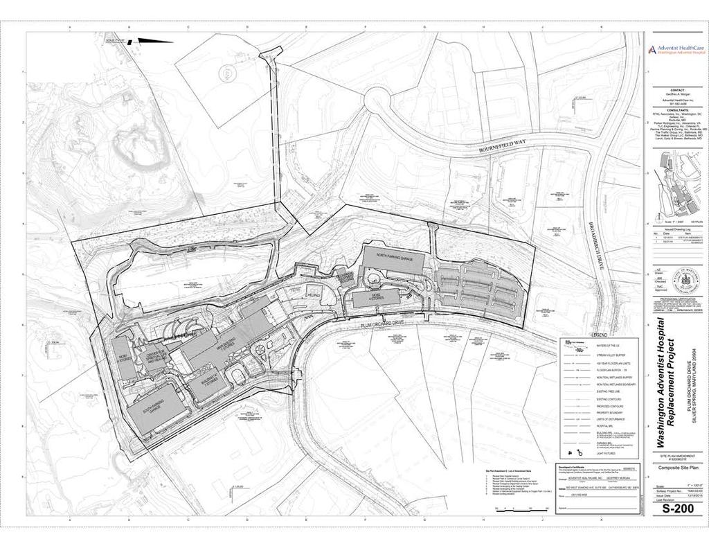
37 ATTACHMENT A
38
39
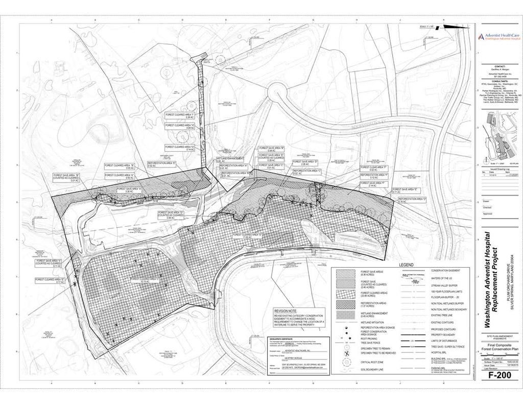
40 ATTACHMENT B
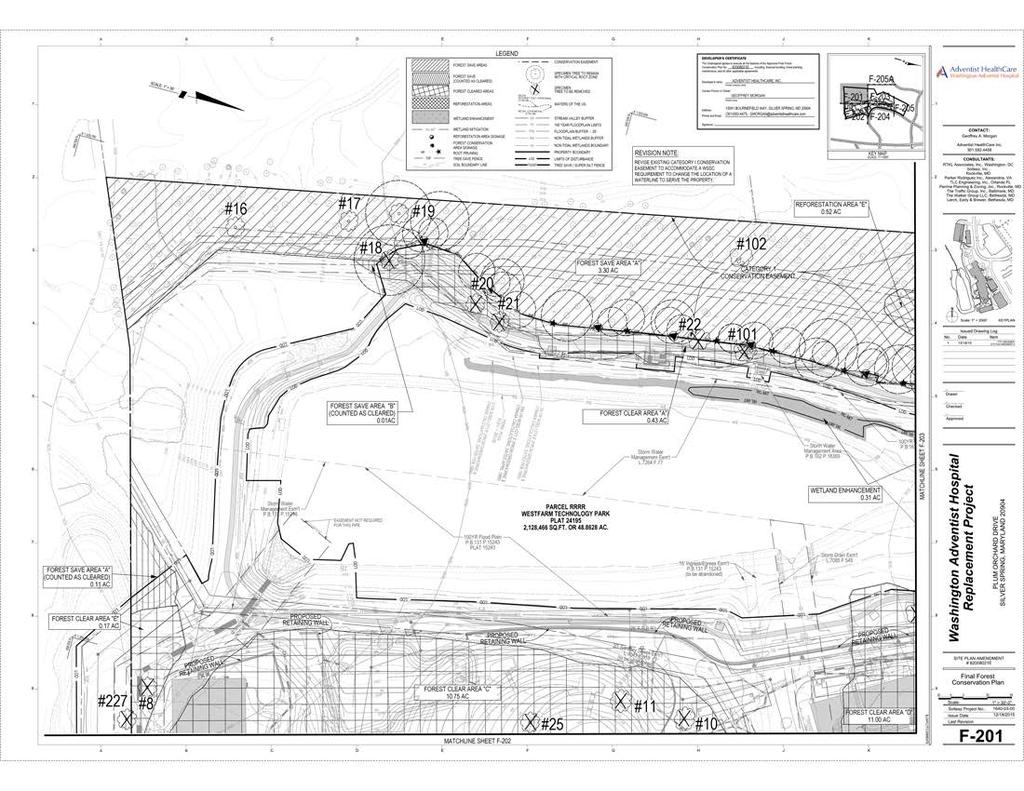
41
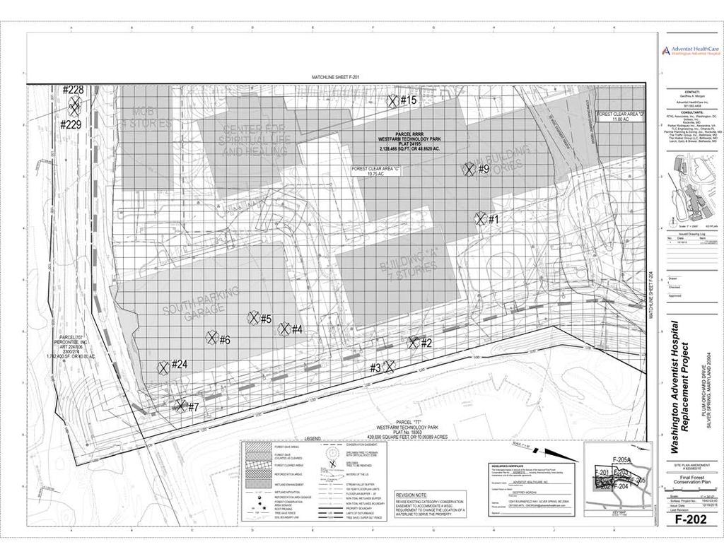
42
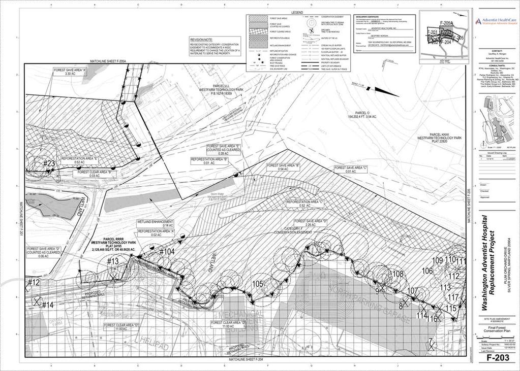
43
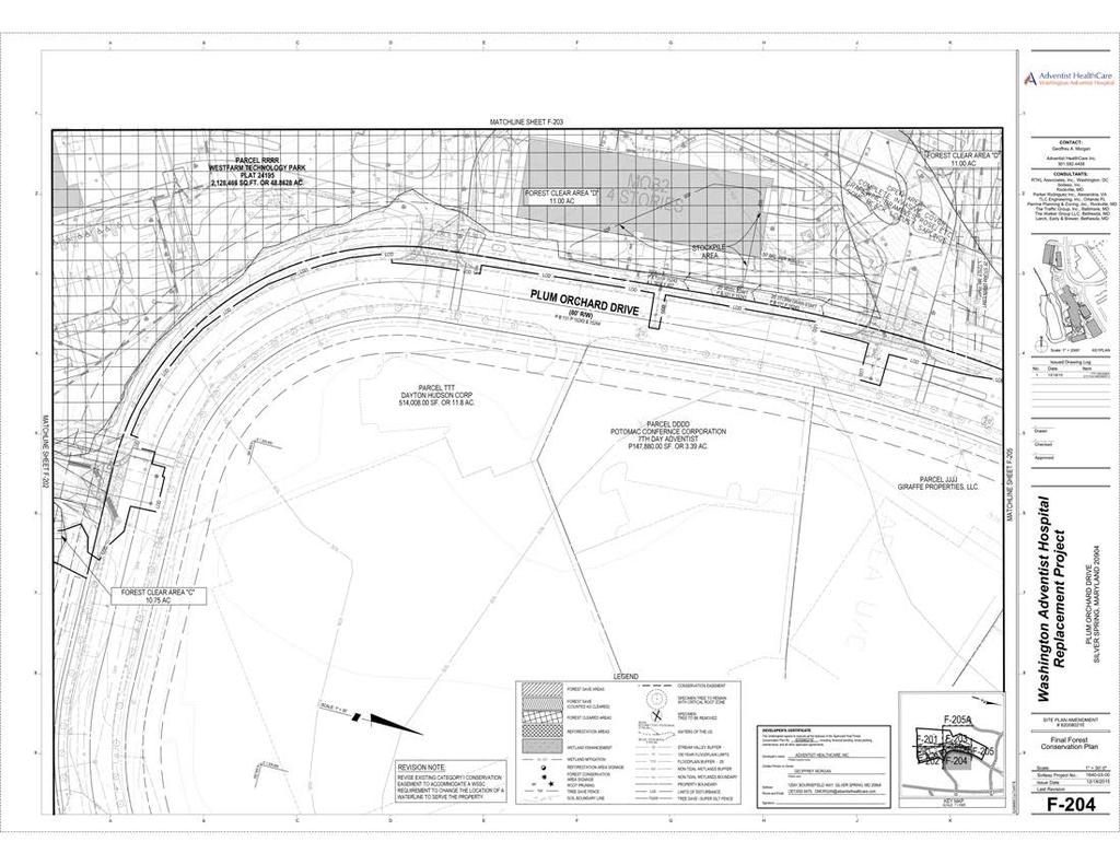
44
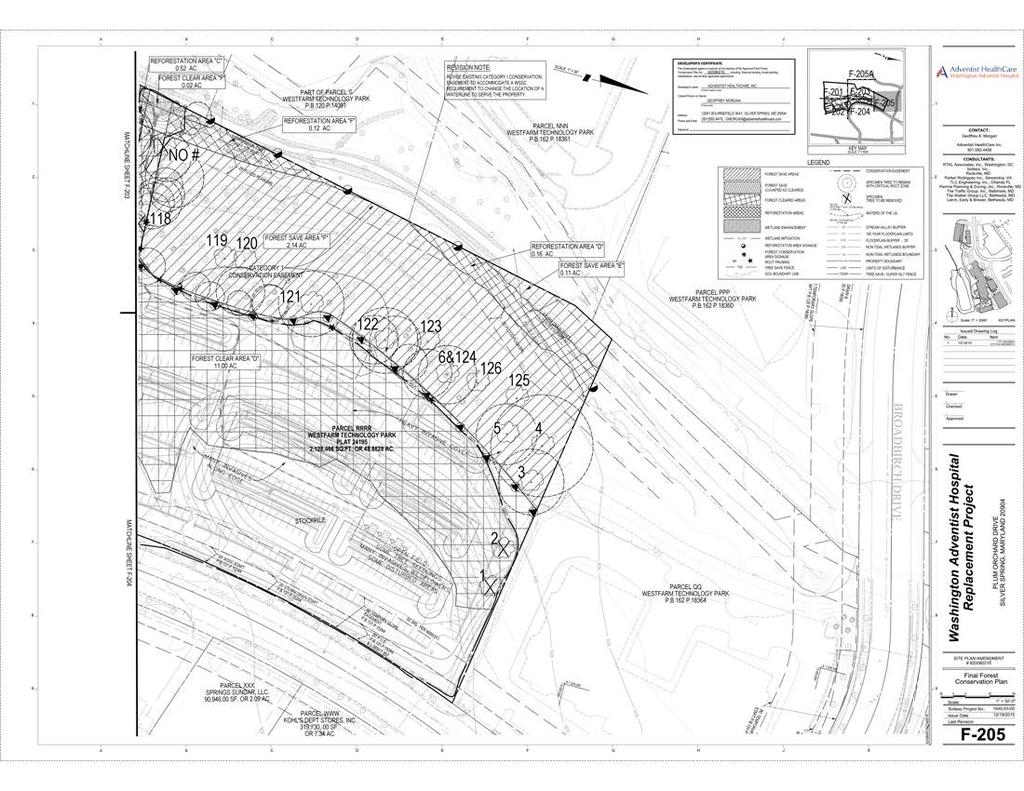
45
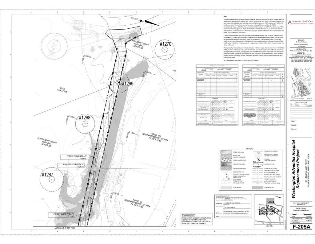
46
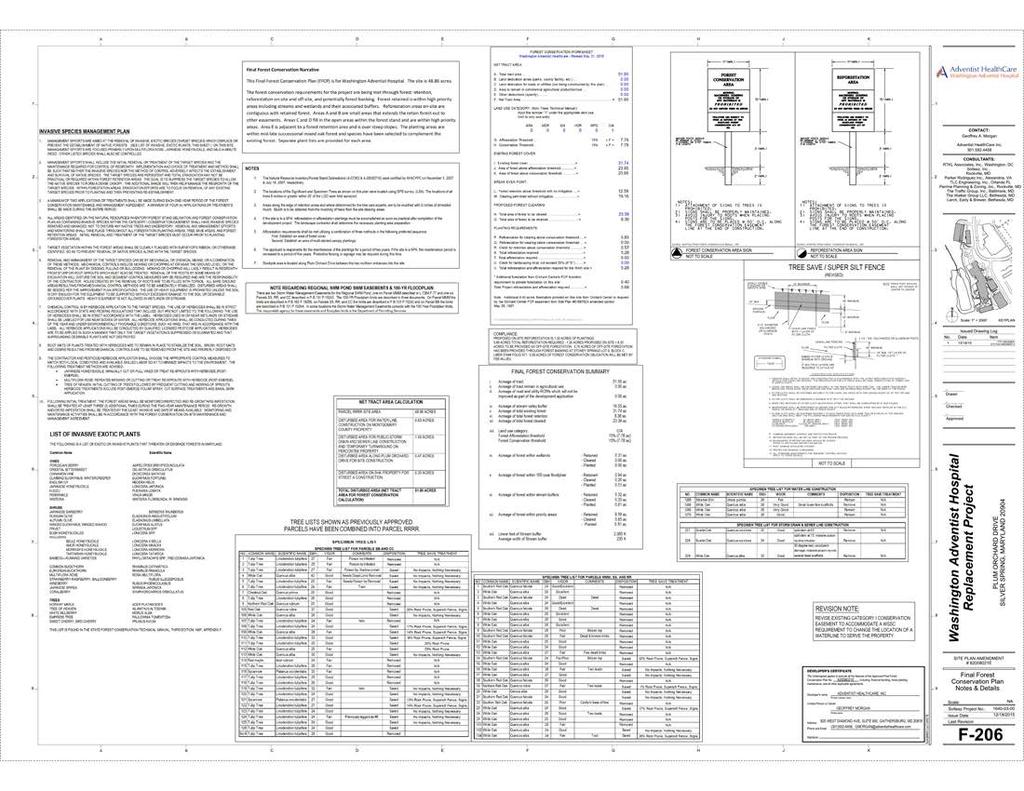
47

48
, Soltesz, Inc.")
49 ATTACHMENT C August 18, 2015 Amy Lindsey M-NCPPC Planning Area Georgia Avenue Silver Spring, MD Re: Washington Adventist Hospital Final Forest Conservation Plan Amendment - Variance Request Soltesz Project # Dear Ms. Lindsey, On behalf of Adventist Healthcare, Inc. (the Applicant ), Soltesz, Inc. is requesting a variance for the removal of one (1) tree 30 inches or greater in DBH, as required under Section 22A-21 of Montgomery County s Forest Conservation Law and 2010 revisions to the State Forest Conservation Law enacted by State Bill 666. Where it notes the variance pertains to Trees having a diameter measured at 4.5 feet above the ground of 30 inches diameter or 75% of the diameter of the current state champion tree of that species as designated by the department. The removal or impact of this tree is for the proposed public storm drain and sewer line relocation construction for Washington Adventist Hospital s main hospital building and adjacent ambulatory care building at the southwestern bend of Plum Orchard Drive. Project Information The subject property (Washington Adventist Hospital) is located in the White Oak Science Gateway Master Plan area and is within the Westfarm Technology Park. It is located directly on Plum Orchard Drive, approximately 400 feet west of Broadbirch Drive. The Percontee site, zoned CR, is located directly south of the property with future plans for a mixed-use development. On the east, opposite Plum Orchard Drive from the site is the loading area for several big box retail uses (Target, Kohl s and Pet Smart). To the south and east are parcels of the USPostal Service distribution facility, the SHA maintenance facility and a Marriott hotel. The property is zoned LSC (Life Sciences Center) Zone. The property is not located within a Special Protection Area. The proposed hospital construction is to facilitate the relocation of the Washington Adventist Hospital from Takoma Park to the White Oak Science Gateway Master Plan area. The main hospital building is organized in a campus-style setting surrounded by the ambulatory care building, medical office buildings and a parking structure to accommodate the uses. This project has previous approvals for Special Exception (S-2721), Certified Site Plan ( ) and four (4) Amendments ( A, B, C, & D). This amendment is to amend the approved Final Forest Conservation Plan ( D) to include the disturbed area for the proposed W SC water redundancy line across County property which connects to
50 W SC water tower on the west. The proposed changes are generated by the International Plumbing Code (IPC) requirement that all new hospitals need to have two water service pipes installed in order to ensure the safety and continuity of the hospital s lifesaving mission and protection of their patients. The proposed water line alignment was recommended by W SC. During W SC s Hydraulic Planning Analysis, the only true redundant water supply in the Hospital project area is a connection to the water main feeding the existing water tower on the W SC property to the west of the hospital site. In order to build this water line, a small portion of the existing Category I forest conservation easement (680 square feet) need to be revised. No building footprint, elevations, height, density, use, parking calculations, or impervious areas are proposed to change for this amendment. Also included in the amendment is a revised site tract area calculation to include all the off-site disturbed areas for this project, which brought the total tract area to acres instead of acres of the parcel RRRR site area. This total tract area includes: acres of Parcel RRRR site area, 0.72 acres of disturbed area for water line construction on Montgomery County property, 1.32 acres of disturbed area for public storm drain and sewer line construction on Percontee property,0.49 acres of disturbed area along Plum Orchard Drive for Site construction, and 0.3 acres of disturbed areas on adjacent SHA property for street A construction. Soltesz conducted site investigation on July 31, 2015 for the disturbed areas included for this Final Forest Conservation Plan Amendment and there is one (1) specimen tree in the storm drain and sewer line construction area with DBH above 30 proposed to be removed. The tree identified in this variance request for removal is shown on the amended Final Forest Conservation Plan. The tree to be removed is located within the limits of disturbance. Tree for Removal Listed below is the tree identified for impact on the Final Forest Conservation Plan Amendment. Existing /Significan/Specimen CRZ CRZ IMPACT % of Proposed CODE Tree DBH (sf) (sf) Impact Status Specimen 229 White Oak / Quercus alba 32 7,238 7, % REMOVE YES Additional Application Requirements Per Montgomery County s Forest Conservation Law Section 22A-21(b) of the Application Requirements states that the applicant must: (1) describe the special conditions peculiar to the property which would cause the unwarranted hardship; (2) describe how enforcement of these rules will deprive the landowner of rights commonly enjoyed by others in similar areas; (3) verify that state water quality standards will not be violated or that a measurable degradation in water quality will not occur as a result of the grantingof the variance; and (4) Provided any other information appropriate to support the request. \\MCP-PDOX-PRO-A\UserFilesSource\4071 \1 9294\1 0-VAR E.docx\1 0-VAR E.docx Page 2 of 4
51 Pursuant to: Item (1) describe the special conditions peculiar to the property which would cause the unwarranted hardship; and Item (2) describe how enforcement of these rules will deprive the landowner of rights commonly enjoyed by others in similar areas : The land use and proposed density conform to the White Oak Science Gateway Master Plan designation. The property is in LSC Zone and it allows for life science related development. The project went through multiple review through Montgomery County and received approvals as previously stated. The specimen tree to be impacted is within the disturbed area for proposed relocation of public storm drain and sewer line on Percontee property on the south. There is no existing Forest Conservation easements that encumber the proposed disturbed area. Without removing this specimen tree, the proposed storm drain and sewer line construction, which are both part of previous approved Certified Site Plan, can t be constructed. The approved hospital construction can t be realized without this storm drain pipe and sewer line relocation. The hospital went through multiple County review process and received approvals. If the request is denied, it will cause unwarranted hardship to the hospital. As previously stated, the intent to relocate the public storm drain and sewer line in the proposed disturbed area has been previously approved by the Planning Board. Enforcement of a prohibition of removing the specimen tree would deprive the applicant of the rights commonly enjoyed by others who are in similar situation as the subject property. Pursuant to (3) verify that state water quality standards will not be violated or that a measurable degradation in water quality will not occur as a result of the grantingof the variance The tree proposed for removal is not directly connected to any streams, or part of a riparian buffer system. The proposed stormwater management plan for the new hospital buildings makes provision for stormwater runoff at the site. SWM calculations show that a measurable degradation in water quality will not occur as a result of the granting of the variance. Pursuant to (4) Provided any other information appropriate to support the request. As stated previously, the approved plans for this site has called for public storm drain and sewer line in the location where the tree is proposed for removal. No other specimen trees with 30 or bigger DBH within the forest conservation plan area will be impacted. Minimum criteria for Variance As further basis for its variance request, the applicant can demonstrate that it meets the Section 22A-21(d) Minimum criteria, which states that a variance must not be granted if granting the request: (1) Will confer on the applicant a special privilege that would be denied to other applicants; (2) Is based on conditions or circumstances which are the result of actions by the applicant; \\MCP-PDOX-PRO-A\UserFilesSource\4071 \1 9294\1 0-VAR E.docx\1 0-VAR E.docx Page 3 of 4
52 (3) Arises from a condition relatingto land or buildinguse, either permitted or nonconforming, on a neighboringproperty; or (4) Will violate State water quality standards or cause measurable degradation in water quality Pursuant to (1) Will confer on the applicant a special privilege that would be denied to other applicants. The use of this site for a hospital is a permitted and Master Plan recommended use and will operate in a manner consistent with that of surrounding developments in the area and in Montgomery County. The storm drain and sewer line construction is part of the hospital construction. As such, this is not a special privilege to be conferred on the applicant. Pursuant to (2) Is based on conditions or circumstances which are the result of actions by the applicant; and (3) Arises from a condition relatingto land or buildinguse, either permitted or nonconforming, on a neighboringproperty The applicant has taken no actions leading to the conditions or circumstances that are the subject of this variance request. Furthermore, the surrounding land uses do not have any inherent characteristics that have created this particular need for a variance. Pursuant to (4) Will violate State water quality standards or cause measurable degradation in water quality The applicant cites the reasoning in the previous response to requirement 22A-21 (b)(3), and restates its belief that granting this variance request will not violate State water quality standards or cause measurable degradation in State water quality standards. For these reasons listed above, we believe it is appropriate to grant this request for a variance. Should you have any questions or require additional information, please do not hesitate to contact me. Sincerely, SOLTESZ, INC. Amy Zou, RLA, ASLA Senior Landscape Architect cc: \\MCP-PDOX-PRO-A\UserFilesSource\4071 \1 9294\1 0-VAR E.docx\1 0-VAR E.docx Page 4 of 4


 of the Forest Conservation Law states that a variance must not be granted if granting the request: 1.")
53 ATTACHMENT D DEPARTMENT OF ENVIRONMENTAL PROTECTION Isiah Leggett County Executive Lisa Feldt Director May 12, 2016 Casey Anderson, Chair Montgomery County Planning Board Maryland National Capital Park & Planning Commission 8787 Georgia Avenue Silver Spring, Maryland RE: Washington Adventist Hospital, eplan E, Site Plan amendment application received on 2/8/2016 Dear Mr. Anderson: All applications for a variance from the requirements of Chapter 22A of the County Code submitted after October 1, 2009 are subject to Section 22A-12(b)(3). Accordingly, given that the application for the above referenced request was submitted after that date and must comply with Chapter 22A, and the Montgomery County Planning Department ( Planning Department ) has completed all review required under applicable law, I am providing the following recommendation pertaining to this request for a variance for all disturbances with the exception of any activity within the critical root zone of tree number Section 22A-21(d) of the Forest Conservation Law states that a variance must not be granted if granting the request: 1. Will confer on the applicant a special privilege that would be denied to other applicants; 2. Is based on conditions or circumstances which are the result of the actions by the applicant; 3. Arises from a condition relating to land or building use, either permitted or nonconforming, on a neighboring property; or 4. Will violate State water quality standards or cause measurable degradation in water quality. Applying the above conditions to the plan submitted by the applicant, I make the following findings as the result of my review: 1. The granting of a variance in this case would not confer a special privilege on this applicant that would be denied other applicants as long as the same criteria are applied in each case. Therefore, the variance can be granted under this criterion. 2. Based on a discussion on March 19, 2010 between representatives of the County, the Planning Department, and the Maryland Department of Natural Resources Forest Service, the disturbance of trees, or other vegetation, as a result of development activity is not, in and of itself, interpreted 255 Rockville Pike, Suite 120 Rockville, Maryland FAX montgomerycountymd.gov/ TTY
54 Casey Anderson May 12, 2016 Page 2 as a condition or circumstance that is the result of the actions by the applicant. Therefore, the variance can be granted under this criterion, as long as appropriate mitigation is provided for the resources disturbed. 3. The disturbance of trees, or other vegetation, by the applicant does not arise from a condition relating to land or building use, either permitted or nonconforming, on a neighboring property. Therefore, the variance can be granted under this criterion. 4. The disturbance of trees, or other vegetation, by the applicant will not result in a violation of State water quality standards or cause measurable degradation in water quality. Therefore, the variance can be granted under this criterion. Therefore, I recommend a finding by the Planning Board that this applicant qualifies for a variance conditioned upon the applicant mitigating for the loss of resources due to removal or disturbance to trees, and other vegetation, subject to the law based on the limits of disturbance (LOD) recommended during the review by the Planning Department. In the case of removal, the entire area of the critical root zone (CRZ) should be included in mitigation calculations regardless of the location of the CRZ (i.e., even that portion of the CRZ located on an adjacent property). When trees are disturbed, any area within the CRZ where the roots are severed, compacted, etc., such that the roots are not functioning as they were before the disturbance must be mitigated. Exceptions should not be allowed for trees in poor or hazardous condition because the loss of CRZ eliminates the future potential of the area to support a tree or provide stormwater management. Tree protection techniques implemented according to industry standards, such as trimming branches or installing temporary mulch mats to limit soil compaction during construction without permanently reducing the critical root zone, are acceptable mitigation to limit disturbance. Techniques such as root pruning should be used to improve survival rates of impacted trees but they should not be considered mitigation for the permanent loss of critical root zone. I recommend requiring mitigation based on the number of square feet of the critical root zone lost or disturbed. The mitigation can be met using any currently acceptable method under Chapter 22A of the Montgomery County Code. In the event that minor revisions to the impacts to trees subject to variance provisions are approved by the Planning Department, the mitigation requirements outlined above should apply to the removal or disturbance to the CRZ of all trees subject to the law as a result of the revised LOD. If you have any questions, please do not hesitate to contact me directly. Sincerely, Laura Miller County Arborist cc: Amy Lindsey, Planner Coordinator
55
56
57
58
59
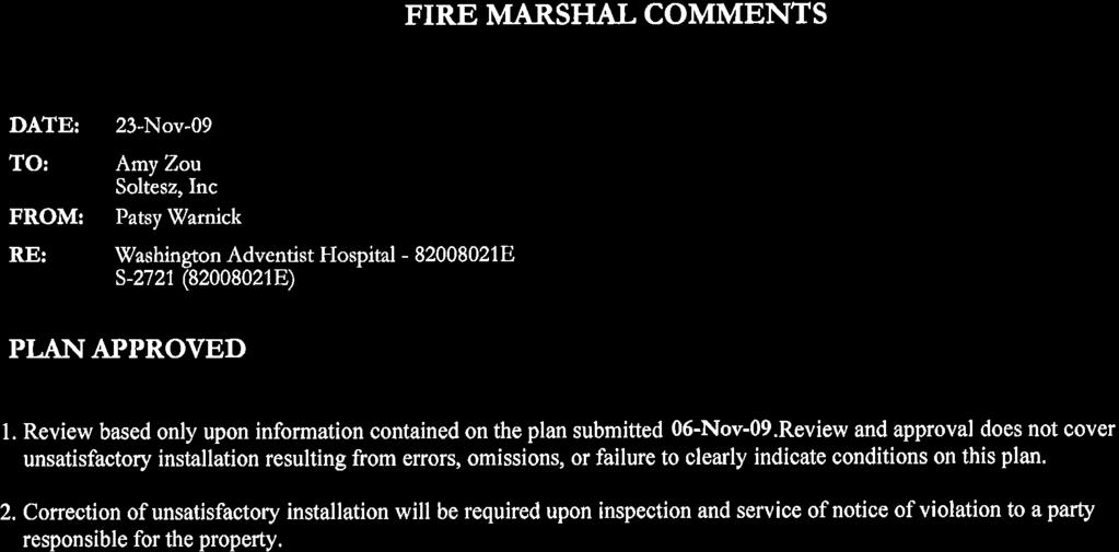
60
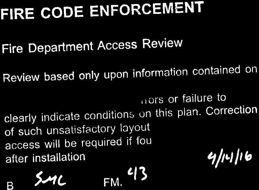


61
62
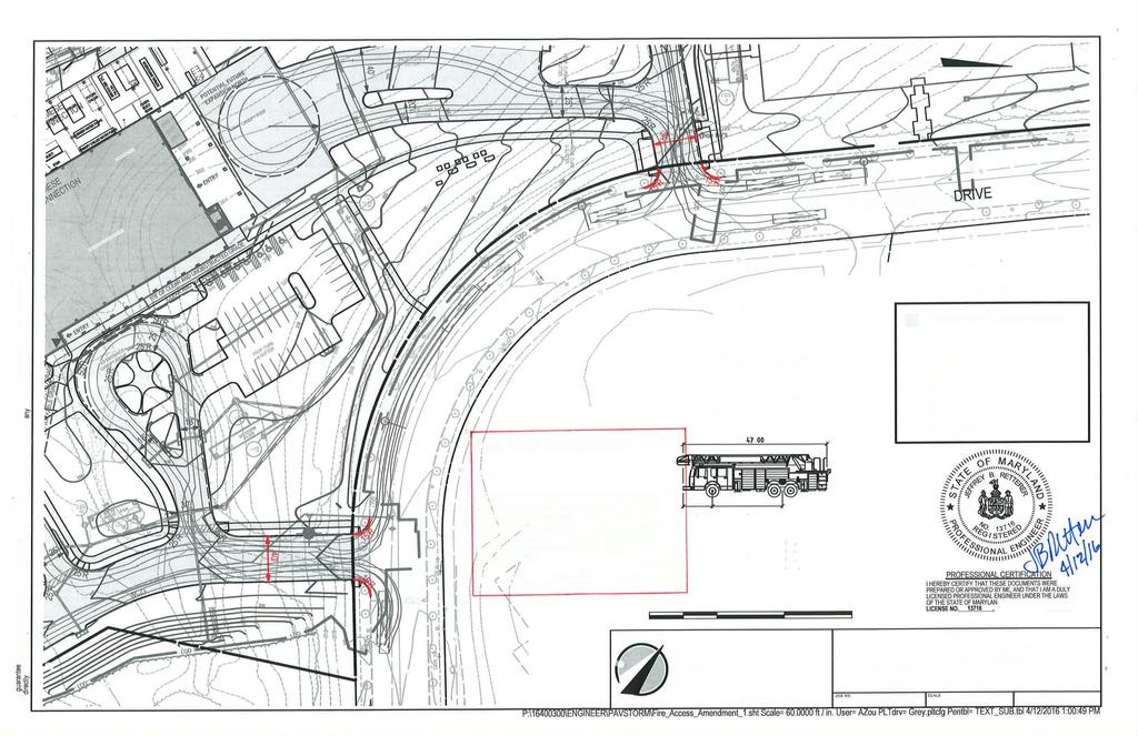


63
64 ATTACHMENT E BOARD OF APPEALS for MONTGOMERY COUNTY Stella B. Werner Council Office Building 100 Maryland Avenue Rockville, Maryland (240) Case No. S-2721 PETITION OF ADVENTIST HEALTHCARE, INCORPORATED BY GEOFFREY A. MORGAN OPINION OF THE BOARD (Opinion Adopted September 10, 2008) (Effective Date of Opinion: October 27, 2008) Case No. S-2721 is an application for a special exception, pursuant to Section 59-G of the Zoning Ordinance, to permit the relocation of Washington Adventist Hospital from its current location in Takoma Park to a new site in West Farm Technology Park. The Hearing Examiner for Montgomery County held a hearing on the application on May 5, 2008, closed the record in the case on August 15, 2008, and on August 19, 2008 issued a Report and Recommendation for approval of the special exception. The subject property is Lot BB, CC, RR, SS and MMM, Westfarm Technology Park Subdivision, located at Plum Orchard Drive, Silver Spring, Maryland, 20904, in the I-1 and I-3 Zone. Decision of the Board: Special exception Granted, subject to The conditions enumerated below. The Board of Appeals considered the Hearing Examiner s Report and Recommendation at its Worksession on September 10, The Board commends the Applicant for a thorough and well thought out application. After careful consideration and review of the record, and with slight revisions to Conditions three, eight, eleven and twelve, the Board adopts the Report and Recommendation, and grants the special exception subject to the following conditions: 1. Petitioner must comply with the conditions of the Preliminary Forest Conservation Plan (PFCP) and any Final Forest Conservation Plan approved by the Planning Board. The PFCP conditions include: a. Revise the PFCP to include the following:
65 Case No. S-2721 Page 2 i. Avoid or minimize disturbance of environmental buffers, including wetlands. Revisions must be consistent with the two revised site plans (entitled North Parking Garage and MOB2 Plan Revision and Main Hospital Entry Site Plan Revision ) and alternate waterline plan (entitled Alternate Waterline Location Plan ). ii. Show proposed limits of disturbance that avoid environmental buffers and that are realistically located with respect to proposed structures. b. Category I conservation easement must be placed over forest retention areas, forest planting areas, and that portion of the environmental buffer that does not include a County stormwater management easement. c. Category I conservation easement must be shown on record plats. 2. Petitioner must comply with Montgomery County green building requirements Revise all forest conservation plans to avoid or minimize disturbance of environmental buffers, including wetlands, consistent with the two revised site plans and waterline alignment plan (entitled North Parking Garage and MOB2 Plan Revision and Main Hospital Entry Site Plan Revision and the Alternate Waterline Alignment plan received March 27, 2008). 4. Coordinate with MNCPPC and County DPS to implement measures to maintain water flow to the forested wetland and its buffer near the northern parking garage. Cleaner water discharges from rooftops, green roofs, etc., should be examined to replace surface and groundwater flows lost to upstream development. 5. To ensure adequacy of public facilities, Petitioner must satisfy the following conditions: 2 a. Limit development on the property as part of this special exception and future Site Plan for the property to a total built density of 803,570 square-feet, including a main hospital building, an ambulatory care building, a faith center, two medical office buildings, two parking structures, and a helipad. No additional uses may be permitted on the property unless the special exception is modified within the APF validity period. b. Implement road improvements and other installations required in Conditions c, g, h, i, j and k as described in the schedule below. The Applicant must complete and submit to Montgomery County Department of Transportation (DOT) conceptual designs for the road improvements and other installations, 1 This conditions differs from Condition #2 proposed by the Planning Board because that condition called for Petitioner to revise its special exception site plan relating to parking, and Petitioner has already done so in filing its amended Composite Special Exception Site Plan (Exhibit 161(e)). 2 The conditions listed are those recommended jointly by Technical Staff and DOT (Exhibit 176) following the hearing. They preserve the intent of the Planning Board recommendations, but have been updated to include modifications sought by DOT after the hearing.
66 Case No. S-2721 Page 3 including signal warrant studies, at least 45 days in advance of the Planning Board s public hearing on the Applicant s Site Plan. Where possible, the Applicant may meet the provision of required turn lanes in some cases by restriping existing paving. Final design drawings for the road improvements and other installations must be submitted to all relevant permitting agencies prior to the release of building permits for the hospital. At the time of submission of completed designs to permitting agencies, the Applicant must post one or more surety or cash bonds in the amount estimated by its engineers (and approved by the Planning Board staff) that represent the cost of construction of such road improvements and other installations. Bonds must be posted with DOT or if DOT does not accept them, with the Planning Board on an interim basis to be released to the Applicant at such time as the permitting agencies accept bonds for equivalent purposes. Upon issuance of permits, the Applicant must proceed diligently with construction of the road improvements and other installation. The Applicant must provide notice to Planning Board staff that final inspections for the use and occupancy permit have begun. Prior to the issuance of any use and occupancy permit for the hospital and/or any other on-site building, all road improvements and other installations must be substantially complete and open to traffic as determined by Planning Board staff. c. Prior to issuance of the building construction permit (including structural, electrical, plumbing, mechanical, etc. components) for the hospital and/or any other on-site building, the Applicant will be required to have obtained any necessary rights-of-way and/or easements, along with Executive Branch plans approval, and posted bonds for the construction drawings of improvements (including but not limited to intersection widenings, DOTapproved traffic signals, traffic control signs and markings, etc.) to be constructed within the public right-of-way. Additionally, if any of the road improvements identified in these conditions either are now, or in the future become, obligations of other development projects, applicants of other development projects may participate on a prorata basis in the joint funding of such improvements. Basis of participation on a pro-rata basis is the sum of total peak hour trips generated by the subject development relevant to the particular improvement over the sum of total peak hour trips generated by all developments required by the Planning Board to participate in the construction of the particular improvement. The road improvements must include: i) At the Cherry Hill Road/Broad Birch Drive/Calverton Boulevard intersection: Provide, along Cherry Hill Road, a southbound right-turn lane to westbound Broad Birch Drive.
67 Case No. S-2721 Page 4 Provide, along Cherry Hill Road, a second northbound left-turn lane to westbound Broad Birch Drive. Provide, along Broad Birch Drive, improvements that result in two eastbound left turn lanes to northbound Cherry Hill Road, a through lane to eastbound Calverton Boulevard, and a right-turn lane to southbound Cherry Hill Road. Upgrade the existing traffic signal system at the intersection as necessary. ii) At the Cherry Hill Road/Plum Orchard Drive/Clover Patch Drive intersection: Provide, along Cherry Hill Road, a southbound right-turn lane to westbound Plum Orchard Drive. Provide, along Cherry Hill Road, a second northbound left-turn lane to westbound Plum Orchard Drive. Upgrade the existing traffic signal system at the intersection as necessary. iii) At the Broad Birch Drive/Plum Orchard Drive intersection: Provide a new traffic signal when warranted and approved by DOT. Provide, along Broad Birch Drive, a separate eastbound right-turn lane to southbound Plum Orchard Drive. Provide, along Broad Birch Drive, a separate westbound left-turn lane to southbound Plum Orchard Drive. iv) At the Tech Road/Broad Birch Drive intersection: Provide a new traffic signal when warranted and approved by DOT. Reconfigure southbound Tech Road approach to Broad Birch Drive from a through lane and a through-left lane to provide a through-left lane (to southbound Tech Road and eastbound Broad Birch Drive) and a left-turn lane (to eastbound Broad Birch Drive). Reconfigure northbound Tech Road approach to Broad Birch Drive from a through-right lane and a through lane to provide a right-turn lane (to eastbound Broad Birch Drive) and a through lane (to northbound Tech Road). Reconfigure westbound Broad Birch Drive approach to Tech Road from a right-turn lane and a left-turn lane to provide a right-turn lane (to northbound Tech Road) and a left-right lane (to southbound Tech Road and northbound Tech Road). v) At the Plum Orchard Drive/proposed Southern (Main) Hospital Entrance Driveway/Private Street A: Provide a new traffic signal when warranted and approved by DOT.
68 Case No. S-2721 Page 5 Provide, along Plum Orchard Drive, a separate northbound left-turn lane into the proposed hospital driveway if approved by DOT under the Signs and Markings Plan. Provide along Plum Orchard Drive, a separate southbound right-turn lane into the proposed hospital driveway if approved by DOT under the Signs and Markings Plan. Provide, along the proposed hospital driveway, separate outbound right-turn and left-turn lanes (to southbound and northbound Plum Orchard Drive respectively). vi) At the Plum Orchard Drive/Proposed Northern Hospital Entrance Driveway: Provide, along Plum Orchard Drive, a separate northbound left-turn lane into the proposed hospital driveway if approved by DOT under the Signs and Markings Plan. Provide, along Plum Orchard Drive, a separate southbound right-turn lane into the proposed hospital driveway if approved by DOT under the Signs and Markings Plan. Provide, along the proposed hospital driveway, separate outbound right-turn and left-turn lanes (to southbound and northbound Plum Orchard Drive respectively). The aforementioned lane use modifications are subject to DOT approval. If DOT finds the modification(s) is not appropriate when the applicant applies for the first building construction permit, the Applicant shall prepare a cost estimate for the measures necessary to implement the modification(s), for approval by DOT. Applicant shall pay DOT the approved amount(s); DOT will be responsible for implementing the modification(s) at such time as it determines them to be operationally appropriate. Prior to approval of the roadway construction drawings, Applicant shall provide documentation acceptable to the Executive Branch review agencies that satisfactorily demonstrates the proposed intersection improvements will be adequate to accommodate the turning movements of WB-50 trucks and emergency response vehicles. The aforementioned intersection improvements may be expanded to accommodate these turning movement requirements. If required as a result of Executive Branch approval of the roadway construction (and/or related Signs and Markings Plan), Applicant shall re-stripe Plum Orchard Road. Applicant shall also construct pedestrian refuge islands if approved under that review. Applicant will be required to relocate any existing underground utilities, at its sole expense, if those utilities will be located within the proposed
69 Case No. S-2721 Page 6 widened roadway pavement or in conflict with the relocated enclosed storm drain system. d. Provide hospital-oriented employee shuttle(s) for main shift employees to and from the Metrorail system for a total of 10 years from the date the hospital opens to the public or until an earlier date if the Planning Board determines that area public transit service adequately meets the needs of these employees. The details of the shuttle operation (routes, locations, headways, etc.) must be determined at the time of Site Plan. Logistics related to the operation of the employee shuttle(s) must be in place prior to release of the first occupancy permit for the hospital and/or any other on-site building. The employee shuttle service must start operation at least a week prior to formal opening of the proposed hospital. e. The applicant shall submit a Memorandum of Understanding (MOU) to implement a Transportation Management Program (TMP) for the proposed hospital at the time of Site Plan. The applicant, the Maryland-National Capital Park and Planning Commission and the Department of Transportation shall each be signatory parties on the MOU for the TMP for this project. The MOU and the TMP must be finalized and entered into prior to the release of building permits for the proposed hospital and/or any other on-site building. The TMP must designate a Transportation Coordinator at the hospital. The TMP must also include a periodic reporting mechanism such as a semiannual performance review of the program by DOT or the Planning Board staff, as well as periodic reports to a Community Liaison Committee that may include members of the local community, area businesses and institutions, and Citizen Advisory Committees. In addition, the program must consider transit subsidies to employees, establishment of creative transportation accessibility options for employees, patients and visitors, installation of transportation/transit information display areas or kiosks in prominent locations throughout the hospital for employees, patients and visitors, and joint operation of local non-employee circulator shuttles in the area with other businesses/uses. f. Provide adequate internal connecting roadways, sidewalks, handicapped ramps and crosswalks to ensure safe and efficient vehicular/pedestrian connections. The applicant must submit a vehicular/non-vehicular circulation plan for the campus at the time of Site Plan for review by Transportation Planning staff, DOT, and the Montgomery County Department of Permitting Services (DPS). g. Construct a multi-bus pulloff facility(s) with canopy structure(s) in the vicinity of the hospital site. This is in lieu of the Planning Board s recommendations set forth in Section 5(g-j) of the Planning Board Recommendations for various bus shelters in the vicinity of the hospital. The location and conceptual design details for the facility(s) shall be resolved at the Site Plan
70 Case No. S-2721 Page 7 stage. To the extent the multi-bus pulloff facility(s) is not equivalent to the Planning Board s recommendations, the Applicant will provide additional bus shelters or other equivalent amenity. These equivalency issues will be resolved at the time of Site Plan. h. Provide, with approval from DOT, pedestrian countdown/aps signals at the Cherry Hill Road intersections with Broad Birch Drive/Calverton Boulevard and Plum Orchard Drive/Clover Patch Drive. The pedestrian countdown/aps signals must be installed at these intersections under permit in conjunction with the aforementioned intersection improvements. In the event the pedestrian countdown/aps signals are not approved by DOT, the applicant may substitute these with other available non-auto facilities of equivalent or greater mitigation value. i. Provide, with approval from DOT, pedestrian countdown/aps signals at the Plum Orchard Drive intersection with the proposed Southern Hospital Entrance Driveway/Private Street A (main hospital entrance) if the proposed traffic signal at this intersection is approved by DOT. The pedestrian countdown/aps signals must be installed at this intersection under permit in conjunction with the aforementioned intersection improvements. In the event the pedestrian countdown/aps signals are not approved by DOT, the applicant may substitute these with other available non-auto facilities of equivalent or greater mitigation value. j. Relocate any existing pedestrian countdown and accessible pedestrian signals, at Applicant s sole expense, as part of any widenings of existing signalized intersections. In the event the County has already installed pedestrian countdown and accessible pedestrian signals at intersection(s) required of the Applicant, the Applicant obtain necessary plan approvals and posted bonds to install such signals at other nearby signalized intersection(s) prior to issuance of the building construction permit (including structural, electrical, plumbing, mechanical, etc. components) for the hospital and/or any other on-site building. k. Prior to issuance of the building permit for the hospital and/or any other onsite building, Applicant shall pay the County $40,000 for the future installation of two real-time transit information signs to be installed in the vicinity of the site. Applicant will be responsible for installing the necessary equipment, conduit, electrical connections, etc. to allow the County to install one real-time transit information sign each in the hospital and in the canopy structure once that program becomes operational. Applicant to grant necessary permission to allow County staff to access and maintain the realtime transit information sign, if one is installed within the hospital as proposed. l. Provide bike lockers and bike racks on the hospital campus as required by the Montgomery County Code. The bike locker and bike rack locations must be determined and finalized at the time of Site Plan.
71 Case No. S-2721 Page 8 6. The Petitioner shall be bound by all of its testimony and exhibits of record, and by the testimony of its witnesses and representations of counsel to the extent that such evidence and representations are identified in the Hearing Examiner s Report and Recommendation and in the opinion of the Board. 7. Petitioner may employ approximately 2,000 employees to serve staffing requirements for approximately 1,300 full-time equivalent employees. Approximately 500 additional employees will work in the two medical office buildings ( MOBs ) on the Campus. 8. Petitioner s hours of operation are 24 hours per day, seven days a week. Working hours for staff will be arranged in eight to ten different shifts, which shall be coordinated in the Transportation Management Plan to minimize traffic impacts, consistent with hospital needs. 9. The hospital campus must be developed in accordance with the final site, landscape, architectural, engineering and lighting plans submitted prior to closure of the record, unless changed at site plan review. This special exception is conditioned upon approval at site plan review. If the submitted plans and/or specifications for this project change at site plan review in any material way, Petitioner must timely apply to the Board of Appeals for an administrative modification of the special exception to substitute the revised plans and specifications. 10. All signs placed on the property must meet the requirements of Zoning Ordinance Article 59-F in terms of number, location, size and illumination, or appropriate variances obtained therefore. Sign permits must be obtained, and copies of those permits should be filed with the Board of Appeals prior to posting. 11. Petitioner shall maintain a log of helicopter flights to and from the hospital to insure that it is being used only for emergency purposes, which is the basis for its permitted use status under Zoning Ordinance 59-A-6.6. Emergency in this context shall be broadly construed to include all flights deemed medically necessary for individual patients. The log shall indicate at least the date and time of flight, the destination and origination points, the operator of the helicopter, and the reason for the flight (Patient names or identification numbers, if included, shall be handled so as to protect patient privacy rights). The log shall be made available for review by the Department of Permitting Services upon request. 12. Petitioner shall review the helicopter flight paths and determine which flight paths will minimize disturbance to the surrounding community. To the extent that the hospital has control over the flight paths used, it shall establish a preference, consistent with safety and operational concerns, for using the flight paths which minimize disturbance to the surrounding community. If Petitioner does not control the flight paths, then it shall consult with the appropriate controlling authority to encourage use of the flight paths which minimize disturbance to the surrounding community, without adversely impacting safety and operational considerations.
72 Case No. S-2721 Page 9 The results of Petitioner s review shall be submitted to the Board within six months after the relocated helipad becomes operational. 13. The requirement of Zoning Ordinance 59-E-1.3(a) that a parking facility be located within a 500-foot walking distance of the establishment served is waived so that the North Parking Garage may be located at a walking distance of up to 560 feet from the Main Building of the Hospital. Use of the North Parking Garage to access the Main Hospital Building should be restricted to hospital staff, in light of this waiver. This restriction does not apply to users of Medical Office Building 2 (MOB2), which is located practically adjacent to the North Parking Garage. 14. Petitioner must create a Community Liaison Committee (CLC) to discuss and address issues of concern to Petitioner and/or the community, especially those within sight and sound of the new property. The CLC may be established under the auspices of the Fairland Master Plan Citizens Advisory Committee, if that Group is amenable, or it may exist as an independent entity. The CLC shall consist of Petitioner s representative and representatives from the Fairland Master Plan Citizens Advisory Committee, the Calverton Citizens Association, Riderwood Village, West Farm Homeowners Association, Greater Colesville Citizens Association, Tamarac Triangle Citizens Association, Paint Branch/Powder Mill Estates Citizens Association, and any other nearby civic association or homeowners association wishing to participate. The People's Counsel will serve as an ex officio member of the CLC. The CLC is intended to provide a means and mechanism for communication and interaction between the hospital and its neighbors. The CLC must have an initial organizational meeting prior to the start of construction, and meet three times a year until construction is completed. Once the hospital is open to the public, the CLC must thereafter meet at least two times each year. Minutes of meetings must be taken and distributed, and the CLC must prepare an annual report to be submitted to the Board of Appeals. There will be no requirements for a quorum, voting, or specific attendance. Community groups must be invited and notified, but they may attend at their own election and based upon their own degree of interest. 15. Petitioner must obtain and satisfy the requirements of all licenses and permits, including but not limited to building permits and use and occupancy permits, necessary to occupy the special exception premises and operate the special exception as granted herein. Petitioner shall at all times ensure that the special exception use and premises comply with all applicable codes (including but not limited to building, life safety and handicapped accessibility requirements), regulations, directives and other governmental requirements. On a motion by David K. Perdue, seconded by Catherine G. Titus, Vice-Chair, with Wendell M. Holloway and Allison Ishihara Fultz, Chair, in agreement, the Board adopted the following Resolution: BE IT RESOLVED by the Board of Appeals for Montgomery County, Maryland that the opinion stated above is adopted as the Resolution required by law as its decision on the above-entitled petition.
73 Case No. S-2721 Page 10 Allison Ishihara Fultz Chair, Montgomery County Board of Appeals Entered in the Opinion Book of the Board of Appeals for Montgomery County, Maryland this 27th day of October, Katherine Freeman Executive Director NOTE: Any request for rehearing or reconsideration must be filed within fifteen (15) days after the date the Opinion is mailed and entered in the Opinion Book (See Section 59-A-4.63 of the County Code). Please see the Board s Rules of Procedure for specific instructions for requesting reconsideration. Any decision by the County Board of Appeals may, within thirty (30) days after the decision is rendered, be appealed by any person aggrieved by the decision of the Board and a party to the proceeding before it, to the Circuit Court for Montgomery County, in accordance with the Maryland Rules of Procedure. It is each party s responsibility to participate in the Circuit Court action to protect their respective interests. In short, as a party you have a right to protect your interests in this matter by participating in the Circuit Court proceedings, and this right is unaffected by any participation by the County.
74
75
76
77
78
79
80
81 ATTACHMENT F
82
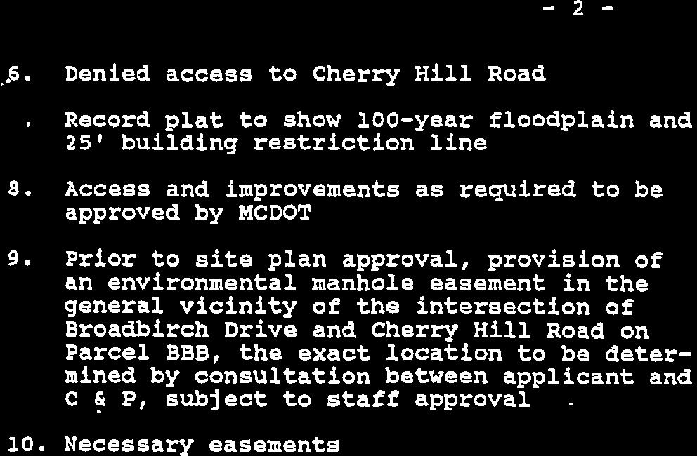
83
84
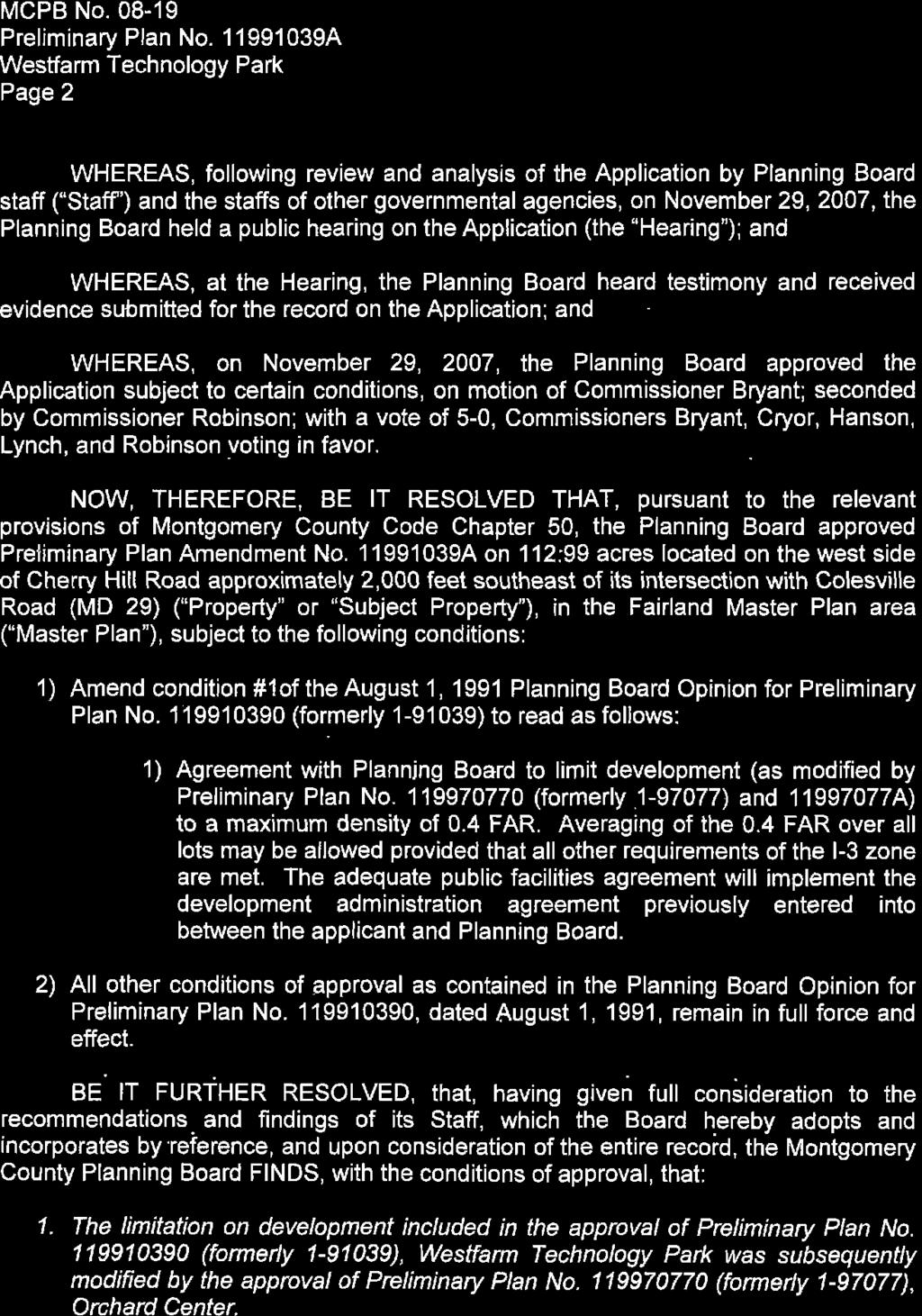
85
86
![Mol+tconrnny Coulrry PreNNruc Boeno THE MARYLAND.NATIONAL CAPITAL PARK AND PLANNING COMMISS]ON ^pfr?4 t&g MCPB No. 08-159 Site Plan No.](/docs-images/85/93053001/images/87-1.jpg "820080210 Project Name: Washington Adventist Hospital Date of Hearing: December 4, 2008 MONTGOMERY COUNTY PLANNING BOARD RESOLUTION WHEREAS, pursuant to Montgomery County Code Division 59-D-3, the")
87 Mol+tconrnny Coulrry PreNNruc Boeno THE MARYLAND.NATIONAL CAPITAL PARK AND PLANNING COMMISS]ON ^pfr?4 t&g MCPB No Site Plan No Project Name: Washington Adventist Hospital Date of Hearing: December 4, 2008 MONTGOMERY COUNTY PLANNING BOARD RESOLUTION WHEREAS, pursuant to Montgomery County Code Division 59-D-3, the Montgomery County Planning Board ("PIanning Board'') is vested with the authority to review site plan applications; and WHEREAS, on March 21, 2008, Adventist Healthcare, lnc. ("Appticant"), filed an application for approval of a site plan for 803, 570 gross square feet of commercial development for a main hospital building, ambulatory care building, faith center, medical office buildings and parking ("Site PIan" or "Plan") on acres of l-l and l-3 -zoned land and within the US 29lCherry Hill Road Employment Area Overlay Zone, located at the southwestern bend of Plum Orchard Drive and consisting of parcels BB, CC, RR, SS and MMM in the Fairland Master Plan area ("Property" or "subject Property"); and WHEREAS, Applicant' s site plan application was designated Site Plan No, , Washington Adventist Hospital (the"application"); and WHEREAS, Planning Board staff ("Staff") issued a memorandum to the planning Board, dated November 24, 2008, setting forth its analysis of, and recommendation for approval of the Application, subjecto certain conditions ("Staff Report"); and WHEREAS, following review and analysis of the Application by Staff and the siaffs of other governmental agencies, on December 4, 2008, the Planning Board held a public hearing on the Application (the"hearing"); and WHEREAS, at the Hearing, the Planning Board heard testimony and received evidence submitted for the record on the Application; and WHEREAS, on December 4, 2008,the Planning Board approved the Application subject to conditions the motion of Commissioner Robinson; seconded bv Ahrlr^\/a.l rc t^ Legal Suff iciency: 10 Chairman's Oflice: 301, Fax: 3O org mcp-chaiman@mncppc.org roo%,eacreddader

88 MCPB No Site Plan No Washington Adventist Hospital Page 2 Commissioner Cryor; with a vote of 5-0, Commissioners Alfandre, Cryor, Hanson Presley and Robinson voting in favor, NOW, THEREFORE, BE lt RESOLVED that, pursuant to the relevant provisions of Montgomery County Code Chapter 59, the Montgomery County Planning Board APPROVESite Plan No, for 802,805 gross square feet of commercial development including a main hospital building, ambulatory care building, faith center, two multi-level parking structures and tvvo medical office buildings, on net acres in the l-1 and l-3 zones and the US 29l Cherry Hill Road Employment Area Overlay Zone, subjecto the following conditions: Conformance with Previous Approvals 1. SoecialExceptionConformance The proposedevelopment must comply with the conditions of approval of Special Exception dated October 27, Any variations in this site plan to the Special Exception will require an amendment to the Special Exception, including any subsequent Site Plan amendments. 2. PreliminaryPlanConformance The propose development must comply with the conditions of approval that are applicable to the Property for preliminary plans.l and.l as listed in the Planning Board Resolution dated February 13, 2008, unless amended. This includes but is not limited to all references to density, rights-ofway, dedications, easements, transportation conditions, DOT conditions, and DPS stormwater conditions. Environment 3. Forest Conservation & Tree Save The propose development must comply with the conditions of the approved final forest conservation plan as described in the Environmental Planning memorandum dated November 3, 2008: a, The Applicant must comply with the conditions of approval for the preliminary/final forest conservation plan. The Applicant shall satisfy all standard conditions prior to recording of plat(s) or Montgomery County Department of Permitting Services ('MCDPS') issuance of sediment and erosion control permit(s), as appropriate. In addition to standard final forest conservation plan requirements, the plan must be revised to include the following items:

89 MCPB No Site Plan No Washington Adventist Hospital Page 3 i. Revise the forest conservation worksheet to show the existing forest area outside the proposed Category easement on parcel BB as "counted as cleared" and identify the area with the corresponding graphic symbol on the plan. Adjusthe worksheet accordingly. ii. Label all existing and proposed easements for each easement,s intended purpose, including the water line in the vicinity of the stormwater management pond. b. A Category conservation easement must be placed over forest retention areas, forest planting areas, and that portion of the environmental buffer that does not include a County stormwater management easement. Show the Category I conservation easement on record plat(s). c. No clearing or grading prior to all necessary inspections as required in Section 110 of the Forest Conservation Regulations. 4. StormwaterManaqement The proposedevelopment is subjecto Stormwater Management Concept approval conditions dated January 28, 2008 unless amended and approved by the Montgomery County Department of Permitting Services. 4 LEED Certification The Applicant must achieve a LEED (Leadership in Energy and Environmental Design) "Certified" Certification, as defined by the U.S. Green Building Council ("USGBC') under the LEED Standard for New Construction & Major Renovation (LEED-NCv2.2), or other equivalent certification based on energy and environmental design standards approved by the Department of permitting Services. Open Space, Recreation, and Amenities 6. Amenities a. A concept of thd special features identified at the main entry and plaza areas of the faith center must be provided on the certified site plan with respecto type of feature, material and finish, height and alternate location. The special features must be presented to the planning Board Staff comprised of at a minimum, representatives of the Site plan Review and Urban Design divisions for their approval. The certified site plan will note that the special features are to be identified on supplemental sheets.

90 MCPB No Site Plan No Washington Adventist Hospital Page 4 The final design of the special features must be provided in document form as a supplemental sheet to the M-NCppC and DpS-Site plan Enforcement, b. The Applicant must provide details of the canopies that include elevations and sections (including information about nominal dimensions, primary structures and materials application) at the time of Certified Site plan.' 7. RecreationandOpenSpace Land Use 8. Uses Site Plan The Applicant is responsible for providing the hard surface path, boardwalk and picnic shelter around the lake as a passive recreational amenitv in accord with the Development Program. The proposedevelopment shall be limited to the following uses: a. 7-story above-grade main hospital building (plus penthouse level) and attached faith center; b. 2-story above-grade ambulatory care building (plus penthouse level;; c. S-story above-grade medical office building (MOB1) (plus penthouse level) and 4-story above-grade medical office building (MOB2)(plus penthouse level): and d. 6-level south parking garage (4 levels above-grade) and 6-level north parking garage (1 level above-grade). Architectural features The buildings must maintain a consistent architectural treatment of a minimum two-story and/or 3OJoot base. 10. Landscapinq a. Provide green-screen material on the landscape plan, consistent with that shown on the architectural elevations.
. 11.")
91 MCPB No Site PIan No Washington Adventist Hospital Page5 b. Provide revised planting plan to lnclude shade trees, ornamental trees and shrubs for the reconfigured layout of the main entry (Emergency Department). 11. LandscapeSuretv The Applicant shall provide a surety (letter of credit, performance bond) in accordance with Section Sg-D-3.S(d) of the Montgomery County Zoning Ordinance with the following provisions: a. The amount of the surety shalr incrude prant materiar, on-site righting, recreational facilities, and site furniture within the relevant phase of development. surety to be posted prior to issuance of first buirding permit within each phase of development and shail be tied to the deverbpmenr program. b. Provide a cost estimate of the materials and facilities, which will establish the initial bond amount. c. Completion of plantings by phase, to be followed by inspection and bond reduction. Inspection approval will start the 1 year maintenance period ano bond release will occur at the expiration of the one year maintenance period. d. Provide a screening/landscape amenities agreementhat outlines the responsibilities of the respective parties and incorporates the cost estimate. Agreement to be executed prior to issuance of the first buildino permit. 12. Liqhtinq a. The lighting distribution and photometric plan with summary report and tabulations must conform to IESNA standards for commercial development. b. All onsite light fixtures must be full cufoff fixtures. c. Deflectorshall be installed on all fixtures causing potential glare or excess illumination, specifically on lhe perimeter fixtures. d. lllumination levels for on-site lighting shall not exceed 0.5 footcandles (fc) at any property line abutting county roads,

92 MCPB No Site Plan No Washington Adventist Hospital Page 6 e. The height of the light poles shall not exceed 1S feet including the mounting base for the on-site upright light fixtures and 1S feet for the light fixtures on the top surface of the parking garage, trl. DevelopmentProqram The Applicant must construct the propose development in accordance with a development program that will be reviewed and approved prior to the approval of the Certified Site Plan. The development program must include the following items in its phasing schedule: a. o. The faith center plaza(s), including landscaping, lighting, seating areas, paving, overhead canopies, and water featureshall be comdleted within 6 months of the issuance of the use and occupancy permit associated with the faith center. On-site street lamps, streetree planting and sidewalks must be installed within six months after street construction is complete.d. The planting area, covered walkway, landscaping and lighting and paving must be completed within 6 months of the use and occupancy permit associated with the ambulatory care building. o. The pathway, including the boardwalk, surrounding the lake and picnic shelter shall be constructed prior to issuance of the last use and occupancy permit for the site. The entry to the main building, including the planting areas, buffers, canopy, bike racks, lighting and seating areas must be completed prior to the issuance of the use and occupancy permit for the main building. The water feature and special feature areas will be occupied bv annual plantings until the applicable features are implemenied; such implementation must occur within two years of the issuance of use and occupancy permits for the main building. T. s. The covered walkway from the northern parking garage to the entry of the Emergency Department and pedestrian link, and landscaping and iighting must be constructed prior to the issuance of the use and occupancv permit for the main building. Clearing and grading must correspond to the construction phasing to minimize soil erosion and must not occur prior to approval of the Final

93 MCPB No Site Plan No Washington Adventist Hospital PageT Forest Conservation Plan, Sediment Control Plan, and M-NCppC inspection and approval of all tree-save areas and protection devices. n. Provid each section ol the development with necessary roads in accordance with the Development Program. The development program must provide stormwater management, sediment and erosion control, reforestation, trip mitigation, and other features. 14. Certified Site Plan Prior to approval of the Certified Site Plan the following revisions must be made and/or information provided subjecto Staff review and approval: a. Include the final forest conservation approval, stormwater management concept approval, development program, including the phasing diagram, inspection schedule, and site plan resolution on the approval or cover sheet. b. c. o. Add a note to ihe site plan stating that "M-NCPPC staff must inspect all tree-save areas and protection devices pnor to clearing and grading." Modify data table to include interior green space requirements in the parking islands and structures and changes to the number of parking spaces as a result of the alternative layout. Provide an alternative parking layout and pedestrian connection at the main entry of the hospital building, Details of the greenscreen on the southern parkin garage. BE lt FURTHE RESOLVED that all site development elements as shown on the washington Adventist Hospital drawingstamped by the M-NCppc on october 14, 2008, shall be required, except as modified by the above conditions of approval; and BE lt FURTHER RESOLVED that, having given tull consideration to the recommendations and findings of its staff, which the planning Board hereby adopts and incorporates by reference, and upon consideration of the entire record, the Montgomery County Planning Board FINDS, with the conditions of approval, that:

94 MCPB No Site Plan No Washington Adventist Hospital Page 8 7 The Site Plan conf orms to all non-illusttativelements of a development plan or diagrammatic plan, and all binding elements of a schematic development plan, ceftified by the Hearing Examiner under Section 59-D-1.64, or is consistent with an approved project plan for the optional method of development if required, unless the Planning Board expressly modi fies any element of the project plan. Neither a development plan, diagrammatic plan, schematic development plan, nor project plan was required tor the subject site 2. The Site Plan meets all of the requirements of the applicable zone. The proposed hospital use and medical office building uses are allowed in the l-l and l-3 Zones and the US 29l Cherry Hill Road Employment Area Overlay Zone as a Special Exception Use. Special Exception was approved by the Board of Appeals on October 27, 2008 and required specific elements on the plan, which have been incorporated into the site plan. As the project data table below indicates, the site plan meets all of the development standards of the respective zone and overlay zone. With respect to building height, setbacks, and density the proposedevelopment meets the standards permitted in the zone. With respecto green space the proposed development provides a significantly greater amount of permeable surface, landscaped open space and environmentally protected areas that will be preserved. RequirementsoftheFlandl-3zones The Staff Report contains a data table showing how the development standards proposed comply with the Zoning Ordinance required development standards and, where applicable, the Hospital Special Exception developments standards. Based on this data table and other uncontested evidence and testimony of record, the Planning Board finds that the Application meets all of the applicable requirements of the l-1 and l-3 Zones and the US 29lCheny Hill Road Employment Area Overlay Zone. The following data table sets forth the development standards approved by the Planning Board and binding on the Applicant. Data Table Development Standard Permitted./ Required Hospital Special Exception Development Standards Approved bv the Board and
 20 ac min. 5 ac min. sf.t Less Previons Dedication I.53 ac (66,614 sf) 48.")
 Tottrl I-3 Zoned Gross 40,05 ac ( 1,741,842 Trttct Area (acres) sf) l-l Zone Gross Tract Area Gross Tract Area (acres) 10.")
= I-3 Zone FAR (based on I-3 Zoned gross 0.5 0.")
95 MCPB No Site Plan No Washington Adventist Hospital Page9 Binding on the Applicant Net Lot Area (AC): Gross Tract ac (2,195,075 Area(acres) 20 ac min. 5 ac min. sf.t Less Previons Dedication I.53 ac (66,614 sf) 48.86oc (2,128,461 tfl Net Lot Areu (acres)= l-3 Zone Gross Tract Area ac (1,618,228 Net Land Area (acres) sl) Previous Dedication 1.53 ac (66,614 sf) Tottrl I-3 Zoned Gross 40,05 ac ( 1,741,842 Trttct Area (acres) sf) l-l Zone Gross Tract Area Gross Tract Area (acres) 10.3,1 ac (450,233 sfl Hospital Gross Floor Area(GFA): Main Building 498,173 sf Faith Center 13,003 sf Ambulatory Care 5R 2q4 <f MOBI 133,335sf MOB2 100,000 sf Total Gross Floor Area ofhospital 802,805 sf FloorAreaRatio (FAR)= I-3 Zone FAR (based on I-3 Zoned gross ' I-3 Zone l-37nne l-3 Zone I-3 Zone l-l Zone Parcel BB Parcel CC Parcel RR Parcel SS Parcel MMM TotalArea sf. (580 ac.) sf.('7.73 ac ) 364,846 si (8.38 ac. ) 723,686 st (16. 6l ac.) 450,233 sf. (10.34 ac. ) 2.128,161 sl ( ac. )
 j: Ma,ximum FAR, provided applicant for developmentobtains approval of a traffic mitigation agreement at the time of site plan review.")
96 MCPB No Site Plan No Washington Adventist Hospital Paoe 10 tract ar ea) j: Ma,ximum FAR, provided applicant for developmentobtains approval of a traffic mitigation agreement at the time of site plan review. that will result in traffic generation equal to or less than a project wirh a FAR of Green Space Requirement (percentageofgross tract area)3: 354/o min AC tc (73Va) Off-street Parking Coverage (percentage of gross tract area) 45c/c max AC. 2.78ac(5.5a/o) Nlaximum Building Heieht(FT): 100'(N/A) 145' 145' (max.) MinimumBuilding Setbacks (FT): From an abuing lot classified in the I-3 or R&D zones: 20' (N/A) 50' 50' minimum From abutting commercial or industrial zoning other than the I-3 or R&D ZONES: 25' (N/A) 50' 50' minimum From Plum Orchard Road (an industrial road that separates the 25', (N/A) 50' 50'minimum r The Floor Area Ratio (FAR.) was computetl dividing the Gross Floor Area of rhe Hospital (8o2.805 sf.) by the Gross Traot Area of the I-3 Zoned Parcels BB, CC, RR, SS (,711,842 sf.). I In unusual circumstances, may be waived b). the Planning Boald at the time of site plan approval, upon finding that a more compatible arrangernent of uses would result.

97 MCPB No Site Plan No Washington Adventist Hospital Page 11 "Current plans show 2,162 spaces, but this number will be reduced by a total of 26 spaces from among one or boti parking structures at cenified site plan in order to meet minimum LEED requirementszone frorn a conlmercial or industrial zone): From another building on the same lot: 30' 30' minimum Minimum Parking, Loading, and Maneuvering Area Setbacks (FT): From abutting commercial or industrial zoning other than the I-3 or R&D ZONES: 25' 25'minimum From an abutting lot classified in the I-3 or R&D zones: 20' 20' minimum From Plum Orchard Road (an arterial road that separates the zone from a commercial or industrialzone): 35' 35'minimum Street Frontage and access (FT): Amount of frontage each lot must have on a public or private slre9t: 150' (N/A) 200' r'704.66'. ParkingSpaccs Standard Spaces (including surface spaces, accessible and van accessible spaces) Motorcycle Spaces 40 Bicycle Parking 108


98 MCPB No Site Plan No Washington Adventist Hospital Page The locations of the buildings and structures, the open spaces, landscaping, recreation facilities, and pedestrian and vehicular circulation systems are adequate, saf e, and ef ficient. The primary buildings and structures, specifically the hospital and ambulatory care facility, one medical office building, and the southern parking garage are located on the southwestern bend of plum Orchard Drive. The campus setting is organized in a well-thought-out and efficient manner to promote continuity between buildings and space. Additional buildings, MOB2 and the northern parking structure, are located further north of the main campus and directly fronting the west side of plum orchard Drive. The locations provide easy access to the building from adjoining sidewalks and parking. The builorngs and structures are safe and efficient and adequately supporthe other uses on the site in a functional manner. The open space provided is in excess of the required amount and incorporates many of the environmentally sensitive areas and the landscapeo amenity areas that surround the buildings. Amenity landscaping is provided throughout the hospital site including foundation planting around the buildings, accent and ornamental planting within the amenity areas, and screening to buffer the parking garages and surface parking areas from the street. The healino gardens are located on the south side of the main building and include a mii ot plant and paver materials to offer a relaxing environment for patients. The southern parking structure is adequately landscaped at the base of the structure with trees and shrubs, as well as a green-screen on the parking structure fagaoe. Interior lighting wirr create enough visibility to provide safety and security without causing glare on the adjacent roads or properties. Lighting on the rooitop of the garages has been kept to a minimum heighto promote illumination while still providing for pedestrian safety. There are no recreation facilities required for this site plan, since this is not a residential development; however, the application is providing walking paths, benches, bicycle facilities and a healin garden as part of the passive activity areas for the hospital program. The lake, a maior environmental feature of the site, is surrounded by a walking path and landscaping. The open spaces, landscaping, and site details adequately and efficiently address the needs of the proposed use, while providing an ad-equare, safe and comfortablenvironment. Pedestrian access from adjacent sidewalks adequately and efficiently integrates this site into the surrounding area. safety is enhanced by several improvements such as the covered walkways leading from the structured parking garages and medical office buildings to the main building and a separate vehicular emergency access from Plum orchard Drive. The vehicular circulation

99 MCPB No Site Plan No Washington Adventist Hospital Page 13 design efficiently directs traffic into and through the site with minimal impacts io pedestrian circulation. Additional improvements are required in accordance with the special exception recommendations that include specific intersection ano road improvements, an employee shuttle service and implementation of the transportation management plan and bicycle facilities. As designed, the paved area for both pedestrians and vehicles reduces current imperviousness on site and promotes an efficient and adequate means to provide a safe atmosphere for pedestrians, cyclists, and vehicles, The additional improvements and requirements of the special exception provide for a more efficient transportation program and circulation system. 4. Each structure and use is compatible with other uses and other site plans and with existing and proposed adjacent development. The proposed buildings, including the main hospital and supporting ambulatory care, medical office buildings and parking structures, are compatible with the surrounding uses and adjacent site plans, with respecto variation In height, building organization and massing and relationship to other buildings. The structures are in scale with the nearby buildings and is located such that they will not adversely lmpact existing or proposed adjacent uses. 5. The site Plan meets all applicable requirements of chapter 22A regarding forest conservation, Chapter 19 regarding water resource protection, and any other applicable law. The proposedevelopment is not subjecto water resources protection but is subjecto the forest conservation law. The site consists ot acres of existing forest, including high priority forest, with 33large trees and one specimen tree. A total of 12 significant trees will be retained post development. Six significant trees are within a foresto De saved on the west side of the stormwater management pond, while the remaining six trees are located at the north portion of the site. The site also contains a stream, wetlands, a portion of which are forested 1O0-year floodplain, steep slopes associated with highly erodible soils, severe slopes and associated environmental buffers on-site. All of the environmental buffers in this forest stand and most of the forest will be placed in a Category Conservation Easement for permanent protection. The stormwater management concept consists of on-site channel protection measures via the existing Westfarm Regional pond; on-site water quality controlor non-rooftop areas via installation of proprietary filtration

100 MCPB No Site Plan No Washington Adventist Hospital Page '14 cartridges. onsite recharge is not require due to the proximity of the site to the existing retention pond. BE lr FURTHER RESOLVED, that this resolution incorporates by reference all evidence of record, including maps, drawings, memoranda, correspondence, and other information; and BE lt FURTHER RESOLVED, that this Site plan shail remain valid as provided in Montgomery County Code g 59-D-3, 8; and BE lt FURTHER RESOLVED, that the date of this resotution is Ft 4 m (which is the date that this resolution is mailed to all parties of record); and BE lt FURTHER RESOLVED, that any party authorized by law to tare an administrative appeal must initiate such an appeal within thirty days of the date of this Resolution, consistent with the procedural rules for the judicial review of administrative agency decisions in Circuit Court (Rule 7-203, Maryland Rules). CERTIFICATION This is to certifu that the foregoing is a true and correct copy of a resolution adopted by The Montgomery county Planning Board of rhe Maryland-National capital park and Planning commission on motion of commissioner presley, seconded by commissroner Robinson, with Commissioners Hanson, Robinson, Cryor, and presley present and voting in favor of the motion, and commissioner Alfandre necessarily absent at its regular meeting held on Thursday, March 26, 2009, in Silver Spring, Maryland., Chairman County Planning Board
101 FER MONTGOMERY COUNTY PLANNING BOARD THE MARYLAND-NATIONAL CAPITAL PARK AND PLANNING COMMISSION MCPB No Site Plan No A Project Name: Washington Adventist Hospital Hearing Date: January 7, 2010 MONTGOMERY COUNTY PLANNING BOARD RESOLUTION WHEREAS, by Planning Board Resolution dated April 24, 2009, the Montgomery County Planning Board ("Planning Board") approved the site plan application submitted by Adventist HealthCare Inc. ("Applicant"), designated , for the approval of 802,805 gross square feet of commercial development for a main hospital building, ambulatory care building, faith center, two medical office buildings and parking facilities on acres of 1-1 and 1-3zoned land; and WHEREAS, pursuant to Montgomery County Code Division , the Planning Board is required to review amendments to approved site plans; and WHEREAS, on August 24, 2009, Applicant, filed a site plan limited amendment application designated A, Washington Adventist Hospital (the "Amendment") for approval of the following modifications to the approved site plan: 1. Modify the loading dock area of the Medical Office.Building 2 (MOB2); 2. Modify the entrance of the second level within the North Garage; 3. Modify the oxygen farm and add a generator farm within the Service Areas; 4. Modify the building footprint for the Main Building; 5. Remove a story from the Main Building; 6. Remove enclosed penthouse from the Main Building; 7. Remove the porte-cochere of the Main Building; 8. Modify the Building footprint of Building A (formerly the Ambulatory Care Building); 9. Add building stories to Building A; 10. Modify the building footprint of the South Garage; 11. Modify the building footprint of the MOB1; 12. Change the building entrance location of the MOB1; 13. Relocate the loading dock access point of the MOB1; 14. Modify the campus canopy system; 15. Modify the Hardscape Plan; 16. Increase connectivity between the Main Building and Building A; Approved as to Legal Sufficiency: 100% recycled paper

102 MCPB No Site Plan No A Washington Adventist Hospital Page 2 17.Modify the lake trail system; 18. Modify the building design and aesthetics; 19. Modify the Landscape and Forest Conservation Plans; and 20. Modify site details and amenities. WHEREAS, following review and analysis of the Amendment by Planning Board staff ("Staff") and the staffs of other applicable governmental agencies, Staff issued a memorandum to the Planning Board dated December 28, 2009, setting forth its analysis and recommendation for approval of the Amendment ("Staff Report"); WHEREAS, on January 7, 2010, Staff presented the Amendment to the Planning Board at a public hearing on the Amendment (the "Hearing") where the Planning Board heard testimony and received evidence submitted for the record on the Amendment; and WHEREAS, on January 7, 2010, the Planning Board approved the Amendment subject to the conditions in the Staff Report as revised at the Hearing on the motion of Commissioner Presley, seconded by Commissioner Wells-Harley, with a vote of 4-0, Commissioners Alfandre, Hanson, Presley and Wells-Harley voting in favor, with one Planning Board seat being vacant. NOW, THEREFORE, BE IT RESOLVED THAT, pursuant to the relevant provisions of Montgomery County Code Chapter 59, the Planning Board hereby adopts the Staff's recommendation and analysis set forth in the Staff Report and hereby APPROVES the Limited Site Plan Amendment No A, subject to the following conditions: Conformance with Previous Approvals 1. Special Exception Conformance The proposed development must comply with the conditions of approval of Special Exception S-2721 dated October 27,2007. Any variations in this Site Plan ( and variations through any subsequent Site Plan amendments) will require an amendment to the Special Exception. 2. Preliminary Plan Conformance The proposed development must comply with the conditions of approval for preliminary plans A and as listed in the Planning Board Resolution dated February 13, 2008 unless amended. This includes but is not limited to all references to density, rights-of-way, dedications, easements, transportation conditions, DOT conditions, and DPS stormwater conditions. 01/07/10

103 MCPB No Site Plan No A Washington Adventist Hospital Page 3 3. Site Plan Conformance The proposed development must comply with the conditions of approval for site plan as listed in the Planning Board Resolution dated April 24,2009, except as amended by this Resolution. Environment 4. Forest Conservation & Tree Save The proposed development must comply with the conditions of the amended and approved final forest conservation plan as described in the Environmental Planning memorandum dated December 10, 2009: a. The Applicant must comply with the conditions of the approval for the final forest conservation plan as amended herein. The Applicant shall satisfy all standard conditions prior to recording of plat(s), or Montgomery County Department of Permitting Services ("MCDPS") issuance of sediment and erosion control permit(s), as appropriate. In addition to standard final forest conservation requirements, the plan must be revised to include the following items: I. Revise the forest conservation plan and worksheet to show additional forest removal associated with the preferred alignment and/or design of the stormwater management outfall at the northern-most corner of the proposed North Parking Garage II. Show and label on the plan the adjusted water line in the vicinity of the regional stormwater management pond, and the preferred alignment and/or design for the 36-inch stormwater outfall located north of the North Parking Garage. III. Revise the Category I conservation easement north of the North Parking Garage on the record plat to exclude the 30-foot wide easement for the preferred alignment and/or design of the 36-inch stormwater management outfall. b. Prior to signature approval of the certified forest conservation plan, the location and limit of disturbance (LOD) associated with the preferred stormwater management outfall alignment in the vicinity of the North Parking Garage shall be adjusted to minimize impacts to significant and specimen trees along its alignment to the extent feasible. The preferred alignment shall be flagged for review by the M-NCPPC forest conservation inspector; DPS plan reviewer and the applicant's Maryland tree expert. Any adjustments to the LOD shall be reflected on the project's FFCP, Sediment and Erosion Control and Final Engineering plans. c. The Arborist's Report shall be revised to include tree protection measures and recommended treatments to minimize tree damage along the selected outfall 01/07/10
104 MCPB NO Site Plan No A Washington Adventist Hospital Page 4 alignment. The Report shall address significant and specimen trees within 50 feet on either side of the proposed LOD so that the low end of individual tree's DBH can be determined after the alignment has been flagged in the field and checked by Environmental Planning staff. Open Space, Recreation & Amenities 5. Amenities & Recreation Facilities The Applicant is responsible for maintaining amenities including, but not limited to, all play equipment, special and water features. a. A concept of the special features identified at the main entry and plaza areas of the faith center must be provided on the certified site plan with respect to type of feature, material and finish, height and alternate location. The special features must be presented to the Planning Board Staff comprised of at a minimum, representatives of the Site Plan Review and Urban Design divisions for their approval. The certified site plan will note that the special features are to be identified on supplemental sheets. The final design of the special features must be provided in document form as a supplemental sheet to the M-NCPPC and DPS-Site Plan Enforcement. b. The Applicant shall provide a playground layout for the tot lot; specifically labeling the surrounding radii and its proximity to each piece of equipment and/or seating areas. Transportation & Circulation 6. Transportation & Pedestrian Circulation The on-site traffic signage will be coordinated by the project's traffic engineer with the Montgomery County Park and Planning Staff prior to the Certified Site Plan set. Site Plan The Stormwater Management, LEED Certification, Architectural Features, Landscaping, Landscape Surety, Lighting, Development Program, and the Certified Site Plan sections should be consistent with the previously approved resolution dated April 24, BE IT FURTHER RESOLVED, that the Planning Board FINDS that the Amendment is consistent with the provisions of of the Zoning Ordinance and that the Amendment does not alter the intent, objectives, or requirements expressed or imposed by the Planning Board in connection with the originally approved site plan; and 01/07/10
105 MCPB No Site Plan No A Washington Adventist Hospital Page 5 BE IT FURTHER RESOLVED that all site development elements as shown on the Washington Adventist Hospital drawings stamped by the M-NCPPC on December 11, 2009 (Landscape and Lighting Plans), and December 30, 2009 (Site Plan), shall be required, except as modified by the above conditions of approval; and BE IT FURTHER RESOLVED, that this Resolution constitutes the written opinion of the Board and incorporates by reference all evidence of record, including maps, drawings, memoranda, correspondence, and other information; and BE IT FURTHER RESOLVED, that this Amendment shall remain valid as provided in Montgomery County Code ; and BE IT FURTHER RESOLVED, that the date of this written resolution is FEB (which is the date that this resolution is mailed to all parties of record); and BE IT FURTHER RESOLVED, that any party authorized by law to take an administrative appeal must initiate such an appeal within thirty days of the date of this written opinion, consistent with the procedural rules for the judicial review of administrative agency decisions in Circuit Court (Rule 7-203, Maryland Rules). * * * * * * * * * * * * * CERTIFICATION This is to certify that the foregoing is a true and correct copy of a resolution adopted by The Montgomery County Planning Board of The Maryland-National Capital Park and Planning Commission on motion of Vice Chair Wells-Harley, seconded by Commissioner Presley, with Chairman Hanson, Vice Chair Wells-Harley, and Commissioners Alfandre and Presley present and voting in favor of the motion at its regular meeting held on Thursday, January 28, 2010 in Silver Spring, Maryland. Royce Han$on, Chairman Montgomery County Planning Board 01107/1 0
106 AUG, 0 2O'O~ MONTGOMERY COUNTY PLANNING BOARD THE MARYLAND-NATIONAL CAPITAL PARK AND PLANNING COMMISSION MCPB No Site Plan No B Project Name: Washington Adventist Hospital Hearing Date: June 24, 2010 MONTGOMERY COUNTY PLANNING BOARD RESOLUTION WHEREAS, pursuant to Montgomery County Code Division , the Montgomery County Planning Board ("Planning Board") is required to review amendments to approved site plans; and WHEREAS, on May 17, 2010, Adventist HealthCare, Inc. ("Applicant"), filed a site plan amendment application designated B, Washington Adventist Hospital (the "Amendment") for approval of the following modification to Condition No.1 of the previously approved Site Plan in order to ensure compliance with the Board of Appeals ultimate determination regarding transportation improvements associated with the approved Special Exception No. S-2721; and WHEREAS, following review and analysis of the Amendment by Planning Board staff ("Staff") and the staff of other applicable governmental agencies, Staff issued a memorandum to the Planning Board dated June 11, 2010, setting forth its analysis and recommendation for approval of the Amendment ("Staff Report"); and WHEREAS, on June 24, 2010, Staff presented the Amendment to the Planning Board at a public hearing on the Amendment (the "Hearing") where the Planning Board heard testimony and received evidence submitted for the record on the Amendment; and WHEREAS, on June 24, 2010, the Planning Board approved the Amendment subject to conditions as revised at the Hearing on the motion of Commissioner Presley, seconded by Commissioner Dreyfuss, with a vote of 4-0, Commissioners Alfandre, Dreyfuss, Presley and Wells-Harley voting in favor, one seat being vacant. NOW, THEREFORE, BE IT RESOLVED THAT, pursuant to the relevant provisions of Montgomery County Code Chapter 59, the Planning Board hereby adopts the Staff's recommendation and analysis set forth in the Staff Report and hereby approves the Site Plan Amendment No B; and i Legal Sufficiency: I Approved 8787 Georgia as to AvMJ.N{$j~~~1 (AM- ~. ~lifm8m91 0 ChaiLma s Office: Fax: 30] mcp-chairman@mncppc.org 100% recycled paper

107 MCPB No Site Plan No B Washington Adventist Hospital Page 2 NOW, THEREFORE, BE IT RESOLVED that, pursuant to the relevant provisions of Montgomery County Code Chapter 59, the Montgomery County Planning Board hereby APPROVES the Amendment, subject to the following condition, which replaces Condition No.1 of the previously approved Site Plan: Special Exception Conformance. The proposed development must comply with the conditions of approval of Special Exception S-2721 dated October 27, 2008, including any amendments. Any variations in this Site Plan from the Special Exception Plan approved by the Board of Appeals (and variations through any subsequent site plan amendments) will require an amendment to the Special Exception; BE IT FURTHER RESOLVED, that the Planning Board adopts the Staff's recommendation and analysis set forth in the Staff Report as revised at the Hearing and FINDS that the Amendment is consistent with the provisions of of the Zoning Ordinance and that the Amendment does not alter the intent, objectives, or requirements expressed or imposed by the Planning Board in connection with the originally approved site plan; and BE IT FURTHER RESOLVED that all site development elements as shown on Washington Adventist Hospital drawings stamped by the M-NCPPC on May 17, 2010, shall be required, except as modified by the above conditions of approval; and BE IT FURTHER RESOLVED, that this Resolution constitutes the written opinion of the Board and incorporates by reference all evidence of record, including maps, drawings, memoranda, correspondence, and other information; and BE IT FURTHER RESOLVED, that this Amendment shall remain valid as provided in Montgomery County Code ; and BE 120 fiurther RESOLVED, that the date of this written resolution is -AUG '0 \ (which is the date that this resolution is mailed to all parties of record); and BE IT FURTHER RESOLVED, that any party authorized by law to take an administrative appeal must initiate such an appeal within thirty days of the date of this written opinion, consistent with the procedural rules for the judicial review of administrative agency decisions in Circuit Court (Rule 7-203, Maryland Rules). * * * * * * * * * * * CERTIFICATION This is to certify that the foregoing is a true and correct copy of a resolution adopted by the Montgomery County Planning Board of The Maryland-National Capital Park and Planning Commission on motion of Commissioner Wells-Harley, seconded by
108 MCPB No Site Plan No B Washington Adventist Hospital Page 3 Commissioner Alfandre, with Commissioners Wells-Harley, Alfandre, Dreyfuss, and Presley voting in favor of the motion, and with Chair Carrier abstaining, at its regular meeting held on Thursday, July 29, 2010, in &ilver Spring, Maryland.
109

110
MONTGOMERY COUNTY PLANNING DEPARTMENT THE MARYLAND-NATIONAL CAPITAL PARK AND PLANNING COMMISSION
 MONTGOMERY COUNTY PLANNING DEPARTMENT THE MARYLAND-NATIONAL CAPITAL PARK AND PLANNING COMMISSION MCPB Item No. Date: 12-10-15 Leisure World Clubhouse II Addition Fitness Center, Limited Site Plan Amendment
MONTGOMERY COUNTY PLANNING DEPARTMENT THE MARYLAND-NATIONAL CAPITAL PARK AND PLANNING COMMISSION
 MONTGOMERY COUNTY PLANNING DEPARTMENT THE MARYLAND-NATIONAL CAPITAL PARK AND PLANNING COMMISSION The Goddard School in North Bethesda Preliminary Plan Amendment 11996015B and Site Plan Amendment 82006005A
MONTGOMERY COUNTY PLANNING DEPARTMENT THE MARYLAND-NATIONAL CAPITAL PARK AND PLANNING COMMISSION
 MONTGOMERY COUNTY PLANNING DEPARTMENT THE MARYLAND-NATIONAL CAPITAL PARK AND PLANNING COMMISSION MCPB Item No. Date: 3.10.2016 Site Plan 820160040 Nora School Parker Smith, Planning Technician, Area 1,
MONTGOMERY COUNTY PLANNING DEPARTMENT THE MARYLAND-NATIONAL CAPITAL PARK AND PLANNING COMMISSION
 MONTGOMERY COUNTY PLANNING DEPARTMENT THE MARYLAND-NATIONAL CAPITAL PARK AND PLANNING COMMISSION MCPB Item No. Date: 9-4-13 Limited Site Plan Amendment No. 81994026B, Darcars at Montgomery Industrial Park,
MONTGOMERY COUNTY PLANNING DEPARTMENT THE MARYLAND-NATIONAL CAPITAL PARK AND PLANNING COMMISSION
 MONTGOMERY COUNTY PLANNING DEPARTMENT THE MARYLAND-NATIONAL CAPITAL PARK AND PLANNING COMMISSION Montgomery Auto Sales Park: Preliminary Plan No. 11985027A, Site Plan No. 820140130 and Site Plan No. 820140140
MONTGOMERY COUNTY PLANNING DEPARTMENT THE MARYLAND-NATIONAL CAPITAL PARK AND PLANNING COMMISSION
 MONTGOMERY COUNTY PLANNING DEPARTMENT THE MARYLAND-NATIONAL CAPITAL PARK AND PLANNING COMMISSION MCPB Item No. Date: 06-12-14 King of the Nations Christian Fellowship Church: Limited Site Plan Amendment
MONTGOMERY COUNTY PLANNING DEPARTMENT THE MARYLAND-NATIONAL CAPITAL PARK AND PLANNING COMMISSION MCPB Item No.: 13 Date: 07/19/18
 MONTGOMERY COUNTY PLANNING DEPARTMENT THE MARYLAND-NATIONAL CAPITAL PARK AND PLANNING COMMISSION MCPB Item No.: 13 Date: 07/19/18 Black Hill / ViaSat: Project Plan No. 92012004B, Preliminary Plan No. 12012021B,
MONTGOMERY COUNTY PLANNING DEPARTMENT Newell Street. Site Plan Item #2. Maryland-National Capital Park and Planning Commission
 8001 Newell Street Site Plan 820140020 Item #2 December 19, 2013 Redlined Conditions 1. The Applicant must comply with the conditions of approval for Project Plan 920130020 in MCPB Resolution No. 13-74.
MONTGOMERY COUNTY PLANNING DEPARTMENT THE MARYLAND-NATIONAL CAPITAL PARK AND PLANNING COMMISSION
 MONTGOMERY COUNTY PLANNING DEPARTMENT THE MARYLAND-NATIONAL CAPITAL PARK AND PLANNING COMMISSION MCPB Item No. Date: 1/15/2015 Bethesda North Marriott Hotel and Conference Center: Limited Site Plan Amendment
MONTGOMERY COUNTY PLANNING DEPARTMENT THE MARYLAND-NATIONAL CAPITAL PARK AND PLANNING COMMISSION
 MONTGOMERY COUNTY PLANNING DEPARTMENT THE MARYLAND-NATIONAL CAPITAL PARK AND PLANNING COMMISSION MCPB Item No.: 2 Date: 12-19-13 Site Plan 820140020, 8001 Newell Street Neil Braunstein, AICP, Area 1, neil.braunstein@montgomeryplanning.org,
MONTGOMERY COUNTY PLANNING DEPARTMENT THE MARYLAND-NATIONAL CAPITAL PARK AND PLANNING COMMISSION
 MONTGOMERY COUNTY PLANNING DEPARTMENT THE MARYLAND-NATIONAL CAPITAL PARK AND PLANNING COMMISSION MCPB Item No. Date: 07-17-2014 Rock Spring Park, Preliminary Plan Amendment 11998093B and Site Plan Amendment,
MONTGOMERY COUNTY PLANNING DEPARTMENT THE MARYLAND-NATIONAL CAPITAL PARK AND PLANNING COMMISSION
 MONTGOMERY COUNTY PLANNING DEPARTMENT THE MARYLAND-NATIONAL CAPITAL PARK AND PLANNING COMMISSION MCPB Item No. Date: 05-22-14 Consent Item - Park Potomac: Site Plan Amendment No. 82004015K MCS. Molline
MONTGOMERY COUNTY PLANNING DEPARTMENT THE MARYLAND-NATIONAL CAPITAL PARK AND PLANNING COMMISSION
 MONTGOMERY COUNTY PLANNING DEPARTMENT THE MARYLAND-NATIONAL CAPITAL PARK AND PLANNING COMMISSION Gables White Flint, Preliminary Plan No. 120150010 and Site Plan No. 820150010 MCPB Item No. Date: 4/30/2015
Clarksburg Square Road Extension
 Clarksburg Square Road Extension Preliminary Plan No. 120140060 Site Plan No. 820140050 Site Plan Amendment No. 82007022C (Clarksburg Town Center) Clarksburg SPA Water Quality Plan Mandatory Referral MR2015008
MONTGOMERY COUNTY PLANNING DEPARTMENT THE MARYLAND-NATIONAL CAPITAL PARK AND PLANNING COMMISSION
 MONTGOMERY COUNTY PLANNING DEPARTMENT THE MARYLAND-NATIONAL CAPITAL PARK AND PLANNING COMMISSION MCPB Item No. Date: 1/26/12 Hanover Shady Grove, Sketch Plan 320120020 Joshua Sloan, Coordinator, Joshua.Sloan@MontgomeryPlanning.org,
MONTGOMERY COUNTY PLANNING DEPARTMENT
 MONTGOMERY COUNTY PLANNING DEPARTMENT THE MARYLAND-NATIONAL CAPITAL PARK AND PLANNING COMMISSION MCPB Item No.: Date: 5-03-18 Pike and Rose, Phase I: Site Plan Amendment No. 82012002D Rhoda Hersson-Ringskog,
MONTGOMERY COUNTY PLANNING DEPARTMENT THE MARYLAND-NATIONAL CAPITAL PARK AND PLANNING COMMISSION
 MONTGOMERY COUNTY PLANNING DEPARTMENT THE MARYLAND-NATIONAL CAPITAL PARK AND PLANNING COMMISSION MCPB Item No. Date: 05/12/2016 North Bethesda Conference Center Parking Structure, Mandatory Referral No.
MONTGOMERY COUNTY PLANNING DEPARTMENT
 MONTGOMERY COUNTY PLANNING DEPARTMENT THE MARYLAND-NATIONAL CAPITAL PARK AND PLANNING COMMISSION MCPB Item No.: 11 Date: 7-20-17 Burtonsville McDonalds: Site Plan No. 820150020 Jonathan Casey, Senior Planner,
MONTGOMERY COUNTY PLANNING DEPARTMENT THE MARYLAND-NATIONAL CAPITAL PARK AND PLANNING COMMISSION
 MONTGOMERY COUNTY PLANNING DEPARTMENT THE MARYLAND-NATIONAL CAPITAL PARK AND PLANNING COMMISSION MCPB Item No.: 9 Date: 07-20-17 Topgolf - Germantown: Preliminary Plan Amendment No. 12007065B and Site
MONTGOMERY COUNTY PLANNING DEPARTMENT THE MARYLAND-NATIONAL CAPITAL PARK AND PLANNING COMMISSION
 MONTGOMERY COUNTY PLANNING DEPARTMENT THE MARYLAND-NATIONAL CAPITAL PARK AND PLANNING COMMISSION MCPB Item No.: Date: 9-24-15 Plaza Del Mercado Limited Site Plan Amendment 82006004A Crystal Myers, Senior
MONTGOMERY COUNTY PLANNING DEPARTMENT
 MONTGOMERY COUNTY PLANNING DEPARTMENT THE MARYLAND-NATIONAL CAPITAL PARK AND PLANNING COMMISSION MCPB Item No. 4 Date: 12-15-16 CVS Derwood: Site Plan No. 820160150 Calvin Nelson, Jr., Planner Coordinator,
12 January 12, 2011 Public Hearing APPLICANT: TAILWIND DEVELOPMENT GROUP,LLC PROPERTY OWNER: CITY OF VIRGINIA BEACH
 12 January 12, 2011 Public Hearing APPLICANT: TAILWIND DEVELOPMENT GROUP,LLC PROPERTY OWNER: CITY OF VIRGINIA BEACH STAFF PLANNER: Faith Christie REQUEST: Conditional Change of Zoning (from PD-H1 Planned
MONTGOMERY COUNTY PLANNING DEPARTMENT THE MARYLAND-NATIONAL CAPITAL PARK AND PLANNING COMMISSION
 MONTGOMERY COUNTY PLANNING DEPARTMENT THE MARYLAND-NATIONAL CAPITAL PARK AND PLANNING COMMISSION MCPB Item No. Date: 10.25.18 Artery Plaza: Site Plan Amendment 81984002E SD Stephanie Dickel, Planner Coordinator,
MONTGOMERY COUNTY PLANNING DEPARTMENT THE MARYLAND NATIONAL CAPITAL PARK AND PLANNING COMMISSION
 MONTGOMERY COUNTY PLANNING DEPARTMENT THE MARYLAND NATIONAL CAPITAL PARK AND PLANNING COMMISSION MCPB Item No. 3 Date: 1.5.17 7272 Wisconsin Avenue: Sketch Plan Amendment No. 32016004A, Preliminary Plan
MONTGOMERY COUNTY PLANNING DEPARTMENT THE MARYLAND-NATIONAL CAPITAL PARK AND PLANNING COMMISSION
 MONTGOMERY COUNTY PLANNING DEPARTMENT THE MARYLAND-NATIONAL CAPITAL PARK AND PLANNING COMMISSION MCPB Item No. 6 Date: 5-9-13 Site Plan No. 820130090, West Chevy Chase Heights Erin Grayson, Senior Planner,
MONTGOMERY COUNTY PLANNING DEPARTMENT THE MARYLAND-NATIONAL CAPITAL PARK AND PLANNING COMMISSION
 MONTGOMERY COUNTY PLANNING DEPARTMENT THE MARYLAND-NATIONAL CAPITAL PARK AND PLANNING COMMISSION 8015 Old Georgetown Road, Preliminary Plan 120160220, Site Plan 820160090 MCPB Item No.: 8 Date: 11-03-16
Prepared by: Casey Kempenaar, Senior Planner
 CITY OF CITRUS HEIGHTS PLANNING DIVISION STAFF REPORT PLANNING COMMISSION MEETING September 13, 2017 Prepared by: Casey Kempenaar, Senior Planner REQUEST The applicant requests a Design Review Permit Modification
MONTGOMERY COUNTY PLANNING DEPARTMENT THE MARYLAND NATIONAL CAPITAL PARK AND PLANNING COMMISSION
 MONTGOMERY COUNTY PLANNING DEPARTMENT THE MARYLAND NATIONAL CAPITAL PARK AND PLANNING COMMISSION MCPB Item No. 8 Date: 3.30.2017 Project Name: Lot 31/31A Bethesda, Site Plan Amendment, No. 82007018C Elza
MONTGOMERY COUNTY PLANNING DEPARTMENT THE MARYLAND-NATIONAL CAPITAL PARK AND PLANNING COMMISSION
 MONTGOMERY COUNTY PLANNING DEPARTMENT THE MARYLAND-NATIONAL CAPITAL PARK AND PLANNING COMMISSION MCPB Item Date: 09/08/16 The Collection (Formerly Chevy Chase Center): Site Plan Amendment No. 82001013C,
The subject site plan amendment proposes the following revisions to the approved site plan:
 PROPOSED AMENDMENT The subject site plan amendment proposes the following revisions to the approved site plan: 1. The building footprint was modified to accommodate the revised architectural design. 2.
MONTGOMERY COUNTY PLANNING DEPARTMENT
 MONTGOMERY COUNTY PLANNING DEPARTMENT THE MARYLAND-NATIONAL CAPITAL PARK AND PLANNING COMMISSION MCPB Consent Date: 4-26-18 Cabin John Auto Park (N. Bethesda Home Depot), Site Plan Amendment No. 81980017A
Project Name: MELWOOD HOTEL. Date Accepted: 1/12/04. Waived. Planning Board Action Limit: Plan Acreage: 1.7 Zone: Dwelling Units:
 The Maryland-National Capital Park and Planning Commission Prince George's County Planning Department Development Review Division 301-952-3530 Note: Staff reports can be accessed at www.mncppc.org/pgco/planning/plan.htm.
MONTGOMERY COUNTY PLANNING DEPARTMENT THE MARYLAND-NATIONAL CAPITAL PARK AND PLANNING COMMISSION
 MONTGOMERY COUNTY PLANNING DEPARTMENT THE MARYLAND-NATIONAL CAPITAL PARK AND PLANNING COMMISSION Clarksburg Square Road Extension: Preliminary Plan No. 120140060, Preliminary/Final Water Quality Plan,
MONTGOMERY COUNTY PLANNING DEPARTMENT
 MONTGOMERY COUNTY PLANNING DEPARTMENT THE MARYLAND-NATIONAL CAPITAL PARK AND PLANNING COMMISSION North Bethesda Town Center Parcel G Site Plan No. 820180010 MCPB Item No.: Date: 01-25-18 Atul Sharma, Planner
MONTGOMERY COUNTY PLANNING DEPARTMENT THE MARYLAND-NATIONAL CAPITAL PARK AND PLANNING COMMISSION
 MONTGOMERY COUNTY PLANNING DEPARTMENT THE MARYLAND-NATIONAL CAPITAL PARK AND PLANNING COMMISSION MCPB Item No. Date: 7/26/12 Camden Shady Grove (Danac Stiles), Sketch Plan 320120050 Joshua Sloan, Planner
MONTGOMERY COUNTY PLANNING DEPARTMENT
 MONTGOMERY COUNTY PLANNING DEPARTMENT THE MARYLAND-NATIONAL CAPITAL PARK AND PLANNING COMMISSION MCPB Item # Date: 9-6-18 Ourisman Ford at Montgomery Mall, Site Plan No. 82009014B Emily Tettelbaum, Planner
Michael Brown, Senior Planner, Area 2 Planning Division,
 THE MARYLAND-NATIONAL CAPITAL PARK AND PLANNING COMMISSION MCPB Item No. Date: 12-15-11 Glenmont Fire Station, Mandatory Referral, MR 2012007 Michael Brown, Senior Planner, Area 2 Planning Division, michael.brown@montgomeryplanning.org,
MONTGOMERY COUNTY PLANNING DEPARTMENT THE MARYLAND-NATIONAL CAPITAL PARK AND PLANNING COMMISSION
 MONTGOMERY COUNTY PLANNING DEPARTMENT THE MARYLAND-NATIONAL CAPITAL PARK AND PLANNING COMMISSION MCPB Item No. Date10/25/12 Sketch Plan No. 32012004, White Flint Mall Redevelopment Nkosi Yearwood, Senior
COUNTY COUNCIL OF PRINCE GEORGE'S COUNTY, MARYLAND, SITTING AS THE DISTRICT COUNCIL ORDER AFFIRMING PLANNING BOARD DECISION, WITH AMENDED CONDITIONS
 Case No. Applicant: Dawn Limited Partnership COUNTY COUNCIL OF PRINCE GEORGE'S COUNTY, MARYLAND, SITTING AS THE DISTRICT COUNCIL ORDER AFFIRMING PLANNING BOARD DECISION, WITH AMENDED CONDITIONS IT IS HEREBY
MONTGOMERY COUNTY PLANNING DEPARTMENT
 MONTGOMERY COUNTY PLANNING DEPARTMENT THE MARYLAND-NATIONAL CAPITAL PARK AND PLANNING COMMISSION Ourisman Ford at Montgomery Mall, Sketch Plan No. 320170100 MCPB Item No. Date: 11-30-17 LS Lori Shirley,
Project phasing plan (if applicable) 12 copies of site plan
 12 copies of site plan") SITE PLAN REVIEW PERMIT APPLICATION City of Grand Haven, 11 N. Sixth Street, Grand Haven, MI 49417 Phone: (616) 847-3490 Fax: (616) 844-2051 Website: www.grandhaven.org 1. Project Information Address/location
SITE PLAN REVIEW PERMIT APPLICATION City of Grand Haven, 11 N. Sixth Street, Grand Haven, MI 49417 Phone: (616) 847-3490 Fax: (616) 844-2051 Website: www.grandhaven.org 1. Project Information Address/location
MONTGOMERY COUNTY PLANNING DEPARTMENT THE MARYLAND-NATIONAL CAPITAL PARK AND PLANNING COMMISSION
 MONTGOMERY COUNTY PLANNING DEPARTMENT THE MARYLAND-NATIONAL CAPITAL PARK AND PLANNING COMMISSION Preliminary Plan 120120220 & Site Plan 820120140, 7001 Arlington Road MCPB Item No. 8 Date: 11-1-12 Erin
MONTGOMERY COUNTY PLANNING DEPARTMENT THE MARYLAND-NATIONAL CAPITAL PARK AND PLANNING COMMISSION
 MONTGOMERY COUNTY PLANNING DEPARTMENT THE MARYLAND-NATIONAL CAPITAL PARK AND PLANNING COMMISSION MCPB Item No. Date: 9/22/16 Ripley II: Sketch Plan Amendment No. 32015003A, Preliminary Plan No. 120160190,
Note: Staff reports can be accessed at Special Permit Application No.
 The Maryland-National Capital Park and Planning Commission Prince George's County Planning Department Development Review Division 301-952-3530 Note: Staff reports can be accessed at www.mncppc.org/pgco/planning/plan.htm.
MONTGOMERY COUNTY PLANNING DEPARTMENT THE MARYLAND NATIONAL CAPITAL PARK AND PLANNING COMMISSION
 MONTGOMERY COUNTY PLANNING DEPARTMENT THE MARYLAND NATIONAL CAPITAL PARK AND PLANNING COMMISSION MCPB Item No. 7 Date: 7.19.18 ZOM Bethesda, Preliminary Plan No. 120180140 and Site Plan No. 820180120 Matthew
Note: Staff reports can be accessed at Zone: I-3. Tier:
 The Maryland-National Capital Park and Planning Commission Prince George s County Planning Department Development Review Division 301-952-3530 Note: Staff reports can be accessed at www.mncppc.org/pgco/planning/plan.htm.
MONTGOMERY COUNTY PLANNING DEPARTMENT THE MARYLAND-NATIONAL CAPITAL PARK AND PLANNING COMMISSION
 MONTGOMERY COUNTY PLANNING DEPARTMENT THE MARYLAND-NATIONAL CAPITAL PARK AND PLANNING COMMISSION MCPB Item No. Date: 04/24/2014 Sketch Plan No. 320140020, AVA Wheaton Michael Brown, Planner Coordinator,
D1 September 11, 2013 Public Hearing APPLICANT:
 D1 September 11, 2013 Public Hearing APPLICANT: BEACH MUNICIPAL FEDERAL CREDIT UNION PROPERTY OWNER: SISTERS II, LLC STAFF PLANNER: Karen Prochilo REQUEST: Conditional Change of Zoning (AG-2 Agriculture
Application Number: SD Project Name: Walton Farms Preliminary Subdivision (acting as Master Plan)
") STAFF REPORT Town of Clayton Planning Department 111 E. Second Street, Clayton, NC 27520 P.O. Box 879, Clayton, NC 27528 Phone: 919-553-5002 Fax: 919-553-1720 Planning Board May 22, 2017 Application Number:
STAFF REPORT Town of Clayton Planning Department 111 E. Second Street, Clayton, NC 27520 P.O. Box 879, Clayton, NC 27528 Phone: 919-553-5002 Fax: 919-553-1720 Planning Board May 22, 2017 Application Number:
MONTGOMERY COUNTY PLANNING DEPARTMENT THE MARYLAND-NATIONAL CAPITAL PARK AND PLANNING COMMISSION
 MONTGOMERY COUNTY PLANNING DEPARTMENT THE MARYLAND-NATIONAL CAPITAL PARK AND PLANNING COMMISSION Ashton Market: Preliminary Plan No. 120180180 and Site Plan No. 820180160 Jonathan Casey, Senior Planner,
MONTGOMERY COUNTY PLANNING DEPARTMENT THE MARYLAND-NATIONAL CAPITAL PARK AND PLANNING COMMISSION
 MONTGOMERY COUNTY PLANNING DEPARTMENT THE MARYLAND-NATIONAL CAPITAL PARK AND PLANNING COMMISSION MCPB Item No. 8 Date: 12-15-16 Montgomery Village Center Sketch Plan No. 320170020 TL Troy Leftwich, Senior
1. Request: The subject application is for approval of a gymnasium addition to an existing private school and church.
 R E S O L U T I O N WHEREAS, the Prince George's County Planning Board is charged with the approval of Detailed Site Plans pursuant to Part 3, Division 9 of the Zoning Ordinance of the Prince George's
MONTGOMERY COUNTY PLANNING DEPARTMENT THE MARYLAND-NATIONAL CAPITAL PARK AND PLANNING COMMISSION
 MONTGOMERY COUNTY PLANNING DEPARTMENT THE MARYLAND-NATIONAL CAPITAL PARK AND PLANNING COMMISSION MCPB Item No. 3 4/3/14 4990 Fairmont Avenue, Site Plan 820140060 Erin Banks, AICP, Senior Planner, Area
TABLE OF CONTENTS SITE DESCRIPTION 3 Vicinity 3 Site Analysis 4. PROJECT DESCRIPTION 5 Proposal 5
 TABLE OF CONTENTS SITE DESCRIPTION 3 Vicinity 3 Site Analysis 4 PROJECT DESCRIPTION 5 Proposal 5 PROJECT ANALYSIS 6 Master Plan 6 Transportation & Circulation 6 Environment 7 Development Standards 8 Community
CITY OF KEIZER MASTER PLAN APPLICATION & INFORMATION SHEET
 CITY OF KEIZER MASTER PLAN APPLICATION & INFORMATION SHEET PRE-APPLICATION CONFERENCE Prior to the actual filing of a Master Plan application, it is strongly recommended that the applicant contact Planning
that the Town Board of the Town of East Greenbush will hold a public hearing on April 11,
 TOWN OF EAST GREENBUSH NOTICE OF PUBLIC HEARING PLEASE TAKE NOTICE that the Town Board of the Town of East Greenbush will hold a public hearing on April 11, 2018, at 5:45 p.m. at the East Greenbush Town
MONTGOMERY COUNTY PLANNING DEPARTMENT THE MARYLAND-NATIONAL CAPITAL PARK AND PLANNING COMMISSION
 MONTGOMERY COUNTY PLANNING DEPARTMENT THE MARYLAND-NATIONAL CAPITAL PARK AND PLANNING COMMISSION Staff Report: Sketch Plan #320110010, Mid-Pike Plaza ITEM #: MCPB HEARING DATE: January 20, 2011 REPORT
2 January 13, 2010 Public Hearing APPLICANT: AUTOBELL CAR WASH, INC
 REQUEST: Conditional Use Permit (car wash) 2 January 13, 2010 Public Hearing APPLICANT: AUTOBELL CAR WASH, INC PROPERTY OWNER: MESSER 1060 INDEPENDENCE BOULEVARD STAFF PLANNER: Carolyn A.K. Smith ADDRESS
8 February 9, 2011 Public Hearing APPLICANT: 7-ELEVEN, INC.
 . 8 February 9, 2011 Public Hearing APPLICANT: REQUEST: Conditional Use Permit for an automobile service station with a convenience store ADDRESS / DESCRIPTION: 2448 Nimmo Parkway PROPERTY OWNER: COURTHOUSE
COUNTY COUNCIL OF PRINCE GEORGE'S COUNTY, MARYLAND, SITTING AS THE DISTRICT COUNCIL ORDER AFFIRMING PLANNING BOARD DECISION (CORRECTED)
") Case No. Applicant: Lanham LLLP COUNTY COUNCIL OF PRINCE GEORGE'S COUNTY, MARYLAND, SITTING AS THE DISTRICT COUNCIL ORDER AFFIRMING PLANNING BOARD DECISION (CORRECTED) IT IS HEREBY ORDERED, after review
Case No. Applicant: Lanham LLLP COUNTY COUNCIL OF PRINCE GEORGE'S COUNTY, MARYLAND, SITTING AS THE DISTRICT COUNCIL ORDER AFFIRMING PLANNING BOARD DECISION (CORRECTED) IT IS HEREBY ORDERED, after review
MONTGOMERY COUNTY PLANNING DEPARTMENT THE MARYLAND-NATIONAL CAPITAL PARK AND PLANNING COMMISSION
 MONTGOMERY COUNTY PLANNING DEPARTMENT THE MARYLAND-NATIONAL CAPITAL PARK AND PLANNING COMMISSION MCPB Item No.: 5 Date: 06-29-17 Bradford s Landing, Site Plan No. 820170060 Sandra Pereira, RLA, Acting
4 January 11, 2012 Public Hearing APPLICANT:
 . 4 January 11, 2012 Public Hearing APPLICANT: MID-ATLANTIC AUTO PROPERTY OWNER: DZR, LLC STAFF PLANNER: Leslie Bonilla REQUEST: Conditional Use Permit (truck rental, automobile service, and automotive/bulk
MONTGOMERY COUNTY PLANNING DEPARTMENT THE MARYLAND-NATIONAL CAPITAL PARK AND PLANNING COMMISSION
 MONTGOMERY COUNTY PLANNING DEPARTMENT THE MARYLAND-NATIONAL CAPITAL PARK AND PLANNING COMMISSION MCPB Item No. 2 Date: 2.8.2018 7359 Wisconsin Avenue: Sketch Plan No. 320180070, Preliminary Plan No. 120180040,
D3 January 14, 2015 Public Hearing
 D3 January 14, 2015 Public Hearing APPLICANT: DONALD J. BOUCHER, JR. PROPERTY OWNER: D.J.B. SERVICE CENTER, LLC STAFF PLANNER: Kristine Gay REQUEST: A. Conditional Change of Zoning (I-1 to B-2) B. Conditional
MONTGOMERY COUNTY PLANNING DEPARTMENT THE MARYLAND-NATIONAL CAPITAL PARK AND PLANNING COMMISSION
 MONTGOMERY COUNTY PLANNING DEPARTMENT THE MARYLAND-NATIONAL CAPITAL PARK AND PLANNING COMMISSION MCPB Item No. 4 7/18/13 4990 Fairmont Avenue, Project Plan 920130070 & Preliminary Plan 120130230 Erin Grayson,
ARLINGTON COUNTY, VIRGINIA
 ARLINGTON COUNTY, VIRGINIA County Board Agenda Item Meeting of July 21, 2012 DATE: July 12, 2012 SUBJECT: SP #416 SITE PLAN AMENDMENT to modify condition #6 to eliminate requirement to provide a pedestrian
R E S O L U T I O N. Single-Family Residence/ Church. 2,488 sq. ft. 2,488 sq. ft. Area Parking Required: Church
 R E S O L U T I O N WHEREAS, the Prince George s County Planning Board is charged with the approval of Detailed Site Plans pursuant to Part 3, Division 9 of the Zoning Ordinance of the Prince George s
MONTGOMERY COUNTY PLANNING DEPARTMENT THE MARYLAND-NATIONAL CAPITAL PARK AND PLANNING COMMISSION
 MONTGOMERY COUNTY PLANNING DEPARTMENT THE MARYLAND-NATIONAL CAPITAL PARK AND PLANNING COMMISSION MCPB Item No.: Date: 1-9-14 Grosvenor/Wild Acres Preliminary Plan No. 120130110, Site Plan No. 820130130
 PROJECT NARRATIVE AVENIR PCD SITE PLAN #2 SITE PLAN REVIEW March 14, 2018 Request Avenir Holdings, LLC, the owner of the approved Avenir Planned Urban Planning and Design Landscape Architecture Communication
MONTGOMERY COUNTY PLANNING DEPARTMENT THE MARYLAND-NATIONAL CAPITAL PARK AND PLANNING COMMISSION
 MONTGOMERY COUNTY PLANNING DEPARTMENT THE MARYLAND-NATIONAL CAPITAL PARK AND PLANNING COMMISSION MCPB Item No. Date: 07-22-13 Preliminary Plan No. 120130050 and Site Plan No. 820130060: Trotters Glen Benjamin
I. Introduction. Prior Approvals
 Statement of Justification First National Bank 19790 Crystal Rock Drive, Germantown, Maryland Application for Site Plan and Limited Preliminary Plan Amendment I. Introduction DPH Architecture, for First
COMMUNITY DESIGN. GOAL: Create livable and attractive communities. Intent
 COMMUNITY DESIGN Intent An attractive, well-designed County will attract quality development, instill civic pride, improve the visual character of the community, and create a strong, positive image for
MONTGOMERY COUNTY PLANNING DEPARTMENT THE MARYLAND-NATIONAL CAPITAL PARK AND PLANNING COMMISSION
 MONTGOMERY COUNTY PLANNING DEPARTMENT THE MARYLAND-NATIONAL CAPITAL PARK AND PLANNING COMMISSION MCPB Item No.: 11 Date: 06-28-18 Black Hill Infrastructure Site Plan Amendment No. 82013025C Benjamin Berbert,
MONTGOMERY COUNTY PLANNING DEPARTMENT THE MARYLAND-NATIONAL CAPITAL PARK AND PLANNING COMMISSION
 MONTGOMERY COUNTY PLANNING DEPARTMENT THE MARYLAND-NATIONAL CAPITAL PARK AND PLANNING COMMISSION VIVA White Oak, Sketch Plan No. 320180040 MCPB Item No. Date: 11/30/2017 Description Patrick Butler, Planner
AMEND DMENT H HOSPITAL
 AMEND DMENT TO LAND USE PLAN ELEMENT VILLAGE OF RIDGEWOOD MASTER PLAN H HOSPITAL ZONE DISTRICT Village of Ridgewood Planning Board February 28, 2014with technical revisions from June 9, 2014 Planning Board
MONTGOMERY COUNTY PLANNING DEPARTMENT THE MARYLAND-NATIONAL CAPITAL PARK AND PLANNING COMMISSION
 MONTGOMERY COUNTY PLANNING DEPARTMENT THE MARYLAND-NATIONAL CAPITAL PARK AND PLANNING COMMISSION William H. Farquhar Middle School Modernization MCPB Item No. 10 Date: 09-18-2014 Description Summary Fred
Chapter PEDESTRIAN COMMERCIAL (PC) ZONING DISTRICT
 ZONING DISTRICT") Chapter 11-17 PEDESTRIAN COMMERCIAL (PC) ZONING DISTRICT Sections: 11-17-01 GENERAL PURPOSE 11-17-02 PERMITTED BUILDING TYPES 11-17-03 USES PERMITTED WITH DESIGN REVIEW 11-17-04 USES PERMITTED BY CONDITIONAL
Chapter 11-17 PEDESTRIAN COMMERCIAL (PC) ZONING DISTRICT Sections: 11-17-01 GENERAL PURPOSE 11-17-02 PERMITTED BUILDING TYPES 11-17-03 USES PERMITTED WITH DESIGN REVIEW 11-17-04 USES PERMITTED BY CONDITIONAL
County Council Presentation. White Oak Science Gateway Planning Board Draft Master Plan June 17, 2014
 County Council Presentation White Oak Science Gateway Planning Board Draft Master Plan June 17, 2014 http://montgomeryplanning.org/community/wosg/index.shtm Nancy Sturgeon, Lead Planner www.nancy.sturgeon@montgomeryplanning.org
Request Conditional Use Permit (Automobile Repair Garage) Staff Planner Kevin Kemp
 Staff Planner Kevin Kemp") Request Conditional Use Permit (Automobile Repair Garage) Staff Planner Kevin Kemp Location 845 Lynnhaven Parkway GPIN 14963473030000 Election District Rose Hall Site Size 0.40 acre portion of a 6.35 acre
Request Conditional Use Permit (Automobile Repair Garage) Staff Planner Kevin Kemp Location 845 Lynnhaven Parkway GPIN 14963473030000 Election District Rose Hall Site Size 0.40 acre portion of a 6.35 acre
MONTGOMERY COUNTY PLANNING DEPARTMENT
 MONTGOMERY COUNTY PLANNING DEPARTMENT THE MARYLAND-NATIONAL CAPITAL PARK AND PLANNING COMMISSION MCPB Item No. Date: 12/20/2018 Nucci Subdivision, Preliminary Plan No. 120160170 MF Marco Fuster, Planner
COUNTY COUNCIL OF PRINCE GEORGE S COUNTY, MARYLAND SITTING AS THE DISTRICT COUNCIL FINAL DECISION APPROVAL OF DETAILED SITE PLAN
 Case No.: Applicant: Woodmore Towne Centre at Glenarden, Lots 1 & 2, Nordstrom Woodmore Towne Centre, LLC COUNTY COUNCIL OF PRINCE GEORGE S COUNTY, MARYLAND SITTING AS THE DISTRICT COUNCIL FINAL DECISION
KASPER. City of Georgetown, Texas PUD Planned Unit Development. December 30, 2015 Revised January 27, 2016
 KASPER City of Georgetown, Texas PUD Planned Unit Development December 30, 2015 Revised January 27, 2016 Applicant: Sentinel Land Company, LLC 4910 Campus Drive Newport Beach, CA Prepared by: SEC Planning
REQUEST Current Zoning: O-15(CD) (office) Proposed Zoning: TOD-M(CD) (transit oriented development mixed-use, conditional)
 (office) Proposed Zoning: TOD-M(CD) (transit oriented development mixed-use, conditional)") Rezoning Petition 2016-117 Zoning Committee Recommendation January 4, 2017 REQUEST Current Zoning: O-15(CD) (office) Proposed Zoning: TOD-M(CD) (transit oriented development mixed-use, conditional) LOCATION
Rezoning Petition 2016-117 Zoning Committee Recommendation January 4, 2017 REQUEST Current Zoning: O-15(CD) (office) Proposed Zoning: TOD-M(CD) (transit oriented development mixed-use, conditional) LOCATION
MONTGOMERY COUNTY PLANNING DEPARTMENT THE MARYLAND-NATIONAL CAPITAL PARK AND PLANNING COMMISSION
 MONTGOMERY COUNTY PLANNING DEPARTMENT THE MARYLAND-NATIONAL CAPITAL PARK AND PLANNING COMMISSION MCPB Item No. Date: 07-26-12 Limited Site Plan Amendment: 82004015I Park Potomac M.C.S. Molline Smith, Senior
Rezoning Transportation Analysis Petition Number: General Location Identifier: , ,
 From: Kelsie Anderson, PE Kelsie.Anderson@charlottenc.gov 704-432-5492 Staff Reviewer: Rick Grochoske, PE rgrochoske@charlottenc.gov 704-432-1556 CDOT s review of this rezoning petition is intended to
ARTICLE 17 SITE PLAN REVIEW
 ARTICLE 17 SITE PLAN REVIEW 17.01 INTENT AND PURPOSE The intent of this section is to provide for consultation and cooperation between the applicant and the township planning commission so that the applicant
MONTGOMERY COUNTY PLANNING DEPARTMENT THE MARYLAND NATIONAL CAPITAL PARK AND PLANNING COMMISSION
 MONTGOMERY COUNTY PLANNING DEPARTMENT THE MARYLAND NATIONAL CAPITAL PARK AND PLANNING COMMISSION MCPB Item No. Date: 5.3.18 8000 Wisconsin Avenue Sketch Plan No. 320180120 Matthew Folden, Planner Coordinator,
Approved: CITY OF ARDEN HILLS, MINNESOTA PLANNING COMMISSION WEDNESDAY, AUGUST 5, :30 P.M. - ARDEN HILLS CITY HALL
 Approved: CITY OF ARDEN HILLS, MINNESOTA PLANNING COMMISSION WEDNESDAY, AUGUST 5, 2015 6:30 P.M. - ARDEN HILLS CITY HALL PLANNING CASES A. Planning Case 15-016; Final Planned Unit Development Arden Plaza;
Gold Line Bus Rapid Transit Transit Oriented Development (BRTOD) Helmo Station Area Plan
 Helmo Station Area Plan") Appendix F Gold Line Bus Rapid Transit Transit Oriented Development (BRTOD) Helmo Station Area Plan Introduction and Purpose of the Plan The Gold Line Bus Rapid Transit facility is an eleven-mile dedicated
Appendix F Gold Line Bus Rapid Transit Transit Oriented Development (BRTOD) Helmo Station Area Plan Introduction and Purpose of the Plan The Gold Line Bus Rapid Transit facility is an eleven-mile dedicated
R E S O L U T I O N. 2. Development Data Summary:
 R E S O L U T I O N WHEREAS, the Prince George s County Planning Board has reviewed Departure from Design Standards DDS-631 requesting a departure to allow the loading space and the driveway to the loading
8 October 14, 2015 Public Hearing
 8 October 14, 2015 Public Hearing APPLICANT & PROPERTY OWNER: PRICE S HOLDINGS, LLC STAFF PLANNER: Karen Lasley REQUEST: A. Conditional Use Permit (Automobile Repair Garage) B. Change in Nonconforming
CHAPTER 3. Design Standards for Business, Commercial, Industrial, Recreational and Institutional Uses
 CHAPTER 3 Design Standards for Business, Commercial, Section Number Title Ordinance Number Date of Ordinance 16-3-1 Applicability 2006-11 2008-04 07-01-08 16-3-2 Uniform Standards for Architectural Design
Request Alternative Compliance to the prescribed criteria of the Oceanfront Resort District Form-Based Code. Staff Planner Kristine Gay
 Applicant/Owner Ocean Rental Properties, LLC Public Hearing April 13, 2016 City Council Election District Beach Agenda Item 1 Request Alternative Compliance to the prescribed criteria of the Oceanfront
Request Conditional Use Permit (Automobile Service Station) Staff Recommendation Approval. Staff Planner Bill Landfair
 Staff Recommendation Approval. Staff Planner Bill Landfair") Applicant Property Owner RTR Real Estate Associates, Tidewater Investments, LLC, Bruce Ranomski Public Hearing December 12, 2018 City Council Election District Centerville Agenda Item 7 Request Conditional
Applicant Property Owner RTR Real Estate Associates, Tidewater Investments, LLC, Bruce Ranomski Public Hearing December 12, 2018 City Council Election District Centerville Agenda Item 7 Request Conditional
Public input has been an important part of the plan development process.
 Lakewood s Comprehensive Plan recognizes that transportation helps shape the community, and that the way the community provides for the safe and efficient movement of people affects the character of the
SPECIFIC PLAN Requirements
 CITY OF LANCASTER PLANNING DEPARTMENT 44933 Fern Avenue, Lancaster, California 93534 (661) 723-6100 SPECIFIC PLAN Requirements Purpose The purpose of a specific plan is to provide for the logical development
The Development Review Process. Presentation to the GSSC IAC
 The Development Review Process Presentation to the GSSC IAC July 19, 2011 Regulatory Processes in the Planning Department Natural Resource Inventory/Forest Stand Delineation Zoning (Development Plan) Special
COUNTY COUNCIL OF PRINCE GEORGE'S COUNTY, MARYLAND SITTING AS THE DISTRICT COUNCIL 2010 Legislative Session. Council Members Dernoga and Olson
 DR- COUNTY COUNCIL OF PRINCE GEORGE'S COUNTY, MARYLAND SITTING AS THE DISTRICT COUNCIL 00 Legislative Session Bill No. CB--00 Chapter No. Proposed and Presented by Introduced by Co-Sponsors The Chairman
CITY OF LOS ANGELES INTER-DEPARTMENTAL CORRESPONDENCE
 CITY OF LOS ANGELES INTER-DEPARTMENTAL CORRESPONDENCE 20000 Prairie St. DOT Case No. 41443 Date: November 5, 2014 To: R. Nicolas Brown, Associate Zoning Administrator Department of City Planning From:
CITY PLANNING COMMISSION AGENDA. ITEM NO(s): C.1 C.3 STAFF: STEVE TUCK
: C.1 C.3 STAFF: STEVE TUCK") Page 34 CITY PLANNING COMMISSION AGENDA ITEM NO(s): C.1 C.3 STAFF: STEVE TUCK FILE NOS: CPC ZC 12-00035 QUASI-JUDICIAL CPC NV 12-00036 QUASI-JUDICIAL AR DP 12-00039 QUASI-JUDICIAL PROJECT: APPLICANT: OWNER:
Page 34 CITY PLANNING COMMISSION AGENDA ITEM NO(s): C.1 C.3 STAFF: STEVE TUCK FILE NOS: CPC ZC 12-00035 QUASI-JUDICIAL CPC NV 12-00036 QUASI-JUDICIAL AR DP 12-00039 QUASI-JUDICIAL PROJECT: APPLICANT: OWNER: