MONTGOMERY COUNTY PLANNING DEPARTMENT THE MARYLAND-NATIONAL CAPITAL PARK AND PLANNING COMMISSION
|
|
|
- Natalie Ross
- 5 years ago
- Views:
Transcription

1 MONTGOMERY COUNTY PLANNING DEPARTMENT THE MARYLAND-NATIONAL CAPITAL PARK AND PLANNING COMMISSION MCPB Item No. 2 Date: Wisconsin Avenue: Sketch Plan No , Preliminary Plan No , Site Plan No Robert Kronenberg, Chief, Area 1, Robert.Kronenberg@montgomeryplanning.org, Elza Hisel-McCoy, Regulatory Supervisor, Area 1, Elza.Hisel-McCoy@montgomeryplanning.org, Description Request to create one lot for a mixed-use development with a maximum buildable area of 535,000 square feet, including up to 135,000 square feet of hotel uses and up to 400,000 square feet of office uses. The maximum density includes up to 214,795 square feet of density from the Bethesda Overlay Zone (BOZ), with a Park Impact Payment; Current use: Police Station, office, retail, surface parking lots; Located on the south side of Montgomery Avenue between Wisconsin Avenue and Waverly Street; 1.47 gross acres Zoned CR-5.0, C-5.0, R-4.75, H-250 and the Bethesda Overlay Zone (BOZ) in the 2017 Bethesda Downtown Sector Plan area; Applicant: S/C 7351 Wisconsin Avenue, LLC Accepted on Completed: Summary Staff recommends Approval of the Sketch Plan, Preliminary Plan, and Site Plan with conditions. The Applicant previously submitted a Concept Plan ( ) for the proposed development for staff and agency review in July Comments were provided prior to this Application. The development proposes up to 535,000 square feet of total development, including an allocation of 214,795 square feet from the BOZ and a payment of up to $2,147,950 to the Park Impact Payment (PIP) fund for park acquisition in downtown Bethesda. On December 13, 2017, Staff received comments from the Design Advisory Panel supporting the design of the buildings, recommending approval of the requested Design Excellence public benefit points. Staff has not received any correspondence on the Application. There are two access issues on which the Applicant and Staff were not able to reach agreement: the projection of the handicapped access ramp into the clear pedestrian way on the Wisconsin Avenue Sidewalk; and the width and configuration of the vehicular site access off Waverly Street. Staff is proposing conditions of approval to address these issues. The issues are discussed further within the Project Description.
2 TABLE OF CONTENTS SECTION 1: RECOMMENDATION AND CONDITIONS 3 Sketch Plan Preliminary Plan Site Plan SECTION 2: SITE DESCRIPTION & VICINITY 10 SECTION 3: PROJECT DESCRIPTION 13 Background Previous Review Proposal Open Space Circulation SECTION 4: SKETCH PLAN 32 Analysis and Findings SECTION 5: PRELIMINARY PLAN 39 Analysis and Findings Compliance with the Zoning Ordinance and Subdivision Regulations Sector Plan Transportation Adequate Public Facilities Review Other Public Facilities Environment SECTION 6: SITE PLAN 42 Analysis and Findings SECTION 7: OUTREACH 53 SECTION 8: CONCLUSION 53 2
3 SECTION 1: RECOMMENDATION AND CONDITIONS Sketch Plan No Staff recommends approval of Sketch Plan No , 7359 Wisconsin Avenue, for a mixed-use project with a maximum total density of 535,000 square feet, including up to 135,000 square feet of hotel uses and up to 400,000 square feet of office uses. The maximum density includes 214,795 square feet of density from the Bethesda Overlay Zone (BOZ), with a Park Impact Payment, on the Subject Property. The following site development elements shown on the latest electronic version as of the date of this staff report submitted via eplans to the M-NCPPC are required except as modified by the conditions below. Binding Elements 1. Maximum density and height; 2. Approximate location of lots and public dedications; 3. General location and extent of public open space; 4. General location of vehicular access points; and 5. Public benefit schedule. All other elements of the Sketch Plan are illustrative. Recommended Conditions of Approval Density and Height 1. Density The development is limited to a maximum total density of 535,000 square feet, including up to 135,000 square feet of hotel uses and up to 400,000 square feet of office uses. This total reflects an allocation of 214,795 square feet of density from the Bethesda Overlay Zone (BOZ). The final square footage will be determined at Site Plan. 2. Height The development is limited to the maximum height of 250 feet, as measured from the building height measuring point. 3. Incentive Density The development must be constructed with the public benefits listed below, unless modifications are made under Section I. Total points must equal at least 100 and be chosen from at least four categories as required by Section a. The requirements of Division and the CR Zone Incentive Density Implementation Guidelines and as modified by the Bethesda Overlay Zone must be fulfilled for each public benefit proposed. Final points will be established at site plan approval. a. Major Public Facilities, achieved through providing the Second District Police Station on Rugby Avenue and 1 bike share facility; b. Connectivity between Uses, Activities, and Mobility Options, achieved through minimum parking and trip mitigation; c. Quality of Building and Site Design, achieved through exceptional design, public art, and structured parking; and d. Protection and Enhancement of the Natural Environment, achieved through BLTs and energy conservation. 3
4 4. Building Lot Terminations (BLTs) Prior to building permit, the Applicant must provide Staff verification that BLTs have been acquired for the proposed development. Open Space, Public Use Space and Amenities 5. Public Space/Park Impact Payment The Park Impact Payment (PIP) must be paid to the M-NCPPC prior to release of the first above-grade building permit. The final amount of the PIP will be determined at Site Plan. 6. Streetscape Excepts as otherwise shown, the Applicant must install the Bethesda Streetscape Standard along the Site frontages on Wisconsin Avenue, Montgomery Avenue, and Waverly Street, including the undergrounding of utilities, and street trees and lighting, as illustrated on the Certified Site Plan. Transportation and Circulation 7. Transportation Monitoring The Applicant must participate in the Bethesda Transportation Management District (TMD). Preliminary Plan No Staff recommends approval of Preliminary Plan No subject to the following conditions: 1) Approval is limited to one lot for up to 535,000 square feet of commercial development, including up to 400,000 square feet of office space, up to 135,000 square feet of hotel (with a maximum of 225 rooms), and an allocation of up to 214,795 square feet of density from the Bethesda Overlay Zone. 2) The Applicant must comply with the binding elements and conditions of approval for Sketch Plan No and any subsequent amendments. 3) Prior to issuance of access permits, the Applicant must satisfy the provisions for access and improvements as required by MDSHA. 4) The Planning Board accepts the recommendations of the Montgomery County Department of Transportation (MCDOT) in its letter dated January 18, 2018, and does hereby incorporate them as conditions of the Preliminary Plan approval. The Applicant must comply with each of the recommendations as set forth in the letter, which may be amended by MCDOT, provided that the amendments do not conflict with other conditions of the Preliminary Plan approval. 5) Prior to recordation of plat(s), the Applicant must satisfy the provisions for access and improvements which are associated with each plat, as required by MCDOT. 6) The Applicant must dedicate all road rights-of-way to the full width mandated by the Bethesda Downtown Sector Plan or as otherwise designated on the Certified Preliminary Plan, and show on the record plat(s) the following dedications: a) A dedication of the Wisconsin Avenue frontage necessary to provide the Sector Plan-recommended 61- foot-wide right-of-way between the Subject Property line and right-of-way centerline. b) A dedication of the Montgomery Avenue frontage necessary to provide the Sector Plan-recommended 40-foot-wide right-of-way between the Subject Property line and right-of-way centerline. c) A dedication of the Waverly Street frontage necessary to provide the Sector Plan-recommended 30-footwide right-of-way between the Subject Property line and right-of-way centerline. 4
5 7) The Applicant must construct all road improvements within the rights-of-way shown on the approved Preliminary Plan to the full width mandated by the master plan and/or to the design standards imposed by all applicable road codes. Only those roads (or portions thereof) expressly designated on the Preliminary Plan, To Be Constructed By are excluded from this condition. 8) Short-term public bicycle parking must be installed near the main entrance to the office building and hotel. Secure long-term private bicycle parking must be installed, internal to the garage, for employee and hotel guest use. The exact number and location of bicycle parking will be determined at the time of Site Plan. 9) In accordance with the Subdivision Staging Policy, the Applicant must fix or fund the improvements of all public pedestrian infrastructure within 500-feet of the Subject Property that does not comply with the Americans with Disabilities Act ( ADA ) requirement, as shown on the Certified Site Plan, as determined by MCDPS ROW Permitting, prior to issuance of use and occupancy permit for the development. The Applicant must submit a survey of ADA compliant improvements prior to Certified Site Plan, responsibilities for improvement of which will be coordinated with the M-NCPPC, MCDOT and MCDPS. An agreement of the responsibilities and ADA compliant work or funding (or partial funding) must be completed must occur by building permit issuance. The work or funding (or partial funding) must be completed prior to any Use and Occupancy Permit. 10) The Planning Board accepts the recommendations of the Montgomery County Department of Permitting Services ( MCDPS ) Water Resources Section in its stormwater management concept letter dated October 3, 2017, and hereby incorporates them as conditions of the Preliminary Plan approval. The Applicant must comply with each of the recommendations as set forth in the letter, which may be amended by MCDPS Water Resources Section provided that the amendments do not conflict with other conditions of the Preliminary Plan approval. 11) The Planning Board accepts the recommendations of the Montgomery County Department of Permitting Services (MCDPS) Fire Department Access and Water Supply Section, in its letter dated January 16, 2018, and hereby incorporates them as conditions of approval. The Applicant must comply with each of the recommendations as set forth in the letter, which MCDPS may amend if the amendments do not conflict with other conditions of Preliminary Plan approval. 12) The certified Preliminary Plan must contain the following note: Unless specifically noted on this plan drawing or in the Planning Board conditions of approval, the building footprints, building heights, on-site parking, site circulation, and sidewalks shown on the Preliminary Plan are illustrative. The final locations of buildings, structures and hardscape will be determined at the time of site plan approval. Please refer to the zoning data table for development standards such as setbacks, building restriction lines, building height, and lot coverage for each lot. 13) The record plat must show necessary easements. 14) Prior to approval of any plat application, Site Plan No must be certified by MNCPPC Staff. 15) No clearing or grading of the site, or recording of plats prior to Certified Site Plan approval. 16) The Adequate Public Facility (APF) review for the Preliminary Plan will remain valid for sixty-one (61) months from the date of mailing of the Planning Board resolution. 5
6 Site Plan No Staff recommends approval of Site Plan for up to 535,000 square feet of total commercial development, including up to 400,000 square feet of office space, up to 135,000 square feet of hotel (with a maximum of 225 rooms), and an allocation of up to 214,795 square feet of density from the Bethesda Overlay Zone. All site development elements shown on the latest electronic version as of the date of this Staff Report submitted via eplans to the M-NCPPC are required except as modified by the following conditions. Conformance with Previous Approvals & Agreements 1. Sketch Plan Conformance The development must comply with the binding elements and conditions of approval for Sketch Plan No Preliminary Plan Conformance The development must comply with the conditions of approval for Preliminary Plan No Environment 3. Green Cover a. The Applicant must provide on-site a minimum of 12,734 square feet of Green Cover, which is equivalent to 35% of the site area. b. Prior to certification of the Site Plan, the Applicant must provide a Green Cover exhibit that corresponds with the ultimate architectural and landscape sheets demonstrating compliance with the Green Cover requirement. c. Any green roof installed pursuant to this condition must have a minimum soil depth of six inches. d. To qualify as providing Green Cover, rooftop planters must have a soil depth of 12 or greater. 4. Continuous Soil Panels a. The Applicant must provide continuous soil panels for street trees, as illustrated on the Certified Site Plan. Any modification to the soil panel detail, including by a public agency, must be approved by Staff, and may require a Site Plan Amendment. b. Prior to release of the associated Performance Bond, the Applicant must provide a report, prepared by a geotechnical engineer, landscape architect or other similarly qualified personnel, to the DPS Site Plan Enforcement Staff and Planning Department Staff that contains photographic evidence demonstrating that the new continuous soil panels along Montgomery and Wisconsin Avenue have been appropriately installed, consistent Site Plan Condition 4.a.. c. The Certified Site Plan must clearly identify the landscape panels for street trees with a minimum total soil volume per tree of 600 cubic feet. 5. Noise Attenuation a. Prior to Certified Site Plan approval, the Applicant must submit a revised noise analysis which addresses the existing and 20-year projected noise contours for the rooftop amenity area. The recommended mitigation techniques (to be identified) shall be incorporated in the architectural plans as needed to meet the noise threshold requirements for open space (measuring 65 dba Ldn or below), as determined by Staff. The mitigation measures may include parapet walls and/or solid railings. b. If the plan changes in any manner that affects the validity of the noise analysis for acoustical certifications and noise attenuation features, the Applicant must conduct a new noise analysis to reflect the revised plans, and new noise attenuation features may be required. 6
7 Open Space, Facilities and Amenities 6. Public Open Space, Facilities, and Amenities a. The Applicant must provide on-site a minimum of 3,650 square feet of public open space (10% of Site area). b. Before the issuance of the final use and occupancy certificate for the development, all public open space areas and the public art on the Subject Property must be completed. 7. Public Benefits The Applicant must provide the following public benefits and meet the applicable criteria and requirements of the Zoning Ordinance and the CR Zone Incentive Density Implementation Guidelines for each one. a. Major Public Facilities Consistent with MCDOT s letter of January 18, 2018, the Applicant must pay the capital costs for one off-site bike-sharing docking station. b. Connectivity between Uses, Activities, and Mobility Options i. Minimum Parking The Applicant must not provide/construct more than 500 parking spaces on the Property and is receiving a 20 percent reduction for minimum parking as recommended by the Bethesda Overlay Zone. c. Quality Building and Site Design i. Exceptional Design The exterior architectural character, proportion, materials, and articulation must be substantially similar to the schematic elevations shown on the Certified Site Plan, as determined by Staff. ii. Public Art Except as modified below, the Planning Board accepts the recommendations of the Art Review Panel in its letter dated January 18, 2018, and incorporates them as conditions of approval. The Applicant must provide for and install the public art concept designed by ESI Design, as presented to the Planning Board s Art Review Panel on December 12, 2017, and illustrated in the Certified Site Plan. Any significant changes to the concept must be presented to the Art Review Panel and approved by M-NCPPC Staff prior to approval of the Certified Site Plan. Significant changes to the concept may require a Site Plan Amendment. a) The Certified Site Plan must contain site details that clearly indicate the overall dimensions, prescribed materials, and related lighting. b) Prior to building permit, the Applicant must provide to the Arts and Humanities Council of Montgomery County ( AHCMC ) site details that clearly indicate the overall dimensions, prescribed materials, necessary lighting fixtures, footers, and fasteners to ensure adequate safety and proper installation of the artworks. c) Prior to final inspection of the public artwork by AHCMC not later than final use and occupancy permit, the Applicant must submit to the Public Art Coordinator with the Maryland National Capital Park and Planning Commission (M-NCPPC) at least three images of the artwork(s) on-site and information regarding the 1) associated project number, 2) title of the piece, 3) date of completion, 4) description of materials used, and 5) address. This information will be added to the existing inventory of the public artworks throughout the County ( iii. Structured Parking The Applicant must provide no greater than 500 parking spaces within an above-grade and below-grade structure. d. Protection and Enhancement of the Natural Environment i. Building Lot Terminations (BLTs) Before issuance of the any building permit, the Applicant must provide proof of purchase and/or payment of BLTs to the MCDPS. ii. Energy Conservation and Generation The Applicant must construct the building to exceed the current ASHRAE 90.1 standard by 17.5 percent and/or the County s approved International Green Construction Code energy efficiency standard by 2 percent. Prior to 7
8 issuance of final use and occupancy certificates, the Applicant must submit to Staff a Final Energy Performance Report. 8. Park Impact Payment The Applicant must pay to the M-NCPPC a Park Impact Payment of $2,147,950.00, prior to release of the first above-grade building permit. In the event the final allocation and density from the BOZ is less than the approved amount, the Applicant may apply to reduce the allocation of density from the BOZ and PIP through a minor amendment (Consent agenda). 9. Maintenance of Public Amenities The Applicant is responsible for maintaining all publicly accessible amenities including, but not limited to the public open space, public art, landscape, hardscape, and associated elements, and streetscaping. Transportation & Circulation 10. Trip Mitigation Agreement Before the release of any building permit, the Applicant must enter into a Traffic Mitigation Agreement (TMAg) with the Planning Board and MCDOT to participate in the Bethesda Transportation Management District (TMD) and work toward the Sector Plan goal of 55% Non-Auto Driver Mode Share. 11. Pedestrian & Bicycle a. The Applicant must provide a minimum of 91 long-term and 12 short-term bicycle parking spaces (6 inverted-u racks or Staff approved equivalent) in the following configuration: i. 91 long-term bicycle parking spaces in a secured, well-lit bicycle room located on the first below-grade level of the garage, as illustrated on the Certified Site Plan, and ii. 12 short-term bicycle parking spaces installed in a location convenient to the main entrances (weather-protected preferred). The specific location(s) of the short-term bicycle rack(s) must be identified on the Certified Site Plan. b. As delineated on the Certified Site Plan, long-term bicycle parking spaces must be accessible to both employees and hotel guests in accordance with requirements set forth in Chapter 59 as follows: at least 68 spaces for office employees; and at least 23 spaces for hotel guests/ employees. c. Consistent with MCDOT s January 18, 2018, letter, the Applicant must participate in a pro-rata basis towards the construction of the Sector-Planned bicycle facility on their Montgomery Avenue frontage, as illustrated on the Certified Site Plan. d. At the time of Certified Site Plan, the Applicant must submit an exhibit, for Staff approval, showing the location of all pedestrian infrastructure, within 500-linear feet of the Site limits, determined to be non-compliant with standards set forth by the Americans with Disabilities Act. The exhibit will show how non-compliant facilities will be addressed and will include an engineering cost estimate for the required upgrades. An agreement of the responsibilities and ADA compliant work or funding (or partial funding) to be completed must occur by building permit issuance. The work or funding (or partial funding) must be completed prior to Use and Occupancy Permit. 12. Department of Permitting Services-Right-of-Way The Planning Board accepts the recommendations of the Montgomery County Department of Permitting Services Right-of-Way (DPS-ROW) Section in its memo dated December 8, 2017, and incorporates them as conditions of approval. The Applicant must comply with each of the recommendations as set forth in their memo, which DPS-ROW may amend if the amendments do not conflict with other conditions of Site Plan approval. 8
9 Site Plan 13. Building and Site Design a. The Planning Board accepts the recommendations of the Design Advisory Panel as described in their memo dated December 13, 2017, and incorporates them as conditions of approval. b. Any significant changes to the design must be presented to the Design Advisory Panel and approved by Staff prior to certification of the Site Plan, and significant changes to the design may require a Site Plan Amendment. c. The Applicant must minimize the width of the proposed garage ingress/ egress to approximately 24- feet wide by reducing the number of outbound lanes to one and consolidating the ingress/ egress lanes into a single point of access (i.e. a single 14-foot wide inbound lane and a single 10-foot wide outbound lane). d. The Applicant must provide minimum clear Pedestrian Through Zones of 19 feet along Wisconsin Avenue and 8 feet along Montgomery Avenue, as illustrated on the Certified Site Plan. e. The Applicant must remove the handicap access ramp on Wisconsin Avenue from the clear Pedestrian Through Zone. 14. Lighting a. Prior to Certified Site Plan, the Applicant must provide certification to Staff from a qualified professional that the exterior lighting in this Site Plan conforms to the latest Illuminating Engineering Society of North America (IESNA) recommendations (Model Lighting Ordinance-MLO: June 15, 2011, or as superseded) for a development of this type. All onsite exterior area lighting must be in accordance with the latest IESNA outdoor lighting recommendations (Model Lighting Ordinance-MLO: June 15, 2011, or as superseded). b. All onsite down-lights must have full cut-off fixtures. c. Deflectors must be installed on uplighting fixtures to prevent excess illumination and glare. d. Streetlights and other pole-mounted lights must not exceed the height illustrated on the Certified Site Plan. e. On the rooftop of the building, the light pole height must not exceed the height illustrated on the Certified Site Plan. 15. Site Plan Surety and Maintenance Agreement Prior to issuance of any building permit, sediment control permit, or Use and Occupancy Permit, the Applicant must enter into a Site Plan Surety and Maintenance Agreement with the Planning Board in a form approved by the M-NCPPC Office of General Counsel that outlines the responsibilities of the Applicant. The Agreement must include a performance bond(s) or other form of surety in accordance with Section K.4 of the Montgomery County Zoning Ordinance, with the following provisions: a. A cost estimate of the materials and facilities, which, upon Staff approval, will establish the surety amount. b. The cost estimate must include applicable Site Plan elements, including, but not limited to plant material, on-site lighting, public art, site furniture, paths and associated improvements of development, including sidewalks, bikeways, stormwater facilities, street trees and street lights. The surety must be posted before issuance of the any building permit of development and will be tied to the development program. c. The bond or surety must be tied to the development program, and completion of all improvements covered by the surety for each phase of development will be followed by a site plan completion inspection. The surety may be reduced based upon inspector recommendation and provided that the remaining surety is sufficient to cover completion of the remaining work. 9
10 d. The bond or surety shall be clearly described within the Site Plan Surety & Maintenance Agreement including all relevant conditions and specific Certified Site Plan sheets depicting the limits of development. 16. Certified Site Plan Before approval of the Certified Site Plan the following revisions must be made and/or information provided subject to Staff review and approval: a. Include the stormwater management concept approval letter, approval letters from applicable agencies, the Forest Conservation Exemption, development program, and Sketch Plan, Preliminary Plan, and Site Plan resolutions on the approval or cover sheet(s). b. Add a note stating that Minor modifications to the limits of disturbance shown on the site plan within the public right-of-way for utility connections may be done during the review of the right-of-way permit drawings by the Department of Permitting Services. c. Modify data table to reflect development standards approved by the Planning Board. d. Ensure consistency of all details and layout between Site and Landscape plans. SECTION 2: SITE DESCRIPTION & VICINITY The Site comprises 5 existing lots, parcels and parts of a lot along Montgomery Avenue, between Wisconsin Avenue and Waverly Street, with frontage on all three streets. The site covers about 1.47 gross acres and is Zoned CR-5.0, C-5.0, R-4.75, H-250. The immediate vicinity of the site consists primarily of mixed-use commercial development with hotel, office, retail, service, and professional uses. Elm Street Park, the future Purple Line tracks and the Capital Crescent Trail, and the single-family neighborhoods of the Town of Chevy Chase are one block southeast of the site. The Bethesda Metro and Purple Line Stations are, and will be, located within a block of the site across Wisconsin Avenue. The Site is presently improved with the old 2 nd District Station for the Montgomery County Police Department, an office building, and a small retail building. The Brooks Photographers Building Historic Site is located immediately adjacent to the Site along Wisconsin Avenue. There are no known a rare, threatened, or endangered species, floodplains, forests, historic properties or features on the Property. 10

11 Figure 1-Vicinity Map 11

12 Figure 2 Aerial Site Photo 12

13 SECTION 3: PROJECT DESCRIPTION Background: P3PD The proposed development is the second phase of a Public-Private Partnership between the County and the Applicant. In the first phase, the Applicant designed and built a new 2 nd District Police Station on Rugby Avenue, upon completion of which the Applicant secures the Subject Site for redevelopment. Figure 3 Conceptual Rendering of 2D Rugby Avenue Police Station Previous Reviews In July 2017, the Applicant submitted a Concept Plan (No ) for review by the Development Review Committee (DRC). Staff provided consolidated comments to the Applicant from the Planning Department and other reviewing agencies on August 8, Proposal The Applicant is proposing to create one lot for a mixed-use development with a maximum buildable area of 535,000 square feet, including up to 135,000 square feet of hotel uses and up to 400,000 square feet of office uses. The maximum density includes 214,795 square feet of density from the Bethesda Overlay Zone (BOZ), and the project will be providing a Park Impact Payment (PIP) of $2,147,950 at time of building permit. The building massing occupies the entire site, save for a public plaza carved out of the lower levels of the building at the corner of Wisconsin Avenue and Montgomery Avenue. Pedestrian access to the hotel is from Montgomery Avenue and the office entry is off the plaza on Wisconsin Avenue. Vehicular access for parking, loading, and service is from Waverly Street. 13


14 Figure 4 Illustrative Site Plan with Ground Floor Uses On the upper floors the office use occupies the majority of the area along Wisconsin and Montgomery Avenues, with the hotel occupying the tower element at the corner of Montgomery Avenue and Waverly Street. As shown in the diagrammatic building section below, the lower above-grade floors and 2 below-grade levels will be used for parking. Figure 5 Typical Floor Plan 14

15 Figure 6 Illustrative Building Section As described in the Applicant s Statement of Justification, the building: modulates in form both horizontally and vertically, introduces outstanding mixes of materials and provides this important intersection with both an outstanding plaza at the ground level and an iconic architectural embellishment at the top. The Project is comprised of three major vertical masses interconnected by the podium Each of these masses is uniquely defined by distinct enclosure strategies and steps down from west to east. The façade of the building, as well as the parking garage above, are clad with a series of plane changes and pedestrian-scaled architectural embellishments which serve to both define the base of the building as well as provide for a human-scaled pedestrian experience. The transition to the tower mass is marked by a series of stepping architectural brows and culminates in the large building undercut at the corner, which holds the office tower a minimum of 45 feet above the entry plaza below... Each of the three vertical masses has its own unique crown. The hotel mass to the east is crowned by a small setback terrace and green roof. The central mass is defined by a variation and extension of the cladding. The major office mass to the west is articulated by a rooftop terrace that can be occupied, capped by a functional architectural embellishment that wraps across the top of the 15

16 terrace, down the south face of the westerly mass and as currently conceived is expressed again as an artistic soffit feature for the entry plaza. This architectural embellishment creates a significant iconic feature in the Bethesda CBD. Figure 7 Perspective View across Wisconsin Avenue from Montgomery Avenue 16

17 Figure 8 Montgomery Avenue Elevation 17

18 Figure 9 Waverly Street Elevation 18

19 Figure 10 Southern Property Line Elevation 19

20 Open Space & Public Art With a tract area of between one and three acres and frontage on three public rights-of-way, the project has a Public Open Space requirement of 10 percent of the site area, or 3,639 square feet of area. The project proposes 3,650 square feet, in the covered plaza at the corner of Wisconsin and Montgomery Avenues. Figure 11 Public Open Space Diagram The plaza includes a series of terraced spaces delineated by landscaped edges and a connected series of pools, falls, and bridges. The areas adjacent to the building entrances are open but private, with the public areas along the sidewalks. 20

21 Figure 12 Illustrative Plan of Public Plaza 21

22 Issue: Accessible Ramp and Wisconsin Avenue Clear Pedestrian Path Consistent with the Sector Plan Design Guidelines, the Applicant is proposing a 19 minimum clear pedestrian path along Wisconsin Avenue. Given the prominence of the street and the elevated levels of pedestrian traffic expected by this development, including the innovative public art and plaza design, this wider clear path is an essential element of the success of the design, particularly in its relationship to the other properties along Wisconsin Avenue. At issue is that the Applicant s design projects the handicapped accessibility ramp several feet into this pedestrian clear area. The ramp, and the central steps, are needed to access the main office entrance, as it is about 3.5 feet above the Wisconsin Avenue sidewalk. The building occupies the entire Montgomery Avenue portion of the block, and the ground floor grade is set at the hotel entrance on Montgomery Avenue, so the portion of the ground floor at Wisconsin Avenue is elevated. The steps are well integrated into the series of rooms concept of the plaza design, serving as both a literal and figurative transition from a clearly defined plaza area that is more public, with direct access to the Wisconsin Avenue sidewalk and the adjoining room over the adjacent bridge, to another more private space at the actual building entrance. In contrast, the proposed accessible entrance ramp is never part of this processional transition, but instead leads from the edge of the building entrance landing down to the bottom corner of the site, well within the clear pedestrian area that is also the Fire Department Emergency Access, as well as being right next to the existing driveway of the building to the south. Figure 13 Plaza Detail Showing Ramp Configuration 22

23 Staff initially raised concerns about the location of the ramp at the time of the Concept Plan, and raised it again at DRC for this combined review. The current design could readily be modified to better integrate the accessibility ramp, providing for improved safety and a better visitor experience. Below are two potential alternative designs, each of which are based on the existing ramp dimensions. The first alternative slides the lower ramp landing toward the building while rotating the final run of the ramp into the office entry procession space, in line with the proposed bridge. The bench is relocated adjacent to the Wisconsin Avenue sidewalk and a small landscape bed covers the transition. Figure 14 Ramp Alternative 1 The second alternative more rotates the final ramp run to the north side of the lower landing in its current location, bringing the ramp into the space at the transition area between the sidewalk and the plaza, keeping more of the seating facing into the plaza at the base of the stairs. 23

24 Figure 15 Ramp Alternative 2 These are but two potential alternatives, but both better integrate the ramp into the plaza space while not requiring people using the ramp from coming out in the middle of the busy Wisconsin Avenue sidewalk, the Fire Department Emergency Access area, and next to a vehicular driveway. Staff has included in the recommended conditions of approval a requirement that the ramp be removed from the pedestrian clear zone. The Certified Site Plan can illustrate the new design. 24

25 Over Your Head Above the plaza space, the building design features material finishes and lighting to provide a ceiling. This includes the termination of the metal trellis element continued down the façade from the rooftop feature and printed metal panel soffits. Figure 16 Reflected Ceiling Plan above Plaza 25

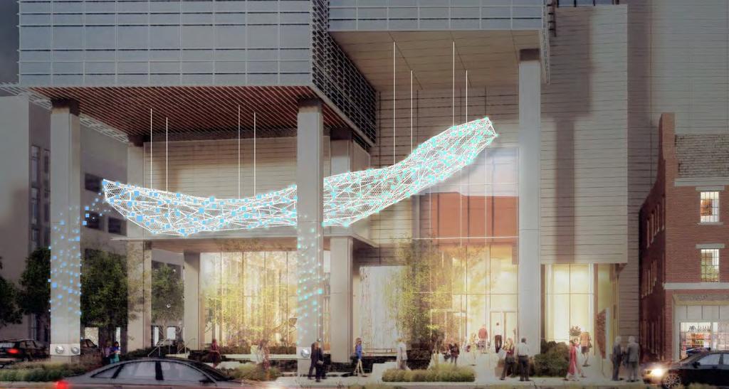
26 Public Art To visually occupy and focus the space between the ground plane and the soffit, the Applicant is proposing a dynamic, interactive public art work to be suspended within it. As the artist describes the proposal: The design resembles a living system that reflects the rhythms and energy of the site in what we are provisionally calling an interactive sculptural network. It is more than an art piece, the interactive sculptural network is an ever-changing and responsive experience that thrives through the synergy of urban culture, design innovation and social engagement. At different activation points, people will collaboratively influence the system to create new narratives, patterns and connections with the dynamic media. It will be designed so that visitors can engage with it and each other at multiple levels of engagement. The interactive sculptural network will provide an invitation to people to linger, explore and connect within the plaza. Figure 17 Art Location Plan Figures 18 and 19 on following pages Daytime and Evening Conceptual Views of Public Art 26
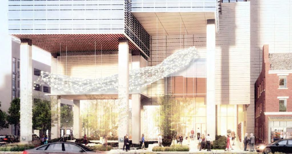
27 27
28 28
29 Access Transit Connectivity The immediate area is well served by transit that includes the Red Line Bethesda Metrorail Station (located approximately 500 feet to the northwest of the site), Metrobus, RideOn, the Bethesda Circulator and future Purple Line. Master Plan Roadways and Pedestrian/Bikeway Facilities The 2017 Bethesda Downtown Sector Plan recommends the following Sector Plan facilities along Property frontage: 1. Wisconsin Avenue, along the western site frontage, as a major highway (M-6) with a minimum right-ofway width of 122 feet. 2. Montgomery Avenue, along the northern site frontage, as a business district street with a minimum rightof-way width of 80 feet and separated bicycle lanes (Figure 20). 3. Waverly Street, along the eastern site frontage, as a business district street with a minimum right-of-way width of 60 feet. Figure 20: Montgomery Avenue Bicycle Facility, Section Sector-Planned Transportation Demand Management As a mixed-use project within the Bethesda Transportation Management District (TMD), the development will enter into a Traffic Mitigation Agreement (TMAg) with the Planning Board and Montgomery County Department of Transportation (MCDOT) to participate in the Bethesda TMD and contribute to the Sector Plan goal of 55% Non- Auto Driver Mode Share (NADMS), averaged between commuters and residents of the Downtown area. Parking Recommendations The Sector Plan recommends each application in downtown Bethesda promote a constrained parking policy that supports a transit-oriented downtown. The Project is providing parking below the minimum. The Applicant is receiving a 20 percent reduction in number of spaces required as part of its public benefits package. 29

30 Circulation As conditioned, the Project provides safe, adequate, and efficient circulation, parking, and loading for cars, trucks, pedestrians, and bicyclists and integrates the project into the surrounding area. The Project will be served by an on-site garage internal to the Project, containing approximately 500 parking spaces. Vehicular access for service, and loading are proposed as full-movement driveways directly from Waverly Street while the garage is proposed as a full-movement inbound and single-movement outbound lanes (Figure 21). This access configuration eliminates driveways on both Wisconsin Avenue and Montgomery Avenue and minimizes potential conflicts with pedestrians, cyclists and local vehicular traffic. Figure 21: Circulation Plan Issue: Garage Access Design Although there are many positive aspects to the site access concept proposed by the Applicant, Staff has conditioned that the garage access point on Waverly Street be reduced in width, from its currently proposed two outbound travel lanes and one inbound lane, to a single full-movement outbound lane and single full-movement inbound lane. The Project s Waverly Street façade measures 133. As proposed, 92 (69%) is dedicated to vehicular access points. Of that 92, 35.5 (27% of the Waverly Street frontage) is specifically dedicated to garage ingress/ egress with the remaining 56.5 (42%) allocated to loading/ service. As conditioned, the garage access will be narrowed to a maximum of 24 (18% of the total Waverly Frontage), resulting in a total of 80 (60%) allocated to vehicular access points. This modification would enhance pedestrian safety by limiting pedestrians exposure to potential conflict 30

31 points and reinforce the multi-modal nature of the Bethesda Downtown area. Furthermore, this modification constrains outbound vehicular turning movements, creating a stronger yield condition as cars cross the sidewalk and enter the Waverly Street travel way. Figure 22: Waverly Street Loading Detail 31
32 In response to Staff s request, the Applicant asserted that two outbound travel lanes are necessary for efficient garage operations and to reduce delay for those wishing to exit the Site by car. While a second outbound lane would increase the efficiency of garage egress, it would do so to the detriment of the pedestrian realm by increasing the number of potential vehicle movements and increase the potential for conflict between cars exiting the garage and cars traveling on Waverly Street, as well as pedestrians, and bicyclists. SECTION 4: SKETCH PLAN PROJECT ANALYSIS The purpose of a Sketch Plan is to identify general land uses, development intensity, and public benefits for the optional method of development in the CR, CRT, EOF or LSC Zones. The Sketch Plan is intended to be conceptual in nature with an emphasis on: building densities; massing; heights and anticipated uses; the locations of open and public use spaces; the general circulation patterns for all modes of transportation; an estimated range of peak hour trips; and relationships between existing or proposed adjacent buildings and rights-of-way. Details of the proposed development are determined during Preliminary and Site Plan reviews. PROJECT FINDINGS Section E of the Zoning Ordinance states: To approve a sketch plan, the Planning Board must find that the following elements are appropriate in concept and appropriate for further detailed review at site plan. The sketch plan must: 1. meet the objectives, general requirements, and standards of this Chapter; As discussed in the Site Plan findings below, the Sketch Plan meets all of the Development Standards of the CR 5.0, C 5.0, R 4.75, H 250. The intent of the CR Zone is to: a) Implement the recommendations of applicable master plans. OVERARCHING GOALS OF THE BETHESDA DOWNTOWN SECTOR PLAN Specifically, this Plan builds on the past successes of Downtown Bethesda to create a truly sustainable downtown by focusing on components that will bolster the elements most in need of enhancement. The recommendations increase: 1. Parks and open spaces, including new civic greens at Veteran s Park, Bethesda Farm Women s Cooperative Market, Capital Crescent Trail and new urban parks, pathways and gateways. 2. Affordable housing, including the preservation of existing market-rate affordable housing, providing a mix of housing options and the provision of Moderately Priced Dwelling Units in exchange for development incentives. 3. Environmental innovation, including more energy-efficient buildings, better stormwater management, improved sidewalks and bicycle routes, and other measures to enhance community health and quality of life. 4. Economic competitiveness, based on new development, public amenities and proximity to public transit to attract businesses and visitors from throughout the region, and foster entrepreneurship and innovation. 32
33 WISCONSIN AVENUE DISTRICT GOALS AND RECOMMENDATIONS: The Wisconsin Avenue Corridor is the main artery through the center of Downtown Bethesda. It extends from the Sector Plan Boundary/National Institutes of Health (NIH) on the north to Bradley Boulevard on the south, and from Woodmont Avenue on the west to Waverly Street on the east. With the existing Bethesda Metrorail Station, future Purple Line and bus rapid transit (BRT) options, Wisconsin Avenue is a critical focus area for improved access, mobility and pedestrian safety. The corridor is envisioned as a symbolic downtown center that reflects the character of adjacent neighborhoods and overall identity of Bethesda through innovative building designs and active public spaces. The Wisconsin Avenue Corridor is primarily a commercial area, containing both retail and office uses. Among its numerous large office buildings are older ones predating the 1976 Bethesda Central Business District Sector Plan, such as the Air Rights Building; 1980s structures; and buildings at the Bethesda Metrorail Station. The northern part of Wisconsin Avenue comprises several hotels, stores, restaurants and offices, but currently has no clear identity. The area s retail potential is compromised by its location on either side of Wisconsin Avenue. As a major commuter arterial, this street has heavy traffic volumes that eliminate the potential for cross shopping and a lack of visibility for retail establishments. However, Wisconsin North anticipates increased development activity with five planned projects, including the Harris Teeter site at 8300 Wisconsin Avenue. These projects will increase the employee, visitor and residential customer base within the district. The Metro Core of Wisconsin Avenue struggles with the same condition caused by the barrier of Wisconsin Avenue s width as well as its vehicular traffic volume and speed. Similar to northern Wisconsin Avenue, the area includes hotels, but is most noted for the density of office buildings that surround its Metrorail station and accessible roadways. Consequently, most of the existing retail offerings in the Metro Core are oriented to the Monday through Friday, 9-to-5 customer. As Bethesda Row and Woodmont Triangle have become increasingly more attractive as locations for new and/ or expanding retailers, these areas draw more and more customers away from the Metro Core s shops, restaurants and services. The Wisconsin Avenue Corridor, consistent with adopted planning principles, has the tallest buildings in Downtown Bethesda. Building heights step down from the 200-foot Clark Building to the surrounding 143-foot heights allowed in the Commercial Residential Zone (former Central Business District-2 Zone in the 1994 Bethesda Central Business District Sector Plan). Buildings at Bethesda and Wisconsin Avenues provide a gateway open space at the corner of this intersection. A number of potentially high-density sites remain to be developed in the area. Land Use and Zoning Goals: Encourage infill and reinvestment on underutilized commercial sites and private surface parking lots. Encourage mixed-income/affordable housing near transit stations. Provide zoning recommendations that allow signature tall buildings at major civic spaces in the established centers. Develop compact nodes that place the highest intensity in those centers, provide distinctive infill buildings and step down to lower densities and heights near the edges. Improve and enhance underutilized privately owned public use spaces. Provide new civic gathering spaces. Encourage high-performance buildings and sites nearest the established centers. 33
34 Improve the pedestrian environment with upgraded streetscapes. Land Use Recommendations: Create two new civic gathering spaces in the form of civic green space/parks at the Farm Women s Cooperative Market site and Veteran s Park Civic Green. Emphasize mixed land uses focused on employment and high density residential. Zoning Recommendations (Site Specific): ReZone Map #122 from its current Zones to increase the commercial density from 4.0 FAR to 5.0 FAR and increase the maximum allowable building height to 250 feet to provide flexible development opportunities and allow future development to better adapt to market conditions. This Application incorporates many of the land use and zoning recommendations of the Sector Plan by including: 1) commercial and compact development in the core area along Wisconsin Avenue in the highest intensity centers, providing for distinctive infill buildings; 2) zoning recommendations that allow signature tall buildings near public gathering areas; 3) buildings that step down to lower densities to the east; 4) incorporation of energy efficiency and high performance in both the hotel and office buildings; and 5) an emphasis on mixed land uses that guide future employment surrounded by both commercial and residential uses. The zoning approved for the Site through the Sectional Map Amendment (SMA) increases the base density to a total 5.0 FAR and increases the height to 250 feet. To reach the heights proposed, the Applicant is requesting an allocation of BOZ density in the amount of 214,795 square feet requiring a payment that would facilitate acquisition of parkland in the downtown. Urban Design Recommendations: Public Realm a. Goal: Create green, active and walkable sidewalks that are designed to balance pedestrian and retail activity with vehicular and BRT traffic along this major corridor. Recommendations: Provide a planting and furnishing buffer between sidewalks and street traffic. Ensure a clear pedestrian pathway. Allow space for various activities, such as outdoor dining in retail focus areas, and provide planting and seating along remaining sections of the street. b. Goal: Create major civic gathering spaces as the hinge between Wisconsin Avenue, Norfolk Avenue and Bethesda Avenue. Recommendations: Expand Veteran s Park through a new civic green bordered by a shared street that connects Wisconsin Avenue to Norfolk Avenue and Woodmont Triangle. This Application is improving the streetscape along Wisconsin Avenue and Montgomery Avenue consistent with the Bethesda Streetscape Standards. This includes new street trees, lights, paving, site furnishings and the undergrounding of utilities. The Applicant is providing between the tree pit and the building edge a minimum 19-foot clear pedestrian way along Wisconsin Avenue and a minimum 8-foot-wide clear pedestrian pathway along Montgomery Avenue. 34
35 Building Form a. Goal: Design tall buildings along Wisconsin Avenue to have a human-scaled presence on the street, reduced uniformity and compatibility with edge neighborhoods. Recommendations: Provide building articulation such as step backs, glazing and material changes. Provide building separation to ensure the design allows for light and air, and reduces shadows cast onto public spaces. b. Goal: Provide visual interest along the corridor by highlighting significant points with increased height. Recommendations: Provide increased height at the transit gateways to the Metrorail and Purple Line stations. Mark the Veteran s Park Civic Green as a major civic gathering space through signature buildings at this location. The building design modulates in form both horizontally and vertically, introducing mixes of materials and provides the intersection of Wisconsin Avenue and Montgomery Avenue with both a unique plaza at the ground level and an iconic architectural embellishment at the top. The design of the building provides a unique articulation to various building surfaces and provides an efficient use of the site in an urban environment. The form of the building is comprised of three major vertical masses interconnected by the podium. Each of the masses is defined by distinct architectural skins and steps down from west to east. The façade of the building, as well as the parking garage above, are clad with a series of plane changes and pedestrian-scaled architectural embellishments which serve to both define the base of the building as well as provide for a human-scaled pedestrian experience. The transition to the tower mass is marked by a series of stepping architectural features and culminates in the large building undercut at the corner, which holds the office tower a minimum of 45 feet above the entry plaza below. Each of the three vertical masses has its own unique top. The hotel mass to the east is articulated at the top by a small setback terrace and green roof. The central mass is defined by a variation and extension of the architectural cladding. The major office mass to the west is articulated by a rooftop terrace that can be occupied, capped by a functional architectural embellishment that wraps across the top of the terrace, down the south face of the westerly mass and as currently conceived is expressed again as an artistic soffit feature for the entry plaza. Transportation and Bicycle Recommendations: To enhance the existing transportation network, this Plan recommends complete streets improvements to the roadway network that increase the connectivity, safety and quality for all modes of transportation. Complete streets design principles refer to roadway treatments intended to accommodate multiple modes of transportation, including pedestrian, bicycle, vehicular and transit, within the same right-of-way. Due to the transit-oriented nature of Downtown Bethesda, future transportation improvements within the Sector Plan area should consider complete streets strategies as critical elements of the transportation network. A high-quality pedestrian network is essential to the success of transit-oriented communities because, unlike most other modes of transportation, pedestrian activity is about experiencing the community between points of origin and destination. Nearly all modes of transportation require that at least a portion of each trip be completed as a pedestrian; therefore, the quality of the pedestrian network is an important issue for most residents and commuters in Downtown Bethesda. 35
36 Overall Goals Enhance roadway accommodation of all users. Increase the use of non-auto driver travel. Implement new transit alternatives. Improve bicycle and pedestrian infrastructure. Expand the constrained parking policy. Montgomery Avenue (CT-9) - Separated Bike Lanes (ultimate); Bike Lanes (interim); Wisconsin Avenue to East-West highway. All roads in the Sector Plan area should be designed for shared use by motor vehicles and bicycles and are designated as shared roadways unless another higher quality bicycle facility is provided (e.g. bike lanes). These shared roadways are called out for wayfinding purposes. This Sector Plan recommends amending the practice of implementing shared roadways on wide travel lanes; Bicycles should operate on-road as vehicles where the prevailing roadway operation is characterized by low vehicular speed and volume. Parking Recommendations Promote a constrained parking policy that supports a transit-oriented downtown. Explore opportunities for co-location of public facilities on Parking Lot District properties and facilities. Co-location should be considered as existing facilities are evaluated for replacement and as the market allows for new mixed-use development. The Applicant contributes to the transportation network in downtown Bethesda and regionally by contributing to the separated bike lanes for Montgomery Avenue. A contribution is being made to provide one off-site bike share facility. Pedestrian circulation is improved with the implementation of streetscape along Wisconsin Avenue and Montgomery Avenue to encourage connectivity within the Wisconsin Avenue District and to other transit options. Environmental Recommendations: Urban Green - On private property, provide a minimum of 35 percent green cover, which may include singularly or a combination of the following: o Intensive green roof (6 inches or deeper) on 35 percent of rooftop. o o Tree canopy cover on 35 percent of landscape. A combination of tree canopy and intensive green roof for a total green cover of 35 percent or greater*. Install green roofs with at least 6 inches of soil depth allowing for greater stormwater treatment. Provide soil volumes for canopy trees of no less than 600 cubic feet. Montgomery Avenue is a recommended Canopy Corridor. Provide Canopy Street Trees along Montgomery Avenue 30 feet on center. Water - Integrate environmental site design strategies that provide multiple performance area benefits for water quality, habitat, health and aesthetic improvement. Some strategies include: Intensive green roofs (6 inches or greater to maximize water treatment). Reduce impervious cover to maximize stormwater infiltration and/or green space. Use permeable surfaces where feasible. 36
37 The Application is providing an intensive green roof beyond the recommended 6 inch soil depth and landscaping and green cover calculated on the site area to meet the 35 percent green cover requirement from the Sector Plan. The project incorporates Silva Cells to account for enhanced stormwater management and proper soil volumes for the proposed plant material. High Performance Area - An optional method project in the High Performance Area should be approved only if it achieves the maximum amount of public benefit points allowed for constructing buildings that exceed energy efficiency standards for the building type. To qualify for the maximum available points, any building that is located in whole or in part within the boundary of the High Performance Area would be required to exceed the current ASHRAE 90.1 standard by 15 percent. If the County adopts a building code with a different efficiency standard, a building in the High Performance Area should similarly exceed the minimum standard. The building are subject to the high-performance standards and will exceed the current ASHRAE 90.1 standards as recommended in the Sector Plan and the Bethesda Overlay Zone. Section Public Benefits in the CR Zone Top Priority Benefits in the CR Zone (Bethesda Downtown Sector Plan Specific): Affordable Housing Public Open Space High Performance Area and Enhanced Vegetated Roofs to Increase Green Cover Exceptional Design Minimum Parking The development is providing several of the top-priority public benefits, including Exceptional Design, Minimum Parking, and Energy Conservation. b) Target opportunities for redevelopment of single-use commercial areas and surface parking lots with a mix of uses. The development will redevelop three single-use buildings and surface parking areas within a new mixed-use development that will include office and hotel uses, with structured above- and belowgrade parking. c) Encourage development that integrates a combination of housing types, mobility options, commercial services, and public facilities and amenities, where parking is prohibited between the building and the street. The development deftly integrates office, hotel, and parking uses both vertically and horizontally within the building, while providing a unique public-art-driven public space, and sector-planned bike lanes along the Montgomery Avenue frontage. The development will provide parking within and below the building. d) Allows a flexible mix of uses, densities, and building heights appropriate to various settings to ensure compatible relationships with adjoining neighborhoods. 37
38 The mix of uses, density, and building height in the development design are compatible with the adjacent and nearby existing and planned commercial development, while taking advantage of the Wisconsin Avenue frontage to provide a signature building in this prominent location. e) Integrate an appropriate balance of employment and housing opportunities. The project provides 400,000 square feet of premium office space in Downtown Bethesda to attract existing area businesses looking to upgrade their facilities, as well as new businesses looking to take advantage of the combination of nearby housing, parks, transit, and amenities. While the development does not include housing opportunities per se, the hotel component will serve a similar function for neighborhood businesses. f) Standardize optional method development by establishing minimum requirements for the provision of public benefits that will support and accommodate density above the standard method limit. The Project will provide the required public benefits from eight categories and more than the required 100 points to achieve the desired incentive density above the standard method limit. In addition to the public benefits, the Applicant is also paying a significant park impact payment to the PIP for the acquisition of parkland in downtown Bethesda. 2. substantially conform with the recommendations of the applicable master plan; As discussed in Finding 1.a) above, the Project substantially conforms to the 2017 Bethesda Downtown Sector Plan. 3. satisfy any development plan or schematic development plan in effect on October 29, 2014; The site is not subject to a development plan or schematic development plan. 4. Under Section B.5, for a property where the zoning classification on October 29, 2014 was the result of a Local Map Amendment, satisfy any green area requirement in effect on October 29, 2014; any green area under this provision includes and is not in addition to any open space requirement of the property s zoning on October 30, 2014; The Property s zoning classification on October 29, 2014, was not a result of a Local Map Amendment. 5. achieve compatible internal and external relationships between existing and pending nearby development; While the development will occupy half of the block on which it sits, the design engages the streets by maximizing pedestrian and visual permeability along the primary frontages of Wisconsin Avenue and Montgomery Avenue. Along the Wisconsin Avenue frontage, the building presence forms a vertical element that signals the importance of the site at this crossroads intersection from a distance, while providing a public plaza at the sidewalk level that reinforces that importance with a destination-quality public artwork. For the longer Montgomery Avenue frontage, building entrances and façade modulation and transparency provide opportunities to connect to the building at the ground plane while the architectural articulation above relieves the potential monotony of a long façade with the appearance of several facades, providing interest and variety when viewed along the Avenue. 38
39 6. provides satisfactory general vehicular, pedestrian, and bicyclist access, circulation, parking, and loading; The site is surrounded by satisfactory circulation options. As conditioned, vehicular access for parking, service, and loading is provided from Waverly Street in a manner that is efficient enough to allow planting of much-desired street trees along that frontage, while maximizing pedestrian safety. A lay-by on Montgomery Avenue is integrated with the Sector-Planned bike lanes along that street. Pedestrian access on all three frontages will be enhanced with generally wider sidewalks and streetscape improvements. 7. propose an outline of public benefits that supports the requested incentive density and is appropriate for the specific community; As discussed further in the Site Plan findings below, and taking into account the considerations in Section B, including the recommendations and objectives of the Sector Plan and any applicable design guidelines, the Incentive Density Implementation Guidelines, the size and configuration of the site and its relationship to adjacent properties, similar public benefits nearby, and additional enhancements related to the individual public benefits, the provided public benefits support the Applicant s request for incentive density and is appropriate for the community surrounding the Site. 8. establish a feasible and appropriate provisional phasing plan for all structures, uses, rights-of-way, sidewalks, dedications, public benefits, and future preliminary and site plan applications. The development is expected to be constructed in one phase. SECTION 5: PRELIMINARY PLAN The layout of the subdivision, including size, width, shape, orientation and diversity of lots, and location and design of roads is appropriate for the subdivision given its location and the type of development or use contemplated and the applicable requirements of Chapter 59 The subdivision design is appropriate for the development. The lot was reviewed for compliance with the dimensional requirements for the CR Zone as specified in the Zoning Ordinance. The lot as proposed will meet all the dimensional requirements for area, frontage, width, and setbacks in that Zone. 2. The Preliminary Plan substantially conforms to the Master Plan or Urban Renewal Plan As discussion in Sketch Plan finding 1.a. above, the Preliminary Plan substantially conforms to the recommendations of the 2017 Bethesda Downtown Sector Plan ( Master Plan ). 3. Public Facilities will be adequate to support and service the area of the subdivision The Applicant submitted a transportation study was submitted on September 1, 2017, revised December 21, 2017, in response to agency comments. The proposed development is estimated to generate 774 new morning peak-hour person trips (370 vehicle trips) and 640 new evening peak-hour person trips (307 vehicle trips) (Table 1). Because of the estimated transportation impact of the Project exceeds 50 net new person trips in each of the following: total person trips, pedestrian trips, and bicycle trips, the Project is required to complete a transportation study that evaluates vehicular (intersection) capacity, pedestrian system adequacy, and bicycle system adequacy to satisfy the Local Area Transportation Review requirement. The Project is exempt from the transit system adequacy test because the Site is within 1,000 feet of a Metrorail Station. 39
40 Total Existing Table 1: Project Peak Hour Trip Generation Vehicle Rates Adjusted Vehicle Rates Person Trips Use Total Units/GFA AM PM AM PM AM PM Office 37,000 SF Police Station 16,200 SF Restaurant/Retail 8,000 SF Existing Subtotal Total Proposed Vehicle Rates Adjusted Vehicle Rates Person Trips Use Total Units/GFA AM PM AM PM AM PM Office 400,000 SF Hotel 225 Rooms Proposed Subtotal Net New Trips Source: Wells & Associates Transportation Study, dated December 21, Table 2: Peak Hour Trip Generation by Mode Person Trips Auto Driver Pedestrian* Transit Bike AM PM * Pedestrian trips are the sum of all transit and bicycle trips generated by the project. Source: Wells & Associates Transportation Study, dated December 21, As a project that generates more than 250 net new peak hour vehicle trips, the Applicant was required to evaluate a minimum of two tiers of intersections within Downtown Bethesda, resulting in a total of ten intersections evaluated as part of the Subject Application. In accordance with the Subdivision Staging Policy, eight of the ten intersections included in this analysis were evaluated as part of larger transportation corridors within the Downtown area under the Highway Capacity Manual (HCM) methodology. In addition to the typical HCM methodology analysis completed to satisfy the LATR, the Applicant also analyzed an alternative scenario in which the master planned separated bicycle lanes were implemented within an existing travel lane on Bethesda Avenue and Montgomery Avenue. The study locations and corridors are presented in Figure 23, below, and results of the HCM methodology are presented in Table 3. Each of the study area intersections/ corridors will continue to operate within acceptable limits of congestion following completion of the Project under either scenario. 40
 Intersection/Corridor AM PM AM PM AM PM AM PM Woodmont Avenue/ Elm Street 120 13.0 13.0 29.9 17.3 29.8 19.6 29.8 19.5 Wisconsin Avenue* 120 31.0 27.0 43.0 43.0 50.")
41 Figure 23: Intersection Analysis Map Table 3: Intersection Capacity Highway Capacity Manual Methodology Control Delay (seconds) Delay Standard Existing Conditions Background Conditions Future Conditions Future Conditions (Bike Lanes) Intersection/Corridor AM PM AM PM AM PM AM PM Woodmont Avenue/ Elm Street Wisconsin Avenue* East-West Highway* Montgomery Avenue* * Denotes a corridor analysis. Source: Wells & Associates Transportation Study, dated December 21, In determining pedestrian system adequacy, the Applicant must evaluate pedestrian infrastructure within 500-linear feet of the Site limits and will fix or fund all pedestrian facilities determined to be non-compliant with standards set forth by the Americans with Disabilities Act. The Applicant will submit an exhibit at the time of Certified Site Plan, for Staff approval, showing the location of all non-compliant pedestrian facilities and cost estimate for all improvements associated with the requirement. The scope of improvements to satisfy this requirement will generally be limited to the horizontal clear width, longitudinal slope and cross slope of public pedestrian pathways, sidewalks, curb ramps, and crosswalks. 41
MONTGOMERY COUNTY PLANNING DEPARTMENT THE MARYLAND NATIONAL CAPITAL PARK AND PLANNING COMMISSION
 MONTGOMERY COUNTY PLANNING DEPARTMENT THE MARYLAND NATIONAL CAPITAL PARK AND PLANNING COMMISSION MCPB Item No. Date: 5.3.18 8000 Wisconsin Avenue Sketch Plan No. 320180120 Matthew Folden, Planner Coordinator,
MONTGOMERY COUNTY PLANNING DEPARTMENT THE MARYLAND-NATIONAL CAPITAL PARK AND PLANNING COMMISSION
 MONTGOMERY COUNTY PLANNING DEPARTMENT THE MARYLAND-NATIONAL CAPITAL PARK AND PLANNING COMMISSION MCPB Item No. Date: 3.10.2016 Site Plan 820160040 Nora School Parker Smith, Planning Technician, Area 1,
MONTGOMERY COUNTY PLANNING DEPARTMENT THE MARYLAND-NATIONAL CAPITAL PARK AND PLANNING COMMISSION
 MONTGOMERY COUNTY PLANNING DEPARTMENT THE MARYLAND-NATIONAL CAPITAL PARK AND PLANNING COMMISSION MCPB Item No. Date: 10.25.18 Artery Plaza: Site Plan Amendment 81984002E SD Stephanie Dickel, Planner Coordinator,
MONTGOMERY COUNTY PLANNING DEPARTMENT THE MARYLAND-NATIONAL CAPITAL PARK AND PLANNING COMMISSION
 MONTGOMERY COUNTY PLANNING DEPARTMENT THE MARYLAND-NATIONAL CAPITAL PARK AND PLANNING COMMISSION MCPB Item No. Date: 12-10-15 Leisure World Clubhouse II Addition Fitness Center, Limited Site Plan Amendment
MONTGOMERY COUNTY PLANNING DEPARTMENT THE MARYLAND NATIONAL CAPITAL PARK AND PLANNING COMMISSION
 MONTGOMERY COUNTY PLANNING DEPARTMENT THE MARYLAND NATIONAL CAPITAL PARK AND PLANNING COMMISSION MCPB Item No. 7 Date: 7.19.18 ZOM Bethesda, Preliminary Plan No. 120180140 and Site Plan No. 820180120 Matthew
MONTGOMERY COUNTY PLANNING DEPARTMENT
 MONTGOMERY COUNTY PLANNING DEPARTMENT THE MARYLAND-NATIONAL CAPITAL PARK AND PLANNING COMMISSION MCPB Item No.: Date: 5-03-18 Pike and Rose, Phase I: Site Plan Amendment No. 82012002D Rhoda Hersson-Ringskog,
MONTGOMERY COUNTY PLANNING DEPARTMENT THE MARYLAND-NATIONAL CAPITAL PARK AND PLANNING COMMISSION
 MONTGOMERY COUNTY PLANNING DEPARTMENT THE MARYLAND-NATIONAL CAPITAL PARK AND PLANNING COMMISSION MCPB Item No. Date: 1/26/12 Hanover Shady Grove, Sketch Plan 320120020 Joshua Sloan, Coordinator, Joshua.Sloan@MontgomeryPlanning.org,
MONTGOMERY COUNTY PLANNING DEPARTMENT THE MARYLAND NATIONAL CAPITAL PARK AND PLANNING COMMISSION
 MONTGOMERY COUNTY PLANNING DEPARTMENT THE MARYLAND NATIONAL CAPITAL PARK AND PLANNING COMMISSION MCPB Item No. 8 Date: 3.30.2017 Project Name: Lot 31/31A Bethesda, Site Plan Amendment, No. 82007018C Elza
MONTGOMERY COUNTY PLANNING DEPARTMENT
 MONTGOMERY COUNTY PLANNING DEPARTMENT THE MARYLAND-NATIONAL CAPITAL PARK AND PLANNING COMMISSION MCPB Item No. Date: 04/05/2018 850 Sligo Avenue Sketch Plan No. 320180090 Neil Sullivan, Planner Coordinator,
MONTGOMERY COUNTY PLANNING DEPARTMENT Newell Street. Site Plan Item #2. Maryland-National Capital Park and Planning Commission
 8001 Newell Street Site Plan 820140020 Item #2 December 19, 2013 Redlined Conditions 1. The Applicant must comply with the conditions of approval for Project Plan 920130020 in MCPB Resolution No. 13-74.
MONTGOMERY COUNTY PLANNING DEPARTMENT THE MARYLAND NATIONAL CAPITAL PARK AND PLANNING COMMISSION
 MONTGOMERY COUNTY PLANNING DEPARTMENT THE MARYLAND NATIONAL CAPITAL PARK AND PLANNING COMMISSION MCPB Item No. 3 Date: 1.5.17 7272 Wisconsin Avenue: Sketch Plan Amendment No. 32016004A, Preliminary Plan
MONTGOMERY COUNTY PLANNING DEPARTMENT THE MARYLAND-NATIONAL CAPITAL PARK AND PLANNING COMMISSION
 MONTGOMERY COUNTY PLANNING DEPARTMENT THE MARYLAND-NATIONAL CAPITAL PARK AND PLANNING COMMISSION MCPB Item No. Date: 9/22/16 Ripley II: Sketch Plan Amendment No. 32015003A, Preliminary Plan No. 120160190,
MONTGOMERY COUNTY PLANNING DEPARTMENT THE MARYLAND-NATIONAL CAPITAL PARK AND PLANNING COMMISSION
 MONTGOMERY COUNTY PLANNING DEPARTMENT THE MARYLAND-NATIONAL CAPITAL PARK AND PLANNING COMMISSION MCPB Item No. 3 4/3/14 4990 Fairmont Avenue, Site Plan 820140060 Erin Banks, AICP, Senior Planner, Area
PROJECT NARRATIVE AND JUSTIFICATION STATEMENT
 7000 WISCONSIN AVENUE SKETCH PLAN NO. 320190090 PROJECT NARRATIVE AND JUSTIFICATION STATEMENT I. INTRODUCTION Starr Capital LLC and Woodfield Development Company (collectively, the Applicant ) are the
DRAFT. October Wheaton. Design Guidelines
 October 2011 DRAFT Wheaton Design Guidelines 2 Draft - Design Guidelines - Wheaton Sector Plan Contents 04 Section 1: Introduction 06 Section 2: Context 08 Section 3: Design Guidelines 09 Goal 1: Create
MONTGOMERY COUNTY PLANNING DEPARTMENT THE MARYLAND-NATIONAL CAPITAL PARK AND PLANNING COMMISSION
 MONTGOMERY COUNTY PLANNING DEPARTMENT THE MARYLAND-NATIONAL CAPITAL PARK AND PLANNING COMMISSION MCPB Item No.: 2 Date: 12-19-13 Site Plan 820140020, 8001 Newell Street Neil Braunstein, AICP, Area 1, neil.braunstein@montgomeryplanning.org,
MONTGOMERY COUNTY PLANNING DEPARTMENT THE MARYLAND-NATIONAL CAPITAL PARK AND PLANNING COMMISSION MCPB Item No.: 13 Date: 07/19/18
 MONTGOMERY COUNTY PLANNING DEPARTMENT THE MARYLAND-NATIONAL CAPITAL PARK AND PLANNING COMMISSION MCPB Item No.: 13 Date: 07/19/18 Black Hill / ViaSat: Project Plan No. 92012004B, Preliminary Plan No. 12012021B,
MONTGOMERY COUNTY PLANNING DEPARTMENT
 MONTGOMERY COUNTY PLANNING DEPARTMENT THE MARYLAND-NATIONAL CAPITAL PARK AND PLANNING COMMISSION Ourisman Ford at Montgomery Mall, Sketch Plan No. 320170100 MCPB Item No. Date: 11-30-17 LS Lori Shirley,
MONTGOMERY COUNTY PLANNING DEPARTMENT THE MARYLAND-NATIONAL CAPITAL PARK AND PLANNING COMMISSION
 MONTGOMERY COUNTY PLANNING DEPARTMENT THE MARYLAND-NATIONAL CAPITAL PARK AND PLANNING COMMISSION The Goddard School in North Bethesda Preliminary Plan Amendment 11996015B and Site Plan Amendment 82006005A
MONTGOMERY COUNTY PLANNING DEPARTMENT THE MARYLAND-NATIONAL CAPITAL PARK AND PLANNING COMMISSION
 MONTGOMERY COUNTY PLANNING DEPARTMENT THE MARYLAND-NATIONAL CAPITAL PARK AND PLANNING COMMISSION MCPB Item No. Date: 7/19/18 4 Bethesda Metro Center, Sketch Plan No. 320180110 SD Stephanie Dickel, Planner
MONTGOMERY COUNTY PLANNING DEPARTMENT THE MARYLAND-NATIONAL CAPITAL PARK AND PLANNING COMMISSION
 MONTGOMERY COUNTY PLANNING DEPARTMENT THE MARYLAND-NATIONAL CAPITAL PARK AND PLANNING COMMISSION MCPB Item Date: 09/08/16 The Collection (Formerly Chevy Chase Center): Site Plan Amendment No. 82001013C,
MONTGOMERY COUNTY PLANNING DEPARTMENT THE MARYLAND-NATIONAL CAPITAL PARK AND PLANNING COMMISSION
 MONTGOMERY COUNTY PLANNING DEPARTMENT THE MARYLAND-NATIONAL CAPITAL PARK AND PLANNING COMMISSION MCPB Item No. 4 7/18/13 4990 Fairmont Avenue, Project Plan 920130070 & Preliminary Plan 120130230 Erin Grayson,
Clarksburg Square Road Extension
 Clarksburg Square Road Extension Preliminary Plan No. 120140060 Site Plan No. 820140050 Site Plan Amendment No. 82007022C (Clarksburg Town Center) Clarksburg SPA Water Quality Plan Mandatory Referral MR2015008
MONTGOMERY COUNTY PLANNING DEPARTMENT THE MARYLAND NATIONAL CAPITAL PARK AND PLANNING COMMISSION
 MONTGOMERY COUNTY PLANNING DEPARTMENT THE MARYLAND NATIONAL CAPITAL PARK AND PLANNING COMMISSION MCPB Item No. 5 Date: 07/19/18 7607 Old Georgetown Road, Sketch Plan No. 320180160 Description Grace Bogdan,
Policies and Code Intent Sections Related to Town Center
 Policies and Code Intent Sections Related to Town Center The Town Center Vision is scattered throughout the Comprehensive Plan, development code and the 1994 Town Center Plan. What follows are sections
MONTGOMERY COUNTY PLANNING DEPARTMENT THE MARYLAND-NATIONAL CAPITAL PARK AND PLANNING COMMISSION
 MONTGOMERY COUNTY PLANNING DEPARTMENT THE MARYLAND-NATIONAL CAPITAL PARK AND PLANNING COMMISSION MCPB Item No. Date: 06-12-14 King of the Nations Christian Fellowship Church: Limited Site Plan Amendment
MONTGOMERY COUNTY PLANNING DEPARTMENT THE MARYLAND-NATIONAL CAPITAL PARK AND PLANNING COMMISSION
 MONTGOMERY COUNTY PLANNING DEPARTMENT THE MARYLAND-NATIONAL CAPITAL PARK AND PLANNING COMMISSION MCPB Item No. Date: 1/15/2015 Bethesda North Marriott Hotel and Conference Center: Limited Site Plan Amendment
MONTGOMERY COUNTY PLANNING DEPARTMENT THE MARYLAND-NATIONAL CAPITAL PARK AND PLANNING COMMISSION
 MONTGOMERY COUNTY PLANNING DEPARTMENT THE MARYLAND-NATIONAL CAPITAL PARK AND PLANNING COMMISSION 8015 Old Georgetown Road, Preliminary Plan 120160220, Site Plan 820160090 MCPB Item No.: 8 Date: 11-03-16
The subject site plan amendment proposes the following revisions to the approved site plan:
 PROPOSED AMENDMENT The subject site plan amendment proposes the following revisions to the approved site plan: 1. The building footprint was modified to accommodate the revised architectural design. 2.
MONTGOMERY COUNTY PLANNING DEPARTMENT THE MARYLAND-NATIONAL CAPITAL PARK AND PLANNING COMMISSION
 MONTGOMERY COUNTY PLANNING DEPARTMENT THE MARYLAND-NATIONAL CAPITAL PARK AND PLANNING COMMISSION MCPB Item No. Date10/25/12 Sketch Plan No. 32012004, White Flint Mall Redevelopment Nkosi Yearwood, Senior
The transportation system in a community is an
 7 TRANSPORTATION The transportation system in a community is an important factor contributing to the quality of life of the residents. Without a sound transportation system to bring both goods and patrons
I. Introduction. Prior Approvals
 Statement of Justification First National Bank 19790 Crystal Rock Drive, Germantown, Maryland Application for Site Plan and Limited Preliminary Plan Amendment I. Introduction DPH Architecture, for First
MONTGOMERY COUNTY PLANNING DEPARTMENT THE MARYLAND-NATIONAL CAPITAL PARK AND PLANNING COMMISSION
 MONTGOMERY COUNTY PLANNING DEPARTMENT THE MARYLAND-NATIONAL CAPITAL PARK AND PLANNING COMMISSION MCPB Item No. 6 Date: 5-9-13 Site Plan No. 820130090, West Chevy Chase Heights Erin Grayson, Senior Planner,
DRAFT Northeast Quadrant of Kipling Avenue and Highway 7 DRAFT AUGUST 29, Goals Land Use. The goals of this Plan are to:
 AUGUST 29, 2017 12.15 Northeast Quadrant of Kipling Avenue and Highway 7 12.15.1 Goals 12.15.2 Land Use The goals of this Plan are to: 12.15.2.1 General Provisions: a) Ensure the development of a compact
MONTGOMERY COUNTY PLANNING DEPARTMENT THE MARYLAND-NATIONAL CAPITAL PARK AND PLANNING COMMISSION
 MONTGOMERY COUNTY PLANNING DEPARTMENT THE MARYLAND-NATIONAL CAPITAL PARK AND PLANNING COMMISSION MCPB Item No. Date: 12/11/2014 Ripley East Sketch Plan No. 320150010 SD Stephanie Dickel, Planner Coordinator,
MONTGOMERY COUNTY PLANNING DEPARTMENT THE MARYLAND-NATIONAL CAPITAL PARK AND PLANNING COMMISSION
 MONTGOMERY COUNTY PLANNING DEPARTMENT THE MARYLAND-NATIONAL CAPITAL PARK AND PLANNING COMMISSION Staff Report: Sketch Plan #320110010, Mid-Pike Plaza ITEM #: MCPB HEARING DATE: January 20, 2011 REPORT
MONTGOMERY COUNTY PLANNING DEPARTMENT THE MARYLAND-NATIONAL CAPITAL PARK AND PLANNING COMMISSION
 MONTGOMERY COUNTY PLANNING DEPARTMENT THE MARYLAND-NATIONAL CAPITAL PARK AND PLANNING COMMISSION MCPB Item No. 6 Date: 7.22.13 Bethesda Purple Line Station Minor Master Plan Amendment, Scope of Work Elza
ARTICLE 6: Special and Planned Development Districts
 ARTICLE 6: Special and Planned Development Districts 6-10 Traditional Neighborhood Development (TND) District 6-10.10 Purpose and Intent The Traditional Neighborhood Development (TND) District provides
PROJECT NARRATIVE AND JUSTIFICATION STATEMENT
 8000 WISCONSIN AVENUE SKETCH PLAN NO. 320180120 PROJECT NARRATIVE AND JUSTIFICATION STATEMENT I. INTRODUCTION Aksoylu Properties (the Applicant ) is the contract purchaser of 7938, 7940, 7942, and 8000
MONTGOMERY COUNTY PLANNING DEPARTMENT THE MARYLAND-NATIONAL CAPITAL PARK AND PLANNING COMMISSION
 MONTGOMERY COUNTY PLANNING DEPARTMENT THE MARYLAND-NATIONAL CAPITAL PARK AND PLANNING COMMISSION MCPB Item No. Date: 05/12/2016 North Bethesda Conference Center Parking Structure, Mandatory Referral No.
12 January 12, 2011 Public Hearing APPLICANT: TAILWIND DEVELOPMENT GROUP,LLC PROPERTY OWNER: CITY OF VIRGINIA BEACH
 12 January 12, 2011 Public Hearing APPLICANT: TAILWIND DEVELOPMENT GROUP,LLC PROPERTY OWNER: CITY OF VIRGINIA BEACH STAFF PLANNER: Faith Christie REQUEST: Conditional Change of Zoning (from PD-H1 Planned
MONTGOMERY COUNTY PLANNING DEPARTMENT THE MARYLAND-NATIONAL CAPITAL PARK AND PLANNING COMMISSION
 MONTGOMERY COUNTY PLANNING DEPARTMENT THE MARYLAND-NATIONAL CAPITAL PARK AND PLANNING COMMISSION MCPB Item No. Date: 7/30/2015 Pooks Hill Sketch Plan No. 320150060 Kathleen A. Reilly, AICP Planner Coordinator,
Wheaton CBD & Vicinity Sector Plan D E S I G N G U I D E L I N E S
 Wheaton CBD & Vicinity Sector Plan D E S I G N G U I D E L I N E S 1 a b s t r a c t This document contains the design guidelines the property owners, community members, and planners should use to implement
REQUEST Current Zoning: O-15(CD) (office) Proposed Zoning: TOD-M(CD) (transit oriented development mixed-use, conditional)
 (office) Proposed Zoning: TOD-M(CD) (transit oriented development mixed-use, conditional)") Rezoning Petition 2016-117 Zoning Committee Recommendation January 4, 2017 REQUEST Current Zoning: O-15(CD) (office) Proposed Zoning: TOD-M(CD) (transit oriented development mixed-use, conditional) LOCATION
Rezoning Petition 2016-117 Zoning Committee Recommendation January 4, 2017 REQUEST Current Zoning: O-15(CD) (office) Proposed Zoning: TOD-M(CD) (transit oriented development mixed-use, conditional) LOCATION
Planning Board Briefing
 Planning Board Briefing Why Now? The Sector Plan Implementation Chapter States: Before Stage 1 begins, the following must occur: Approval of the Sectional Map Amendment. Approval of the Greater Lyttonsville
Town Center (part of the Comprehensive Plan)
") Town Center (part of the Comprehensive Plan) Mercer Island Town Center Looking North (2014) In 1994, a year-long process culminated in a set of design guidelines and code requirements for the Town Center
Town Center (part of the Comprehensive Plan) Mercer Island Town Center Looking North (2014) In 1994, a year-long process culminated in a set of design guidelines and code requirements for the Town Center
MONTGOMERY COUNTY PLANNING DEPARTMENT THE MARYLAND-NATIONAL CAPITAL PARK AND PLANNING COMMISSION
 MONTGOMERY COUNTY PLANNING DEPARTMENT THE MARYLAND-NATIONAL CAPITAL PARK AND PLANNING COMMISSION MCPB Item No. 8 Date: 12-15-16 Montgomery Village Center Sketch Plan No. 320170020 TL Troy Leftwich, Senior
Executive Summary. NY 7 / NY 2 Corridor
 Executive Summary NY 7 / NY 2 Corridor Transportation and Land Use Study December 2005 Prepared for: Town of Colonie Capital District Transportation Committee Prepared by: Introduction: Land use decisions
MONTGOMERY COUNTY PLANNING DEPARTMENT THE MARYLAND-NATIONAL CAPITAL PARK AND PLANNING COMMISSION
 MONTGOMERY COUNTY PLANNING DEPARTMENT THE MARYLAND-NATIONAL CAPITAL PARK AND PLANNING COMMISSION Montgomery Auto Sales Park: Preliminary Plan No. 11985027A, Site Plan No. 820140130 and Site Plan No. 820140140
ARLINGTON COUNTY, VIRGINIA
 ARLINGTON COUNTY, VIRGINIA County Board Agenda Item Meeting October 15, 2005 DATE: September 28, 2005 SUBJECT: Request to Advertise the adoption of the 2005 Clarendon Sector Plan C. M. RECOMMENDATION:
MONTGOMERY COUNTY PLANNING DEPARTMENT
 MONTGOMERY COUNTY PLANNING DEPARTMENT THE MARYLAND-NATIONAL CAPITAL PARK AND PLANNING COMMISSION North Bethesda Town Center Parcel G Site Plan No. 820180010 MCPB Item No.: Date: 01-25-18 Atul Sharma, Planner
Gold Line Bus Rapid Transit Transit Oriented Development (BRTOD) Helmo Station Area Plan
 Helmo Station Area Plan") Appendix F Gold Line Bus Rapid Transit Transit Oriented Development (BRTOD) Helmo Station Area Plan Introduction and Purpose of the Plan The Gold Line Bus Rapid Transit facility is an eleven-mile dedicated
Appendix F Gold Line Bus Rapid Transit Transit Oriented Development (BRTOD) Helmo Station Area Plan Introduction and Purpose of the Plan The Gold Line Bus Rapid Transit facility is an eleven-mile dedicated
Sketch Plan. MNCPPC Plan No: A
 General Notes 1. The Sketch Plan drawings are conceptual only and represent proposed development in an illustrative manner. Final building locations, dimensions, heights, uses and development standards
Hockessin Community Redevelopment Plan
 Hockessin Community Redevelopment Plan 3.1 Introduction The Community Redevelopment Plan for the Village of Hockessin is the result of the people s vision for a distinct village center that serves as the
THE 355/270 CORRIDOR:
 THE 355/270 CORRIDOR: Strategic Ideas for Sustaining a Livable Work Place Project Summary ACCESS LIFE DESIGN HEALTH WORK Montgomery County Planning Department The Maryland-National Capital Park and Planning
The Maryland-National Capital Park and Planning Commission Prince George's County Planning Department Development Review Division
 The Maryland-National Capital Park and Planning Commission Prince George's County Planning Department Development Review Division 301-952-3530 Note: Staff reports can be accessed at www.mncppc.org/pgco/planning/plan.htm.
Town Center. Block 5 Existing multifamily residential units are expected to remain.
 Area Guidelines Germantown s districts should be developed as distinct communities with unique features that are supported through the guidelines. The guidelines not only help distinguish these districts
ELMVALE ACRES SHOPPING CENTRE MASTER PLAN
 ELMVALE ACRES SHOPPING CENTRE MASTER PLAN Contents 1.0 INTRODUCTION... 2 2.0 LOCATION... 2 3.0 EXISTING CONTEXT... 2 4.0 VISION & GUIDING PRINCIPLES... 2 5.0 LAND USE AND BUILT FORM... 4 5.1 St. Laurent
MONTGOMERY COUNTY PLANNING DEPARTMENT THE MARYLAND-NATIONAL CAPITAL PARK AND PLANNING COMMISSION
 MONTGOMERY COUNTY PLANNING DEPARTMENT THE MARYLAND-NATIONAL CAPITAL PARK AND PLANNING COMMISSION MCPB Item No. Date: 05-22-14 Consent Item - Park Potomac: Site Plan Amendment No. 82004015K MCS. Molline
M E M O R A N D U M July 27, 2018
 M E M O R A N D U M July 27, 2018 To: Southlake 2035 Corridor Planning Committee From: Kenneth Baker, Sr. Director of Planning and Development Services Subject: Item #6 First National Bank Purpose Review,
STATEMENT OF JUSTIFICATION CLARKSBURG PREMIUM OUTLETS AT CABIN BRANCH NORTH DISTRICT, PHASE
 STATEMENT OF JUSTIFICATION CLARKSBURG PREMIUM OUTLETS AT CABIN BRANCH NORTH DISTRICT, PHASE 1 Southwest Corner of Clarksburg Road and Interstate-270 Clarksburg, Maryland Application for Site Plan #820140160
Agenda. 3. Outstanding Items. How it would work (DRP) Urban Design Guidelines language in Sector Plan (Concepts) vs. Guidelines Document (Detail)
 Urban Design Guidelines language in Sector Plan (Concepts) vs. Guidelines Document (Detail)") Work Session #14 Planning Board June 9, 2016 Agenda 1. Big Picture Items to Confirm Upfront 2. Detailed Topics for Conversation a) Park Impact Payment b) Priority Sending Sites - Additional Incentives
Work Session #14 Planning Board June 9, 2016 Agenda 1. Big Picture Items to Confirm Upfront 2. Detailed Topics for Conversation a) Park Impact Payment b) Priority Sending Sites - Additional Incentives
Clairtrell Area Context Plan
 Clairtrell Area Context Plan March 2005 Urban Development Services City Planning Contents 1. Introduction... 4 2. Development Structure... 6 2.1 Streets... 7 2.1.1 Sheppard Avenue and Bayview Avenue...
Description. Summary. MCPB Item No. Date: 01/17/13. Bethesda Crescent, Limited Site Plan Amendment, A, A
 THE MARYLAND-NATIONAL CAPITAL PARK AND PLANNING COMMISSION MCPB Item No. Date: 01/17/13 Bethesda Crescent, Limited Site Plan Amendment, 81984005A, 81984003A Parag Agrawal, Senior Planner, parag.agrawal@montgomeryplanning.org,
MONTGOMERY COUNTY PLANNING DEPARTMENT THE MARYLAND-NATIONAL CAPITAL PARK AND PLANNING COMMISSION
 MONTGOMERY COUNTY PLANNING DEPARTMENT THE MARYLAND-NATIONAL CAPITAL PARK AND PLANNING COMMISSION MCPB Item No.: 9 Date: 07-20-17 Topgolf - Germantown: Preliminary Plan Amendment No. 12007065B and Site
COUNTY COUNCIL OF PRINCE GEORGE'S COUNTY, MARYLAND, SITTING AS THE DISTRICT COUNCIL ORDER AFFIRMING PLANNING BOARD DECISION, WITH AMENDED CONDITIONS
 Case No. Applicant: Dawn Limited Partnership COUNTY COUNCIL OF PRINCE GEORGE'S COUNTY, MARYLAND, SITTING AS THE DISTRICT COUNCIL ORDER AFFIRMING PLANNING BOARD DECISION, WITH AMENDED CONDITIONS IT IS HEREBY
The Development Review Process. Presentation to the GSSC IAC
 The Development Review Process Presentation to the GSSC IAC July 19, 2011 Regulatory Processes in the Planning Department Natural Resource Inventory/Forest Stand Delineation Zoning (Development Plan) Special
MONTGOMERY COUNTY PLANNING DEPARTMENT THE MARYLAND-NATIONAL CAPITAL PARK AND PLANNING COMMISSION
 MONTGOMERY COUNTY PLANNING DEPARTMENT THE MARYLAND-NATIONAL CAPITAL PARK AND PLANNING COMMISSION MCPB Item No.: 8 Date: 9-19-13 Bethesda Commerce, Limited Preliminary & Site Plan, 120130240 & 820130240
MONTGOMERY COUNTY PLANNING DEPARTMENT THE MARYLAND-NATIONAL CAPITAL PARK AND PLANNING COMMISSION
 MONTGOMERY COUNTY PLANNING DEPARTMENT THE MARYLAND-NATIONAL CAPITAL PARK AND PLANNING COMMISSION Gables White Flint, Preliminary Plan No. 120150010 and Site Plan No. 820150010 MCPB Item No. Date: 4/30/2015
Statement of Justification for Sketch Plan Application No BETHESDA MARKET
 Statement of Justification for Sketch Plan Application No. 320190030 BETHESDA MARKET 7121 WISCONSIN AVENUE, 7126 WISCONSIN AVENUE, 7140 WISCONSIN AVENUE, 4705 MILLER AVENUE, FARM WOMEN'S COOPERATIVE MARKET
Ripley East. Sketch Plan Amendment No A Preliminary Plan No Site Plan No MONTGOMERY COUNTY PLANNING DEPARTMENT
 Ripley East Sketch Plan Amendment No. 32015001A Preliminary Plan No. 120150220 Site Plan No. 820150130 Planning Board Hearing Date: December 3, 2015 Site Vicinity and Site Description Silver Spring Transit
MONTGOMERY COUNTY PLANNING DEPARTMENT
 MONTGOMERY COUNTY PLANNING DEPARTMENT THE MARYLAND-NATIONAL CAPITAL PARK AND PLANNING COMMISSION MCPB Consent Date: 4-26-18 Cabin John Auto Park (N. Bethesda Home Depot), Site Plan Amendment No. 81980017A
Transportation. Strategies for Action
 Transportation A major priority for the Overlake Neighborhood is to develop a multimodal transportation system. To achieve this system, a balance has to be found among travel, circulation and access needs;
4.1.3 LAND USE CATEGORIES
 4.1.3 LAND USE CATEGORIES a. City Center District The City Center District incorporates the existing character and mix of uses in downtown Belmont to encourage redevelopment and new development in keeping
COMMUNITY DESIGN. GOAL: Create livable and attractive communities. Intent
 COMMUNITY DESIGN Intent An attractive, well-designed County will attract quality development, instill civic pride, improve the visual character of the community, and create a strong, positive image for
CITY OF MERCER ISLAND DESIGN COMMISSION STAFF REPORT
 CITY OF MERCER ISLAND DESIGN COMMISSION STAFF REPORT Agenda Item: 2 March 9, 2011 Project: Description: Applicant: DSR11-004 The applicant is requesting approval to replace the existing exterior wood framed
Design Review Application *Please call prior to submittal meeting to determine applicable fees*
 CITY OF EAGLE 660 E. Civic Lane, Eagle, ID 83616 Phone#: (208) 939-0227 Fax: (208) 938-3854 Design Review Application *Please call prior to submittal meeting to determine applicable fees* FILE NO.: CROSS
Seneca Meadows. Block 4 Locate office, technology, and medical development adjacent to I Screen views of garage structures from I-270.
 Seneca Meadows Seneca Meadows has an industrial park in its southern end and a mixed-use employment area planned for the north end. The district benefits from extensive I-270 visibility, stream valley
MONTGOMERY COUNTY PLANNING DEPARTMENT
 MONTGOMERY COUNTY PLANNING DEPARTMENT THE MARYLAND-NATIONAL CAPITAL PARK AND PLANNING COMMISSION 6000 Executive Boulevard, Sketch Plan No. 320180140 MCPB Item No. Date: 06/21/2018 Emily Tettelbaum, Senior
VILLAGE OF CLEMMONS PLANNING BOARD DRAFT STAFF REPORT
 VILLAGE OF CLEMMONS PLANNING BOARD DRAFT STAFF REPORT PETITION INFORMATION Docket # C-226 Staff Megan Ledbetter Petitioner(s) JBJH Properties, LLC Owner(s) JBJH Properties, LLC Subject Property 5892-49-1766
D1 September 11, 2013 Public Hearing APPLICANT:
 D1 September 11, 2013 Public Hearing APPLICANT: BEACH MUNICIPAL FEDERAL CREDIT UNION PROPERTY OWNER: SISTERS II, LLC STAFF PLANNER: Karen Prochilo REQUEST: Conditional Change of Zoning (AG-2 Agriculture
MONTGOMERY COUNTY PLANNING DEPARTMENT THE MARYLAND-NATIONAL CAPITAL PARK AND PLANNING COMMISSION
 MONTGOMERY COUNTY PLANNING DEPARTMENT THE MARYLAND-NATIONAL CAPITAL PARK AND PLANNING COMMISSION Preliminary Plan 120120220 & Site Plan 820120140, 7001 Arlington Road MCPB Item No. 8 Date: 11-1-12 Erin
TABLE OF CONTENTS 1.0 INTRODUCTION... 3
 TABLE OF CONTENTS 1.0 INTRODUCTION... 3 1.1. BACKGROUND... 3 1.2. THE PROPOSAL... 5 2.0 EXISTING POLICY FRAMEWORK... 5 2.1. PROVINCIAL POLICY STATEMENT (PPS)... 5 2.2. CITY OF LONDON OFFICIAL PLAN (OP)...
Welcome. Walk Around. Talk to Us. Write Down Your Comments
 Welcome This is an information meeting introducing the applications for proposed redevelopment of the Yorkdale Shopping Centre site at 3401 Dufferin Street and 1 Yorkdale Road over the next 20+ years,
Community Design Plan
 Gardena General Plan 2006 Authority While the is not a required element of a General Plan, it is included because improving the community appearance and image is paramount to the overall quality of life
MONTGOMERY COUNTY PLANNING DEPARTMENT THE MARYLAND-NATIONAL CAPITAL PARK AND PLANNING COMMISSION
 MONTGOMERY COUNTY PLANNING DEPARTMENT THE MARYLAND-NATIONAL CAPITAL PARK AND PLANNING COMMISSION MCPB Item No. Date: 04/24/2014 Sketch Plan No. 320140020, AVA Wheaton Michael Brown, Planner Coordinator,
Bethesda Downtown Design Advisory Panel Submission Form
 Bethesda Downtown Design Advisory Panel Submission Form PROJECT INFORMATION Project Name File Number(s) Project Address Plan Type Concept Plan Sketch Plan Site Plan APPLICANT TEAM Primary Contact Architect
MONTGOMERY COUNTY PLANNING DEPARTMENT
 MONTGOMERY COUNTY PLANNING DEPARTMENT THE MARYLAND-NATIONAL CAPITAL PARK AND PLANNING COMMISSION MCPB Item # Date: 9-6-18 Ourisman Ford at Montgomery Mall, Site Plan No. 82009014B Emily Tettelbaum, Planner
Westwood Shopping Center Sketch Plan, Plan # February 23, 2017 Item # 9
 Westwood Shopping Center Sketch Plan, Plan # 320170010 February 23, 2017 Item # 9 Westwood II Site 64,111 s.f. Manor Care site: vacant two story building HOC-Westwood Towers, 15 story tower To be considered
The Village. Chapter 3. Mixed Use Development Plan SPECIFIC PLAN
 The Village SPECIFIC PLAN Chapter 3 3.1 INTRODUCTION 3.1.1 Purpose This Chapter describes the development regulations applicable to the Mixed-Use and Transit Center Planning Areas. These form-based regulations
COMMERCIAL DESIGN REVIEW APPLICATION
 CITY OF LACEY Community Development Department 420 College Street Lacey, WA 98503 (360) 491-5642 COMMERCIAL DESIGN REVIEW APPLICATION OFFICIAL USE ONLY Case Number: Date Received: By: Related Case Numbers:
4 Bethesda Metro Center, Bethesda, Maryland Statement of Justification Sketch Plan
 I. Introduction 4 Bethesda Metro Center, Bethesda, Maryland Statement of Justification Sketch Plan BOP Bethesda Metro Center LLC, an affiliate of Brookfield Property Partners (the "Applicant") is submitting
Regency Developments. Urban Design Brief. Holyrood DC2 Rezoning
 Regency Developments Urban Design Brief Holyrood DC2 Rezoning Stantec Consulting Ltd. 7-31-2017 1. Overview Regency Developments intends to rezone the lands located at 8510 and 8511 93 Avenue, within the
MONTGOMERY COUNTY PLANNING DEPARTMENT
 MONTGOMERY COUNTY PLANNING DEPARTMENT THE MARYLAND-NATIONAL CAPITAL PARK AND PLANNING COMMISSION MCPB Item No. 4 Date: 12-15-16 CVS Derwood: Site Plan No. 820160150 Calvin Nelson, Jr., Planner Coordinator,
Status Report: MD 355 Project
 Status Report: MD 355 Project OCTOBER 2006 M-NCPPC MONTGOMERY COUNTY PLANNING DEPARTMENT Summary of Community Comments, and break to the Results of the MD 355 Participation Session Brookside Gardens -
CRYSTAL CITY BLOCK PLAN # CCBP- G 1 DRAFT
 CRYSTAL CITY BLOCK PLAN # CCBP- G 1 DRAFT BLOCK G (Metro Market Square block) Long Range Planning Committee Meeting January 29, 2018 1 1. Introduction 2 1. LRPC Meeting Purpose Review of proposed Crystal
MONTGOMERY COUNTY PLANNING DEPARTMENT THE MARYLAND-NATIONAL CAPITAL PARK AND PLANNING COMMISSION
 MONTGOMERY COUNTY PLANNING DEPARTMENT THE MARYLAND-NATIONAL CAPITAL PARK AND PLANNING COMMISSION Ashton Market: Preliminary Plan No. 120180180 and Site Plan No. 820180160 Jonathan Casey, Senior Planner,
Project Name: MELWOOD HOTEL. Date Accepted: 1/12/04. Waived. Planning Board Action Limit: Plan Acreage: 1.7 Zone: Dwelling Units:
 The Maryland-National Capital Park and Planning Commission Prince George's County Planning Department Development Review Division 301-952-3530 Note: Staff reports can be accessed at www.mncppc.org/pgco/planning/plan.htm.
MONTGOMERY COUNTY PLANNING DEPARTMENT THE MARYLAND-NATIONAL CAPITAL PARK AND PLANNING COMMISSION
 MONTGOMERY COUNTY PLANNING DEPARTMENT THE MARYLAND-NATIONAL CAPITAL PARK AND PLANNING COMMISSION MCPB Item No. Date: 11-16-17 Hillandale Gateway, Sketch Plan, 320180020 Summary Lori Shirley, Planner Coordinator,
Preliminary Recommendations Tk Takoma/Langley Crossroads Sector Plan
 Preliminary Recommendations Tk Takoma/Langley Crossroads Sector Plan Vision is to achieve a Transit Oriented, pedestrian friendly Community that Celebrates and builds upon the cultural Diversity of the