MONTGOMERY COUNTY PLANNING DEPARTMENT THE MARYLAND-NATIONAL CAPITAL PARK AND PLANNING COMMISSION
|
|
|
- Cody Richard
- 5 years ago
- Views:
Transcription

1 MONTGOMERY COUNTY PLANNING DEPARTMENT THE MARYLAND-NATIONAL CAPITAL PARK AND PLANNING COMMISSION Preliminary Plan & Site Plan , 7001 Arlington Road MCPB Item No. 8 Date: Erin Grayson, Senior Planner, Area 1, erin.grayson@montgomeryplanning.org, Robert A. Kronenberg, Acting Chief, Area 1, robert.kronenberg@montgomeryplanning.org, Description Applicant: AERC 7001 Arlington Road, LLC Prop. Address: 7001 Arlington Road, Bethesda Zone: PD-44 Master Plan: Bethesda CBD Sector Plan Filing Date: April 26, 2012 Summary The applicant, AERC 7001 Arlington Road, LLC, seeks approval of a preliminary plan and site plan located at 7001 Arlington Road in Bethesda. The proposal requires the consolidation of three parcels into one lot. The proposal includes 140 multi-family dwelling units, including 15% MPDUs as well as 7,000 square feet of retail space along the Arlington Road property frontage. A United States Postal Service facility was located on the property in the past, but due to the continuing consolidation policies of the Postal Service, a facility in this location was no longer feasible. The property was approved for rezoning to the PD-44 zone by the County Council in November 2008 and the applicant filed DPA 11-4 in August of 2011, which was ultimately approved by the Council in January These applications comply with the binding elements included in DPA 11-4 and meet all required preliminary and site plan findings.
2 TABLE OF CONTENTS SECTION 1: CONTEXT & PROPOSAL 3 Site Description 3 Vicinity 3 Site Analysis 4 Project Description 5 Previous approvals 5 Proposal 6 Community Outreach 7 SECTION 2: PRELIMINARY PLAN REVIEW 8 Findings 8 Recommendation and Conditions 15 SECTION 3: SITE PLAN REVIEW 17 Findings 17 Recommendation and Conditions 27 APPENDICES 30 ILLUSTRATIONS & TABLES Vicinity Map 3 Aerial Photograph 5 Preliminary Plan 8 Fire Access Exhibit 11 Site Plan Data Table 18 Garage Level Floor Plan 20 Illustrative rendering of the open spaces and amenity areas 21 Landscape Plan 22 Recreation Calculations Tables 22 Building Elevations 24

3 SECTION 1: CONTEXT AND PROPOSAL SITE DESCRIPTION Vicinity The subject property is located at 7001 Arlington Road in Bethesda, in the block between Bethesda Avenue and Bradley Boulevard. The property currently consists of three recorded parcels and is home to a United States Postal Service facility. Local Map Amendment G-861 rezoned the Property from C-4 to PD-44 (Planned Development) in Zoning Map Page 2
4 The predominant land use in the surrounding area is commercial, containing a mix of uses. The subject property abuts commercial properties in the C-2 Zone such as a tire store and an auto dealership to the north, and an office and retail complex with multiple buildings and parking garage to the south. Further north are additional retail and mixed use developments along Bethesda Avenue and Elm Street. To the west of the site, across Arlington Road, is the Bradley Shopping Center, which is zoned C-2 and contains a variety of retail establishments including a hardware store, a variety store, a drug store and a delicatessen. To the east, the subject property abuts the Capital Crescent Trail, a 90-foot wide public right-of-way containing a paved walking and biking trail. In the vicinity of the subject site, the Trail consists of a 10-foot wide asphalt path and a three-foot wide stone-edge path, as well as a landscaped seating area with benches and a water fountain that serves as a trailhead for the Bethesda Central Business District (CBD). On the east side of the Trail is a community of one-family detached homes known as the Sacks neighborhood, which is classified under the R-60 Zone. The boundary of the Bethesda CBD is approximately 600 east of the site, and the Bethesda Metro Station is approximately 1,800 feet northeast of the site. Site Analysis The subject property consists of three recorded parcels totaling approximately 2.7 acres. The site is irregular in shape, with about 277 feet of street frontage on Arlington Road, and extends 487 feet along its northern property line and 423 feet along its southern property line to the eastern property boundary that borders Capital Crescent Trail right-of-way. The majority of the site is impervious, and is currently developed with a United States Postal Service (USPS) facility, which includes a large surface parking lot and one entrance driveway along Arlington Road near the northern property line. The elevation rises about ten feet from the southwest corner of the site to the northeast corner. Vegetation is limited to a small lawn area with ornamental trees on the west side of the building, and several areas on the north and east sides of the parking lot with scrub vegetation. The site has no forest, streams, wetlands or specimen and significant trees. Page 3

5 Aerial Photo with site boundary outlined in red PROJECT DESCRIPTION Previous Approvals The initial application, G-861, was filed in November After multiple hearings and substantial public testimony, including a remand procedure, the Council ultimately approved the PD-44 Zone on the property in November 2008 for 105 dwelling units and 30,000 square feet of commercial space. The 30,000 square feet of commercial space on the site was comprised entirely of USPS uses, however, due to the continuing consolidation policies of USPS, having a post office facility integrated into the mixed use development on the subject property was no longer feasible. For this reason and due to economic and housing market changes, the applicant filed DPA 11-4 in August of The DPA reduced the amount of commercial space on the site from 30,000 square feet to 7,000 square feet to accommodate ground floor retail and increased the number of dwelling units from 105 to 145. The DPA also increased MPDUs from 12.5 percent to 15 percent, reduced parking from 287 to 215 spaces, and removed an entire level of below-grade parking. On January 24, 2012, the County Council approved Development Plan Amendment 11-4 (Resolution No ) [Appendix A] with the following binding elements: Page 4
6 1. The building will have a maximum height of 59.9, as measured from the building height measuring point in the centerline of Arlington Road, whose elevation is , as shown on the development plan. 2. The development will have a maximum density of 1.66 FAR. 3. The maximum number of multi-family dwelling units to be contained in the building shall not exceed The building shall include 15.2% moderately priced dwelling units (if 145 units are approved for construction). 5. The development will provide a minimum of 50% green area on the site. 6. As part of the site plan process for the 7001 Arlington Road project, the signalization proposed in the development plan must be approved by DPWT, including lane geometry and the provision of necessary rights of way or easement assurances on the west side of Arlington Road. Prior to application for the building permit for construction of the building the final design for the signal must be approved, prior to issuance of the building permit the signal must be permitted and bonded, and prior to the issuance of occupancy permits the signal must be operational. 7. The residential building walls, exclusive of roof overhangs, cornices, balconies, patios, terraces, underground parking garages, garage stair access ways, and similar appurtenances, will have a minimum 60 foot setback from the eastern property line. 8. Access from the subject site to the Capital Crescent Trail will be provided for residents of the project via walkways from the building to the Capital Crescent Trail access point. 9. Any fencing along the eastern property line will not be solid in order to allow views from the Capital Crescent Trail to the subject site. Proposal The applicant proposes to combine the three recorded parcels that make up the site into one lot. On that lot, in conformance with the binding elements, the applicant now proposes a five-story, mixed use development consisting of multifamily residential and street-lining retail in a single building along Arlington Road. For the residential component, the applicant proposes to construct 140 multifamily dwelling units, including 21 MPDUs. Since the applicant is not constructing 145 dwelling units, 15.2% of the units do not have to be MPDUs as stated in the binding elements, however, 15% must be provided. As such, the proposed 21 MPDUs will comprise 15% of the total 140 units. The maximum building height along Arlington Road will be 59.9 feet. For the retail component, the front facade of the building along Arlington Road will contain 7,000 square feet of retail space with direct pedestrian access from the street. The remainder of the ground level consists of a parking structure containing 211 spaces located behind the retail floor area. The parking garage extends all the way to the eastern property line. Due to the grade of the site, the retail along Arlington is at-grade, while the parking structure transitions to below-grade behind the retail storefronts. The applicant proposes to exceed the parking requirement of 190 spaces by providing 211 spaces. With the parking below grade at the rear of the building, four floors are visible from the Capital Crescent Trail. The four visible floors of the building will be set back 67.3 feet from the trail, which allows for a terrace landscaped level for residents of the building. Vehicular access to the parking garage is located along the southern property line via a proposed new driveway. Doors to a residential lobby are located off this driveway, and the applicant has designed Page 5
7 the driveway for a wider section in front of the residential lobby with different paving materials to allow for a drop-off/pick-up area for residents. The two required loading spaces are provided along the northern side of the property via a driveway utilizing the existing curb cut on the property. This driveway will be for loading activities only. The plan shows a streetscape area ranging from 23 feet to 28 feet in front of the building along Arlington Road. The first pedestrian access point to the residential units is from the sidewalk along Arlington Road to the residential lobby along the southern façade of the building. The second pedestrian access point to the dwelling units is from the Capital Crescent Trail via a walkway leading to rear building entrances. This connection to the trail on-site is private and intended for use by the residents of the building. In addition to the trail connection, there is a five-foot wide walkway network located at the rear of the building on the terrace level. These walkways extend from rear of the building to the north and south sides of the building so residents can get to Arlington Road from the rear terrace level. The proposed vehicular access points and sidewalk and walkway system for pedestrians will provide adequate traffic and pedestrian circulation on-site. Off-site, within the Arlington Road right-of-way, a traffic signal is warranted at the intersection of the proposed new driveway and Arlington Road. The applicant submitted a preliminary signal plan to Montgomery County Department of Transportation ( MCDOT ), which has been conceptually approved. The plan provides 50% green space, when calculated over the gross tract area of 117,725 square feet. There is 56% green space when calculated over the net tract area of 106,627 square feet. The green space includes all sidewalk, open space, and landscaped areas on the lot. The development meets all the recreation requirements on-site. The recreation facilities provided include four picnic/sitting areas, an open play area, horseshoes, a pedestrian system, indoor community space, and an indoor fitness facility. The layout shown on the preliminary and site plan drawings substantially follows the layout which was shown on the Development Plan approved with DPA The proposal conforms to all the binding elements of DPA 11-4 as further evaluated in the site plan findings. COMMUNITY OUTREACH The applicant has met all proper signage, noticing, and submission meeting requirements. Staff has not received correspondence on either application as of the date of this report. Page 6
 are in substantial compliance with the recommendations in the applicable master or sector plan.")
8 SECTION 2: PRELIMINARY PLAN REVIEW Preliminary Plan FINDINGS Master Plan Conformance 1. The preliminary plan (and site plan) are in substantial compliance with the recommendations in the applicable master or sector plan. The preliminary and site plans remain relatively unchanged from the development plan and, therefore, continue to meet the intent of the Bethesda CBD Sector Plan for the following reasons: The proposal provides street-oriented commercial uses that help maintain the Arlington Road District as a community retail and service business area. The proposal provides a transition from the one-family neighborhood on the east to the commercial area of Arlington Road because it provides residential units that are four stories in height and setback an adequate distance to provide a green buffer in combination with the Capital Crescent Trail between Arlington Road and the single family neighborhood to the east. The proposal adds housing to the CBD with a building design that fits into the existing community and adds MPDUs along with market rate units. Page 7
9 The Development Plan Amendment increased the number of proposed dwelling units above the specific number cited in the Sector Plan. This increase was permitted because it did not affect the size, the height, or the form of the previously approved building in the original development plan and therefore the proposal was found to continue to be appropriate for the neighborhood. The proposal is receiving a density bonus for providing additional MPDUs, which is encouraged in the Sector Plan. The Sector Plan recommends general objectives and principles in Section 3.2 which include the following: Reinforce Bethesda s sense of community by encouraging attractive environments that refer to Bethesda s cultural heritage and emphasize the more recent design themes of Bethesda as a garden and a cultural district. Encourage use of local building materials, such as the Bethesda stone. The plan includes 50% green area and an enhanced buffer on terraces created by the roof of the garage, between the building and the Capital Crescent Trail. Local building materials such as brick and capstone will be incorporated into the project. Allow a diversity of architectural styles that achieve good building proportions, reduce the sense of bulk, and maintain human scale. Clearly identify the building entrance in the façade design and locate it at street level. On the eastern portion of the site, the building will be set back from the Capital Crescent Trail to maintain an adequate buffer between the site and less dense development on the east. On the western portion of the site, the proposal includes clearly identified building entrances at street level for future retail storefronts as well as a visible entrance from the street to the residential lobby at the corner of the building. The layout of the building allows for a break in the general massing on a linear site and offers integral green spaces between the building wings. The proposed architectural concept includes various materials such as brick, hardi plank, and glass to break up the building facades and blend well with architectural styles in the surrounding area. Emphasize the pedestrian environment along streets. Design buildings to provide visual interest and human scale at the street level, adjacent to sidewalks. Architectural facades should incorporate interesting details, store front display windows, and front entrances to enliven and activate the sidewalks. The pedestrian environment along Arlington Road will be improved if the proposal is approved and constructed. The proposed street wall will include retail facing the street with the primary entrances to the retail directly from the sidewalk. A variety of architectural details are incorporated in the design of the building, such as a large proportion of glass fenestration along Arlington Road, aluminum windows with metal paneling, cement composite panels, balconies, pre-finished aluminum, capstone, and brick. The streetscape varies from 23 to 28 feet from curb to building with street trees, lighting, pavers and street furniture, all in conformance with the Bethesda Streetscape Guidelines. In addition to the general objectives and principles in Section 3.2, the following guidelines apply for Page 8
10 Arlington Road and Bethesda Avenue: Expand pedestrian connections between parcels to promote walking and reduce the number of vehicular shopping trips. The sidewalk currently connects the subject site to adjacent sites. The new sidewalk to be constructed in accordance with the Bethesda streetscape standards will continue to provide a north-south connection. The applicant also proposes to construct a new pedestrian crosswalk that will connect the subject site as well as other mid-block buildings to the Bradley Shopping Center across the street. This crosswalk will be constructed in conjunction with the new traffic signal being provided by the applicant. Future residents direct access to the Capital Crescent Trail will also link the development to the Woodmont Triangle area as well as neighboring communities to the south. Limit heights, if the post office site is redeveloped for housing, to four stories, stepping down to three stories along the east side of the site toe ensure compatibility with the Sacks single-family neighborhood. Provide vehicular access to Arlington Road from the south-west corner of the site and provide pedestrian and bicycle access to the Capital Crescent Trail on the east. The proposal satisfies the intent of this guideline. The development plan that was approved found that the four story height set back 60 feet from the capital crescent trail on the east was enough for a successful final design that would address compatibility with the Sacks neighborhood. Vehicular access to Arlington Road will be accommodated in the southwest corner of the site. Pedestrian and bicycle access to the trail is provided for residents of the site via a walkway from the rear of the building. The Plan recommends developing Arlington Road between Montgomery Lane and Bradley Boulevard as a Main Street. This segment forms the central spine of the shopping district, linking it with the TS-R District to the north and the residential areas to the south. This proposal contributes to the creation of a Main Street by providing street oriented retail at a neighborhood scale along with an improved streetscape. This retail will create an active edge that must be present for a main street atmosphere to thrive. 2. Adequate public facilities are available to serve the site. Roads and Transportation Facilities - The roadway network has been evaluated by Staff, staff of the Montgomery County Department of Transportation (MCDOT) and the Montgomery County Department of Fire and Rescue Services (MCFRS). All agencies support the access and road improvement shown on the preliminary plan and site plan, because the roads will meet the applicable standards when the traffic signalization is installed. Consistent with recommendations in the Bethesda CBD Sector Plan, the applicant is proposing to install a mid-block pedestrian/traffic signal on Arlington Road at the northern Bradley Boulevard Shopping Center driveway/proposed southern site access driveway, which will accommodate safe pedestrian crossing across Arlington Road as well as safe in/out access from the development and the shopping Page 9

11 center. The traffic signal at this location will thus promote access, traffic circulation, and pedestrian safety goals recommended in the Sector Plan. As noted above, the residential and commercial/retail traffic associated with the development is proposed to utilize the signalized southern driveway for ingress and egress. The concept plan for the proposed traffic signal for the southern site access driveway, a binding element associated with the zoning approval for the development, is currently under review by the Montgomery County Department of Transportation (DOT) staff. (Note: The binding element requires this traffic signal to be approved by DOT prior to any application for a building permit for the development. It also requires the traffic signal to be operational prior to issuance of a Certificate of Use and Occupancy for the development.) The applicant, in addition, is proposing a limited access site driveway to the northwest corner of the site, which must be used exclusively for loading and unloading activities associated with uses proposed on the site. Transit services in the area include RideOn bus Route 36 that run between Bethesda Metro Station and areas in Potomac off Bradley Boulevard and River Road. Bus stops related to this route are located approximately 350 feet south of the site. Fire access exhibit Trip Generation- The peak-hour trip generation estimate for the proposed development based on trip generation rates included in the LATR/PAMR Guidelines is provided in Table 1. As shown in Table 1, the proposed development is estimated to generate 49 peak-hour trips during weekday morning peak period and 62 peak-hour trips during the weekday evening peak period. In comparison, the post office on the site was observed in May 2011 to generate 93 peak-hour trips during weekday morning peak period and 81 peak-hour trips during the weekday evening peak period. The proposed development thus will represent a reduction in 44 peak-hour trips during weekday morning peak period and 19 peak-hour trips during the weekday evening peak period compared to existing Page 10
12 development. TABLE 1 SUMMARY OF SITE TRIP GENERATION PROPOSED 7001 ARLINGTON ROAD DEVELOPMENT Trip Generation Morning Peak-Hour Evening Peak-Hour In Out Total In Out Total Retail 7,000 SF Multi-family dwelling units 145 units Total Trips Existing Trips 18,600 SF USPS Post Office Net reduction in peak-hour trips Source: Wells and Associates, Inc. LATR/PAMR Traffic Study. June 28, Local Area Transportation Review (LATR) - A traffic study (dated June 28, 2012) was submitted by the consultant for the applicant for the subject application per the LATR/PAMR Guidelines since the proposed development was estimated to generate 30 or more peak-hour trips during the typical weekday morning (6:30 a.m. 9:30 a.m.) and evening (4:00 p.m. 7:00 p.m.) peak periods. The traffic study determined traffic-related impacts of the proposed development on nearby roadway intersections during weekday morning and evening peak periods. A summary of the capacity analysis/critical Lane Volume (CLV) analysis results for the study intersections for the weekday morning and evening peak-hours within the respective peak periods from the traffic study is presented in Table 2. As shown in Table 2, under Total (Build) traffic conditions, CLV values for intersections included in the study were estimated to be below the respective policy area congestion standards (1,800 CLV for the Bethesda CBD Policy Area). Based on the above analysis presented in the traffic study, the subject application satisfies the LATR requirements of the APF test. Intersection TABLE 2 SUMMARY OF CAPACITY CALCULATIONS PROPOSED 7001 ARLINGTON ROAD DEVELOPMENT Traffic Conditions Existing Background Total AM PM AM PM AM PM Arlington Rd/Bethesda Ave , , Arlington Rd/Bradley Blvd 877 1,062 1,107 1,367 1,098 1,361 Arlington Rd/Bradley Blvd Shopping Center Dr/Site Access Dr (South) Page 11
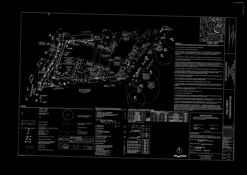
13 Source: Wells and Associates, Inc. LATR/PAMR Traffic Study. June 28, Note: Bethesda CBD Policy Area Congestion Standard: 1,800 CLV Policy Area Mobility Review (PAMR) - To satisfy the PAMR requirements of the APF test, a development located within the Bethesda CBD Policy Area is required to mitigate 25% of new peak-hour trips generated by the development. The proposed development will not result in any net new trips, and therefore is not subject to the PAMR requirements of the APF test. Other Public Facilities - Public facilities and services are available and will be adequate to serve the proposed development. The property will be served by public water and sewer connections that have been reviewed by WSSC. The application has been reviewed by the Montgomery County Fire and Rescue Service and they have determined that the property has appropriate access for fire and rescue vehicles. Electrical and telecommunications services are also available to serve the Property. Washington Suburban Sanitary Commission recommends approval of the plan finding that local lines exist, and they are of adequate size to serve the proposed development. Local health clinics, police stations and fire stations are all operating within acceptable levels as established by the Growth Policy. The site is located within the school service areas of the Bethesda Chevy Chase Cluster (B-CC) which includes Bethesda Elementary School, Westland Middle School, and Bethesda-Chevy Chase High School. The FY 2013 Subdivision Staging Policy school test finds that the elementary and middle school capacity to be adequate in the B-CC cluster. At the high school level a school facility payment is required for subdivision approval in FY The preliminary plan meets all applicable requirements for protection of environmentally sensitive areas. Natural Resource Inventory/Forest Stand Delineation (NRI/FSD) - A Natural Resources Inventory/Forest Stand Delineation (NRI/FSD) # was originally approved for the site on November 13, However the NRI/FSD ultimately expired in A new NRI/FSD # was approved for the site on October 10, The NRI/FSD identifies the property as 2.54 acres in size and shows that the site is not associated with any forest areas. The location is within an urban setting and aside from minor lawn panels and landscape beds the site is mostly covered by surface parking and the vacant post office building. However, the eastern boundary of the site is immediately adjacent to a substantial linear stand of trees within the Capital Crescent Trail Park property. Many of the trees located on the Parkland (between the trail itself and the subject property) are within a diameter size-class. A few significant trees up to 28 diameter also occur within this same area adjacent to the subject property. Larger specimen sized trees 30 diameter and greater (meeting the criteria of vegetation potentially subject to a variance) also occur within the Parkland but are located on the opposite side of the trail and are a considerable distance from the proposed development. The site is located within the Willett Branch subwatershed of the Little Falls Branch watershed; a Use I-P watershed. The property is not associated with special protection areas, erodible soils, steep slopes, wetlands, streams or associated buffers, and is therefore generally not subject to the environmental guidelines (excluding the overlap with the forest conservation review and also storm water Page 12
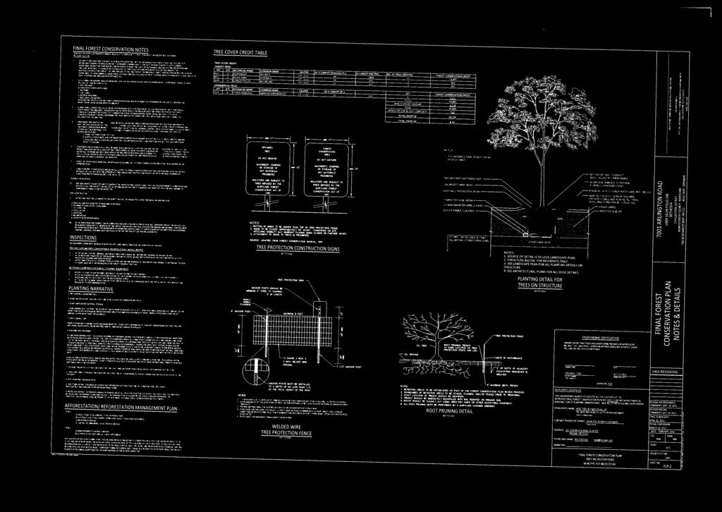
14 management/water quality concerns of which the Department of Permitting Services (DPS) is the lead agency). Final Forest Conservation Plan - The property is subject to the Chapter 22A Montgomery County Forest Conservation Law and a Final Forest Conservation Plan has been submitted for approval (stamped received on October 1, 2012). The proposed development which is located within a PD zone, triggers the special provision of forest conservation law section 22A-12(f)(2)(D) requiring that the afforestation requirements be met onsite. The net tract area for the forest conservation plan (which includes the subject property boundary and the offsite LOD) is 2.61 acres in size and does not include any forest. However, there is an afforestation requirement of 0.39 acres which will be met onsite by canopy credit for landscape plantings. The development plan amendment for this project was reviewed under zoning application no. G-861. The plan reviewed at that time was very similar to the plan proposed today, showing a garage footprint over the entire site. The approval of the previously reviewed plan included meeting the afforestation credits onsite via roof top plantings. To Staffs collective recollection and (the consultants as well), no other project to date has received credit for rooftop plantings. However, given the previous approval of the proposed layout and the fact that the forest conservation law requires that the afforestation credits are met onsite there was no reasonable alternative. The applicant has provided a number of case studies where rooftop tree plantings have been successfully implemented. Based on further research by Staff, a number of recommended conditions have been included (such as increased soil volume) to help ensure the forest conservation requirements are appropriately satisfied. The applicant has confirmed that additional soil volume recommended by Staff can be accommodated. Tree Save The site contains a number of minor trees which are proposed for removal. The street trees fronting the property on Arlington Road (which range from 7 to 17 diameter) are also proposed for removal. The tree removal within the road ROW will be coordinated with the Department of Transportation and/or the Maryland Department of Natural Resources as applicable. The trees within the Capital Crescent Trail Park property will potentially receive severe impacts due to the sediment control measures currently proposed. The site has a retaining wall that runs along most of its boundary with the adjacent parkland. The wall does provide an effective root barrier which would normally allow the work to occur one side of the wall and not cause any damage to trees on the opposite side. However the current proposal includes trenching for the installation of a sediment control fence behind the wall (immediately adjacent to the bases of numerous Park trees that are growing near the top of the wall). Staff has continuously expressed concerns for the trenching and requested that alternative sediment control practices be explored. The engineering consultant reported that the sediment control could not be installed on the work side of the wall due to conflict with shoring that would also be required and that a trenched device is needed behind the wall to satisfy DPS s concerns. Ultimately, Staff recommended that a modified detail to install sediment control at the top of the wall or the face of the wall be explored (subject to approval by DPS). The engineering consultant believed that such a detail could be approved but has not yet prepared the detail for DPS review and approval. Page 13
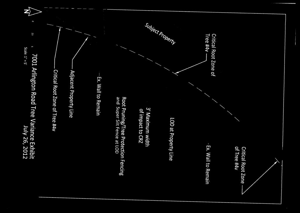
15 Parks staff does not support the trenching near the trees but does acknowledge that some removals and tree pruning would be required even if the trenching for sediment control is not performed. Parks has issued a number of conditions on how the tree work would be performed and is requesting a payment amount (to be determined) for each inch of tree diameter that is removed from the parkland to accommodate the proposed development. (The applicant had initially proposed replanting the disturbed Park areas however Parks preference is to utilize their expertise as well as their plant stock for the planting work on the parkland). Ultimately, if an alternative detail is not approved by DPS and traditional trenching for sediment control is required at the bases of the Park trees, than the tree removals within the parkland and associated replacement costs to the applicant will increase significantly. 4. The preliminary plan meets all applicable requirements of the county Forest Conservation Law. Forest Conservation Variance - Section 22A-12(b) (3) of Montgomery County Forest Conservation Law provides criteria that identify certain individual trees as high priority for retention and protection. Any impact to these trees, including removal of the subject tree or disturbance within the tree s critical root zone (CRZ), requires a variance. An applicant for a variance must provide certain written information in support of the required findings in accordance with Section 22A-21 of the County Forest Conservation Law. Unless the variance is granted, the law requires no impact to trees that measure 30 inches DBH or greater; are part of a historic site or designated with a historic structure; are designated as national, state, or county champion trees; are at least 75 percent of the diameter of the current State champion tree of that species; or to trees, shrubs, or plants that are designated as Federal or State rare, threatened, or endangered species. Since the project boundary affects one tree that is 30 DBH, a variance is required. The applicant submitted a variance request on July 31, 2012 for the impact to, but retention of one tree as a result of the proposed project (see Attachment B for variance request). Therefore one tree that is considered high priority for retention under Section 22A-12(b) (3) of the County Forest Conservation Law is proposed to be affected. The proposed project impacts less than 1% of the CRZ of the subject tree. No specialized tree preservation measures are needed in association with the impacts proposed to the subject tree, as outlined in the applicant s forest conservation variance request. Staff does not support the proposed use of root pruning within the fringe of the subject trees CRZ, not because of impact to the variance tree but due to the severe impacts which would be caused to other trees in the vicinity which are not subject to the variance. Section 22A-21 of the County Forest Conservation Law sets forth the findings that must be made by the Planning Board or Planning Director, as appropriate, in order for a variance to be granted. In addition to the required findings outlined numerically below, staff has determined that denial of the variance provision would result in an unwarranted hardship for the following reason: The site is surrounded by a retaining wall along portions of the property. The wall overlaps a minor portion of the CRZ of one subject tree. The wall itself is proposed to remain however must be included in the LOD to allow for stabilization of the wall, thereby protecting it from the deep excavation that will occur in close proximity to the wall. Not allowing that wall to be within the LOD would therefore be a hardship resulting in potential instability of the wall or a considerable reduction in the scope of the previously approved design concept. Page 14
16 Staff has reviewed this application and based on the existing circumstances and conditions on the property, staff agrees that there is an unwarranted hardship. Variance Findings - Staff has made the following determination based on the required findings that granting of the requested variance: 1. Will not confer on the applicant a special privilege that would be denied to other applicants. The minor impact to the subject trees CRZ is necessary to address stability of an existing retaining wall. Instability of the wall would result in further impacts /disturbance of the subject tree and surrounding properties in general. Therefore, the variance request would be granted to any applicant in a similar situation. 2. Is not based on conditions or circumstances which are the result of the actions by the applicant. The requested variance is based on proposed development allowed under the existing zoning and the proposed parking. In this case Staff has determined that impacts to the tree will be very minimal, where no mitigation is required. 3. Is not based on a condition relating to land or building use, either permitted or non-conforming, on a neighboring property. The requested variance is a result of the proposed site design and layout on the subject property and not as a result of land or building use on a neighboring property. 4. Will not violate State water quality standards or cause measurable degradation in water quality. The project will not violate State water quality standards or cause measurable degradation in water quality because the impacted tree is not proposed for removal. In accordance with Montgomery County Code Section 22A-21(c), the Planning Department is required to refer a copy of the variance request to the County Arborist in the Montgomery County Department of Environmental Protection for a recommendation prior to acting on the request. The applicants request was forwarded to the County Arborist on August 8, The County Arborist issued a response to the variance request on August 17, 2012 and recommended the variance be approved with the condition that mitigation is provided. (Attachment B). Additionally, the County Arborist provided general recommendations on calculating mitigation plantings and providing tree preservation measures. Generally, staff recommends that replacement plantings for variance purposes occur at a ratio of approximately 1 DBH for every 4 DBH removed, using onsite tree plantings that are a minimum of 3 caliper. However, staff generally does not recommend mitigation for trees impacted but retained. Since the subject tree can be appropriately retained, no mitigation planting is recommended. As a result of the above findings, staff recommends the Board approve the applicant s request for a variance from Forest Conservation Law to impact (but retain) one subject trees associated with the project (no removal of the subject tree is proposed). The variance approval is assumed into the Planning Page 15
17 Board s approval of the Forest Conservation Plan. Staff is recommending approval of Final Forest Conservation Plan with conditions listed in the recommendations and conditions section below. The variance approval is assumed into the Planning Board s approval of the Preliminary Forest Conservation Plan. Noise - The June 1983, Staff Guidelines for Consideration of Transportation Noise Impacts in Land Use Planning and Development states that 65 dba is generally applied in the urban ring, freeway and major highway corridor areas, where ambient levels are such that application of a stricter guideline would be infeasible or inequitable. MNCPPC transportation staff estimated that the average daily traffic (ADT) along south Arlington Road will be approximately 16,300 vehicles per day. Areas within 300 feet of an arterial road with an ADT of 5,000-20,000 vehicles may require attenuation. A noise analysis to identify and mitigate potential noise impacts is needed. Likely any affected units which may be identified can be attenuated from excessive noise by the design and appropriate installation of the building shell and windows. Some of the proposed outdoor space areas are potentially within noise impact zones. The building itself will deflect/absorb most of the noise that could potentially impact the outdoor passive recreation areas. A number of preliminary plan conditions are recommended by staff to ensure that noise levels are appropriately mitigated. 5. The stormwater management concept has been approved and is appropriate for the site. The proposed stormwater management concept approved on April 18, 2012, meets the required stormwater management goals by the use of environmentally sensitive design (ESD) measures to the maximum extent practicable. Treatment is provided by a combination of micro-biofilters and the use of volume based proprietary structural filter. The stormwater facilities on the site will be maintained by the developer. For routine inspections and maintenance, DEP will be allowed to access stormwater facilities on the terrace level via a vehicular lift provided by the applicant to remain on the property at all times. The Montgomery County Department of Permitting Services has accepted this form of access as has, DEP via s included in Attachment B. 6. The preliminary plan complies with Chapter 50, the Subdivision Regulations. The application has been reviewed for compliance with the Montgomery County Code, Chapter 50, the Subdivision Regulations. The preliminary plan reflects the general layout and road network that was reviewed by the Planning Board and the District Council as part of the Development Plan Amendment approved in January of this year. The proposed lot will have frontage on a public street. The size, width, shape and orientation of the lots are appropriate for the location of the subdivision. The proposed lot size is appropriate, for it accommodates a single building with a mix of uses. The width of the lot is suitable given the two points of access that are necessary to accommodate the required on-site loading and residential parking garage. The shape is appropriate, for the consolidation creates a more rectangular lot which is appropriate for the orientation of the property. Page 16
18 PRELIMINARY PLAN RECOMMENDATION AND CONDITIONS The Preliminary Plan meets all requirements established in the Subdivision Regulations and it is in substantial conformance with the recommendations of the Master Plan. Staff recommends approval of Preliminary Plan and associated final forest conservation plan, subject to the following conditions: 1. Total development is limited to a maximum of 140 residential dwelling units and 7,000 square feet of commercial uses. A minimum of 15% of the total number of dwelling units must be Moderately Priced Dwelling Units. 2. The Certified Final Forest Conservation Plan must include the following: a) Increase the soil depth over the entire rooftop planting beds so that a minimum soil depth of 3 will be provided. b) Provide appropriate details, exhibits and notes on the FFCP to clearly show the soil volumes/depth associated with plantings. Include provisions for irrigation and maintenance as applicable. c) Include a tree save plan component which addresses the foreseeable impacts to Park trees along the Capital Crescent Trail. The tree save plan shall also address the conditions enumerated by the Park arborist. d) Revised forest conservation data table. e) Clarification of the legend, notes and graphics to more clearly/accurately show the credited portions of planted tree canopy. 3. The sediment and erosion control plan and stormwater management plan must be submitted with the revised Final Forest Conservation Plan to ensure consistency with the Limits of Disturbances (LOD s) and the associated tree preservation measures. 4. Prior to approval of the certified site plan, the details for and location of noise mitigation techniques to attenuate current noise levels to no more than 65 dba Ldn for areas of common outdoor activity must be approved by staff. 5. Prior to approval of the certified site plan, the Applicant must submit a noise analysis prepared by an engineer specializing in acoustics that addresses details and locations of noise mitigation techniques to appropriately attenuate noise levels for the affected dwelling units. 6. The Applicant must provide M-NCPPC staff with a certification from an engineer specialized in acoustics that the building shell has been designed to attenuate projected exterior noise levels to an interior level not to exceed 45 dba Ldn prior to certified site plan. The builder commits to construct the units in accord with these design specifications, with any changes that may affect acoustical performance approved by the acoustical engineer in advance of installation. 7. After construction is complete, and prior to use and occupancy, the builder must provide M-NCPPC staff a certification from an engineer specialized in acoustics confirming that interior noise levels do not exceed 45 dba Ldn. 8. The Applicant must dedicate and show on the record plat(s) the following dedications: a) 80 feet from the opposite right-of-way line along the Subject Property frontage for Arlington Road. Page 17
19 9. The proposed traffic signal for the Arlington Road/Southern Site Access Driveway/Northern Bradley Boulevard Shopping Center intersection must be operational prior to the issuance of the residential Certificate of Use and Occupancy for the development. 10. The Planning Board has accepted the recommendations of the Montgomery County Department of Permitting Service ( MCDPS ) Water Resources Section in its stormwater management concept letter dated April 18, 2012, and does hereby incorporate them as conditions of the Preliminary Plan approval. Therefore, the Applicant must comply with each of the recommendations as set forth in the letter, which may be amended by MCDPS Water Resources Section provided that the amendments do not conflict with other conditions of the Preliminary Plan approval. 11. The Planning Board has accepted the recommendations of the Montgomery County Department of Transportation ( MCDOT ) in its letter dated September 25, 2012, and does hereby incorporate them as conditions of the Preliminary Plan approval. Therefore, the Applicant must comply with each of the recommendations as set forth in the letter (except for No. 17 as modified herein), which may be amended by MCDOT provided that the amendments do not conflict with other conditions of the Preliminary Plan approval. (17) Prior to submission of the TMAg, the Applicant must review potential locations on the application site for a bike sharing docking station (or similar provision required by the bike sharing system) to enable this form of transportation to be used by residents, employees and visitors at the Project. If the Applicant elects to provide a bike sharing docking station on the application site, the location of this docking station will be selected by the Applicant with approval of the TMD, based upon the requirements of the bike sharing system and in a highly-visible, convenient, and well-lit location on the Project. If zoning regulations or other provisions adopted prior to issuance of the building so provide, the Project shall be required to pay the capital cost of such station and five years of operating expenses in return for offsetting parking reductions or other benefits. 12. The Applicant must enter into a Traffic Mitigation Agreement ( TMAg ) with the Planning Board and DOT to participate in the Bethesda Transportation Management District (TMD) and must execute the TMAg prior to the release of any residential building permit for development on the site. The TMAg must include those trip mitigation measures recommended by MCDOT, except as modified herein. 13. Prior to recordation of plat(s), the Applicant must satisfy the provisions for access and improvements as required by MCDOT. 14. Prior to recordation of any plat, Site Plan No must be certified by MNCPPC Staff. 15. The record plat must show necessary easements. 16. Final approval of the number and location of buildings, on-site parking, site circulation, and sidewalks will be determined at site plan. 17. No clearing, grading or recording of plats prior to certified site plan approval. 18. The certified Preliminary Plan must contain the following note: Unless specifically noted on this plan drawing or in the Planning Board conditions of approval, the building footprints, building heights, on-site parking, site circulation, and sidewalks shown on the Preliminary Plan are illustrative. The final locations of buildings, structures and hardscape will be determined at the time of site plan approval. Please refer to the zoning data table for development standards such as setbacks, building restriction lines, building height, and lot coverage for each lot. Page 18
20 Other limitations for site development may also be included in the conditions of the Planning Board s approval. 19. The Adequate Public Facility (APF) review for the Preliminary Plan will remain valid for eighty-five (85) months from the date of mailing of the Planning Board Resolution. SECTION 3: SITE PLAN REVIEW FINDINGS 1. The site plan conforms to all non-illustrative elements of a development plan or diagrammatic plan, and all binding elements of a schematic development plan, certified by the Hearing Examiner under Section 59-D-1.64, or is consistent with an approved project plan for the optional method of development, if required, unless the Planning Board expressly modifies any element of the project plan. The site plan conforms to all non-illustrative elements and binding elements of DPA 11-4 approved by the County Council on January 24, 2012, with the Resolution No [Appendix A]. The binding elements, as set forth below, limited the density of this site and established parameters for unit affordability, screening, unit type, and lot use/lot size. 1) The building will have a maximum height of 59.9, as measured from the building height measuring point in the centerline of Arlington Road, whose elevation is , as shown on the development plan. The maximum height proposed in the site plan is 59.9 feet. 2) The development will have a maximum density of 1.66 FAR. The applicant proposes to develop the site at a density of 1.42 FAR. 3) The maximum number of multi-family dwelling units to be contained in the building shall not exceed 145. A maximum of 140 dwelling units is proposed for approval on the site plan. 4) The building shall include 15.2% moderately priced dwelling units (if 145 units are approved for construction). Since a maximum of 140 units are proposed for construction, the applicant is providing 15% of the units (or 21 units) as MPDUs. 5) The development will provide a minimum of 50% green area on the site. A minimum 50.8% green area is provided as part of the proposed development in the site plan. Page 19
21 6) As part of the site plan process for the 7001 Arlington Road project, the signalization proposed in the development plan must be approved by DPWT, including lane geometry and the provision of necessary rights of way or easement assurances on the west side of Arlington Road. Prior to application for the building permit for construction of the building the final design for the signal must be approved, prior to issuance of the building permit the signal must be permitted and bonded, and prior to the issuance of occupancy permits the signal must be operational. MCDOT has approved the signalization concept plan for the intersection of Arlington Road and the new driveway to the parking garage per their letter dated September 25, ) The residential building walls, exclusive of roof overhangs, cornices, balconies, patios, terraces, underground parking garages, garage stair access ways, and similar appurtenances, will have a minimum 60 foot setback from the eastern property line. The applicant proposes to exceed the required 60 foot setback from the Capital Crescent Trail by providing a 67.3 foot setback. 8) Access from the subject site to the Capital Crescent Trail will be provided for residents of the project via walkways from the building to the Capital Crescent Trail access point. As shown on the site plan, the applicant is providing a walkway from the building to the Capital Crescent Trail. 9) Any fencing along the eastern property line will not be solid in order to allow views from the Capital Crescent Trail to the subject site. Screening the rear of the proposed lot with is currently proposed via construction of a 60- inch high fence with a metal picket design that will not be solid to allow for views. 2. The Site Plan meets all of the requirements of the zone in which it is located, and where applicable conforms to an urban renewal plan approved under Chapter 56. The Site Plan meets all of the requirements of the Planned Development (PD) Zone and satisfies the design, housing, amenity, circulation, and other purposes of the PD Zone. The project will provide a range of dwelling types consistent with the purpose of the zone. The development provides for a unified form of development at an overall density and mixture of unit types that is generally consistent with the recommendations in the Bethesda CBD Sector Plan. The proposed development also includes measures that are designed to enhance natural stormwater filtration and recharge. The design and layout of the proposed development provides appropriate vehicular linkages, provides for the safety, convenience and amenity of residents, and assures compatibility with the surrounding land uses. The site is zoned PD-44 consistent with DPA 11-4 approved by the County Council and specifically recommended in the Bethesda CBD Sector Plan. The PD-44 Zone allows the Page 20
22 proposed retail and residential uses. The density allowed in the PD-44 Zone is 44 dwelling units per acre, which is equivalent to a maximum base density of 118 units on the entire site. However, consistent with the Subsection 59-C-7.14(c) of the Zoning Ordinance, the applicant is entitled to a bonus density of 22% because it will provide 15% MPDUs onsite. As a result, the maximum density for the site is 145 dwelling units, which is consistent with the maximum allowed per the binding elements, however this project proposes a maximum of 140 dwellings units. As demonstrated in the Data Table below, the project meets all of the applicable requirements of the PD-44 Zone. Development Standard Data Table for the PD-44, Optional Method of Development Zoning Ordinance Permitted/ Required Binding Elements per DPA 11-4 Proposed for Approval & Binding on the Applicant Gross Tract Area (GTA) n/a n/a 117,725 sf Density Residential FAR Max. Residential Density (du/acres) 59-C-7.14(a) 1.66 FAR n/a 44 du/ac (if 12.5% MPDUs provided) du/ac (if 15% MPDUs provided) 1 MPDUs (%) 12.5% minimum 15.2% (if 145 units are approved) Max. Number of Dwelling Units 145 (including 22% - Market Rate density bonus for - MPDUs 15% MPDUs) Housing Mix (59-C-7.13) Min. one-family detached Min. one-family attached/townhouses Multi-family Min. Setbacks Main Building (ft) Adjoining one-family detached zoned land (59-C-7.15) Permitted, but not required Permitted, but not required 50% 2 100% 145 maximum 140 (119) (21) 1.42 FAR du/ac (including 22% density bonus) 15% (if 140 units are approved) 100% n/a 60 ft 67.3 ft From public street n/a n/a 0 Front yard n/a n/a 0 Rear yard (opposite front door) n/a n/a 67.3 Page 21
23 Side yard n/a n/a 0 Max. Building Height (feet) n/a 59.9 feet 59.9 feet Min. Green Area (% of GTA) (59-C-7.16) 50% 50% 50.8% (59,802 sf) Land Dedicated to Public Use (59-C-7.17) (acres) n/a n/a 4,176 sf - MCDOT Public Roads Parking Spaces (59-E) 3 Residential Retail n/a Per Sec. 59-C-7.14(c), the maximum density may be increased to accommodate the construction of MPDUs and workforce housing units.. 2 Per Sec. 59-C-7.131, if the minimum percentage would yield a total of 150 multiple-family dwelling units or less, this requirement does not apply and no such units are required. 3 The site is located within the Parking Lot District and, therefore, the applicant is not required to provide on-site parking in accordance with the Zoning Ordinance standards. For this application, the applicant has elected to provide all parking on-site. 1. The locations of buildings and structures, open spaces, landscaping, recreation facilities, and pedestrian and vehicular circulation systems are adequate, safe, and efficient. a) Locations of buildings and structures Page 22

24 Garage Level Floor Plan The locations of the proposed mixed use building and parking garage structure are adequate, safe, and efficient. The plan proposes 7,000 square feet of retail uses and 140 multifamily dwelling units. The location of the retail is appropriately oriented to the street and the dwelling units are adequately oriented towards the Capital Crescent Trail with a substantial setback and appropriately placed above the street oriented retail space. The general Z-shape of the building creates two landscaped courtyard areas for residents of the building and helps provide a buffer between the units and the parking garages located to the north and south of the site. The parking garage will be built to the rear property line with access located off of Arlington Road along the south side of the building and setback from the street to avoid pedestrian conflicts. Along the north side of the building a second driveway is proposed for loading activities. A loading area in this location will reduce impacts to vehicular traffic flow in the garage and the residential building entrance. b) Open Spaces The open spaces provided are adequate, safe, and efficient. The PD zone does not have an open space requirement; instead it has a minimum green area requirement of 50 percent of the gross tract area for PD-44. The site plan depicts a green area satisfying this requirement consisting of the second-story terrace, the streetscape and sidewalk proposed along Arlington Road, and the buffer area along the Capital Crescent Trail. Page 23

25 Illustrative rendering of the open spaces and amenity areas c) Landscaping and Lighting The landscape plan which places an emphasis on native species is adequate, safe, and efficient. The landscape plan achieves several objectives. It meets the PD-44 zone forest conservation requirements for an optional method project. It also provides an adequate buffer and screening from the Capital Crescent Trail and adjacent one-family detached community to the east of the proposed development. Additionally, the landscaping provides canopy coverage and shade for the picnic areas, the edge of the open play area, and the streetscape in front of the building. A variety of plant materials are incorporated into the landscape plan to add interest and delineate the various spaces, including ornamental trees, herbaceous plants, and deciduous shrubs. The streetscape will be constructed in accordance with the Bethesda streetscape standards using the Zelkova tree species. As proposed, the lighting consists of four pole mounted light fixtures along the Arlington Road street frontage with a maximum height of 16 feet. Onsite, the applicant proposes 3 deck site lights and 11 deck pole lights. The deck lights extend approximately one foot off the ground and the deck pole light height was not specified by the applicant. Therefore, staff recommends that these pole lights be no greater than 12 feet in height (as measured above grade), which is more residential in character and reduces visibility from adjacent properties and thus increases compatibility with the neighborhood. The lighting proposed will create enough visibility to provide safety but not so much as to cause glare on adjacent properties. As conditioned, the lighting recommended by Staff is adequate, safe and efficient. Page 24
26 Landscape Plan d) Recreation Facilities The recreation facilities are safe, adequate, and efficient. The recreation facilities provided include four picnic/sitting areas, an open play area (level II), horseshoes, a pedestrian system, indoor community space, and an indoor fitness facility. As demonstrated in the tables below, this development meets all the recreation requirements on-site through these facilities, which satisfy the 1992 M-NCPPC Recreation Guidelines. The facilities adequately and efficiently meet the recreation requirements of this development, while providing safe and accessible recreation opportunities for residents of all ages in the development. Furthermore, the site s close proximity to the Capital Crescent Trail will provide additional opportunities for recreation. Demand D1 D2 D3 D4 D5 Number Tots Children Teens Adults Seniors Housing Type of Units 0 to 4 5 to to to HIGH RISE On-Site Supply D1 D2 D3 D4 D5 Quantity Tots Children Teens Adults Seniors Recreation Facility Provided 0 to 4 5 to to to Picnic/Sitting Open Play Area II Horseshoes Pedestrian System Indoor Community Space Page 25
27 Indoor Fitness Facility total: Adequacy of Facilities D1 D2 D3 D4 D5 a. Gross Total Supply b. 35% of Total Supply c. Max Off-Site Supply d. Total Supply e. 90% Demand f. Adequate? yes yes yes yes yes e) Pedestrian and Vehicular Circulation Systems The pedestrian and vehicular circulation systems are safe, adequate, and efficient. Access to the site will be from Arlington Road at two locations; one using the existing curb cut on the north side of the property for loading operations and the other a new driveway on the south side of the site. The newly constructed access point will accommodate traffic entering the garage for residential parking as well as retail parking. This access point will be aligned with the Bradley Shopping Center Driveway on the west side of Arlington Road and will require a signal at Arlington Road to accommodate traffic in this location. With the signal, the vehicular circulation efficiently directs traffic into and through the site with minimal impacts to pedestrian circulation in the area. The project exceeds the parking requirement of 190 spaces by providing 211 spaces. The applicant believes this number of parking spaces is necessary to adequately serve the uses on the site. While staff believes the minimum requirement should suffice, the applicant has elected to provide 211 spaces so that all uses in the building can be accommodated with a small amount of surplus parking. The applicant has provided autoturn studies to ensure that all necessary vehicular movements can be made in the garage as shown on the site plan. The pedestrian circulation system adequately and efficiently integrates this site into the surrounding area. The streetscape along the property frontage ranges from 23 to 28 feet with a minimum of 6 feet clear sidewalk for pedestrians. From Arlington Road, pedestrian connections for future residents are provided via a 10 foot wide sidewalk area located along the southern façade of the building where there is a residential lobby and from Arlington Road on the northern side of the building there is a narrower 4 to 5 foot wide sidewalk connecting to a secondary entrance. An additional connection along the eastern façade of the building is provided to give residents of the building access to the Capital Crescent Trail which facilitates excellent access to the surrounding area. The Site Plan efficiently accommodates pedestrians entering and leaving the site. Page 26


 North")
28 East building elevation (view from Capital Crescent Trail) West building elevation (view from Arlington Road) South building elevation (one façade shown-residential lobby entrance) North building elevation (one façade shown) Page 27
29 4. Each structure and use is compatible with other uses and other site plans and with existing and proposed adjacent development. The proposed development will be compatible with the surrounding area. The combination of multifamily residential and retail is recommended in the Sector Plan for this site. Further, as noted in the Plan, multifamily residential at this location will provide a proper transition between the onefamily residential homes of the Sacks neighborhood and the surrounding commercial uses along Arlington Road. The location of the retail space is suitable because it will still serve as a buffer because all commercial activity on site will be consolidated on Arlington Road, the furthest portion of the site from the Sacks neighborhood. Only the residential activity should be visible from the Sacks neighborhood. The visual appearance of the subject site will be greatly improved. The density and resulting activity levels will be compatible with the mix of urban land uses in the surrounding area. The site design will also make the building and density compatible with the trail and nearby homes. With a 67.5-foot setback for the residential stories, the proposed building will be a compatible addition to this section of the Trail. The site design will provide sunlight between two large, existing structures that sit on opposite sides of the subject property adjoining the trail and will provide a green buffer with space for extensive plantings. The building height will be similar to adjacent and nearby buildings, and the rear setback will prevent the building from looming over trail uses. With the proposed traffic light, the proposed development will not be incompatible due to adverse traffic impacts, but rather will bring improvements to traffic flow along Arlington Road near the subject property. As discussed above, the proposed development will be compatible with existing development in the surrounding area. The specific setback and building height provisions are discussed below. Section 59-C-7.15(b) reads as follows: (b) In order to assist in accomplishing compatibility for sites that are not within, or in close proximity to a central business district or transit station development area, the following requirements apply where a planned development zone adjoins land for which the area master plan recommends a one-family detached zone: (1) No building other than a one-family detached residence can be constructed within 100 feet of such adjoining land; and (2) No building can be constructed to a height greater than its distance from such adjoining land. Section 59-C-7.15(b) does not apply to the subject site because by its terms, it is intended to assist in accomplishing compatibility for sites that are not within, or in close proximity to a central business district (emphasis added). The subject property is in close proximity to the Bethesda CBD, as it sits within 600 feet of the CBD boundary. The language of Section 59-C-7.15(b) applies to all potential Page 28
30 applications of the PD Zone anywhere in the County. Viewed in the context of the County as a whole, a site that is a few hundred feet from a CBD can readily be considered in close proximity. This language is intended to distinguish areas that are close to a CBD, where residents should expect commercial uses nearby, from areas with no CBD in sight, where residents may expect a higher degree of privacy and quietness in a residential setting. Accordingly, Section 59-C-7.15(b) does not apply to the subject site. 5. The Site Plan meets all applicable requirements of Chapter 22A regarding forest conservation, Chapter 19 regarding water resource protection, and any other applicable law. This site is subject to the County Forest Conservation Law. An NRI/FSD # was approved for the site on October 10, 2011, and a Final Forest Conservation Plan has been submitted for approval (stamped received on October 1, 2012). The variance request to impact one tree that is 30 DBH was recommended for approval by the County Arborist. The proposed storm water management concept approved on April 18, 2012, meets the required stormwater management goals by the use of environmentally sensitive design (ESD) measures to the maximum extent practicable. Treatment is provided by a combination of micro-biofilters and the use of volume based proprietary structural filter. The Site Plan meets all applicable requirements of Chapter 22A regarding forest conservation with the conditions of approval, and Chapter 19 regarding water resource protection. Page 29
31 SITE PLAN RECOMMENDATION AND CONDITIONS Staff recommends approval of site plan and the associated final forest conservation plan, 7001 Arlington Road, for 140 multi-family dwelling units including 15% MPDUS on 2.70 acres. All site development elements shown on the site and landscape plans stamped Received by the M-NCPPC on July 30, 2012 are required except as modified by the following conditions. Conformance with Previous Approvals 1. Development Plan Conformance The proposed development must comply with the binding elements of the development plan amendment Preliminary Plan Conformance The proposed development must comply with the conditions of approval for Preliminary Plan No , or as amended. Environment 3. Stormwater Management The proposed development is subject to Stormwater Management Concept approval conditions dated April 18, 2012 unless amended and approved by the Montgomery County Department of Permitting Services. Parks, Open Space, and Recreation 4. Recreation Facilities a) Meet the square footage requirements for all of the applicable proposed recreational elements and demonstrate on the certified site plan that each element is in conformance with the approved M-NCPPC Recreation Guidelines. b) Provide the following recreation facilities: four picnic/sitting areas, an open play area II, horseshoes, a pedestrian system, indoor community space, and an indoor fitness facility. 5. Parks a) The Applicant is not permitted to use the Capital Crescent Trail to access its property for regular inspection and/or maintenance of stormwater or other facilities located on the Applicant s property. b) A Park Construction Permit is required prior to commencement of any construction activity on M-NCPPC property. c) The Applicant must construct all improvements related to the project including any utilities, retaining walls, fences, or footings, entirely on the Applicant s Property unless permission is granted to locate them on M-NCPPC property by the Park Construction Permit. d) The access path from the site to the Capital Crescent Trail must enter the Trail at or near the Memorial Plaza area. The access path must be 3 feet wide or as specified in the Park Construction Permit. The exact location, design and specifications for construction of the access trail must be in keeping with the Capital Crescent Trail experience and setting, and must be reviewed and approved by M-NCPPC Parks Department staff. Any portion of the Page 30
32 access trail on park property must be constructed to park standards and specifications unless otherwise specified in the Park Construction Permit. The fence and gate construction proposed by the Applicant must be reviewed and approved by M-NCPPC Department of Parks staff. e) The Applicant and any future assignees shall be responsible for all improvements associated with the park permit including but not limited to maintenance, repair, and replacement of any facilities located on parkland, including the access trail and any other features allowed by the park permit. f) An M-NCPPC Parks Department Senior Urban Forester must be contacted to attend the preconstruction meeting. g) At the pre-construction meeting, tree removals and/or tree limb pruning must be identified based on determination by M-NCPPC Parks Department Senior Urban Forester that trees or limbs are dead, have an excessive lean or are close enough to the property line to be impacted by the trenching. h) If tree removals are determined necessary at the pre-construction meeting, M-NCPPC Parks Department will require an inch for inch replacement fee based on tree diameter. Tree replacement must be met by Fee in Lieu at a dollar amount per inch caliper to be determined by the M-NCPPC Parks Department Urban Forester. i) Trees identified as removals by M-NCPPC Parks Department Senior Urban Forester must be removed by the applicant at no cost to the Parks Department. j) The Applicant must hire a certified arborist and Maryland Licensed Tree Expert to do the removals and pruning as well as root pruning. k) Tree removals must be executed from the Applicant s property only if equipment is used (i.e. aerial lift) or by climbers on foot with saws if working from the Park Property under the direction of M-NCPPC Parks Department Senior Urban Forester. l) The Applicant must remove all wood and debris from disturbed areas and stumps must be cut as flush to grade as feasible. m) A plan must be in place to keep users of the trail out of harm's way during the tree removal operations such as flaggers, signs, etc as closing the trail is not always an option. n) Where there is not an existing retaining wall, all root pruning must be executed on the Applicant's property and must take place under the direction of M-NCPPC Parks Department Senior Urban Forester. o) Tree protection fencing must be 4 foot welded wire at a minimum and must run the length of park property. p) Where there is an existing retaining wall, per DPS approval, sediment control will be placed on top of the wall and root pruning will not take place. q) Armored Trunk protection must be in place within 5 feet of the limits of disturbance. Density & Housing 6. Moderately Priced Dwelling Units (MPDUs) r) The development must provide 15 percent of the total number of units as MPDUs on-site, consistent with the requirements of Chapter 25A. s) The MPDU agreement to build must be executed prior to the release of any residential building permits. t) All of the required MPDUs shall be provided on-site. Page 31
33 Site Plan 7. Landscaping All green area between the top of the parking deck and the outdoor space must contain a minimum of 3 feet of soil depth to accommodate landscaping and for credit toward the trees counted toward the afforestation requirement 8. Lighting a) The lighting distribution and photometric plan with summary report and tabulations must conform to IESNA standards for residential development. b) All on-site down- light fixtures must be full cut-off fixtures. c) Deflectors shall be installed on all fixtures causing potential glare or excess illumination, specifically on any perimeter fixtures located on the terrace level abutting adjacent properties. d) Illumination levels shall not exceed 0.5 footcandles (fc) at any property line abutting county roads and residential properties. e) The height of on-site light poles above grade shall not exceed 12 feet including the mounting base. 9. Landscape Surety Provide a performance bond in accordance with Section 59-D-3.5(d) of the Montgomery County Zoning Ordinance with the following provisions: a) The amount of the surety shall include plant material, on-site lighting, recreational facilities, and site furniture within the relevant phase of development. Surety to be posted prior to issuance of first building permit. b) Provide a cost estimate of the materials and facilities, which, upon staff approval, will establish the initial bond amount. c) Completion of plantings to be followed by inspection and bond reduction. Inspection approval starts the 1 year maintenance period and bond release occurs at the expiration of the one year maintenance period. d) Provide a Site Plan Surety & Maintenance Agreement that outlines the responsibilities of the Applicant and incorporates the cost estimate. Agreement to be executed prior to issuance of the first building permit. 10. Development Program The Applicant must construct the proposed development in accordance with a development program that will be reviewed and approved prior to the approval of the Certified Site Plan. The development program must include the following items in its phasing schedule: a) Street lamps and sidewalks must be installed within six months after street construction is completed. Street tree planting may wait until the next growing season. b) On-site amenities including, but not limited to, sidewalks, benches, trash receptacles, and bicycle facilities must be installed prior to release of the final building occupancy permit. c) Clearing and grading must correspond to the construction phasing to minimize soil erosion and must not occur prior to certification of the Final Forest Conservation Plan, Sediment Control Plan, and M-NCPPC inspection and approval of all tree-save areas and protection devices. d) The development program must provide phasing for installation of on-site landscaping and Page 32
34 lighting. e) Community-wide pedestrian pathways, including the path connection and gate from the private courtyard to the Capital Crescent Trail must be completed prior to issuance of the final building occupancy permit. f) Recreation facilities within the building and in the courtyard area must be completed prior to issuance of the final building occupancy permit. g) Landscaping associated with the courtyard and building shall be completed prior to issuance of the final building occupancy permit. h) Pedestrian pathways and seating areas associated with each facility must be completed as construction of each facility is completed. i) The proposed traffic signal for the Arlington Road/Southern Site Access Driveway/Northern Bradley Boulevard Shopping Center intersection must be operational prior to the issuance of the residential Certificate of Use and Occupancy for the development. j) Provide each section of the development with necessary roads. k) The development program must provide phasing of dedications, stormwater management, sediment and erosion control, afforestation, trip mitigation, and other features. 11. Clearing and Grading Clearing and grading must correspond with construction activities to minimize soil erosion and must not occur prior to certification of the Final Forest Conservation Plan, approval of Sediment Control Plan, and M-NCPPC inspection and approval of all tree-save areas and protection devices. 12. Certified Site Plan Prior to approval of the Certified Site Plan the following revisions must be made and information provided subject to Staff review and approval: a) Include the certified forest conservation plan, stormwater management concept approval memorandum, development program, inspection schedule, and site plan resolution on the cover sheet. b) Add a note to the site plan stating that M-NCPPC staff must inspect all tree-save areas and protection devices prior to clearing and grading. c) Clearly indicate the type of fence to be constructed along the eastern property line that abuts the Capital Crescent Trail. Any fence must not be solid in accordance with the applicable binding element. d) Ensure consistency off all details and layout between site plan and landscape plan. APPENDICES A. Resolution (DPA 11-4) B. Applicant s Tree Variance Request and County Arborist Response Letter C. M-NCPPC interoffice memorandums D. Reviewing Agency approvals and correspondence E. Applicant s response to MCDOT September 25, 2012 memorandum F. Applicant s request for certain permit allowances Page 33
35
36
37
38
39
40
41
42
43
44
45
46
47
48
49
50
51
52
53
54
55
56
57
58
59
60
61
62
63
64
65
66
67
68
69
70
71
72
73
74

75

76

77
78

79
MONTGOMERY COUNTY PLANNING DEPARTMENT THE MARYLAND-NATIONAL CAPITAL PARK AND PLANNING COMMISSION
 MONTGOMERY COUNTY PLANNING DEPARTMENT THE MARYLAND-NATIONAL CAPITAL PARK AND PLANNING COMMISSION MCPB Item No. 4 7/18/13 4990 Fairmont Avenue, Project Plan 920130070 & Preliminary Plan 120130230 Erin Grayson,
MONTGOMERY COUNTY PLANNING DEPARTMENT THE MARYLAND-NATIONAL CAPITAL PARK AND PLANNING COMMISSION
 MONTGOMERY COUNTY PLANNING DEPARTMENT THE MARYLAND-NATIONAL CAPITAL PARK AND PLANNING COMMISSION MCPB Item No. Date: 12-10-15 Leisure World Clubhouse II Addition Fitness Center, Limited Site Plan Amendment
MONTGOMERY COUNTY PLANNING DEPARTMENT THE MARYLAND-NATIONAL CAPITAL PARK AND PLANNING COMMISSION
 MONTGOMERY COUNTY PLANNING DEPARTMENT THE MARYLAND-NATIONAL CAPITAL PARK AND PLANNING COMMISSION MCPB Item No. Date: 3.10.2016 Site Plan 820160040 Nora School Parker Smith, Planning Technician, Area 1,
The subject site plan amendment proposes the following revisions to the approved site plan:
 PROPOSED AMENDMENT The subject site plan amendment proposes the following revisions to the approved site plan: 1. The building footprint was modified to accommodate the revised architectural design. 2.
MONTGOMERY COUNTY PLANNING DEPARTMENT THE MARYLAND-NATIONAL CAPITAL PARK AND PLANNING COMMISSION
 MONTGOMERY COUNTY PLANNING DEPARTMENT THE MARYLAND-NATIONAL CAPITAL PARK AND PLANNING COMMISSION MCPB Item No. 3 4/3/14 4990 Fairmont Avenue, Site Plan 820140060 Erin Banks, AICP, Senior Planner, Area
MONTGOMERY COUNTY PLANNING DEPARTMENT
 MONTGOMERY COUNTY PLANNING DEPARTMENT THE MARYLAND-NATIONAL CAPITAL PARK AND PLANNING COMMISSION MCPB Item No.: Date: 5-03-18 Pike and Rose, Phase I: Site Plan Amendment No. 82012002D Rhoda Hersson-Ringskog,
MONTGOMERY COUNTY PLANNING DEPARTMENT THE MARYLAND-NATIONAL CAPITAL PARK AND PLANNING COMMISSION
 MONTGOMERY COUNTY PLANNING DEPARTMENT THE MARYLAND-NATIONAL CAPITAL PARK AND PLANNING COMMISSION MCPB Item No. Date: 06-12-14 King of the Nations Christian Fellowship Church: Limited Site Plan Amendment
MONTGOMERY COUNTY PLANNING DEPARTMENT THE MARYLAND-NATIONAL CAPITAL PARK AND PLANNING COMMISSION
 MONTGOMERY COUNTY PLANNING DEPARTMENT THE MARYLAND-NATIONAL CAPITAL PARK AND PLANNING COMMISSION MCPB Item No.: 2 Date: 12-19-13 Site Plan 820140020, 8001 Newell Street Neil Braunstein, AICP, Area 1, neil.braunstein@montgomeryplanning.org,
MONTGOMERY COUNTY PLANNING DEPARTMENT THE MARYLAND-NATIONAL CAPITAL PARK AND PLANNING COMMISSION
 MONTGOMERY COUNTY PLANNING DEPARTMENT THE MARYLAND-NATIONAL CAPITAL PARK AND PLANNING COMMISSION MCPB Item No. 6 Date: 5-9-13 Site Plan No. 820130090, West Chevy Chase Heights Erin Grayson, Senior Planner,
MONTGOMERY COUNTY PLANNING DEPARTMENT THE MARYLAND-NATIONAL CAPITAL PARK AND PLANNING COMMISSION
 MONTGOMERY COUNTY PLANNING DEPARTMENT THE MARYLAND-NATIONAL CAPITAL PARK AND PLANNING COMMISSION 8015 Old Georgetown Road, Preliminary Plan 120160220, Site Plan 820160090 MCPB Item No.: 8 Date: 11-03-16
MONTGOMERY COUNTY PLANNING DEPARTMENT THE MARYLAND-NATIONAL CAPITAL PARK AND PLANNING COMMISSION
 MONTGOMERY COUNTY PLANNING DEPARTMENT THE MARYLAND-NATIONAL CAPITAL PARK AND PLANNING COMMISSION MCPB Item No. Date: 1/26/12 Hanover Shady Grove, Sketch Plan 320120020 Joshua Sloan, Coordinator, Joshua.Sloan@MontgomeryPlanning.org,
MONTGOMERY COUNTY PLANNING DEPARTMENT
 MONTGOMERY COUNTY PLANNING DEPARTMENT THE MARYLAND-NATIONAL CAPITAL PARK AND PLANNING COMMISSION MCPB Item No. Date: 12/20/2018 Nucci Subdivision, Preliminary Plan No. 120160170 MF Marco Fuster, Planner
MONTGOMERY COUNTY PLANNING DEPARTMENT THE MARYLAND-NATIONAL CAPITAL PARK AND PLANNING COMMISSION
 MONTGOMERY COUNTY PLANNING DEPARTMENT THE MARYLAND-NATIONAL CAPITAL PARK AND PLANNING COMMISSION MCPB Item No. 3 Date: 02-28-13 8415 Fenton Street, Preliminary Plan 120120130, Site Plan 820130050 John
12 January 12, 2011 Public Hearing APPLICANT: TAILWIND DEVELOPMENT GROUP,LLC PROPERTY OWNER: CITY OF VIRGINIA BEACH
 12 January 12, 2011 Public Hearing APPLICANT: TAILWIND DEVELOPMENT GROUP,LLC PROPERTY OWNER: CITY OF VIRGINIA BEACH STAFF PLANNER: Faith Christie REQUEST: Conditional Change of Zoning (from PD-H1 Planned
MONTGOMERY COUNTY PLANNING DEPARTMENT THE MARYLAND-NATIONAL CAPITAL PARK AND PLANNING COMMISSION
 MONTGOMERY COUNTY PLANNING DEPARTMENT THE MARYLAND-NATIONAL CAPITAL PARK AND PLANNING COMMISSION The Goddard School in North Bethesda Preliminary Plan Amendment 11996015B and Site Plan Amendment 82006005A
I. Introduction. Prior Approvals
 Statement of Justification First National Bank 19790 Crystal Rock Drive, Germantown, Maryland Application for Site Plan and Limited Preliminary Plan Amendment I. Introduction DPH Architecture, for First
MONTGOMERY COUNTY PLANNING DEPARTMENT THE MARYLAND-NATIONAL CAPITAL PARK AND PLANNING COMMISSION
 MONTGOMERY COUNTY PLANNING DEPARTMENT THE MARYLAND-NATIONAL CAPITAL PARK AND PLANNING COMMISSION MCPB Item No. Date: 1/15/2015 Bethesda North Marriott Hotel and Conference Center: Limited Site Plan Amendment
MONTGOMERY COUNTY PLANNING DEPARTMENT Newell Street. Site Plan Item #2. Maryland-National Capital Park and Planning Commission
 8001 Newell Street Site Plan 820140020 Item #2 December 19, 2013 Redlined Conditions 1. The Applicant must comply with the conditions of approval for Project Plan 920130020 in MCPB Resolution No. 13-74.
MONTGOMERY COUNTY PLANNING DEPARTMENT THE MARYLAND NATIONAL CAPITAL PARK AND PLANNING COMMISSION
 MONTGOMERY COUNTY PLANNING DEPARTMENT THE MARYLAND NATIONAL CAPITAL PARK AND PLANNING COMMISSION MCPB Item No. 8 Date: 3.30.2017 Project Name: Lot 31/31A Bethesda, Site Plan Amendment, No. 82007018C Elza
Clarksburg Square Road Extension
 Clarksburg Square Road Extension Preliminary Plan No. 120140060 Site Plan No. 820140050 Site Plan Amendment No. 82007022C (Clarksburg Town Center) Clarksburg SPA Water Quality Plan Mandatory Referral MR2015008
MONTGOMERY COUNTY PLANNING DEPARTMENT THE MARYLAND NATIONAL CAPITAL PARK AND PLANNING COMMISSION
 MONTGOMERY COUNTY PLANNING DEPARTMENT THE MARYLAND NATIONAL CAPITAL PARK AND PLANNING COMMISSION MCPB Item No. Date: 5.3.18 8000 Wisconsin Avenue Sketch Plan No. 320180120 Matthew Folden, Planner Coordinator,
MONTGOMERY COUNTY PLANNING DEPARTMENT THE MARYLAND NATIONAL CAPITAL PARK AND PLANNING COMMISSION
 MONTGOMERY COUNTY PLANNING DEPARTMENT THE MARYLAND NATIONAL CAPITAL PARK AND PLANNING COMMISSION MCPB Item No. 3 Date: 1.5.17 7272 Wisconsin Avenue: Sketch Plan Amendment No. 32016004A, Preliminary Plan
Westwood Shopping Center Sketch Plan, Plan # February 23, 2017 Item # 9
 Westwood Shopping Center Sketch Plan, Plan # 320170010 February 23, 2017 Item # 9 Westwood II Site 64,111 s.f. Manor Care site: vacant two story building HOC-Westwood Towers, 15 story tower To be considered
14 October 10, 2012 Public Hearing APPLICANT: MPB, INC
 14 October 10, 2012 Public Hearing APPLICANT: MPB, INC PROPERTY OWNER: MUNDEN & ASSOCIATES, LP STAFF PLANNER: Karen Prochilo REQUEST: Conditional Change of Zoning (AG-1 & AG-2 to Conditional O-2) ADDRESS
KASPER. City of Georgetown, Texas PUD Planned Unit Development. December 30, 2015 Revised January 27, 2016
 KASPER City of Georgetown, Texas PUD Planned Unit Development December 30, 2015 Revised January 27, 2016 Applicant: Sentinel Land Company, LLC 4910 Campus Drive Newport Beach, CA Prepared by: SEC Planning
MONTGOMERY COUNTY PLANNING DEPARTMENT THE MARYLAND NATIONAL CAPITAL PARK AND PLANNING COMMISSION
 MONTGOMERY COUNTY PLANNING DEPARTMENT THE MARYLAND NATIONAL CAPITAL PARK AND PLANNING COMMISSION MCPB Item No. 7 Date: 7.19.18 ZOM Bethesda, Preliminary Plan No. 120180140 and Site Plan No. 820180120 Matthew
MONTGOMERY COUNTY PLANNING DEPARTMENT THE MARYLAND-NATIONAL CAPITAL PARK AND PLANNING COMMISSION
 MONTGOMERY COUNTY PLANNING DEPARTMENT THE MARYLAND-NATIONAL CAPITAL PARK AND PLANNING COMMISSION MCPB Item Date: 09/08/16 The Collection (Formerly Chevy Chase Center): Site Plan Amendment No. 82001013C,
MONTGOMERY COUNTY PLANNING DEPARTMENT
 MONTGOMERY COUNTY PLANNING DEPARTMENT THE MARYLAND-NATIONAL CAPITAL PARK AND PLANNING COMMISSION MCPB Item No. 5 Date: 11.29.2018 The Crescent at Chevy Chase, Preliminary Plan No. 120180150 and Site Plan
MONTGOMERY COUNTY PLANNING DEPARTMENT THE MARYLAND-NATIONAL CAPITAL PARK AND PLANNING COMMISSION
 MONTGOMERY COUNTY PLANNING DEPARTMENT THE MARYLAND-NATIONAL CAPITAL PARK AND PLANNING COMMISSION MCPB Item No. Date: 10.25.18 Artery Plaza: Site Plan Amendment 81984002E SD Stephanie Dickel, Planner Coordinator,
Note: Staff reports can be accessed at Zone: I-3. Tier:
 The Maryland-National Capital Park and Planning Commission Prince George s County Planning Department Development Review Division 301-952-3530 Note: Staff reports can be accessed at www.mncppc.org/pgco/planning/plan.htm.
The Development Review Process. Presentation to the GSSC IAC
 The Development Review Process Presentation to the GSSC IAC July 19, 2011 Regulatory Processes in the Planning Department Natural Resource Inventory/Forest Stand Delineation Zoning (Development Plan) Special
MONTGOMERY COUNTY PLANNING DEPARTMENT THE MARYLAND-NATIONAL CAPITAL PARK AND PLANNING COMMISSION
 MONTGOMERY COUNTY PLANNING DEPARTMENT THE MARYLAND-NATIONAL CAPITAL PARK AND PLANNING COMMISSION MCPB Item No. Date: 07-17-2014 Rock Spring Park, Preliminary Plan Amendment 11998093B and Site Plan Amendment,
COUNTY COUNCIL OF PRINCE GEORGE'S COUNTY, MARYLAND, SITTING AS THE DISTRICT COUNCIL ORDER AFFIRMING PLANNING BOARD DECISION, WITH AMENDED CONDITIONS
 Case No. Applicant: Dawn Limited Partnership COUNTY COUNCIL OF PRINCE GEORGE'S COUNTY, MARYLAND, SITTING AS THE DISTRICT COUNCIL ORDER AFFIRMING PLANNING BOARD DECISION, WITH AMENDED CONDITIONS IT IS HEREBY
MONTGOMERY COUNTY PLANNING DEPARTMENT THE MARYLAND-NATIONAL CAPITAL PARK AND PLANNING COMMISSION
 MONTGOMERY COUNTY PLANNING DEPARTMENT THE MARYLAND-NATIONAL CAPITAL PARK AND PLANNING COMMISSION MCPB Item No. Date: 9/22/16 Ripley II: Sketch Plan Amendment No. 32015003A, Preliminary Plan No. 120160190,
MONTGOMERY COUNTY PLANNING DEPARTMENT THE MARYLAND-NATIONAL CAPITAL PARK AND PLANNING COMMISSION
 MONTGOMERY COUNTY PLANNING DEPARTMENT THE MARYLAND-NATIONAL CAPITAL PARK AND PLANNING COMMISSION Montgomery Auto Sales Park: Preliminary Plan No. 11985027A, Site Plan No. 820140130 and Site Plan No. 820140140
MONTGOMERY COUNTY PLANNING DEPARTMENT
 MONTGOMERY COUNTY PLANNING DEPARTMENT THE MARYLAND-NATIONAL CAPITAL PARK AND PLANNING COMMISSION Ashburton Elementary School Addition, Mandatory Referral, MR2018009 MCPB Item No. Date: 02-15-18 Troy Leftwich,
MONTGOMERY COUNTY PLANNING DEPARTMENT THE MARYLAND-NATIONAL CAPITAL PARK AND PLANNING COMMISSION
 MONTGOMERY COUNTY PLANNING DEPARTMENT THE MARYLAND-NATIONAL CAPITAL PARK AND PLANNING COMMISSION Gables White Flint, Preliminary Plan No. 120150010 and Site Plan No. 820150010 MCPB Item No. Date: 4/30/2015
MONTGOMERY COUNTY PLANNING DEPARTMENT THE MARYLAND-NATIONAL CAPITAL PARK AND PLANNING COMMISSION
 MONTGOMERY COUNTY PLANNING DEPARTMENT THE MARYLAND-NATIONAL CAPITAL PARK AND PLANNING COMMISSION MCPB Item No. Date: 05-22-14 Consent Item - Park Potomac: Site Plan Amendment No. 82004015K MCS. Molline
MONTGOMERY COUNTY PLANNING DEPARTMENT THE MARYLAND-NATIONAL CAPITAL PARK AND PLANNING COMMISSION
 MONTGOMERY COUNTY PLANNING DEPARTMENT THE MARYLAND-NATIONAL CAPITAL PARK AND PLANNING COMMISSION MCPB Item No.: 8 Date: 9-19-13 Bethesda Commerce, Limited Preliminary & Site Plan, 120130240 & 820130240
D1 September 11, 2013 Public Hearing APPLICANT:
 D1 September 11, 2013 Public Hearing APPLICANT: BEACH MUNICIPAL FEDERAL CREDIT UNION PROPERTY OWNER: SISTERS II, LLC STAFF PLANNER: Karen Prochilo REQUEST: Conditional Change of Zoning (AG-2 Agriculture
Request Conditional Rezoning (R-15 Residential to Conditional A-24 Apartment) Staff Recommendation Approval. Staff Planner Jimmy McNamara
 Staff Recommendation Approval. Staff Planner Jimmy McNamara") Applicant Franklin Johnston Group Management & Development, LLC Property Owner Virginia Wesleyan College Public Hearing July 12, 2017 City Council Election District Bayside Agenda Item 3 Request Conditional
Applicant Franklin Johnston Group Management & Development, LLC Property Owner Virginia Wesleyan College Public Hearing July 12, 2017 City Council Election District Bayside Agenda Item 3 Request Conditional
TABLE OF CONTENTS SITE DESCRIPTION 3 Vicinity 3 Site Analysis 4. PROJECT DESCRIPTION 5 Proposal 5
 TABLE OF CONTENTS SITE DESCRIPTION 3 Vicinity 3 Site Analysis 4 PROJECT DESCRIPTION 5 Proposal 5 PROJECT ANALYSIS 6 Master Plan 6 Transportation & Circulation 6 Environment 7 Development Standards 8 Community
EXHIBIT B PROJECT NARRATIVE POULSBO MEADOWS
 EXHIBIT B PROJECT NARRATIVE POULSBO MEADOWS Name of Project: Poulsbo Meadows; A Planned Residential Development (PRD)/Plat Applicants Name: PBH Group LLC/Byron Harris PO Box 1010 Silverdale, WA 98038 Description
PLANNED UNIT DEVELOPMENT Date: April 5, 2018
 PLANNED UNIT DEVELOPMENT Date: April 5, 2018 DEVELOPMENT NAME SUBDIVISION NAME LOCATION Robert Myers Robert Myers 2955 and 2989 Dauphin Street (Southeast corner of Dauphin Street and Sage Avenue) CITY
Project Name: MELWOOD HOTEL. Date Accepted: 1/12/04. Waived. Planning Board Action Limit: Plan Acreage: 1.7 Zone: Dwelling Units:
 The Maryland-National Capital Park and Planning Commission Prince George's County Planning Department Development Review Division 301-952-3530 Note: Staff reports can be accessed at www.mncppc.org/pgco/planning/plan.htm.
MONTGOMERY COUNTY PLANNING DEPARTMENT THE MARYLAND-NATIONAL CAPITAL PARK AND PLANNING COMMISSION
 MONTGOMERY COUNTY PLANNING DEPARTMENT THE MARYLAND-NATIONAL CAPITAL PARK AND PLANNING COMMISSION MCPB Item No. Date: 05/12/2016 North Bethesda Conference Center Parking Structure, Mandatory Referral No.
MONTGOMERY COUNTY PLANNING DEPARTMENT THE MARYLAND-NATIONAL CAPITAL PARK AND PLANNING COMMISSION
 MONTGOMERY COUNTY PLANNING DEPARTMENT THE MARYLAND-NATIONAL CAPITAL PARK AND PLANNING COMMISSION MCPB Item No. 8 Date: 12-15-16 Montgomery Village Center Sketch Plan No. 320170020 TL Troy Leftwich, Senior
MONTGOMERY COUNTY PLANNING DEPARTMENT THE MARYLAND-NATIONAL CAPITAL PARK AND PLANNING COMMISSION
 MONTGOMERY COUNTY PLANNING DEPARTMENT THE MARYLAND-NATIONAL CAPITAL PARK AND PLANNING COMMISSION MCPB Item No. Date: 9-4-13 Limited Site Plan Amendment No. 81994026B, Darcars at Montgomery Industrial Park,
MONTGOMERY COUNTY PLANNING DEPARTMENT THE MARYLAND-NATIONAL CAPITAL PARK AND PLANNING COMMISSION
 MONTGOMERY COUNTY PLANNING DEPARTMENT THE MARYLAND-NATIONAL CAPITAL PARK AND PLANNING COMMISSION MCPB Item No. Date10/25/12 Sketch Plan No. 32012004, White Flint Mall Redevelopment Nkosi Yearwood, Senior
Request Modification of Proffers Approved by City Council on May 8, 2012 Modification of Conditions (Mini- Warehouse) Staff Recommendation Approval
 Staff Recommendation Approval") Applicant & Property Owner Salem Lakes Storage, LLC, a VA Limited Liability Company Public Hearing February 8, 2017 City Council Election District Centerville Agenda Item 4 Request Modification of Proffers
Applicant & Property Owner Salem Lakes Storage, LLC, a VA Limited Liability Company Public Hearing February 8, 2017 City Council Election District Centerville Agenda Item 4 Request Modification of Proffers
MONTGOMERY COUNTY PLANNING DEPARTMENT
 MONTGOMERY COUNTY PLANNING DEPARTMENT THE MARYLAND-NATIONAL CAPITAL PARK AND PLANNING COMMISSION MCPB Item No.: 11 Date: 7-20-17 Burtonsville McDonalds: Site Plan No. 820150020 Jonathan Casey, Senior Planner,
2 January 13, 2010 Public Hearing APPLICANT: AUTOBELL CAR WASH, INC
 REQUEST: Conditional Use Permit (car wash) 2 January 13, 2010 Public Hearing APPLICANT: AUTOBELL CAR WASH, INC PROPERTY OWNER: MESSER 1060 INDEPENDENCE BOULEVARD STAFF PLANNER: Carolyn A.K. Smith ADDRESS
Request Change in Nonconformity. Staff Recommendation Approval. Staff Planner Jonathan Sanders
 Applicant & Owner Public Hearing April 11, 2018 City Council Election District Beach Agenda Item 5 Request Change in Nonconformity Staff Recommendation Approval Staff Planner Jonathan Sanders Location
Request Alternative Compliance to the prescribed criteria of the Oceanfront Resort District Form- Based Code. Staff Recommendation Approval
 Applicant Property Owner Steven H. Murden Public Hearing June 14, 2017 City Council Election District Beach Agenda Item 8 Request Alternative Compliance to the prescribed criteria of the Oceanfront Resort
Request Alternative Compliance to the prescribed criteria of the Oceanfront Resort District Form-Based Code. Staff Planner Kristine Gay
 Applicant/Owner Ocean Rental Properties, LLC Public Hearing April 13, 2016 City Council Election District Beach Agenda Item 1 Request Alternative Compliance to the prescribed criteria of the Oceanfront
MONTGOMERY COUNTY PLANNING DEPARTMENT THE MARYLAND-NATIONAL CAPITAL PARK AND PLANNING COMMISSION
 MONTGOMERY COUNTY PLANNING DEPARTMENT THE MARYLAND-NATIONAL CAPITAL PARK AND PLANNING COMMISSION Ashton Market: Preliminary Plan No. 120180180 and Site Plan No. 820180160 Jonathan Casey, Senior Planner,
MONTGOMERY COUNTY PLANNING DEPARTMENT
 MONTGOMERY COUNTY PLANNING DEPARTMENT THE MARYLAND-NATIONAL CAPITAL PARK AND PLANNING COMMISSION Ourisman Ford at Montgomery Mall, Sketch Plan No. 320170100 MCPB Item No. Date: 11-30-17 LS Lori Shirley,
ARTICLE 6: Special and Planned Development Districts
 ARTICLE 6: Special and Planned Development Districts 6-10 Traditional Neighborhood Development (TND) District 6-10.10 Purpose and Intent The Traditional Neighborhood Development (TND) District provides
Request Conditional Use Permit (Car Wash Facility) Staff Recommendation Approval. Staff Planner Jonathan Sanders
 Staff Recommendation Approval. Staff Planner Jonathan Sanders") Applicant Property Owner SunTrust Bank Public Hearing October 10, 2018 City Council Election District Princess Anne Agenda Item 2 Request Conditional Use Permit (Car Wash Facility) Staff Recommendation
Applicant Property Owner SunTrust Bank Public Hearing October 10, 2018 City Council Election District Princess Anne Agenda Item 2 Request Conditional Use Permit (Car Wash Facility) Staff Recommendation
Note: Staff reports can be accessed at Special Permit Application No.
 The Maryland-National Capital Park and Planning Commission Prince George's County Planning Department Development Review Division 301-952-3530 Note: Staff reports can be accessed at www.mncppc.org/pgco/planning/plan.htm.
MONTGOMERY COUNTY PLANNING DEPARTMENT
 MONTGOMERY COUNTY PLANNING DEPARTMENT THE MARYLAND-NATIONAL CAPITAL PARK AND PLANNING COMMISSION MCPB Item No. Date: 04/05/2018 850 Sligo Avenue Sketch Plan No. 320180090 Neil Sullivan, Planner Coordinator,
Description of Preferred Alternative
 Chapter 2 Description of Preferred Alternative 2.1 Introduction This chapter of the programmatic Sammamish Town Center Sub-area Plan Final EIS provides a more detailed description of the Preferred Alternative
VILLAGE OF CLEMMONS PLANNING BOARD DRAFT STAFF REPORT. Single Family Residential, Townhomes
 VILLAGE OF CLEMMONS PLANNING BOARD DRAFT STAFF REPORT PETITION INFORMATION Docket # C-212 Staff Megan Ledbetter Petitioner(s) Peacehaven Development LLC Owner(s) Larry Jarvis, William Alexander and Peacehaven
STATEMENT OF JUSTIFICATION CLARKSBURG PREMIUM OUTLETS AT CABIN BRANCH NORTH DISTRICT, PHASE
 STATEMENT OF JUSTIFICATION CLARKSBURG PREMIUM OUTLETS AT CABIN BRANCH NORTH DISTRICT, PHASE 1 Southwest Corner of Clarksburg Road and Interstate-270 Clarksburg, Maryland Application for Site Plan #820140160
6 May 14, 2014 Public Hearing
 6 May 14, 2014 Public Hearing APPLICANT: MICHAEL D. SIFEN, INC. PROPERTY OWNER: GEORGE STREET CORP. STAFF PLANNER: Stephen J. White REQUEST: Conditional Use Permit (Mini-Warehouse / Self Storage) ADDRESS
PLANNED UNIT DEVELOPMENT & SUBDIVISION STAFF REPORT Date: May 18, 2017
 & PUD-0000102-2017 PLANNED UNIT DEVELOPMENT & SUBDIVISION STAFF REPORT Date: May 18, 2017 NAME SUBDIVISION NAME Dauphin Creek Estates Subdivision Dauphin Creek Estates Subdivision LOCATION CITY COUNCIL
REZONING APPLICATION MPD SUPPLEMENT
 REZONING APPLICATION MPD SUPPLEMENT For Staff Use Only: DATE/TIMESTAMP: ZA# RECEIVED BY: The intent of the Master Planned District (MPD) designation is to allow flexibility in the design and construction
COMMUNITY DESIGN. GOAL: Create livable and attractive communities. Intent
 COMMUNITY DESIGN Intent An attractive, well-designed County will attract quality development, instill civic pride, improve the visual character of the community, and create a strong, positive image for
CITY PLANNING COMMISSION AGENDA ITEM: C STAFF: ROBERT TEGLER FILE NO: CPC PUD QUASI-JUDICIAL
 CPC AGENDA June 8, 2006 Page 37 CITY PLANNING COMMISSION AGENDA ITEM: C STAFF: ROBERT TEGLER FILE NO: CPC PUD 05-294 - QUASI-JUDICIAL PROJECT: APPLICANT: OWNER: PARKWOOD AT WOLF RANCH NASS DESIGN ASSOCIATES
MONTGOMERY COUNTY PLANNING DEPARTMENT THE MARYLAND-NATIONAL CAPITAL PARK AND PLANNING COMMISSION MCPB Item No.: 13 Date: 07/19/18
 MONTGOMERY COUNTY PLANNING DEPARTMENT THE MARYLAND-NATIONAL CAPITAL PARK AND PLANNING COMMISSION MCPB Item No.: 13 Date: 07/19/18 Black Hill / ViaSat: Project Plan No. 92012004B, Preliminary Plan No. 12012021B,
Description. Summary. MCPB Item No. Date: 01/17/13. Bethesda Crescent, Limited Site Plan Amendment, A, A
 THE MARYLAND-NATIONAL CAPITAL PARK AND PLANNING COMMISSION MCPB Item No. Date: 01/17/13 Bethesda Crescent, Limited Site Plan Amendment, 81984005A, 81984003A Parag Agrawal, Senior Planner, parag.agrawal@montgomeryplanning.org,
Gold Line Bus Rapid Transit Transit Oriented Development (BRTOD) Helmo Station Area Plan
 Helmo Station Area Plan") Appendix F Gold Line Bus Rapid Transit Transit Oriented Development (BRTOD) Helmo Station Area Plan Introduction and Purpose of the Plan The Gold Line Bus Rapid Transit facility is an eleven-mile dedicated
Appendix F Gold Line Bus Rapid Transit Transit Oriented Development (BRTOD) Helmo Station Area Plan Introduction and Purpose of the Plan The Gold Line Bus Rapid Transit facility is an eleven-mile dedicated
MONTGOMERY COUNTY PLANNING DEPARTMENT
 MONTGOMERY COUNTY PLANNING DEPARTMENT THE MARYLAND-NATIONAL CAPITAL PARK AND PLANNING COMMISSION North Bethesda Town Center Parcel G Site Plan No. 820180010 MCPB Item No.: Date: 01-25-18 Atul Sharma, Planner
PROJECT NARRATIVE AND JUSTIFICATION STATEMENT
 7000 WISCONSIN AVENUE SKETCH PLAN NO. 320190090 PROJECT NARRATIVE AND JUSTIFICATION STATEMENT I. INTRODUCTION Starr Capital LLC and Woodfield Development Company (collectively, the Applicant ) are the
MONTGOMERY COUNTY PLANNING DEPARTMENT
 MONTGOMERY COUNTY PLANNING DEPARTMENT THE MARYLAND-NATIONAL CAPITAL PARK AND PLANNING COMMISSION MCPB Item # Date: 9-6-18 Ourisman Ford at Montgomery Mall, Site Plan No. 82009014B Emily Tettelbaum, Planner
PRELIMINARY PLAT DESIGN REQUIREMENTS Updated 4/8/2016
 PRELIMINARY PLAT DESIGN REQUIREMENTS Updated 4/8/2016 The following items are required for the preliminary plat. Numbers correspond with those on the example preliminary plat. RENO COUNTY SUBDIVISION REQUIREMENTS
R E S O L U T I O N. Single-Family Residence/ Church. 2,488 sq. ft. 2,488 sq. ft. Area Parking Required: Church
 R E S O L U T I O N WHEREAS, the Prince George s County Planning Board is charged with the approval of Detailed Site Plans pursuant to Part 3, Division 9 of the Zoning Ordinance of the Prince George s
Ripley East. Sketch Plan Amendment No A Preliminary Plan No Site Plan No MONTGOMERY COUNTY PLANNING DEPARTMENT
 Ripley East Sketch Plan Amendment No. 32015001A Preliminary Plan No. 120150220 Site Plan No. 820150130 Planning Board Hearing Date: December 3, 2015 Site Vicinity and Site Description Silver Spring Transit
Planning Board Briefing
 Planning Board Briefing Why Now? The Sector Plan Implementation Chapter States: Before Stage 1 begins, the following must occur: Approval of the Sectional Map Amendment. Approval of the Greater Lyttonsville
Asbury Chapel Subdivision Sketch Plan
 Asbury Chapel Subdivision Sketch Plan PART 1: PROJECT SUMMARY Applicant: NVR Inc. Project Size: +/- 76.13 acres Parcel Numbers: 02101112,02116101,02116112, 02116113 Current Zoning: Transitional Residential
Town of Portola Valley General Plan. Nathhorst Triangle Area Plan
 Town of Portola Valley General Plan Amended December 10, 1997 Table of Contents Introduction... 1 Planning Area... 1 Objectives... 2 Principles... 2 Standards... 4 Description... 4 Community Commercial...
MONTGOMERY COUNTY PLANNING DEPARTMENT THE MARYLAND-NATIONAL CAPITAL PARK AND PLANNING COMMISSION
 MONTGOMERY COUNTY PLANNING DEPARTMENT THE MARYLAND-NATIONAL CAPITAL PARK AND PLANNING COMMISSION Staff Report: Sketch Plan #320110010, Mid-Pike Plaza ITEM #: MCPB HEARING DATE: January 20, 2011 REPORT
THE CITY OF VAUGHAN BY-LAW BY-LAW NUMBER
 THE CITY OF VAUGHAN BY-LAW BY-LAW NUMBER 123-2013 A By-law to designate the whole of the City of Vaughan as a Site Plan Control Area, and to adopt site development guidelines and rules of procedure for
CHESAPEAKE LANDSCAPE ORDINANCE
 CHESAPEAKE LANDSCAPE ORDINANCE CONSERVATION PRESERVATION CZO 19-600 Effective October 16, 2008 BUFFER YARD C PARKING LOT REFORESTATION YEAR 1 REFORESTATION YEAR 4 BUFFER YARD F CBPA REFORESTATION Page
ELECTION DISTRICT: PRINCESS ANNE
 D3 April 10, 2013 Public Hearing APPLICANT: HOLLOMON- BROWN FUNERAL HOME, INC. PROPERTY OWNER: HOLLOMON- BROWN FUNERAL HOME, INC. & TIDEWATER CEMETERY CORP. STAFF PLANNER: Karen Prochilo REQUEST: Conditional
Planning Commission Staff Report June 5, 2008
 Owner/Applicant Taylor Village Sacramento Investments Partners, LP c/o Kim Whitney 1792 Tribute Road #270 Sacramento, CA 95815 Staff Recommendation Planning Commission Staff Report Project: File: Request:
MONTGOMERY COUNTY PLANNING DEPARTMENT
 MONTGOMERY COUNTY PLANNING DEPARTMENT THE MARYLAND-NATIONAL CAPITAL PARK AND PLANNING COMMISSION 6000 Executive Boulevard, Sketch Plan No. 320180140 MCPB Item No. Date: 06/21/2018 Emily Tettelbaum, Senior
Request Conditional Use Permit (Automobile Repair Garage) Staff Planner Kevin Kemp
 Staff Planner Kevin Kemp") Request Conditional Use Permit (Automobile Repair Garage) Staff Planner Kevin Kemp Location 845 Lynnhaven Parkway GPIN 14963473030000 Election District Rose Hall Site Size 0.40 acre portion of a 6.35 acre
Request Conditional Use Permit (Automobile Repair Garage) Staff Planner Kevin Kemp Location 845 Lynnhaven Parkway GPIN 14963473030000 Election District Rose Hall Site Size 0.40 acre portion of a 6.35 acre
Colerain Township report to. Hamilton County Regional Planning Commission. December 2, 2010, 1:00PM. t a f f r e p o r t
 Colerain Township report to Hamilton County Regional Planning Commission December 2, 2010, 1:00PM Preliminary Plan: Case No.: ZA2001-04, Forevergreen Prepared By: Amy Bancroft, Land Use Planner t a f f
COUNTY COUNCIL OF PRINCE GEORGE S COUNTY, MARYLAND, SITTING AS THE DISTRICT COUNCIL ORDER OF APPROVAL
 Case No. DSP 14026 Ascend Apollo Applicant: Commons at Largo, LLC COUNTY COUNCIL OF PRINCE GEORGE S COUNTY, MARYLAND, SITTING AS THE DISTRICT COUNCIL ORDER OF APPROVAL IT IS HEREBY ORDERED, after review
COUNTY COUNCIL OF PRINCE GEORGE'S COUNTY, MARYLAND SITTING AS THE DISTRICT COUNCIL 2010 Legislative Session. Council Members Dernoga and Olson
 DR- COUNTY COUNCIL OF PRINCE GEORGE'S COUNTY, MARYLAND SITTING AS THE DISTRICT COUNCIL 00 Legislative Session Bill No. CB--00 Chapter No. Proposed and Presented by Introduced by Co-Sponsors The Chairman
Future Five. Design/ Development Guidelines. January 2008 Amended June 08 per City Council motion
 Future Five Design/ Development Guidelines January 2008 Amended June 08 per City Council motion 5-Points Design Guidelines Table of Contents I. Introduction 3 II. Area boundaries 4 III. Review Process
PLANNING JUSTIFICATION REPORT
 PLANNING JUSTIFICATION REPORT 55 DELHI STREET CITY OF GUELPH PREPARED FOR: VESTERRA PROPERTY MANAGEMENT PREPARED BY: LABRECHE PATTERSON & ASSOCIATES INC. SCOTT PATTERSON, BA, CPT, MCIP, RPP PRINCIPAL,
1. Request: The subject application requests the construction of a single-family home in the R-R Zone.
 R E S O L U T I O N WHEREAS, the Prince George's County Planning Board is charged with the approval of Detailed Site Plans pursuant to Part 3, Division 9 of the Zoning Ordinance of the Prince George's
City of Yelm. Tahoma Terra Final Master Plan Development Guidelines. Table of Contents
 City of Yelm Tahoma Terra Final Master Plan Development Guidelines Table of Contents Table of Contents... 1 Purpose... 2 Low Density Residential (R4-6)... 3 Moderate Density Residential (R6-10)... 5 Neighborhood
The West Vaughan Employment Area Secondary Plan Policies
 Part 2: The West Vaughan Employment Area Secondary Plan Policies 2.1 General Policies It is the policy of Council: 2.1.1. That the West Vaughan Employment Area (the WVEA), identified on Schedule 1, will
8 October 14, 2015 Public Hearing
 8 October 14, 2015 Public Hearing APPLICANT & PROPERTY OWNER: PRICE S HOLDINGS, LLC STAFF PLANNER: Karen Lasley REQUEST: A. Conditional Use Permit (Automobile Repair Garage) B. Change in Nonconforming
MONTGOMERY COUNTY PLANNING DEPARTMENT THE MARYLAND-NATIONAL CAPITAL PARK AND PLANNING COMMISSION
 MONTGOMERY COUNTY PLANNING DEPARTMENT THE MARYLAND-NATIONAL CAPITAL PARK AND PLANNING COMMISSION MCPB Item No.: 11 Date: 06-28-18 Black Hill Infrastructure Site Plan Amendment No. 82013025C Benjamin Berbert,
JUSTIFICATION STATEMENT FOR SITE PLAN NO Site Plan Justification for Chevy Chase Lake Townhouses
 I. INTRODUCTION JUSTIFICATION STATEMENT FOR SITE PLAN NO. 820150050 Site Plan Justification for Chevy Chase Lake Townhouses Applicant, CC Associates LLC (the Applicant ), by its attorneys, Linowes and
Agenda Item. Applicant Logan Virginia Properties, LLC Property Owners Byler Azalea, LLC & Gateway Free Will Baptist Chuch
 Applicant Property Owners Byler Azalea, LLC & Gateway Free Will Baptist Chuch Public Hearing March 14, 2018 City Council Election District Kempsville Agenda Item 6 Request Conditional Rezoning (B-2 Community