MONTGOMERY COUNTY PLANNING DEPARTMENT THE MARYLAND-NATIONAL CAPITAL PARK AND PLANNING COMMISSION MCPB Item No.: 13 Date: 07/19/18
|
|
|
- Vivian Pope
- 5 years ago
- Views:
Transcription

1 MONTGOMERY COUNTY PLANNING DEPARTMENT THE MARYLAND-NATIONAL CAPITAL PARK AND PLANNING COMMISSION MCPB Item No.: 13 Date: 07/19/18 Black Hill / ViaSat: Project Plan No B, Preliminary Plan No B, Site Plan No E and Site Plan No Benjamin Berbert, Planner Coordinator, Area 3, Benjamin.Berbert@Montgomeryplanning.org Sandra Pereira, Supervisor, Area 3, Sandra.Pereira@Montgomeryplanning.org Richard Weaver, Chief, Area 3, Richard.Weaver@Montgomeryplanning.org Completed: 07/06/18 A. Black Hill: Project Plan Amendment No B: Application to amend existing condition 5 regarding Public Use Space amenities and required retail locations, and condition 9 regarding phasing of public amenities located within the employment area of Black Hill; B. Black Hill: Preliminary Plan Amendment No B: Application to resubdivide to create one lot for up to 130,000 sq. ft. of office space, and to modify existing lots and private street parcels; C. Black Hill: Infrastructure Site Plan No E Application to amend the Final Forest Conservation Plan for Black Hill to include the final elevations and design for a portion of the Site, and to add a condition allowing future Site Plan Applications to amend the Final Forest Conservation Plan for Black Hill without the need to amend the Infrastructure Site Plan; D. ViaSat: Site Plan No : Application to construct up to one, 130,000 sq. ft. office building with associated parking, over two phases; The project is located on the south and east side of Black Hill Regional Park, west of I-270 and north of the future Dorsey Mill Road. Black Hill items A, B and C are acres, and ViaSat is a sub-set of the Black Hill property at approximately 5.8 acres; CR 0.75, C-0.5 R-0.5 H-145T and Germantown Transit Mixed Use Overlay Zone, but reviewed under the TMX-2 zone; 2009 Germantown Employment Area Master Plan. Recommendations Approval with conditions of the Project Plan amendment, the Preliminary Plan amendment, the Infrastructure Site Plan amendment and the Site Plan Applicants: Project Plan, Preliminary Plan, and Infrastructure Site Plan - Black Hills Germantown LLC (Lerner Properties) Site Plan - ViaSat Inc Applications Accepted: March 22, 2018 Review Basis: Chapter 22A, Chapter 50, Chapter 59
2 EXECUTIVE SUMMARY Staff Recommends Approval with Conditions of the Project Plan amendment, the Preliminary Plan amendment, the Infrastructure Site Plan amendment and the new Site Plan ( Application ). The purpose of the Application is to allow for the construction of up to 130,000 square feet of new office space, in one building to be built over two phases. The ViaSat site is approximately 5.8 acres located on the northwest corner of Century Blvd. and the future Dorsey Mill Road ( ViaSat Property ). The Black Hill project, formerly known as Crystal Rock, encompasses just under 97 net acres and is more broadly located on the west side of I-270, south of Black Hill Regional Park, east of Crystal Rock Drive and north of Dorsey Mill Road ( Black Hill Property ). The Black Hill Property has previous approvals for Project and Preliminary Plans that set forth a basic vision for how the Black Hill Property would develop, and the Infrastructure Site Plan was approved also covering the entire Black Hill Property to allow for infrastructure and forest conservation work to occur before subsequent site plans were submitted for review. Figure 1 Aerial Map The Black Hill Property and ViaSat Property are currently zoned CR-0.75, C-0.5, R-0.5, H-145T, but are being reviewed under the TMX-2 Zone. The Project Plan, Preliminary Plan, and Infrastructure Site Plan amendments are pursuant to exemption Section B.3 for the amendment of an approved plan previously approved before October 30, 2014, and the new Site Plan is pursuant to exemption Section B.1 for Applications in Progress before October 30, 2014, which allows an Applicant to proceed through any additional required application under the standards of the Zoning Ordinance in effect on October 29,

3 To approve the ViaSat Site Plan, amendments to the existing Project Plan, Preliminary Plan and Infrastructure Site Plan are necessary. The Project Plan No B is being amended to revise conditions 5e, 5f and 9 to update the list of public amenities, to remove the requirement that retail be located on the ground floor of Building I facing the Gateway Plaza and to modify the staging requirements for when Public Use spaces are required. The Preliminary Plan No B is being reviewed to create a separate lot for Building I, and to bring the remaining private street parcels up to current standards. Infrastructure Site Plan Amendment No E is necessary to update the Final Forest Conservation Plan to show final grading and design of Building I, and to allow for non-standard improvements within the public right-of-way. The applicant for the three Black Hill Property amendments is Black Hills Germantown LLC - Lerner Company ( Black Hill Applicant ). The new Site Plan application No is for the ViaSat Property, to accommodate up to 130,000 square feet of office space, in a new three-story building, including structured parking. The ViaSat Site Plan is submitted by a representative of the ViaSat Company ( ViaSat Applicant ). Figure 2 Proposed ViaSat Building Staff to date has received one piece of correspondence from the community, raising concerns that the proposed ViaSat building does not meet the Master Plan recommendations or the intended goals of the Project Plan. Staff finds the proposed Site Plan does substantially meet the goals of the Master Plan, and further analysis of the community concern is discussed later in this Staff Report. 3
4 TABLE OF CONTENTS SECTION 1 RECOMMENDATIONS & CONDITIONS Project Plan Amendment Recommendation and Conditions 5 Preliminary Plan Amendment Recommendation and Conditions 6 Infrastructure Site Plan Amendment Recommendation and Conditions 8 Site Plan Recommendation and Conditions 8 SECTION 2 PROPERTY LOCATION, DESCRIPTION, & HISTORY 12 SECTION 3 PROPOSAL 16 SECTION 4 COMMUNITY OUTREACH 24 SECTION 5 ANALYSIS & FINDINGS, PROJECT PLAN B 26 SECTION 6 ANALYSIS & FINDINGS, PRELIMINARY PLAN B 28 SECTION 7 - ANALYSIS & FINDINGS, INFRASTRUCTURE SITE PLAN AMENDMENT E 29 SECTION 8 ANALYSIS & FINDINGS, SITE PLAN SECTION 9 CONCLUSION 37 4
5 SECTION 1 RECOMMENDATIONS AND CONDITIONS Project Plan Amendment No B: Staff recommends approval with conditions for the Project Plan Amendment. All conditions of Project Plan No A remain in full force and effect except for as modified below. 5) Public Facilities, Amenities, and Other Design Features e. The Public Use Space must include Black Hill Preserve, Preserve Plaza, Village Green North and South, Main Street East and West Park, Main Street Retail Plaza, South Residential Linear Parks, Gateway Plaza and Linear Park, Hiker/Biker Trail, Transit Plaza, neighborhood greens spaces and public artworks. f. The final locations for the retail uses must activate the streetscape along Century Blvd near the intersection of the Main Street, and the Public Use Space Main Street Retail Plaza. 9) Development Staging With the exception of Phase 1 (already completed), the uses within the remaining phases may be constructed in any order. However, the Public Use Space and amenities and facilities associated with the specific uses must be constructed with each phase as shown. The construction and inspection schedules will be determined at Site Plan. a. Phase 1: Pre-construction activities and installation of public infrastructure for Crystal Rock Drive and Century Boulevard b. Phase 2: Construction of the Senior Housing facility and its adjacent portion of the hiker/biker trail c. Phase 2A: Construction of multi-family residential units in buildings K, M, N, P, R, S, V and W, associated private streets, and public and private amenity spaces including a resident clubhouse, Main Street Parks (east and west), South Residential Green, and the adjacent portion of the hiker/biker trail d. Phase 2B - Construction of commercial Building I, the adjacent private street, necessary parking in parking area B, the Gateway Plaza and Linear Park, the adjacent portion of the hiker/biker trail, and rough grading of the Village Green South e. Phase 2C: Construction of commercial Building H, any incomplete adjacent private streets, the necessary parking in parking area B, completion of Village Green South, and constructing the portion of hiker/biker trail behind parking area B if not previously completed by others. If Phase 2C precedes Phase 4A, then ensure the Main Street Retail Plaza is rough graded. If Phase 2C follows Phase 4A, then complete the Main Street Retail Plaza. f. Phase 2D: Construction of hotel building C, construction of the adjacent portions of the hiker/biker trail, including behind parking area B if not already completed by others, and the completion of Main Street east of Century Boulevard including rough grading for the Main Street Retail Plaza if not already completed by others. g. Phase 3: Construction of residential buildings J, O and T, necessary parking, access, and private amenities, and adjacent portions of the hiker/biker trail. If Phase 3 precedes Phase 5, then grade for the Preserve Plaza, provide a temporary trail connection through the Preserve Plaza area to the hiker/biker trail, and ensure the hiker/biker trail connects to the Black Hill Regional Park trails. If Phase 3 follows Phase 5, then construct the Nature Pavilion. h. Phase 4A: Construction of commercial Building G, the adjacent private streets, the hiker/biker trail behind parking area D if not completed by others, ensure the necessary parking in parking area D. If Phase 4A precedes Phase 4B, then rough grade for Village Green North. If Phase 4A follows Phase 4B, then complete the Village Green North. 5
6 i. Phase 4B: Construction of commercial Building F, any adjacent private streets, ensure necessary parking in parking area D. If phase 4B precedes Phase 4A, then rough grade for Village Green North. If Phase 4b follows Phase 4A, then complete the Village Green North. j. Phase 5: Construction of commercial Building E, the adjacent private street if necessary, ensuring necessary parking in parking area D, and its adjacent section of the hiker/biker trail. If Phase 5 precedes Phase 3, then install the Preserve Plaza and ensure the hiker/biker trail connects to the Black Hill Regional Park trails. If Phase 5 follows Phase 3, then install the Preserve Plaza and construct the Nature Pavilion. Staff also recommends the following new condition for the Project Plan Amendment: 10) Future Approvals - Commercial Uses Any future Site Plan, Site Plan amendment or request to amend the Project Plan for any property or portion of property within the boundary of this Project Plan, that materially reduces the size of nonresidential uses, may at Staff discretion require an amendment to the Project Plan to find conformance with the Master Plan. Preliminary Plan Amendment No B: Staff recommends approval with conditions for the Preliminary Plan Amendment. All conditions of Preliminary Plan No A remain in full force and effect except as modified by the conditions below. 1) Approval under this Preliminary Plan is limited to 13 lots, and four parcels, for a maximum of 1,097,800 square feet of office space, 91,400 square feet of retail space, a 350-room hotel, and 1,229 residential units (including 12.5% MPDUs). No more than 140 of the units may be assisted living units. 3) The Preliminary Plan must comply with all conditions of approval for the Project Plan No B. 8) The Applicant must show on the record plat a parcel for the following private streets as well as construct the roads to the design standards specified below: a. Private Street Parcel A from Private Street Parcel D to Private Street 1 st Street, with a minimum parcel width of feet. Private Street Parcel A must be constructed to MCDOT Road Code Standard MC : Business District Street with Parking on Both Sides, modified as shown on the Certified Preliminary Plan. b. Private Street B with a minimum parcel width of feet from Crystal Rock Drive to 5 th Street. Private Street B must be constructed to Montgomery County Department of Transportation ( MCDOT ) Road Code Standard MC : Primary/Principal Secondary Residential Street, modified as shown on the Certified Preliminary Plan. c. Private Street C with a minimum parcel width of feet from Crystal Rock Drive to 5 th Street. Private Street C must be constructed to MCDOT Road Code Standard MC : Primary/Principal Secondary Residential Street, modified as shown on the Certified Preliminary Plan. d. Private 1 st Street with a minimum parcel width of feet. Private Street 1 st Street must be constructed to MCDOT Road Code Standard MC : Business District Street with Parking on Both Sides, modified as shown on the Certified Preliminary Plan. 6
7 e. Private 2 nd Street with a minimum parcel width of feet. Private Street 2 nd Street must be constructed to MCDOT Road Code Standard MC : Business District Street with Parking on Both Sides, modified as shown on the Certified Preliminary Plan. f. Private 3 rd Street with a minimum parcel width of feet. Private Street 3 rd Street must be constructed to MCDOT Road Code Standard MC : Business District Street with Parking on Both Sides, modified as shown on the Certified Preliminary Plan. g. Private 4 th Street with a minimum parcel width of with a minimum parcel width of feet. Private Street 4 th Street must be constructed to MCDOT Road Code Standard MC : Business District Street with Parking on Both Sides, modified as shown on the Certified Preliminary Plan. h. Private 5 th Street (Winged Foot Lane) west of Century Boulevard from Street C to Street A with a minimum parcel width of feet. Private 5 th Street must be constructed to MCDOT Road Code Standard MC : Primary/Principal Secondary Residential Street, modified as shown on the Certified Preliminary Plan. i. Private Street Parcel D (Winged Foot Lane) east of Century Boulevard with a minimum parcel width of feet. Private Street Parcel D must be constructed to MCDOT Road Code Standard MC : Business District Street with Parking on Both Sides, modified as shown on the Certified Preliminary Plan. j. Private Main Street (Oakland Hills Blvd) from Private Street C to Century Boulevard with a minimum parcel width of Private Main Street must be constructed to MCDOT Road Code Standard MC : Primary/Principal Secondary Residential Street, modified as shown on the Certified Preliminary Plan. k. Private Main Street (Oakland Hills Blvd) from Century Boulevard to Private Street A with a minimum parcel width of feet. This section of Private Main Street must be constructed to MCDOT Road Code Standard MC : Business District Street with Parking on Both Sides, modified as shown on the Certified Preliminary Plan. 12) The Applicant must provide Private Road(s) located in Private Road Parcels D and E, and Private Roads 3 rd St and 4 th Street, including any sidewalks, bikeways, storm drainage facilities, street trees, street lights, private utility systems and other necessary improvements as required by either the Preliminary Plan or the subsequent Site Plan within the delineated private road area (collectively, the Private Road ), subject to the following conditions: a. The Private Roads to be constructed in Road Parcels D and E must remain in in the Private Road parcel. For Private Roads 3 rd Street and 4 th Street, the record plat must clearly delineate the Private Road and include a metes and bounds description of the boundaries of the Private Road. b. The Private Road must be subjected by reference on the plat to the Declaration of Restrictive Covenant for Private Roads recorded among the Land Records of Montgomery County, Maryland in Book at Page 338, and the terms and conditions as required by the Montgomery County Code with regard to private roads set forth at E et seq. c. Prior to issuance of building permit, the Applicant must deliver to the Planning Department, with a copy to MCDPS, certification by a professional engineer licensed in the State of Maryland that the Private Road has been designed and the applicable building permits will provide for construction in accordance with the paving detail and crosssection specifications required by the Montgomery County Road Code, as may be modified on this Preliminary Plan or a subsequent Site Plan, and that the road has been 7
8 designed for safe use including horizontal and vertical alignments for the intended target speed, adequate typical section(s) for vehicles/pedestrians/bicyclists, ADA compliance, drainage facilities, sight distances, points of access and parking, and all necessary requirements for emergency access, egress, and apparatus as required by the Montgomery County Fire Marshal. For the Private Roads located in Parcel C, Plat No , the record plat must reflect the following: private streets from back of curb to back of curb to be located within separate parcels; private streets and adjacent sidewalks to be included within a public use and access easement. Infrastructure Site Plan Amendment No E: Staff recommends approval of the Infrastructure Site Plan Amendment with conditions. All conditions of approval of the Infrastructure Site Plan No (as amended through the D amendment) remain in full force and effect except as modified by the following new condition. All site development elements shown on the latest electronic version as of the date of this Staff Report submitted via eplans to the M-NCPPC are required except as modified by the following conditions. 1) Future Site Plan Coordination a. The submission of future site plans or site plan amendment applications, that as part of the application would also require an amendment to the Infrastructure Site Plan for purposes of updating the Final Forest Conservation Plan ( FFCP ), may make the amendments to the FFCP sheet(s) as part of the respective site plan or site plan amendment application, rather than submitting a concurrent amendment application to this Infrastructure Site Plan. b. The submission of future site plans or site plan amendment applications, that as part of the application would also require an amendment to the Infrastructure Site Plan for purposes of updating improvements to be constructed within the right-of-way may make those amendments as part of the site plan or site plan amendment application, rather than submitting a concurrent amendment application to this Infrastructure Site Plan. Site Plan No : Staff recommends approval with conditions of the Site Plan. All site development elements shown on the latest electronic version as of the date of this Staff Report submitted via eplans to the M-NCPPC are required except as modified by the following conditions. 1) Project Plan Conformance The development must comply with the conditions of approval for Project Plan Amendment No B, as approved concurrently with the Site Plan. 2) Preliminary Plan Conformance The development must comply with the conditions of approval for Preliminary Plan Amendment No B, as approved concurrently with the Site Plan. 3) Infrastructure Site Plan Conformance The development must comply with the conditions of approval for Infrastructure Site Plan Amendment No E for purposes of Forest Conservation, as approved concurrently with the Site Plan. 8
9 4) Stormwater Management The Planning Board accepts the recommendations of the Montgomery County Department of Permitting Service (MCDPS) Water Resources Section in its stormwater management concept letter dated May 30, 2018, and incorporates them as conditions of approval. The Applicant must comply with each of the recommendations as set forth in the letter, which the MCDPS Water Resources Section may amend if the amendments do not conflict with other conditions of Site Plan approval. The MCDPS Water Resources Section will review, approve, and inspect all landscaping within the Storm Water Management easements and facilities. 5) Fire and Rescue The Planning Board accepts the recommendations of the Montgomery County Department of Permitting Services (MCDPS), Fire Department Access and Water Supply Section in its letter dated May 17, 2018, and hereby incorporates them as conditions of approval. The Applicant must comply with each of the recommendations as set forth in the letter, which MCDPS may amend if the amendments do not conflict with other conditions of Preliminary Plan approval. 6) MCDPS ROW Permitting The Planning Board accepts the recommendations of the Montgomery County Department of Permitting Services Right-of-Way Permitting and Plan Review Section (MCDPS-RPP) in its letter dated May 29, 2018, and hereby incorporates them as conditions of approval. The Applicant must comply with each of the recommendations as set forth in the letter, which MCDPS may amend if the amendments do not conflict with other conditions of Site Plan approval. 7) Public Use Space, Facilities, and Amenities a. The Applicant must provide a minimum of 101,144 square feet of public use space (39% of net lot area) on-site. b. The Applicant must construct the Gateway Plaza and Linear Park, and the Hiker/Biker Trail, as shown on the Certified Site Plan. c. The Applicant must grade for the Village Green South, located north of the ViaSat building, as shown on the Certified Site plan. d. Before the issuance of use and occupancy certificates for the commercial development, all public use space areas on the Subject Property must be completed. 8) Maintenance of Public Amenities The Applicant is responsible for maintaining all publicly accessible amenities including, but not limited to benches, trash receptacles, decorative lighting, bicycle racks and decorative paving within the Gateway Plaza and Linear Park and the Hiker/Biker trail. 9) Transportation The Applicant must construct the Private Street on Parcel D (Winged Foot Lane) to the standards approved by Preliminary Plan No B, and must construct all sidewalks, both on and off the Subject Property, to applicable ADA standards. Before the release of bond or surety, the Applicant must provide DPS Z&SPE Staff with certification from a licensed civil engineer that all streets and sidewalks have been built to the above standards. 10) Pedestrian & Bicycle Circulation The Applicant must provide 26 long-term and eight short-term bicycle parking spaces. 9
10 a. The long-term spaces must be in a secured, well-lit facility located in the covered parking garage area, and the short-term spaces must be inverted-u racks (or approved equal) installed near the buildings primary entrance facing toward the visitor parking and employee parking garage. The specific location(s) of the short-term bicycle rack(s) must be identified on the Certified Site Plan. b. The Applicant must provide for a 10-foot wide shared use path along Century Boulevard, and eight-foot wide sidewalk along the private street, and an eight-foot wide shared use path for the Hiker/Biker trail. 11) Building Lot Terminations (BLTs) Before issuance of the any building permit, the Applicant must provide proof to the Department of Permitting Services (DPS) that the density for the entire Black Hill development project remains under the 0.5 FAR threshold, under which no BLTs are required. 12) Site Design The exterior architectural character, proportion, materials, and articulation must be substantially similar to the schematic elevations shown on Sheets 09-ARCH A04.021, 09-ARCH A04.022, and 09-ARCH MATERIAL_BOARD of the submitted architectural drawings, as determined by Staff. 13) Landscaping The Applicant must install all landscaping materials and elements as shown on the Certified Site plan prior to issuance of the final inspection for the commercial building. Plant material may be installed up to six months or one planting season after the final inspection. 14) Lighting a. Prior to certified Site Plan, the Applicant must provide certification to Staff from a qualified professional that the exterior lighting in this Site Plan conforms to the latest Illuminating Engineering Society of North America (IESNA) recommendations (Model Lighting Ordinance-MLO: June 15, 2011, or as superseded) for a development of this type. All onsite exterior area lighting must be in accordance with the latest IESNA outdoor lighting recommendations (Model Lighting Ordinance-MLO: June 15, 2011, or as superseded). b. All onsite down-lights must have full cut-off fixtures. c. Deflectors will be installed on proposed fixtures on top of the parking garage to prevent excess illumination and glare. d. Illumination levels generated from on-site lighting must not exceed 0.5 footcandles (fc) at any property line abutting public roads and residentially developed properties. e. Streetlights and other pole-mounted lights must not exceed the height illustrated on the Certified Site Plan. f. On the rooftop of the building, the light pole height must not exceed the height illustrated on the Certified Site Plan. 15) Site Plan Surety and Maintenance Agreement Prior to issuance of any building permit, sediment control permit, or Use and Occupancy Permit, the Applicant must enter into a Site Plan Surety and Maintenance Agreement with the Planning Board in a form approved by the M-NCPPC Office of General Counsel that outlines the responsibilities of the Applicant. The Agreement must include a performance bond(s) or other 10
11 form of surety in accordance with Section K.4 [59-D-3.5(d)] of the Montgomery County Zoning Ordinance, with the following provisions: a. A cost estimate of the materials and facilities, which, upon Staff approval, will establish the surety amount. b. The cost estimate must include applicable Site Plan elements, including, but not limited to plant material, on-site lighting, site furniture, trash enclosures, retaining walls, fences, railings, private roads and sidewalks, private utilities, the Hiker/Biker path and associated improvements of development, including sidewalks, bikeways, storm drainage facilities, and street trees and street lights along the private road. The surety must be posted before issuance of the any building permit of development and will be tied to the development program. c. The bond or surety must be tied to the development program, and completion of all improvements covered by the surety for each phase of development will be followed by a site plan completion inspection. The surety may be reduced based upon inspector recommendation and provided that the remaining surety is sufficient to cover completion of the remaining work. 16) Development Program The Applicant must construct the development in accordance with a development program table that will be reviewed and approved prior to the approval of the Certified Site Plan. 17) Certified Site Plan Before approval of the Certified Site Plan the following revisions must be made and/or information provided subject to Staff review and approval: a. Include the stormwater management concept approval letter, development program, Fire & Rescue approval and Site Plan resolution on the approval or cover sheet(s). b. Add a note to the Site Plan stating that M-NCPPC Staff must inspect all tree-save areas and protection devices before clearing and grading. c. Add a note stating that Minor modifications to the limits of disturbance shown on the site plan within the public right-of-way for utility connections may be done during the review of the right-of-way permit drawings by the Department of Permitting Services. d. Modify data table to reflect development standards approved by the Planning Board. e. Ensure consistency of all details and layout between Site and Landscape plans. 11

12 SECTION 2 PROPERTY LOCATION, ANALYSIS & HISTORY Property Location The Application consists of two distinct geographies, one is a subset of the other. The Project Plan, Preliminary Plan and Infrastructure Site plan Amendments are all part of the Black Hill Property geography, which is approximately 97 net acres located on the west side of I-270, south and east of black Hill Regional Park and north of the Cloverleaf condominium townhomes (red outline in Figure 3). The Black Hill Property is at the northern terminus of Century Boulevard and Crystal Rock Drive and is at the northern edge of the 2009 Germantown Employment Area Sector Plan. When the Black Hill plans were first approved, the Black Hill Property was zoned TMX-2, but was rezoned CR-0.75, C-0.5, R-0.5, H-145T on October 30, The ViaSat Property is a proposed lot within the Black Hill Property, approximately 5.8 acres in size, located in the southeast corner of the Black Hill Property (blue outline in Figure 3). The ViaSat Property is bounded to the south by the right-of-way for the future Dorsey Mill Road, to the east by I-270, to the west by Century Boulevard, and to the north by a new private street. The ViaSat Property shares the same current and previous zone as the Black Hill Property. Figure 3 Vicinity Map Site Analysis The Black Hill Property is mostly undeveloped and is in pre-development phases including rough grading, installation of utilities and the two major public roads, and limited stormwater management. Portions of the Black Hill Property along either side of the Century Boulevard are cleared of forest while other areas closer to the on-site streams and the Black Hill Regional Park are still forested. The Black Hill Property s 12
13 topography features gently rolling hills with the highest elevation generally in the center, with the elevation dropping away at all sides, terminating in stream valley buffer areas to the north and west. The ViaSat Property is in the eastern corner of the Black Hill Property and is located within an area that was previously cleared and used as a golf course and driving range. The ViaSat Property contains no noteworthy environmental features. History Figure 4 Aerial Map Project Plan and Preliminary Plan On March 14, 2013, the Planning Board held a hearing for the Project Plan and Preliminary Plan for Crystal Rock. The Project Plan No was approved by Resolution MCPB No on May 30, 2013 and the Preliminary Plan No was approved by Resolution MCPB No on July 8, These plans approved the creation of 11 lots for a total of 3,284,000 square feet of mixed-use development including up to 1,097,800 square feet of office space, up to 91,400 square feet of retail use, up to 243,240 square feet (350 rooms) of hotel use, and up to 1,618 residential units. Of the residential units, no more than 440 units were to be non-age restricted and the remaining 1178 units were age restricted. These applications also laid out the right-of-way for Crystal Rock Drive and Century Boulevard, and envisioned a network of private streets providing local access to the new development. The Project Plan also laid out the basic staging plan for the required Public Use spaces and amenities which were to be provided with future site plan applications. 13
 approved by Resolution MCPB No.")
14 Project Plan A and Preliminary Plan A On March 10, 2016 the Planning Board held a hearing for amendments to the Project Plan, approved by Resolution MCPB No , mailed on May 3, 2016 and a Preliminary Plan for Black Hill (Formerly Crystal Rock) approved by Resolution MCPB No , mailed on May 3, 2016, to remove the age-restriction on most of the residential units, and to decrease the total number of residential units to 1,229 (140 agerestricted and 1,089 all ages units). The amendments also modified the APF approvals, amended the stormwater management and made the necessary modifications to conditions of approval. Figure 5 Project Plan A Infrastructure Site Plan and Amendments The entire Black Hill Property is covered by an infrastructure Site Plan that was first approved August 1, The inclusion of this Infrastructure Site Plan was necessary for the Applicant of Black Hill to start infrastructure improvements to the site before subsequent site plans were filed. The Infrastructure Site Plan contains the approvals for the public roads, stormwater management for the roads, and the FFCP for all of Black Hill. The Infrastructure Site Plan has been amended four times previously. The A amendment was approved by Resolution MCPB No on May 3, 2016 and it updated the FFCP pursuant to the Black Hill Multi-Family site plan plans. The B amendment was actually approved before Amendment A, by Resolution MCBP on December 30, 2015, which amended the FFCP to show the necessary 14

15 grading along the southern Black Hill Property boundary for Dorsey Mill Road. The C amendment was approved on July 3, 2018, by Resolution No to amend the FFCP to show the final designs for the Thrive Assisted Living site plan. The D amendment was approved by Resolution No on August 1, 2017 to relocate 0.58 acres of Category I Conservation Easement on the Black Hill Property. Other Site Plans Black Hill Phase IIA (Multi-Family) This site plan application was approved by Resolution MCPB No dated May 3, 2016, for the construction of up to 649 residential units (including 82 MPDUs), 7,325 square feet of commercial retail uses, construction of certain public amenity spaces, creation of private streets and other necessary site improvements on approximately 29.5 acres of land, located in the central portion of the Black Hill Property Thrive Assisted Living This site plan application was approved by corrected Resolution MCPB No dated February 16, 2017 to allow the construction of 140 units of assisted living on 2.31 acres of land. The Thrive Assisted Living is located in the western portion of the Black Hill Property, on the south side of Crystal Rock Drive. Figure 6 Existing Site Plan Boundaries 15

16 SECTION 3 PROPOSAL The Applicant has submitted amendments to the Black Hill Project Plan, Preliminary Plan, and Infrastructure Site Plan and a new Site Plan for ViaSat. The Applications are to allow for the construction of up to 130,000 square feet of office space in the southeast corner of the Black Hill Property. The Project Plan amendment modifies conditions of approval regarding staging and amenities, the Preliminary Plan amendment creates a new building lot and updates private streets, and the Infrastructure Site Plan amendment updates the Final Forest Conservation Plan (FFCP) and proposes to limit the number of necessary future amendments to the Infrastructure Site Plan. Project Plan Amendment No B The Black Hill Applicant has submitted an amendment to the Project Plan for Black Hill to amend three previous conditions of approval: condition 5e regarding the list of required Public Use spaces, condition 5f regarding the location of retail uses, and condition 9 which set the staging for the provision of the Public Use spaces. Condition 5 of the Project Plan contains requirements for the provisions of Public Use spaces, facilities, amenities and other design features. Specifically, condition 5e lists all of the required Public Use spaces in Black Hill including the Black Hill Preserve, Preserve Plaza, Village Green North, Village Green South, Main Street East Park, Main Street West Park, Main Street Retail Plaza, South Residential Linear Park, Gateway Plaza, Hiker/Biker Trail, Transit Plaza, various neighborhood greens and locations for public art. Located on the ViaSat Property is the Gateway Plaza amenity space, which is situated directly on the corner of Century Boulevard and the future Dorsey Mill Road. As part of the Project Plan Amendment, the Applicant is requesting to modify the design and intent of the Gateway Plaza by incorporating a linear park along the building frontage with Century Boulevard. Figure 7 Public Use Spaces 16
17 This application still proposes a plaza at the corner that will include shade, seating and bike racks, and now also proposes a linear park that will continue the same hardscape and landscape design with additional areas of seating. Condition 5e is proposed to be updated to rename the Gateway Plaza as Gateway Plaza and Linear Park. Condition 5f of the Project Plan lists where the retail spaces should be located in Black Hill and includes frontages along Century Boulevard and the Gateway Plaza located at the corner of Century Boulevard and Dorsey Mill Road. The building proposed by the Applicant does not include any retail, in large part because the ViaSat company requires a high level of security and cannot share the building with other tenants. Furthermore, the market for general retail is weak, and the remainder of the proposed retail in Black Hill is located along the main street, which would isolate any retail provided in the ViaSat building. The amendment to Condition 5f would remove the requirement of providing retail facing the Gateway Plaza and Linear Park, but retaining the requirement for retail along portions of Century Boulevard and to specify retail along the Main Street Retail Plaza. The Project Plan Amendment also proposes substantial changes to existing condition 9, which is the Development Staging condition. At the time of the original approvals, Staff and the Applicant did not know what order the future phases of development would occur in Black Hill, and an attempt was made to tie the provisions of certain Public Use and amenity spaces to the provision of certain buildings. This was based on one of many hypothetical build-out scenarios considered. As Black Hill has started to develop, it s become clear the proposed staging is not practical, as it is requiring certain Public Use spaces be completed before the adjacent buildings are being built. The concern is the Public Use spaces may go unused if they are isolated from the development, and may later be damaged by future construction activities. The Project Plan Amendment requests a new staging scheme that ties the provision of public amenities to the completion of the adjacent buildings. The new staging being proposed is as follows; the listed public and private amenities should be required by the associated future site plan. The trigger for completion of each specific amenity or facility to be determined by the appropriate site plan: a. Phase 1: Pre-construction activities and installation of public infrastructure for Crystal Rock Drive and Century Boulevard b. Phase 2: Construction of the Senior Housing facility and it s adjacent portion of the hiker/biker trail c. Phase 2A: Construction of multi-family residential units in buildings K, M, N, P, R, S, V and W, associated private streets, and public and private amenity spaces including a resident clubhouse, Main Street Parks (east and west), South Residential Green, and the adjacent portion of the hiker/biker trail d. Phase 2B - Construction of commercial Building I, the adjacent private street, necessary parking in parking area B, the Gateway Plaza and Linear Park, the adjacent portion of the hiker/biker trail, and rough grading of the Village Green South e. Phase 2C: Construction of commercial Building H, any incomplete adjacent private streets, the necessary parking in parking area B, completion of Village Green South, and constructing the portion of hiker/biker trail behind parking area B if not previously completed by others. If Phase 2C precedes Phase 4A, then ensure the Main Street Retail Plaza is rough graded. If Phase 2C follows Phase 4A, then complete the Main Street Retail Plaza. 17
18 f. Phase 2D: Construction of hotel building C, construction of the adjacent portions of the hiker/biker trail, including behind parking area B if not already completed by others, and the completion of Main Street east of Century Boulevard including rough grading for the Main Street Retail Plaza if not already completed by others. g. Phase 3: Construction of residential buildings J, O and T, necessary parking, access, and private amenities, and adjacent portions of the hiker/biker trail. If Phase 3 precedes Phase 5, then grade for the Preserve Plaza, provide a temporary trail connection through the Preserve Plaza area to the hiker/biker trail, and ensure the hiker/biker trail connects to the Black Hill Regional Park trails. If Phase 3 follows Phase 5, then construct the Nature Pavilion. h. Phase 4A: Construction of commercial Building G, the adjacent private streets, the hiker/biker trail behind parking area D if not completed by others, ensure the necessary parking in parking area D. If Phase 4A preceds Phase 4B, then rough grade for Village Green North. If Phase 4A follows Phase 4B, then complete the Village Green North. i. Phase 4B: Construction of commercial Building F, any adjacent private streets, ensure necessary parking in parking area D. If phase 4B preceds Phase 4A, then rough grade for Village Green North. If Phase 4b follows Phase 4A, then complete the Village Green North. j. Phase 5: Construction of commercial Building E, the adjacent private street if necessary, ensuring necessary parking in parking area D, and its adjacent section of the hiker/biker trail. If Phase 5 precedes Phase 3, then install the Preserve Plaza and ensure the hiker/biker trail connects to the Black Hill Regional Park trails. If Phase 5 follows Phase 3, then install the Preserve Plaza and construct the Nature Pavilion. 18

19 Figure 8 General Phasing Plan Preliminary Plan Amendment No B An amendment to the Preliminary Plan for Black Hill is submitted to create a new, approximately 5.8-acre lot, to allow for the construction of up to 130,000 square feet of office space. The preliminary plan amendment also proposes a new private street parcel D ; to modify the existing lot and private street parcel sizes throughout the employment portion of Black Hill, and to abandon an existing but unused storm drain easement first created by deed in 2007 before planning had started for the Black Hill Property. The new 5.8-acre lot will be for the ViaSat corporation (see accompanying Site Plan No ) and will be bounded by Century Boulevard to the west, Dorsey Mill Road to the south, I-270 to the east, and a new private street to the north. This new lot is being subdivided from a larger parcel approved in the original Preliminary Plan, at the request of the ViaSat Applicant. The Preliminary Plan Amendment also creates new private street parcel D for the private street on the north side of the ViaSat Property. The previously approved private street parcels in the original Preliminary Plan were done prior to current planning policies on private streets and are only wide enough to cover the pavement section. The accompanying sidewalks and street trees were to be provided in easements adjacent to the street parcels. New private street policy and private road covenant requests that the parcel be sized to accommodate the roadway and any necessary sidewalks and street trees adjacent to the street. This modification increases the size of the private street parcels and slightly reduces the size of existing lots 12, 13 and

20 Figure 9 New lots and parcels Infrastructure Site Plan No E The Infrastructure Site Plan for Black Hill is being amended to update the FFCP to show the final designs for the ViaSat Site Plan Application, to update improvements shown in the right-of-way of Century Boulevard in front of the ViaSat Property to approve non-standard paving in the typical two-foot wide maintenance area, and to add two new conditions allowing future site plan applications to make amendments by proxy to the Infrastructure Site Plan, rather than requiring each new application for site plans in the future to also amend the Infrastructure Site Plan. The amendment to the FFCP is straight forward and updates all applicable plan drawings to show the final grading, limits of disturbance ( LOD ), and building location that is proposed by the ViaSat Site Plan. There are no changes proposed to the tract area, no changes to forest clearing or mitigation and no expansion to the LOD that require any significant analysis. The amendments to the right-of-way for Century Boulevard is also minimal in nature. As part of the ViaSat Site Plan, there is a proposed Linear Park Public Use space on the ViaSat Property that includes decorative hardscape, landscaping, decorative lighting, stormwater management plantings and seating. These improvements are intended to seamlessly connect to the public sidewalks that are located along Century Boulevard, however the standard cross-section for Century Boulevard includes a two-foot wide grass maintenance strip. The amendment in the right-of-way is to allow the ViaSat improvements to encroach onto the right-of-way adjacent to the public sidewalk across the frontage. 20

21 Additionally, the Black Hill Applicant is proposing two new conditions that will reduce the number of times the Infrastructure Site Plan needs to be amended in the future. Both conditions would allow future Site Plan approvals within Black Hill to take action on their portion of the FFCP and on any proposed changes to the road right-of-way rather than needing to physically amend the Infrastructure Site Plan. Site Plan No ViaSat On March 22, 2018 a new site plan application was accepted for ViaSat, Plan No , which proposes up to 130,000 square feet of office space on a 5.8-acre lot, to be constructed over two phases. The first phase of the project will construct 97,000 square feet of office in a three-story building. The Phase one portion of the building will be the western 3/4 of the total structure, setting the building edge along Century Boulevard and the private street. Phase one will also construct the new private street, the Gateway Plaza and Linear Park, private outdoor amenity area and most of the necessary employee and visitor parking. The second phase adds 33,000 square feet of office space as a two-story addition to floors two and three, supported by columns over the visitor parking area, and would add an addition to the parking structure that would connect to the upper parking level. Phase 2 Phase 1 Figure 10 Phasing, as seen from Village Green South Circulation The ViaSat Site Plan proposes a new private street along the north side of the ViaSat Property between the building and proposed Village Green South. This street is part of a larger planned grid of private streets, and would serve as the vehicle access to the buildings, parking and loading area. The new street includes on-street parking, tree panels and sidewalks on both sides of the street. Employee parking is proposed in a two-level garage toward the back (east) of the site, and there is a visitor parking lot provided at ground level near the visitor entrance. A one-way (southbound) drive isle for drop-offs, loading trucks and fire access is provided immediately adjacent to the buildings eastern façade. Vehicles using this oneway drive-isle will return to the private street by passing back through the visitor parking lot. The loading for the building will be located on the south side of the building adjacent to Dorsey Mill Road, but no access is proposed directly to Dorsey Mill Road. This is the preferred loading location by the ViaSat Applicant because it works the most efficiently for ViaSat s internal operations, and it hides the loading from view from the pedestrian circulation. The Site Plan also proposes to construct the portion of the Hiker/Biker trail Public Use amenity located on the ViaSat Property, which is ultimately planned to fully encircle the Black Hill Development. This trail will start in the Gateway Plaza, travel east between the ViaSat loading and parking areas and Dorsey Mill Road. The Hiker/Biker trail then turns north within the landscaped setback between the parking garage and I-270. This trail will eventually continue north behind future office and hotel use, providing access into Black Hill Regional Park. 21

22 Public Use and Amenity Space The Project Plan for Black Hill identified numerous Public Use Spaces and amenities that are to be provided at the time of site plan as the Black Hill development builds out. Three major amenities are identified for the ViaSat Property; the Hiker/Biker trail, the Village Green South, and the Gateway Plaza and Linear Park. The ViaSat Site Plan as described before is providing for its portion of the hiker/biker trail which will eventually encircle the Black Hill development. The Gateway Plaza and Linear Park was first envisioned by the Germantown Employment Area Master Plan, which identified the need for public space at the intersection of Dorsey Mill Road and Century Boulevard to act as anchors for the future Corridor Cities Figure 11 Amenity Spaces Boundaries Transitway (CCT) station planned at this location. The ViaSat Site Plan proposes a plaza on this corner featuring decorative pavers, bicycle parking and room for a possible bikeshare station, landscaping, seating and some stormwater management devices. In addition, a linear open space will be located along Century Boulevard providing room for additional landscaping, a pedestrian scale walkway, decorative lighting, seating and stormwater management. The Project Plan for Black Hill also envisions a large public green located between the ViaSat Property and a future Building H to the north. This space is intended to serve as a large public gathering area, and the ViaSat Site Plan is contributing its share of constructing this amenity by grading the space. Building H will complete the Village Green South as part of a future site plan. In addition to the public amenities, the ViaSat Applicant stressed the desire for internal private amenity space for employees which is provided for internal to the building with dining space and a coffee space, and external to the building with a secure outdoor flexible area on the south side of the building near the loading area, and a semi-enclosed outdoor area that opens toward the Village Green South. Building and Site Design The ViaSat office building is proposed as three-story tall with, up to 130,000 square feet of space built in two phases. The design of the building strives to balance transparency and street activation toward the public realm while respecting the ViaSat Applicants need for a high security facility. The first phase will be 97,000 square feet and will establish the building frontages to Century Boulevard and to the new 22
23 private street to the north. The building will be set back 16 feet from right-of-way edge from Century Boulevard to accommodate the linear park, and has no setback from the private street parcel to the north. On the south side of the building, there is a greater setback from the future Dorsey Mill Road with both public and private amenity space planned, with a fence separating the two. Figure 12 Southwest Corner of the Building The portion of the building directly against Century Boulevard is one-story, with the second and third floors stepped back approximately 30 feet. The first floor uses along Century Boulevard and the private street include spaces requiring less security such as conference space and private amenity space like the employee gym allowing for increased building transparency. The finished floor elevation for the first floor is on grade with the private street but is approximately eight feet above grade at southwest corner overlooking the Gateway Plaza. The wall below the first floor will be mostly screened by terraced stormwater management facilities with landscape materials. This elevation change increase the perceived height of the building adjacent to the Gateway Plaza, framing the open space. The remainder of the Gateway Plaza space is framed in by a four to six-foot high wall elevating the private outdoor amenity space, with additional decorative fencing on top, screening the private amenity space from public view. The lower part of this retaining wall will also be partially screened by vegetation and is also proposed to have the company sign mounted to it. The materials of the fall and fencing is designed to match the primary building. The upper floors of the building are also stepped back slightly from the private street, but the building will still create a three-story tall presence when viewed from the Village Green South. Included on the ground floor of the private street façade is a private amenity area that is open to the outside but still privatized by fencing. This private open space will have an employee door providing access to the street corner of Century Boulevard and the private street. 23

24 To further enhance the building design and activation as a gateway feature, the Site Plan proposes a stairwell on the southwest corner of the building that will be enclosed with glass creating an element of movement and connectivity within the building, and a large bank of windows will provide transparency with indoor conference space which will be prominently visible on the third at the corner of Century Boulevard and the new private street. The design and materials of the upper floors is distinct from the first floor, which in conjunction with the building step back along Century Boulevard and the elevated portion of the building over the visitor parking provides for a visually interesting, modern design. Figure 13 Century Blvd Elevation The parking garage structure is located in the back of the ViaSat Property closest to I-270 but will generally not be visible from the interstate because it is being built into an existing hillside. The bottom floor of the garage is at ground level facing the building while the top level of the garage is accessed at grade on the I-270 side and is supported over the lower parking level. The proposed parking expansion in phase II will at grade with the top floor, and will extend east adding one more drive isle and row of parking to the upper level. SECTION 4 COMMUNITY OUTREACH Community Outreach The Applicants have met all noticing and outreach requirements as part of the application process, including properly posting signage along the Property frontage, providing notice to adjacent property owners and HOAs, and hosting a pre-submission meeting. The pre-submission meeting for the Project, Preliminary and Infrastructure Site Plan amendment, and new Site Plan application was held simultaneously on Tuesday December 19, 2017 at the current ViaSat offices in Seneca Meadows in Germantown. According to the minutes submitted there were two people in attendance. The ViaSat Applicant team described the company and their plans for the proposed building. Questions were raised about land ownership, why the retail is being removed from the proposal, why this corner site was chosen and whether the design of the site was appropriate. 24
25 During the review process, one of the two community members who attended the pre-submission meeting reached out to Staff raising concerns that the minutes provided by the Applicants attorney were misleading. He felt the questions he had asked at the meeting were written down in a way that sounded less concerning than they really were. The citizen supplemented the record with what they said the questions were, and what their concerns are with the ViaSat application (Attachment K). The recieved raises concerns that the ViaSat Site Plan does not contribute to the walkability planned for the Black Hill neighborhood, and that the design of the proposed building is very imposing, suburban, and will feel like a fortress similar to the near-by data center. The concerns were mainly design focused and said elements such as the screening fences, walls, lack of retail, and lack of a front entrance along the street add to the suburban feeling that already exists in older Germantown office development rather than implementing the walkable vision set forth by the Sector Plan. Staff acknowledges the numerous concerns raised, however we disagree that the proposed Site Plan is not activating for walking or that the plan is suburban like the existing development in the vicinity. The proposed ViaSat building does lack street level retail and also lacks a main entrance facing the street, but other site and building design features add to the street level interest of the building. Staff worked with the ViaSat Applicant to ensure the ground floor facing Century Boulevard and the new private street is programmed to have much of the indoor amenity spaces such as the employee lounge, gym and meeting rooms which have lots of windows adding building transparency and are frequently in use adding movement inside the space. The concurrent amendment with the Project Plan to add a linear park feature along Century Boulevard was also negotiated with Staff to increase the outdoor amenities and usability of this frontage. There are many examples in the Washington DC region where higher security buildings without ground level retail or access has been successfully incorporated into urban walkable environments such as the United Therapeutics campus in Downtown Silver Spring. Staff also does not find the proposed ViaSat building to be overly fortress-like or suburban in design or form. The building placement is immediately adjacent to the new private street, and is only set back 16 feet from Century Boulevard to accommodate the Public Use space. The associated parking and loading space with ViaSat is located on the far side of the building and is in structured parking. Most of the suburban office development in Germantown has the building set back far from the road, with surface parking in front of the building. The data-center just down the street on Century Boulevard does have a fortress like feel, but it is located behind a landscaped berm and the only presence that building has on the street is through the secured gated entrance. While the portion of the ViaSat building facing Dorsey Mill Road is fenced off, the Dorsey Mill frontage was always envisioned by the Project plan to not be activated, because of the Hiker/Biker trail and because the grade of Dorsey Mill Road will climb to bridge I-270. The design of the retaining wall and screening fence at the Gateway Plaza uses similar materials that are used on the main building and will help frame the space at a pedestrian scale. 25
26 SECTION 5 ANALYSIS AND FINDINGS PROJECT PLAN AMENDMENT B The following analysis and findings are for Project Plan Amendment No B. All analysis and findings previously made with Project Plan No (as amended) remain in effect except as modified by the findings below. Basis For Consideration In performing Staff s Analysis, Zoning Ordinance Section 59-D-2.43, Basis For Consideration, requires that in reaching its determination on the application for the optional method of development and in making the required findings, the Planning Board Must consider the following 10 elements as part of the review: a. The nature of the proposed site and development, including its size and shape, and the proposed size, shape, height, arrangement and design of structures, and its consistency with an urban renewal plan approved under Chapter 56. b. Whether the open spaces, including developed open space, would serve as convenient areas for recreation, relaxation and social activities for the residents and patrons of the development and are planned, designed and situated to function as necessary physical and aesthetic open areas among and between individual structures and groups of structures, and whether the setbacks. yards and related walkways are located and of sufficient dimensions to provide for adequate light, air, pedestrian circulation and necessary vehicular access. c. Whether the vehicular circulation system, including access and off-street parking and loading, is designed to provide an efficient, safe and convenient transportation system. d. Whether the pedestrian circulation system is located, designed and of sufficient size to conveniently handle pedestrian traffic efficiently and without congestion; the extent to which the pedestrian circulation system is separated from vehicular roadways so as to be safe, pleasing and efficient for movement of pedestrians; and whether the pedestrian circulation system provides efficient, convenient and adequate linkages among residential areas, open spaces, recreation areas, commercial and employment areas and public facilities. e. The adequacy of landscaping, screening, parking and loading areas, service areas, lighting and signs, in relation to the type and use and neighborhood. f. The adequacy of provisions for construction of moderately priced dwelling units in accordance with Chapter 25A if that Chapter applies. g. The staging program and schedule of development h. The adequacy of forest conservation measures proposed to meet any requirements under Chapter 22A. i. The adequacy of water resource protection measures proposed meets requirements under Chapter
27 j. Payment of a fee acceptable to the Planning Board may satisfy all or some of the requirements for any public use space, or public facilities and amenities under the requirements established elsewhere in this Section. These basis for consideration were considered by Staff and the Planning Board as part of the analysis for the original Project Plan findings, pursuant to Section 59-D-2.42 of the Zoning Code. The proposed amendment to condition 5e specifically impacts consideration b above, warranting analysis by Staff for its adequacy. The original Project Plan established a plan of public amenities for Black Hill that was considered adequate for providing convenient areas for rest, relaxation and social activities, that were designed as accessories to the development, and were located to provide for adequate light, air and circulation. One of the required amenities was the Gateway Plaza, which was located on the southwest corner of the ViaSat Property. This plaza served as an attractive gateway entrance to the Black Hill community from the future CCT. The revised Public Use Space plan would reduce the size of the plaza but then adds a linear park along Century Boulevard. This linear park provides a link between the Gateway Plaza with the Village Green South. This re-envisioned Gateway Plaza and Linear Park would still act as a gateway feature, providing an access to the Hiker/Biker trail around the entire development, and will contain bicycle parking, seating and shade which is consistent to the original intent of the space. The linear park extends this landscaped feature further into the Black Hill site with additional seating, shade and providing for a parallel, pedestrian focused walkway separate from the primary shared use path area. Staff believes the change from Gateway Plaza to Gateway Plaza and Linear Park still fulfils the intent of the open amenity space for Black Hill and recommends approving the change to condition 5e. The Project Plan Amendment also requests a change to condition 5f, to remove the requirement for retail facing the Gateway Plaza and instead to focus the retail near the intersection of the identified Main Street and Century Boulevard, and along the Main Street Retail Plaza. The initial Project Plan envisioned retail located in Building I (the ViaSat building) to activate the entrance to the Black Hill community and to entice visitors further into the site. The ViaSat Applicant requires a building with high security that does not share space with other tenants. Furthermore the Black Hill Applicant believes the retail on this corner would not prosper and the limited retail that is approved with Black Hill should be clustered in one central node of activity. Staff finds that the linear park feature along Century Boulevard with the proposed building transparency on the ground floor provides adequate activation at the entrance to the Black Hill Community. Staff further and acknowledges the challenges in the retail market for leasing isolated commercial space; a trend that has been shared by many architects and urban designers in recent presentations to Staff. Therefore, in conjunction with modifying the Public Use space along Building I, Staff recommends removing the requirement that retail be provided facing the Gateway Plaza. Findings c. Because of its location, size, intensity, design, operational characteristics and staging, it would be compatible with and not detrimental to existing or potential development in the general neighborhood. The Project Plan Amendment maintains buildings at a size and intensity that are compatible with existing or planned development, including a revised staging plan that ensures the delivery of public infrastructure and amenities in a timely and practical manner. The Project Plan Amendment maintains employment uses at the entrance to Black Hill and modifies the Public Use areas to reinforce the gateway concept where Building I is located. The modified staging requested by the 27
28 Black Hill Applicant will ensure that public amenities and facilities are constructed in Black Hill as each future phase is completed, in an orderly and logical way so that each building contributes to the public amenities adjacent to its footprint. The modified staging also ensures the improvements being made are close to new construction, increasing the likelihood that they will be used, while reducing the chance that future site work negatively impacts the Public Use areas. h. Any applicable requirements for forest conservation under Chapter 22A The Property is currently covered by an approved FFCP, approved by Infrastructure Site Plan , as amended through the D amendment. Concurrent with the Project Plan Amendment is a submitted amendment for the Infrastructure Site Plan which will update the ViaSat Property portion of the FFCP with final grading and improvements. No expansions to LOD, or changes to protected trees, easements or other environmental features are changing with the amendment, therefore all requirements for Chapter 22A remain. SECTION 6 ANALYSIS AND FINDINGS PRELIMINARY PLAN AMENDMENT B The following analysis and findings are for Preliminary Plan Amendment No A. The Preliminary Plan Amendment is limited to changes on approximately 13 acres east of Century Boulevard and west of I-270, for lots 12, 13, 14, and 23, plus the private street parcels. All previous findings of Preliminary Plan No A, which were made under the old Subdivision Code remain in full force and effect except as modified below. 1. The layout of the subdivision, including size, width, shape, orientation and diversity of lots, and location and design of roads is appropriate for the subdivision given its location and the type of development or use contemplated and the applicable requirements of Chapter 59. The proposed lot, expanded private street parcels, and reduced commercial lot sizes are appropriate for the subdivision given its location and type of development contemplated, considering the applicable requirements of Chapter 59. The Preliminary Plan Amendment proposes one new lot approximately 5.8 acres in size for the construction of Building I as shown on the previous plans. Building I, which being reviewed concurrently by Site Plan No , may be up to 130,000 square feet in size. The proposed lot is adequately sized to accommodate the proposed office building, necessary parking, and Public Use spaces, and can meet the design standards of the TMX-2 zone. There are minimal zoning requirements that would constrain building placement except for a Sector Plan 200-foot setback from I-270 which the proposed new lot can adequately accommodate. The parcels planned for the private streets east of Century Boulevard are adequate for the intended street sections. Other than Crystal Rock Drive and Century Boulevard, all streets in Black Hill are proposed as private streets. The original Preliminary Plan contemplated private street parcels, but they were only sized to accommodate the actual road pavement section. The accompanying sidewalks and street trees would be located in easements on the individual building lot(s) adjacent to the streets. The policy on private streets, including the private street covenant has subsequently changed. Staff requested the yet to be platted private street parcels east of Century Boulevard be increased in size to include the sidewalks and street trees within the private street. The Black Hill Applicant agreed to show these changes, which has resulted in a slight increase in the private street parcels, and a corresponding decrease in the size of the proposed lot(s) 12, 13 and 14 as shown on 28
29 the Preliminary Plan to be reduced in size. This lot size reduction does not limit the ability for the future office to develop as planned because there are no setback requirements in the TMX-2 zone and the areas now proposed as private street parcels were already identified as sidewalk easements. SECTION 7 ANALYSIS AND FINDINGS INFRASTRUCTURE SITE PLAN AMENDMENT E The following findings pertain to the Infrastructure Site Plan Amendment Application, No E. The Site Plan is reviewed under the Zoning Ordinance in effect on October 29, 2014 subject to the exemption in Section B.3. Therefore, the following findings are those located in the Zoning Ordinance in effect October 29, 2014 under Section 59-D-3.4(c). All previous findings of Site Plan No D remain in full force and effect except as modified below. 3. The locations of buildings and structures, open spaces, landscaping, recreation facilities, and pedestrian and vehicular circulation systems are adequate, safe, and efficient. Pedestrian Circulation Pedestrian circulation will continue to be safe, adequate, and efficient with the amendment to the Infrastructure Site Plan. The ViaSat Site Plan which is being reviewed concurrently is proposing Public Use space located along the entire Century Boulevard frontage, which wants to be connected to the public sidewalks by providing paving over sections of the existing two-foot wide maintenance areas. These modifications are necessary to enable seamless access and circulation between these spaces and Staff supports the modifications as shown on the plan drawings. As conditioned, modifications to the public right-of-way as a result of a new site plan would no longer require an Infrastructure Site Plan amendment and could instead be shown directly on the respective site plan application that is proposing the changes. 5. The site plan meets all applicable requirements of Chapter 22A regarding forest conservation, Chapter 19 regarding water resource protection, and any other applicable laws. The Infrastructure Site Plan continues to meet the requirements of Chapter 22A and Chapter 19. The FFCP for the entire Black Hill Property was first approved in August 2012 and included acres of existing forest, acres of proposed forest clearing, and acres of Category I Conservation Easement. The Infrastructure Site Plan Amendment updates the FFCP with the proposed development, grading and final LOD for the ViaSat project which is concurrently reviewed with this Amendment. The impacts of the ViaSat project does not result in any changes to the amount or location of forest clearing, conservation easements or the ultimate LOD, therefore the FFCP continues to be in compliance with the law. The Infrastructure Site Plan as conditioned would allow future site plan applications that occur within the boundaries of the original FFCP to no longer need to amend the Infrastructure Site Plan just for purposes of amending the FFCP. The intent would allow the future site plan applications to update the FFCP sheets within their respective site plan application, with the final changes to the FFCP sheets to be included in the Infrastructure Site Plan after the site plan is certified. Cabin Branch, another large project with an Infrastructure Site Plan, has a condition that allows for this relationship between the project wide FFCP and smaller area site plans and it has worked well in terms of project management. Certain amendments to the FFCP that are outside the scope of an individual site plan 29
30 are still made directly to the Infrastructure Site Plan. Staff recommends the Planning Board support the amendment to allow future site plans to directly amend the FFCP without having to amend the entire Infrastructure Site Plan. SECTION 8 ANALYSIS AND FINDINGS SITE PLAN The following findings pertain to Site Plan Application, ViaSat, No The Site Plan is reviewed under the Zoning Ordinance in effect on October 29, 2014 subject to the exemption in Section B.3. Therefore, the following findings are those located in the Zoning Ordinance in effect October 29, 2014 under Section 59-D-3.4(c). 1. The site plan conforms to all non-illustrative elements of a development plan or diagrammatic plan, and all binding elements of a schematic development plan, certified by the Hearing Examiner under Section 59-D-1.64, or is consistent with an approved project plan for the optional method of development, if required, unless the Planning Board expressly modifies any element of the project plan. The Site Plan is consistent with Project Plan B as amended, which is being reviewed concurrently, in terms of density, uses, Public Use facilities and amenities, green area, and setbacks envisioned for the ViaSat Property. The ViaSat Property is identified as Building I on the Project Plan which envisioned an office building, with a Gateway Plaza and Linear Park, and a portion of the Hiker/Biker trail, which are all provided with this Site Plan. The Property is not subject to a development plan, diagrammatic plan, a schematic development plan certified by the Hearing Examiner. 2. The site plan meets all of the requirements of the zone in which it is located, and where applicable conforms to an urban renewal plan approved under Chapter 56. The Site Plan is not subject to an urban renew plan approved under Chapter 56. Intent and Purpose of the Zone The Site Plan complies with the intents and requirements of the TMX-2 zone under optional method, in Section 59-C-14.2, which it is reviewed under. The intent of the zone is to implement master plan recommendations by: Facilitating mixed-use development with a compatible network of interconnecting streets, open squares, plazas, and civic and community oriented uses; Providing flexible development standards; and Encouraging designs that produce a desirable relationship among individual buildings, the circulation system, public spaces, and adjacent areas, and that foster use of non-auto forms of transportation including pedestrian, bicycle, and public transit. The TMX-2 zone also encourages land assembly, providing a variety of housing opportunities, promote the effective use of transit, and providing for Building Lot Terminations. The ViaSat Site Plan is implementing part of the larger Black Hill Project Plan which is a 97 net acre mixed use project with employment, retail, a variety of age-restricted and free market housing, hotel space, a network of interconnected private and public streets, open spaces, and dedication to Black Hill Regional Park. The ViaSat Property specifically provides an employment use close to a planned CCT station, 30
31 implements two of the Public Use areas in Black Hill and features unique building design not seen before in Germantown that includes modern lines, building stepbacks and variations of façade treatments. The ViaSat Site Plan will also implement a portion of the private street network adjacent to the building which continues a grid of streets approved by other site plans and envisioned by the Project Plan. Master Plan Section 59-C (a) is a specific requirement within the TMX-2 zone that development must be consistent with the recommendations of the applicable master or sector plan. The ViaSat Property is located within the 2009 Germantown Employment Area Sector Plan Sector Plan. The Sector Plan s future vision states This Plan establishes a vision that will transform Germantown s central employment corridor into a vibrant town center and mixed-use uptown districts. The Germantown of the future will be the center of business and community life in upper Montgomery County. The Sector Plan envisions Germantown completing an economic core, increasing employment, and organizing development around transit. Other areawide recommendations include a zoning strategy which placed the TMX-2 zone on the ViaSat Property and established a vision for urban form which includes clustering development near future transit stations, interconnecting transportation options, creating gathering spaces, establishing centers, and creating meaningful street character. These areawide Sector Plan visions are better understood at the scale of the entire Black Hill community, as a large mixed-use community based around transit, with a defined network of streets, sidewalks, trails, open spaces and street-oriented development which the preceding Project Plan for Black Hill was found to be conforming with. The ViaSat Property was identified as one of many office building locations on the Project Plan, and this Site Plan is implementing that use. Increasing employment uses in Germantown has been difficult and the ViaSat Site Plan reversed that trend by increasing the local employment, and adds that employment density at the entrance to one of the large centers of activity organized near a future transit stop. The Site Plan is also providing Public Use areas necessary for the future transit station and for expanding the amount of public amenity space throughout Germantown. While this building does not itself provide ground level retail as an activating use, the ViaSat Applicant has redesigned the internal floorplan of the building to locate indoor amenity spaces such as the employee gym and major conference rooms along the Century Boulevard and private street frontages to provide lots of ground floor transparency and indoor activity toward the public realm. The Sector Plan divides the plan geography into eight districts, where more local and property specific recommendations further refine these areawide recommendations. The ViaSat Property is part of the North End District, on the property identified as the Lerner Property which is shown as a mixed-use area on the future land use map. There are urban form, land use, and transportation recommendations for the North End District. Not all the recommendations pertain to the Lerner Property, or pertain in a way that the ViaSat Site Plan would be responsible for, however many are relevant and include the following: Orient signature office buildings and employment uses closest to I-270 Line the east side of Century Blvd with six-story buildings, reducing the sense of building bulk and mass by limiting heights to three or four stories at street level and stepping back to upper floors Building setbacks from I-270 should maintain the existing setback of 200 feet from the current right-of-way 31
32 Develop the east side of Century Blvd with wide sidewalks that can accommodate café s and seating areas Provide an urban plaza directly adjacent to the transit station with seating, lighting, shelter and other amenities Introduce a network of streets with short blocks 250 to 350 feet in length Staff finds the ViaSat Site Plan substantially conforms to these recommendations. The ViaSat property is adjacent to I-270, and is creating a unique design not seen before in Germantown that will be visible from I-270 while still maintaining the 200 foot setback. The existing Infrastructure Site Plan laid the groundwork for a 10-foot wide shared use path along the east side of Century Blvd, and the Site Plan s inclusion of the Gateway Plaza and Linear Park creates additional pedestrian focused areas that will accommodate sitting, lighting, landscaping and bicycle parking. The ViaSat Site Plan also will build a section of private street that starts to create smaller urban sized blocks that have been previously considered in the Project and Preliminary Plan phases. While the ViaSat building does not reach the six-story height envisioned for Century Boulevard, it does incorporate building stepbacks with the upper floors about 30 feet set back from the first floor, and the topography helps give the proposed building a taller appearance from the intersection of Century Boulevard and Dorsey Mill Road. Development Standards In addition to the specific analysis discussed above, the following Table 1 shows the Site Plans conformance to the other development standards of the TMX-2 zone optional method, and to the Project Plan. Table 1 Data Table for RMX-1/TDR-6 Optional Method of Development Development Standard Permitted/Required by Zoning Approved by B & B Proposed by General Standards Net Tract Area (Lot 22) 18,000 sq ft minimum 5.84 ac (254,537 sq ft.) 5.84 ac (254,537 sq ft.) Building Coverage (Max) Set by Project Plan 35% 32% Minimum Public Use Space 1 20% of total Project 51% (2.14 M sq. ft.) 39% (101,144 sq ft.) Maximum Building Height 143 feet 143 feet 55 feet Minimum Setbacks Adjacent Building 2 0 ft/15ft 0 ft/15ft N/A Adjacent Residential Zone 25 ft 90 ft N/A to this lot Public Streets 0 ft 0 ft 16 ft I-270 Master Plan 200 ft 200 ft 200 ft Maximum Density (FAR) Permitted by zoning 2.0 (9.38 M Sq Ft) Per the Master Plan 0.7 (3.28 M Sq Ft) 0.7 (3.28 M Sq Ft) 130,000 Sq Ft Commercial Density Set by Project Plan 0.3 (1.43 M Sq Ft) 130,000 Sq Ft 1 Minimum public use space is based on the entire Project Plan boundary. Some Site Plan applications may have less than the minimum on individual lots, including Lot Setbacks are 0ft if the adjacent building has no windows. Setbacks is a minimum of 15ft if there are windows. No buildings are currently adjacent to the proposed building therefore the setbacks are not applicable 32
33 Development Standard Permitted/Required by Zoning Approved by B & B Required BLTs Based on Density 14.1 BLTs 0 3 Proposed by Parking for ViaSat 4 Phase 1 Min/Max 194/291 N/A 267 Phase 2 Min/Max 260/390 N/A 281 Accessible Parking 9 5 N/A 9 Motorcycle Parking 6 N/A 6 Car-Share 3 N/A 3 Electric Charging Spaces 3 N/A 3 Bicycle Parking Long Term 22 N/A 26 Short Term 4 N/A 8 3. The locations of buildings and structures, open spaces, landscaping, recreation facilities, and pedestrian and vehicular circulation systems are adequate, safe, and efficient. Location of Buildings and Structures The location of buildings and structures is adequate, safe and efficient. The VisSat Site Plan proposes one office building, to be constructed in two phases, totaling 130,000 square feet. The location of phase I (97,000 square feet) is immediately adjacent to the new private street, and is set back approximately 16 feet from Century Boulevard. This building placement defines both street edges while providing room for the Linear Park along Century Boulevard. The phase II expansion would be horizontal on levels two and three and would extend east over the area of visitor parking for ViaSat, minimizing any future disruption to just the ViaSat Property. In addition to the office building, a twolevel parking garage is proposed for employees which will be located east of the office building. This location is in the back of the Property, minimizing views of the parking area from the streets and other developments within Black Hill. The increase in elevation from the main building toward the interstate also allows the parking to tuck into the hill, so that the lower level of the garage is on grade with the ground floor of the building, while the upper level is on grade with the land further east. The Gateway Plaza and Linear Park at the southwest corner of the ViaSat Property will have some terraced planning beds and stormwater management structures that are designed to be a part of the amenity area, and there will be a wall and privacy fence helping frame in the remainder of the amenity space. This wall and fence will match the architecture of the main building to make it appear to be part of the structure. This frames the Gateway Plaza, and the wall will be partially softened with landscaping and will also contain the company s sign. 3 BLTs are not required until the project pulls building permits totaling 0.5 FAR. Data is tracked on all Black Hill Site Plans. Current approvals total 0.24 FAR and permits only total FAR. 4 ViaSat is using the parking standards of the Zoning Ordinance in effect on October 30, 2014 pursuant to B.3.b 5 Accessible Parking is based on a % of each parking facility with no fewer than 2 in each facility. The garage and the visitor lot are being considered as two separate parking facilities with 2 spaces in the visitor lot and 7 in the garage. 33
34 Location of Open Spaces, Landscaping and Lighting Open Spaces The location of the open spaces is safe, adequate and efficient. The TMX-2 zone has a minimum 20% Public Use space, and the Project Plan approved a Black Hill total of 51% Public Use space. This Site Plan is providing for 39% Public Use space, which is a fair portion based on the locations for the Public Use space pre-determined at Project Plan for all of Black Hill. The two main Public Use spaces being provided are the Gateway Plaza and Linear Park on the western side of the ViaSat Property, and the Hiker/Biker trail which extends along the southern and eastern portion of the ViaSat Property. The Gateway Plaza and Linear Park is designed to be an urban, designed space with defined hardscape, planting beds, lighting, seating and bike parking, and serves as a front door to the greater Black Hill community. The plaza portion acts as a natural terminus for the Hiker/Biker trail, and as a destination upon disembarking the future CCT. The Linear Park acts as a green corridor into Black Hill connecting the corner plaza with the Village Green South. The Linear Park also provides a more pedestrian oriented space away from the main shared use path closer to Century Boulevard. The Hiker/Biker trail in contrast is a more passive space intended to be enjoyed by walking, jogging or bicycling, and is a part of a network that will eventually encircle the entire Black Hill community. Landscaping and Lighting The location and quantity of landscaping and lighting is safe, adequate and efficient on the ViaSat Property. The landscaping proposed is typical for that for Public Use spaces and parking facilities. Within the more formal Gateway Plaza and Linear Park, planters with shade and ornamental trees provide vertical interest and shade while grasses and shrubs fill in other non-hardscape areas and soften the building foundation. Stormwater management facilities adjacent to the building edge are also landscaped and add to the greenery, but are not the prevue of the Board. Along the Hiker/Biker trail, the area will generally be lawn, with multiple clusters of shade trees and understory shrubs are placed to provide a park-like setting with shade and sun and to provide a buffer between the trail and the parking areas. Also, a meadow of native perennials will be established near I-270 providing visual interest and wildlife habitat. The Hiker/Biker trail is routed close to the side of the parking garages southern edge because its avoiding grading easements for the future Dorsey Mill Road Bridge, but the ViaSat Applicant has offered a five-foot wide buffer with shrubs along the garage to soften this edge. The new private street will contain street trees located in tree panels adjacent to the roadway, which is typical of new street construction. The lighting plans were reviewed for conformance with standards to ensure there is not excessive glare and that less than 0.5 footcandles of light extend beyond the site boundary, except for street lighting. The primary lighting is for the parking lot and garage in the eastern portion of the ViaSat Property, and within the Gateway Plaza and Linear Park along Century Boulevard. The parking lot lighting will have cut-off fixtures to minimize the glare while safely and adequately illuminating the facilities. The lighting in the amenity spaces is decorative and pedestrian scaled as a supplement the existing street lighting along Century Boulevard. 34
35 Pedestrian and Vehicular Circulation Pedestrian and Bicycle Circulation The location and design of the pedestrian and bicycle circulation on the ViaSat Property is safe, adequate, and efficient. Much of the pedestrian circulation will occur in the public or private rights-of-way with sidewalks planned for along the sides of the new private street, and the existing sidewalk being upgraded to the required shared use path along Century Boulevard. The ViaSat Applicant is coordinating with MNCPPC and MCDPS to implement a raised cross-walk where the shared use path paralleling Century Boulevard crosses the private street because this intersection will likely be high volume for cars and pedestrians, and raising the sidewalk slows vehicles down enhancing pedestrian safety. The Gateway Plaza and Linear Park provide additional areas for pedestrian movement and act as a refuge from the shared use path. The Hiker/Biker trail being built on the south and east side of the ViaSat Property is designed as an eight-foot wide trail which is consistent with the previous sections built by other developments and is adequate as a recreation amenity. Between the parking garage and building a 14-foot wide paver sidewalk is planned providing direct access from the parking to the main building. As this sidewalk passes through the visitor parking the drive isle is marked with a crosswalk. Vehicle Circulation The location and design of vehicle circulation on the ViaSat Property is safe, adequate and efficient. Direct access to the front door and the rear loading bays is provided with a one-way drive isle that will intersect with the new private street opposite planned street A, and will run along the east side of the building. In addition, the one-way drive isle provides fire and emergency vehicle access to the building. The return movement for vehicles is through the visitor parking lot. There is also access to both visitor and employee parking through a drive isle that continues east, completing a four-way intersection where street parcel D, and street A intersect. This circulation pattern is efficient for locating all public access points at one intersection, minimizing pedestrian conflicts and keeping access off of the public streets. Internal to the site, the parking structure has two points of access at the ground floor, and one point of access to the upper level. This is adequate for the size and shape of the garage. 4. Each structure and use is compatible with other uses and other site plans, and with existing and proposed adjacent development. The proposed structures are compatible with existing and planned surrounding uses and site plans. The only existing development near the ViaSat Property is a community of townhouse style condominiums located on the west side of Century Boulevard, just south of where the future Dorsey Mill Road will be constructed. The southwest corner of the ViaSat Property with the Gateway Plaza and Linear Park will be visible to some of these dwellings. The presence of the public amenity space and landscaping, and the design of the three-story building with building stepback ensure the employment use does not dominate the views from the existing residents. Immediately south of the ViaSat Property is a large tract of land currently in the early stages of development review for a mixed-use development. Likely plans include multi-family dwellings and office use closest to the ViaSat Property, which is consistent and compatible with the intensity of office use proposed with this Site Plan and with the Sector Plan vision for higher intensity uses in proximity to the future CCT. 35
36 Within Black Hill, pre-construction activities are taking place for previously approved multi-family buildings just west of Century Boulevard, which when completed will finish framing the entrance to Black Hill. The height and scale of the buildings is similar on either side of Century Boulevard. The zero setbacks from the private street help create a street edge necessary to frame the southern side of the future Village Green South which will be just north of the ViaSat Property. The parking facilities located in the east of the site, closest to the Dorsey Mill Road bridge and I-270 keep the auto-oriented uses together, away from the pedestrian dominant spaces within the Black Hill community. 5. The site plan meets all applicable requirements of Chapter 22A regarding forest conservation, Chapter 19 regarding water resource protection, and any other applicable laws. The Site Plan Amendment meets the requirements of Chapter 22A, Forest Conservation Law, and Chapter 19, Water Resource Protection. Forest Conservation for all properties within Black Hill is covered with the Infrastructure Site Plan. Concurrent with this Site Plan Application is an amendment to the Infrastructure Site Plan, No E, which is being amended to show the final grading and development being proposed with this Site Plan. There are no proposed changes to the ultimate LOD, any on-site forest resources or any conservation easements. Pending the approval to the amendment to the Infrastructure Site Plan, the ViaSat Site Plan will be in conformance with the requirements of Chapter 22A. The Department of Permitting Services, Water Resources Section issued an approval of the Site Development Stormwater Management Plan for the ViaSat Property on May 30, The plan will meet stormwater management goals using various micro bioretention facilities. The ViaSat Applicant will need to submit a final stormwater management plan prior to construction of the proposed building. 36
37 SECTION 9 CONCLUSION The Applications meet all requirements established in the Subdivision Regulations and the Zoning Ordinance. Access and public facilities will be adequate to serve the proposed new lot, the use conforms with the Master Plan and the general requirements of Chapter 59, and the Applications have been reviewed by other applicable county agencies, all of whom have recommended approval of the plan. Staff recommends approval of the Project Plan, Preliminary Plan, and Site Plan Amendments, with the conditions as enumerated in the Staff Report. ATTACHMENTS A. Preliminary Plan Amendment Drawing B. Infrastructure Site Plan Amendment Drawing C. ViaSat Site Plan Drawing D. Project Plan A Opinion E. Preliminary Plan A Opinion F. Infrastructure Site Plan C Opinion G. MCDPS Stormwater letter H. MCDOT letter from A I. MCDPS Fire & Rescue memo J. MCDPS ROW Permitting memo K. Citizen Correspondence L. Project Plan Extension 37
38 I:\10102\dwg\PP_24_01.dwg, LOTS-PROP, 5/25/ :28:37 PM, Copyright 2017 Macris, Hendricks & Glascock, P.A. WSSC PUMP STATION (L F.233) WSSC PUMP STATION (L F.321) N 68 45'58" W ' S 65 01'44" W ' R=80.00' L=125.66' MNCPPC BLACK HILLS REGIONAL PARK (PREVIOUSLY DEDICATED - L F.384) ZONE: T-S FAIRFIELD GABLES, LLC PARCEL "N" PLAT NO USE: MULTI-FAMILY HOUSING ZONE: T-S LOT 1 PLAT NO USE: MULTI-FAMILY HOUSING ZONE: R-30 LOT 4 PLAT NO USE: MULTI-FAMILY HOUSING ZONE: R-30 L=179.29' R= ' S 52 22'19" E ' S 64 22'48" W ' MANAGEMENT EASEMENT PLAT NO STORM WATER PLAT NO STORM DRAIN EASEMENT CRYSTAL ROCK DRIVE 80' R/W PLAT #16327 BALTUSROL DRIVE AKA "C" STREET (PRIVATE STREET) WINGED FOOT LANE AKA 5TH STREET (PRIVATE STREET) N 48 00'00" E ' CAT I FOREST CONSERVATION EASEMENT 84,047 SF OR AC B P.30 LOT 22 PLAT NO CONSERVATION EASEMENT PLAT NO PARCEL B PLAT NO AKA "B" STREET (PRIVATE STREET) BELLERIVE DRIVE LOT 18 PLAT NO LOT 21 PLAT NO CAT I FOREST CONSERVATION EASEMENT 84,047 SF OR AC B P.30 S 87 00'00" E ' L=478.57' R=460.00' STORM WATER MANAGEMENT EASEMENT L F. 351 OAKLAND HILLS BLVD. AKA MAIN ST. (PRIVATE STREET) CENTURY BOULEVARD 100' R/W PLAT #24760 CRYSTAL ROCK DRIVE PLAT # ' R/W LOT 15 PLAT NO LOT 20 PLAT NO LOT 17 PLAT NO LOT 16 PLAT NO LOT 19 PLAT NO PLAT NO PARCEL C CAT I FOREST CONSERVATION EASEMENT 1,135,925 SQ. FT. OR AC. B P.30 CAT I FOREST CONSERVATION EASEMENT 1,135,925 SQ. FT. OR AC. B P ,108 SF AC 67,621 SF AC 158,706 SF AC 126,255 SF AC 117,602 SF AC 245,023 SF AC ACCESS EASEMENT COMMON USE & PLAT NO ,791 SF AC ACCESS EASEMENT COMMON USE & 100,688 SF AC 439,983 SF AC STORM DRAIN EASEMENT L F ' P.U.E. PLAT NO STORM DRAIN EASEMENT PLAT NO ' P.U.E. PLAT NO STORM DRAIN EASEMENT PLAT NO ' PRIVATE N 45 10'33" E 20.07' STORM DRAIN EASEMENT L F YEAR FLOOD PLAIN PLAT NO S 07 14'10" W ' R=650.00' L= N 07 05'52" E 63.21' S 21 28'39" W 37.40' PLAT NO ACCESS EASEMENT COMMON USE & 189,468 SF AC PLAT NO ' P.U.E. PLAT NO COMMON USE & ACCESS EASEMENT STORM WATER MANAGEMENT EASEMENT & RIGHT-OF-WAY PLAT NO R=250.00' R=350.00' L=249.85' L=153.75' R=250.00' N 87 00'00" W 25.19' N 48 00'00" E ' N 64 22'48" E ' LOT 12 25,999 SF AC LOT 13 61,239 SF AC LOT 14 69,653 SF AC N 48 00'00" E ' OAKLAND HILLS BLVD. PRIVATE STREET PARCEL "E" AC N 48 00'00" E ' 18,733 SF ( AC) N 30 30'52" E ' L=24.72' S 48 00'02" W ' N 48 00'02" E ' N 48 00'02" E ' S 47 59'58" W ' N 48 00'00" E ' 133,125 SF S 42 00'00" E ' S 42 00'00" E ' N 42 00'00" W N 42 00'00" W ' 37.34' N 42 00'00" W ' N 48 00'00" E ' S 87 00'00" E 48.39' S 42 00'00" E ' R=80.00' L=63.64' L=63.64' R=80.00' LOT 11 1,932,578 SF AC S 87 00'00" E 4.59' S 03 00'00" W 47.48' S 42 00'00" E 88.06' 58.88' S 87 00'00" E WSSC EASEMENT B P.325 S 42 00'00" E ' N 03 00'00" E 46.16' S 42 00'00" E ' S 42 00'00" E 73.04' N 42 00'00" W ' S 48 00'00" W ' S 25 13'17" E 34.64' S 42 00'00" E 54.30' N 42 00'00" W ' R=56.97' R=79.00' L=39.35' S 87 00'00" E 22.04' S 42 00'00" E ' N 48 00'00" E ' FUTURE 10' P.U.E. WSSC EASEMENT B P.314 FUTURE 10' P.U.E. N 48 00'00" E ' N 48 00'00" E ' S 42 00'00" E ' L=33.28' N 48 00'00" E ' S 42 00'00" E ' S 42 00'00" E ' N 42 00'00" W ' N 42 00'00" W ' N 48 00'00" E ' R= ' L=57.63' ' S 42 00'00" E ' 69.34' N 48 00'02" E 37.34' ' S 42 00'00" E N 42 00'00" W WSSC EASEMENT PT 3 L F. 282 N 48 00'02" E 37.34' N 42 00'00" W ' R=105.50' L=65.00' S 48 00'00" W ' N 48 00'00" E ' N 42 00'00" W ' 35.50' 69.34' S 42 00'00" E ' N 42 00'00" W ' ' WSSC EASEMENT B P.314 WSSC EASEMENT B P.325 WSSC EASEMENT B P.325 S 48 00'00" W ' N 48 00'00" E ' N 48 00'00" E ' N 48 00'00" E ' WSSC EASEMENT B P.325 FUTURE 10' P.U.E. FUTURE 10' P.U.E. FUTURE 10' P.U.E. COMMON USE & ACCESS EASEMENT PLAT NO FUTURE 10' P.U.E. FUTURE 10' P.U.E. FUTURE 10' P.U.E. FUTURE 10' P.U.E. PLAT NO ACCESS EASEMENT FUTURE 10' P.U.E ' S 42 00'00" E ' FUTURE 10' P.U.E. FUTURE 10' P.U.E. A STREET COMMON USE & R=105.50' L=231.04' R=105.50' L=70.65' FUTURE 10' P.U.E. 1ST STREET 2ND STREET POTOMAC EDISON RIGHT-OF-WAY (L F.88) S 44 44'40" E ' S 75 59'16" W ' R= ' L=175.56' L=93.07' R= ' R= ' L=170.28' S 54 02'46" E 90.11' P.I.E. WINGED FOOT LANE PRIVATE STREET PARCEL "D" ' L=111.73' R= ' L F ' SYMMETRY AT CLOVERLEAF, LLC PARCEL "P" PLAT NO USE: VACANT ZONE: CR-2.0, C-1.75, R-1.0, H-145T SYMMETRY AT CLOVERLEAF, LLC (L F.226) USE: VACANT ZONE: CR-2.0, C-1.75, R-1.0, H-145T STORM DRAIN EASEMENT PT 3 L F. 256 SYMMETRY AT CLOVERLEAF, LLC PLAT NO ZONE: CR-2.0, C-1.75, R-1.0, H-145T USE: VACANT PARCEL "B" 10' P.U.E. (PLAT NO ) LOT ,537 SF AC S 55 50'50" W 'R=900.00' L=175.70' DORSEY MILL ROAD PLAT #18157 & ' R/W GRADING EASEMENT (PLAT NO ) FUTURE 10' P.U.E. FUTURE 10' P.U.E. POTOMAC EDISON RIGHT-OF-WAY (L F.88) N 48 00'00" E ' S 39 57'41" E ' S 39 57'41" E ' INTERSTATE 270 SHA PLAT & L F.88 PEPCO EAS. VICINITY MAP SCALE 1" = 2,000' PRELIMINARY PLAN AMENDMENT SUMMARY 1. CREATION OF LOT CREATION OF PRIVATE STREET PARCEL "D". PROPOSED EASEMENT NOTE THE LOCATION OF PROPOSED PUBLIC USE, PUBLIC UTILITY, STORMWATER MANAGEMENT, WSSC, BIKE SHARING AND OTHER EASEMENTS SHOWN ARE APPROXIMATE. EASEMENTS WILL BE PREPARED BASED ON SPECIFIC ENGINEERING DESIGN AND WILL BE CREATED ON TEH SUBDIVISION PLAT OR BY DOCUMENT RECORDED IN THE MONTGOMERY COUNTY LAND RECORDS. SUBDIVISION TABULATION 13 LOTS PROPOSED AREA = 3,497,180 SF. 4 PARCELS PROPOSED AREA = 725,926 SF. 1 SURVEYOR'S CERTIFICATE I HEREBY CERTIFY THAT THE BOUNDARY SHOWN HEREON IS CORRECT BASED ON EXISTING DEEDS AND PLATS RECORDED AMONG THE LAND RECORDS OF MONTGOMERY COUNTY, MARYLAND, SUBJECT TO CHANGE UPON COMPLETION OF A FINAL SURVEY. TOPOGRAPHY FROM SOURCES NOTED HEREON. DATE MACRIS, HENDRICKS, & GLASCOCK, P.A. BY: BARRY EDWARD HOYLE PROFESSIONAL LAND SURVEYOR MD. REG. NO LICENSE EXPIRES: FATHER BLVD CENTURY HURLEY PIKE CRYSTAL DRIVE BLVD ROCK DRIVE LANDING WATERS SITE CHURCHILL TOWN SECTOR KINSTER DR NATIONAL RIDGE ROAD CENTURY BLVD CRYSTAL ROCK DRIVE WASHINGTON DORSEY MILL RD DRIVE OBSERVATION BLACK HILL REGIONAL PARK Civil Engineers Land Planners Landscape Architects Land Surveyors 9220 Wightman Road, Suite 120 Montgomery Village, MD Phone: by Macris, Hendricks & Glascock, P.A. All Rights Reserved BLACK HILL GERMANTOWN, LLLP C/O LERNER ENTERPRISES 200 TOWER OAKS BLVD. 8TH FLOOR ROCKVILLE, MD PHONE: (301) REVISIONS NO. DESCRIPTION DATE TAX MAP EV561 WSSC 229NW13 PLATS , & ND ELECTION DISTRICT MONTGOMERY COUNTY MARYLAND LOTS & PARCELS B, C & D BLACK HILL PROJ. MGR PGL DRAWN BY PGL SCALE 1"= 100' DATE 05/25/2018 PRELIMINARY PLAN B PROPOSED LOTS PROJECT NO SHEET NO. OF
 <> C L a,,tt dt d lc zi t1o n 1 0r r o a c s or u lhlt l &! ( n ot D. All!")
39 Att a c h m e nt B ~,C N A T U R A L ;"' 1 SU R F A C E P A T H ~ L O C A ~ I O ~., ~J O B E A D J U S T E D IN T H E FI E L D, IN C O O R DI N A T IO N W I TH +n, ~, o N E T T P. A C T A. R E A. 5~ ~ A. T o!lt l tr. 1 1;,I ~ B, Lsats d dl! d lca 1 1o n ai ~ rl!!i lptl /M!J, t O Onf y illc-rlil', 1, <!! IC ) <> C L a,,tt dt d lc zi t1o n 1 0r r o a c s or u lhlt l &! ( n ot D. All!s 10 8,0 8 0, ,0 8 il nlill be,n g t 0 nl!-tr U Cl e d b y l hl~ pl a ni, c C Sf! merc i!il ll!llrk ijiu r nl p m d u ali o n /u ~I! I =. o, ntt de d ucll or. $ ('!l p e, c'i')... F. N e t- fr a c 1 A "'-' ,...,.,...,...,,... =! Cl rt m H'I 1n N L A N D U S E C Ai E. G O R'r' : (ffi:i nl TI M S' T ~ c hr 1/ c a! M ai J- J o/ J In p ut tt,ii f\ ui/\ b M 1~ u r u/11 r U'lfl 1 1' 1 0r CI O ri l a-i d , 1 1 m il t o llrl 1;, 0 0 4! 1 mtr v N '"'0 IO A M OR 0 0 HOA MP O 0 1-0,s.n "" ""'.: F,,, G. M or Kl ;\li o,, T 1 v H h ot <:I.. 1 1, C o n sl! ~, o n T hr M h Qi d.. E; c J S TI' J G F O" E S T C O V E R : j c~ ,1 0 E. x 1 1,ll ~ li:l ~I i:. al olll'.,,..., J. All! a aff:: R 5.t a b a. e aff of H.t a 1 c n 1tr e hlll d = K.i.r e ~ «f cil e. 5 1 ol b ~ c o n, e r, o u o n t hr e s h ~ d... = l , 4 8 VI CI NI T Y 6 R E A K E V E N P O M' L M F or e s, ff! 1 1"f 1 1IQ" 1-a b \lll ~ Ol d \r.ftn /I D n 1Jti 9al 1 QJ"I. = Cl e ai n g p e-r m 1l 1 e d ~ h o u t m H , r c n - SC ALE " M AP = 2 o o o 1" P R O P O S E D F O R E S T Cl E, 1, RI N G : ,0 3 N, I Ola l ar e a ol l.,r e!t t o b e cl e ar e d...,,"'- 0. T o ~I ar e a off Dr e! l lo ti e r!! 1aln e d...,... = LEGEND Pl A N TI N' G R E Q UI R E M E N T S P, R ef or nl at ~ 1 br cl e M 1 n g ; a b o'i.!!! c o n st- 1'\ 0ti o n lt,l' Mt,ol d.. "' 0. Rfl OI H.t a 1i a n l cf cle a n n.i b el o w ce 1 1 1e M 1 1 io o t h! es h ol d...= R Cr e dit f o r r et a nt l011 a b O\ e c o n s ef W!t lo o t hr es h ol d.... "S. i otal reltr e s latl ~ r e q uli~ = T T ot al all br e s 1 al 1 0!' 1 r e qulrl! d _.. 7, D 0,0 0 D : * S P E CI M E N S IG NI Fl C A N T T R E E G o.o o r m,,...,,.,,..--,,,,,..-""' T--. TREE FO R E ST B O U N DA RY TREE 0 0 -_ ' BE RE M OVED PR OP OSED SH ADE TREE F OR V A R I AN C E MI Tl G A TI O N PR OP OSED ST R EA M V ALL E Y B UFFE R S T R E A M/ W A T E R VJ E T L A N D we - - ~ F P 9 ~ T REES D IS T U R B A N C E - - ~ ' ~- - - W E Tl. A N D - ST R EET LI MI T O F "' _,,, _.., T O ~ ~, - - BU FFER B RL F L O O D P L AI N - - ~ ~ F L O O D P L A IN / \ \ C RI T IC A L R O O T Z O N E R A DI U S F E E T P E R,/ S F-- SF I N CH DB H SI L T F E N C E S S F-- 5 S F S U P E R SI L T F E N C E --- [> E A Rl H DI K E F O REST T O BE R E M OVED N O T E S: L A L L F O R E S T R E T AI N E D WI L L B E P R O T E C T E D W 1 T H C A T E G O R Y I F O R E S T C O N S E R V A TI O N E A S E M E N T. A D E V E L O P E R' S C E R TI FI C A T E T h e U n d er s ig n e d a g r ee s t o e x e c ut e all t h e f e atu r e s of t h e A p,:iro v e d I m ai r a r e s-[ :: o n s er v ati 0: 1 Pl a n N o SE l ncl u cirr _:i, fir a n cl a l b:i n di n g f or e st p l an t in g, m a ml e n a n c e, 8 n d a ll ot h e r a p pli::; a bl e a gr e e m e rr: s B la c k Hi ll G e r m a n t o w n, L L L P D e v el o p e r s N a m e Pr ir le d C o m,, arr y f.l' J m e C o nt a ct P er s o n or O w n er Ji m P o i car o Pri n l e d N a m e A d d re s s : T o w e r O a k s B lv d.,. 8t h F lo or R o c k vi ll e, M D P h o n e a n d E m ail : j _::, olic o r e r n H. c o m Si g n a t ur e : G R A P HI C... I SC ALE,.. ( IN FEET ) = 1 inch Q U AI IFI F D P R O F F S SI O N AI l _ ~I ft. C F R TI FI C A TI O N I H E R E B Y C E R TI F Y Tl, A T T H E IN F O R M A TI O N S H O W N H E R E O N IS C O R R E C T A N D T H A T T H IS P L A N H A S B E E N P R E P A R E D I N A C C O R D A N C E WI T H ll- 7 E R E Q U IR E M E N T S 0,: E X I S-I N C S T A T E A N D C O U N T Y F O R E S T C O N S E R V A T IO N L E G I SL A TI O N, FR A N K C. J O H N S O N DATE / R::: C O G N IZ E D A S Q U A _ I FIE O P R O F E S S IO N A L s v M D. D E P T. O F N A T U R A L R E S O U R C E S C O M A R F O R E S T C O N S E R V A TI O N C A T A T A B L E D E S C RI P TI O N S IZ E T ot el T r a c l Ar e a T ra ct r e m ai n 1 n iri A ri c ult ur al U $ 8 R o a d & ut!lit R O W u ni m r o v e d T ot al E x 1 sl m F or e st E xi s t1n F or e st T ot a! F or e st R et e nti o n T ot a l F o re s t Cl e ar e d L a n d U s e C at e g o ~ A cr e s (i n cl u d e s 0,3 8 a c off s'ittt di s t ur b a n c e o A cr e s 0 A cr e s A cr e s A cr t!! s ,0 7 A crt n; T ra n sit Milt e d U s e O W N E R/ D E V E L O P E R 15 % 20 % B L A C K HI L L G E R M A N T O W N, C/ 0 L E R N E R E N T E R P RI S E S T O W E R O A K S B L V D., R O C K VI L L E, M D P H O N E: ( T M X- 2) M or e st all o n T hr e s h o ld C o n s er,, a U o n T h r e s h old F or e st \n W e tla n d s R et a in e d C le ar e <! P la nl e d F or e st ln ye ar Ff o o d pl al n R et ai n e d Ct e ar e d P l ar 1t e d 0 A, cr e s A c r e s 0 A cr e s 0 A cr e s O A cr e s F or e s! in Str e a m V all e y B uff e r R el a ln e d Cl e a re d " P la nt e d F or e s t fn ol h er P n or 1I)' Ar e a s R e tai n e d Cl e ar e d A cr es A cr e s Slr e a m V a n e y B uff er A cr es 8,J O O F e el P la 1 1t e d 0 A cr e:.. 0 A cr e s 0 A cr e s 0 Cr' e $ F e et c 1 e ar e d d u e t o c o n str u cli o n o f m.i ste r pl a n n e d r o a d Cr y st al R o c:: k Dr i ve. F O R E ST R E M O V AL T A BL E A cr e s A d d it! Qr'\al t oreijl s a v e d a b v e ot lg iiia l a, o pr o v ~I r e Q uir e m e nl o f a cr e s d 1. 1 e t o r epl a c e m e nt of u nf o re s te d e a s e m e nt r e c or d e d i n err or o v erl a p pi n g st orr n..,- at er m a n a g e m e nlf a cilil y B Y F O R E ST STA N D F O REST T O B E F O R E ST ST A N D# S T A N D S IZ E , / , , , , , / , , , , , , , , ,9 7 4 / T OT AL S 2, 8 35, , 3 5 3, , 0 7 (S F IAC ) R E M O V E D ( Sf I A C ) TAX LLL P 8T H '. DA I T D S C R/ P T T O N 1 1 2/ 1 1 / 1 4 A m e n d m e nt 2 2/ 1 2/ 1 6 A men d m en FL. 3 7 / 1 2/ / 3/ & P R O P O S E D O F F IC E B U IL DI N G A N O P A R KI N G G A R A G E FI N A L F O R E S T C O N S E R V A TI O N PL A N - WSSC 229 C O M P O SI T E N W 13 S HEET B L A C K HII L ( F O R M E R L Y C R Y S T A L R O C K) VI A S A T C H U R C HI L L T O W N S E C T O R G E R M A N T O W N BY to F CP F CJ to F CP F CJ A m e n d m e nt to F CP F CJ A m e n d m e nt to F CP F CJ t EV A MENDED R VI SI O N S N O, ~ AP E R E VI SI O N N O T E: 2ND E L E C TI O N ~ M H G Wl g h 1 m a n R o a d, S uit e M o nt g o m er y Vill a g e, M ar yl a n d DI S T RI C T M a c ri s, - MO N T G O MERY C O U NTY H e n d ri c k s & Gl a s c o c k, P. A. E n g in e er s Pl a n n er s L a n d s c a p e Ar c hit e ct s S ur v e y or s P h o n e F a x w w w.m h g p a.c o m - M A R YL A N D Pr o J. M g r. D e si g n e r P GL F CJ D at e S c a le 1 " = 1 D 0' P r oj e ct N o. Shee r _ 1_ 0 1 _ 9 _

40 S 39 57'41" E ' POTOMAC EDISON RIG VIASAT GERMANTOWN Attachment C HT-OF-WAY (L F. 88) GERMANTOWN, MARYLAND ' ASPHALT TRAIL ' UTILITY EASEMENT MB ' 8'R TYP ESMT. 498 TEMP. G RADING E PATH K 10' SHA FER E TRAC FUTURE 7' CYCL FUTURE 10' BUF FUTURE ROADW AY FUTURE RED US ITWAY / TRANS MEDIAN FUTURE ROADW AY FUTURE FUTURE 7' SIDEW ALK FUTURE 7' CYCL E TRAC K FUTURE 10' BUF FER ) O ' P.U.E. (PLAT N TRAIL 8' ASPHALT 488 Professional Certification + I hereby certify that these documents were prepared or approved by me, and that I am a duly licensed Professional Engineer under the Laws of the State of Maryland. Lic. No Exp. Date Seal / Signature BUILDING HEIGHT MEASURING POINT = 488.0' CENTURY BOULEVARD 100' R/W PLAT #24760 P "E 02'46 S 54 C "R 8" W Project Name VIASAT Germantown Black Hills Facility NOT FOR CONSTRUCTION RC FOR PENDING WORK IN PUBLIC R/W REFER TO SITE PLAN & RW PERMIT " P R= ' L=57.63' " PVC ' Description DORSEY 0" W ' S 55 50'5 PB " RCP 8" W PROP. R WALL #1 ETAINING AD MILL RO 150' R/W PLAT # & " PVC FT. OF NON-STANDARD MATERIALS WITHIN R/W TRASH LOADING (AT GRADE) FFE= T MECH. YARD + FFE= FFE= LOADING (DOCK) Project Number ' " W 'R " PVC PB-B2 10.2' " RCP ' 12.0' FFE= FFE= FFE= ' 20.0' 18.0' ' 12.0' ORNAMENTAL FENCE PRIVATE AMENITY AREA (HARDSCAPE) ' PB-B1 S 42 00'00" E ' 'R BUILDING UPPER LEVELS CP N 48 00'00" E 'CONC. SIDEWALK (PRIVATE STREET) WINGED FOOT LANE SEWER PRIVATE AMENITY AREA (HARDSCAPE) ' 0 Date MB-5 PB-B PB-B5 "DO NOT ENTER" SIGNS.6 91 TW FFE= ' ' Perf. PVC PB ' PROPOSED BUILDING 130,000 SF GFA HEIGHT=55 FT FFE= 'R " RCP 69.34' 22.0' BUILDING UPPER LEVELS ' 5'R FFE= FFE= FFE= " W C ' ONE-WAY " PV RAISED CROSS WALK SEE DETAIL BOLLARDS 4 24" RCP SEWER 30" RCP CONC. SIDEWALK N 48 00'00" E ' VILLAGE GREEN SOUTH INTERIM CONDITION PUBLICLY ACCESSIBLE LAWN AREA ' COVERED DROP-OFF LANE FFE= COLUMN (TYP) 8" W 603 8" PVC 5'R 'R 5'R 36.0' TREE PANEL (TYP) " RCP 12" PVC 'R FUTURE PRIVATE STREET. 93 PAVER SIDEWALK 492 "R 15 \\gensler.ad\projects\revitusermodels\20725\ VIASAT Germantown R17_jens_kolb@gensler.com.rvt 47'R ' TW 92.5 'R 10/23/ :32:40 AM FH 5'R CONC. SIDEWALK SHORT TERM BIKE PARKING "ONE WAY" SIGN 612 TYP ADA PARKING SIGNS MB 'R CONC. SIDEWALK ' 8" W BUILDING ADDITION (ABOVE) CP 15" RCP 5 R 5' 5'R FH 'R 'R 5'R TW "R STOP SIGN COLUMN (TYP) PB-1 3 PAVER SIDEWALK " RCP 25 I:\10102\dwg\SP_51_01-PH2.dwg, SP-PH2, 5/25/ :19:43 PM, Copyright 2017 Macris, Hendricks & Glascock, P.A. 12" PVC SEWER 'R MB-3 15" RCP 50'R 18" HDPE ' 15" HDPE ' ' MB ' 4 49 L1 150' 18.0' STAIR TOWER 10.0' " HDPE 618 5'R ' 23.3' "HDPE 23.3' TYP 8.5' ' 30.8' 18.0' 'R TEMP. G 23.3' ' 18.0' 12" HDPE REMOVE SECTION OF PARAPET WALL 18.0' 11 RADING PARKING GARAGE (TOP LEVEL) ELEV.= FUTURE PRIVATE STREET ' 20 8'R MONUMENT SIGN 520 TYP 102 FUTURE UTILITY EASEMENT 24.4' 21 IRON DUCTILE NYLOPLAST N 48 00'00" E ' TYP CP PROP. RETAIN IN WALL #2 G ' ' BRL "R LAT NO ) "H DP E 'R 12 SURFACE PARKING LOT (MEETS TOP GARAGE ELEVATION) 10' P.U.E. (P ENT (PL AT NO ) FUTURE UTILITY EASEMENT 'R G EASEM Wightman Road, Suite 120 Montgomery Village, MD Phone: GRADIN 50'R 'R DUCTILE IRON 522A 50 ES03. MT ' 12" NYLOPLAST ' E P HD 6' PERF. PVC MB Tel Fax Civil Engineers Land Planners Landscape Architects Land Surveyors " RCP East Washington St Suite 750 Phoenix, AZ United States PROP. RETAINING WALL # ' 20.0' FIRE DEPT. TURNAROUND R=900.00' L= ' WSSC WATER METER VAULT EASEMENT Description SITE PLAN - PHASE 2 DEVELOPER'S CERTIFICATE THE UNDERSIGNED AGREES TO EXECUTE ALL THE FEATURES OF THE PLAN APPROVAL NO INCLUDING APPROVAL CONDITIONS, DEVELOPMENT PROGRAM, AND CERTIFIED SITE PLAN. DEVELOPER: VIASAT, INC. COMPANY STEPHEN HATCH CONTACT PERSON Scale ADDRESS: 6155 EL CAMINO REAL, CARLSBAD, CA PHONE: (760) C_STEPHEN.HATCH@VIASAT.COM SIGNATURE: C Gensler
41 Attachment D
42
43
44
45
46
47
48
49
50
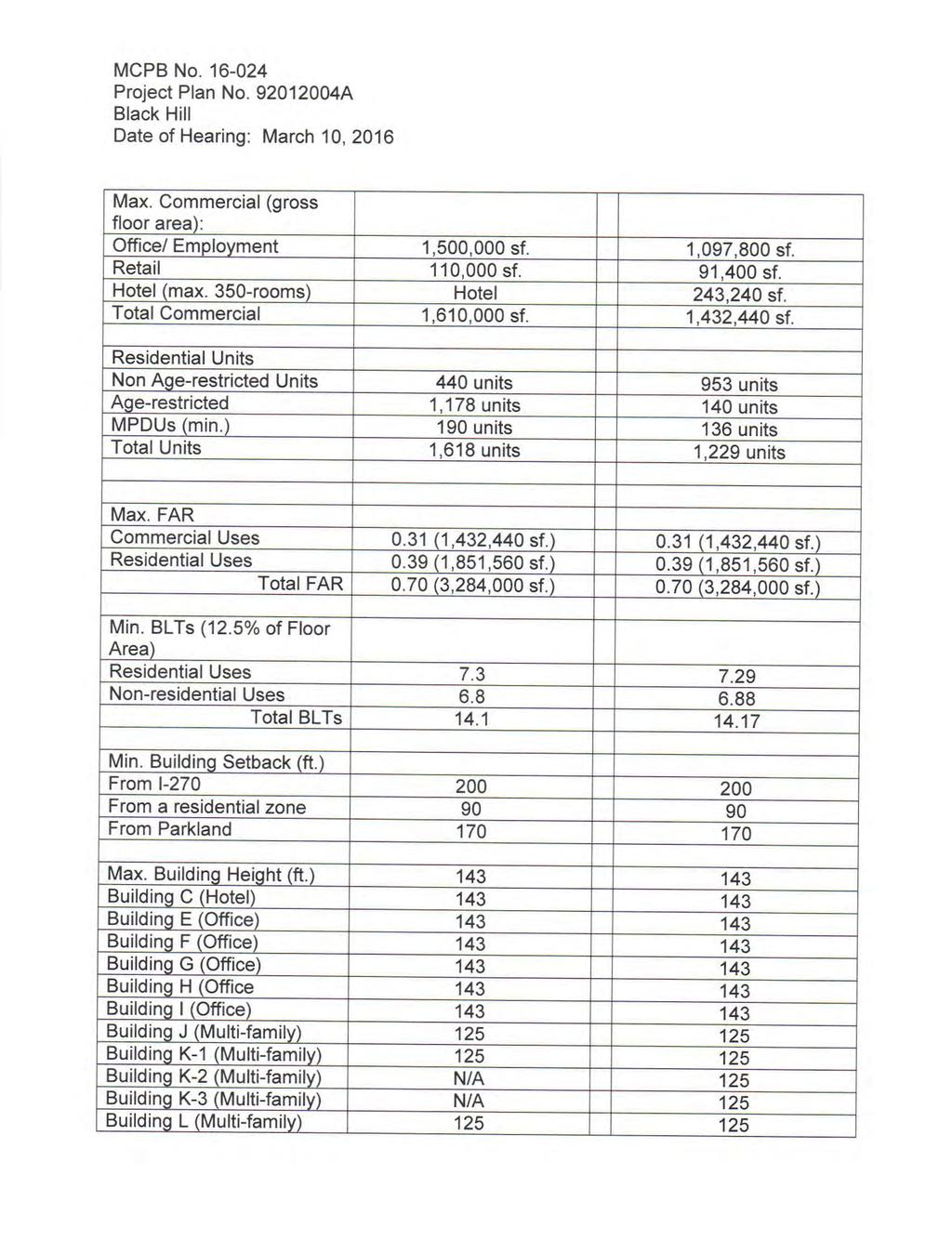
51
52
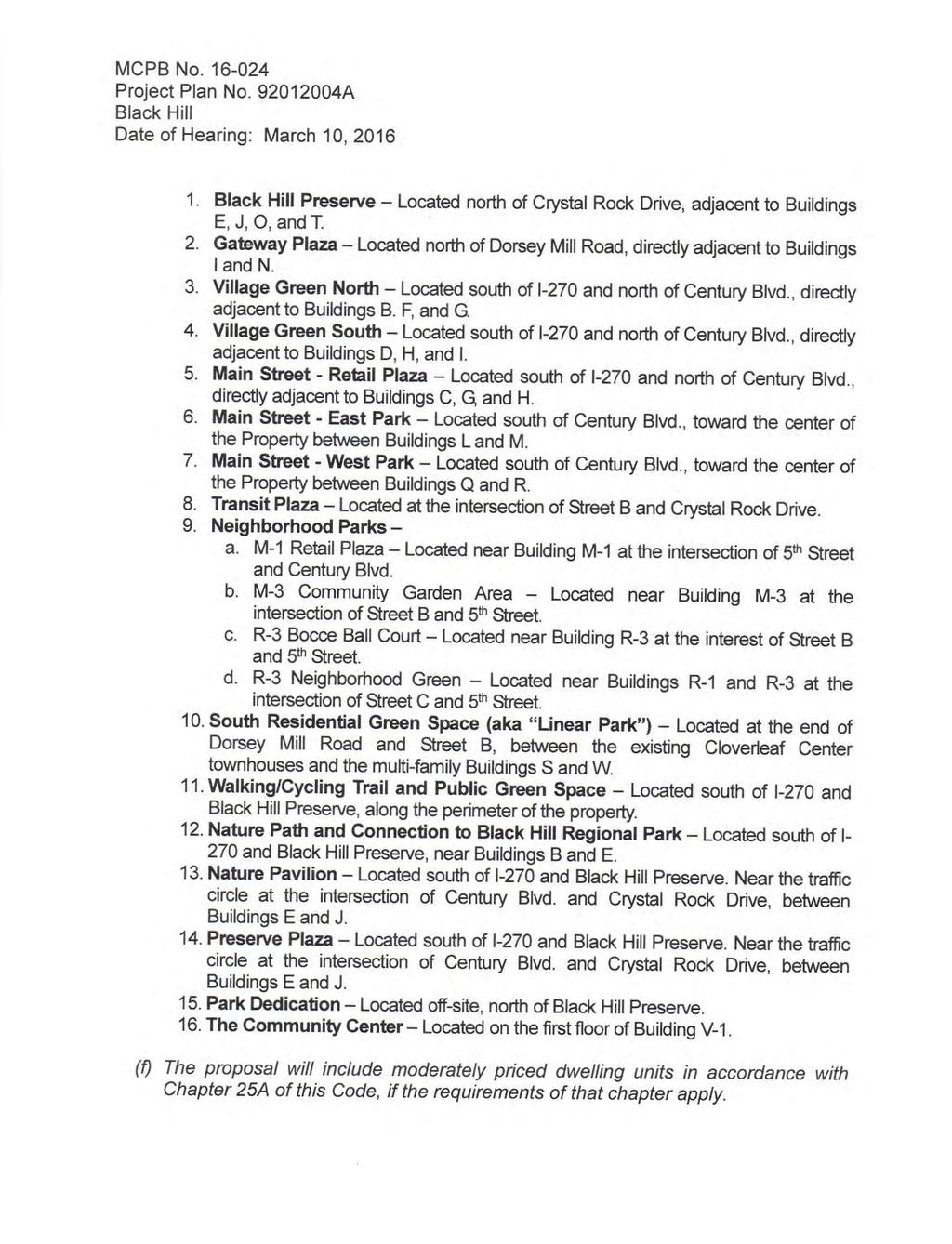
53
54
55
56
57
58 4lM ontcounnv Couxtv PreuNrNc Boeno lh F. M A RYI.AN I) -NA'lt()NA l. CAPII Al. PARK AN D l'l-a N^-lN C CO M N{ SSI()N M CPB No Prelim inary Plan Am endm ent No A Black Hill Date of Hearing: M arch 10, 2016 M AY 3 20f6 RESO LUTIO N W HEREAS, under M ontgom ery County Code Chapter 50, the M ontgom ery County Planning Board is authorized to review prelim inary plan applications; and W HEREAS, in June 2013, the Planning Board, by Resolution M CPB No ' approved Prelim inary Plan No , creating 1'llots for m ixed-use developm ent wlttr j,o SZ,AO O square feet of office use, 91,400 square feet of retailuse,243'240 square feet of hoteluse, and 1,618 totalresidentialunits (including 190 M PUDs) on acres of land in the TM X-2 zone, located north of Father Hurley Boulevard, east of crystalrock Drive and west of l-270 ("subject Property"), in the G erm antown Em ploym ent Area Sector Plan ("Sector Plan") area; and W HEREAS, on January 23, 2015, Black HillG erm antown, LLP, c/o Lerner Enterprises ("Applicant") filed an application for approvalof an am endm ent to the previously approved Prelim inary Plan(s) to m odify the traffic study to reflect changes to ihe office, assisted living facility, and residentialuses (non age-restricted), update the Adequate Public Facilities (APF), m odify the conditions of approval, and storm water m anagem ent (SW M ) concept for the Subject Property; and W HEREAS, Applicant's application to am end the Prelim inary Plan was designated Prelim inary Plan No A, Black Hill("Prelim inary Plan," "Am endm ent," or "Application"); and W HEREAS, following review and analysis of the Application by Planning Board staff ("Staff') and other governm entalagencies, Staff issued a m em orandum to the planning Board, dated February 29,2016, setting forth its analysis and recom m endation for appr6valof the Application, subject to certain conditions ("Staff Report"); and W HEREAS. on M arch 10, 2016, the Planning Board held a public hearing on the Application at which it heard testim ony and received evidence subm itted for the record on the Application; and '+lt 495.4(fi5 CParkandPlannin g.org E-M ail: m cp-chaim an@ m ncppc.org LL Fax:

59 M CPB No Prelim inary Plan No A Black Hill Page2 W HEREAS, on M arch 10, 2016, the Planning Board voted to approve the Application subject to certain conditions, on m otion of Com m issioner Presley, seconded by Com m issioner Fani-G onalez with a vote of 5-0; Com m issioners Anderson, Dreyfuss, Fani-G onalez, Presley, and W ells-harley voting in favor. NO W, THEREFO RE, BE lt RESO LVED that the Planning Board APPRO VES Prelim inary Plan Am endm ent No A to m odify the traffic study, revise the APF, m odify the conditions of approval, and the SW M concept. The following conditions will supersede the originalconditions of approval:1 1) Approvalunder this Prelim inary Plan is lim ited to 12 lots and 3 parcels for a m axim um of 1,097,800 square feet of office space, 91,400 square feet of retail space, a 350-room hotel, and a totalof 1,229 residentialunits (including 12'5% M PDUs). No m ore than 140 of the units dedicated to Senior Adult housing units. 2) The Housing and Related Facilities for Senior Adults, hereinafter referred to as senior Adult housing, m ay not be converted into non age-restricted units without first revising the traffic study for the approved Project and Prelim inary Plans. occupancy of the senior Adult housing is lim ited to the definition (section 59-A- 2.'l) in the Zoning O rdinance. Senior Adults are defined as persons 62 years and older. 3) The Prelim inary Plan m ust com ply with allconditions of approvalfor the Project Pfan No A.. 4) Prior to the release of the first building perm it for Phase 2 of the developm ent, as specified in the Project Plan, the Applicant m ust subm it design details to the M ontgom ery County Departm ent of Transportation ('M CDO T) and the State Highway Adm inistration ('SHA) and constructthe following roadway im provem ents to the extent required by M CDO T and SHA: a. construct crystalrock Drive and century Boulevard to fullwidth standards through the Property in accordance with M ontgom ery county Departm ent of perm itting Services approved phased Black HillCrystalRock Drive and Century Boulevard Public Roadway Plans. b. The Applicant m ust construct the following im provem ents at the intersection of Ridge Road (M D 27) and O bservation Drive: o Restripe a second left-turn lane on southbound O bservation Drive eastbound M D 27.. Provide necessary traffic signalm odifications. c. The Applicant m ust participate on a pro rata share to provide the following im provem ents at the M D 355/ W est O ld Baltim ore Road intersection' l.w ideneastboundapproachofw esto dba tim oreroadtoprovidefor a separate right-turn lane to southbound M D 355. I For the purpose of these conditions, the term "Applicant" shallalso m ean the developer'the owner or any successor(s) in interest to the term s of this approval.

60 M CPB No Prelim inary Plan No A Black Hill Page 3 2. W iden the northbound approach of M D 355 to provide for a separate left{urn lane on to westbound W est O ld Baltim ore Road. 3. W iden the southbound approach of M D 355 to provide separate rightturn lane to westbound W est O ld Baltim ore Road. 4. Installtrafiic signalif warranted by the background developm ent. 5) Prior to the release of the building perm it which contains the 371st residentialunit in Phase 2 of the developm ent as specified in the Project Plan (excluding the assisted living units), the Applicant m ust subm it 70% design com pletion details to SHA and M CDO T for the M D 1 18/M D 355 intersection to construct the following im provem ents: l. O n M D 355, construct a third southbound through/right-turn lane, ll. O n M D 355, construct a second southbound left-turn lane to G erm antown Road (M D 118). lll. O n westbound G erm antown Road (M D 118), construct a separate right turn lane on to northbound M D 355. lv. Provide necessary traffic signalm odification These im provem ents m ust be com pleted prior to the issuance of any use and occupancy perm it exceeding the 549th residentialunit (excluding the assisted living units). 6) Prior to the release of the building perm it which contains the 371st unit in Phase 2 of the developm ent as specified in the Project Plan (excluding the assisted living units), the Applicant m ust com plete 100% design to SHA and M CDO T and posting of bonds at M D 27lM D 355 to construct the following im provem ents: ' l. Construct a second dedicated eastbound left-turn lane on M D 27 to northbound M D 355. ll. Provide necessary traffic signalm odifications. These im provem ents m ust be com pleted prior to the issuance of any use and occupancy perm it exceeding the 549th residentialunit (excluding the assisted living units). 7) Prior to release of each building perm it after Phase 2A, excluding the assisted living units, the Applicant m ust subm it to DPS a certified running tabulation of the vehiile trips associated with the individualbuilding square footage_ and the cum ulative totalof vehicle trips associated with each building perm it pulled on the Property. Prior to the vehicle threshold being m et, the Applicant m ust construct the following im provem ents before the release of the triggering building perm it. a. Prior tothe release of any building perm it exceeding 22o/o of the totalpeak hourtrips(549vehic etripsintheam or5l2vehic etripsinthepm ' whichever threshold is m et first) for the developm ent as specified in the Prelim inary Plan, the Applicant m ust construct the following im pfovem ents at the intersection of Father Hurley Boulevard and CrystalRock Drive: l. Provide necessary traffic signalm odifications as per M CDO T'
 for the developm")
61 M CPB No Prelim inary Plan No A Black Hill Page 4 ll. Construct a second dedicated northbound right-turn lane on Crystal Rock Drive to eastbound Father Hurley Boulevard. b. Prior to the release of any building perm it exceeding 30% of the totalpeak hour trips (749 vehicle trips in the AM or 698 vehicle trips in the PM, whichever threshold is m et first) for the developm ent as specified in the Prelim inary Plan, the Applicant m ust construct the following im provem ents at the intersection of M D 118 and M D 117: l. Construct a second northbound left turn lane on G erm antown Road (M D1 18) onto westbound Clopper Road (M D 117). ll. Provide necessary haffic signalm odifications. c. At the Ridge Road (M D 27)lBrink Road intersection: i. Participate in the construction of a second westbound through lane on Brink Road. ii. Provide necessary traffic signalm odifications. 8) The Applicant m ust show on the record plat a parcelfor the following.private streets as wellas construct the roads to the design standards specified below: a. Private street A with a m inim um parcelwidth ol37.34 feet from 1st street to 5th Street. Private Street A m ust be constructed to M ontgom ery County Departm ent of Transportation ("M CDO T") Road Code Standard M C-2003'09: Prim ary/principalsecondary Residentialstreet M odified as shown on the Certified Prelim inary Plan. b. private Street B with a m inim um parcelwidth of feet from CrystalRock Drive to sth Street. Private Street B m ust be constructed to M ontgom ery County Departm ent of Transportation ('M CDO T) Road Code Standard M C : Prim ary/principalsecondary Residentialstreet M odified as shown on the Certified Prelim inary Plan. c. Private street c with a m inim um parcelwidth oi feet from crystalrock Drive to Sth street. Private Streetc m ust be constructed to M CDO T Road code standard M C : Prim ary/principalsecondary Residentialstreet M odified as shown on the Certified Prelim inary Plan' Private 1st Street with a m inim um parcelwidth of feet from Century Boulevard to Street A. Private 1st Street m ust be constructed to M CDO T Road code standard M C : Prim ary/principalsecondary Residential Street M odified as shown on the Certified Prelim inary Plan. private 2nd Street with a m inim um parcelwidth of feet from Century Boulevard to street A. Private 2nd Street m ust be constructed to M CDO T Road code standard M C : Prim ary/principalsecondary Residential f. g. Street M odified as shown on the Certified Prelim inary Plan. private 3'd Street with a m inim um parcelwidth of feet from century Boulevard to street A. Private 3d Street m ust be constructed to M CDO T Road code standard M C : Prim ary/principalsecondary Residential Street M odified as shown on the Certified Prelim inary Plan' private 4th street with a m inim um parcelwidth of feet from century Boulevard to street A. Private 4th street m ust be constructed to M CDO T

62 M CPB No Prelim inary Plan No A Black Hill Page 5 Road Code Standard M C : Prim ary/principalsecondary Residential Street M odifled as shown on the Certified Prelim inary Plan. h. Private 5th Street with a m inim um parcelwidth of feet from Street C to Street A. Private 5th Street m ust be constructed to M CDO T Road Code Standard M C : Prim ary/principalsecondary ResidentialStreet M odified as shown on the Certified Prelim inary Plan. i. Private M ain Street (North and South sections) with a m inim um parcelwidth of feet from Street C to StreetA. Private M ain Street m ust be constructed to M CDO T Road Code Standard M C : Prim ary/principal Secondary ResidentialStreet M odified as shown on the Certified Prelim inary Plan. 9) The Planning Board accepts the recom m endations of the M ontgom ery County Departm ent of Perm itting service (M CDPS) W ater Resources Section in its storm water m anagem ent concept letter dated Novem ber 16'2012'and hereby incorporates them as conditions of approval. The Applicant m ust com ply with each of the recom m endations as set forth in the letter, which the M CDPS W ater Resources section m ay am end if the am endm ents do not conflict with other conditions of site Plan approval. The M CDPS W ater Resources Section will revrew, approve, and inspectalllandscaping within the Storm W ater M anagem ent easem ents and facilities. 10)Finallocation and num ber of M PDUs to be determ ined at the tim e of site Plan. ttitne Rpplicant m ust provide proof of purchase and/or paym ent of the required 'BLTS within each phase of developm ent in accordance with the site Plan conditions. 12)The record plat m ust reflect the following: private streets from back of curb to back of curb to be located within separate parcels; private streets and adjacent sidewalks to be included within a public use and access easem ent' 13)The record plat m ust reflect a category easem ent over allareas of stream 'valley buffeis and forest conservation as shown on the approved forest conservation plan. 14)The record plat m ust reflect allareas under Hom eowners Association (HoA) ownership, if applicable. 1S)The finalnum ber and location of buildings, dwelling units, on-site parking, site circulation, sidewalks, and bike paths willbe determ ined at Site Plan' 16)ln the event that a subsequent site Plan approval _substantially m odifies the subdivision shown on the approved Prelim inaryplan with respect to lot configuration, location or right-of-way width or alignm ent, or an increase in units or sql"re footage above those specified in Condition #'1, the Applicant m ust obtain approval6f a Prelim inary Plan am endm ent prior to certification of the Site Plan. 17)At the tim e of Site Plan, the Applicant m ust com ply with seclion_59-c ot the Zoning ordinance regarding specialregulations for use of BLT Developm ent Rights.
The Adequate Public Facility (\"APF\") review for the Prelim inary Plan willrem ain valid for a totalof 145 m onths (12 years) from the originalinitiation date (August")
63 M CPB No Prelim inary Plan No A Black Hill Page 6 18)The Adequate Public Facility ("APF") review for the Prelim inary Plan willrem ain valid for a totalof 145 m onths (12 years) from the originalinitiation date (August 8,2013) of the Planning Board Resolution according to the following schedule: l. W ithin 85 m onths (7 years) - lssuance of building perm its for Phases I and ll as identified by Project Plan. ll. Beyond 85 m onths (years 7-12) - issuance of building perm its for all rem aining developm ent. 1 9)The Subject Property is within the Seneca Valley High SchoolCluster area. The 440 high rise m ulti-fam ily units approved under Resolution M CPB are subject to a SchoolFacility Paym ent at the elem entary schoollevelpursuant to the Subdivision Staging Policy in effect for FY The 649 low rise m ultifam ily units (and 140 senior housing units) approved under this Prelim inary Plan are not subject to a schoolfacility Paym ent pursuant to the subdivision Staging Policy in effect for FY BE lt FURTHER RESO LVED that having considered the recom m endations and findings of its Staff as presented at the hearing and as set forth in the Staff Report' which the Board hereby adopts and incorporates by reference (except as m odified herein), and upon consideration of the entire record, the Planning Board FINDS, with the conditions of approval, that: 1. The Pretim inary Ptan substantially conform s to the Sector Plan. The sector Plan contains recom m endations for roadway, transit, and bikeway facilities. crystalrock Drive and century Boulevard willboth function as a business district street (B-11) with four lanes (two in each direction) and a rightof-way of 100 feet. Dorsey M illroad extended willfunction as a business district streeilu-tt; with four lanes (two in each direction and right-of-way of 150 feet. Dorsey M illroad extended willalso include a 50 foot transitway for the future CCT jnd a shared-use path (SP-66). In accordance with the M andatory Referral (M R ), Dorsey M illroad extended bridges over l-270, and is proposed to h"ue separaied bicyile lanes (also known as a cycle track) on both sides of the road and a shared use path on the south side of the road. This is consistent with the current recom m endations in the sector Plan, but also provides an enhancem ent with separated bicycle lanes. 2. Public facilities willbe adequate to support and service the area of the approved subdivision. The site is located within the Seneca Valley schoolcluster. The public schools within this cluster are reviewed on an annualbasis. Based on the m odifications in this Application, a schoolfacilities paym ent is required for the 440 high-rise m ultifam ily unit; however, is not required for the 649 low-rise m ulti-fam ily units. The Applicant m ust m ake a schoolfacilities Paym ent to M CDPS for the 440 high-

64 M CPB No Prelim inary Plan No A Black Hill Page 7 rise m ulti-fam ily units at the elem entary schoollevel. The tim ing and am ount of the paym ent willbe in accordance with Chapter 52 of the M ontgom ery County Code. The office and residentialuses willbe reduced, and the num ber of beds in the assisted living facility willbe increased. The residentialm ix willbe m odified to allow for allnon age-restricted m ulti-fam ily units. As a result of these changes, the developm ent willgenerate 118 additionaltrips in the AM peak hour and 114 additionaltrips in the PM peak hour. The retailspace is intended to support the developm ent and is not intended to attract any trips outside the developm ent, thus there is a 100% internalcapture of the retailtrips. The Prelim inary Plan will satisfy the LATR and TPAR requirem ents of the Adequate Public Facilities (APF) review, as conditioned. The traffic study was revised and subm itted (dated April 2015) to determ ine the im pact of the developm ent on the area transportation system. Twenty-one localintersections were identified as criticalintersections for analysis to determ ine whether they m eet the applicable congestion standard. The Brink Road/ Ridge Road intersection and the Frederick Road (M D 355)/ W est Baltim ore Road intersection were not reanalyzed with the updated traffic im pact study, because it did not exceed the CriticalLane Volum e (CLV) threshold, and the Applicant agreed to construct the im provem ents and com plete their m itigation requirem ent as conditioned in the originalprelim inary Plan approval. Adequate vehicular and pedestrian access is provided. Vehicular access to the propbrty is from CrystalRock Drive and Century Blvd. A 10-foot sidewalk willbe installed along the public right-of-way and connected into the existing pathways at the edges of the Property. This Property willbe served by public water and sewer system s, under the W -3 and S-3 categories, as allowed and approved by the county. wssc has accepted the conceptualdesign of the sewer and water supply system s. The Prelim inary Plan has been reviewed by the M ontgom ery county Fire and Rescue Services, who have determ ined that there is appropriate access for fire and rescue vehicles. Electricaland telecom m unications services are also available to serve the developm ent' 3. The size, width, shape, and orientation of the approved lots are appropriate for the location of the subdivision, taking into account the recom m endations included in the applicable M aster Plan, and for the typeof developm ent or use contem plated. The size, shape, width, and orientation of the lots were reviewed to determ ine if the lots are appropriate given the location of this developm ent for the types and uses intended for each lot. As labeled on the Prelim inary Plan, Lots 15, 18, 19, and 20 were m odified to accom m odate a different building footprint and housing
65 M CPB No. ' Prelim inary Plan No Black Hill Page 8 type. M ulti-fam ily residentialunits are provided within these lots and the urban grid pattern is consistent with the previous approval. The lots are appropriately sized to m eet the Sector Plan recom m endations for building m assing and com patibility to the transit station. 4. The Application satisfies allthe applicable requirem ents of the Forest Conservation Law, M ontgom ery County Code, Chapter 22A. The FinalForest conservation Plan for this Property was originally approved in August 2013 as Site Plan No crystalrock- Public Roads InfLstructure plan, and was subsequently updated to include the Dorsey M ill Road intersection (site Plan No ) in Decem ber The Prelim inary Plan conform s to the chapter 22A, because it is unchanged from the am ended Project Plan No approval. 5. Allstorm water m anagem ent requirem ents shallbe m et as provided in chapter 19'artic e,tit e..storm waterm anagem ent'sectionl9-20through The originalsw M concept was approved in Novem ber 2012 and uses a variety of techiiques to m eet the ESD requirem ents. In accordance with the original swm approval, each respective site Plan application willrequire a subsequent SW M approval. BE lt FURTHER RESO LVED that this Resolution constitutes the written opinion of theboard in this m atter, and the date of this Resolution is IIAY (*rti"n i. the date that this Resolution is m ailed to allparties of record); and BE TFURTHERRESoLVEDthatanypartyauthorizedby awtotakean adm inistrative appealm ust initiate such an appealwithin thirty days ofthe date of this ilsotution, consistent with the proceduralrules for thejudicialreview of adm inistrative agency decisions in Circuit Court (Rule 7-203, M aryland Rules)
66 M CPB No Prelim inary Plan No Black Hill Page 9 CERTIFICATIO N This is to certify that the foregoing is a true and correct copy of a resolution adopted by the M ontgom ery County Planning Board of the M aryland-nationalcapitalpark and Planning Com m ission on m otion of Com m issioner Presley, seconded by Com m issioner Dreyfuss, with Chair Anderson and Com m issioners Dreyfuss and Presley voting in favor, and Vice Chair W ells-harley and Com m issioner Fani-G onz6lez absent, at its regular m eeting held on Thursday, April21, 2016, in Silver Sp-gi M ontgom ery County Planning Board
67 M R. RICHARD BRUSH, M ANAG ER M CDPS-W ATER RES. PLAN REVIEW 255 RO CKVII"LE PIKE 2ND FLO O R RO CKVTtlE, M D M S. LISA SCHW ARTZ DHCA 1O O M ARYIAND AENUE 4rfiFLO O R RO CKV LT-E, M D M S. SUSAN SCALA-DEM 8Y M CDPS.ZO NING 255 RO CKVII.LE PIKE 2ND FLO O R RO CKV[-.E, M D M R. G REG LECK M CDO T 1O O EDISO N PARK O RIVE 4TH FLO O R G AITHERSBURG, M D M R. ATIQ PANJSHIRI M CO PS.RIG HT.O F-W AY PERM ITTING 355 RO CKV - -E PtKE 2No F -O O R RO CKVII.LE, M D M S. CHRISTINA CO NTRERAS M CDPS-LANO DEVELO PM ENT 255 RO CKVII.LE PIKE 2ND FI.O O R RO CKVTLLE, M D M R. RICHARD BRUSH. M ANAG ER M CDPS-SEDIM ENT/STO RM W ATER INSPECTIO N & ENFO RCEM ENT 255 RO CKVTU.E PtKE 2flo FTO O R RO CKV -IE, M D M R. ESHAN M O TAZEO I M CDPS-SITE PI.AN ENFO RCEM ENT 255 RO CKVILLE PIKE 2Io FLO O R RO CKV LT.E, M D M R. G ENE VO N G UNTEN M CO PS-W EL & SEPTTC 255 RO CKVIL -E Pt(E 2I{D FLO O R RO CKV TLE, M D M R. CHRISTO PHER ANDERSO N M R. AI.AN SO UKUP JAM ES PO IICARO M PDU M ANAG ER, DHCA M CDDEP.W ATER & W ASTEW ATER PO LICY LERNER ENTERPRISES 1O O M AYLAND AVENUE 255 RO CKVII,I.E PIKE 2O O O TO W ER O AKS EO ULEVARD 4niFLO O R SUTTE 120 8rx FLO O R RO CKV I E, M D RO CKV. E, M D RO CKV - E, M D 20E52 M IG UET IRAO I.A M IKE PIITT RO BERT BREW ER HO RD CO PI.AN M ACHT M ACRIS, I{ENDRICKS & G LASCO CI(, PA I-ERCH, EARLY & BREW ER 750 E PRATT STREET 9220 W IG HRM AN RO AD 3 BETHESO A M ETO R CENTER sutte 1100 sutte 120 sutte 450 EALTIM O RE, M D M O NTG O M ERY VIII.AG E, M D BETHESDA, M D JAM ES PO TICARO BI.ACK HItI.S G ERM ANTO W N, LI.I.C 2O O O TO W ER O AKS BO UI"EVARD 8TH FLO O R RO CKVILI.E, M D CHRIS SCHEIN HO RD CO PIAN M ACHT 750 E PRATT STREET sutte 1100 BALTIM O RE, M O FRANK ANDRE HO RO CO PTAN M ACHT 750 E PRATT STREET sutte 1100 BAI.TIM O RE. M D CHRIS TRUNEULI. wel.ts & AssoctATEs M ICHAEL CO NI.EY whl 1420 SPRING HILI- RO AD 34(M I.EI.AND STREET SUITE 610 wsons, va CHEVY CHASE. M D 20815
68
69
70
71
72
73
74
75
76
77
78

79 Department of Permitting Services Fire Department Access and Water Supply Comments DATE: TO: FROM: RE: 17-May-18 Stephen Crum - scrum@mhgpa.com Macris, Hendricks & Glascock Marie LaBaw Black Hill - Viasat PLAN APPROVED 1. Review based only upon information contained on the plan submitted 17-May-18.Review and approval does not cover unsatisfactory installation resulting from errors, omissions, or failure to clearly indicate conditions on this plan. 2. Correction of unsatisfactory installation will be required upon inspection and service of notice of violation to a party responsible for the property.
80 DPS-ROW CONDITIONS OF APPROVAL May 29, ViaSat Contact: Sam Farhadi at We have reviewed site and landscape plans files: 07-SITE C2.01.pdf V3 uploaded on/ dated 5/25/2018 and 08-LL L2.01.pdf V4 uploaded on/ dated 5/25/2018. The following needs to be addressed prior to the certification of site plan: 1. Remove all pavement markings in the public ROW from the site plan. and the followings need to be conditions of the certified site plan: 1. Proposed non-standard items in the ROW are limited to benches and landscaping (pavements are subject to notes on site plan sheet C2.01): a. they are subject to review and approval by MCDPS at the time of ROW permit; b. if accepted, ROW permit and maintenance and liability agreement are required. 2. Traffic Mitigation Agreement: MCDOT/Commuter Services provides information to employees throughout the County, and recommends that the Applicant be required to work with Commuter Services to adopt a Transportation Demand Management program through a Traffic Mitigation Agreement (TMAg). The proposed office is part of the overall multi-phased, mixed-use Black Hill development, which is intended to be a Transit Oriented Development. The location of this project is in a Transit Mixed-Use Zone, the project is proximate to the Germantown Transit Center, and the site was chosen in part due to its proximity to a future CCT station. Therefore, it is critical that Commuter Services have the ability to work with the building owners/management to inform employees and visitors at the Project about, and promote alternatives to, single occupancy auto commuting. The TMAg required as part of the conditions of approval for the entire Black Hill mixed-used development was executed in May Tribute at Black Hill, located within the Black Hill development, was also required to execute a separate TMAg because that portion of the development was ultimately under separate ownership (the TMAg was executed in 2017). Similarly, because the VIASAT property is owned by Black Hill but will be purchased by VIASAT following approval of the development plans, a separate TMAg will need to be executed prior to issuance of any building permits. TMAg provisions will include but not be limited to: Identification of a point of contact for TDM efforts Provision of information and access for events to enable promotion of alternative modes
81 DPS-ROW CONDITIONS OF APPROVAL May 29, 2018 Displays (Real Time/Dynamic and Static Transit and other TDM Information) Employee Parking Management 3. Bikesharing: MCDOT/ Commuter Services recommends that Applicant not be required to provide space on-site for a bikeshare station, as the project is not projected to generate sufficient demand on its own to support a full station. However, It is recommended that Applicant be required to contribute to the planned network of bikeshare stations in the Black Hill development with a payment for half the capital cost of a 19-dock bikeshare station, or approximately $34,000. The intra-development network in Black Hill will ultimately connect to the CCT station and the Germantown Transit Center. MCDOT will select a location for a bikeshare station in this portion of Black Hill that will serve the VIASAT office building and other nearby uses, based upon the requirements of the bikesharing system. The exact location of the bikeshare station to which Applicant s contribution will be applied will be determined once bikeshare becomes operational in Germantown. The Applicant will also be required to take other actions in concert with the MCDOT to promote use of bikesharing among employees and visitors at the Project.
82 Berbert, Benjamin From: tom milavec Sent: Monday, May 21, :13 PM To: Berbert, Benjamin Subject: Re: Plan Application : Hi Ben, Thank you for the quick response! After reading this I am finding some discrepancies from my notes of the conversation. If you don t mind I would like to add clarifications of this so you can amend or take into consideration for this plan: Correction to Note 9: This is not correct the question was How will this current site plan and architecture contribute to the walkability of the Black Hill neighborhood? As this is a review on the site plan the neighborhood has been told by the developer and county that this masterplan and subsequent lots will have a level of mixed use and walkability. Unfortunately, this site plan does not meet that expectation in any way. Due to the security concerns this building will be a fortress similar to the data center just south of this property, thus the future architecture and fencing will be bold and create a sense of opacity that is not conducive to a walkable or approachable mixed use neighborhood. Fences along a public right of way, imposing architecture and a lack of anything mixed use in our mind does not meet the expectation set forth by the development and the masterplan. I am sad they left out the real discussion on this makes sense as it was not positive to their plan Correction to Note 10: This is not correct the question DID address the design and appearance of the suburbanesque nature of the site plan and architecture presented. The overwhelming response was that this feels suburban and the client / landowner clearly don t have concern for that fact. If the goal of the masterplan and development is to create a walkable, mixed use, pedestrian friendly and generally a new model of office/residential development this plan falls flat and brings back the old suburban ideals of office parks. Interestingly enough, exactly like the old dated office parks not even a mile down the road which are currently unoccupied in a great number. This proposal is THE typical suburban office park proposal of walling off the public right of way and creating an enclave at the FRONT DOOR of a new mixed use development. It is suburbanesque in every sense of the word and the community has not seen any real modifications addressed to address this. Big fences, completely dead space along pedestrian right of ways this is not walkable or mixed use especially when the majority of activity across the street will be bus and human walking. This design is for cars driving at least 55mph. I am sad they left out the real discussion on this makes sense as it was not positive to their plan I am disheartened at the fact that these are clearly manipulated notes from Jody S. Kline to offer the meeting discussion in a positive note. I can assure you that Nicole and I were not pleased with the presentation and were vocal about the major holes in the plan presented and community expectations. This seems like a quick pitch from the land owner to move something on this development sadly at the expense of creating a real new neighborhood. 1
83 This site plan should not be approved until they address some major items to ensure this architecture matches the masterplan and community goals. It starts with the site plan. If they don t address and get the human occupied zone correct I am confidant the architecture will be brutal and we ll have another uncomfortable and sad piece of architecture in this neighborhood. It makes me think that we might need to discuss a design review board for this development. Thank you for your time Ben please let me know if anything sparks interest, I m happy to discuss in more detail. My main goal here is make sure the information is represented correctly and you and your team hear real public comment (especially since there was no county representative or public in attendance). Makes it easy for the facts and concerns to slip past into nothing. Tom Milavec On May 21, 2018, at 8:10 AM, Berbert, Benjamin <benjamin.berbert@montgomeryplanning.org> wrote: Good morning Mr. Milavec, I have attached the correspondence that was sent to us from the public pre submission meeting. I can t speak for whether the above captured every question or comment, but generally these submitted minutes are summaries and not full transcripts. If you feel that comments of yours have been left out, or if you wish to submit your comments to our office we could be glad to ensure they become a part of the record. Ben Berbert Planner Coordinator, Area <image001.png> From: tom milavec <tom.milavec@gmail.com> Sent: Sunday, May 20, :19 AM To: Berbert, Benjamin <benjamin.berbert@montgomeryplanning.org> Subject: Plan Application : Hello Benjamin, I am writing you as you are indicated as the lead reviewer for the ViaSat application located on Century Boulevard, 1200 East of Crystal Rock Drive in Germantown, MD. As a property owner in the adjacent townhome development I attended the site plan public meeting late last year. While I was only one of two members of the public in attendence I do remember a legal representative from the client or land developer in attendance taking notes on the discussion that he said would be entered into record and circulated for the site plan review. 2
84 I have not seen any record of my comments circulated nor am I able to find this in any public record available under this plan review. Can you provide me with some more detail on the notes taken at that public meeting and if you were not presented with a record I m happy to share my comments with you to ensure that it is part of public record for this site plan submission as they were critical of the plan presented. I want to ensure that public comment is reviewed and available to you and your team. Thank you, Tom Milavec Cloverleaf Townhome Owner Germantown, MD <05 PMTG pdf> 3
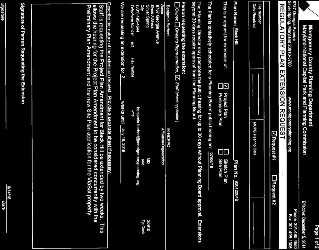
85
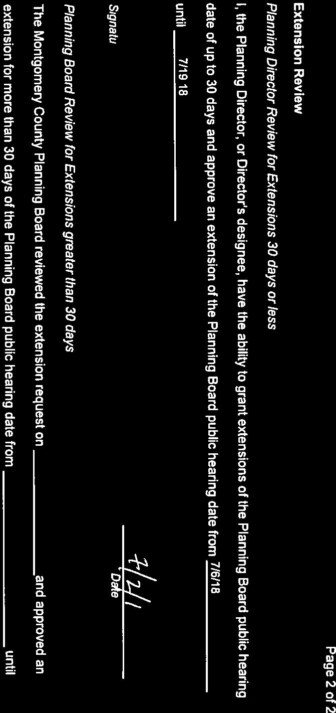
86
MONTGOMERY COUNTY PLANNING DEPARTMENT THE MARYLAND-NATIONAL CAPITAL PARK AND PLANNING COMMISSION
 MONTGOMERY COUNTY PLANNING DEPARTMENT THE MARYLAND-NATIONAL CAPITAL PARK AND PLANNING COMMISSION MCPB Item No. Date: 3.10.2016 Site Plan 820160040 Nora School Parker Smith, Planning Technician, Area 1,
MONTGOMERY COUNTY PLANNING DEPARTMENT THE MARYLAND-NATIONAL CAPITAL PARK AND PLANNING COMMISSION
 MONTGOMERY COUNTY PLANNING DEPARTMENT THE MARYLAND-NATIONAL CAPITAL PARK AND PLANNING COMMISSION MCPB Item No.: 11 Date: 06-28-18 Black Hill Infrastructure Site Plan Amendment No. 82013025C Benjamin Berbert,
MONTGOMERY COUNTY PLANNING DEPARTMENT THE MARYLAND-NATIONAL CAPITAL PARK AND PLANNING COMMISSION
 MONTGOMERY COUNTY PLANNING DEPARTMENT THE MARYLAND-NATIONAL CAPITAL PARK AND PLANNING COMMISSION MCPB Item No. Date: 06-12-14 King of the Nations Christian Fellowship Church: Limited Site Plan Amendment
MONTGOMERY COUNTY PLANNING DEPARTMENT THE MARYLAND-NATIONAL CAPITAL PARK AND PLANNING COMMISSION
 MONTGOMERY COUNTY PLANNING DEPARTMENT THE MARYLAND-NATIONAL CAPITAL PARK AND PLANNING COMMISSION MCPB Item No. Date: 12-10-15 Leisure World Clubhouse II Addition Fitness Center, Limited Site Plan Amendment
MONTGOMERY COUNTY PLANNING DEPARTMENT Newell Street. Site Plan Item #2. Maryland-National Capital Park and Planning Commission
 8001 Newell Street Site Plan 820140020 Item #2 December 19, 2013 Redlined Conditions 1. The Applicant must comply with the conditions of approval for Project Plan 920130020 in MCPB Resolution No. 13-74.
MONTGOMERY COUNTY PLANNING DEPARTMENT
 MONTGOMERY COUNTY PLANNING DEPARTMENT THE MARYLAND-NATIONAL CAPITAL PARK AND PLANNING COMMISSION MCPB Item No.: Date: 5-03-18 Pike and Rose, Phase I: Site Plan Amendment No. 82012002D Rhoda Hersson-Ringskog,
MONTGOMERY COUNTY PLANNING DEPARTMENT THE MARYLAND-NATIONAL CAPITAL PARK AND PLANNING COMMISSION
 MONTGOMERY COUNTY PLANNING DEPARTMENT THE MARYLAND-NATIONAL CAPITAL PARK AND PLANNING COMMISSION MCPB Item No.: 9 Date: 07-20-17 Topgolf - Germantown: Preliminary Plan Amendment No. 12007065B and Site
MONTGOMERY COUNTY PLANNING DEPARTMENT THE MARYLAND-NATIONAL CAPITAL PARK AND PLANNING COMMISSION
 MONTGOMERY COUNTY PLANNING DEPARTMENT THE MARYLAND-NATIONAL CAPITAL PARK AND PLANNING COMMISSION MCPB Item No. Date: 10.25.18 Artery Plaza: Site Plan Amendment 81984002E SD Stephanie Dickel, Planner Coordinator,
MONTGOMERY COUNTY PLANNING DEPARTMENT THE MARYLAND NATIONAL CAPITAL PARK AND PLANNING COMMISSION
 MONTGOMERY COUNTY PLANNING DEPARTMENT THE MARYLAND NATIONAL CAPITAL PARK AND PLANNING COMMISSION MCPB Date: 03-10-16 Black Hill: Project Plan No. 92012004A, Preliminary Plan No. 12012021A, Site Plan No.
MONTGOMERY COUNTY PLANNING DEPARTMENT THE MARYLAND-NATIONAL CAPITAL PARK AND PLANNING COMMISSION
 MONTGOMERY COUNTY PLANNING DEPARTMENT THE MARYLAND-NATIONAL CAPITAL PARK AND PLANNING COMMISSION The Goddard School in North Bethesda Preliminary Plan Amendment 11996015B and Site Plan Amendment 82006005A
Clarksburg Square Road Extension
 Clarksburg Square Road Extension Preliminary Plan No. 120140060 Site Plan No. 820140050 Site Plan Amendment No. 82007022C (Clarksburg Town Center) Clarksburg SPA Water Quality Plan Mandatory Referral MR2015008
MONTGOMERY COUNTY PLANNING DEPARTMENT THE MARYLAND-NATIONAL CAPITAL PARK AND PLANNING COMMISSION
 MONTGOMERY COUNTY PLANNING DEPARTMENT THE MARYLAND-NATIONAL CAPITAL PARK AND PLANNING COMMISSION MCPB Item No. Date: 05-22-14 Consent Item - Park Potomac: Site Plan Amendment No. 82004015K MCS. Molline
MONTGOMERY COUNTY PLANNING DEPARTMENT THE MARYLAND-NATIONAL CAPITAL PARK AND PLANNING COMMISSION
 MONTGOMERY COUNTY PLANNING DEPARTMENT THE MARYLAND-NATIONAL CAPITAL PARK AND PLANNING COMMISSION Montgomery Auto Sales Park: Preliminary Plan No. 11985027A, Site Plan No. 820140130 and Site Plan No. 820140140
MONTGOMERY COUNTY PLANNING DEPARTMENT THE MARYLAND-NATIONAL CAPITAL PARK AND PLANNING COMMISSION
 MONTGOMERY COUNTY PLANNING DEPARTMENT THE MARYLAND-NATIONAL CAPITAL PARK AND PLANNING COMMISSION Ashton Market: Preliminary Plan No. 120180180 and Site Plan No. 820180160 Jonathan Casey, Senior Planner,
The subject site plan amendment proposes the following revisions to the approved site plan:
 PROPOSED AMENDMENT The subject site plan amendment proposes the following revisions to the approved site plan: 1. The building footprint was modified to accommodate the revised architectural design. 2.
MONTGOMERY COUNTY PLANNING DEPARTMENT THE MARYLAND-NATIONAL CAPITAL PARK AND PLANNING COMMISSION
 MONTGOMERY COUNTY PLANNING DEPARTMENT THE MARYLAND-NATIONAL CAPITAL PARK AND PLANNING COMMISSION MCPB Item No.: 5 Date: 06-29-17 Bradford s Landing, Site Plan No. 820170060 Sandra Pereira, RLA, Acting
Steve, Following are our notes from the first two meetings with Montgomery County Planning Group:
 To Steve Hatch Fax No. Telephone No. From Mike Stanley Date 10/16/17 Subject Minutes from Montgomery County Meetings File Distribution This is page 1 of 5 Memorandum/Discussion/Observations Steve, Following
MONTGOMERY COUNTY PLANNING DEPARTMENT THE MARYLAND-NATIONAL CAPITAL PARK AND PLANNING COMMISSION
 MONTGOMERY COUNTY PLANNING DEPARTMENT THE MARYLAND-NATIONAL CAPITAL PARK AND PLANNING COMMISSION MCPB Item No.: 2 Date: 12-19-13 Site Plan 820140020, 8001 Newell Street Neil Braunstein, AICP, Area 1, neil.braunstein@montgomeryplanning.org,
MONTGOMERY COUNTY PLANNING DEPARTMENT THE MARYLAND-NATIONAL CAPITAL PARK AND PLANNING COMMISSION
 MONTGOMERY COUNTY PLANNING DEPARTMENT THE MARYLAND-NATIONAL CAPITAL PARK AND PLANNING COMMISSION MCPB Item Date: 09/08/16 The Collection (Formerly Chevy Chase Center): Site Plan Amendment No. 82001013C,
MONTGOMERY COUNTY PLANNING DEPARTMENT
 MONTGOMERY COUNTY PLANNING DEPARTMENT THE MARYLAND-NATIONAL CAPITAL PARK AND PLANNING COMMISSION MCPB Item No.: 11 Date: 7-20-17 Burtonsville McDonalds: Site Plan No. 820150020 Jonathan Casey, Senior Planner,
Town Center. Block 5 Existing multifamily residential units are expected to remain.
 Area Guidelines Germantown s districts should be developed as distinct communities with unique features that are supported through the guidelines. The guidelines not only help distinguish these districts
MONTGOMERY COUNTY PLANNING DEPARTMENT
 MONTGOMERY COUNTY PLANNING DEPARTMENT THE MARYLAND-NATIONAL CAPITAL PARK AND PLANNING COMMISSION MCPB Item No. 4 Date: 12-15-16 CVS Derwood: Site Plan No. 820160150 Calvin Nelson, Jr., Planner Coordinator,
MONTGOMERY COUNTY PLANNING DEPARTMENT THE MARYLAND-NATIONAL CAPITAL PARK AND PLANNING COMMISSION
 MONTGOMERY COUNTY PLANNING DEPARTMENT THE MARYLAND-NATIONAL CAPITAL PARK AND PLANNING COMMISSION MCPB Item No. Date: 9/22/16 Ripley II: Sketch Plan Amendment No. 32015003A, Preliminary Plan No. 120160190,
MONTGOMERY COUNTY PLANNING DEPARTMENT THE MARYLAND NATIONAL CAPITAL PARK AND PLANNING COMMISSION
 MONTGOMERY COUNTY PLANNING DEPARTMENT THE MARYLAND NATIONAL CAPITAL PARK AND PLANNING COMMISSION MCPB Item No. 7 Date: 7.19.18 ZOM Bethesda, Preliminary Plan No. 120180140 and Site Plan No. 820180120 Matthew
MONTGOMERY COUNTY PLANNING DEPARTMENT THE MARYLAND-NATIONAL CAPITAL PARK AND PLANNING COMMISSION
 MONTGOMERY COUNTY PLANNING DEPARTMENT THE MARYLAND-NATIONAL CAPITAL PARK AND PLANNING COMMISSION MCPB Item No. Date: 1/26/12 Hanover Shady Grove, Sketch Plan 320120020 Joshua Sloan, Coordinator, Joshua.Sloan@MontgomeryPlanning.org,
MONTGOMERY COUNTY PLANNING DEPARTMENT
 MONTGOMERY COUNTY PLANNING DEPARTMENT THE MARYLAND-NATIONAL CAPITAL PARK AND PLANNING COMMISSION MCPB Item No. Date: 04/05/2018 850 Sligo Avenue Sketch Plan No. 320180090 Neil Sullivan, Planner Coordinator,
MONTGOMERY COUNTY PLANNING DEPARTMENT THE MARYLAND-NATIONAL CAPITAL PARK AND PLANNING COMMISSION
 MONTGOMERY COUNTY PLANNING DEPARTMENT THE MARYLAND-NATIONAL CAPITAL PARK AND PLANNING COMMISSION MCPB Item No. Date: 1/15/2015 Bethesda North Marriott Hotel and Conference Center: Limited Site Plan Amendment
MONTGOMERY COUNTY PLANNING DEPARTMENT THE MARYLAND-NATIONAL CAPITAL PARK AND PLANNING COMMISSION
 MONTGOMERY COUNTY PLANNING DEPARTMENT THE MARYLAND-NATIONAL CAPITAL PARK AND PLANNING COMMISSION MCPB Item No. 8 Date: 12-15-16 Montgomery Village Center Sketch Plan No. 320170020 TL Troy Leftwich, Senior
ARTICLE 6: Special and Planned Development Districts
 ARTICLE 6: Special and Planned Development Districts 6-10 Traditional Neighborhood Development (TND) District 6-10.10 Purpose and Intent The Traditional Neighborhood Development (TND) District provides
Gold Line Bus Rapid Transit Transit Oriented Development (BRTOD) Helmo Station Area Plan
 Helmo Station Area Plan") Appendix F Gold Line Bus Rapid Transit Transit Oriented Development (BRTOD) Helmo Station Area Plan Introduction and Purpose of the Plan The Gold Line Bus Rapid Transit facility is an eleven-mile dedicated
Appendix F Gold Line Bus Rapid Transit Transit Oriented Development (BRTOD) Helmo Station Area Plan Introduction and Purpose of the Plan The Gold Line Bus Rapid Transit facility is an eleven-mile dedicated
MONTGOMERY COUNTY PLANNING DEPARTMENT
 MONTGOMERY COUNTY PLANNING DEPARTMENT THE MARYLAND-NATIONAL CAPITAL PARK AND PLANNING COMMISSION MCPB Consent Date: 4-26-18 Cabin John Auto Park (N. Bethesda Home Depot), Site Plan Amendment No. 81980017A
MONTGOMERY COUNTY PLANNING DEPARTMENT THE MARYLAND-NATIONAL CAPITAL PARK AND PLANNING COMMISSION
 MONTGOMERY COUNTY PLANNING DEPARTMENT THE MARYLAND-NATIONAL CAPITAL PARK AND PLANNING COMMISSION MCPB Item No.: Date: 06/27/13 Site Plan No. 820130250: Crystal Rock Drive and Century Boulevard (Including
MONTGOMERY COUNTY PLANNING DEPARTMENT
 MONTGOMERY COUNTY PLANNING DEPARTMENT THE MARYLAND-NATIONAL CAPITAL PARK AND PLANNING COMMISSION North Bethesda Town Center Parcel G Site Plan No. 820180010 MCPB Item No.: Date: 01-25-18 Atul Sharma, Planner
MONTGOMERY COUNTY PLANNING DEPARTMENT THE MARYLAND-NATIONAL CAPITAL PARK AND PLANNING COMMISSION
 MONTGOMERY COUNTY PLANNING DEPARTMENT THE MARYLAND-NATIONAL CAPITAL PARK AND PLANNING COMMISSION MCPB Item No. Date: 05/12/2016 North Bethesda Conference Center Parking Structure, Mandatory Referral No.
MONTGOMERY COUNTY PLANNING DEPARTMENT THE MARYLAND NATIONAL CAPITAL PARK AND PLANNING COMMISSION
 MONTGOMERY COUNTY PLANNING DEPARTMENT THE MARYLAND NATIONAL CAPITAL PARK AND PLANNING COMMISSION MCPB Item No. 8 Date: 3.30.2017 Project Name: Lot 31/31A Bethesda, Site Plan Amendment, No. 82007018C Elza
MONTGOMERY COUNTY PLANNING DEPARTMENT THE MARYLAND NATIONAL CAPITAL PARK AND PLANNING COMMISSION
 MONTGOMERY COUNTY PLANNING DEPARTMENT THE MARYLAND NATIONAL CAPITAL PARK AND PLANNING COMMISSION MCPB Item No. 3 Date: 1.5.17 7272 Wisconsin Avenue: Sketch Plan Amendment No. 32016004A, Preliminary Plan
4 January 11, 2012 Public Hearing APPLICANT:
 . 4 January 11, 2012 Public Hearing APPLICANT: MID-ATLANTIC AUTO PROPERTY OWNER: DZR, LLC STAFF PLANNER: Leslie Bonilla REQUEST: Conditional Use Permit (truck rental, automobile service, and automotive/bulk
STATEMENT OF JUSTIFICATION CLARKSBURG PREMIUM OUTLETS AT CABIN BRANCH NORTH DISTRICT, PHASE
 STATEMENT OF JUSTIFICATION CLARKSBURG PREMIUM OUTLETS AT CABIN BRANCH NORTH DISTRICT, PHASE 1 Southwest Corner of Clarksburg Road and Interstate-270 Clarksburg, Maryland Application for Site Plan #820140160
DRAFT. October Wheaton. Design Guidelines
 October 2011 DRAFT Wheaton Design Guidelines 2 Draft - Design Guidelines - Wheaton Sector Plan Contents 04 Section 1: Introduction 06 Section 2: Context 08 Section 3: Design Guidelines 09 Goal 1: Create
ARLINGTON COUNTY, VIRGINIA
 ARLINGTON COUNTY, VIRGINIA County Board Agenda Item Meeting of September 19, 2015 DATE: September 11, 2015 SUBJECTS: Outdoor Café at Citizen Burger Bar A. SP# 418 Site Plan Amendment to modify an approved
Description of Preferred Alternative
 Chapter 2 Description of Preferred Alternative 2.1 Introduction This chapter of the programmatic Sammamish Town Center Sub-area Plan Final EIS provides a more detailed description of the Preferred Alternative
TABLE OF CONTENTS SITE DESCRIPTION 3 Vicinity 3 Site Analysis 4. PROJECT DESCRIPTION 5 Proposal 5
 TABLE OF CONTENTS SITE DESCRIPTION 3 Vicinity 3 Site Analysis 4 PROJECT DESCRIPTION 5 Proposal 5 PROJECT ANALYSIS 6 Master Plan 6 Transportation & Circulation 6 Environment 7 Development Standards 8 Community
MONTGOMERY COUNTY PLANNING DEPARTMENT THE MARYLAND-NATIONAL CAPITAL PARK AND PLANNING COMMISSION
 MONTGOMERY COUNTY PLANNING DEPARTMENT THE MARYLAND-NATIONAL CAPITAL PARK AND PLANNING COMMISSION MCPB Item No. 6 Date: 5-9-13 Site Plan No. 820130090, West Chevy Chase Heights Erin Grayson, Senior Planner,
Asbury Chapel Subdivision Sketch Plan
 Asbury Chapel Subdivision Sketch Plan PART 1: PROJECT SUMMARY Applicant: NVR Inc. Project Size: +/- 76.13 acres Parcel Numbers: 02101112,02116101,02116112, 02116113 Current Zoning: Transitional Residential
MONTGOMERY COUNTY PLANNING DEPARTMENT
 MONTGOMERY COUNTY PLANNING DEPARTMENT THE MARYLAND-NATIONAL CAPITAL PARK AND PLANNING COMMISSION Ashburton Elementary School Addition, Mandatory Referral, MR2018009 MCPB Item No. Date: 02-15-18 Troy Leftwich,
MONTGOMERY COUNTY PLANNING DEPARTMENT THE MARYLAND-NATIONAL CAPITAL PARK AND PLANNING COMMISSION
 MONTGOMERY COUNTY PLANNING DEPARTMENT THE MARYLAND-NATIONAL CAPITAL PARK AND PLANNING COMMISSION MCPB Item No. Date: 9-4-13 Limited Site Plan Amendment No. 81994026B, Darcars at Montgomery Industrial Park,
Seneca Meadows. Block 4 Locate office, technology, and medical development adjacent to I Screen views of garage structures from I-270.
 Seneca Meadows Seneca Meadows has an industrial park in its southern end and a mixed-use employment area planned for the north end. The district benefits from extensive I-270 visibility, stream valley
12 January 12, 2011 Public Hearing APPLICANT: TAILWIND DEVELOPMENT GROUP,LLC PROPERTY OWNER: CITY OF VIRGINIA BEACH
 12 January 12, 2011 Public Hearing APPLICANT: TAILWIND DEVELOPMENT GROUP,LLC PROPERTY OWNER: CITY OF VIRGINIA BEACH STAFF PLANNER: Faith Christie REQUEST: Conditional Change of Zoning (from PD-H1 Planned
PUBLIC RIGHT-OF-WAY IN THIS CHAPTER PUBLIC REALM
 PUBLIC RIGHT-OF-WAY This section provides design guidelines for improvements in the public right-of-way. The public right-of-way refers to streets, sidewalks, non-vehicular thoroughfares, parks and greenways
MONTGOMERY COUNTY PLANNING DEPARTMENT THE MARYLAND-NATIONAL CAPITAL PARK AND PLANNING COMMISSION
 MONTGOMERY COUNTY PLANNING DEPARTMENT THE MARYLAND-NATIONAL CAPITAL PARK AND PLANNING COMMISSION MCPB Item No. 3 4/3/14 4990 Fairmont Avenue, Site Plan 820140060 Erin Banks, AICP, Senior Planner, Area
MONTGOMERY COUNTY PLANNING DEPARTMENT THE MARYLAND-NATIONAL CAPITAL PARK AND PLANNING COMMISSION
 MONTGOMERY COUNTY PLANNING DEPARTMENT THE MARYLAND-NATIONAL CAPITAL PARK AND PLANNING COMMISSION MCPB Item No.: Date: 9-24-15 Plaza Del Mercado Limited Site Plan Amendment 82006004A Crystal Myers, Senior
SUBMITTAL REQUIREMENTS
 WHEN PROCESS TYPE III IS USED References to Process Type III applications are found in several places in the Milton Municipal Code (MMC), indicating that the development, activity, or use, is permitted
Planning Board Briefing
 Planning Board Briefing Why Now? The Sector Plan Implementation Chapter States: Before Stage 1 begins, the following must occur: Approval of the Sectional Map Amendment. Approval of the Greater Lyttonsville
Project phasing plan (if applicable) 12 copies of site plan
 12 copies of site plan") SITE PLAN REVIEW PERMIT APPLICATION City of Grand Haven, 11 N. Sixth Street, Grand Haven, MI 49417 Phone: (616) 847-3490 Fax: (616) 844-2051 Website: www.grandhaven.org 1. Project Information Address/location
SITE PLAN REVIEW PERMIT APPLICATION City of Grand Haven, 11 N. Sixth Street, Grand Haven, MI 49417 Phone: (616) 847-3490 Fax: (616) 844-2051 Website: www.grandhaven.org 1. Project Information Address/location
I. Introduction. Prior Approvals
 Statement of Justification First National Bank 19790 Crystal Rock Drive, Germantown, Maryland Application for Site Plan and Limited Preliminary Plan Amendment I. Introduction DPH Architecture, for First
MONTGOMERY COUNTY PLANNING DEPARTMENT
 MONTGOMERY COUNTY PLANNING DEPARTMENT THE MARYLAND-NATIONAL CAPITAL PARK AND PLANNING COMMISSION 6000 Executive Boulevard, Sketch Plan No. 320180140 MCPB Item No. Date: 06/21/2018 Emily Tettelbaum, Senior
Westwood Shopping Center Sketch Plan, Plan # February 23, 2017 Item # 9
 Westwood Shopping Center Sketch Plan, Plan # 320170010 February 23, 2017 Item # 9 Westwood II Site 64,111 s.f. Manor Care site: vacant two story building HOC-Westwood Towers, 15 story tower To be considered
MONTGOMERY COUNTY PLANNING DEPARTMENT THE MARYLAND-NATIONAL CAPITAL PARK AND PLANNING COMMISSION
 MONTGOMERY COUNTY PLANNING DEPARTMENT THE MARYLAND-NATIONAL CAPITAL PARK AND PLANNING COMMISSION MCPB Item No. Date10/25/12 Sketch Plan No. 32012004, White Flint Mall Redevelopment Nkosi Yearwood, Senior
MONTGOMERY COUNTY PLANNING DEPARTMENT THE MARYLAND-NATIONAL CAPITAL PARK AND PLANNING COMMISSION
 MONTGOMERY COUNTY PLANNING DEPARTMENT THE MARYLAND-NATIONAL CAPITAL PARK AND PLANNING COMMISSION Gables White Flint, Preliminary Plan No. 120150010 and Site Plan No. 820150010 MCPB Item No. Date: 4/30/2015
MONTGOMERY COUNTY PLANNING DEPARTMENT THE MARYLAND-NATIONAL CAPITAL PARK AND PLANNING COMMISSION
 MONTGOMERY COUNTY PLANNING DEPARTMENT THE MARYLAND-NATIONAL CAPITAL PARK AND PLANNING COMMISSION MCPB Item No. Date: 07-26-12 Limited Site Plan Amendment: 82004015I Park Potomac M.C.S. Molline Smith, Senior
MONTGOMERY COUNTY PLANNING DEPARTMENT THE MARYLAND-NATIONAL CAPITAL PARK AND PLANNING COMMISSION
 MONTGOMERY COUNTY PLANNING DEPARTMENT THE MARYLAND-NATIONAL CAPITAL PARK AND PLANNING COMMISSION Clarksburg Square Road Extension: Preliminary Plan No. 120140060, Preliminary/Final Water Quality Plan,
ARLINGTON COUNTY, VIRGINIA
 ARLINGTON COUNTY, VIRGINIA County Board Agenda Item Meeting of April 23, 2019 DATE: April 12, 2019 SUBJECT: SP #413 SITE PLAN AMENDMENT to permit a fixed bar in a private outdoor café space with associated
MONTGOMERY COUNTY PLANNING BOARD
 NOV MONTGOMERY COUNTY PLANNING BOARD "' HI MARYLAND-NATIONAL CAPITAL PARK AND PLANNING COMMISSION 1 7 2011 MCPB No. 09-135 Project Name: Date of Hearing: October 22, 2009 MONTGOMERY COUNTY PLANNING BOARD
R E S O L U T I O N. Single-Family Residence/ Church. 2,488 sq. ft. 2,488 sq. ft. Area Parking Required: Church
 R E S O L U T I O N WHEREAS, the Prince George s County Planning Board is charged with the approval of Detailed Site Plans pursuant to Part 3, Division 9 of the Zoning Ordinance of the Prince George s
REQUEST Current Zoning: O-15(CD) (office) Proposed Zoning: TOD-M(CD) (transit oriented development mixed-use, conditional)
 (office) Proposed Zoning: TOD-M(CD) (transit oriented development mixed-use, conditional)") Rezoning Petition 2016-117 Zoning Committee Recommendation January 4, 2017 REQUEST Current Zoning: O-15(CD) (office) Proposed Zoning: TOD-M(CD) (transit oriented development mixed-use, conditional) LOCATION
Rezoning Petition 2016-117 Zoning Committee Recommendation January 4, 2017 REQUEST Current Zoning: O-15(CD) (office) Proposed Zoning: TOD-M(CD) (transit oriented development mixed-use, conditional) LOCATION
4.9 Mendocino Avenue Corridor Plan Design Guidelines
 4.9 Mendocino Avenue Corridor Plan Design Guidelines The Mendocino Avenue Corridor Plan addresses the area between College Avenue and Steele Lane. Mendocino Avenue is a busy arterial that runs parallel
MONTGOMERY COUNTY PLANNING DEPARTMENT THE MARYLAND-NATIONAL CAPITAL PARK AND PLANNING COMMISSION
 MONTGOMERY COUNTY PLANNING DEPARTMENT THE MARYLAND-NATIONAL CAPITAL PARK AND PLANNING COMMISSION MCPB Item No. 2 Date: 2.8.2018 7359 Wisconsin Avenue: Sketch Plan No. 320180070, Preliminary Plan No. 120180040,
The transportation system in a community is an
 7 TRANSPORTATION The transportation system in a community is an important factor contributing to the quality of life of the residents. Without a sound transportation system to bring both goods and patrons
REZONING APPLICATION MPD SUPPLEMENT
 REZONING APPLICATION MPD SUPPLEMENT For Staff Use Only: DATE/TIMESTAMP: ZA# RECEIVED BY: The intent of the Master Planned District (MPD) designation is to allow flexibility in the design and construction
Mark-up of the effect of the proposed Bronte Village Growth Area OPA No.18 on the text of section 24, Bronte Village, of the Livable Oakville Plan
 Mark-up of the effect of the proposed Bronte Village Growth Area OPA No.18 on the text of section 24, Bronte Village, of the Livable Oakville Plan Notes: This document is provided for information purposes
MONTGOMERY COUNTY PLANNING DEPARTMENT THE MARYLAND-NATIONAL CAPITAL PARK AND PLANNING COMMISSION
 MONTGOMERY COUNTY PLANNING DEPARTMENT THE MARYLAND-NATIONAL CAPITAL PARK AND PLANNING COMMISSION MCPB Item No. Date: 07-17-2014 Rock Spring Park, Preliminary Plan Amendment 11998093B and Site Plan Amendment,
MONTGOMERY COUNTY PLANNING DEPARTMENT
 MONTGOMERY COUNTY PLANNING DEPARTMENT THE MARYLAND-NATIONAL CAPITAL PARK AND PLANNING COMMISSION Ourisman Ford at Montgomery Mall, Sketch Plan No. 320170100 MCPB Item No. Date: 11-30-17 LS Lori Shirley,
MONTGOMERY COUNTY PLANNING DEPARTMENT THE MARYLAND-NATIONAL CAPITAL PARK AND PLANNING COMMISSION
 MONTGOMERY COUNTY PLANNING DEPARTMENT THE MARYLAND-NATIONAL CAPITAL PARK AND PLANNING COMMISSION Preliminary Plan 120120220 & Site Plan 820120140, 7001 Arlington Road MCPB Item No. 8 Date: 11-1-12 Erin
CHAPTER 3. Design Standards for Business, Commercial, Industrial, Recreational and Institutional Uses
 CHAPTER 3 Design Standards for Business, Commercial, Section Number Title Ordinance Number Date of Ordinance 16-3-1 Applicability 2006-11 2008-04 07-01-08 16-3-2 Uniform Standards for Architectural Design
Germantown Forward Status Report to the Planning Board M NCPPC
 Germantown Forward Status Report to the Planning Board Germantown Forward March 27, 2008 What s new? CCT alignment Capital Improvement Program Agency partners Water quality conditions Sustainability Design
MONTGOMERY COUNTY PLANNING DEPARTMENT
 MONTGOMERY COUNTY PLANNING DEPARTMENT THE MARYLAND-NATIONAL CAPITAL PARK AND PLANNING COMMISSION MCPB Item No. Date: 12/20/2018 Nucci Subdivision, Preliminary Plan No. 120160170 MF Marco Fuster, Planner
Application Number: SD Project Name: Walton Farms Preliminary Subdivision (acting as Master Plan)
") STAFF REPORT Town of Clayton Planning Department 111 E. Second Street, Clayton, NC 27520 P.O. Box 879, Clayton, NC 27528 Phone: 919-553-5002 Fax: 919-553-1720 Planning Board May 22, 2017 Application Number:
STAFF REPORT Town of Clayton Planning Department 111 E. Second Street, Clayton, NC 27520 P.O. Box 879, Clayton, NC 27528 Phone: 919-553-5002 Fax: 919-553-1720 Planning Board May 22, 2017 Application Number:
PLANNED UNIT DEVELOPMENT STAFF REPORT Date: June 2, 2016
 # 9 ZON2016-01032 PLANNED UNIT DEVELOPMENT STAFF REPORT Date: June 2, 2016 DEVELOPMENT NAME JJT Properties LLC LOCATION 1147 & 1151 East I-65 Service Road South and 1180 Sledge Drive (Southeast corner
Harmony Technology Park Third Filing, Second Replat Custom Blending, Project Development Plan/Final Development Plan - FDP #130021
 ITEM NO FDP #130021 MEETING DATE July 23, 2013 STAFF Pete Wray ADMINISTRATIVE TYPE I HEARING STAFF REPORT PROJECT: APPLICANT: OWNER: Harmony Technology Park Third Filing, Second Replat Custom Blending,
Approved: CITY OF ARDEN HILLS, MINNESOTA PLANNING COMMISSION WEDNESDAY, AUGUST 5, :30 P.M. - ARDEN HILLS CITY HALL
 Approved: CITY OF ARDEN HILLS, MINNESOTA PLANNING COMMISSION WEDNESDAY, AUGUST 5, 2015 6:30 P.M. - ARDEN HILLS CITY HALL PLANNING CASES A. Planning Case 15-016; Final Planned Unit Development Arden Plaza;
MONTGOMERY COUNTY PLANNING DEPARTMENT
 MONTGOMERY COUNTY PLANNING DEPARTMENT THE MARYLAND-NATIONAL CAPITAL PARK AND PLANNING COMMISSION MCPB Item # Date: 9-6-18 Ourisman Ford at Montgomery Mall, Site Plan No. 82009014B Emily Tettelbaum, Planner
MIDTOWN MIXED-USE VILLAGE. TECHNICAL DATA SHEET COMPONENT C-1 FOR PUBLIC HEARING - PETITION NUMBER Project No RZ1.1. Issued.
 N MIDTOWN MIXED-USE VILLAGE TECHNICAL DATA SHEET COMPONENT C- FOR PUBLIC HEARING - PETITION NUMBER 04-00 Project No. 496 Issued Revised SCALE: " = 0' N 0 0 0 40 RZ. c GENERAL PROVISIONS: a. SITE LOCATION.
City of Lafayette Staff Report Design Review Commission
 City of Lafayette Staff Report Design Review Commission Meeting Date: February 13, 2017 Staff: Subject: Niroop K. Srivatsa DR13-14DDII Lennar Homes (Applicant), C-Zoning: Request for: (1) Review of Phase
AWH REPORT OF THE PLANNING AND DEVELOPMENT DEPARTMENT FOR APPLICATION FOR REZONING ORDINANCE TO PLANNED UNIT DEVELOPMENT
 AWH REPORT OF THE PLANNING AND DEVELOPMENT DEPARTMENT FOR APPLICATION FOR REZONING ORDINANCE TO PLANNED UNIT DEVELOPMENT MAY 8, 2014 The Planning and Development Department hereby forwards to the Planning
R E S O L U T I O N. 2. Development Data Summary:
 R E S O L U T I O N WHEREAS, the Prince George s County Planning Board has reviewed Departure from Design Standards DDS-631 requesting a departure to allow the loading space and the driveway to the loading
FLORIN ROAD CORRIDOR Site Plan and Design Review Guidelines Checklist
 FLORIN ROAD CORRIDOR Site Plan and Design Review Guidelines Checklist Applicant s Name: Project Address: Phone: Email: Applicant shall fill out the design guidelines checklist for all guidelines applicable
SUBCHAPTER 4-B GUIDELINES FOR THE B-3 COMMERCIAL CHARACTER AREA
 1 SUBCHAPTER 4-B GUIDELINES FOR THE B-3 COMMERCIAL CHARACTER AREA Downtown Bozeman should be the location of buildings of greatest height and intensity in the community. The following guidelines apply
VILLAGE OF SKOKIE Design Guidelines for Mixed-Use Districts NX Neighborhood Mixed-Use TX Transit Mixed-Use CX Core Mixed-Use
 VILLAGE OF SKOKIE Design Guidelines for Mixed-Use Districts NX Neighborhood Mixed-Use TX Transit Mixed-Use CX Core Mixed-Use TABLE OF CONTENTS CHAPTER 1 SITE DESIGN Purpose 1 CHAPTER 2 SITE DESIGN Streetscape
MONTGOMERY COUNTY PLANNING DEPARTMENT
 OCT MONTGOMERY COUNTY PLANNING DEPARTMENT THE MARYLAND-NATIONAL CAPITAL PARK AND PLANNING COMMISSION 2 1 2009 MCPB No. 09-124 Project Name: Date of Hearing: September 17,2009 MONTGOMERY COUNTY PLANNING
MONTGOMERY COUNTY PLANNING DEPARTMENT THE MARYLAND-NATIONAL CAPITAL PARK AND PLANNING COMMISSION
 MONTGOMERY COUNTY PLANNING DEPARTMENT THE MARYLAND-NATIONAL CAPITAL PARK AND PLANNING COMMISSION MCPB Item No. Date: 07-22-13 Preliminary Plan No. 120130050 and Site Plan No. 820130060: Trotters Glen Benjamin
8 February 9, 2011 Public Hearing APPLICANT: 7-ELEVEN, INC.
 . 8 February 9, 2011 Public Hearing APPLICANT: REQUEST: Conditional Use Permit for an automobile service station with a convenience store ADDRESS / DESCRIPTION: 2448 Nimmo Parkway PROPERTY OWNER: COURTHOUSE
D. Landscape Design. 1. Coverage Intent: To provide adequate landscaping materials that enhance the appearance of development projects.
 D. Landscape Design The standards and guidelines in this section give design guidance for the landscaping components of industrial and office projects. City regulations require that all landscaping be
MONTGOMERY COUNTY PLANNING DEPARTMENT THE MARYLAND-NATIONAL CAPITAL PARK AND PLANNING COMMISSION
 MONTGOMERY COUNTY PLANNING DEPARTMENT THE MARYLAND-NATIONAL CAPITAL PARK AND PLANNING COMMISSION 8015 Old Georgetown Road, Preliminary Plan 120160220, Site Plan 820160090 MCPB Item No.: 8 Date: 11-03-16
ARLINGTON COUNTY, VIRGINIA
 ARLINGTON COUNTY, VIRGINIA County Board Agenda Item Meeting of October 23, 2004 DATE: October 6, 2004 SUBJECT: SP #106-3 Site Plan Amendment for changes to façade, plaza deck, landscaping, number of units,
November 21, Planning Commission Charter Township of Lyon Grand River Ave. New Hudson, MI 48165
 Planning Commission Charter Township of Lyon 58000 Grand River Ave. New Hudson, MI 48165 Subject: AP-18-68; 11 Mile and Milford Road Park, Site Plan Review #1 Based on site plan dated 11/12/18 Location:
5.1.1 The streetscape along US Highway 64 (Brevard Road); and, The built environment within new residential developments; and,
; and, The built environment within new residential developments; and,") Article 5. Landscaping 5.1 Purpose The Town of Laurel Park s landscape standards are designed to create a beautiful, aesthetically pleasing built environment that will complement and enhance community
Article 5. Landscaping 5.1 Purpose The Town of Laurel Park s landscape standards are designed to create a beautiful, aesthetically pleasing built environment that will complement and enhance community
Presentation of the Staff Draft. July 17, 2014 SSRVP Team, Area 3
 Presentation of the Staff Draft July 17, 2014 SSRVP Team, Area 3 Presentation Overview Introduction Plan Framework Plan Recommendations Implementation Next Steps and Request for Public Hearing on September
Rezoning Petition Pre-Hearing Staff Analysis September 17, 2018
 Rezoning Petition 2017-043 Pre-Hearing Staff Analysis September 17, 2018 REQUEST Current Zoning: R-3 (single family residential), R-17MF (multi-family residential), and CC (commercial center) Proposed
PART 1: PROJECT SUMMARY. Proposed Land Use: 120 single-family lots. The application is Attachment A. The site plan is Attachment B.
 PART 1: PROJECT SUMMARY Applicant: JBH Development, LLC and Hopper Communities, INC Project Size: +/- 80.48 acres Parcel Number: 01513107, 01513108, 01513109, 01513113, 01513120, 01513121, 01513122, 01513124,
D1 September 11, 2013 Public Hearing APPLICANT:
 D1 September 11, 2013 Public Hearing APPLICANT: BEACH MUNICIPAL FEDERAL CREDIT UNION PROPERTY OWNER: SISTERS II, LLC STAFF PLANNER: Karen Prochilo REQUEST: Conditional Change of Zoning (AG-2 Agriculture