MONTGOMERY COUNTY PLANNING DEPARTMENT THE MARYLAND-NATIONAL CAPITAL PARK AND PLANNING COMMISSION
|
|
|
- Lee Floyd
- 6 years ago
- Views:
Transcription
 Joshua Penn, Area 3 Senior Planner, joshua.penn@montgomeryplanning.org, 301.495.4546 MCS.")
1 MONTGOMERY COUNTY PLANNING DEPARTMENT THE MARYLAND-NATIONAL CAPITAL PARK AND PLANNING COMMISSION MCPB Item No.: Date: 06/27/13 Site Plan No : Crystal Rock Drive and Century Boulevard (Including a Forest Conservation Plan) Joshua Penn, Area 3 Senior Planner, joshua.penn@montgomeryplanning.org, MCS. Molline Smith, Area 3 Senior Planner, molline.smith@montgomeryplanning.org, Richard Weaver, Area 3 Supervisor richard.weaver@montgomeryplanning.org, JAC John Carter, Area 3 Chief, john.carter@montgomeryplanning.org, Staff Report Date: 06/14/13 Description Site Plan No : Crystal Rock Drive and Century Boulevard (Including a Forest Conservation Plan) Construction of an extension to Crystal Rock Drive and Century Boulevard, located north of Father Hurley Boulevard/Ridge Road (MD 27) between Crystal Rock Drive and I-270, TMX-2 Zone, Sector Plan for the Germantown Employment Area Staff Recommendation: Approval with Conditions Application Filing Date: May 19, 2013 Applicant: North Village Ltd. Partnership Lerner Enterprises Summary This Site Plan Application is to allow construction of Crystal Rock Drive and Century Boulevard including consideration of a Final Forest Conservation Plan within the Crystal Rock development. The area covered by this Site Plan and Final Forest Conservation Plan is limited to the limits of disturbance required to construct Crystal Rock Drive and Century Boulevard including necessary utilities and placement of excess soil. No building construction is associated with this Site Plan Application; it will allow the Final Forest Conservation Plan to proceed to the Planning Board prior to preparation of sediment and erosion control permits for the public road construction. The alignment of the proposed public roads (Crystal Rock Drive and Century Boulevard) is in substantial conformance with alignment and right-of-way sections shown on the approved Preliminary Plan and Project Plan.
2 RECOMMENDATION AND CONDITIONS Staff recommends approval of site plan , Crystal Rock Public Roads Infrastructure Plan, for the construction of Crystal Rock Drive, Century Boulevard, and related utilities on 6.69 gross acres. All site development elements shown on the site and landscape plans stamped Received by the M-NCPPC on June 12, 2013 are required except as modified by the following conditions. Conformance with Previous Approvals 1. Project Plan Conformance The development must comply with the conditions of approval for Project Plan as listed in the Planning Board resolution dated May 30, Preliminary Plan Conformance The proposed development must comply with the conditions of approval for preliminary plan as approved by the Planning Board on June 13, 2013 unless amended. Environment 3. Forest Conservation & Tree Save a. The proposed development shall comply with the conditions of the Final Forest Conservation Plan. The applicant shall satisfy all conditions prior to recording of plat(s) or Montgomery County Department of Permitting Services issuance of sediment and erosion control permits. With the exception of clearing and grading activities allowed in Condition 4, no clearing or grading is permitted with the infrastructure plan. b. All Category I conservation easements must be recorded prior to and land disturbing activities. c. Record plat of subdivision shall reflect a Category I conservation easement over all areas of stream buffers and forest conservation. d. Conservation easements may be recorded using a metes and bounds description and sketch if preceding recordation of plats, provided the recording information for the conservation easement is referenced and the easement line is shown on subsequent record plats. e. Amendments to the forest conservation plan must be submitted and approved by the Planning Board with all future site plans, mandatory referrals, and special exceptions, prior to any clearing and grading. f. No encroachment into stream buffers for stormwater management facilities or sediment control facilities is allowed without permission of the Planning Board, except for necessary outfalls and temporary sediment control facilities in non-forested portions of the stream buffers. If at later stages of stormwater review and design it is determined that the stormwater management facility is not properly sized and must be enlarged to accommodate the proposed drainage areas, the applicant will have to find additional space outside the stream buffer. This may require the reconfiguration of layouts and loss of developable area. 4. Clearing and Grading The following may proceed upon approval of the Infrastructure Site Plan, Sediment and Erosion Control Plans and Final Forest Conservation Plan: a) clearing and mass grading for 2
3 the roads, sewer, and staging and stockpiling being approved by this Infrastructure Plan; and installation of temporary sediment and erosion control devices. No construction of roads (not shown), buildings or retaining walls may proceed until subsequent certified Site Plan approvals for each individual Site Plan. Notwithstanding the above, clearing and grading activities may not be permitted beyond the limits of disturbance submitted as part of this Site Plan. 5. Stormwater Management The proposed development is subject to Stormwater Management Concept approval conditions dated November 16, 2012 unless amended and approved by the Montgomery County Department of Permitting Services. Site Plan 6. Transportation & Circulation a. The median within Century Boulevard will be extended to discourage left turning movements from the secondary intersections in close proximity of the traffic circle. b. Americans with Disabilities Act (ADA) ramps will be aligned to provide the shortest distance possible at pedestrian crossings. c. The pedestrian crossing near the intersection of Dorsey Mill Road and Century Boulevard will be improved with two ADA ramps. d. Pedestrian sidewalks must be a minimum of 5 feet or greater. e. All intersections with the primary roadways (i.e. Century Boulevard and Crystal Rock Drive) must all meet the minimum development standards. Two-lane streets will be a minimum of 22 feet wide to ensure adequate passing distance, and one-way streets will be a minimum of 20 feet wide. 7. Site Design a. The streetscape design and location of street trees along Century Boulevard and Crystal Rock Drive are subject to change as the next development phases are reviewed by Maryland National Capital Park and Planning Commission (M-NCPPC). b. The grading design along I-270 is subject to change when the respective Site Plan application is accepted and reviewed. 8. Landscaping a. Provide a temporary evergreen landscape buffer along the northeastern property boundary, directly adjacent to I-270. b. Provide landscape planting details. c. The landscape buffer along I-270 is intended to serve as a temporary screen and is subject to be modified with the review and approval of subsequent Site Plan applications. 9. Lighting a. The lighting distribution and photometric plan with summary report and tabulations must conform to IESNA standards for commercial development. b. The height of the light poles within the public right-of-way will not exceed 20 feet including the mounting base. 3
4 10. Landscape Surety The Applicant must provide a performance bond in accordance with Section 59-D-3.5(d) of the Montgomery County Zoning Ordinance with the following provisions: a. The amount of the surety must include plant material. Surety to be posted prior to issuance of first building permit for the development, and will be tied to the development program. b. Provide a cost estimate of the materials, which, upon Staff approval, will establish the initial bond amount. c. Completion of plantings will be followed by inspection and bond reduction. Inspection approval starts the 1 year maintenance period and bond release occurs at the expiration of the one year maintenance period. d. Provide a screening/landscape amenities agreement that outlines the responsibilities of the Applicant and incorporates the cost estimate. Agreement to be executed prior to issuance of the first building permit. 11. Development Program The Applicant must construct the development in accordance with a development program that will be reviewed and approved prior to the approval of the Certified Site Plan. The development program must include the following items in its phasing schedule: a. Sidewalks must be installed within six months after street construction is completed. Street tree planting may wait until the next growing season. a. Clearing and grading must correspond to the construction phasing to minimize soil erosion and must not occur prior to approval of the Final Forest Conservation Plan, Sediment Control Plan, and M-NCPPC inspection and approval of all tree-save areas and protection devices. b. The development program must provide phasing for installation of landscaping and lighting. c. The development program must provide phasing of dedications, stormwater management, sediment and erosion control, afforestation, trip mitigation, and other features. 12. Certified Site Plan Prior to approval of the Certified Site Plan the following revisions must be made and/or information provided subject to Staff review and approval: a. Include the Final Forest Conservation approval, stormwater management concept approval, development program, inspection schedule, and Site Plan resolution on the approval or cover sheet. b. Add a note to the Site Plan stating that M-NCPPC Staff must inspect all tree-save areas and protection devices prior to clearing and grading. c. Modify the Project Data Table to reflect development standards enumerated in the staff report. d. Ensure consistency of all details and layout between Site and Landscape Plans. 4
 and I-270 ( Property or Subject Property ).")
5 DISCUSSION Vicinity The subject property is approximately acres in size and zoned TMX -2; located approximately 1.5 miles north of the Germantown Town Center, and 0.6 miles north of the interchange of Ridge Road/Father Hurley Boulevard (MD 27) and I-270 ( Property or Subject Property ). The Property is located west of I-270, south of Black Hills Regional Park (zoned Town Sector, TS) and north of the existing Cloverleaf townhouse development (zoned R-30). A tributary of Little Seneca Creek with a large stream buffer of trees is located on the western boundary of the Property in the TS Zone. Local public facilities include the Germantown Library, the Montgomery College Campus with the new Holy Cross Hospital, Waters Landing Elementary School, Martin Luther King Jr. Middle School, Seneca Valley High School, and Black Rock Center for the Arts. The approved residential and commercial developments include the Churchill Town Sector ( , approved May 1984) zoned TS, Cloverleaf Center (No B, approved February 2004) zoned R-30 and TMX-2, Milestone Business Park (No C, approved February 2011) zoned I-3/TMX-2, and Shops at Seneca Meadows (No , approved January 2011) zoned TMX-2. Vicinity Map 5
 was developed as a temporary use on a portion of the Property (approximately 21.2 acres) in March 1995.")
6 Site Description The Property is located in the northern portion of the Germantown Employment Area near the Corridor Cities Transit way (CCT), directly adjacent to Black Hill Regional Park and I-270. The Waters Landing Golf Driving Range (Site Plan No ) was developed as a temporary use on a portion of the Property (approximately 21.2 acres) in March The primary access point is Crystal Rock Drive; which dead ends at the golf driving range. The Property slopes from the northern boundary adjacent to I-270 toward the southern boundary directly adjacent to the existing townhouses, and naturally drains toward the Little Seneca Creek. The Property is partially forested (60 percent of the gross tract area). A tributary of Little Seneca Creek bisects the southern portion of the Property. There are no historic structures located on the Property. The existing development consists of a golf driving range, a surface parking lot, a maintenance shed, landscaping and lighting. Aerial Photo Previous Approvals In accordance with the 1989 Germantown Master Plan, Preliminary and Site Plans were approved for the Lerner property with 1,300,000 square feet (sf.) of commercial space in the TS Zone (see Appendix D). As a condition of approval, the Applicant dedicated approximately 64 acres of the land towards open space (currently known as Black Hill Regional Park). The parkland dedication increased the size of the park, ensured a forested stream valley buffer, and extended the recreational opportunities and public amenities. The zoning of the Property was changed from TS to TMX-2 in October 2009 as part of the adopted Sectional Map Amendment (SMA) following the approval of the Germantown Employment Area Sector Plan. 6
7 Project Plan was approved on May 30, 2013 for a mixed-use development with a total of 3,284,000 square feet (0.7FAR), including 1,097,800 square feet of office use, 91,400 square feet of retail use, 243,240 square feet of hotel use, and 1,618 total residential units (including 190 MPDUs) on acres of TMX-2 zoned land Preliminary Plan was approved on June 13, 2013 (resolution not yet adopted) for a mixeduse development with a total of 3,284,000 square feet (0.7FAR), including 1,097,800 square feet of office use, 91,400 square feet of retail use, 243,240 square feet of hotel use, and 1,618 total residential units (including 190 MPDUs) on acres of TMX-2 zoned land. Project Description The Applicant seeks to construct the required Crystal Rock Drive and Century Boulevard (public roads within the property) as shown on the Preliminary Plan ahead of the development within the 6.69 acres of public rights-of-way including construction of public utilities ("Project"). The Project is to accommodate public street access required for the future development of approximately 1,097,800 square feet of office development, 243,240 square feet of hotel development, 1,851,560 square feet of residential development, and 91,400 square feet of retail space. The construction of Crystal Rock Drive and Century Boulevard is the first phase of six for the development of the Property. Crystal Rock Drive and Century Boulevard are classified as main streets in the Germantown Employment Area Sector Plan. Their rights-of-way will be 100 feet wide and will accommodate four travel lanes, street trees, lawn panels, pedestrian scale lighting, on-street parking, and the Bicycle Beltway. They will also accommodate the required stormwater management for the public road surfaces. Certain public utilities for the proposed development will also be constructed within Crystal Rock Drive and Century Boulevard as part of this Application. This includes water, sewer, storm drains, fire suppression, as well as electrical and communication lines that must be located within the paved portion of the right-of-way, or as otherwise required for purposes of permitting outside of the right-ofway. The Project also includes grading along I-270 to relocate topsoil from the construction of the public roads and the location of public water and sewer connections for future development. 7

8 Figure 1: Overall View of Proposed Public Roads 8

9 Figure 2: Traffic Circle at Intersection of Crystal Rock Drive and Century Boulevard 9

10 Figure 3: Typical Roadway Section 10

11 Figure 4: Proposed Street Light Fixture ANALYSIS AND FINDINGS 1. The site plan conforms to all non-illustrative elements of a development plan or diagrammatic plan, and all binding elements of a schematic development plan, certified by the Hearing Examiner under Section 59-D-1.64, or is consistent with an approved project plan for the optional method of development, if required, unless the Planning Board expressly modifies any element of the project plan. 11
12 The Project does not require development plan, diagrammatic plan, or a schematic development plan. The Subject Site Plan has an approved Project Plan (# ). The location and design of Crystal Rock Drive and Century Boulevard remain the same as approved in the Project Plan. 2. The site plan meets all of the requirements of the zone in which it is located, and where applicable conforms to an urban renewal plan approved under Chapter 56. The proposed use is allowed in the TMX-2 Zone and this Site Plan fulfills the purposes of the zone by providing interconnected streets in order to facilitate the future construction of mixeduse development. The following Project Data Table compares the previously approved Project Plan with the modifications proposed Public Roads Infrastructure Plan. With respect to building height, setbacks, green space, and density the proposed development is unaffected with this Application. SITE DATA SUBJECT PROPERTY: ZONING: PROPOSED USE: PROJECT AREA: CRYSTAL ROCK DRIVE & CENTURYB BOULEVARD RIGHT-OF-WAYS CHURCHILL TOWN SECTOR GERMANTOWN TMX-2 (TRANSIT MIXED USE) PUBLIC ROAD EX. ROAD RIGHT-OF-WAY ABANDONMENT = 308,919 S.F. OR 7.09 AC. ROAD DEDICATION = 291,453 S.F. OR 6.69 AC. CRYSTAL ROCK DR & CENTURY BLVD. LIMIT OF DISTURBANCE = 869,022 S.F. OR AC. REQUIRED/ALLOWED APPROVED BY THE PLANNING BOARD (TMX-2 ZONE) AND BINDING BY THE APPLICANT SITE AREA: TOTAL SITE AREA (TS & TMX-2 ZONES) N/A 7,486,089 sf ac. BLACK HILL PARK DEDICATION (TS ZONE) 2,794,504 sf ac. 2,794,569 sf ac. GROSS TRACT AREA (TMX-2 ZONE) N/A 4,691,520 sf ac. PUBLIC R/W DEDICATION 461,593 sf ac. 462,005 sf ac. (CRYSTAL ROCK DR. & CENTURY BLVD. & DORSEY MILL RD.) NET LOT AREA (TMX-2 ZONE) N/A 4,229,515 sf ac. MAX. FAR: COMMERCIAL USES N/A 0.31 (1,432,440 sf.) RESIDENTIAL USES N/A 0.39 (1,851,560 sf.) MAXIMUM TOTAL (3,284,000 sf.) 3. The locations of buildings and structures, open spaces, landscaping, recreation facilities, and pedestrian and vehicular circulation systems are adequate, safe, and efficient. There are no buildings, structures, open spaces, or recreational facilities associated with this Site Plan. This Site Plan is for approximately 6.69 acres of public rights-of-way, the construction of Crystal Rock Drive and Century Boulevard within those rights-of-way and the public utilities that are associated with this construction. Certain public utilities while not required for the use of the roadway will be constructed underneath the paving are linked to the physical construction of the roadway. Crystal Rock Drive and Century Boulevard are classified as main streets in the Germantown Employment Area Sector Plan. Their rights-of-way will be 100 feet wide and will accommodate four travel lanes, street trees, lawn panels, pedestrian scale lighting, on-street parking (off-peak 12
13 only), and the Bicycle Beltway. They will also accommodate the required stormwater management for the roadway within and adjacent to the right-of-way. The construction proposed with this site plan is limited to the requirements necessary to construct Crystal Rock Drive and Century Boulevard the site impacts have been reduced to minimize ground disturbing activities. The Limits of Disturbance (LOD) was modified to save as much forest as possible until the next phase of development occurs. The alignment of both roadways is consistent with the approved Preliminary Plan and Project Plan. The pedestrian and vehicular circulation systems are consistent with the Preliminary and Project Plans, and they are adequate, safe, and efficient. Pedestrian access from adjacent sidewalks adequately and efficiently integrates this site into the surrounding area. The Site Plan proposes pedestrian sidewalks which will be a minimum of five feet wide. Safety is further enhanced with street trees and lighting fixtures, which will slow vehicular traffic. The vehicular circulation design efficiently directs traffic into and through the site with minimal impacts to pedestrian circulation. 4. Each structure and use is compatible with other uses and other site plans, and with existing and proposed adjacent development. There are no proposed structures or new uses associated with this site plan. The construction of Crystal Rock Drive and Century Boulevard is consistent with the Germantown Employment Area Sector Plan, the approved Project Plan, and the approved Preliminary Plan. The proposed roadway is compatible with the adjacent and confronting properties and uses as well as pending development plans. The completion of Crystal Rock Drive and Century Boulevard thought out the site will help realize the master plans connectivity goals and will also provide a pedestrian connection traversing the property. The closest impact to an adjacent use is a storm drain outfall which runs along the southern border of the Property adjacent to the Kinster Road townhomes. While the majority of the pipe will be underground, the outfall of the pipe will need to be stabilized with rip-rap and will create visible area of approximately 30 feet by 35 feet. The storm drain outfall is a required element of the approved stormwater management plan and is required for the construction of the roadway. The impact is visual in nature and will be approximately four to six feet lower than the elevation of the adjoining properties. 5. The site plan meets all applicable requirements of Chapter 22A regarding forest conservation, Chapter 19 regarding water resource protection, and any other applicable laws. The proposed development is subject to Chapter 22A and meets all the applicable requirements for forest protection and the Environmental Guidelines. Forest Conservation The Preliminary Forest Conservation Plan (PFCP) submitted and reviewed as part of the Project Plan proposed acres of forest clearing and acres of forest retention on acres. Based on the land use category, the amount of existing forest, the amount of forest clearing, and the amount of forest 13
14 retention, the development shown on the Project Plan did not generate a planting requirement that is in addition to the amount of forest retained. The Final Forest Conservation Plan (FFCP) submitted in conjunction with this Site Plan shows acres of forest clearing and acres of forest retention on acres. The net tract area has increased from that shown on the PFCP by 0.38 acres to include some off-site improvements. However, based on the land use category, the amount of existing forest, the amount of forest clearing, and the amount of forest retention, the Site Plan does not generate a planting requirement that is in addition to the amount of forest retained, and it is consistent with the previously approved Preliminary FCP. The FFCP as submitted is in compliance with Chapter 22A and in substantial conformance with the previously approved PFCP. Forest Conservation Variance Section 22A-12(b)(3) of the County code requires applicants to identifies certain trees, shrubs, plants, and specific areas as priority for retention and protection. Trees that are 30 inches and greater diameter at breast height (DBH) are given priority status ( Protected Tree ). This section of the code requires those areas to be left in an undisturbed condition unless the applicant obtains a variance in accordance with Chapter 22A-21 of the County code. The Applicant may request in writing a variance from this Chapter if the Applicant demonstrates that enforcement would result in unwarranted hardship to the Applicant. Previous Forest Conservation Variance Granted On March 14, 2013 the Planning Board granted a variance request for the removal of 38 trees and for the impacts to five trees. This Variance listed Tree #378 as removed and did not grant the variance for the impacts to Tree #2 as originally requested. This variance request was approved in conjunction with the Project Plan and associated Preliminary Forest Conservation Plan approval. Forest Conservation Variance Amendment Request This variance request is an amendment to the variance that was approved by the Planning Board on March 1 4, 2013 and is required because of an increase to the impact to one tree (#262) for the construction of a sidewalk in the Crystal Rock Drive right of way, but the tree will still be saved. Unwarranted Hardship Basis Under the TMX - Transit Mixed Use zone, the Sector Plan anticipates a dense urban form that utilizes transit-oriented development techniques and a transit-oriented, walkable community. The starting locations for the master planned rights-of-way for Crystal Rock Drive and Century Blvd. are fixed locations at the Property boundaries as these roads already exist offsite but terminate at the Subject Property. This further hinders the Applicant s ability to reduce impacts to Protected Trees. Of the Protected Trees being removed, virtually all of it is in areas the Sector Plan indicates are appropriate for development. If a variance for this Property was not considered, the Applicant would not be able to achieve the goals of the Sector Plan, which would be severely limit any new development on the Property. 14
15 Variance Findings The Planning Board must make a finding that the Applicant has met all requirements of Chapter 22A-21 before granting the variance. Staff has made the following determination on the required findings: 1. Will not confer on the applicant a special privilege that would be denied to other applicants; Granting the variance will not confer a special privilege on the Applicant as disturbance of the tree is due to the development of the Property. The tree and/or it s critical root zone lie within the developable area of the Property. Granting a variance request to allow land disturbance within the developable portion of the Property is not unique to this applicant. 2. Is not based on conditions or circumstances which are the result of the actions by the applicant; The Property is zoned TMX - Transit Mixed Use. The Germantown Employment Sector Plan depicts a dense urban form that utilizes transit-oriented development techniques and imposes special conditions on the Property by requiring a transit-oriented, walkable community. The conditions or circumstances that require the variance are a circumstance of executing the recommendations in the Sector Plan, and existing conditions of the Property are not a direct result of this particular application. 3. Is not based on a condition relating to land or building use, either permitted or nonconforming, on a neighboring property. The requested variance is a result of the proposed development and not a result of land or building use on a neighboring property. 4. Will not violate State water quality standards or cause measurable degradation in water quality. The requested variance will not violate State water quality standards or cause measurable degradation in water quality. The Protected Tree being impacted is not within a stream buffer, wetland, or a special protection area and is intended to remain. Mitigation for Trees Subject to the Variance Provisions The Planning Board has been consistent in requiring mitigation for any specimen trees to be physically removed or required to be counted as cleared that are not within existing forest. Mitigation for the trees within the existing forest is already being achieved, since the trees are shown on the forest conservation worksheet as forest cleared. This Variance does not remove any additional trees and no additional mitigation is necessary. County Arborist s Recommendation on the Variance In accordance with Montgomery County Code, Section 22A-21(c), the Planning Department is required to refer a copy of the variance request to the County Arborist in the Montgomery County Department of Environmental Protection for a recommendation prior to acting on the request. The request was forwarded to the County Arborist on May 17, On June 12, 2013 the County Arborist issued a 15
16 recommendation on the variance. The county Arborist recommends that the variance can be granted if mitigation is provided. Variance Recommendation Staff recommends that the variance be granted for the impacts to Tree #262 with no additional mitigation. Environmental Guidelines for the Protection of Streams, Buffers, Wetlands, Floodplains, and Seeps The Natural Resource Inventory/Forest Stand Delineation (NRI/FSD) # for this Subject Property was approved on October 10, The NRI/FSD identifies the environmental constraints and forest resources on the Subject Property; which contains acres of forest. Approximately 46 acres is high priority forest. There are 90 trees 30 inches and greater diameter at breast (DBH). Additionally there were 318 trees between 24 and 30 DBH on the property. Topography is generally sloping from east to west. There are some steep slopes along the streams. There are two streams on or immediately adjacent to the property running along the northwest and southwest boundaries of the Property. The Property contains 9.8 acres of stream valley buffer (SVB) and 0.04 acres of wetlands. The Subject Property is within the Little Seneca Creek watershed; a Use I-P watershed. The Countywide Stream Protection Strategy) rates streams in this watershed as excellent condition. Stormwater Management and Erosion and Sediment Control The Property is not located within a Special Protection Area, and a Water Quality Plan is not required. In accordance with Chapter 19, this Property is exempt from the water quality resources protection requirements. The project will provide for SWM to be stored and treated on-site for water quantity control and quality improvement. The SWM concept is acceptable and proposes to meet required SWM goals via green roofs and public/private micro-bioretention within the streetscape and planter boxes. SWM facilities are also proposed adjacent to the parallel parking areas within the public ROW. The proposed development is subject to Chapter 19 and meets all applicable requirements for water resources protection. The project has an approved Stormwater Management Concept from Montgomery County Department of Permitting Services dated November COMMUNITY OUTREACH The Applicant has met all proper signage, noticing, and submission meeting requirements. Staff has not received any correspondence on this matter. APPENDICES A. Relevant Resolution(s) B. Agency Letters C. Forest Conservation Variance Correspondence 16
 is")
17 ATTACHMENT A MONTGOMERY COUNTY PLANNING BOARD THE MARYLAND-NATIONAL CAPITAL PARK AND PLANNING COMMISSION MCPB NO Project Plan No Crystal Rock Date of Hearing: March 14, RESOLUTION WHEREAS, under Montgomery County Code Division 59-D-2, the Montgomery County Planning Board ("Planning Board" or "Board") is authorized to review project plan applications; and WHEREAS, on May 23, 2012, North Village Ltd. Partnership C/O Lerner Enterprises ("Applicant"), filed an application for approval of a Project Plan for a mixeduse development with a total of 3,284,000 square feet (0.7 FAR), including 1,097,800 square feet of office use, 91,400 square feet of retail use, 243,240 square feet of hotel use, and 1,618 total residential units (including 190 MPDUs) on acres of TMX-2 zoned-land, located north of Father Hurley BoulevardIRidge Road (MD 27), between Crystal Rock Drive and ("Subject Property), in the Germantown West Policy Area, Germantown Employment Area Sector Plan ("Sector Plan") area; and WHEREAS, Applicant's project plan application was designated Project Plan No , Crystal Rock ("Application" or "Project Plan"); and WHEREAS, following review and analysis of the Application by Planning Board staff ("Staff') and other governmental agencies, Staff issued a memorandum to the Planning Board, dated March 4, 2013, setting forth its analysis and recommendation for approval of the Application, subject to certain conditions ("Staff Report"); and WHEREAS, on March 14, 2013, the Planning Board held a public hearing on the Application, and at the hearing, the Planning Board heard testimony and received evidence submitted for the record on the Application; and WHEREAS, on March 14, 2013, the Planning Board voted to approve the Application subject to conditions on motion of Commissioner Anderson, seconded by Commissioner Presley, with a vote of 3-0; Commissioners Anderson, Carrier, and Presley voting in favor, and with Commissioners Dreyfuss and Wells-Harley being absent from the hearing. Approved as to Legal Sufficiency: 8787 Ge 17 e: Fax: mcp-chair@mncppc-mc.org

18 MR. RICHARD BRUSH, MANAGER MCDPS-WATER RES. PLAN REVIEW 255 ROCKVILLE PlKE znd FLOOR ROCKVILLE, MD MS. LISA SCHWARTZ DHCA 100 MARYLAND AVENUE 4TH FLOOR ROCKVILLE, MD MS. SUSAN SCALA-DEMBY MCDPS-ZONING 255 ROCKVILLE PlKE znd FLOOR ROCKVILLE, MD MR. GREG LECK MCDOT 100 EDISON PARK DRIVE 4TH FLOOR GIATHERSBURG, MD MR. ATlQ PANJSHlRl MCDPS-RIGHT-OF-WAY PERMITTING 255 ROCKVILLE PlKE 2ND FLOOR ROCKVILLE, MD MS. CHRISTINA CONTRERAS MCDPS-LAND DEVELOPMENT 255 ROCKVILLE PlKE znd FLOOR ROCKVILLE, MD MR. RICHARD BRUSH, MANAGER MCDPS-SEDIMENT/STORMWATER INSPECTION & ENFORCEMENT 255 ROCKVILLE PlKE 2ND FLOOR ROCKVILLE, MD MR. ESHAN MOTAZEDI MCDPS-SITE PLAN ENFORCEMENT 255 ROCKVILLE PlKE znd FLOOR ROCKVILLE, MD MR. GENE VON GUNTEN MCDPS-WELL & SEPTIC 255 ROCKVILLE PlKD znd FLOOR ROCKVILLE, MD MR. CHRISTOPHER ANDERSON MPDU MANAGER, DHCA 100 MARYLAND AVENUE 4TH FLOOR ROCKVILLE, MD NORTH VILLAGE-270 LTD. PARTNERSHIP C/O LERNER ENTERPRISES MR. JIM POLICARO 2000 TOWER OAKS BOULEVARD, 8TH FLOOR ROCKVILLE, MD MR. ALAN SOUKUP MCDDEP-WATER RESOURCE PLANNING 255 ROCKVILLE PlKE 2ND FLOOR ROCKVILLE, MD NORTH VILLAGE-270 LTD. PARTNERSHIP MR. MARK D. LERNER 2000 TOWER OAKS BOULEVARD, 8TH FLOOR ROCKVILLE, MD MACRIS, HENDRICKS & GLASCOCK, PA MlKE PLlTT 9220 WIGHTMAN ROAD SUITE 120 MONTGOMERY VILLAGE, MD ELKUS MANFRED1 ARCHITECTS MlKE COHEN 300 A STREET BOSTON, MA MACRIS, HENDRICKS & GLASCOCK, PA VIC BRYANT 9220 WIGHTMAN ROAD SUITE 120 MONTGOMERY VILLAGE, MD LERCH, EARLY & BREWER CHARTERED ROBERT G. BREWER, JR. 3 BETHESDA METRO CENTER SUITE 460 BETHESDA, MD NORTH VILLAGE-270 LTD. PARTNERSHIP C/O LERNER ENTERPRISES FRANCINE WATERS 2000 TOWER OAKS BOULEVARD, gth FLOOR ROCKVILLE, MD JONATHAN DEAN ROSEBAY DRIVE GERMANTOWN, MD

19 MCPB NO Project Plan No Crystal Rock Page 2 NOW, THEREFORE, BE IT RESOLVED that, pursuant to the relevant provisions of Montgomery County Code Chapter 59, the Planning Board APPROVES Project Plan No for a mixed-use development with a total of 3,284,000 square feet (0.7 FAR), including 1,097,800 square feet of office use, 91,400 square feet of retail use, 243,240 square feet of hotel use, and 1,618 total residential units (including 190 MPDUs) on acres of TMX-2 zoned-land on the Subject Property, subject to the following conditions: ' i I I 1. DEVELOPMENT CEILING The development is limited to a maximum 0.7 FAR on the acres, including the following: a. Employment uses may not exceed the following. Office Use: 1,097,800 square feet; Retail Use: 91,400 square feet; and Hotel Use: 243,240 square feet (350 rooms). b. Residential uses may not exceed 0.39 FAR. Non Age-restricted units: 440 units including MPDUs; and Age-restricted units for Senior Adults: 1,I 78 units including MPDUs. 2. BUILDING HEIGHTS AND DENSITY a. Building heights must not exceed 143 feet for the multi-family, office, retail and hotel uses. b. The building heights of the townhouse units, directly adjacent to the existing community, may not exceed 42 feet. c. The building height of the Senior Adult housing facilities (identified as Building V on the Project Plan) may not exceed 72 feet. d. The building heights must be terraced to ensure compatibility with the neighboring townhouse communities. 3. HOUSING The Housing and Related Facilities for Senior Adults, hereinafter referred to as Senior Adult housing, may not be converted into non-age restricted units without first revising the traffic study for the approved Project and Preliminary Plans. Occupancy of the Senior Adult housing is limited to the definition (section 59-A- 2.1) in the Zoning Ordinance. Senior Adults are defined as persons 62 years and older. For the purpose of these conditions, the term "Applicant" shall also mean the developer, the owner or any successor(s) in interest to the terms of this approval. 19
20 MCPB NO Project Plan No Crystal Rock Page 3 4. MODERATELY PRICED DWELLING UNITS (MPDUs) The development must provide a minimum of 12.5 percent MPDUs evenly dispersed within the non-age restricted units and the age-restricted units, consistent with the requirements of Chapter 25A. Senior Adult housing facilities without a full kitchen do not qualify as a complete dwelling unit; therefore, these units will not provide MPDUs. 5. LEED CERTIFICATION a. The Applicant will meet the principles of LEED-ND (Leadership in Energy and Environmental Design for Neighborhoods) as outlined in the Public Facilities, Amenities and Other Design Features Table (on page 16 of this resolution), and as shown on the Project Plan. b. The Applicant must also make good faith efforts to achieve a LEED Silver rating for buildings. The Applicant must inform the M-NCPPC Staff of the LEED Certification Level for which they are applying prior to the issuance of the final use and occupancy certificate. If this level is less than a Silver rating, before the issuance of the final use and occupancy certificate, the Applicant must provide the M-NCPPC Staff a written report for public record purposes only from the Applicant's LEED consultant analyzing the feasibility of achieving a LEED-Silver rating including an affidavit from a LEED-Accredited Professional identifying the minimum additional improvements required to achieve the LEED Silver rating and their extra costs. Submission of this report constitutes compliance with this condition. 6. ENVIRONMENT a. The Applicant must plant (3) 3" caliper native canopy trees on-site as mitigation for the Variance trees removed. b. The Final Forest Conservation Plan must show location and species of all mitigation plantings. c. Revise Limits of Disturbance (LOD) within the wetland buffer near the south side of the Subject Property to avoid any impacts to the wetland buffer. d. Submission and approval of a final forest conservation plan consistent with the preliminary forest conservation plan must occur prior to any land disturbing activities. e. Category I conservation easements must be placed over all areas of forest retention, forest planting, and streamlenvironmental buffers as shown on the preliminary forest conservation plan prior to any land disturbing activities. 7. PUBLIC FACILITIES, AMENITIES, AND OTHER DESIGN FEATURES a. The Applicant must provide a minimum of 41 percent of the net lot area for onsite public use space. The final design and details will be determined during the Site Plan review process. 20
21 MCPB NO Project Plan No Crystal Rock Page 4 b. The streetscape design must include street trees (approximately 30 feet oncenter), pedestrian oriented street lights (approximately 60 feet on-center), and street furniture. c. Within the streetscape, the buildings should be setback approximately 28 feet from the curb along Century Boulevard and Crystal Rock Drive, and from the curb 15 feet along private streets. d. The public use space must be easily and readily accessible to the general public and available for public enjoyment. e. The public facilities and amenities will include Black Hill Preserve, Preserve Plaza, Village Green North and South, Main Street East and West Park, Main Street Retail Plaza, South Residential Green Space, Gateway Plaza, HikerIBiker Trail and public art. f. The final locations for the retail uses will activate the streetscape along Century Blvd, the gateway entrance to the Subject Property (at the intersection of Century Blvd and Dorsey Mill Road) and the public use space areas. 8. OTHER DESIGN FEATURES The Applicant will meet the goals and objectives set forth within the Public Facilities, Amenities and Other Design Features (page 16). As required in section , the incorporation of other design features will create a sustainable environment capable of supporting the greater densities and intensities permitted under the Optional Method of development. The Applicant will submit supporting drawings and documentation that further demonstrate the following criteria during the Site Plan process. a. Provide pedestrian sidewalks at a minimum of 10 feet wide on both sides of public streets, and 8 feet wide on both sides of the private streets. The sidewalks must be free and clear of all obstructions (including stairwell, utility boxes, and tree pits). b. Provide green roofs on the multi-family structured parking facilities. c. Provide a minimum tree canopy coverage of 40 percent of the total net tract area. The tree canopy coverage will include the preservation of existing forest and new tree plantings. d. Provide building articulations on the structured parking facilities directly adjacent to e. Concentrate the tallest office and hotel buildings along the north eastern property boundary (directly adjacent to 1-270). 9. PUBLIC USE SPACE All record plats that include public use space must include a note that all public use spaces as illustrated on the Certified Site Plan(s) must be maintained in perpetuity by the property owners and access must be provided to the general public. 21
22 MCPB NO Project Plan No Crystal Rock Page DEVELOPMENT STAGING The development will be built in the following six phases. With the exception of Phase 1, the uses within Phases 2 thru 6 may be constructed at any order. However, the public amenities and facilities must be constructed with each phase as shown. The public use spaces and associated amenities listed below must reference the conditions above. The construction and inspection schedules will be determined at Site Plan. a. Phase 1 consists of the pre-construction activities and construction of the public infrastructure, including the realignment of Crystal Rock Drive and Century Boulevard (Blvd.) This phase requires an approved Infrastructure Plan prior to the issuance of the first building permit. b. Phase 2 consists of the construction of some of the residential units (senior adult multi-family buildings), clubhouse, office building (G), the 350-room hotel building (C), portions of the parking garage (B), associated amenities, and infrastructure (Main Street: eastlwest parks and retail plaza). c. Phase 3 consists of the construction of some non-age restricted multi-family buildings, the Senior Adult townhouses, the Senior Adult multi-family (Building N), associated amenities and infrastructure (South Residential Green, naturallhard surface hikerlbiker trails, Nature Pavilion and Preserve Plaza). d. Phase 4 consists of the construction of non-age restricted multi-family (Building T), office building (H), portions of the parking garage (D), Senior housing facilities (Building V), associated amenities and infrastructure (naturallhard surface bikerlhiker trail and Black Hill Preserve). e. Phase 5 consists of the construction of two office buildings (I & F), portions of the parking garage (B & D), associated amenities and infrastructure (Gateway Plaza, and Village Green northlsouth). f. Phase 6 consists of the construction of office building E, associated amenities and infrastructure. 11. COORDINATION FOR ADDITIONAL APPROVALS REQUIRED PRIOR TO THE SITE PLAN APPROVAL a. The Applicant must coordinate with the Division of Transit Services with regard to improvements to Ride-On bus facilities in the local vicinity of this project. b. The Applicant must present preliminary public art and amenity concepts to the Art Review Panel prior to scheduling the Site Plan for a public hearing. 22

23 MCPB NO Project Plan No Crystal Rock Page BUILDING LOT TERMINATION a. The Applicant must purchase 6.8 BLTs for the commercial space and 7.3 BLTs for the residential space prior to the release of the first building permit. b. The purchase of commercial and residential BLTs must be modified to reflect any changes to the employment uses. BE IT FURTHER RESOLVED that all elements of the plans for Project Plan No , Crystal Rock stamped received by M-NCPPC on December 13, 2012, are required except as modified by the above conditions of approval; and BE IT FURTHER RESOLVED that, having considered the recommendations and findings of its Staff as presented at the hearing and as set forth in the Staff Report, which the Planning Board hereby adopts and incorporates by reference (except as modified herein), and having considered the entire record, all applicable elements of Section 59-D-2.42, and the relevant provisions of Section 59-D-2.43, the Planning Board FINDS, with the conditions of approval, that: (a) The Application complies with all of the intents and requirements of the zone. The Subject Property, zoned TMX-2, is in accordance with section 59C of the Montgomery County Zoning Ordinance which states that the purpose and intent of this zone is to: (1) Implement the recommendations of the approved and adopted Sector Plans for Transit Station Development Areas by facilitating mixed-use development with a compatible network of interconnecting streets, open spaces, plazas, and civic and community oriented uses. Providing flexible development standards, and encouraging designs that produce desirable relationships among individual buildings, the circulation system public spaces and adjacent areas, and foster use of non-auto forms of transportation, including pedestrian, bicycle, and public transit. The Project Plan implements the recommendations of the Sector Plan for Transit Station Development Areas by providing a mixed-use development within walking distance of the Corridor Cities Transit (CCT) station. The platted public ROW for Crystal Rock Drive and Century Boulevard (Blvd.) will be abandoned and re-aligned in order to consistently integrate the urban-grid pattern of the private streets, which directly corresponds to the Germantown Urban Design Guidelines. The urban grid pattern provides safe connections into the existing roadways and the private streets. The pedestrian and vehicular circulation systems encourage the use of bicycles and public transit through the efficient design of the public and private streetscapes. The primary flow of regional vehicular traffic will be on the public streets (Crystal Rock Drive, Century Blvd. and Dorsey Mill Road); while the private streets will manage 23
24 MCPB NO Project Plan No Crystal Rock Page 7 and disperse the flow of local vehicular traffic. Sidewalks, ranging from 10 to 18 feet in width, are located within the public and private streetscapes on both sides of the road. The plantings, building facades, and public use spaces are designed to enhance the pedestrian experience. Open spaces, plaza areas, civic and community oriented uses are provided within public use spaces; some of which are strategically placed along the streets to keep the community engaged and slow vehicular traffic. The circulation system and street network encourages desirable relationships among individual buildings and creates walkable blocks that facilitate active streetscapes. (2) Encourage land assembly. The Subject Property is owned by Lerner Enterprises (the Applicant). Preliminary Plan No approved and platted 12 lots within the TS zone. The Project Plan and new Preliminary Plan will reassemble the 12 lots into 10 lots and 5 parcels in 2 blocks. The entire property is acres; of which 43 acres (not including the roadway dedications) will be privately developed. Block A is centrally located toward the southwest of Century Blvd. and southeast of Crystal Rock Drive. Block A will consist of 6 lots and 2 parcels. Parcel A of Block A will protect and preserve the stream valley buffer; while parcel B of Block A separates the buildings from the public use space between the individual lots. Block B forms an L-shape directly adjacent to and Black Hill Regional Park, and consists of 4 lots and 3 parcels. Black Hill Preserve (approximately 25 acres) is located on Lot 1 and will be placed within a Category I Forest Conservation Easement separate from parcels A, B and C of Block B. (3) Provide a variety of housing opportunities. The Application is composed of different housing opportunities: Senior Adult multifamily buildings, townhouses for Senior Adults, and multi-family non-age restricted units. Most of the residents within the community will be of retirement age (62 and up). The high-rise and low-rise multi-family, and townhouse buildings offer a variety of unit types within walking distance of the CCT, public amenities (i.e. Black Hill Regional Park), retail and employment uses. (4) Promote the effective use of transit facilities; and The close proximity of the Subject Property to the future CCT station will facilitate the convenient use of public transit. The pedestrian circulation system connects sidewalks and hikerlbiker trails. The Sector Plan recommends that the minimum number of required off-street parking spaces (6,295 spaces) become the maximum allowed on-site. The Maryland-National Capital Park and Planning Commission (M- NCPPC) Staff, the Department of Transportation (DOT) and the Applicant will 24
25 MCPB NO Project Plan No Crystal Rock Page 8 continue to coordinate shared-use programs during the Site Plan approval process. The specific details of shared parking agreements, bike-share stations, carpooling, and vanpooling spaces may be incorporated into the lease agreements for the employment uses. Bus stops and bike share stations will also encourage and promote the effective use of public transit. (5) Provide for Building Lot Terminations (BLTs). The Project Plan requires that the purchase of BLTs for the commercial uses and residential uses be finalized during the Site Plan approval process. The Applicant is currently obligated to purchase approximately 6.8 BLTs for the commercial uses and approximately 7.3 BLTs for the residential uses. The BLT calculations will reflect any changes to the mix of uses and density if amended. (6) Additional provisions for optional method of development projects. In accordance with the additional provisions for the optional method of development (section 59C-14.25), the density and building height should generally decrease as the distance from a transit facility increases; and lower as the distance to single family homes decreases. Buildings are sited to minimize the impact of shadows on single family neighborhoods outside the TMX zones. Building heights may be adjusted to avoid or minimize environmental impacts; and the project meets all the standards and requirements of the TMX zone. The overall site layout conforms to the additional provisions for the Optional Method and the Sector Plan recommendations. The tallest office and hotel buildings (approximately 12 stories or 143 feet) are located north of Century Blvd, Crystal Rock Drive and Dorsey Mill Road, away from the existing townhouses toward the southern edge of the property. The architectural design features of these buildings will be clearly visible from The shortest residential buildings (approximately 2-3 stories) are located directly adjacent to the forested stream valley buffer and the existing townhouses. The overall building orientation is also efficiently designed to maximize daylighting during the peak hours of the day, on the building facades and within the public use spaces. Therefore, the building heights have been designed to minimize environmental and shade impacts on the neighboring properties. Requirements of the TMX-2 zone The data table below lists the required development standards approved by the Planning Board and binding on the Applicant. The Planning Board finds, based on the aforementioned data table, and other evidence and testimony of record, that the Application meets all of the applicable requirements of the Optional Method of development in the TMX-2 zone. 25
 Black Hill Park Dedication (TS Zone) Gross Tract Area (TMX-2 Zone) Public ROW Dedication Net Lot Area (TMX-2 Zone) Commercial")
26 MCPB NO Project Plan No Crystal Rock Page 9 Site Area: Total Site Area (TS and TMX-2) Black Hill Park Dedication (TS Zone) Gross Tract Area (TMX-2 Zone) Public ROW Dedication Net Lot Area (TMX-2 Zone) Commercial (gross floor area): Office/Employment, max.. Retail, max. Hotel (350 rooms), max. Maximum total commercial Residential Units: Senior Adult units Non-age restricted units MPDUs (12.5% w/o bonus) Max. FAR: Commercial Uses Residential Uses Maximum Total Min. BLTs (12.5% of Floor Area) Residential Uses Commercial Uses Min. Building Setbacks (ft.): From From a residential zone From oarkland Max. Building Height (ft.) Green Areas: Forest Open Space Areas Green Roofs Other Recreation Areas Combined Public Space: Min. On-Site Public Use Space Added Off-Site Amenities Off-street Parking: Min. Bicycle Spaces Min. Motorcycle Spaces Total Spaces (excluding on-street) Total 26
27 MCPB NO Project Plan No Crystal Rock Page 10 (b) The Application is consistent with the Sector Plan. The Project Plan with conditions is consistent with the Sector Plan and the Germantown Urban Design Guidelines. The.following paragraphs summarize the recommendations specifically pertaining to the development. Land Use The land use and density are consistent with the recommendations in the Sector Plan. The Sector Plan recommends that this area evolve from the temporary use (i.e. golf driving range), to an employment location highlighted by additional residential, retail and hotel uses (Sector Plan, page 62). Development Design Concept The layout of the site is consistent with the Land Use diagrams and the design framework in the Sector Plan (pages 21 and 63). The buildings are located adjacent to the streets to establish pedestrian oriented sidewalks and public spaces. The street level retail is located on the ground floor of the office buildings along Century Blvd., near the future hotel and the multi-family, low-rise buildings. The street block lengths range from 250 feet to 350 feet (Sector Plan, pages 25-26). The street trees will enhance the identity of the neighborhood in accordance with the Sector Plan. Other streetscape improvements may include pedestrian scaled lighting, street furniture and artist pavement patterns. Public Spaces and Amenities The public amenities incorporate sustainable green designs that help uniquely define the neighborhood and connect into the larger greenbelt system at the property edges (Sector Plan, page 26). The Black Hill Preserve and stream valley buffer areas provide opportunities for scenic vistas at the end of streets to view Black Hill Regional Park. A green common area is located in the center of the development. In addition, a variety of active recreational facilities are located throughout the development. The South Residential green space area is adjacent to the existing Cloverleaf community to create a transition in land uses, ensure compatibility and provide an adequate buffer between property boundaries. Location of Buildinas, Heights and Transitions The Project Plan locates the tallest buildings along the northern and eastern edges of the site and away from the existing townhouse developments along the southern boundary. The building heights on the overall site range from 143 feet to 35 feet. Locating the tallest buildings along the northern and eastern edge also maximizes solar access to the streets and the public spaces. 27
28 MCPB NO Project Plan No Crystal Rock Page 11 Trans~ortation The Germantown Employment Area Sector Plan diagrams (Map 1 I), illustrate a curved roadway alignment along Century Blvd. and Crystal Rock Drive with a public right-of-way of 100 feet (Sector Plan, page 33). The roadway alignment meets the recommendations of the transportation framework, the street character and the roadway network. The local and arterial roadways will form a dense grid pattern that evenly disperses the traffic, thereby improving the circulation, access and pedestrian environment along Century Blvd (i.e. the main street corridor). The streetscape provides consistent standards for street trees and understory plantings, lighting, seating areas, bike accommodations and on-street parking (Sector Plan, page 30). On-street parking is provided during off-peak hours to ensure adequate space and distance for sharing the road with bike riders. The 4- lane roadway alignment will slow vehicular traffic and efficiently connects into existing roads. The buildings are setback from approximately 200 feet as recommended (Sector Plan, pages 30 and 36) in anticipation of future roadway expansions. The Project Plan also acknowledges the Maryland Transit Administration's (MTA) Corridor Study (S-2009), and will continue to coordinate with the State Highway Administration (SHA) and the Department of Transportation (DOT). The hotel and office buildings will be visible from The Project Plan includes a network of public and private streets in a grid pattern as recommended by the Sector Plan. These streets will distribute traffic throughout the development. The streets are designed to accommodate pedestrians and bicyclists as well as vehicles. The development will also create connections to the future Corridor Cities Transitway (CCT), the adjacent Black Hill Regional Park, and the adjacent portions of the Germantown Employment Corridor. The first phase of the development will include the dedication and construction of Crystal Rock Drive and Century Blvd. The entrance and exit to the Subject Property will remain exactly as shown in the Sector Plan. The alignment within the boundaries of the Subject Property will be modified to reduce the speed of traffic, provide safe pedestrian crosswalks and establish an identifiable transition or traffic circle at the intersection of Crystal Rock Drive and Century Blvd. The public rightof-way (100 feet from building fa~ade to building fa~ade) accommodates four lanes of traffic. Pedestrian sidewalks are accommodated within the public right-of-way, and provide access to the future CCT station and bus transit facilities (Sector Plan, page 30-31). The Project Plan includes a bikeway connection (Sector Plan, page 75) to Black Hill Regional Park as recommended in the Sector Plan. In addition, an on-road 28
29 MCPB NO Project Plan No Crystal Rock Page 12 bikeway will be accommodated along Crystal Rock Drive and Century Blvd. Paved and natural surface trails are also located within the development. An extensive system of sidewalks throughout the development provides an alternative to the automobile and improves the access to the future transit stations, the Germantown Town Center, the adjacent parkland, and other natural areas in accordance with the recommendations in the Sector Plan. Final streetscape and building setbacks will be determined during the review of the Site Plan. The future streetscape plan must include closely spaced street trees (approximately 30 feet on-center), pedestrian oriented street lights (approximately 60 feet on-center), and street furniture. The buildings should have a setback of approximately 28 feet along Century Blvd. and Crystal Rock Drive and fifteen feet along all private streets from the curb without stairs or other obstructions in the setback area to accommodate pedestrian access. Environment The Project Plan emphases the preservation and conservation of natural resources in accordance with the recommendations in the Sector Plan (pages 39-42). The Black Hill Preserve provides a significant setback and protects forest resource located between Black Hill Regional Park and any development that will preserve the tributaries of Little Seneca Creek, enhance wildlife habitat, and provide recreational resources. A Category I Forest Conservation Easement is located directly adjacent to Black Hill Regional Park to protect the forest. The Project Plan will also preserve the wetland resources in the headwaters of a tributary of the Little Seneca Creek by providing a stream buffer protected from development as recommended in the Sector Plan. The tree canopy will be augmented and enhanced to approximately 40 percent of the site area as recommended in the Sector Plan. This project will set a new standard for the approach to the design of sustainable neighborhoods in the Germantown Employment Area. The neighborhood's location near the future transitway in the mixed-use employment area and the Project Plan's enhanced system of public open spaces and sidewalks establishes a community that can satisfy many of the daily needs of residents and employees. The many linkages and pedestrian orientation reduce dependence on the automobile. The orientation of the blocks and location of buildings will enhance solar access to public spaces, maximize opportunities for daylighting of buildings, and reduce energy consumption. Finally, the strategies for environmental protection and preservation, including forest conservation, wetland protection, habitat protection, and augmented tree canopy, are consistent with the recommendations in the Sector Plan and Urban Design Guidelines. 29
; which could generate approximately 5,760 jobs.")
30 MCPB NO Project Plan No Crystal Rock Page 13 Balance of Jobs and Housing The Sector Plan recommends a maximum of 1,500,000 sf. of employment space, a maximum of 110,000 sf. of retail space and a hotel specifically for the Subject Property (page 63); which could generate approximately 5,760 jobs. The intent is to achieve an overall balance of land uses for the entire Germantown planning area or a jobs to housing ratio of approximately 1.5 (page 18). Within the Sector Plan area the land use plan could result in a ratio of jobs to housing of approximately To achieve these results, the Sector Plan recommends a concentration of jobs near the Town Core and a mix of uses including more housing for sites located away from the Town Core (page 44 and 45). The land use plan (page 62) also shows a substantial area for residential development on the interior of the Subject Property and mixed-use including housing along 1-270, but the number of dwelling units is not specified. The Project Plan provides a mix of office (1,097,800 sf.), a 350-room hotel (243,240 sf.) and retail uses (91,400 sf.); which creates approximately 5,106 jobs. The jobs to housing ratio (approximately 3.15) is based on the total residential units (1,618 units) and is consistent with the Sector Plan. The mix of jobs and housing is consistent with the land use flexibility provided in the Sector Plan (page 19). The mix of retail, office and hotel uses provides significant opportunities for employment with housing in the Sector Plan Area. The mix of uses is appropriate for the Subject Property located away from the concentration of employment uses in the Town Core, the provision of Senior Adult housing generates a limited need for employment opportunities, and the Sector Plan provides for flexibility in the mix of land uses for specific sites. (c) Because of its location, size, intensity, design, operational characteristics and staging, the development is compatible with and not detrimental to, existing or potential development in the general neighborhood. The location, size, and intensity of the development are compatible with the existing and potential developments in the general neighborhood. The neighboring properties (immediately south) are primarily residential townhouse communities. Germantown Town Center (i.e. Core Neighborhood) is located within a 2 mile radius south of the Subject Property. The proximity to regional amenities (i.e. Germantown Town Center, 1-270, Black Rock Center, Montgomery College, the approved Holy Cross Hospital, etc.) and the future CCT station establish the Subject Property as a prime location for transit oriented development. Adequate access to the Subject Property and the future CCT station will be provided along Crystal Rock, Century Blvd. and Dorsey Mill Road. The urban grid pattern adequately manages the local and regional traffic flow through the Subject 30
31 MCPB NO Project Plan No Crystal Rock Page 14 Property, reduces walking distances, provides alternative internal connections, and establishes the framework for an efficient streetscape design. The design, orientation and operational characteristics provide a desirable and compatible transition to the existing townhouse community toward the south. The Project Plan will improve existing circulation systems through the construction of Crystal Rock and Century Blvd. within the first phase of the construction process. Furthermore, the intent of the Sector Plan and TMX-2 zone will be fulfilled through the construction of a sustainable transit oriented community near the CCT station. While the existing operational character of the Subject Property will change from a golf driving range to a mixed-use development, the mixed-use development offers greater public benefits. The initial staging of the public amenities package includes the construction of shared-use pathways (Crystal Rock Drive and Century Blvd.) and the roadway dedication of acres. The public right-of-way will be constructed first. Black Hill Preserve (Lot 11) and the stream valley buffer (Lot 13) will protect and preserve existing forest within easements according to the Preliminary Forest Conservation Plan. The Main Street corridor (retail plaza, east and west park) is the main central community space, and will be developed within the second phase of construction. The public use spaces will be phased in conjunction with their associated uses. The staging meets the recommendations of the Sector Plan, and provides a comprehensive public amenities package that adequately accommodates the employment needs and public benefits of the community on and off-site. (d) The development does not overburden existing public services nor those programmed for availability concurrently with each stage of construction and, if located within a transportation management district designated under Chapter 42A, article 11, is subject to a traffic mitigation agreement that meets the requirements of that article. The mixed-use development will not overburden the existing public facilities and services, as the initial stages of construction include major roadway improvements to the existing public facilities. The development will satisfy the Local Area Transportation Review (LATR) requirements, and is subject to enter into a traffic mitigation agreement (TMA). The TMA and the school facilities payment will all be finalized before the first stage of construction. The Subject Property is located within the Germantown West Policy Area; which does not stipulate any Policy Area Mobility Review (PAMR) trip mitigation requirements. The school facilities payment is calculated based on the total number of non-age restricted units (currently 440 units). This payment is subject to change should there be any modifications. 31

32 MCPB NO Project Plan No Crystal Rock Page 15 The development phasing of the project currently consists of six stages. The first stage will provide the public roadway and infrastructure improvements that are necessary to ensure safe and adequate circulation on and offsite. The second stage of construction consists of residential, office, retail, and hotel uses. The surface and structured parking facilities and public use spaces will also be constructed in conjunction with their associated uses. (e) The development is more efficient and desirable than could be accomplished by the use of the standard method of development. The mixed-use development (3,284,000 sf. or 0.7 FAR) is more desirable and more efficient than the Standard Method (2,345,750 sf. or 0.5 FAR). The public facilities, amenities, and other design features that support the creation of a green neighborhood with greater densities are divided into the following categories: Public use space and placemakinq - Increases the amount of public use space on and offsite and establishes a sense of place within the community. Linkages and pedestrian orientation - Gives hierarchy to the pedestrian circulation systems, promotes active streetscapes, and encourages shared uses pathways. Compatibilitv, solar orientation and green buildings - Meets the environmental objectives for green buildings in the Sector Plan (page 39 and 41), and the County's requirements for sustainable buildings. Environmental protection and preservation - The Forest Conservation Plan requirements (Chapter 22A) will be met on-site; therefore, no afforestation is required. However, the Subject Property will provide additional design features and the preservation of wetland resources. The tree canopy provided also plays a major role in decreasing the environmental impacts. According to the Zoning Ordinance (59-C-6.215(b)) a further requirement of Optional Method projects is the provision of additional public amenities: "Under the optional method greater densities may be permitted and there are fewer specific standards, but certain public facilities and amenities must be provided by the developer. The presence of these facilities and amenities is intended to make possible the creation of an environment capable of supporting the greater densities and intensities of development permitted." To this end, the Application is proffering the following package of amenities and public facilities: 32

33 MCPB NO Project Plan No Crystal Rock Page 16 Dedication and Construction of Crystal Rock Drive, and Century Blvd. constructed in the first development phase. 33
34 MCPB NO Project Plan No Crystal Rock Page 17 minimum of 600 trees, stream protection, I I Black Hill Preserve - Located north of Crystal Rock Drive, adjacent to Buildings E, J, 0, and T. Gatewav Plaza - Located north of Dorsey Mill Road, directly adjacent to Buildings I and N. Village Green North - Located south of and north of Century Blvd., directly adjacent to Buildings B. F, and G. Village Green South - Located south of and north of Century Blvd., directly adjacent to Buildings D, H, and I. Main Street - Retail Plaza - Located south of and north of Century Blvd., directly adjacent to Buildings C, G, and H. Main Street - East Park - Located south of Century Blvd., toward the center of the Subject Property between Buildings L and M. Main Street - West Park - Located south of Century Blvd., toward the center of the Subject Property between Buildings Q and R. South Residential Green Space - Located at the end of Dorsey Mill Road, between the existing townhouses and the townhouses (Buildings S). WalkinaICvcling Trail and Public Green Space - Located south of and Black Hill Preserve, along the perimeter of the Subject Property. Nature Path and Connection to Black Hill Regional Park - Located south of and Black Hill Preserve, near Buildings B and E. Nature Pavilion - Located south of and Black Hill Preserve. Near the traffic circle at the intersection of Century Blvd. and Crystal Rock Drive, between Buildings E and J. Preserve Plaza - Located south of and Black Hill Preserve. Near the traffic circle at the intersection of Century Blvd. and Crystal Rock Drive, between Buildings E and J. 34
 as required by Chapter 25A.")
35 MCPB NO Project Plan No Crystal Rock Page 18 (0 The Application includes moderately priced dwelling units in accordance with Chapter 25A of this Code. The Project Plan provides 12.5 percent MPDUs (minimum 190 units) as required by Chapter 25A. In accordance with the conditions of approval, MPDUs will be evenly distributed within the multi-family units (Senior Adult and non-age restricted units) and the townhouse units. The Applicant and the Department of Housing and Community Affairs (DHCA) will continue to work on a final agreement during the Site Plan review process. (g) The Application satisfies any applicable requirements for forest conservation under Chapter 22A. The Natural Resource InventoryIForest Stand Delineation (NRIIFSD) No for the Subject Property was approved on October 10, The NRIIFSD identifies the environmental constraints and forest resources on the Subject Property; which contains acres of forest. Approximately 46 acres is high priority forest. There are 90 trees 30 inches and greater diameter at breast (DBH). Additionally there were 318 trees between 2 4 and 30" DBH on the Subject Property. Topography is generally sloping from east to west. There are some steep slopes along the streams. There are two streams on or immediately adjacent to the Subject Property running along the northwest and southwest property boundaries. The Subject Property contains 9.8 acres of stream valley buffer (SVB) and 0.04 acres of wetlands and is within the Little Seneca Creek watershed; a Use I-P watershed. The Countywide Stream Protection Strategy (CSPS) rates streams in this watershed as excellent condition. The Forest Conservation Plan (FCP) submitted and reviewed as part of the Project Plan proposes acres of forest clearing and acres of forest retention. Based on the land use category, the amount of existing forest, the amount of forest clearing, and the amount of forest retention, the development shown on the Project Plan does not generate a planting requirement that is in addition to the amount of forest retained. The Application meets all standard requirements of Chapter 22A; however there are several key Sector Plan statements and objectives that need to be reviewed in addition to the standard requirements. Sector Plan Recommendations On page 40 of the Sector Plan, the area wide recommendation section under Forest Resources and Urban Tree Canopy section states: "An analysis of the sector plan area shows that canopy coverage of at least 31 percent is achievable. Achieving this goal depends on retaining substantial areas 35

36 MCPB NO Project Plan No Crystal Rock Page 19 of remaining existing forest, including most of the forest on the Lerner and Montgomery College properties." This Application will retain acres, or 52.1%, of the existing forest on the Lerner Property. Also on page 40 of the Sector Plan further states: "Outstanding forest resources on the Montgomery College campus and the North End should be retained to prevent fragmentation of upland forests." The Subject Property is within the North End District and contains acres of High Priority forest of which acres or 26.3% will be cleared for development. However, the term "outstanding" is not defined by the Forest Conservation Law and may not directly correlate to high priority forest so it is difficult to judge which specific forest was to be addressed. Under any circumstance, the clearing, including the high priority forest clearing, has been done in a way that does not fragment upland forest. On pages 64 and 65 under the district recommendations for the North End District in the Urban Form recommendations, bullet six states: "Preserve forest adjacent to Black Hills Regional Park on the north side of Century Boulevard as it curves into Crystal Rock Drive and use all available means to incorporate it into the existing park, or place in a conservation easement." The recommendation does not define how much forest adjacent to Black Hills Regional Park on the north side of Century Boulevard must be saved. Although certain diagrams on page 63 seem to indicate that potential development may be desirable in some of the forest north of the Century Boulevard right-of-way, forest preservation has been executed in this area and the limits of disturbance have been reduced to protect more high priority forest resources than their original proposal. The FCP as submitted is in compliance with Chapter 22A and in substantial conformance with the Sector Plan as it relates to forest conservation issues. Forest Conservation Variance Section 22A-12(b)(3) of the County code requires applicants to identify certain trees, shrubs, plants, and specific areas as priority for retention and protection. Trees that are 30 inches and greater diameter at breast height (DBH) are given priority status ("Protected Tree"). This section of the code requires those areas to be left in an undisturbed condition unless the Applicant obtains a variance in accordance with Chapter 22A-21 of the County code. The Applicant may request 36
37 MCPB NO Project Plan No Crystal Rock Page 20 in writing a variance from this Chapter if the Applicant demonstrates that enforcement would result in unwarranted hardship to the Applicant. Unwarranted Hardship Basis Under the TMX - Transit Mixed Use zone, the Sector Plan anticipates a dense urban form that utilizes transit-oriented development techniques and a transitoriented, walkable community. The starting locations for the master planned rightsof-way for Crystal Rock Drive and Century Blvd. are fixed locations at the property boundaries as these roads already exist offsite but terminate at the Subject Property. This further hinders the Applicant's ability to reduce impacts to Protected Trees. Of the Protected Trees being removed, virtually all of it is in areas the Sector Plan indicates are appropriate for development. If a variance for the Subject Property was not considered the Applicant would not be able to achieve the goals of the Sector Plan, which would severely limit any new development on the Subject Property. Variance Findinns The Planning Board must make a finding that the Applicant has met all requirements of Chapter 22A-21 before granting the variance. The following site analysis has been determined: 1. Will not confer on the Applicant a special privilege that would be denied to other applicants; Granting the variance will not confer a special privilege on the Applicant as disturbance and/or removal of trees are due to the development of the Subject Property. The trees and/or their critical root zones lie within the developable area of the Subject Property. Granting a variance request to allow land disturbance within the developable portion of the Subject Property is not unique to this Applicant. 2. Is not based on conditions or circumstances which are the result of the actions by the Applicant; The Subject Property is zoned TMX - Transit Mixed Use. The Sector Plan depicts a dense urban form that utilizes transit-oriented development techniques and imposes special conditions on the Subject Property by requiring a transit-oriented, walkable community. The conditions or circumstances that require the variance are a circumstance of executing the recommendations in the Sector Plan, and existing conditions of the Subject Property are not a direct result of actions by the Applicant. 37
38 MCPB NO Project Plan No Crystal Rock Page Is not based on a condition relating to land or building use, either permitted or non-conforming, on a neighboring property. The variance is a result of the development and not a result of land or building use on a neighboring property. 4. Will not violate State water quality standards or cause measurable degradation in water quality. The variance will not violate State water quality standards or cause measurable degradation in water quality. The Protected Trees being removed are not within a stream buffer, wetland, or a special protection area. Additionally, the mitigation should be at a rate that approximates the form and function of the Protected Trees removed offsetting the loss of the water quality benefits of the individual trees removed. Furthermore, a stormwater management concept plan has been approved by the Montgomery County Department of Permitting Services using Environmental Site Design standards. Mitigation for Trees Subiect to the Variance Provisions The Planning Board requires mitigation for any specimen trees to be physically removed or required to be counted as cleared that are not within existing forest. Mitigation for the trees within the existing forest is already being achieved, since the trees are shown on the forest conservation worksheet as forest cleared. This Application has requested the removal of 37 trees, of which only one is outside of existing forest on the Subject Property. Mitigation should be at a rate that approximates the form and function of the trees removed. The replacement will occur at a ratio of approximately 1" caliper size for every 4 DBH removed, using trees that are 3" caliper in size. This means that for the 31 inches of variance trees removed, it should be mitigated by the Applicant with (3) 3" caliper native canopy trees (7.75" rounded up to the nearest 3") on the Subject Property. While these trees will not be as large as the tree lost, they will provide some immediate canopy and will help augment the canopy coverage and eventually fill in open areas of the forest where the large trees have been removed. The total amount of variance mitigation required for this project is (3) 3" caliper native canopy trees to be planted on-site. The Planning Board grants a variance to remove 38 trees and impact five trees. However; Tree #378 should be listed as removed and no variance is granted for the impacts to Tree #2. 38
39 MCPB NO Project Plan No Crystal Rock Page 22 (i) The Application satisfies any applicable requirements for water quality resources protection under Chapter 19. In accordance with Chapter 19, the Subject Property is not located within a Special Protection Area; therefore a Water Quality Plan is not required, and the water resource protection requirements are not applicable. The stormwater management will be stored and treated on-site for water quantity control and quality improvement. The stormwater management concept is acceptable and meets the required stormwater management goals via green roofs and publiclprivate microbioretention within the streetscape and planter boxes. Stormwater management facilities are also located adjacent to the parallel parking areas within the public right-of-way. 0) Any public use space or public facility or amenity to be provided off-site is consistent with the goals of the applicable Master or Sector Plan and serves the public interest better than providing the public use space or public facilities and amenities on-site. The Project Plan exceeds the 20 percent public use space requirement by providing approximately 41 percent on-site. The streetscape (10.61 acres) within the public right-of-way will provide additional public benefits off-site. BE IT FURTHER RESOLVED, that this Resolution incorporates by reference all evidence of record, including maps, drawings, memoranda, correspondence, and other information; and BE IT FURTHER RESOLVED that this Project Plan shall remain valid as provided in Montgomery County Code 59-D-2.7; and BE IT FURTHER RESOLVED, that this Resolution constitute t of the Planning Board and that the date of this Resolution is YAY 33 28'y(which date that this Resolution is mailed to all parties of record); and ritten opinion is the BE IT FURTHER RESOLVED that any party authorized by law to take an administrative appeal must initiate such an appeal within thirty days of the date of this 39
.")
40 MCPB NO Project Plan No Crystal Rock Page 23 Resolution, consistent with the procedural rules for the judicial review of administrative agency decisions in Circuit Court (Rule 7-203, Maryland Rules). CERTIFICATION This is to certify that the foregoing is a true and correct copy of a resolution adopted by the Montgomery County Planning Board of The Maryland-National Capital Park and Planning Commission on motion of Commissioner Presley, seconded by Commissioner Dreyfuss, with Chair Carrier, Vice Chair Wells-Harley, and Commissioners Anderson, Dreyfuss, and Presley present and voting in favor of the motion, at its regular meeting held on Thursday, May 16, 2013, in Silver Spring, Mamland. /I /!Y( ( rier, Chair-., ontgomery County Planning Board 40
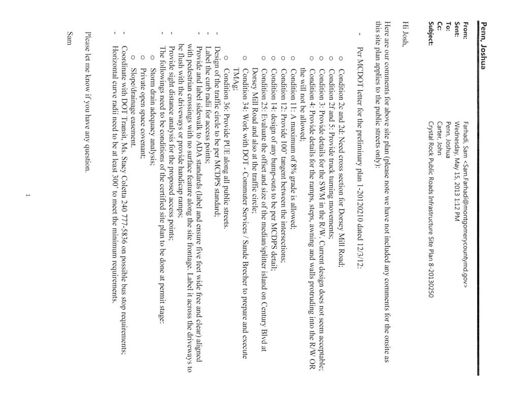
41 41 ATTACHMENT B
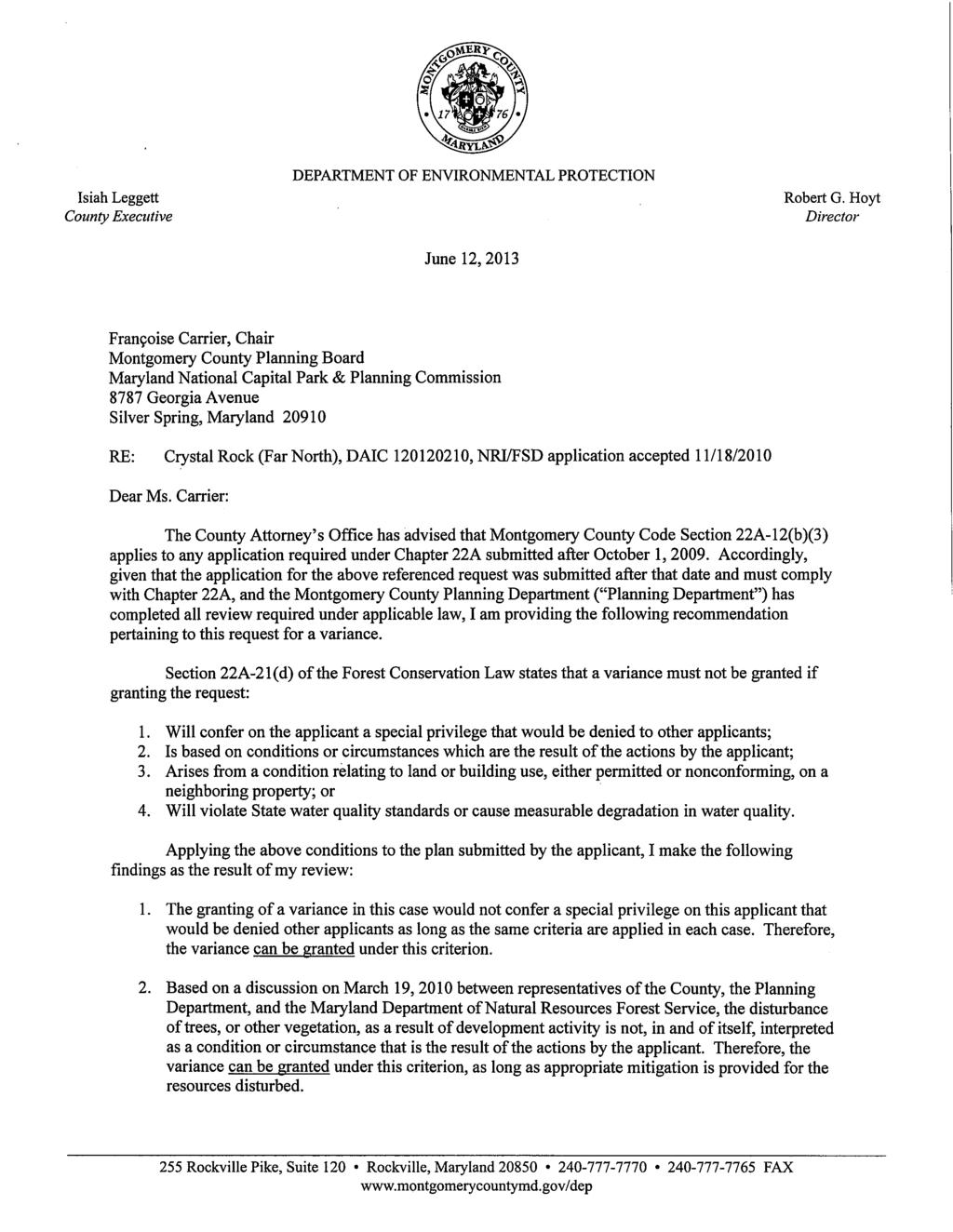
42 42 ATTACHMENT C
43 43
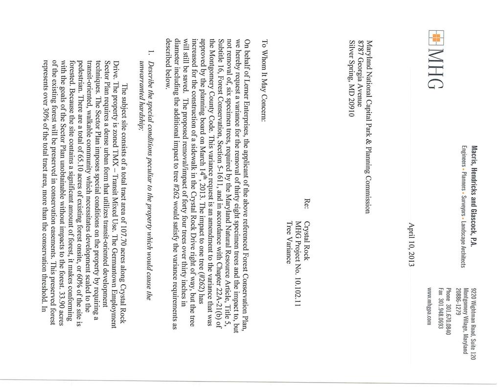
44 44
45 45
46 46
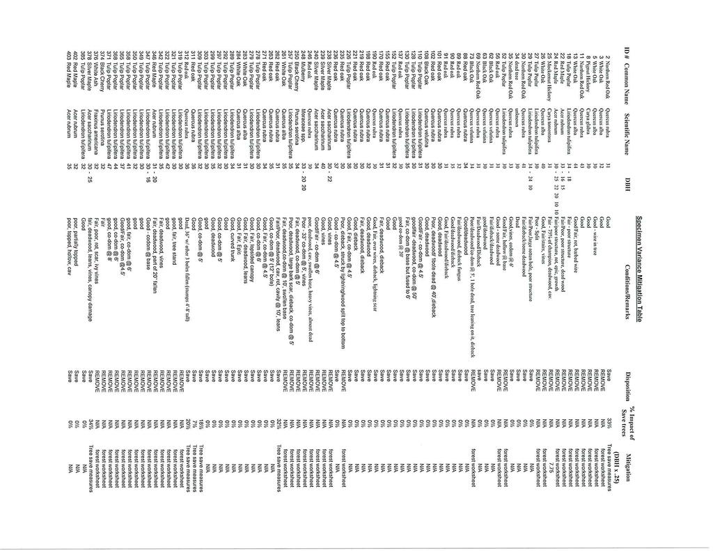
47 47
MONTGOMERY COUNTY PLANNING DEPARTMENT THE MARYLAND-NATIONAL CAPITAL PARK AND PLANNING COMMISSION
 MONTGOMERY COUNTY PLANNING DEPARTMENT THE MARYLAND-NATIONAL CAPITAL PARK AND PLANNING COMMISSION MCPB Item No.: 11 Date: 06-28-18 Black Hill Infrastructure Site Plan Amendment No. 82013025C Benjamin Berbert,
MONTGOMERY COUNTY PLANNING DEPARTMENT THE MARYLAND-NATIONAL CAPITAL PARK AND PLANNING COMMISSION
 MONTGOMERY COUNTY PLANNING DEPARTMENT THE MARYLAND-NATIONAL CAPITAL PARK AND PLANNING COMMISSION MCPB Item No. Date: 05-22-14 Consent Item - Park Potomac: Site Plan Amendment No. 82004015K MCS. Molline
MONTGOMERY COUNTY PLANNING DEPARTMENT THE MARYLAND NATIONAL CAPITAL PARK AND PLANNING COMMISSION
 MONTGOMERY COUNTY PLANNING DEPARTMENT THE MARYLAND NATIONAL CAPITAL PARK AND PLANNING COMMISSION MCPB Date: 03-10-16 Black Hill: Project Plan No. 92012004A, Preliminary Plan No. 12012021A, Site Plan No.
MONTGOMERY COUNTY PLANNING DEPARTMENT THE MARYLAND-NATIONAL CAPITAL PARK AND PLANNING COMMISSION
 MONTGOMERY COUNTY PLANNING DEPARTMENT THE MARYLAND-NATIONAL CAPITAL PARK AND PLANNING COMMISSION MCPB Item No. Date: 06-12-14 King of the Nations Christian Fellowship Church: Limited Site Plan Amendment
MONTGOMERY COUNTY PLANNING DEPARTMENT
 MONTGOMERY COUNTY PLANNING DEPARTMENT THE MARYLAND-NATIONAL CAPITAL PARK AND PLANNING COMMISSION MCPB Item No.: Date: 5-03-18 Pike and Rose, Phase I: Site Plan Amendment No. 82012002D Rhoda Hersson-Ringskog,
MONTGOMERY COUNTY PLANNING DEPARTMENT THE MARYLAND-NATIONAL CAPITAL PARK AND PLANNING COMMISSION
 MONTGOMERY COUNTY PLANNING DEPARTMENT THE MARYLAND-NATIONAL CAPITAL PARK AND PLANNING COMMISSION MCPB Item No. Date: 3.10.2016 Site Plan 820160040 Nora School Parker Smith, Planning Technician, Area 1,
MONTGOMERY COUNTY PLANNING DEPARTMENT THE MARYLAND-NATIONAL CAPITAL PARK AND PLANNING COMMISSION MCPB Item No.: 13 Date: 07/19/18
 MONTGOMERY COUNTY PLANNING DEPARTMENT THE MARYLAND-NATIONAL CAPITAL PARK AND PLANNING COMMISSION MCPB Item No.: 13 Date: 07/19/18 Black Hill / ViaSat: Project Plan No. 92012004B, Preliminary Plan No. 12012021B,
MONTGOMERY COUNTY PLANNING DEPARTMENT THE MARYLAND-NATIONAL CAPITAL PARK AND PLANNING COMMISSION
 MONTGOMERY COUNTY PLANNING DEPARTMENT THE MARYLAND-NATIONAL CAPITAL PARK AND PLANNING COMMISSION MCPB Item No. Date: 12-10-15 Leisure World Clubhouse II Addition Fitness Center, Limited Site Plan Amendment
MONTGOMERY COUNTY PLANNING DEPARTMENT THE MARYLAND-NATIONAL CAPITAL PARK AND PLANNING COMMISSION
 MONTGOMERY COUNTY PLANNING DEPARTMENT THE MARYLAND-NATIONAL CAPITAL PARK AND PLANNING COMMISSION MCPB Item No. Date: 1/15/2015 Bethesda North Marriott Hotel and Conference Center: Limited Site Plan Amendment
MONTGOMERY COUNTY PLANNING DEPARTMENT THE MARYLAND-NATIONAL CAPITAL PARK AND PLANNING COMMISSION
 MONTGOMERY COUNTY PLANNING DEPARTMENT THE MARYLAND-NATIONAL CAPITAL PARK AND PLANNING COMMISSION MCPB Item No. Date: 1/26/12 Hanover Shady Grove, Sketch Plan 320120020 Joshua Sloan, Coordinator, Joshua.Sloan@MontgomeryPlanning.org,
The subject site plan amendment proposes the following revisions to the approved site plan:
 PROPOSED AMENDMENT The subject site plan amendment proposes the following revisions to the approved site plan: 1. The building footprint was modified to accommodate the revised architectural design. 2.
Clarksburg Square Road Extension
 Clarksburg Square Road Extension Preliminary Plan No. 120140060 Site Plan No. 820140050 Site Plan Amendment No. 82007022C (Clarksburg Town Center) Clarksburg SPA Water Quality Plan Mandatory Referral MR2015008
Town Center. Block 5 Existing multifamily residential units are expected to remain.
 Area Guidelines Germantown s districts should be developed as distinct communities with unique features that are supported through the guidelines. The guidelines not only help distinguish these districts
TABLE OF CONTENTS SITE DESCRIPTION 3 Vicinity 3 Site Analysis 4. PROJECT DESCRIPTION 5 Proposal 5
 TABLE OF CONTENTS SITE DESCRIPTION 3 Vicinity 3 Site Analysis 4 PROJECT DESCRIPTION 5 Proposal 5 PROJECT ANALYSIS 6 Master Plan 6 Transportation & Circulation 6 Environment 7 Development Standards 8 Community
MONTGOMERY COUNTY PLANNING DEPARTMENT
 MONTGOMERY COUNTY PLANNING DEPARTMENT THE MARYLAND-NATIONAL CAPITAL PARK AND PLANNING COMMISSION Ashburton Elementary School Addition, Mandatory Referral, MR2018009 MCPB Item No. Date: 02-15-18 Troy Leftwich,
MONTGOMERY COUNTY PLANNING DEPARTMENT THE MARYLAND-NATIONAL CAPITAL PARK AND PLANNING COMMISSION
 MONTGOMERY COUNTY PLANNING DEPARTMENT THE MARYLAND-NATIONAL CAPITAL PARK AND PLANNING COMMISSION MCPB Item No. Date10/25/12 Sketch Plan No. 32012004, White Flint Mall Redevelopment Nkosi Yearwood, Senior
MONTGOMERY COUNTY PLANNING DEPARTMENT THE MARYLAND-NATIONAL CAPITAL PARK AND PLANNING COMMISSION
 MONTGOMERY COUNTY PLANNING DEPARTMENT THE MARYLAND-NATIONAL CAPITAL PARK AND PLANNING COMMISSION MCPB Item No. Date: 05/12/2016 North Bethesda Conference Center Parking Structure, Mandatory Referral No.
Westwood Shopping Center Sketch Plan, Plan # February 23, 2017 Item # 9
 Westwood Shopping Center Sketch Plan, Plan # 320170010 February 23, 2017 Item # 9 Westwood II Site 64,111 s.f. Manor Care site: vacant two story building HOC-Westwood Towers, 15 story tower To be considered
MONTGOMERY COUNTY PLANNING DEPARTMENT Newell Street. Site Plan Item #2. Maryland-National Capital Park and Planning Commission
 8001 Newell Street Site Plan 820140020 Item #2 December 19, 2013 Redlined Conditions 1. The Applicant must comply with the conditions of approval for Project Plan 920130020 in MCPB Resolution No. 13-74.
Seneca Meadows. Block 4 Locate office, technology, and medical development adjacent to I Screen views of garage structures from I-270.
 Seneca Meadows Seneca Meadows has an industrial park in its southern end and a mixed-use employment area planned for the north end. The district benefits from extensive I-270 visibility, stream valley
MONTGOMERY COUNTY PLANNING DEPARTMENT THE MARYLAND-NATIONAL CAPITAL PARK AND PLANNING COMMISSION
 MONTGOMERY COUNTY PLANNING DEPARTMENT THE MARYLAND-NATIONAL CAPITAL PARK AND PLANNING COMMISSION MCPB Item No. Date: 9-4-13 Limited Site Plan Amendment No. 81994026B, Darcars at Montgomery Industrial Park,
Gold Line Bus Rapid Transit Transit Oriented Development (BRTOD) Helmo Station Area Plan
 Helmo Station Area Plan") Appendix F Gold Line Bus Rapid Transit Transit Oriented Development (BRTOD) Helmo Station Area Plan Introduction and Purpose of the Plan The Gold Line Bus Rapid Transit facility is an eleven-mile dedicated
Appendix F Gold Line Bus Rapid Transit Transit Oriented Development (BRTOD) Helmo Station Area Plan Introduction and Purpose of the Plan The Gold Line Bus Rapid Transit facility is an eleven-mile dedicated
REQUEST Current Zoning: O-15(CD) (office) Proposed Zoning: TOD-M(CD) (transit oriented development mixed-use, conditional)
 (office) Proposed Zoning: TOD-M(CD) (transit oriented development mixed-use, conditional)") Rezoning Petition 2016-117 Zoning Committee Recommendation January 4, 2017 REQUEST Current Zoning: O-15(CD) (office) Proposed Zoning: TOD-M(CD) (transit oriented development mixed-use, conditional) LOCATION
Rezoning Petition 2016-117 Zoning Committee Recommendation January 4, 2017 REQUEST Current Zoning: O-15(CD) (office) Proposed Zoning: TOD-M(CD) (transit oriented development mixed-use, conditional) LOCATION
MONTGOMERY COUNTY PLANNING DEPARTMENT THE MARYLAND-NATIONAL CAPITAL PARK AND PLANNING COMMISSION
 MONTGOMERY COUNTY PLANNING DEPARTMENT THE MARYLAND-NATIONAL CAPITAL PARK AND PLANNING COMMISSION MCPB Item No. 8 Date: 12-15-16 Montgomery Village Center Sketch Plan No. 320170020 TL Troy Leftwich, Senior
MONTGOMERY COUNTY PLANNING DEPARTMENT
 MONTGOMERY COUNTY PLANNING DEPARTMENT THE MARYLAND-NATIONAL CAPITAL PARK AND PLANNING COMMISSION MCPB Item No. Date: 12/20/2018 Nucci Subdivision, Preliminary Plan No. 120160170 MF Marco Fuster, Planner
COUNTY COUNCIL OF PRINCE GEORGE'S COUNTY, MARYLAND SITTING AS THE DISTRICT COUNCIL 2010 Legislative Session. Council Members Dernoga and Olson
 DR- COUNTY COUNCIL OF PRINCE GEORGE'S COUNTY, MARYLAND SITTING AS THE DISTRICT COUNCIL 00 Legislative Session Bill No. CB--00 Chapter No. Proposed and Presented by Introduced by Co-Sponsors The Chairman
MONTGOMERY COUNTY PLANNING DEPARTMENT
 OCT MONTGOMERY COUNTY PLANNING DEPARTMENT THE MARYLAND-NATIONAL CAPITAL PARK AND PLANNING COMMISSION 2 1 2009 MCPB No. 09-124 Project Name: Date of Hearing: September 17,2009 MONTGOMERY COUNTY PLANNING
MONTGOMERY COUNTY PLANNING DEPARTMENT THE MARYLAND-NATIONAL CAPITAL PARK AND PLANNING COMMISSION
 MONTGOMERY COUNTY PLANNING DEPARTMENT THE MARYLAND-NATIONAL CAPITAL PARK AND PLANNING COMMISSION William H. Farquhar Middle School Modernization MCPB Item No. 10 Date: 09-18-2014 Description Summary Fred
WHEREAS, after consideration of the evidence presented at the public hearing on January 14, 2010, the Prince George's County Planning Board finds:
 R E S O L U T I O N WHEREAS, the Prince George s County Planning Board has reviewed DDS-600 requesting a departure for the location of two loading spaces without driveway access along Toledo Terrace in
Germantown Forward Status Report to the Planning Board M NCPPC
 Germantown Forward Status Report to the Planning Board Germantown Forward March 27, 2008 What s new? CCT alignment Capital Improvement Program Agency partners Water quality conditions Sustainability Design
I. Introduction. Prior Approvals
 Statement of Justification First National Bank 19790 Crystal Rock Drive, Germantown, Maryland Application for Site Plan and Limited Preliminary Plan Amendment I. Introduction DPH Architecture, for First
Note: Staff reports can be accessed at Zone: I-3. Tier:
 The Maryland-National Capital Park and Planning Commission Prince George s County Planning Department Development Review Division 301-952-3530 Note: Staff reports can be accessed at www.mncppc.org/pgco/planning/plan.htm.
MONTGOMERY COUNTY PLANNING DEPARTMENT THE MARYLAND-NATIONAL CAPITAL PARK AND PLANNING COMMISSION
 MONTGOMERY COUNTY PLANNING DEPARTMENT THE MARYLAND-NATIONAL CAPITAL PARK AND PLANNING COMMISSION Staff Report: Sketch Plan #320110010, Mid-Pike Plaza ITEM #: MCPB HEARING DATE: January 20, 2011 REPORT
MONTGOMERY COUNTY PLANNING DEPARTMENT THE MARYLAND-NATIONAL CAPITAL PARK AND PLANNING COMMISSION
 MONTGOMERY COUNTY PLANNING DEPARTMENT THE MARYLAND-NATIONAL CAPITAL PARK AND PLANNING COMMISSION MCPB Item No.: 2 Date: 12-19-13 Site Plan 820140020, 8001 Newell Street Neil Braunstein, AICP, Area 1, neil.braunstein@montgomeryplanning.org,
STATEMENT OF JUSTIFICATION CLARKSBURG PREMIUM OUTLETS AT CABIN BRANCH NORTH DISTRICT, PHASE
 STATEMENT OF JUSTIFICATION CLARKSBURG PREMIUM OUTLETS AT CABIN BRANCH NORTH DISTRICT, PHASE 1 Southwest Corner of Clarksburg Road and Interstate-270 Clarksburg, Maryland Application for Site Plan #820140160
MONTGOMERY COUNTY PLANNING DEPARTMENT THE MARYLAND-NATIONAL CAPITAL PARK AND PLANNING COMMISSION
 MONTGOMERY COUNTY PLANNING DEPARTMENT THE MARYLAND-NATIONAL CAPITAL PARK AND PLANNING COMMISSION MCPB Item No. Date: 07-26-12 Limited Site Plan Amendment: 82004015I Park Potomac M.C.S. Molline Smith, Senior
MONTGOMERY COUNTY PLANNING DEPARTMENT THE MARYLAND NATIONAL CAPITAL PARK AND PLANNING COMMISSION
 MONTGOMERY COUNTY PLANNING DEPARTMENT THE MARYLAND NATIONAL CAPITAL PARK AND PLANNING COMMISSION MCPB Item No. Date: 5.3.18 8000 Wisconsin Avenue Sketch Plan No. 320180120 Matthew Folden, Planner Coordinator,
MONTGOMERY COUNTY PLANNING DEPARTMENT THE MARYLAND-NATIONAL CAPITAL PARK AND PLANNING COMMISSION
 MONTGOMERY COUNTY PLANNING DEPARTMENT THE MARYLAND-NATIONAL CAPITAL PARK AND PLANNING COMMISSION The Goddard School in North Bethesda Preliminary Plan Amendment 11996015B and Site Plan Amendment 82006005A
R E S O L U T I O N. Single-Family Residence/ Church. 2,488 sq. ft. 2,488 sq. ft. Area Parking Required: Church
 R E S O L U T I O N WHEREAS, the Prince George s County Planning Board is charged with the approval of Detailed Site Plans pursuant to Part 3, Division 9 of the Zoning Ordinance of the Prince George s
MONTGOMERY COUNTY PLANNING DEPARTMENT THE MARYLAND NATIONAL CAPITAL PARK AND PLANNING COMMISSION
 MONTGOMERY COUNTY PLANNING DEPARTMENT THE MARYLAND NATIONAL CAPITAL PARK AND PLANNING COMMISSION MCPB Item No. 3 Date: 1.5.17 7272 Wisconsin Avenue: Sketch Plan Amendment No. 32016004A, Preliminary Plan
The Development Review Process. Presentation to the GSSC IAC
 The Development Review Process Presentation to the GSSC IAC July 19, 2011 Regulatory Processes in the Planning Department Natural Resource Inventory/Forest Stand Delineation Zoning (Development Plan) Special
MONTGOMERY COUNTY PLANNING BOARD
 NOV MONTGOMERY COUNTY PLANNING BOARD "' HI MARYLAND-NATIONAL CAPITAL PARK AND PLANNING COMMISSION 1 7 2011 MCPB No. 09-135 Project Name: Date of Hearing: October 22, 2009 MONTGOMERY COUNTY PLANNING BOARD
MONTGOMERY COUNTY PLANNING DEPARTMENT THE MARYLAND-NATIONAL CAPITAL PARK AND PLANNING COMMISSION
 MONTGOMERY COUNTY PLANNING DEPARTMENT THE MARYLAND-NATIONAL CAPITAL PARK AND PLANNING COMMISSION MCPB Item No. Date: 10.25.18 Artery Plaza: Site Plan Amendment 81984002E SD Stephanie Dickel, Planner Coordinator,
MONTGOMERY COUNTY PLANNING DEPARTMENT THE MARYLAND-NATIONAL CAPITAL PARK AND PLANNING COMMISSION
 MONTGOMERY COUNTY PLANNING DEPARTMENT THE MARYLAND-NATIONAL CAPITAL PARK AND PLANNING COMMISSION MCPB Item No. 3 Date: 02-28-13 8415 Fenton Street, Preliminary Plan 120120130, Site Plan 820130050 John
COUNTY COUNCIL OF PRINCE GEORGE'S COUNTY, MARYLAND, SITTING AS THE DISTRICT COUNCIL ORDER AFFIRMING PLANNING BOARD DECISION, WITH AMENDED CONDITIONS
 Case No. Applicant: Dawn Limited Partnership COUNTY COUNCIL OF PRINCE GEORGE'S COUNTY, MARYLAND, SITTING AS THE DISTRICT COUNCIL ORDER AFFIRMING PLANNING BOARD DECISION, WITH AMENDED CONDITIONS IT IS HEREBY
Clarksburg Master Plan Concept and the Clarksburg Town Center. Planning Regulating Building
 Master Plan Concept and the Town Center Planning Regulating Building Overview with CTC PHED T&E Dec 12, 2011 outline Location Master Plan Concept Staging Approved Preliminary Plans Infrastructure Town
COMMUNITY DESIGN. GOAL: Create livable and attractive communities. Intent
 COMMUNITY DESIGN Intent An attractive, well-designed County will attract quality development, instill civic pride, improve the visual character of the community, and create a strong, positive image for
MONTGOMERY COUNTY PLANNING DEPARTMENT
 MONTGOMERY COUNTY PLANNING DEPARTMENT THE MARYLAND-NATIONAL CAPITAL PARK AND PLANNING COMMISSION MCPB Item No. Date: 04/05/2018 850 Sligo Avenue Sketch Plan No. 320180090 Neil Sullivan, Planner Coordinator,
DRAFT. October Wheaton. Design Guidelines
 October 2011 DRAFT Wheaton Design Guidelines 2 Draft - Design Guidelines - Wheaton Sector Plan Contents 04 Section 1: Introduction 06 Section 2: Context 08 Section 3: Design Guidelines 09 Goal 1: Create
Asbury Chapel Subdivision Sketch Plan
 Asbury Chapel Subdivision Sketch Plan PART 1: PROJECT SUMMARY Applicant: NVR Inc. Project Size: +/- 76.13 acres Parcel Numbers: 02101112,02116101,02116112, 02116113 Current Zoning: Transitional Residential
MONTGOMERY COUNTY PLANNING DEPARTMENT THE MARYLAND-NATIONAL CAPITAL PARK AND PLANNING COMMISSION
 MONTGOMERY COUNTY PLANNING DEPARTMENT THE MARYLAND-NATIONAL CAPITAL PARK AND PLANNING COMMISSION Gables White Flint, Preliminary Plan No. 120150010 and Site Plan No. 820150010 MCPB Item No. Date: 4/30/2015
MONTGOMERY COUNTY PLANNING DEPARTMENT THE MARYLAND-NATIONAL CAPITAL PARK AND PLANNING COMMISSION
 MONTGOMERY COUNTY PLANNING DEPARTMENT THE MARYLAND-NATIONAL CAPITAL PARK AND PLANNING COMMISSION Montgomery Auto Sales Park: Preliminary Plan No. 11985027A, Site Plan No. 820140130 and Site Plan No. 820140140
Ripley East. Sketch Plan Amendment No A Preliminary Plan No Site Plan No MONTGOMERY COUNTY PLANNING DEPARTMENT
 Ripley East Sketch Plan Amendment No. 32015001A Preliminary Plan No. 120150220 Site Plan No. 820150130 Planning Board Hearing Date: December 3, 2015 Site Vicinity and Site Description Silver Spring Transit
MONTGOMERY COUNTY PLANNING DEPARTMENT
 MONTGOMERY COUNTY PLANNING DEPARTMENT THE MARYLAND-NATIONAL CAPITAL PARK AND PLANNING COMMISSION MCPB Item No.: 11 Date: 7-20-17 Burtonsville McDonalds: Site Plan No. 820150020 Jonathan Casey, Senior Planner,
ARTICLE 6: Special and Planned Development Districts
 ARTICLE 6: Special and Planned Development Districts 6-10 Traditional Neighborhood Development (TND) District 6-10.10 Purpose and Intent The Traditional Neighborhood Development (TND) District provides
MONTGOMERY COUNTY PLANNING DEPARTMENT THE MARYLAND-NATIONAL CAPITAL PARK AND PLANNING COMMISSION
 MONTGOMERY COUNTY PLANNING DEPARTMENT THE MARYLAND-NATIONAL CAPITAL PARK AND PLANNING COMMISSION Preliminary Plan 120120220 & Site Plan 820120140, 7001 Arlington Road MCPB Item No. 8 Date: 11-1-12 Erin
1. Request: The subject application is for approval of a gymnasium addition to an existing private school and church.
 R E S O L U T I O N WHEREAS, the Prince George's County Planning Board is charged with the approval of Detailed Site Plans pursuant to Part 3, Division 9 of the Zoning Ordinance of the Prince George's
MONTGOMERY COUNTY PLANNING DEPARTMENT THE MARYLAND-NATIONAL CAPITAL PARK AND PLANNING COMMISSION
 MONTGOMERY COUNTY PLANNING DEPARTMENT THE MARYLAND-NATIONAL CAPITAL PARK AND PLANNING COMMISSION MCPB Item No. 3 4/3/14 4990 Fairmont Avenue, Site Plan 820140060 Erin Banks, AICP, Senior Planner, Area
MONTGOMERY COUNTY PLANNING DEPARTMENT THE MARYLAND-NATIONAL CAPITAL PARK AND PLANNING COMMISSION
 MONTGOMERY COUNTY PLANNING DEPARTMENT THE MARYLAND-NATIONAL CAPITAL PARK AND PLANNING COMMISSION MCPB Item No. Date: 07-17-2014 Rock Spring Park, Preliminary Plan Amendment 11998093B and Site Plan Amendment,
MONTGOMERY COUNTY PLANNING DEPARTMENT THE MARYLAND-NATIONAL CAPITAL PARK AND PLANNING COMMISSION
 MONTGOMERY COUNTY PLANNING DEPARTMENT THE MARYLAND-NATIONAL CAPITAL PARK AND PLANNING COMMISSION MCPB Item Date: 09/08/16 The Collection (Formerly Chevy Chase Center): Site Plan Amendment No. 82001013C,
Approved: CITY OF ARDEN HILLS, MINNESOTA PLANNING COMMISSION WEDNESDAY, AUGUST 5, :30 P.M. - ARDEN HILLS CITY HALL
 Approved: CITY OF ARDEN HILLS, MINNESOTA PLANNING COMMISSION WEDNESDAY, AUGUST 5, 2015 6:30 P.M. - ARDEN HILLS CITY HALL PLANNING CASES A. Planning Case 15-016; Final Planned Unit Development Arden Plaza;
MONTGOMERY COUNTY PLANNING DEPARTMENT THE MARYLAND NATIONAL CAPITAL PARK AND PLANNING COMMISSION
 MONTGOMERY COUNTY PLANNING DEPARTMENT THE MARYLAND NATIONAL CAPITAL PARK AND PLANNING COMMISSION MCPB Item No. 8 Date: 3.30.2017 Project Name: Lot 31/31A Bethesda, Site Plan Amendment, No. 82007018C Elza
MONTGOMERY COUNTY PLANNING DEPARTMENT THE MARYLAND-NATIONAL CAPITAL PARK AND PLANNING COMMISSION
 MONTGOMERY COUNTY PLANNING DEPARTMENT THE MARYLAND-NATIONAL CAPITAL PARK AND PLANNING COMMISSION MCPB Item No. 6 Date: 5-9-13 Site Plan No. 820130090, West Chevy Chase Heights Erin Grayson, Senior Planner,
MONTGOMERY COUNTY PLANNING DEPARTMENT THE MARYLAND-NATIONAL CAPITAL PARK AND PLANNING COMMISSION
 MONTGOMERY COUNTY PLANNING DEPARTMENT THE MARYLAND-NATIONAL CAPITAL PARK AND PLANNING COMMISSION Ashton Market: Preliminary Plan No. 120180180 and Site Plan No. 820180160 Jonathan Casey, Senior Planner,
The Maryland-National Capital Park and Planning Commission Prince George's County Planning Department Development Review Division
 The Maryland-National Capital Park and Planning Commission Prince George's County Planning Department Development Review Division 301-952-3530 Note: Staff reports can be accessed at www.mncppc.org/pgco/planning/plan.htm.
Location and Field Inspection: History: Master Plan Recommendation:
 R E S O L U T I O N WHEREAS, the Prince George s County Planning Board has reviewed Special Permit Application No. SP-130008, Sudsville Laundry, requesting a special permit to construct an addition and
MONTGOMERY COUNTY PLANNING DEPARTMENT
 MONTGOMERY COUNTY PLANNING DEPARTMENT THE MARYLAND-NATIONAL CAPITAL PARK AND PLANNING COMMISSION North Bethesda Town Center Parcel G Site Plan No. 820180010 MCPB Item No.: Date: 01-25-18 Atul Sharma, Planner
MONTGOMERY COUNTY PLANNING DEPARTMENT
 MONTGOMERY COUNTY PLANNING DEPARTMENT THE MARYLAND-NATIONAL CAPITAL PARK AND PLANNING COMMISSION MCPB Item No. 4 Date: 12-15-16 CVS Derwood: Site Plan No. 820160150 Calvin Nelson, Jr., Planner Coordinator,
PLANNED UNIT DEVELOPMENT Date: April 5, 2018
 PLANNED UNIT DEVELOPMENT Date: April 5, 2018 DEVELOPMENT NAME SUBDIVISION NAME LOCATION Robert Myers Robert Myers 2955 and 2989 Dauphin Street (Southeast corner of Dauphin Street and Sage Avenue) CITY
CHESAPEAKE LANDSCAPE ORDINANCE
 CHESAPEAKE LANDSCAPE ORDINANCE CONSERVATION PRESERVATION CZO 19-600 Effective October 16, 2008 BUFFER YARD C PARKING LOT REFORESTATION YEAR 1 REFORESTATION YEAR 4 BUFFER YARD F CBPA REFORESTATION Page
PLANNED UNIT DEVELOPMENT & SUBDIVISION STAFF REPORT Date: May 18, 2017
 & PUD-0000102-2017 PLANNED UNIT DEVELOPMENT & SUBDIVISION STAFF REPORT Date: May 18, 2017 NAME SUBDIVISION NAME Dauphin Creek Estates Subdivision Dauphin Creek Estates Subdivision LOCATION CITY COUNCIL
MONTGOMERY COUNTY PLANNING DEPARTMENT THE MARYLAND-NATIONAL CAPITAL PARK AND PLANNING COMMISSION
 MONTGOMERY COUNTY PLANNING DEPARTMENT THE MARYLAND-NATIONAL CAPITAL PARK AND PLANNING COMMISSION MCPB Item No. Date: 9/22/16 Ripley II: Sketch Plan Amendment No. 32015003A, Preliminary Plan No. 120160190,
S C O P E O F W O R K A P R I L
 white flint 2 sector plan S C O P E O F W O R K A P R I L 2 0 1 2 MONTGOMERY COUNTY PLANNING DEPARTMENT M-NCPPC MontgomeryPlanning.org 1 white flint 2 sector plan Scope of Work abstract This scope of work
1. Request: The subject application requests the construction of a single-family home in the R-R Zone.
 R E S O L U T I O N WHEREAS, the Prince George's County Planning Board is charged with the approval of Detailed Site Plans pursuant to Part 3, Division 9 of the Zoning Ordinance of the Prince George's
Project Name: MELWOOD HOTEL. Date Accepted: 1/12/04. Waived. Planning Board Action Limit: Plan Acreage: 1.7 Zone: Dwelling Units:
 The Maryland-National Capital Park and Planning Commission Prince George's County Planning Department Development Review Division 301-952-3530 Note: Staff reports can be accessed at www.mncppc.org/pgco/planning/plan.htm.
The transportation system in a community is an
 7 TRANSPORTATION The transportation system in a community is an important factor contributing to the quality of life of the residents. Without a sound transportation system to bring both goods and patrons
MONTGOMERY COUNTY PLANNING DEPARTMENT THE MARYLAND-NATIONAL CAPITAL PARK AND PLANNING COMMISSION
 MONTGOMERY COUNTY PLANNING DEPARTMENT THE MARYLAND-NATIONAL CAPITAL PARK AND PLANNING COMMISSION MCPB Item No.: Consent Date: 12/20/18 Mt. Prospect: Site Plan Amendment No. 82017016A Benjamin Berbert,
ARTICLE 17 SITE PLAN REVIEW
 ARTICLE 17 SITE PLAN REVIEW 17.01 INTENT AND PURPOSE The intent of this section is to provide for consultation and cooperation between the applicant and the township planning commission so that the applicant
MONTGOMERY COUNTY PLANNING DEPARTMENT
 MONTGOMERY COUNTY PLANNING DEPARTMENT THE MARYLAND-NATIONAL CAPITAL PARK AND PLANNING COMMISSION Ourisman Ford at Montgomery Mall, Sketch Plan No. 320170100 MCPB Item No. Date: 11-30-17 LS Lori Shirley,
MONTGOMERY COUNTY PLANNING DEPARTMENT THE MARYLAND-NATIONAL CAPITAL PARK AND PLANNING COMMISSION
 MONTGOMERY COUNTY PLANNING DEPARTMENT THE MARYLAND-NATIONAL CAPITAL PARK AND PLANNING COMMISSION MCPB Item No. Date: 7/30/2015 Pooks Hill Sketch Plan No. 320150060 Kathleen A. Reilly, AICP Planner Coordinator,
MONTGOMERY COUNTY PLANNING DEPARTMENT
 MONTGOMERY COUNTY PLANNING DEPARTMENT THE MARYLAND-NATIONAL CAPITAL PARK AND PLANNING COMMISSION 6000 Executive Boulevard, Sketch Plan No. 320180140 MCPB Item No. Date: 06/21/2018 Emily Tettelbaum, Senior
12 January 12, 2011 Public Hearing APPLICANT: TAILWIND DEVELOPMENT GROUP,LLC PROPERTY OWNER: CITY OF VIRGINIA BEACH
 12 January 12, 2011 Public Hearing APPLICANT: TAILWIND DEVELOPMENT GROUP,LLC PROPERTY OWNER: CITY OF VIRGINIA BEACH STAFF PLANNER: Faith Christie REQUEST: Conditional Change of Zoning (from PD-H1 Planned
Baumgarten MPUD. Exhibit 3 Evaluation Criteria
 Pursuant to LDC subsections 10.02.13 B, 10.02.08 F and Chapter 3 G. of the Administrative Code, staff s analysis and recommendation to the Planning Commission, and the Planning Commission s recommendation
ATTACHMENT A. SILVERDALE DESIGN STANDARDS Amendments to the Waaga Way Town Center Chapter
 ATTACHMENT A SILVERDALE DESIGN STANDARDS Amendments to the Waaga Way Town Center Chapter Chapter 10. Waaga Way Town Center 10.1 Physical Identity Elements & Opportunities The Waaga Way Town Center includes
R E S O L U T I O N. 2. Development Data Summary:
 R E S O L U T I O N WHEREAS, the Prince George s County Planning Board has reviewed Departure from Design Standards DDS-631 requesting a departure to allow the loading space and the driveway to the loading
MONTGOMERY COUNTY PLANNING DEPARTMENT THE MARYLAND-NATIONAL CAPITAL PARK AND PLANNING COMMISSION
 MONTGOMERY COUNTY PLANNING DEPARTMENT THE MARYLAND-NATIONAL CAPITAL PARK AND PLANNING COMMISSION MCPB Item No.: 9 Date: 07-20-17 Topgolf - Germantown: Preliminary Plan Amendment No. 12007065B and Site
Sketch Plan. MNCPPC Plan No: A
 General Notes 1. The Sketch Plan drawings are conceptual only and represent proposed development in an illustrative manner. Final building locations, dimensions, heights, uses and development standards
PART 1: PROJECT SUMMARY. The application is Attachment A. The site plan is Attachment B.
 Belleterre Subdivision Sketch Plan Town Board 8.7.17 Belleterre Subdivision Sketch Plan PART 1: PROJECT SUMMARY Applicant: Bowman Development Project Size: +/- 20.85 acres Parcel Number: 01115104 and 01115121
Planning Board Briefing
 Planning Board Briefing Why Now? The Sector Plan Implementation Chapter States: Before Stage 1 begins, the following must occur: Approval of the Sectional Map Amendment. Approval of the Greater Lyttonsville
MONTGOMERY COUNTY PLANNING DEPARTMENT THE MARYLAND-NATIONAL CAPITAL PARK AND PLANNING COMMISSION
 MONTGOMERY COUNTY PLANNING DEPARTMENT THE MARYLAND-NATIONAL CAPITAL PARK AND PLANNING COMMISSION MCPB Item No. Date: 7/26/12 Camden Shady Grove (Danac Stiles), Sketch Plan 320120050 Joshua Sloan, Planner
Chesapeake Bay Critical Area Conservation Plan
 The Maryland-National Capital Park and Planning Commission Prince George s County Planning Department Development Review Division 301-952-3530 Note: Staff reports can be accessed at www.mncppc.org/pgco/planning/plan.htm.
At first Work Session on October 22, At second Work Session on November 19, At third Work Session on December 3, 2015
 At first Work Session on October 22, 2015 Staff Reviewed Infrastructure: Transportation Capacity School Capacity Willett Branch Proposed Staging Language At second Work Session on November 19, 2015 Land
MONTGOMERY COUNTY PLANNING DEPARTMENT THE MARYLAND-NATIONAL CAPITAL PARK AND PLANNING COMMISSION
 MONTGOMERY COUNTY PLANNING DEPARTMENT THE MARYLAND-NATIONAL CAPITAL PARK AND PLANNING COMMISSION 8015 Old Georgetown Road, Preliminary Plan 120160220, Site Plan 820160090 MCPB Item No.: 8 Date: 11-03-16
Rezoning Petition Final Staff Analysis June 18, 2018
 Rezoning Petition 2018-028 Final Staff Analysis June 18, 2018 REQUEST Current Zoning: MX-1 LLWPA (mixed use district, Lower Lake Wylie Protected Area), R-3 LLWPA (single family residential, Lower Lake
MONTGOMERY COUNTY PLANNING DEPARTMENT THE MARYLAND-NATIONAL CAPITAL PARK AND PLANNING COMMISSION
 MONTGOMERY COUNTY PLANNING DEPARTMENT THE MARYLAND-NATIONAL CAPITAL PARK AND PLANNING COMMISSION MCPB Item No. Date: 04/24/2014 Sketch Plan No. 320140020, AVA Wheaton Michael Brown, Planner Coordinator,
Description of Preferred Alternative
 Chapter 2 Description of Preferred Alternative 2.1 Introduction This chapter of the programmatic Sammamish Town Center Sub-area Plan Final EIS provides a more detailed description of the Preferred Alternative
GENERAL INFORMATIONaaaaaaaaaaaaaaaaaaaaaaaaaaaaaaaa
 To: Planning and Zoning Commission From: City Staff Date: November 15, 2016 Re: Case #16026 Raymore Activity Center Site Plan GENERAL INFORMATIONaaaaaaaaaaaaaaaaaaaaaaaaaaaaaaaa Applicant/ Property Owner:
Mitchell Ranch South MPUD Application for Master Planned Unit Development Approval Project Narrative. Introduction
 Mitchell Ranch South MPUD Application for Master Planned Unit Development Approval Project Narrative Introduction Mitchell Ranch South is a proposed single family (detached) residential development on
COUNTY COUNCIL OF PRINCE GEORGE'S COUNTY, MARYLAND, SITTING AS THE DISTRICT COUNCIL ORDER AFFIRMING PLANNING BOARD DECISION (CORRECTED)
") Case No. Applicant: Lanham LLLP COUNTY COUNCIL OF PRINCE GEORGE'S COUNTY, MARYLAND, SITTING AS THE DISTRICT COUNCIL ORDER AFFIRMING PLANNING BOARD DECISION (CORRECTED) IT IS HEREBY ORDERED, after review
Case No. Applicant: Lanham LLLP COUNTY COUNCIL OF PRINCE GEORGE'S COUNTY, MARYLAND, SITTING AS THE DISTRICT COUNCIL ORDER AFFIRMING PLANNING BOARD DECISION (CORRECTED) IT IS HEREBY ORDERED, after review
Rezoning Petition Pre-Hearing Staff Analysis May 21, 2018
 Rezoning Petition 2018-028 Pre-Hearing Staff Analysis May 21, 2018 REQUEST Current Zoning: MX-1 LLWPA (mixed use district, Lower Lake Wylie Protected Area), R-3 LLWPA (single family residential, Lower