Route 7/15 Norwalk. Route 7/15 Norwalk Project Project Advisory Committee Meeting #5. Wednesday, November 14 th, Norwalk City Hall
|
|
|
- Rachel Shaw
- 5 years ago
- Views:
Transcription

1 Route 7/15 Norwalk Project Project Advisory Committee Meeting #5 Route 7/15 Norwalk PAC Meeting #5 November 14, 2018 Wednesday, November 14 th, Norwalk City Hall

2 Route 7/15 Norwalk - AGENDA Introductions Reviewing role of PAC SUMMARY OF 9/17 MEETINGS Purpose & Need Comments Summary of PAC #4 Landscape Workshop Alternative Review Alternatives Assessment Screening Next Steps/Questions
3 Route 7/15 Norwalk - Role of PAC To be instrumental in helping to craft a successful outcome, by: 1. Attend meetings, review material and educate yourself 2. Share viewpoints and ideas in project dialog 3. Link between the study team and the community - in both directions 4. Help reach consensus on project issues and alternates - honor differences in opinion and perspective 5. Support the consensus of the PAC

4 SUMMARY Route OF 7/159/17 Norwalk MEETINGS
5 Route 7/15 Norwalk - Purpose and Need Update Include landscape into integration goal Integrate the Project Roadways and Landscape with the Environment and Neighborhood context Move the footnote on landscape guidelines into full text as documented in the National Register of Historic Places nomination and State Scenic Road designation, following recommendations in the Merritt Parkway Guidelines for General Maintenance and Transportation Improvements, Merritt Parkway Landscape Master Plan, and Merritt Parkway Bridge Restoration Guide

6 Route 7/15 Norwalk - Needs & Deficiencies Report What we heard o Are you considering bicycle and pedestrian access at Grist Mill? o Why was there little reference to landscape deficiencies?


7 Route 7/15 Norwalk - Landscape Workshop What are the most appealing landscape/visual features within the project area? o Views of natural and built environments o Parkway feel for traffic calming o Plant variety/visibility
8 Route 7/15 Norwalk - Landscape Workshop What are the least appealing landscape/visual features within the project area? o Glover Avenue Apartments- New construction is too visible o Construction staging areas o Route 7 cloverleaf o Non-original bridges
9 Route 7/15 Norwalk - Landscape Workshop What is most important to you? Views Structures (Bridges) Maintenance Scale o Topography/landscape relationship o Hierarchy of plant materials to create intimate scale o Note contrast to I-95 Vegetation/Natural Resources
10 ALTERNATIVES Route 7/15 REVIEW Norwalk

 Multi-Level approach o Purpose and Need o Goals and Objectives o Other")
11 Route 7/15 Norwalk ALTERNATIVE SCREENING PURPOSE Allows for wide range of alternatives to be considered in a conceptual manner Move from many to a few alternatives to be fully evaluated within the NEPA/CEPA process (Environmental Assessment and Environmental Impact Evaluation) Multi-Level approach o Purpose and Need o Goals and Objectives o Other Considerations

12 LEVEL Route 1 SCREENING 7/15 Norwalk (PURPOSE AND NEED)
13 Route 7/15 Norwalk ALTERNATIVE SCREENING Project team took a step back to review all alternatives discussed in prior Environmental Assessment and stakeholder workshops Quick evaluation of traffic operations and key needs/goals Why o Do any have merit based on current purpose and need/goals o Confirm issues still exist
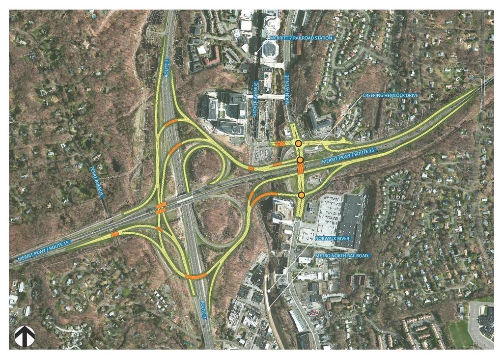
14 Route 7/15 Norwalk ALTERNATIVE SCREENING Level 1 (Purpose and Need) The key criteria to meet the Purpose & Need: Roadway System Linkages: Does the alternative provide complete connections between Route 7 and the Merritt Parkway? Mobility Improvements: Does the alternative provide connections between Main Avenue and Route7 and improve mobility for all users (motorists, pedestrians and bicyclists) at project interchange areas? Safety Considerations: Does the alternative improve safety in the vicinity of Interchange 39 and 40 on the Merritt Parkway?
15 Route 7/15 Norwalk PAC Meeting #5 November 14, 2018 ALTERNATIVE SCREENING Level 1 (Purpose and Need) Criteria Purpose & Need Roadway System Linkage Linkage between Route 7 and Merritt Parkway Mobility Improve mobility for all users (motorists, pedestrians, and cyclists) at project interchange areas* Safety Considerations Safety in vicinity of Interchanges 39 and 40** ALT. ALT. ALT. ALT. ALT. ALT. ALT. ALT. ALT. ALT. ALT. ALT. ALT. ALT. ALT. ALT. ALT. ALT. ALT. ALT. ALT. ALT. ALT. ALT. ALT. ALT. ALT. ALT. ALT. NO- BUILD 1 2 2A A A B 20B 21C 21D B Concept developed but refined as Alt 2A so discarded Concept developed but refined as Alt 12A so discarded Ability to Meet Purpose and Need Meets P&N Moderately Meets P&N Does Not Meet P&N More Analysis Needed Concept refined as Alt. 21D so discarded Concept developed at same time as Alt. 21C. Alt. 21C was previously determined to be the better version of this alternative. How was the Ability to Meet Purpose and Need Determined? Criteria Roadway System Linkage Linkage between Route 7 and Merritt Parkway Meets P&N ( g ) if Moderately Meets P&N ( g ) if Does Not Meet P&N ( g ) if Connections are made in all directions to/from Route 7 and Merritt Parkway N/A. Connections are not made in all directions to/from Route 7 and Merritt Parkway Mobility Improve mobility for all users (motorists, pedestrians, and cyclists) at project interchange areas* Safety Considerations Safety in vicinity of Interchanges 39 and 40** Vehicular connections are provided between Main Avenue and Route 7 and all connections are maintained between Merritt Parkway and Creeping Hemlock Drive. Local road network improvements are apparent. No apparent geometric deficiencies (e.g., inadequate distances, tight ramps) are identified. Vehicular connections are provided between Main Avenue and Route 7 but not all connections are maintained between Merritt Parkway and Creeping Hemlock Drive. Local road network improvements may or may not be apparent. Some apparent geometric deficiencies such as short weaving distances between ramps are maintained or adjacent on- and/or off-ramps are proposed Vehicular connections are not provided between Main Avenue and Route 7 and/or no connections are maintained between Merritt Parkway and Creeping Hemlock Drive. The local road network is not improved. Many apparent geometric deficiencies such as short weaving distances, inadequate acceleration/deceleration lanes, etc. are proposed or past assessments specifically denoted safety concerns.
16 Route 7/15 Norwalk ALTERNATIVE SCREENING Level 1 (Purpose and Need) Criteria Meets P&N ( ) if Roadway System Linkage Linkage between Route 7 and Merritt Parkway Mobility Improve mobility for all users (motorists, pedestrians, and cyclists) at project interchange areas* Safety Considerations Safety in vicinity of Interchanges 39 and 40** Connections are made in all directions to/from Route 7 and Merritt Parkway Vehicular connections are provided between Main Avenue and Route 7 and all connections are maintained between Merritt Parkway and Creeping Hemlock Drive. Local road network improvements are apparent. No apparent geometric deficiencies (e.g., inadequate distances, tight ramps) are identified.
17 Route 7/15 Norwalk ALTERNATIVE SCREENING Level 1 (Purpose and Need) Criteria Roadway System Linkage Linkage between Route 7 and Merritt Parkway Moderately Meets P&N ( N/A. ) if Mobility Improve mobility for all users (motorists, pedestrians, and cyclists) at project interchange areas* Safety Considerations Safety in vicinity of Interchanges 39 and 40** Vehicular connections are provided between Main Avenue and Route 7 but not all connections are maintained between Merritt Parkway and Creeping Hemlock Drive. Local road network improvements may or may not be apparent. Some apparent geometric deficiencies such as short weaving distances between ramps are maintained or adjacent on- and/or off-ramps are proposed
18 Route 7/15 Norwalk ALTERNATIVE SCREENING Level 1 (Purpose and Need) Criteria Does Not Meet P&N ( ) if Roadway System Linkage Linkage between Route 7 and Merritt Parkway Mobility Improve mobility for all users (motorists, pedestrians, and cyclists) at project interchange areas* Safety Considerations Safety in vicinity of Interchanges 39 and 40** Connections are not made in all directions to/from Route 7 and Merritt Parkway Vehicular connections are not provided between Main Avenue and Route 7 and/or no connections are maintained between Merritt Parkway and Creeping Hemlock Drive. The local road network is not improved. Many apparent geometric deficiencies such as short weaving distances, inadequate acceleration/deceleration lanes, etc. are proposed or past assessments specifically denoted safety concerns.
19 Route 7/15 Norwalk PAC Meeting #5 November 14, 2018 ALTERNATIVE SCREENING Level 1 (Purpose and Need) Criteria Purpose & Need Roadway System Linkage Linkage between Route 7 and Merritt Parkway Mobility Improve mobility for all users (motorists, pedestrians, and cyclists) at project interchange areas* Safety Considerations Safety in vicinity of Interchanges 39 and 40** ALT. ALT. ALT. ALT. ALT. ALT. ALT. ALT. ALT. ALT. ALT. ALT. ALT. ALT. ALT. ALT. ALT. ALT. ALT. ALT. ALT. ALT. ALT. ALT. ALT. ALT. ALT. ALT. ALT. NO- BUILD 1 2 2A A A B 20B 21C 21D B Concept developed but refined as Alt 2A so discarded Concept developed but refined as Alt 12A so discarded Ability to Meet Purpose and Need Meets P&N Moderately Meets P&N Does Not Meet P&N More Analysis Needed Concept refined as Alt. 21D so discarded Concept developed at same time as Alt. 21C. Alt. 21C was previously determined to be the better version of this alternative.
20 Alternative 15 N
21 Alternative 15 Ability to Meet Project Purpose and Need Roadway System Linkage Connections are not made in all directions to/from Route 7 and Merritt Parkway. There is no connection between southbound Route 15 and northbound Route 7. Mobility Vehicular connections are not provided between Main Avenue and Route 7. Some of the vehicular connections are maintained between Merritt Parkway and Creeping Hemlock Drive. Local road network improvements are apparent. Safety Geometric deficiencies (weaving movements and distances along SB Route 15 within cloverleaf Route 7 interchange) are apparent. N
22 COMMENTS/QUESTIONS
 at project interchange areas* Safety Considerations Safety in vicinity of Interchanges 39 and 40** ALT.")
23 Route 7/15 Norwalk PAC Meeting #5 November 14, 2018 ALTERNATIVE SCREENING Level 1 (Purpose and Need) Criteria Purpose & Need Roadway System Linkage Linkage between Route 7 and Merritt Parkway Mobility Improve mobility for all users (motorists, pedestrians, and cyclists) at project interchange areas* Safety Considerations Safety in vicinity of Interchanges 39 and 40** ALT. ALT. ALT. ALT. ALT. ALT. ALT. ALT. ALT. ALT. ALT. ALT. ALT. ALT. ALT. ALT. ALT. ALT. ALT. ALT. ALT. ALT. ALT. ALT. ALT. ALT. ALT. ALT. ALT. NO- BUILD 1 2 2A A A B 20B 21C 21D B Concept developed but refined as Alt 2A so discarded Concept developed but refined as Alt 12A so discarded Ability to Meet Purpose and Need Meets P&N Moderately Meets P&N Does Not Meet P&N More Analysis Needed Concept refined as Alt. 21D so discarded Concept developed at same time as Alt. 21C. Alt. 21C was previously determined to be the better version of this alternative.
24 Alternative Alternate 12A 12A N
25 Alternative 12A Ability to Meet Project Purpose and Need Roadway System Linkage Connections are made in all directions to/from Route 7 and Merritt Parkway. Mobility Vehicular connections are provided between Main Avenue and Route 7. Some of the vehicular connections are maintained between Merritt Parkway and Creeping Hemlock Drive. Local road network improvements are apparent. Safety Geometric deficiencies (successive merge points along SB Route 15 within short distances) are apparent. N The Alternative meets Project Purpose and Need.
26 Alternative 20B N
27 Alternative 20B Ability to Meet Project Purpose and Need Roadway System Linkage Connections are made in all directions to/from Route 7 and Merritt Parkway. Mobility Vehicular connections are provided between Main Avenue and Route 7. Vehicular connections are maintained between Merritt Parkway and Creeping Hemlock Drive. Local road network improvements are apparent. Safety No apparent geometric deficiencies. N The Alternative meets Project Purpose and Need.
28 Alternative 21C
29 Alternative 21C Ability to Meet Project Purpose and Need Roadway System Linkage Connections are made in all directions to/from Route 7 and Merritt Parkway. Mobility Vehicular connections are provided between Main Avenue and Route 7. Vehicular connections are maintained between Merritt Parkway and Creeping Hemlock Drive. Local road network improvements are apparent. Safety Geometric deficiencies (Multiple weaves within Route 7/15 interchange (each quadrant)) are apparent. The Alternative meets Project Purpose and Need.
30 Alternative 26 N
31 Alternative 26 Ability to Meet Project Purpose and Need Roadway System Linkage Connections are made in all directions are made to/from Route 7 and Merritt Parkway. Mobility Vehicular connections are provided between Main Avenue and Route 7. Vehicular connections are maintained between Merritt Parkway and Creeping Hemlock Drive. Local road network improvements are apparent. Safety No apparent geometric deficiencies. The Alternative meets Project Purpose and Need.
32 Route 7/15 Norwalk COMMENTS/QUESTIONS
33 Route 7/15 Norwalk ALTERNATIVE 21C 2 Bridges separate traffic to Route 15 SB and Route 7 SB One Route 7 SB exits Short 415 Weave Ramp Section Short 400 Weave 2 lane ramp segment Long deceleration lane Alignment impacts CLP Towers One lane ramp no signalization CD Roadway to Route 15 NB One lane ramp 450 Weave Section Loop Ramp R-300

34 Route 7/15 Norwalk ALTERNATIVE 21D Combines 2 Bridges to 1 Bridge over Route 7. Provides access to both Route 15 SB and Route 7 SB. Adds second lane due to traffic demand Improve ramp weave from 400 to Added third lane due to traffic demand Add second lane due to traffic demand Two Route 7 SB exits Reduced decel. lane Ramp weave eliminated with second Route 7 SB exit Added signal and modified ramp for 2 lanes Tighter ramp geometry avoids impact to CLP towers Improve ramp geometry by tightening loop ramp, R=275. Improve weave from 450 to 600. Separate NB Route 15 Entrance Ramps (no CD). Allows for tighter footprint at Main Ave
35 Route 7/15 Norwalk ALTERNATIVE 21D
36 Route 7/15 Norwalk PAC Meeting #5 November 14, 2018 Level 1 (Purpose and Need) Screening Results ALT. ALT. ALT. ALT. Criteria NO-BUILD 12A 20B 21D 26 Purpose & Need Roadway System Linkage Linkage between Route 7 and Merritt Parkway Mobility Improve mobility for all users (motorists, pedestrians, and cyclists) at project interchange areas* Safety Considerations Safety in vicinity of Interchanges 39 and 40**

37 Route 7/15 Norwalk - Discussion Does Level 1 alternative screening make sense? Do we need to further review any additional alternatives?
38 PAC Meeting #5 November 14, 2018 Route 7/15SCREENINGNorwalk ALTERNATIVES LEVEL 2
39 Route 7/15 Norwalk PAC Meeting #5 November 14, 2018 ALTERNATIVES SCREENING Level 2 (Goals & Objectives) Criteria NO-BUILD ALT 12A ALT 20B ALT21D ALT 26 Purpose & Need (Level 1 Screening Results) Roadway System Linkage Linkage between Route 7 and Merritt Parkway Mobility Improve mobility for all users (motorists, pedestrians, and cyclists) at project interchange areas Safety Considerations Safety in vicinity of Interchanges 39 and 40 Goals & Objectives Reduce Congestion Long-Term Serviceability -Improved connections to alternate modes of transportation (rail, bus, bike ) -Compatible with City/Regional initiatives Optimizing Value Gained from Public Investment - Cost effective solutions - Reducing maintenance costs - Minimizing impacts of construction to public -Implementing sustainable practices Integrate Project Roadways and Landscape with Environment/Neighborhood context - Design consistent with MP historic/scenic character including preserving/restoring historic bridges where practical - Preserving, enhancing surviving historic landscape, where practical. - Creating new landscape design consistent with Parkway's original design intent

40 PAC Meeting #5 November 14, 2018 Route 7/15 Norwalk NEXT STEPS
41 Route 7/15 Norwalk - NEXT STEPS PAC o Refinement of Level 2 criteria (Winter 2019) Continue historic property impact consultation o Section 106 sub-committee (Winter 2019) Landscape sub-committee follow up o Strong overlap with Section 106 committee o We will continue with landscape discussion as part of the Section 106 committee and as project design moves forward

42 Route 7/15 Norwalk PAC Meeting #5 November 14, 2018
Executive Summary. NY 7 / NY 2 Corridor
 Executive Summary NY 7 / NY 2 Corridor Transportation and Land Use Study December 2005 Prepared for: Town of Colonie Capital District Transportation Committee Prepared by: Introduction: Land use decisions
Southern Gateway Project and Public Green
 Southern Gateway Project and Public Green Transportation and Trinity River Project Committee May 23, 2016 Purpose of Presentation Provide the history and an overview of the Southern Gateway Project (SGP)
Alta Vista Transportation Corridor Environmental Study Report November 2005
 Alta Vista Transportation Corridor Environmental Study Report November 2005 6.0 ALTERNATIVE DESIGNS The Preferred Solution to providing additional transportation system capacity through the AVTC study
Alternatives Development Three conceptual alternatives were developed for the Race Road/Jessup Village Planning Study and are described below:
 Race Road/Jessup Village Planning Study (H550601) Project Newsletter Spring 2015 Project Description The Study Team, consisting of staff from Anne Arundel County (Department of Public Works and Department
Proposed FY 2004 TRANSPORTATION CAPITAL PROGRAM New Jersey Department of Transportation Projects
 Carteret Industrial Road 98547 This project will address the upgrade of Carteret Industrial Road. The federal Transportation Equity Act for the 21st Century (TEA-21) provided funding for this project under
Mavis Road Class Environmental Assessment
 Mavis Road Class Environmental Assessment Public Information Centre #2 Wednesday November 9, 2016 6:00 to 8:00 p.m. Please sign in and complete a comment sheet Review the displays on your own or join in
Don Mills Crossing Study and Celestica Lands Development Application Community Meeting, Open House, and Breakout Discussions
 Consultation Summary Don Mills Crossing Study and Celestica Lands Development Application Community Meeting, Open House, and Breakout Discussions This report is not intended to provide a verbatim transcript
July 12, Columbus City Council City Hall 90 West Broad Street Columbus, OH RE: I-70/71 Columbus Crossroads Project
 OHIO DEPARTMENT OF TRANSPORTATION DISTRICT 6 400 EAST WILLIAM STREET DELAWARE, OHIO 43015 800.372.7714 Columbus City Council City Hall 90 West Broad Street Columbus, OH 43215-9015 RE: I-70/71 Columbus
I-90 Mississippi River Bridge & Interchange Project
 I-90 Mississippi River Bridge & Interchange Project Presentation Outline I. Background: Context & Need for Project II. Preferred Alternative Overview III. Project Development IV. Project Management Tools
Public input has been an important part of the plan development process.
 Lakewood s Comprehensive Plan recognizes that transportation helps shape the community, and that the way the community provides for the safe and efficient movement of people affects the character of the
FANSHAWE PARK ROAD/RICHMOND STREET INTERSECTION IMPROVEMENTS. PUBLIC INFORMATION CENTRE 2 June 16, 2016
 FANSHAWE PARK ROAD/RICHMOND STREET INTERSECTION IMPROVEMENTS Municipal Class Environmental Assessment PUBLIC INFORMATION CENTRE 2 June 16, 2016 ACCESSIBILITY Under the Accessibility Standards 2015 for
Memorandum CITY OF DALLAS
 Memorandum DATE September 23, 2016 CITY OF DALLAS TO The Honorable Members of the Transportation and Trinity River Project Committee: Lee M. Kleinman (Chair), Deputy Mayor Pro Tem Erik Wilson (Vice-Chair),
WHAT IS THE PURPOSE OF THE OPEN HOUSE?
 WHAT IS THE PURPOSE OF THE OPEN HOUSE? OPEN HOUSE PURPOSE The purpose of the open house is to provide an update on the study process and introduce the preliminary concept alternatives. The open house provides
Urban Planning and Land Use
 Urban Planning and Land Use 701 North 7 th Street, Room 423 Phone: (913) 573-5750 Kansas City, Kansas 66101 Fax: (913) 573-5796 Email: planninginfo@wycokck.org www.wycokck.org/planning To: From: City Planning
Route 1 Corridor Study
 Route 1 Corridor Study Westbrook, Connecticut A Vision for the Connecticut Shoreline Public Informational Meeting July 28, 2015 Lower Connecticut River Valley Council of Governments Fitzgerald & Halliday,
Second Line West Pedestrian/Cyclist Crossing of Highway 401 Class EA. Second Line West Pedestrian/Cyclist Crossing of Highway 401 Class EA
 1 1 Purpose of Public Information Centre #2 To provide interested and/or potentially affected stakeholders with an opportunity to participate in the planning and decision-making process for this Municipal
APPENDIX D: Visual and Aesthetic Conditions for NCCU Station Refinement. Durham-Orange Light Rail Transit Project
 APPENDIX D: Visual and Aesthetic Conditions for NCCU Station Refinement Durham-Orange Light Rail Transit Project October 2016 1. Introduction The Combined FEIS/ROD summarizes the effects of the D-O LRT
Adelaide Street / Canadian Pacific Railway (CPR) Grade Separation Class Environmental Assessment. Public Information Centre 3
 Grade Separation Class Environmental Assessment. Public Information Centre 3") 1 Adelaide Street / Canadian Pacific Railway (CPR) Grade Separation Study Process and Purpose of PIC 3 2 Study Commencement February 2016 Phase 1: Problem and Opportunity Identify problems and opportunities
1 Adelaide Street / Canadian Pacific Railway (CPR) Grade Separation Study Process and Purpose of PIC 3 2 Study Commencement February 2016 Phase 1: Problem and Opportunity Identify problems and opportunities
CITY OF CHARLOTTESVILLE, VIRGINIA CITY COUNCIL AGENDA
 CITY OF CHARLOTTESVILLE, VIRGINIA CITY COUNCIL AGENDA Agenda Date: December 16, 2013 Action Required: Adoption of Resolution Presenter: Staff Contacts: Title: James E. Tolbert, AICP, Director of NDS James
Welcome. Walk Around. Talk to Us. Write Down Your Comments
 Welcome This is an information meeting introducing the applications for proposed redevelopment of the Yorkdale Shopping Centre site at 3401 Dufferin Street and 1 Yorkdale Road over the next 20+ years,
This page left intentionally blank.
 July 2012 This page left intentionally blank. Table of Contents Appendix A : Project Development Checklist Appendix B: At-Grade Rail Crossings Appendix C: Maintenance and Operations Examples Appendix D:
ALTERNATIVES. NCDOT made an early decision to first determine how to build the project (construction method) followed by what to build (alternatives).
 followed by what to build (alternatives).") III. ALTERNATIVES A. CONSTRUCTION METHOD ALTERNATIVES NCDOT made an early decision to first determine how to build the project (construction method) followed by what to build (alternatives). One of the
III. ALTERNATIVES A. CONSTRUCTION METHOD ALTERNATIVES NCDOT made an early decision to first determine how to build the project (construction method) followed by what to build (alternatives). One of the
Date: April 10, 2017 City Council Work Session April 24, 2017: Status Report on the Comprehensive Plan Update and Transportation Master Plan
 AGENDA REPORT To: From: By: Honorable Mayor and City Council Members Warren Hutmacher, City Manager Sharon Ebert, Director Community Development Date: April 10, 2017 Agenda: City Council Work Session April
The Village of Sugar Grove, in partnership with Kane County, the Illinois Department of Transportation, and the Illinois Tollway welcomes you to the
 The Village of Sugar Grove, in partnership with Kane County, the Illinois Department of Transportation, and the Illinois Tollway welcomes you to the first Public Meeting for the proposed interchange improvement
2017 General Obligation Bond
 2017 General Obligation Bond Presentation of Public and Council Projects to the Transportation & Mobility Stakeholder Committee April 13, 2017 Agenda Deferred Maintenance Project Development Process Projects
St. Clair Avenue West Area Transportation Master Plan
 1 (Between Keele Street and Old Weston Road) Public Information Centre 1 December 2, 2015 2 Welcome Welcome to the first Public Information Centre for the St. Clair Avenue West Area. The panels will present
PROPOSED IMPROVEMENTS
 IV. PROPOSED IMPROVEMENTS The proposed improvements for each alternative carried forward are discussed below. A. FUNCTIONAL CLASSIFICATION AND ROADWAY CROSS-SECTIONS The classifications of the roadways
REVIEW AND EVALUATION OF REGIONAL LAND USE
 REVIEW AND EVALUATION OF REGIONAL LAND USE AND TRANSPORTATION SCENARIOS #220831 Environmental Justice Task Force October 7, 2014 VISION 2050 Process Development of Guiding Vision for Land Use and Transportation
SH 199 Corridor Master Plan. Community Meeting No. 2 May 31, 2017
 Community Meeting No. 2 May 31, 2017 Transportation Projects On or Near SH 199 SH 199 from 0.3 miles south of FM 1886 to south end of Lake Worth bridge Construct freeway mainlanes and frontage roads 10-Year
Section4 Design Vision & Implementation Plan
 Section4 Design Vision & Implementation Plan W Woodschurch Rd 4.1 Design Focus Areas The Framework Plan is simply the starting point for directing the design and implementation of a wide range of transportation
Gratigny Parkway East Extension Project Development & Environment (PD&E) Study
 Study") Gratigny Parkway East Extension Project Development & Environment (PD&E) Study Session 4: Presentation of Charrette Results December 8, 2010 MDX Work Program #: 92407 ETDM#: 11500 Project Location & Description
Gratigny Parkway East Extension Project Development & Environment (PD&E) Study Session 4: Presentation of Charrette Results December 8, 2010 MDX Work Program #: 92407 ETDM#: 11500 Project Location & Description
New Stanton Project Update July 3, 2012
 New Stanton Project Update July 3, 2012 The Needs BACKGROUND INFO I-70 Geometric Concerns Substandard Horizontal & Vertical Clearance at Center Ave. Bridge (The Center Avenue Bridge is Replaced in all
CAG Meeting #4 Summary
 General Information, Overview, Purpose, and Goals The fourth Community Advisory Group (CAG) meeting for the Sugar Grove Parkway (IL 47) Interchange at the Reagan Memorial Tollway (I-88) Improvement Study
March 1, PWG Meeting #4
 March 1, 2013 PWG Meeting #4 1 Meeting Agenda 2 History & Overview Circle Interchange was built in the late 1950 s and early 1960 s, and the facility is in need of major repair or reconstruction. 3 History
WELCOME TO OPEN HOUSE TWO November 28, 2018
 Langstaff Road Weston Road to Highway 7 Class Environmental Assessment Study WELCOME TO OPEN HOUSE TWO November 28, 2018 Please sign in and join our mailing list Study Overview York Region is conducting
Reconfiguration of The Six Points Interchange. Community Update #2 June 18, 2014
 Reconfiguration of The Six Points Interchange Community Update #2 June 18, 2014 Outline 1. Project overview 2. How did we get here? 3. Etobicoke Centre 4. Existing and future road network 5. Design Update
Adelaide Street / Canadian Pacific Railway (CPR) Grade Separation. Public Information Centre #1
 Grade Separation. Public Information Centre #1") 1 Adelaide Street / Canadian Pacific Railway (CPR) Why Are We Here? 2 The purpose of Public Information Centre (PIC) #1 is to: Introduce the study Provide the study background and context Identify the
1 Adelaide Street / Canadian Pacific Railway (CPR) Why Are We Here? 2 The purpose of Public Information Centre (PIC) #1 is to: Introduce the study Provide the study background and context Identify the
WELCOME TO OPEN HOUSE # 3
 Bayview Avenue Class Environmental Assessment Study Steeles Avenue to Elgin Mills Road WELCOME TO OPEN HOUSE # 3 Please sign in and join our mailing list Why Are We Here Tonight? Study Process and Purpose
Slot Home Task Force Meeting #5 Phase 2 June 8, 2017
 Slot Home Task Force Meeting #5 Phase 2 June 8, 2017 MEETING OBJECTIVES Review Staff Recommended Strategy for Mixed Use and Main Street districts Confirm the Strategy for the Mixed Use and Main Street
Guiding Principles for the SR 520 Replacement Project
 Guiding Principles for the SR 520 Replacement Project Presentation to the Board of Regents Theresa Doherty Assistant Vice President for Regional Affairs May 18, 2006 F-14 The University of Washington is
Fifth and Detroit Street Design May 2017 Capital Improvements Committee. DOWNTOWN Street Design
 1 Fifth and Detroit Street Design May 2017 Capital Improvements Committee Agenda 2 Review Street Configuration Prior Meeting Review Outreach Synopsis Functional Street Design Refinements Curb Edge, Turning
Tonight s Agenda. Summary Presentation Open House. Group Discussion Next Steps: online community wide survey
 Community Open House February 22, 2018 Tonight s Agenda Summary Presentation Open House Station 1: Project Overview and Community Input Station 2: Draft Vision and Guiding Principles Station 3: Western,
SAWYER RANCH ROAD Pedestrian and Bicycle Improvements
 SAWYER RANCH ROAD Pedestrian and Bicycle Improvements RM 150: From West of Kyle to I-35 Oct. 25, 2018 Thank you for your interest in the RM 150 project. The purpose of this meeting is to share project
Welcome. Tina Fischer. East Tampa Area Community Working Group September 25, Collaborative Labs, St. Petersburg College
 Welcome East Tampa Area Community Working Group September 25, 2018 Tina Fischer Collaborative Labs, St. Petersburg College Tonight s Agenda Open House Area (6:00 - ongoing) Information about related studies,
PLAN ELEMENTS WORKSHOP. April 5, 2016
 PLAN ELEMENTS WORKSHOP April 5, 2016 needs more housing. But there is no one-size fits-all solution. Every neighborhood has its own character. In some places, density is not only appropriate it is badly
SHERIDAN PARKING STRUCTURE PUBLIC INFORMATION MEETING November 11, :00 pm - 8:00 pm
 SHERIDAN PARKING STRUCTURE PUBLIC INFORMATION MEETING November 11, 2010 6:00 pm - 8:00 pm 1 Project Area 2 Sheridan Parking Structure RTD Ownership 3 Project Elements Structure and amenities include: 1.
SBCAG STAFF REPORT. MEETING DATE: March 17, 2016 AGENDA ITEM: 5I
 SBCAG STAFF REPORT SUBJECT: Cabrillo-UPRR Bridge Project MEETING DATE: March 17, 2016 AGENDA ITEM: 5I STAFF CONTACT: Fred Luna RECOMMENDATION: Authorize the chair to sign a Memorandum of Understanding
Institutional Master Plan The Arnold Arboretum of Harvard University
 Institutional Master Plan The Arnold Arboretum of Harvard University Submitted to: Boston Redevelopment Authority One City Hall Square Boston, MA 02201 Submitted by: The Arnold Arboretum of Harvard University
I-84 HARTFORD PROJECT HARTFORD, CONNECTICUT DRAFT PURPOSE AND NEED STATEMENT
 I-84 HARTFORD PROJECT HARTFORD, CONNECTICUT DRAFT PURPOSE AND NEED STATEMENT October 2016 I. PROJECT BACKGROUND AND HISTORY The City of Hartford is the capital of Connecticut, and the largest employment
BeltLine Corridor Environmental Study
 BeltLine Corridor Environmental Study Joint TAC and SAC Meeting December 8, 2008 What We Will Discuss Today Outreach and Agency Coordination Scoping Results Existing Conditions Historical and Archeological
Population and Demographics Alternatives Development Design Criteria Stormwater Management Guidelines Alternative 1: No Build
 Table of Contents Executive Summary... 1 Introduction... 1 Purpose and Need... 1 Alternatives Development... 2 Impacts and Costs... 2 Next Steps... 3 Findings Report... 5 Purpose and Need... 5 Introduction...
Eastside Transit Corridor Phase 2 Technical Study Update Community Outreach Meeting February 2017
 Eastside Transit Corridor Phase 2 Technical Study Update Community Outreach Meeting February 2017 Purpose of Tonight s Meeting Recap of Board motion (2014) and technical study process Provide update on
I. DESCRIPTION OF PROPOSED ACTION... 1 A. General Description... 1 B. Historical Resume and Project Status... 2 C. Cost Estimates...
 PROJECT COMMITMENTS SUMMARY... S-1 1. Type of Action... S-1 2. Description of Action... S-1 3. Summary of Purpose and Need... S-1 4. Alternatives Considered... S-2 5. NCDOT Alternatives Carried Forward...
Ballston Station Multimodal Study. Stakeholder Meeting October 5, 2010
 Ballston Station Multimodal Study Stakeholder Meeting October 5, 2010 Agenda Welcome and Introductions Update on Short Term Improvements Update on the Multimodal Study Recap of Goals and Key Issues Working
Welcome to the LYNX Blue Line Extension Transit Station Area Plans Public Workshop No. 3. Presentation will begin at 6:00 P.M.
 Welcome to the LYNX Blue Line Extension Transit Station Area Plans Public Workshop No. 3 Presentation will begin at 6:00 P.M. Meeting Agenda Blue Line Extension (BLE) Project Update LYNX Blue Line Extension
PROJECT ADVISORY COMMITTEE (PAC) MEETING #1 Meeting Summary Date: March 27, 2017 Norwalk City Hall Community Room Time: 6:30pm
 MEETING #1 Meeting Summary Date: March 27, 2017 Norwalk City Hall Community Room Time: 6:30pm") 1. Attendance PROJECT ADVISORY COMMITTEE (PAC) MEETING #1 Meeting Summary Date: March 27, 2017 Norwalk City Hall Community Room Time: 6:30pm First Name Last Name Organization PAC Members Elizabeth Stocker
1. Attendance PROJECT ADVISORY COMMITTEE (PAC) MEETING #1 Meeting Summary Date: March 27, 2017 Norwalk City Hall Community Room Time: 6:30pm First Name Last Name Organization PAC Members Elizabeth Stocker
This Review Is Divided Into Two Phases:
 Semiahmoo Town Centre Review The purpose of this review: To review the Semiahmoo Town Centre Concept Plan, originally approved in 1993, to ensure that this centre will continue to serve the needs of South
Atlanta BeltLine Corridor Environmental Study. Scoping Meeting August 2008
 Atlanta BeltLine Corridor Environmental Study Scoping Meeting August 2008 What Will We Be Discussing Today? Study Overview - How Did We Get Here? - What Is the Study About? - Who Is Involved? - Where Is
Asheville Design Center March 2010
 Community-Based Design Update Asheville Design Center March 2010 www.ashevilledesigncenter.org 1 introduction contents 1. Introduction 2. Background 3. ovember Design Charrette 4. January Work Session
The Illinois Department of Transportation and Lake County Division of Transportation. Route 173, including the Millburn Bypass
 The Illinois Department of Transportation and Lake County Division of Transportation welcome you to this Public Hearing for U.S. Route 45 from Illinois Route 132 to Illinois Route 173, including the Millburn
PD&E STUDY SR 9/I-95 FROM SOUTH OF SR 870/COMMERCIAL BOULEVARD TO NORTH OF CYPRESS CREEK ROAD FM # ETDM 14222
 PD&E STUDY SR 870/COMMERCIAL BOULEVARD TO NORTH OF CYPRESS CREEK ROAD FM # 435808-1-22-02 ETDM 14222 WELCOME TO THE KICK-OFF MEETING May 24, 2016 1 1 2 3 4 5 6 PLANNING PROJECT DEVELOPMENT AND ENVIRONMENT
Report to: Development Services Committee Report Date: April 24, 2017
 SUBJECT: Cornell Rouge National Urban Park Gateway - Report on Design Charrette and Next Steps PREPARED BY: Lilli Duoba, MES, MCIP, RPP, Manager, Natural Heritage (ext. 7925) REVIEWED BY: Marg Wouters,
CITY OF VAUGHAN EXTRACT FROM COUNCIL MEETING MINUTES OF NOVEMBER 15, 2016
 Item 11, Report No. 38, of the Committee of the Whole, which was adopted without amendment by the Council of the City of Vaughan on November 15, 2016. Regional Councillor Di Biase declared an interest
Workshop 3. City of Burlington Waterfront Hotel Planning Study. September 14, The Planning Partnership
 Workshop 3 City of Burlington Waterfront Hotel Planning Study September 14, 2017 The Planning Partnership The Waterfront Hotel Planning Study 01 The Brant & Lakeshore Planning Study will establish a Strategic
North York Centre South Service Road
 North York Centre South Service Road Municipal Class Environmental Assessment Addendum Potential Changes to Doris Avenue, Bonnington Place & Tradewind Avenue Study Summary (June 11, 2015) toronto.ca/nyc-south-road.
Wheaton CBD & Vicinity Sector Plan D E S I G N G U I D E L I N E S
 Wheaton CBD & Vicinity Sector Plan D E S I G N G U I D E L I N E S 1 a b s t r a c t This document contains the design guidelines the property owners, community members, and planners should use to implement
Community Meeting US 101/Peninsula Avenue Interchange Project JUNE 25, 2015
 Community Meeting US 101/Peninsula Avenue Interchange Project JUNE 25, 2015 Project Team Gary Heap, Engineering Division Manager Tracy Scramaglia, Senior Engineer Ramesh Sathiamurthy, AECOM Peter DeStefano,
(blank page) WestConnex New M Roads and Maritime Services Environmental impact statement
 WestConnex New M Roads and Maritime Services Environmental impact statement") (blank page) WestConnex New M5 5-42 (blank page) WestConnex New M5 5-44 5.5 Tunnels 5.5.1 Main alignment tunnels The main alignment tunnels would be about nine kilometres long, with the western tunnel
(blank page) WestConnex New M5 5-42 (blank page) WestConnex New M5 5-44 5.5 Tunnels 5.5.1 Main alignment tunnels The main alignment tunnels would be about nine kilometres long, with the western tunnel
Memorandum CITY OF DALLAS. Riverfront Boulevard Design From Continental Avenue to Cadiz Street
 Memorandum DATE November 10, 2011 CITY OF DALLAS TO Trinity River Corridor Project Committee Members: Vonciel Jones Hill (Chair) Linda Koop (Vice Chair), Monica Alonzo, Scott Griggs, Angela Hunt, and Delia
Richmond Road Complete Street Meeting #1, April 25, 2016
 Richmond Road Complete Street Meeting #1, April 25, 2016 Agenda Overview Richmond Road Complete Street Other Ongoing Studies Discussion Map buses/day removed from Sir John A. Macdonald Parkway Confederation
Laird in Focus Community Information Session
 Laird in Focus Community Information Session Tuesday, December 5, 2017 St. Anslem Catholic School, 182 Bessborough Drive Session 1: 5:30 pm - Presentation and Question and Answer Period 6:15 pm - Breakout
GLEN ROAD PEDESTRIAN BRIDGE ENVIRONMENTAL ASSESSMENT STUDY PUBLIC INFORMATION CENTRE #2 OCTOBER 24, 2017
 GLEN ROAD PEDESTRIAN BRIDGE ENVIRONMENTAL ASSESSMENT STUDY PUBLIC INFORMATION CENTRE #2 OCTOBER 24, 2017 Glen Road Pedestrian Bridge Class Environmental Assessment 1 WELCOME! Welcome to the second Public
AMITY STATION Revised Concept Plan Review West Rosemary Street Chapel Hill, NC September 27, 2016
 AMITY STATION Revised Concept Plan Review West Rosemary Street Chapel Hill, NC September 27, 2016 DEVELOPER'S PROGRAM Introduction This is a request for review of a Revised Concept Plan by Chapel Hill
Southeast Extension to RidgeGate Parkway Scoping Booklet
 Southeast Extension to RidgeGate Parkway Scoping Booklet PUBLIC SCOPING MEETING SCHEDULE Public Scoping Meeting Wednesday, November 2, 2011 6:00pm to 7:30pm City of Lone Tree Recreation Center Willow Room
AGENDA ACTION ITEMS INFORMATION ITEMS
 NOACA Bicycle and Pedestrian Advisory Council Meeting Friday, March 21 st, 2014 10:30 a.m. NOACA Office 1299 Superior Avenue Cleveland, Ohio 44114 Phone: (216) 241-2414; website: www.noaca.org AGENDA ACTION
Project Overview. Get Involved. Public Information Meeting. Contact Information
 Get Involved VDOT representatives will review and evaluate information received as a result of this meeting. Please fill out the comment sheet provided in this brochure if you have any comments or questions.
MDX SR 836/DOLPHIN EXPRESSWAY SOUTHWEST EXTENSION
 MDX SR 836/DOLPHIN EXPRESSWAY SOUTHWEST EXTENSION Project Development and Environment (PD&E) STUDY Miami-Dade County, Florida Preliminary Executive Summary Alternative Corridor Evaluation (ACE) Report
Stakeholders Advisory Working Groups (SAWGs) Smart Growth and TOD Land Use (#11) SAWG Meeting
 Smart Growth and TOD Land Use (#11) SAWG Meeting") Presentation - Part II Tappan Zee Bridge/I-287 Corridor Project July 21, 2010 Slide 1. David Kooris (Regional Plan Association) welcomed members of the Land Use Stakeholders Advisory Working Groups (SAWGs)
Presentation - Part II Tappan Zee Bridge/I-287 Corridor Project July 21, 2010 Slide 1. David Kooris (Regional Plan Association) welcomed members of the Land Use Stakeholders Advisory Working Groups (SAWGs)
FDOT D4 Complete Streets
 FDOT D4 Complete Streets Context Sensitive Solutions Directs that complete street solutions will complement the context of the community. Collaborative approach to decision making, project development,
North Commuter Parkway and Traffic Bridge Project Market Sounding
 North Commuter Parkway and Traffic Bridge Project Market Sounding Introduction KPMG LLP ( KPMG ) has been engaged by the City of Saskatoon ( the City ) to develop a P3 business case for the North Commuter
University of Saskatchewan CAMPUS MASTER PLAN. Senate Meeting Preliminary Presentation. April 21, 2018 DIALOG ECS DA WATT
 University of Saskatchewan CAMPUS MASTER PLAN Senate Meeting Preliminary Presentation April 21, 2018 DIALOG ECS DA WATT project process presentation agenda Stakeholder Engagement Project Control phase1
SOUTH UNIVERSITY Street Design Alternatives in Progress
 1 Alternatives in Progress 2016.01.20 Meeting Agenda 2 1. Progress & Schedule 2. Utilizing the Street Design Manual 3. Site Characteristics and Input Received 4. Street Geometry What can we accomplish
Public Meeting Final Recommendations August 8, 2013
 Public Meeting Final Recommendations August 8, 2013 Meeting Agenda 1. Existing Conditions 2. Plan Building Blocks & Process 3. The Plan Policies 4. What we heard 5. Next Steps Existing Conditions Existing
Commissioners Road West Realignment Environmental Assessment
 City of London Commissioners Road West Realignment Environmental Assessment Public Information Centre No. 1 March 30, 2017 Welcome to the Public Information Centre This first Public Information Centre
Update. What is the Osborne Bridge Rehabilitation project all about and how is it being planned? Neighbourhood Advisory Committee (NAC)
") Update JANUARY 2010 Neighbourhood Advisory Committee (NAC) ARTS AND CULTURE Gas Station Theatre BUSINESS Osborne Village BIZ Downtown BIZ COMMERCIAL PROPERTY OWNER Great-West Life COMMUNITY ORGANIZATIONS
Update JANUARY 2010 Neighbourhood Advisory Committee (NAC) ARTS AND CULTURE Gas Station Theatre BUSINESS Osborne Village BIZ Downtown BIZ COMMERCIAL PROPERTY OWNER Great-West Life COMMUNITY ORGANIZATIONS
METRO Gold Line BRT CBAC Meeting. August 23, 2018
 METRO Gold Line BRT CBAC Meeting August 23, 2018 1 Today s Topics Introductions Corridor Management Committee Update Public Engagement Update History of Alignment Project Scope Discussions Upcoming CBAC
DRAFT Civic Center Station Area Plan. Executive Summary
 DRAFT Civic Center Station Area Plan Executive Summary This project is funded in part through the Metropolitan Transportation Commission s Station Area Planning Program. The preparation of this report
PREPARED FOR: PLATTEVIEW ROAD CORRIDOR STUDY EXECUTIVE SUMMARY
 PREPARED FOR: PLATTEVIEW ROAD CORRIDOR STUDY EXECUTIVE SUMMARY SEPTEMBER 2016 Introduction The Platteview Road Corridor Study was led by the Metropolitan Area Planning Agency (MAPA) with assistance from
4.1 Build Alternative 1 Construction Phasing
 SECTION 4 Implementation Plan This section discusses potential segmentation of the build alternatives into multiple projects for implementation of improvements to the NSH from Rabbit Creek Road to 36th
Midtown Corridor Alternatives Analysis. Appendix A - Initially Considered Alternatives Screening
 Midtown Corridor Alternatives Analysis Appendix A - Initially Considered Alternatives Screening Arterial BRT on Lake Street - Overall Rating: RATING Metropolitan Council recommendations stated in the Transportation
City of Toronto. Emery Village Transportation Master Plan
 City of Toronto Emery Village Transportation Master Plan May 2009 Emery Village Transportation Master Plan Toronto, ON May 2009 Consulting Inc. 100 York Blvd., Suite 300 Richmond Hill, ON L4B 1J8 Tel:
North Carolina Department of Transportation Project Development and Environmental Analysis Branch
 North Carolina Department of Transportation Project Development and Environmental Analysis Branch Citizens Informational Workshop I-85, from I-485 to NC 73 Mecklenburg and Cabarrus Counties October 30,
Toronto Complete Streets Guidelines Stakeholder Advisory Group #
 Toronto Complete Streets Guidelines Stakeholder Advisory Group #1 2015-03-24 What are Complete Streets? 2 Streets designed with all users in mind: pedestrians/those with disabilities cyclists street car
BACKGROUND, GOALS, STUDY AREA, EVALUATION CRITERIA, ORGANIZATION
 CHAPTER 1 BACKGROUND, GOALS, STUDY AREA, EVALUATION CRITERIA, ORGANIZATION 1.0 INTRODUCTION The Executive Office of Transportation and Public Works Office of Transportation Planning (Planning) initiated
Introduction to the Project
 Chapter 1 Introduction to the Project 1.1 Project Introduction The New Hampshire Department of Transportation (NHDOT) and the Federal Highway Administration (FHWA) have prepared this Environmental Assessment/Draft
Interstate 229 Major Investment Study Exit 9 Benson Rd Sub-Study
 60 th Street N. 60 th Street N. Benson Road Benson Road Interstate 229 Major Investment Study Exit 9 Benson Rd Sub-Study Informational Meeting June 2 nd, 2015 5:00 pm to 6:30 pm 2014 HDR, all rights reserved.
1.0 INTRODUCTION & BACKGROUND
 1.0 INTRODUCTION & BACKGROUND 1.1 GENERAL The Consulting Team was retained by the City of Edmonton in 2010 to complete a for the replacement of the Walterdale Bridge and the approach roads, as required,
Access Management Strategies for Major Corridors. Town of Amherst, New York Erie County
 Access Management Strategies for Major Corridors Town of Amherst, New York Erie County September 2004 Table of Contents Section I Introduction to the Project A. Project Background 2 Section II Overview
Community Sensitive Design: (Context Sensitive Design)
") What is? Community Sensitive Design: (Context Sensitive Design) The process by which urban design, land-use planning and aesthetic enhancements are applied to a project to make it an integral part of the
What is? Community Sensitive Design: (Context Sensitive Design) The process by which urban design, land-use planning and aesthetic enhancements are applied to a project to make it an integral part of the
University of the District of Columbia Van Ness Campus Master Plan Community Open House 3. December 8, 2010
 University of the District of Columbia Van Ness Campus Master Plan Open House 3 December 8, 2010 Introductions Sequence of Work: Campus Master Plan BEGIN: INTRODUCE AND START WORK Project Initiation Team