PROJECT UPDATE BON AIR ROAD BRIDGE REPLACEMENT AND MAGNOLIA AVENUE WATER QUALITY FACILITIES
|
|
|
- Clara Lang
- 5 years ago
- Views:
Transcription


1 CITY OF LARKSPUR PROJECT UPDATE BON AIR ROAD BRIDGE REPLACEMENT AND MAGNOLIA AVENUE WATER QUALITY FACILITIES PRESENTED BY Julian Skinner Larkspur Public Works Director DATE July 13, 2016

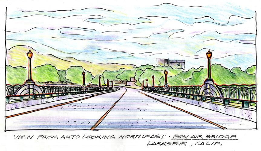
2 Bon Air Bridge

3 Why Replace the Bridge? The Bridge is structurally deficient Improve access and safety for pedestrians and bicyclists Multi-use paths, dedicated bike lanes Barrier separation
4 Bridge History 1958 Original Bridge was built and 1994 Major foundation repair & walkway widening/ seismic retrofit 2000 and 2003 deficiency reports 2005 Replacement bridge determined to be the most costeffective 2006 The City applied for and received funding through the Highway Bridge Replacement Program (federal grant) to replace the Bon Air Bridge Temporary supports were added to stabilize the structure.
5 Project History 2006 The City applied for and received funding through the Highway Bridge Replacement Grant to replace the Bon Air Bridge The final concept design for the bridge, a result of extensive public outreach is approved by the City Council Both California Environmental Quality Act CEQA and National Environmental Protection Act NEPA certifications were completed for the project, based on the 30% project development plans Permits obtained through RWQCB, US Fish & Wildlife, Army Corps of Engineers, California Fish and Wildlife and BCDC Design of Mitigation projects triggered by permitting Utility relocations initiated by Comcast, MMWD, PG&E, and AT&T Final design completed.


6 Mitigation Projects RWQCB BON AIR ROAD BRIDGE PROJECT CEQA/ NEPA PERMITS USFW ACoE CFW BCDC MITIGATION PROJECTS TIDAL MARSH PUBLIC DOCKS MAGNOLIA AVENUE


7 Environmental Mitigation APE = Area of Potential Effect


8 Mitigation Projects RWQCB USFW ACoE CFW BCDC MITIGATION PROJECTS TIDAL MARSH PUBLIC DOCKS MAGNOLIA AVENUE

9 Magnolia Water Quality Facilities Four methods of offsetting the water quality impacts of the bridge project: 1. Improving the existing drainage ditch 2. Removing paving to increase the landscaped median 3. Add grassy swales to the Hillview Greenway 4. Underground infiltration These projects all have benefits beyond meeting the permit requirements and are eligible for 89% federal funds

10 Conversion of Asphalt to Landscape Conversion of asphalt travel lanes to landscaped median: Partially satisfies 401 permit requirements Mitigates tree\ pavement issues Allows for replacement landscaping and irrigation
 Traffic memo maintains")
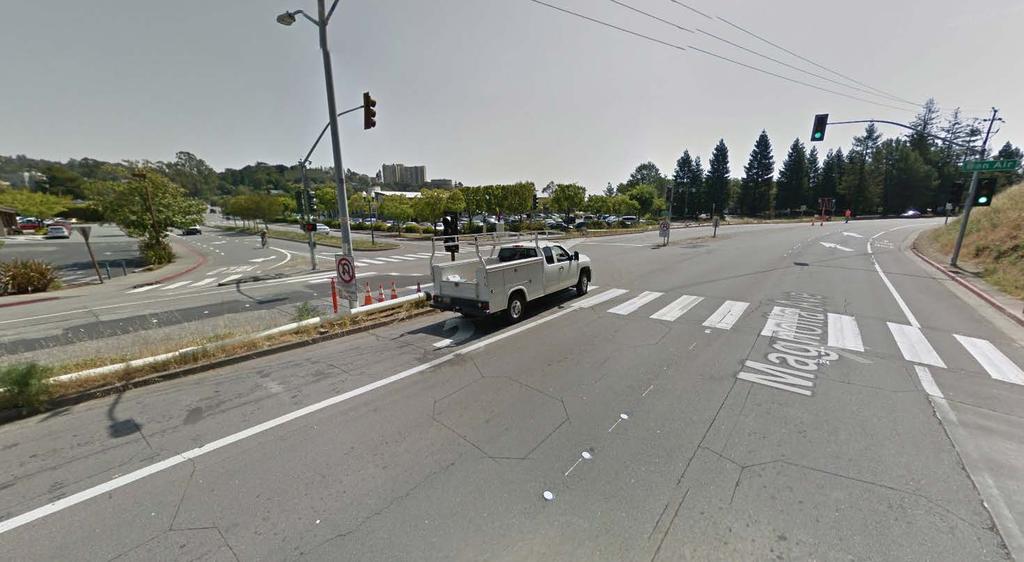
11 Impacts of lane reduction Viability of lane reduction: Consistent w/ segments south and north (already 2 lanes) and south segment carries more traffic Magnolia traffic flow controlled primarily by intersection operation, not the number of lanes Bon Air/ Magnolia would be similar to Doherty/ Magnolia (which has more traffic) Traffic memo maintains LOS

12 Proposed Improvements At Dartmouth / Skylark intersection The intersection remains unchanged. The corridor constricts south of the northbound approach lanes

13 Proposed Improvements At Bon Air Road intersection The NB and SB Magnolia approaches are reduced to one through lane. The Bon Air Road slip lanes are eliminated.

14 Proposed Improvements Schematic

15 Proposed Improvements Schematic
16 Proposed implementation Bridge Plans complete waiting for Caltrans process Mitigation Plans final design stage construction next year Magnolia Water Quality Facilities Project lane reduction partially implemented with 15/16 Pavement Project City proposes: 1. Finalizing pavement project using traffic paint (in lieu of permanent thermoplastic striping for northbound lane reduction) 2. Observing and monitoring the performance of the NB reduced lane configuration. 3. Documenting NB performance via follow-up traffic study during school year. 4. Public outreach including follow-up meeting in 4-6 months to share experiences and traffic data.
17 Bridge Schedule Update Start - spring 2017 close bike lane & upstream walkway Summer 2017 Fall 2018 Install temporary trestles, demolish upstream portion of existing bridge, abutment construction, utility & right-ofway work north and south of the bridge and construct upstream side of new bridge Fall 2018 through summer 2020 Move traffic to new upstream bridge, demolish remaining bridge, construct new downstream half Completion - fall 2020
18 Bridge Project Construction Impacts Approximately 3-4 years of construction from Fall 2015 to Fall 2019, 5-6 days per week Monday Friday 7:00AM to 6:00PM, Saturday 8:00AM to 5:00PM Periodic night work Periodic pedestrian and bike traffic control for safety and utility service requirements Periodic one-way traffic on bridge (10- to 15-minute delays) Periodic waterway traffic control Anticipated full closures: 2 weeks for delivery and installation of precast girders 1 week for closure pour between upstream and downstream halves of new bridge
19 Questions?
OPERATING BUDGET
 PUBLIC WORKS OPERATING BUDGET 2017-18 LARKSPUR CITY COUNCIL MEETING APRIL 19, 2017 UBLIC WORKS OPERATING BUDGET 2017-18 APRIL 19, 2017 PUBLIC WORKS ENGINEERING STREETS AND FACILITIES MAINTENANCE PARK MAINTENANCE
Bucks Bar Road Bridge Project Public Informational Meeting Wednesday, January 6, 2010
 PRESENTED BY: Bucks Bar Road Bridge Project Public Informational Meeting Wednesday, January 6, 2010 Matthew Smeltzer, P.E. Deputy Director of Engineering, DOT Supervisor Ray Nutting El Dorado County, District
I-66 EASTBOUND WIDENING INSIDE THE BELTWAY PARDON OUR DUST MEETING
 I-66 EASTBOUND WIDENING INSIDE THE BELTWAY From the Dulles Connector Road (Route 267) to Fairfax Drive (Route 237) PARDON OUR DUST MEETING Bill Cuttler, PE (VDOT District Construction Engineer, Northern
WELCOME! 8 8:30 6: TH STREET IMPROVEMENTS. Open House. Presentation & Q&A
 WELCOME! 168 TH STREET IMPROVEMENTS 6:30 Open House 7 8 Presentation & Q&A 8 8:30 Open House WELCOME Todd Pfitzer City of Omaha Engineer Bob Stubbe City of Omaha Public Works Director Jon Meyer Project
(BRIDGE NO. 36C-0223)
") City of Palo Alto Newell Road Bridge Replacement (BRIDGE NO. 36C-0223) TYPE SELECTION REPORT DRAFT November 2012 City of Palo Alto Newell Road Bridge Replacement (BRIDGE NO. 36C-0223) TYPE SELECTION REPORT
City of Palo Alto Newell Road Bridge Replacement (BRIDGE NO. 36C-0223) TYPE SELECTION REPORT DRAFT November 2012 City of Palo Alto Newell Road Bridge Replacement (BRIDGE NO. 36C-0223) TYPE SELECTION REPORT
INFRASTRUCTURE EXISTING INFRASTRUCTURE A. Circulation B. Signals C. Drainage D. Utilities
 7.01. EXISTING INFRASTRUCTURE A. Circulation B. Signals C. Drainage D. Utilities 7.02. PROPOSED INFRASTRUCTURE A. Overall Concept B. Circulation C. Signals D. Drainage 7.03. INFRASTRUCTURE MAP A. Key Infrastructure
North Carolina Department of Transportation Project Development and Environmental Analysis Branch
 North Carolina Department of Transportation Project Development and Environmental Analysis Branch Citizens Informational Workshop I-85, from I-485 to NC 73 Mecklenburg and Cabarrus Counties October 30,
Expo Line Transit Project. Project Status Update Meeting West End Corridor Segment C
 Exposition Light Rail Transit Project Project Status Update Meeting West End Corridor Segment C Culver City Senior Center November 18, 2010 Phase 1 Project Description Phase 1 from Downtown Los Angeles
Clay Street Bridge Replacement Project
 Clay Street Bridge Replacement Project Frequently Asked Questions (FAQs) No. 2 April 4, 2018 The project is located in downtown Placerville on Clay Street between US Highway 50 and Main Street and Cedar
SR-2 Freeway Terminus Improvement Project
 SR-2 Freeway Terminus Improvement Project Welcome! Public Hearing, Mayberry Elementary June 16, 2009, 6:30 p.m. 8:30 p.m. Agenda 6:30 PM 6:50 PM Registration and Open House 6:50 PM 7:00 PM Welcome and
Potential Green Infrastructure Strategies May 6, 2015 Workshop
 Potential Green Infrastructure Strategies May 6, 2015 Workshop Background The City of Cortland is developing the Tioughnioga Urban Headwaters Green Infrastructure Action Plan with funding from the National
MARINA BAY NEIGHBORHOOD PRESENTATION. City of Richmond Officer Bradley A. Moody Memorial Underpass. April 11, 2012
 MARINA BAY NEIGHBORHOOD PRESENTATION City of Richmond Officer Bradley A. Moody Memorial Underpass April 11, 2012 TEAM INTRODUCTIONS Project Oversight and Approval City of Richmond Formally Richmond Community
Fall 2017 Construction Update
 Fall 2017 Construction Update Ward 4 Southeast Engineering Department Riverwalk Red Multi-Use Trail Bridge Rehabilitation The Riverwalk Red Multi Use Trail Bridge was awarded to Cramer and Associates,
FANSHAWE PARK ROAD/RICHMOND STREET INTERSECTION IMPROVEMENTS. PUBLIC INFORMATION CENTRE 2 June 16, 2016
 FANSHAWE PARK ROAD/RICHMOND STREET INTERSECTION IMPROVEMENTS Municipal Class Environmental Assessment PUBLIC INFORMATION CENTRE 2 June 16, 2016 ACCESSIBILITY Under the Accessibility Standards 2015 for
PROPOSED IMPROVEMENTS
 IV. PROPOSED IMPROVEMENTS The proposed improvements for each alternative carried forward are discussed below. A. FUNCTIONAL CLASSIFICATION AND ROADWAY CROSS-SECTIONS The classifications of the roadways
Project Location. Jay and Patty Baker Park and Gordon River Greenway Connector Bridge. Naples Beach Golf Club. Gordon River. East. Naples.
 Gordon River Project Location Naples Beach Golf Club East Naples Naples Naples Bay Evergreen Golf and Country Club and Gordon River Greenway Connector Bridge Gordon River Greenway CONNECTOR BRIDGE AND
Fairfax County Parkway (Route 286) Widening Project
 Widening Project") Fairfax County Parkway (Route 286) Widening Project Route 29 (Lee Highway) to Route 123 (Ox Road) State Project No. 0286-029-259, P101; UPC 107937 Fairfax Station HOA Meeting January 30, 2018 7:00 to 9:00
Fairfax County Parkway (Route 286) Widening Project Route 29 (Lee Highway) to Route 123 (Ox Road) State Project No. 0286-029-259, P101; UPC 107937 Fairfax Station HOA Meeting January 30, 2018 7:00 to 9:00
Hunt Highway CELESTE PEMBERTON, CFM, CPM PINAL COUNTY CARLOS SANCHEZ SORIA, PE T.Y. LIN INTERNATIONAL
 Hunt Highway CELESTE PEMBERTON, CFM, CPM PINAL COUNTY CARLOS SANCHEZ SORIA, PE T.Y. LIN INTERNATIONAL Agenda Design Concept Report Phase 1 Phase 2 Phase 3 Phase 4 Phase 5 Questions Design Concept Report
2 ALTERNATIVES AND OPTIONS
 2 ALTERNATIVES AND OPTIONS This chapter documents the process used to develop improvement concepts for Oregon Avenue and describes the resulting project alternatives and options, which were developed in
Rt. 29 Solutions Project Delivery Advisory Panel. December 3, 2015
 Rt. 29 Solutions Project Delivery Advisory Panel December 3, 2015 Agenda item 1: Introductions Project Delivery Advisory Panel Technical Team 2 Agenda item 2: Interaction and Feedback Live Streaming Nov
Index to Projects by Project Name
 Index to Projects by Project Name 2062 1701 & 1711 Concord Avenue Purchase and Demolition of Structures 85 1279 1024 UF-802 UF-803 Affordable Housing 77 Annual CIP/TIP Management Program 105 Arnold Industrial
Cottage Grove Road Reconstruction. City of Madison Engineering
 Public Informational Meeting Cottage Grove Road Reconstruction October 8, 2015 Presentation Outline Introduction Project Purpose & Need Proposed Design Overview Environmental Concerns Pedestrian Needs
CONFORMED AGREEMENT INCORPORATED REVISIONS PER AMENDMENT DATED: APRIL 2, 2013 FOR REFERENCE
 CONFORMED AGREEMENT INCORPORATED REVISIONS PER AMENDMENT DATED: APRIL 2, 2013 FOR REFERENCE CITY STREETS AS PART OF STATE HIGHWAYS GUIDELINES REACHED BY THE WASHINGTON STATE DEPARTMENT OF TRANSPORTATION
TOWN OF PALM BEACH FOR IMMEDIATE RELEASE. Patricia Strayer, P.E., Town Engineer Phone: ,
 TOWN OF PALM BEACH DATE: October 18, 2018 FOR IMMEDIATE RELEASE MEDIA CONTACT: Patricia Strayer, P.E., Town Engineer Phone: 561-838-5440, Email: pstrayer@townofpalmbeach.com Construction and Traffic Highlights
Anderson Memorial Bridge Rehabilitation Project Boston/Cambridge
 Anderson Memorial Bridge Rehabilitation Project Boston/Cambridge MEPA Meeting, EEA#14702 Wednesday, March 2, 2011 6:30 PM Dr. Martin Luther King, Jr. School 100 Putnam Avenue, Cambridge, MA Rendering by:
Shell Beach Road Streetscape Frequently asked Questions
 Shell Beach Road Streetscape Frequently asked Questions General What is the Shell Beach Road Streetscape Improvements Project? The overall goal of the Shell Beach Road Streetscape Improvement project is
FREEWAY MAINLINE FAIR SHARE WEEKDAY PM PEAK HOUR
 APPENDIX C FREEWAY MAINLINE FAIR SHARE WEEKDAY PM PEAK HOUR Freeway Segment Direction From To Existing Cumulative No Project Cumulative Plus Project Fair Share % * North Street Riverside Avenue 1,986 3,260
Rt. 29 Solutions Project Delivery Advisory Panel. January 7, 2016
 Rt. 29 Solutions Project Delivery Advisory Panel January 7, 2016 Agenda item 1: Introductions Project Delivery Advisory Panel Technical Team 2 Agenda item 2: Interaction and Feedback Live Streaming Dec
NOTICE OF PREPARATION
 NOTICE OF PREPARATION To: All Interested Parties Subject: Notice of Preparation of an Environmental Impact Report From: City of Petaluma Address: 11 English Street, Petaluma, CA 94952-2610 Contact: Heather
Public Works Project Delivery Report
 Public Works Project Delivery Report May 2017 San Gabriel Public Works delivers reliable infrastructure & welcoming public spaces by designing, constructing, operating & maintaining the City s streets,
California Environmental Quality Act (CEQA) Environmental Review Process
 Environmental Review Process") California Environmental Quality Act (CEQA) Environmental Review Process Los Angeles Union Station Forecourt and Esplanade Improvements constitute a Project Los Angeles County Metropolitan Transportation
California Environmental Quality Act (CEQA) Environmental Review Process Los Angeles Union Station Forecourt and Esplanade Improvements constitute a Project Los Angeles County Metropolitan Transportation
West Dennis Center: Bass River to Old Main Street. West Dennis Business District: Old Main Street to Dennis Commons
 West Dennis Center: Bass River to Old Main Street West Dennis Business District: Old Main Street to Dennis Commons Dennisport Center: Dennis Commons to Division Street Main Street Project Goals Project
TOWN OF PALM BEACH FOR IMMEDIATE RELEASE. Patricia Strayer, P.E., Town Engineer Phone: ,
 TOWN OF PALM BEACH DATE: October 19, 2017 FOR IMMEDIATE RELEASE MEDIA CONTACT: Patricia Strayer, P.E., Town Engineer Phone: 561-838-5440, Email: pstrayer@townofpalmbeach.com Construction and Traffic Highlights
FY STATEWIDE TRANSPORTATION IMPROVEMENT PROGRAM New Jersey Department of Transportation Projects
 Garden State Parkway, Interchange 67, at Bay Avenue, CR 554 NS0210 NS0210 This project will provide new and modified movements to the Garden State Parkway, Interchange 67 at Bay Avenue (CR 554). Currently,
The Illinois Department of Transportation and Lake County Division of Transportation. Route 173, including the Millburn Bypass
 The Illinois Department of Transportation and Lake County Division of Transportation welcome you to this Public Hearing for U.S. Route 45 from Illinois Route 132 to Illinois Route 173, including the Millburn
Canal Road City Limits (East of Van Dyke Ave) to Saal Road
 to Saal Road") Canal Road City Limits (East of Van Dyke Ave) to Saal Road Construction Update 9/14/2018 The ashalt paving on the southside of Canal Road is expected to start Saturday, September 15 (weather permitting)
Canal Road City Limits (East of Van Dyke Ave) to Saal Road Construction Update 9/14/2018 The ashalt paving on the southside of Canal Road is expected to start Saturday, September 15 (weather permitting)
STATE OF TENNESSEE DEPARTMENT OF TRANSPORTATION ENVIRONMENTAL DIVISION
 STATE OF TENNESSEE DEPARTMENT OF TRANSPORTATION ENVIRONMENTAL DIVISION Suite 900 - James K. Polk Building 505 Deaderick Street Nashville, Tennessee 37243-0334 MEMORANDUM TO: FROM: Files Joe W. Matlock,
STATUS REPORT ENVIRONMENTAL REVIEW FOR IMPROVED ACCESS. at the NORTH WHITE PLAINS STATION
 STATUS REPORT ENVIRONMENTAL REVIEW FOR IMPROVED ACCESS at the NORTH WHITE PLAINS STATION May 2009 Status Report- Environmental Review for Improved Access at the North White Plains Station A. INTRODUCTION
7.5 Impacts on the Section 4(f) Properties
 Properties") constructive use, such as noise, air quality and visual impacts were also assessed. It was determined that this project would not introduce changes of an external nature that would affect the recreational
constructive use, such as noise, air quality and visual impacts were also assessed. It was determined that this project would not introduce changes of an external nature that would affect the recreational
Open House RIVER DES PERES GREENWAY: LANSDOWNE SHREWSBURY METROLINK TO FRANCIS R. SLAY PARK
 Open House 10.12.16 RIVER DES PERES GREENWAY: LANSDOWNE SHREWSBURY METROLINK TO FRANCIS R. SLAY PARK MEETING AGENDA Great Rivers Greenway and Project Partners River des Peres Greenway Overview Project
FY 2005 TRANSPORTATION CAPITAL PROGRAM
 Camden County Civic Center Access Study, Pennsauken 03340 This project will address operational and access improvements on Routes 30, 73 and 90 related to the Crossroads redevelopment project around the
Victoria Bridge Municipal Class EA Civic Works Committee
 Municipal Class EA John Pucchio, P. Eng., Project Manager June 19 2018 Introduction Existing Conditions Municipal Class EA Proposed Bridge Proposed Road Reconstruction Proposed Improvements Construction
Street Flooding Mitigation Plan KYOVA Interstate Planning Commission. Presented to AMPO National Conference October 18, 2017
 Street Flooding Mitigation Plan KYOVA Interstate Planning Commission Presented to AMPO National Conference October 18, 2017 Saleem Salameh, Ph.D., P.E., M.ASCE Chet Parsons, AICP CTP Agenda: Background
4.1 Build Alternative 1 Construction Phasing
 SECTION 4 Implementation Plan This section discusses potential segmentation of the build alternatives into multiple projects for implementation of improvements to the NSH from Rabbit Creek Road to 36th
Preliminary Regulatory and Engineering
 Preliminary Regulatory and Engineering Overview For the Isle of Palms, South Carolina Prepared by: Applied Technology & Management, Inc. 941 Houston Northcutt Boulevard, Suite 201 Mount Pleasant, South
Update on the Bayfront Canal Bypass Project. Recommendation This an informational item only. No City Council action is required at this time.
 AGENDA ITEM H-7 continued from 4/18 Public Works STAFF REPORT City Council Meeting Date: 4/18/2017 Staff Report Number: 17-081-CC Informational Item: Update on the Bayfront Canal Bypass Project Recommendation
I-494 Rehabilitation Project SP (I-394 to Fish Lake Interchange) June 2014 Section 4(f) De Minimis Determination
 June 2014 Section 4(f) De Minimis Determination") I-494 Rehabilitation Project SP 2785-330 (I-394 to Fish Lake Interchange) June 2014 Section 4(f) De Minimis Determination State Project Number 2785-330 Federal Project No. NHPP-I494 (002) Trunk Highway:
I-494 Rehabilitation Project SP 2785-330 (I-394 to Fish Lake Interchange) June 2014 Section 4(f) De Minimis Determination State Project Number 2785-330 Federal Project No. NHPP-I494 (002) Trunk Highway:
Environmental Critical Issues Report
 Environmental Critical Issues Report May 25, 2018 DRAFT Deliverable Task 9.1 Prepared for: Prepared by: Historical Research Associates, Inc. Blank Page Pacific Avenue SR 7 Corridor HCT Feasibility Study
FY STATEWIDE TRANSPORTATION IMPROVEMENT PROGRAM New Jersey Department of Transportation Projects
 ROUTE/ Project ID No. TIP No. Burlington County Computerized Signal Control, IV D9911 D9911 This ITS project will be a traffic responsive signal system, consisting of 24 intersections--9 on CR 607, 4 on
SECTION 4(f) DE MINIMIS DOCUMENTATION
 DE MINIMIS DOCUMENTATION") SECTION 4(f) DE MINIMIS DOCUMENTATION Illinois Route 60/83 IL 176 to the intersection of IL 60 (Townline Road) Lake County P-91-084-07 Mundelein Park and Recreation District Project Limit SECTION 4(f)
SECTION 4(f) DE MINIMIS DOCUMENTATION Illinois Route 60/83 IL 176 to the intersection of IL 60 (Townline Road) Lake County P-91-084-07 Mundelein Park and Recreation District Project Limit SECTION 4(f)
Project Study Report Equivalent The Old Road Widening SIX FLAGS MAGIC MOUNTAIN. On Street The Old Road Between Magic Mountain Pkwy And Turnberry Lane
 Project Study Report Equivalent The Old Road Widening SIX FLAGS MAGIC MOUNTAIN On Street The Old Road Between Magic Mountain Pkwy And Turnberry Lane On Street Henry Mayo Drive Between The Old Road And
LOUISIANA STATE UNIVERSITY COMPREHENSIVE & STRATEGIC CAMPUS MASTER PLAN. APPENDIX G - Stormwater Study Findings & Stormwater Solutions
 LOUISIANA STATE UNIVERSITY COMPREHENSIVE & STRATEGIC CAMPUS MASTER PLAN APPENDIX G - Stormwater Study Findings & Stormwater Solutions LSU: MP Narrative July 2017 3.5 Open Space Existing Conditions The
Project Status. Construction is underway for Phase 3. Overall Project Area and Schedule. Schedule of Current Construction Phases.
 I-95 Avenue Interchange Project Status Construction is underway for Phase 3. Overall Project Area and Schedule Phase 0: Completed 2010 Section GR0: Completed in Fallin 2010 Phase 2: Completed Section GR2:
Municipal Class EA Study Public Information Centre No. 1 December 13, :00 pm 7:00 pm. Please sign in so we can keep you updated on this study
 Reconstruction of Regional Road 45 (Creek Road) Between Regional Road 27 (River Road) and Regional Road 63 (Canborough Road) in the Township of Wainfleet Municipal Class EA Study Public Information Centre
I. DESCRIPTION OF PROPOSED ACTION... 1 A. General Description... 1 B. Historical Resume and Project Status... 2 C. Cost Estimates...
 PROJECT COMMITMENTS SUMMARY... S-1 1. Type of Action... S-1 2. Description of Action... S-1 3. Summary of Purpose and Need... S-1 4. Alternatives Considered... S-2 5. NCDOT Alternatives Carried Forward...
PUBLIC HEARING. Thursday, December 14, 2017 FDOT Urban Office 2198 Edison Avenue Jacksonville, FL 32204
 DISTRICT TWO PUBLIC HEARING I 10 (SR 8) from I 295 to I 95 Project Development & Environment Study Duval County, Florida Financial Project Number 213326 2 22 01 Efficient Transportation Decision Making
Lincoln 270. City of Lincoln. Stormwater Management Plan. April 2, 2013
 Lincoln 270 City of Lincoln Stormwater Management Plan April 2, 2013 # 2005.48 Prepared By: Civil Engineering Solutions, Inc. 590 E Street Lincoln, Ca 95648 (916) 645 5700 1.0 Background: The project site
Executive Summary. The goals of the Plan are to:
 Executive Summary The Wiscasset Bath Road Master Plan (Plan) seeks to maximize development opportunities along Bath Road through the strategic coordination of traffic infrastructure improvements, land
Downtown Redevelopment Project Update
 Downtown Redevelopment Project Update The redevelopment project will begin the week of September 4, 2017. It is anticipated that construction will be approximately 565 days, depending on weather. 7-6-18
Transportation Enhancements TE-2012-US Fish and Wildlife Service Quality of Life. Type of Improvement
 Transportation Enhancements 2012 Quality_of_Life Type of Improvement Infrastructure Bikeway Pedestrian Safety Quality of Life Purpose Primary project purpose is for constructing new bikeways (e.g. bike
Municipality of Anchorage. Community Council Survey Capital Projects Needs Ranking Survey (ALPHABETICAL) Airport Heights
 Airport Heights") ANCHORAGE PARKS & RECREATION Nichols Park Design and improve neighborhood park 2008 Challenge Grant applicant. 2008 $500K State Grant for Neighborhood Parks. Tikishla Park Lighting, paved parking, hockey
ANCHORAGE PARKS & RECREATION Nichols Park Design and improve neighborhood park 2008 Challenge Grant applicant. 2008 $500K State Grant for Neighborhood Parks. Tikishla Park Lighting, paved parking, hockey
GREEN SHEET ENVIRONMENTAL COMMITMENTS FOR THE IOWA HIGHWAY 100 EXTENSION
 County: Linn County, IA GREEN SHEET Location: IA 100, from its terminus at Edgewood Rd. to US 30 southwest of Cedar Rapids Route: IA 100 Extension Project No.: NHS-100-1(36) 19-57 OLE Project Managers:
Honorable Mayor and Members of the City Council. Submitted by: Eric Angstadt, Director, Planning and Development
 Office of the City Manager ACTION CALENDAR January 29, 2013 To: From: Honorable Mayor and Members of the City Council Christine Daniel, City Manager Submitted by: Eric Angstadt, Director, Planning and
Section 4(f) De Minimis Memorandum for the Hickman Road over Tuolumne River Bridge Replacement Project (Bridge No. 38C 0004)
 De Minimis Memorandum for the Hickman Road over Tuolumne River Bridge Replacement Project (Bridge No. 38C 0004)") 11060 White Rock Road, Suite 200 Rancho Cordova, CA 95670 Phone: (916) 363 4210 Fax: (916) 363 4230 M e m o r a n d u m To: Julie Myrah, Branch Chief Date: May 5, 2017 California Department of Transportation
11060 White Rock Road, Suite 200 Rancho Cordova, CA 95670 Phone: (916) 363 4210 Fax: (916) 363 4230 M e m o r a n d u m To: Julie Myrah, Branch Chief Date: May 5, 2017 California Department of Transportation
California State University, Monterey Bay Campus Parking Relocation Project Attachment to Notice of Exemption
 California State University, Monterey Bay Campus Parking Relocation Project Attachment to Notice of Exemption California State University, Monterey Bay (CSUMB) proposes to improve an existing oncampus
SAN FRANCISCO MUNICIPAL TRANSPORTATION AGENCY
 THIS PRINT COVERS CALENDAR ITEM NO. : 10.3 DIVISION: Sustainable Streets BRIEF DESCRIPTION: SAN FRANCISCO MUNICIPAL TRANSPORTATION AGENCY Approving the removal of Municipal Railway bus zones at various
FY STATEWIDE TRANSPORTATION IMPROVEMENT PROGRAM New Jersey Department of Transportation Projects
 69th Street Bridge 02311 02311 A grade separation at 69th Street would eliminate the current at-grade crossing which causes frequent automobile delays due to long freight trains moving through this area.
Start of works exhibition
 Start of works exhibition Find out about the work that Highways England are undertaking to create a new interchange junction 700 metres east of junction 10 over the M20, a dual carriageway link road to
Community Workshop. City of Richmond. January 25, 2011 SF Bay Trail Connection - Castro St to Richmond-San Rafael Bridge
 Community Workshop City of Richmond 1 City of Richmond Lead Agency BPAC Richmond Community ABAG Design and Process Funding Partner Caltrans Environmental; Process Review Design Process State and Federal
Olde Towne Vision Plan
 Olde Towne Vision Plan Introduction In 2016, the City of Bellevue will complete its move of City offices from Olde Towne Bellevue to its new municipal complex on Wall Street. The City intends to sell its
Index to Projects by Project Name
 Index to Projects by Project Name Project # PROJECT NAME PAGE 2134 2119 PR-1109 Clayton Road (Market Street to Oakland Avenue) Sidewalk Repair 911 System Replacement and Dispatch Room Remodel ADA Barrier
Rosecrans/Marquardt Grade Separation Project. Community Open House Meeting
 Rosecrans/Marquardt Grade Separation Project Community Open House Meeting October 17, 2017 Rosecrans/Marquardt Presentation Agenda 1. Welcome Remarks & Introductions 2. Community Outreach 3. Project Goals
CAMPUS PLANNING COMMITTEE STAFF REPORT SAMARITAN SPORTS MEDICINE INSTITUTE AT OSU 10/21/2013
 Office of Capital Planning and Development; 130 Oak Creek Building; Corvallis, Oregon 97331-2001 CPC STAFF REPORT: SAMARITAN SPORTS MEDICINE INSTITUTE AT OSU CAMPUS PLANNING COMMITTEE STAFF REPORT SAMARITAN
Downtown Denver Morrison. Located 30 minutes from downtown Denver behind the hogback
 Downtown Denver Morrison Located 30 minutes from downtown Denver behind the hogback Founded in 1874 as a passageway gold mines to the west. Morrison is the gateway to the Bear Creek Canyon. Surrounded
Capital Projects in and near Odenton Town Center
 Capital Projects in and near Odenton Town Center Map ID Anne Arundel County Department of Public Works This project provides for the design, right of way acquisition, and construction of approximately
CITY OF PORTSMOUTH PLANNING DEPARTMENT. MEMORANDUM To: From:
 CITY OF PORTSMOUTH PLANNING DEPARTMENT MEMORANDUM To: From: Subject: Date: Planning Board Juliet T.H. Walker, Planning Director Jillian Harris, Planner 1 Staff Recommendations for the August 23, 2018 Planning
FY STATEWIDE TRANSPORTATION IMPROVEMENT PROGRAM New Jersey Department of Transportation Project Descriptions ($ millions)
") ADA Central, Contract 1 DBNUM: 15417 / UPC: 154170 This contract will bring projects into compliance with current ADA design requirements that could not be completed within original design or construction
ADA Central, Contract 1 DBNUM: 15417 / UPC: 154170 This contract will bring projects into compliance with current ADA design requirements that could not be completed within original design or construction
I-90 Mississippi River Bridge & Interchange Project
 I-90 Mississippi River Bridge & Interchange Project Presentation Outline I. Background: Context & Need for Project II. Preferred Alternative Overview III. Project Development IV. Project Management Tools
Proposed FY 2004 TRANSPORTATION CAPITAL PROGRAM New Jersey Department of Transportation Projects
 30 130 Collingswood/Pennsauken ( B) 155C Vicinity of Cooper River Bridge at Park Drive to 200 feet north of PATCO Railroad Bridge This project may provide for the construction of a proposed new bridge
PROJECTS UNDER CONSTRUCTION
 Project Name Project Status Project Funding Project Manager PJ 2144 Clayton Rd-Treat Blvd Intersection Improvements Widen the Clayton Road/Treat Blvd intersection and upgrade the traffic signal. Construction
TRANSPORTATION COMMITTEE
 TRANSPORTATION COMMITTEE CITY OF OTTAWA Ministry of Transportation Detailed Design Assignment G.W.P.# 4058-01-00 Highway 417 (Ottawa Queensway) Widening & Rehabilitation from Maitland Avenue to Island
Welcome. Northern Segment of Hwy 100 I-90 to South of Madison Street Meeting Goals:
 Welcome Northern Segment of Hwy 100 I-90 to South of Madison Street Meeting Goals: - Review Environmental Assessment - Share Preferred Alternative -Receive Public Comments 2003 EA Preferred Alternative
COMPLETE GREEN STREET CHECKLIST
 COMPLETE GREEN STREET CHECKLIST This document was developed to dissect the structure of an urban street and explore opportunities to make our streets more complete while also integrating green street strategies.
Eastside Transit Corridor Phase 2 Technical Study Update Community Outreach Meeting February 2017
 Eastside Transit Corridor Phase 2 Technical Study Update Community Outreach Meeting February 2017 Purpose of Tonight s Meeting Recap of Board motion (2014) and technical study process Provide update on
CITY OF SIMI VALLEY MEMORANDUM
 CITY OF SIMI VALLEY MEMORANDUM AGENDA ITEM NO. Consent (3) August 15, 2016 TO: FROM: City Council Department of Public Works SUBJECT: ADOPTION OF PLANS AND SPECIFICATIONS AND AUTHORIZATION TO SOLICIT CONSTRUCTION
PROJECT BACKGROUND. Preliminary Design Scope and Tasks
 PROJECT BACKGROUND Preliminary Design Scope and Tasks The purpose of this Study is the development of preliminary designs for intersection improvements for Trunk Highway (TH) 36 at the intersections of
Biology and Wildlife. Erosion, Drainage, and Storm water. Chavez Ranch Road Project Comment Response Table - Page 1 January 2017
 Air Quality Commenters are concerned that there would be increased particulate matter and introduction of chemical pollutants during the construction of the project that could affect the air quality and
Design Services for Wiles Road Broward County Project #104026
 Design Services for Wiles Road Broward County Project #104026 ORGANIZATIONAL CHART THE CGA TEAM Firm Services Key Staff CBE Calvin, Giordano & Associates, Inc. HBC Engineering Company Florida Engineering
LOS ANGELES COUNTY METROPOLITAN TRANSPORTATION AUTHORITY (LACMTA)
") CE OF PREPARAT LOS ANGELES COUNTY METROPOLITAN TRANSPORTATION AUTHORITY (LACMTA) NOTICE OF PREPARATION OF AN ENVIRONMENTAL IMPACT STATEMENT (E1S)lENVIRONMENTAL IMPACT REPORT (EIR) TO: AGENCIES, ORGANIZATIONS
CE OF PREPARAT LOS ANGELES COUNTY METROPOLITAN TRANSPORTATION AUTHORITY (LACMTA) NOTICE OF PREPARATION OF AN ENVIRONMENTAL IMPACT STATEMENT (E1S)lENVIRONMENTAL IMPACT REPORT (EIR) TO: AGENCIES, ORGANIZATIONS
AWR Engineering, LLC
 AWR Engineering, LLC Alaska Water Resources Memorandum To: Kirsti Bischofberger, Watershed Manager, Municipality of Anchorage From: Janie Dusel, PE Date: February 3, 2017 Re: 2016 Low Impact Development/Green
Prince William Street Project (Grant Avenue to Wellington Road)
") Prince William Street Project (Grant Avenue to Wellington Road) 1 Goals Improve pedestrian and bike traffic safety Improve street drainage with curb & gutter Upsize water mains Enhance overall street appearance
Prince William Street Project (Grant Avenue to Wellington Road) 1 Goals Improve pedestrian and bike traffic safety Improve street drainage with curb & gutter Upsize water mains Enhance overall street appearance
CHAIR AND MEMBERS PLANNING & ENVIRONMENT COMMITTEE GEORGE KOTSIFAS MANAGING DIRECTOR, DEVELOPMENT & COMPLIANCE SERVICES & CHIEF BUILDING OFFICIAL
 TO: CHAIR AND MEMBERS PLANNING & ENVIRONMENT COMMITTEE FROM: SUBJECT: GEORGE KOTSIFAS MANAGING DIRECTOR, DEVELOPMENT & COMPLIANCE SERVICES & CHIEF BUILDING OFFICIAL APPLICATION BY: 2261531 ONTARIO LIMITED
3.0 Existing Corridor Infrastructure
 3.0 Existing Corridor Infrastructure An analysis was conducted of the existing I-526 highway facility infrastructure to serve as a baseline for consideration of future improvements. The detailed analysis
Town of Yucca Valley Capital Improvement Projects Report July 24, 2014
 Town of Yucca Valley Capital Improvement Projects Report July 24, 2014 SR 62 Traffic and Pedestrian Improvements from Apache Trail to Palm Avenue (PLHD) The project includes construction of curbs, gutters,
CITY OF SIMI VALLEY MEMORANDUM
 CITY OF SIMI VALLEY MEMORANDUM AGENDA ITEM NO. 9.1 May 18, 2016 TO: FROM: Planning Commission Department of Environmental Services SUBJECT: REVIEW OF POTENTIAL FISCAL YEAR (FY) 2016-17 CAPITAL IMPROVEMENT
RFP DRAINAGE OUTFALL DESIGN AND PERMITTING. Mandatory Meeting for Proposers August 15, 2015
 RFP 2018-02 DRAINAGE OUTFALL DESIGN AND PERMITTING Mandatory Meeting for Proposers August 15, 2015 IMPORTANT DATES August 15 th, 2:00pm August 17 th, 5:00pm August 22 nd, 5:00pm September 5 th, 2:00pm
Floodplain Discipline Report
 Floodplain Discipline Report Duportail Street Bridge Project Benton County, Washington Prepared for: Federal Highway Administration 711 South Capitol Way, Suite 501 Olympia, WA 98501 Washington State Department
Open House Public Involvement Meeting Howland High School Cafeteria, 200 Shaffer Drive NE, Warren, Ohio. Informational Handout
 Open House Public Involvement Meeting Howland High School Cafeteria, 200 Shaffer Drive NE, Warren, Ohio SR 46 (Niles Cortland Road) and SR 82 Proposed Improvements Howland Township, Trumbull County, Ohio
I-25 / Rio Bravo Interchange. I-25 / Rio Bravo Interchange. Presenters 11/30/2016 THIRD PUBLIC MEETING DECEMBER 1, 2016 NMDOT CN A300280
 I-25 / Rio Bravo Interchange TONIGHT S MEETING SCHEDULE OPEN HOUSE 6:00 PM TO 6:30 PM PRESENTATION BEGINS AT 6:30 PM Q & A FOLLOWING PRESENTATION CN A300280 / PNA300280 I-25 / Rio Bravo Interchange THIRD
St. Clair Avenue West Area Transportation Master Plan
 1 (Between Keele Street and Old Weston Road) Public Information Centre 1 December 2, 2015 2 Welcome Welcome to the first Public Information Centre for the St. Clair Avenue West Area. The panels will present