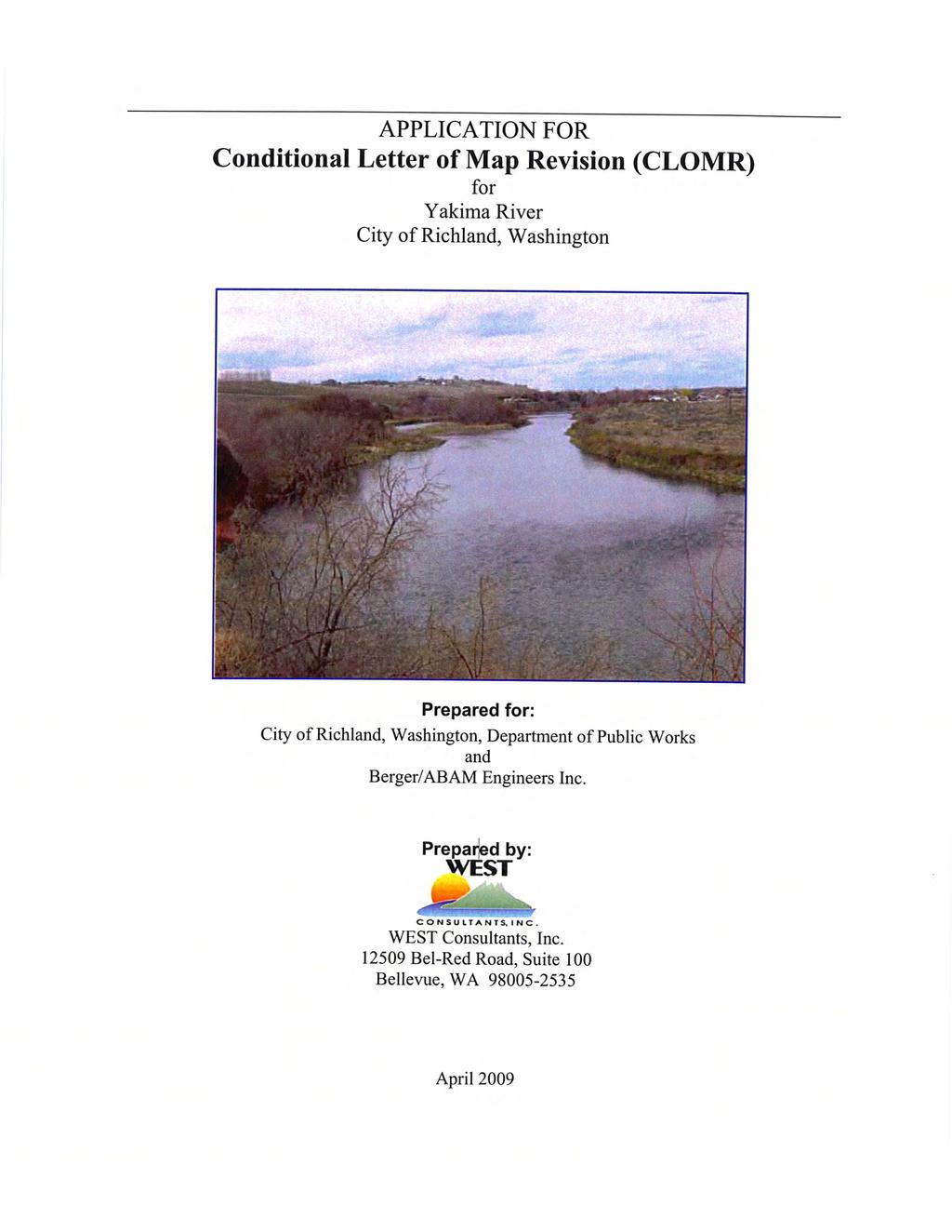
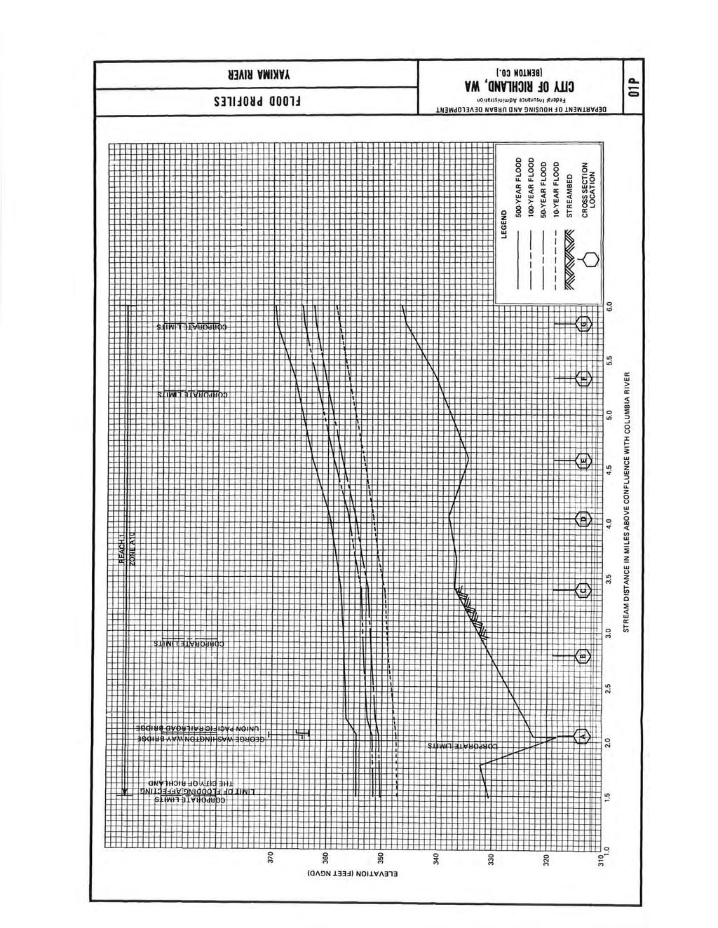
Floodplain Discipline Report
|
|
|
- Shauna Murphy
- 5 years ago
- Views:
Transcription
1 Floodplain Discipline Report Duportail Street Bridge Project Benton County, Washington Prepared for: Federal Highway Administration 711 South Capitol Way, Suite 501 Olympia, WA Washington State Department of Transportation P.O. Box Yakima, WA October July 15, 2011
2 This page left blank intentionally for printing purposes.
3 Acronyms BFE BMPs CID CLOMR EA FEMA FHWA FIRMs LOMR NEPA ROW SEPA SR WAC WSDOT USACE Base Flood Elevation Best Management Practices Columbia Irrigation District Conditional Letter of Map Revision Environmental Assessment Federal Emergency Management Agency Federal Highway Administration Flood Insurance Rate Maps Letter of Map Revision National Environmental Policy Act Right of Way State Environmental Policy Act State Route Washington Administrative Code Washington State Department of Transportation United States Army Corps of Engineers i
4 This page left blank intentionally for printing purposes. ii
5 Executive Summary This study analyzes whether there are any substantial effects to the floodplain in the vicinity of the proposed Duportail Street Bridge Project, located in the City of Richland. The project involves the construction of a four-lane bridge between the existing Duportail Street on the south-west side of the Yakima River, to Duportail Street on the north-east side of the river. In addition, intersection improvements at State Route (SR) 240 and Duportail Street will be included, as well as a new roadway (Tanglewood Drive) on the north side of the proposed bridge will be constructed to connect the existing land uses to Duportail Street. Infiltrations trenches and a new waterline, will be constructed. The current Columbia Irrigation Canal drainage will be enclosed under the proposed bridge. The proposed project is located within the legal geographic area of: Township 09 North, Range 28 East, Sections 15 and 16, Benton County, Washington. Existing land use along the project corridor consists of primarily natural open space, multi-family residential, and a few businesses. Refer to the Vicinity Map; Figure 1. A Bridge Hydraulics and Scour Assessment (WEST Consultants, Inc., 2009) written for the project was used as well as regulations, and maps from the City of Richland to identify the existing and potential future floodplain effects within the study area. Two alternatives were analyzed, the No Build and the Preferred Alternative. The No Build was essentially used as a baseline to compare the project effects to, as under the No Build no activities would be taking place, and the status quo is assumed to be maintained. This study shows that proposed bridge will cause a backwater rise of 0.08 feet. The hydraulic and scour assessment (WEST Consultants, Inc., 2009) recommends an estimated median riprap size of 2 feet to protect the right bank. Bank protection alternatives might be riprap, woody debris and vegetation, geo-textiles, and plantings. However, finding measures to protect the entire length of the right bank (as viewed downstream) through the bridge reach against bank erosion and lateral migration would be difficult. Further recommendations in the hydraulic and scour assessment states that the bridge foundation should be designed against significant scour and migration towards the right bank, and that the right bank be monitored after major floods, and if riprap protection were to be included in the design, the hydraulic and scour report recommends heavy-loose rock with a median size exceeding 2-ft to provide a factor of safety for the steep right bank. The proposed new bridge would place piers in the FEMA effective floodway of the Yakima River, and a backwater rise is anticipated, therefore mitigation must be considered. Two possible mitigation measures were analyzed. Based on the assessment, it is recommended that the City submit a Conditional Letter of Map Revision request to the Federal Emergency Management Agency to revise the mapping of the floodplain and floodway of the Yakima River in the bridge reach. Following approval from the Federal Emergency Management Agency, and following bridge construction, the City would then have to submit a Letter of Map Revision to the Federal Emergency Management Agency based on as built bridge drawings. Once the Federal Emergency Management Agency approves the Letter of Map Revision, and City ordinances are changed to reference the revised Flood Insurance Rate Maps, the Federal Emergency Management Agency will make the revised maps effective. iii
6 This page left blank intentionally for printing purposes. iv
7 Table of Contents Acronyms... i Executive Summary... iii 1.0 Introduction Purpose of Report Preferred Alternative No Build Purpose and Need Investigation of Potential Problems Affected Environment Limits of 100 year floodplain Proposed Project Drawings Studies and Coordination Project s Consistency with Existing Watershed and Floodplain Permits Required Current/proposed water resource projects Flood History Existing Structures Foundation Type Scour History Drainage area above encroachment Summary Objectives of the Project Current floodplain use Impacts of all alternatives including the no-build alternative Recommended mitigation References Appendix A: CLOMR Application Appendix B: Permits Required List of Figures Figure 1: Vicinity Map... 3 Figure 2: Limits of the FEMA-Effective and Existing 100-Year Floodplains... 9 Figure 3: Plan View of the Proposed Bridge Figure 4: Cross section of the Proposed Bridge v
8 This page intentionally left blank for printing purposes. vi
9 1.0 Introduction Floodplains are areas prone to periodic inundation and are generally associated with streams, rivers, or lakes. The Federal Emergency Management Agency (FEMA) maps floodplains that have at least a 1 percent probability of flooding in a given year. These floodplains are defined as 100-year floodplains because these areas flood on average once every 100 years. Flood Insurance Rate Maps (FIRMs) indicate FEMA-delineated floodplains. Unless a special critical area study has revised the FEMA floodplain, the zero-rise floodway is the FEMA 100-year floodplain area defined by the Base Flood Elevation (BFE). The Washington Administrative Code (WAC), specifically WAC (1)(h) indicates that abutments, piers, piling, sills, approach fills, etc. associated with new structures should not cause a backwater rise exceeding 0.2 feet in the floodplain. FEMA regulations require that the bridge should cause no rise within the regulatory floodway. The City of Richland does not have a more stringent regulation; therefore it is assumed that new development does not cause a measurable rise (0.1 foot or more) in BFE. 1.1 Purpose of Report The purpose of this Floodplain Discipline Report is to evaluate the Duportail Street Bridge Project for potential effects and benefits the project would have on floodplain resources and identify mitigation measures to address adverse effects as needed. The analysis includes a comparison of how the Preferred Alternative and No Build Alternative would affect the Yakima River floodplain, and an evaluation of consistency with existing city and regional land use plans and development regulations. The report also suggests mitigation measures to relieve negative effects during project construction. The information contained in this discipline report will be used to support the project s Environmental Assessment (EA). Analysis of floodplain effects is required under the National Environmental Policy Act (NEPA) for actions sponsored, funded, permitted, or approved by federal agencies. The State Environmental Policy Act (SEPA) requires analysis of a project s impact on the natural and built environment. 1.2 Preferred Alternative Within the proposed project area the FEMA effective floodplain and floodway are not consistent with the current position of the Yakima River. JUB, Inc.; therefore, conducted a detailed channel and overbank survey of the bridge reach from approximately 500 feet upstream of the proposed bridge crossing to about 1,000 feet downstream. The City of Richland provided some additional overbank survey from approximately 4,000 feet upstream of the proposed bridge to about 4, 000 feet downstream. This data was entered into HEC-RAS hydraulic model in order to calculate the existing 100-year floodplain and floodway of the Yakima River, between the areas 4,000 feet upstream and 3,300 feet downstream. The Bridge Hydraulics and Scour Assessment Detail Report (WEST Consultants, Inc., 2009) analyzed two bridge alternatives. Alternative 1 (4-span bridge 1 ) and Alternative 2 (5-span bridge) were compared against the existing conditions model for the base (100-year) flood. The two bridge alternatives were shown to cause a backwater rise upstream of 0.08 feet for the 4-1 Alternative 1 (4-span bridge) was modified to include an additional span for habitat mitigation after consulting with the US Army Corps of Engineers; however, the requested fifth span is outside both the floodway and the 100- year floodplain so backwater rise was not affected. 1
10 span bridge and 0.09 feet for the 5-span bridge. From this analysis, and considering site and design conditions, Alternative 1 was identified by the design team and City as the Preferred Alternative and will be referred to as the proposed project from now on in this floodplain discipline report. The City of Richland proposes to construct a four-lane bridge over the Yakima River, connecting the existing Duportail Street from its intersection with Queensgate Drive on the south-west side of the river to Duportail Street on the north-east side of the river to its intersection with SR 240. Refer to Figure 1: Vicinity Map. Project activities will include the following: Construction of a four lane bridge; with two 11-foot travel lanes and a 12-foot pedestrian/bicycle path on the upriver side of the bridge. Sidewalks will be installed from Queensgate Drive (southwest of Yakima River) to City View Drive. The northeast segment of Duportail Street will be extended south to connect with the proposed bridge, and will be widened north, to the intersection with Cottonwood Drive; sidewalks will be added where needed to connect with the existing network. Tanglewood Drive will be extended eastward to intersect with Duportail Street north of the proposed bridge and will terminate with a cul-de-sac approximately 700 feet east of the proposed intersection. The intersection of Duportail Street and SR 240 will be upgraded to handle higher traffic volumes. The BNSF railroad tracks running parallel to SR 240 will be raised to the same grade as the intersection of SR 240 and Duportail Street. SR 240 will be widened on both sides of intersection with Duportail Street due to the addition of right turn exit lanes from SR 240 onto Duportail Street. Existing boat launch parking will be relocated and an access road will be constructed to provide access to the proposed boat launch parking area from Tanglewood Drive. An additional access road will be constructed to provide access to the Desert Streams Bible Church from the Tanglewood Drive cul-de-sac; east of Duportail Street. One nature trail will be designated and all remaining disturbed areas, between the left bank of the Yakima River and Tanglewood Drive will be restored. The existing water main crossing within the Yakima River will be replaced. A new water main will be placed along the bridge and the current main will be abandoned in place. The existing Columbia Irrigation District (CID) canal south of the proposed bridge will be enclosed under the proposed bridge. Infiltration trenches will be installed along Tanglewood Drive, Duportail Street, and Riverstone Drive. 2

11 Columbia River Miles 1 in = 0.5 miles Duportail Street Bridge Figure 1: Vicinity Map Duportail Street Bridge Project City of Richland City of Richland June 8, 2011
12 This page left blank intentionally for printing purposes. 4
13 1.3 No Build NEPA requires that the No Build alternative be included and evaluated in this discipline report. This approach is used to establish an existing and future baseline for comparing the effects associated with the proposed project. The No Build Alternative is assumed to maintain the status quo: only routine activities such as road maintenance, repair, and safety improvements would occur within the corridor between now and The No Build Alternative does not include improvements that would increase roadway capacity or reduce congestion on feeder streets to I- 182 or other surface streets in the City of Richland. 1.4 Purpose and Need Purpose The purpose of this project is to alleviate congestion on the I-182 and SR 240 corridors in the city of Richland, to improve emergency vehicle response times to currently underserved areas of town, and improve mobility for bicycle and pedestrian users from the south side of the Yakima River to the north. A new fire station is planned at the approximate location of the intersection of Duportail Street and City View Drive. The proposed new connection over the Yakima River for emergency vehicles using Duportail Street would be a faster, more direct route in some cases. The proposed bridge will contain sidewalks and a bike lane, creating a safe crossing for nonmotorized traffic, as the design speed for the proposed bridge is 35 mph. The proposed new connection over the Yakima River can be used for a more direct route to shopping, employment, or other purposes. An additional north-south crossing in the city of Richland aims to improve mobility, and will substantially reduce the amount of local trips within the SR 240 and I-182 corridor areas. A new waterline will be constructed on the proposed bridge, and the current deteriorating, 36 waterline will be valved out of service and abandoned in place. A previous commitment has been made by the City to replace the waterline and the city has received a grant from the Federal Emergency Management Agency (FEMA) to reduce vulnerabilities to the waterline. Need The City of Richland is planning to serve the growing infrastructure needs of the city particularly emergency vehicle response times and non-motorized transportation by constructing an additional bridge over the Yakima River, connecting Duportail Street south of the Yakima River to Duportail Street north of the Yakima River. In addition, improvements are needed for the city s water pipeline in this area, which is now exposed in places and susceptible to damage or vandalism. There are four existing conditions associated with the roadway that require action to address the above needs: Reduce Emergency Response times on the South Side of the river Improve non-motorized access Improve the city s arterial street network connectivity to reduce the amount of local trips on SR 240 and I-182 Replace Exposed 36-inch waterline 5
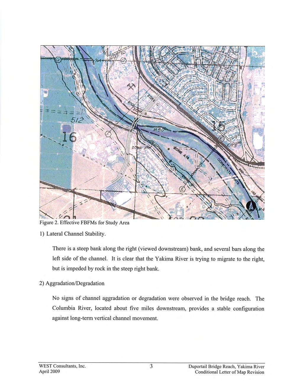
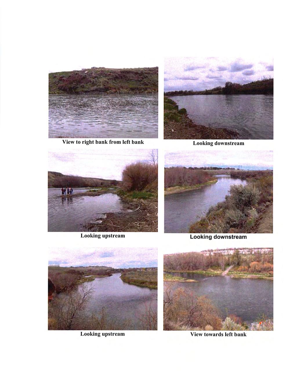
14 Reduce Emergency Response times on the South Side of the river Currently, there is only one crossing over the Yakima River in the city of Richland that services the new developments on the south side of the river. There are two other crossings, SR 224 in the north part of Richland, and SR 240 to the south of the city, however to take one of these routes would be lengthy and time consuming. The SR 224 crossing and the I-182 crossing are roughly 3 miles apart, SR 240 crosses just south of I-182. Emergency vehicles needing to get to the other side of the river must choose between crossing to the north, or crossing to the south, which may extend response times to locations located between the existing crossings. Improve non-motorized access The three existing crossings over the Yakima River in the city of Richland do not have designated bicycle or pedestrian access. This restricts non-motorized transportation to remaining on one side of town or the other. Improve the city s arterial street network connectivity to reduce the amount of local trips on SR 240 and I-182 I-182 is currently the only one of three crossings over the Yakima River that services the new developments on the south side of the river. Residential and retail developments southwest of the city center have created a need for more cars to travel over the I-182 Bridge. The I-182 Bridge is increasingly being used as a route for local trips from the city center to the newer developments. The need for local trips to use I-182 is anticipated only to increase as development and population rise. Increasing capacity on the existing crossings of the Yakima River will not solve the problem seen at the choke points in the city of Richland, as the choke points occur on local feeder streets to the main crossing (I-182). The Aaron Drive choke point can be alleviated by approximately 8,500 cars in the year 2012 and by approximately 12,000 cars in 2032 with the proposed bridge, as the current queued cars waiting to get on I-182 take an alternate, more distant crossing in order to continue their local travel. Exposed 36-inch waterline The existing 36-inch waterline that is the sole source of domestic water to all of the residents and businesses in southern Richland crosses the Yakima River near Duportail Street. The waterline is exposed in places as it crosses the river, leaving the waterline susceptible to potential further damage and vandalism. 1.5 Investigation of Potential Problems Flood Hazard The Duportail Road Bridge is within a regulatory (FEMA) floodplain as well as the existing floodplain; calculated using the HEC-RAS hydraulic model. WAC (1)(h) indicates that the bridge should not cause a backwater rise exceeding 0.2 feet in the floodplain. FEMA regulations require that the bridge should cause no rise within the regulatory floodway. The City of Richland does not have a more stringent regulation. Navigational clearance may be an issue at the bridge site, especially at the left (viewed downstream) bank. 6
15 The Yakima River limits access to and from the city center to 3 crossings routes - SR 224 to the north of the project, and I-182 and SR 240 to the south of the project. SR 224 has experienced closures due to flooding. Flood waters in January 2009 inundated one eastbound lane of SR 224 closing it for several days and during the 1996 flood the road was impacted by the flood for a total of 20 days, ten of which days the road was inundated and closed entirely. The elevation of the 1996 flood in the project area was feet. Over six additional floods since the 1970s have also caused transportation issues like the ones described above. The construction of the proposed Duportail Bridge would provide an additional transportation route in the event of SR 224 closure due to floodwaters. Channel Stability There is a steep bank along the right (viewed downstream) bank, and several bars along the left side of the channel. It is clear that the Yakima River is trying to migrate to the right, but is impeded by rock in the steep right bank. Effects on the environment- fish and wildlife, domestic water supplies, recreation Fish passage should not be adversely hydraulically impacted by the replacement of the bridge. Temporary effects to fish and wildlife are likely to occur during construction. A Biological Assessment and Wildlife Discipline report are being prepared to address effects to species in the project area. The existing 36 water transmission line crossing the Yakima River in the project area currently provides 100% of the primary potable water supply for the south Richland community, comprising a population of approximately 16,689 people. The existing waterline, constructed in 1953, was buried below the channel bottom of the Yakima River. However, 50+ years of erosion and scour have now partially exposed the pipe, rendering the pipe highly vulnerable to hydraulic forces, scour and ice flows. The hydraulic analysis and scour report recommended that if the proposed project were replacing the existing buried water main with a new buried pipe, the recommended burial depth should be approximately feet to protect the pipeline from streambed erosion. However, the proposed project includes construction of the water main on the proposed bridge. On the north side of the proposed bridge, there is currently access to several trails, likely used for hiking, bird watching, and access to the river for fishing. As mitigation for this project one trail will be designated through this area and all remaining disturbed areas will be revegetated with native vegetation. Pedestrian access to the riverfront will remain available through the boat ramp. Debris The minimum desired clearance from the low chord of the new bridge to the 100-year design flow water surface elevation, in locations along the bridge where debris is likely to be carried by the river, is 3 feet. Little debris potential exists. The banks are lined with shrubs and small diameter trees. 7
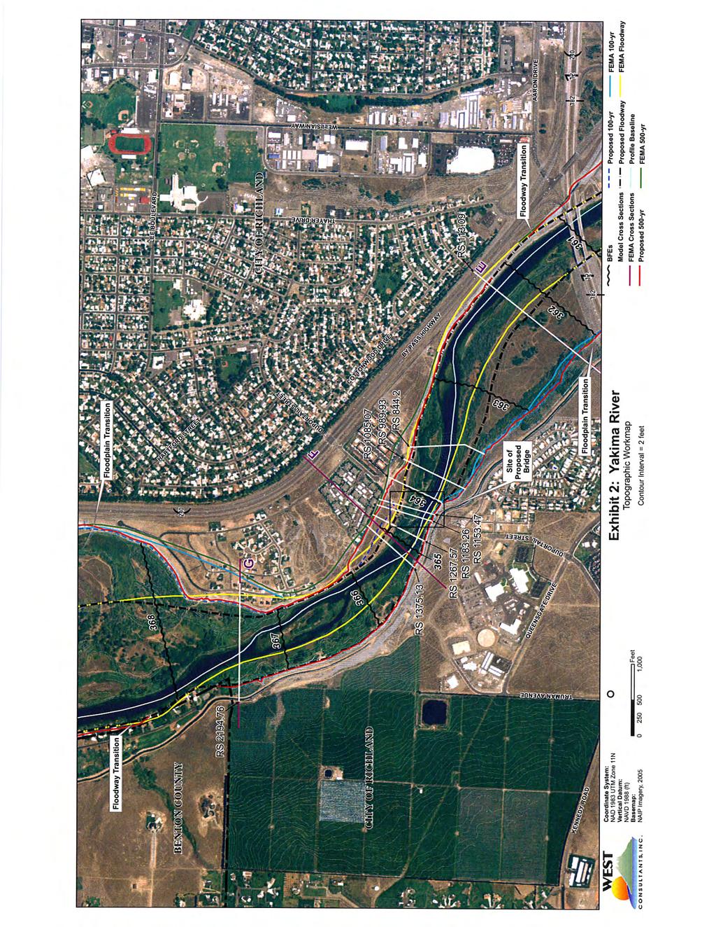
16 2.0 Affected Environment 2.1 Limits of 100 year floodplain Refer to Figure 2 for a map showing the proposed bridge, the limits of the FEMA Effective 100- year floodplain and floodway and the limits of the existing 100-year floodplain and floodway calculated using the HEC-RAS hydraulic model. 2.2 Proposed Project Drawings Refer to Figures 3 and 4 for construction drawings of the proposed bridge including proposed encroachment/structures, a cross-section of the stream, alignment of piers, and skew of crossing. 8
17 Feet 1 inch = 300 feet Legend Proposed Alignment Potential Laydown/Restoration Area - Zero Net Rise Proposed Designated Trail - Zero Net Rise Yakima River FEMA Effective 100-year Floodplain (modeled per FIS 1979) FEMA Effective Floodway (modeled per FIS 1979) "Existing" 100-year Floodplain (modeled per HEC-RAS 2009) "Existing" 100-year Floodway (modeled per HEC-RAS 2009) Figure 2: Limits of the FEMA Effective and "Existing" Floodplains Duportail Street Bridge Project City of Richland July 13, 2011
18 This page left blank intentionally for printing purposes. 10
19
20 This page left blank intentionally for printing purposes. 12
21
22 This page left blank intentionally for printing purposes. 14
23 3.0 Studies and Coordination 3.1 Project s Consistency with Existing Watershed and Floodplain The proposed project is consistent with the existing watershed as it will not change any characteristics of the watershed. As previously mentioned within the proposed project area the FEMA effective floodplain and floodway are not consistent with the current position of the Yakima River. Since these were mapped in 1979 the river has migrated to the south, and in places now lies beyond the floodway limits. The proposed project will result in a 0.08 foot backwater rise, and coordination between the City of Richland and FEMA is recommended to revise the current FEMA mapped floodplain and floodway. A Conditional Letter of Map Revision (CLOMR) has been submitted to the Federal Emergency Management Agency requesting they revise the FEMA designated floodplain and floodway of the Yakima River in the bridge reach to the existing floodplain and floodway calculated using the HEC-RAS hydraulic model in See Appendix A. 3.2 Permits Required A complete list of permits required for the Duportail Street Bridge project can be found in Appendix B. The Duportail Road Bridge is within a regulatory (FEMA) floodplain. State guidelines per the Washington Administrative Code (WAC) WAC (1)(h) indicates that the bridge should not cause a backwater rise exceeding 0.2 feet in the floodplain. FEMA regulations require that the bridge should cause no rise within the regulatory floodway. The City of Richland does not have a more stringent regulation than the FEMA regulations. 3.3 Current/proposed water resource projects A previous commitment has been made by the City to replace a waterline supplying domestic water to residences and businesses in southern Richland. The city has received a grant from FEMA to reduce vulnerabilities to the waterline. The existing 36-inch waterline crosses the Yakima River near Duportail Street. The waterline is exposed in places as it crosses the river, leaving the waterline susceptible to potential further damage and vandalism. The new waterline will be constructed with or without the proposed project, however, with the proposed project; the new waterline will be constructed on the proposed bridge. The current deteriorating, 36 waterline will be valved out of service and abandoned in place. 3.4 Flood History The Yakima River and its tributaries have been heavily altered for the purpose of irrigated agriculture. There are numerous dams and irrigation canals. Irrigation runoff is, in places, returned to the river through canal drains. The irrigation system in the Yakima's watershed causes periods of both severe river dewatering and elevated flows, relative to the historic stream flow regime. An irrigation ditch (CID canal) flows through the project area along the right bank (southwest side) of the Yakima River. This ditch is fed by the Yakima River; a pump station is located approximately 13 miles upstream from the project site. The project proposes to pipe a portion of the CID Canal under the proposed bridge. The canal will be excavated to lay the 15
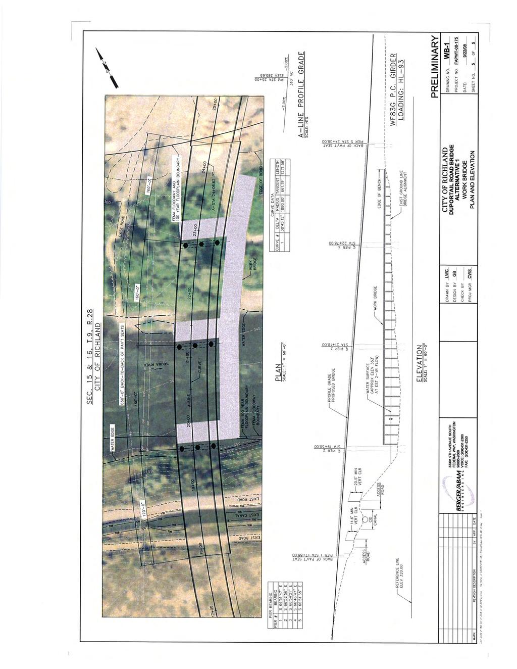
24 underground pipe. The pipe will be positioned to ensure proper flow of the canal. Since the 1970 s over six flood incidents have caused transportation issues. There are currently only three crossings of the Yakima River, and one of the crossings (SR 224) has been closed several times, (one time lasting 20 days) due to floods. 3.5 Existing Structures There are no existing structures in the project area. 3.6 Foundation Type Construction of the new bridge will be conducted from the temporary work bridge and from both riverbanks. The Duportail Bridge will be 775 feet in length with a minimum foot vertical clearance and a maximum foot clearance over the OHWM of the Yakima River. Construction will occur in three main sequences: 1) drilled shaft, column, cap beams and abutment installation, 2) concrete girder placement and 3) concrete deck construction. Piers 2 & 3 will be waterward of the OHWM, Pier 4 will be approximately 30 feet landward of the OHWM but within the limits of the 100-year floodplain, and Pier 5 will be waterward of the OHWM though it will abut the 100-year floodplain. All four of these piers will be supported by three 8-foot diameter concrete drilled shafts. See Figures 3 and 4 for the plan, elevation and typical cross section of the Duportail Bridge. The southern abutment (Pier 1) will be located on the right bank above the CID canal and the northeast abutment (Pier 6) will be located near the top of the slope of the riverbank. Both the southern abutment and northern abutments are well outside the 100-year floodplain. The Pier 1 abutment will be supported by a spread footing and the Pier 6 abutment will be supported by four 4-foot diameter concrete drilled shafts. 3.7 Scour History The total scour at the bridge consists of three components long-term degradation or aggradation, contraction scour, and pier scour. The potential for long-term bed change in this reach of the Yakima River is considered to be small. If riprap were used for bank protection, we would recommend using heavy loose riprap or larger (about 2-ft material) along the right bank. The left bank is protected by the inside of the bend, and we believe that bank and abutment armoring is not necessary along this side Contraction scour occurring at the bridge is consistent with live-bed scour. The estimated channel velocities in the bridge reach during the 500-year flow could exceed of 12 ft/sec. The channel shear stress is estimated to be 2-4 lb/ft 2, which is at the upper limit for vegetative bank protection. Some bank protection alternatives might be riprap, woody debris and vegetation, and geotextiles and plantings. However, as there is no true abutment to protect, it would be difficult to propose a measure to protect the entire length of the right bank through the bridge reach against bank erosion and lateral migration. Rather, we recommend that the bridge foundation be designed against significant scour and migration towards the right bank, and that the bank be monitored after major floods. 16
25 3.8 Drainage area above encroachment The Yakima River rises to an elevation of 2,449 feet in the Cascade Range at Keechelus Dam, just to the east of Snoqualmie Pass on Interstate 90. The river flows over 200 miles through central and eastern Washington State, where it joins the Columbia River at an elevation of 340 feet about 5.5 miles downstream of the proposed bridge crossing. The Yakima River Basin consists of approximately 6,150 square miles. It is bounded by the Cascade Mountains to the west, the Wenatchee Mountains to the north, the Rattlesnake Hills to the east, and the Horse Heaven Hills to the south. The Yakima River provides irrigation for the dry but fertile land in the valley, and irrigated agriculture is the economic base. Agricultural land totals 1,000 square miles, including irrigated pastures, orchards, grapes, hops, and field crops. A significant portion of Washington apples and cherries are grown in the valley, as well approximately 75% of the hops grown in the United States. Since the late 20th century, the wine industry has grown rapidly in the Yakima Valley, and is designated American Viticultural Area (AVA) location. 4.0 Summary 4.1 Objectives of the Project The proposed project is consistent with, and would assist in implementing, goals and objectives found in the applicable land use plans and regulations. Construction and operation of this project would be compatible with planned development in the study area. The proposed project is designed to improve mobility within the City of Richland by creating an additional crossing of the Yakima River. The long term benefits to the project include improved emergency vehicle response times, and more efficient travel from the city center to outlying residential areas. 4.2 Current floodplain use Much of the floodplain in the vicinity of the project is federally owned and used for recreational purposes. The dead end Duportail Street on the north side of the proposed bridge provides parking and boat-ramp access. There are several trails likely used for hiking and bird watching that can be found along the riverfront. The boat ramp provides access to the river for fishing. As mitigation for this project one trail will be designated through this area and all remaining disturbed areas will be revegetated with native vegetation. Pedestrian access to the riverfront will remain available, and a new boat ramp/access will be constructed with the proposed project. Vehicular access will be better controlled, which has been a concern of the City of Richland, Washington State Fish and Wildlife Department, and the US Army Corps of Engineers. 4.3 Impacts of all alternatives including the no build alternative The Duportail Bridge will require the placement of piers in the floodway of the Yakima River and will impact an approximate 45,000 sq ft of area within the 100-year floodplain; an approximate 500 sq ft area for the placement of piers 2, 3, and 4, and an approximate 44,500 sq ft areas for the construction of a portion of Tanglewood Drive. The project proposes to add 1,105 CY of fill and excavate 615 CY of native materials within the 100-year floodplain. It is; therefore, anticipated the proposed project will result in a backwater rise of 0.08 ft during the 100-year base. 17
26 Backwater rise is anticipated due to the placement of bridge piers in the floodway of the Yakima River. However, the proposed project will have many beneficial effects after construction. Benefits resulting from the proposed project include: improved mobility from the city center to the expanding Queensgate area, faster emergency vehicle response times, an additional crossing of the Yakima River in the event of a flood, the existing deteriorating waterline can be placed on the bridge not buried and susceptible to scour, better access to recreation opportunities on the north side of the project area. The no build alternative would not result in any changes to the floodplain, as no structures would be built. The existing deteriorating waterline will still be replaced; however the only option would be to install it underground. Installing the new waterline underground could potentially lead to the same problems the current waterline is experiencing, scour and ice damage as years pass. 4.4 Recommended mitigation As the proposed project includes installing piers in the floodway of the Yakima River, mitigation is needed for the expected backwater rise. The hydraulic and scour analysis explored two alternatives: (1) consider modifying the river channel to offset the backwater rise, or (2) remap the floodplain and floodway, and following community approval submit a CLOMR to FEMA. When considering modifications to the river channel to offset the expected backwater rise of 0.08 ft during the 100-year base flow for the proposed project (Alternative 1), the areas of potential mitigation were constrained to alternatives on the left overbank (viewed downstream) that did not involve removing the heavy vegetation at the channel banks (generally the areas that show up in brown in aerial photos). Additionally, modification of the steep right bank of the Yakima River had the potential to de-stabilize the bank. Therefore, modifications of the river channel were restricted to consideration of lowering overbank areas either just upstream or just downstream of the propose bridge crossing. The hydraulic and scour analysis simulated a number of alternatives using the, Alternative 1, bridge hydraulic model and none entirely eliminated the backwater rise caused by the proposed bridge. Lowering the left overbank downstream of the proposed bridge did not reduce the upstream backwater rise. While lowering the left overbank just upstream of the proposed bridge crossing could eliminate the backwater rise at the approach section, the hydraulic model showed that it would increase the water surface elevation immediately upstream of the bridge, resulting in a wider floodplain that would have to be remapped for FEMA approval anyway. From the results of the simulations conducted in the hydraulic and scour analysis concluded that the better approach was to submit a CLOMR to FEMA, with community support, to remap the floodplain and floodway of the Yakima River through the bridge reach, and ask FEMA to revise the FIRMs. A copy of the CLOMR application can be found in Appendix A. 18
27 4.5 Cumulative Impacts Cumulative impacts are those effects on the environment which result from the incremental impact of the action when added to other past, present, and reasonably foreseeable future actions regardless of what agency (federal or non-federal) or person undertakes such other actions. Cumulative impacts can result from individually minor but collectively significant actions taking place over a period of time. It is not anticipated that development will occur within the proposed revised 100-year floodplain surrounding the project area. The majority of the land within the currently designated and proposed 100-year floodplain is on USACE owned lands designated as natural open space by the City of Richland and intensive wildlife management lands according to the USACE s McNary Master Plan (FHWA and WSDOT 2011, USACE 1995). Due to these land use designations to date little development has occurred within this area and it is anticipated that little to no development will continue occur within the proposed revised 100-year floodplain surrounding the project area. 19
28 5.0 References City of Richland Comprehensive Land Use Plan. Accessed on June 22, City of Richland GIS Maps. Site visited on July 2, FHWA and WSDOT (Federal Highway Administration and Washington Department of Transportation) Land Use Discipline Report: Duportail Street Bridge Project, Benton County, Washington. January 27 USACE (United States Army Corps of Engineers) Master Plan for the McNary Lock and Dam Project, December 1995 supplement. WEST Consultants, Inc., Bridge Hydraulics and Scour Assessment Detailed Report, April WEST Consultants, Inc., Bellevue, Washington. WSDOT. June, Environmental Procedures Manual, version M Chapter 432, Floodplain. Olympia, Washington. Accessed July 8,
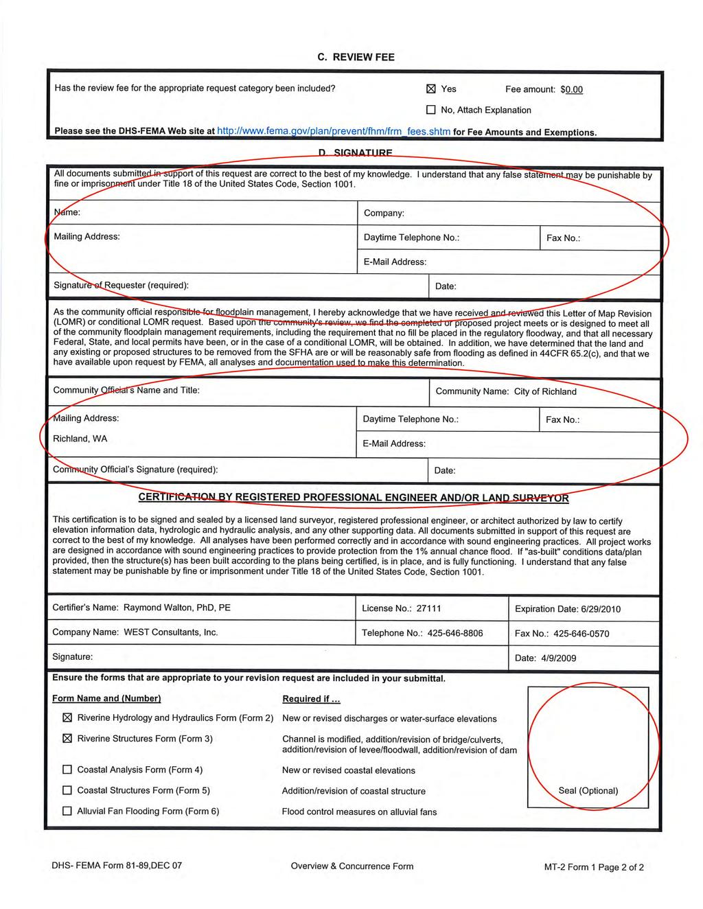
29 Appendix A: CLOMR Application 21
30 This page intentionally left blank for printing purposes. 22
31
32
33
34

35
36
37
38
39
40
41
42
43
44
45
46
47
48
49
50
51
52
53
54
55
56
57
58
59
60
61
62
63
64
65
66
67
68
69
70
71
72
73
74
75
76
77
78
79
80
81
82
83
84
85
86
87
88
89
90
91
92
93
94
95 Appendix B: Permits Required 87
96 This page left blank intentionally for printing purposes. 88
97 Permits Required for the Duportail Bridge Project Permit, Approvals and Concurrences NEPA Concurrence Wildlife, Aquatic Resources, and Vegetation Discipline Report Surface Water Discipline Report Geology and Soils Discipline Report 4(f) Discipline Report Visual Impacts Discipline Report Traffic Noise Discipline Report Public Services and Utilities Discipline Report Land Use Discipline Report Environmental Justice Discipline Report Section 7 Concurrence Activity Proposed Action will utilize federal funds, occur on federal lands, and require permit approvals from both the US Army Corps of Engineers and Federal Emergency Management Agency Agency Federal Highway Administration (lead), US Army Corps of Engineers, and Federal Emergency Management Agency US Fish and Wildlife, NOAA Fisheries Section 106 Concurrence Excavation of previously undisturbed areas Department of Archaeology and Historic Preservation Section 10 Permit Approval Regulates the construction of any structure in U S Army Corps of Engineers or over any navigable water of the United States Section 401 Water Quality Certification Required for discharges into waters of the US Ecology associated with the Section 10 permit SEPA Determination Proposed Action will utilize state funds City of Richland NPDES Permit Approval Stormwater Discharge Ecology Hydraulic Permit Approval Use, diversion, obstruction, or change the bed or flow of state waters Shoreline Permit Development within a designated shoreline of City of Richland the state Critical Areas Permit Project action will occur on/in habitat areas City of Richland associated with threatened, endangered, sensitive, or priority species Geologic Hazard Permit Earthwork and/or placement of a structure(s) City of Richland in or within 200 feet of a geologic hazard area Floodplain Development Permit Fill to be placed below the 100-year flood elevation City of Richland CLOMR Conditional Letter of Map Revision Federal Emergency Management Agency 89
98 This page left blank intentionally for printing purposes. 90
Land Use Discipline Report
 Land Use Discipline Report Duportail Street Bridge Project Benton County, Washington Prepared by: Federal Highway Administration 711 South Capitol Way, Suite 501 Olympia, WA 98501 Washington State Department
Appendix E Preliminary Location Hydraulic Study
 Appendix E Prepared for: State of Alaska Department of Transportation and Public Facilities Prepared by: HDR Alaska, Inc. 2525 C Street, Suite 305 Anchorage, Alaska 99503 February 2014 This page intentionally
Existing Conditions and Environmental Consequences Floodplains
 3.9 Environmental Consequences 3.8 3.8.1 WHAT ARE FLOODPLAINS? are low-lying areas adjacent to rivers, streams, and other waterbodies that are susceptible to inundation (flooding) during rain events. These
WELCOME! 8 8:30 6: TH STREET IMPROVEMENTS. Open House. Presentation & Q&A
 WELCOME! 168 TH STREET IMPROVEMENTS 6:30 Open House 7 8 Presentation & Q&A 8 8:30 Open House WELCOME Todd Pfitzer City of Omaha Engineer Bob Stubbe City of Omaha Public Works Director Jon Meyer Project
7.0 SOCIAL, ECONOMIC, AND ENVIRONMENTAL ISSUES
 7.0 SOCIAL, ECONOMIC, AND ENVIRONMENTAL ISSUES The following list of social, economic, and environmental issues have been identified based on a preliminary inventory of resources in the project area, an
Drexel, Barrell & Co.
 Drexel, Barrell & Co. December 21, 2018 Engineers/Surveyors Boulder Colorado Springs Greeley 3 South 7 th Street Colorado Springs, Colorado 80905-1501 719 260-0887 719 260-8352 Fax El Paso County Planning
Northern Branch Corridor DEIS December 2011
 16 Floodplains 161 Chapter Overview 1611 Introduction The flowing chapter identifies floodplains found within the Northern Branch Corridor in accordance with Executive Order 11988, Floodplain Management
Drexel, Barrell & Co.
 Drexel, Barrell & Co. June 18, 2018 Engineers/Surveyors Boulder Colorado Springs Greeley 3 South 7 th Street Colorado Springs, Colorado 80905-1501 719 260-0887 719 260-8352 Fax El Paso County Planning
Floodplain Technical Memorandum
 Southeast Extension Project Lincoln Station to RidgeGate Parkway Prepared for: Federal Transit Administration Prepared by: Denver Regional Transportation District May 2014 Table of Contents Page No. Chapter
CHECKLIST FOR PHASE II DRAINAGE REPORT
 I. COVER SHEET CHECKLIST FOR PHASE II DRAINAGE REPORT A. Name of Project B. Address C. Owner D. Developer E. Engineer F. Submittal date and revision dates as applicable II. GENERAL LOCATION AND DESCRIPTION
When planning stormwater management facilities, the following principles shall be applied where possible.
 2.0 Principles When planning stormwater management facilities, the following principles shall be applied where possible. 2.0.1 Drainage is a regional phenomenon that does not respect the boundaries between
HAZARD MITIGATION GOALS AND OBJECTIVES
 SEWRPC Community Assistance Planning Report No. 282, 2nd Edition CITY OF MILWAUKEE ALL HAZARDS MITIGATION PLAN UPDATE Chapter IV HAZARD MITIGATION GOALS AND OBJECTIVES [NOTE: Throughout this plan update
Your town s subdivision or land use ordinance standards should reference the following street standards, for example:
 Your town s subdivision or land use ordinance standards should reference the following street standards, for example: Streets shall be designed to move traffic safely and in a way that minimizes environmental
Level 1 Downstream Analysis
 Level 1 Downstream Analysis Newcastle Way Apartments Newcastle, Washington King County April 14, 2014 Revised July 10, 2014 Prepared by: Dean A. Furr, P.E. Reviewed by: Donald Scarberry, P.E. Coffman Engineering,
SECTION 5: REACH RECOMMENDATIONS/MAPS
 SECTION 5: REACH RECOMMENDATIONS/MAPS This section describes areas of concern and provides specific recommendations for each project reach. Locations of stormwater drains were from GIS coverage supplied
River Corridor Overlay Zone (RCOZ) Article 5
 Article 5") River Corridor Overlay Zone (RCOZ) Article 5 The site is in one of two designated districts. The first is the CBD (central business district) River District, which recognizes the urban character and unique
River Corridor Overlay Zone (RCOZ) Article 5 The site is in one of two designated districts. The first is the CBD (central business district) River District, which recognizes the urban character and unique
SECTION 4(f) DE MINIMIS DOCUMENTATION
 DE MINIMIS DOCUMENTATION") SECTION 4(f) DE MINIMIS DOCUMENTATION Illinois Route 60/83 IL 176 to the intersection of IL 60 (Townline Road) Lake County P-91-084-07 Mundelein Park and Recreation District Project Limit SECTION 4(f)
SECTION 4(f) DE MINIMIS DOCUMENTATION Illinois Route 60/83 IL 176 to the intersection of IL 60 (Townline Road) Lake County P-91-084-07 Mundelein Park and Recreation District Project Limit SECTION 4(f)
STREAM BUFFERS
 88-415 STREAM BUFFERS 88-415-01 PURPOSE In the Kansas City region and throughout the nation, vegetated stream buffers have been clearly shown to protect stream stability and related infrastructure, improve
Section 3 Non-Structural BMPs
 3.1 Stream Buffers A stream buffer or stream setback is a designated area around a stream, lake, or wetland left in a natural, densely vegetated state so as to protect the receiving water quality and provide
ENBRIDGE GAS DISTRIBUTION INC. Proposed Relocation for Ninth Line, Markham and Whitchurch-Stouffville. Environmental Screening Report
 Page 1 of 18 ENBRIDGE GAS DISTRIBUTION INC. Proposed Relocation for Ninth Line, Markham and Whitchurch-Stouffville Environmental Screening Report July 2011 Page 2 of 18 Table of Contents 1.0 INTRODUCTION
SUMMARY. Support the Southeast Arkansas Regional Intermodal Facility.
 SUMMARY THE I-69 LOCATION STUDY The proposed I-69 Location Study from El Dorado to McGehee, Arkansas, represents one section (Section of Independent Utility No. 13) of the nationally designated I-69 Corridor
Town of Vershire Road Erosion Inventory Report
 Town of Vershire Road Erosion Inventory Report Taylor Valley Road. Photo taken by TRORC staff. Prepared by: 128 King Farm Road Woodstock, VT 05091 Inventory and report funded by the Vermont Agency of Transportation
PROJECT BACKGROUND. Preliminary Design Scope and Tasks
 PROJECT BACKGROUND Preliminary Design Scope and Tasks The purpose of this Study is the development of preliminary designs for intersection improvements for Trunk Highway (TH) 36 at the intersections of
Lower Don River West Remedial Flood Protection Project TABLE OF CONTENTS. Page. Executive Summary
 TABLE OF CONTENTS Page Executive Summary 1.0 INTRODUCTION...1-1 1.1 Purpose of the Undertaking...1-1 1.2 Study Area Description...1-1 1.3 Description of the Undertaking...1-1 1.4 Rationale for the Undertaking...1-2
Chapter 8. Visualizations
 Examples of Effective Techniques for Improving the Quality of Environmental Documents Chapter 8. Visualizations Visualizations help the reader to see what the project would look like in the real world.
STORMWATER MANAGEMENT CODES ANALYSIS RICHLAND COUNTY, SC SITE PLANNING ROUNDTABLE
 STORMWATER MANAGEMENT CODES ANALYSIS RICHLAND COUNTY, SC SITE PLANNING ROUNDTABLE Codes analyses for each subcommittee were completed to assist participants of the Richland County Site Planning Roundtable.
MEMORANDUM. September 10, 2018
 September 10, 2018 MEMORANDUM TO: Chad Bird, City of Decorah FROM: Larry Weber and Dan Gilles, Iowa Flood Center, IIHR Hydroscience & Engineering COPY TO: Dana Werner, St. Paul District Corps of Engineers,
Poisoned Park? How Exide s Lead Contamination Risks Frisco s Grand Park
 Frisco City Hall has big plans to transform Stewart Creek into a Grand Park with lots of water features for kids to play in. Poisoned Park? How Exide s Lead Contamination Risks Frisco s Grand Park But
Transportation Improvements
 Transportation Improvements 0 0 Volume II of the Final EIS for the DHS Headquarters consolidation at St. Elizabeths includes analysis to transportation improvements for the DHS Headquarters Consolidation
Rule D Wetland and Creek Buffers
 Rule D Wetland and Creek Buffers 1 Policy It is the policy of the Board of Managers to ensure the preservation of the natural resources, recreational, habitat, water treatment and water storage functions
Chapter 5: Natural Resources and Environment
 NATURAL RESOURCES AND ENVIRONMENT 5-1 5 Chapter 5: Natural Resources and Environment BACKGROUND AND INTENT Urban expansion represents the greatest risk for the future degradation of existing natural areas,
City of Waco Stormwater Management Regulations
 1.0 Applicability: City of Waco Stormwater Management Regulations These regulations apply to all development within the limits of the City of Waco as well as to any subdivisions within the extra territorial
Public Visioning City of Kelso Planning Commission
 Shoreline Master Program Update Public Visioning City of Kelso Planning Commission November 13, 2012 Schedule Jurisdiction Inventory Analysis Visioning Topics Process Governing Principles Structure of
STORMWATER SITE PLAN INSTRUCTIONS AND SUBMITTAL TEMPLATE Medium and Large Projects
 DEPARTMENT OF COMMUNITY DEVELOPMENT 621 Sheridan Street, Port Townsend, WA 98368 Tel: 360.379.4450 Fax: 360.379.4451 Web: www.co.jefferson.wa.us/communitydevelopment E-mail: dcd@co.jefferson.wa.us STORMWATER
A. INTRODUCTION B. CUMULATIVE EFFECTS ANALYSIS
 Chapter 4: Cumulative Effects A. INTRODUCTION The New York City Department of Parks and Recreation plans to reconstruct the Rockaway Beach Boardwalk in the borough of Queens, New York City, which Hurricane
COLLIER BOULEVARD (CR 951) CORRIDOR
 CORRIDOR") Project(s) Goals Improve Traffic Circulation, Capacity & Safety Focus on Safety During Design & Construction Address Public Concerns Design an Aesthetically Pleasing Project Limit Environmental Impacts
Project(s) Goals Improve Traffic Circulation, Capacity & Safety Focus on Safety During Design & Construction Address Public Concerns Design an Aesthetically Pleasing Project Limit Environmental Impacts
Canyon Lake Master Plan Revision Public Information Meeting March 18, 2016
 Canyon Lake Master Plan Revision Public Information Meeting March 18, 2016 Marcus Schimank Canyon Lake Manager Capital Regional Office U.S. Army Corps of Engineers Fort Worth District US Army Corps of
Improving Communities Through the Arroyo Seco Sustainability Campaign and Watershed Assessment
 Improving Communities Through the Arroyo Seco Sustainability Campaign and Watershed Assessment Arroyo Seco Headwaters in the San Gabriel Mountains Major tributary to the Los Angeles River 44 square mile
Table of Contents G.1.a Water Resources - Surface Water - Drainage
 Table of Contents G.1.a Water Resources - Surface Water - Drainage 1. INTRODUCTION... 1335 2. ENVIRONMENTAL SETTING... 1335 a. Regional Hydrology... 1335 b. Local Hydrology... 1337 c. On-site Hydrology...
Mendota Heights 2040 Comprehensive Plan Draft Vers
 4 Parks and Trails The City of Mendota Heights boasts a variety of recreational and open space opportunities. Few cities can claim access to regional trails, riverside and lakeside parks, scenic bluffs
(blank page) WestConnex New M Roads and Maritime Services Environmental impact statement
 WestConnex New M Roads and Maritime Services Environmental impact statement") (blank page) WestConnex New M5 5-42 (blank page) WestConnex New M5 5-44 5.5 Tunnels 5.5.1 Main alignment tunnels The main alignment tunnels would be about nine kilometres long, with the western tunnel
(blank page) WestConnex New M5 5-42 (blank page) WestConnex New M5 5-44 5.5 Tunnels 5.5.1 Main alignment tunnels The main alignment tunnels would be about nine kilometres long, with the western tunnel
Chesapeake Bay Critical Area Conservation Plan
 The Maryland-National Capital Park and Planning Commission Prince George s County Planning Department Development Review Division 301-952-3530 Note: Staff reports can be accessed at www.mncppc.org/pgco/planning/plan.htm.
The Illinois Department of Transportation and Lake County Division of Transportation. Route 173, including the Millburn Bypass
 The Illinois Department of Transportation and Lake County Division of Transportation welcome you to this Public Hearing for U.S. Route 45 from Illinois Route 132 to Illinois Route 173, including the Millburn
PURPOSE: The purpose is to provide commercial facilities in the Vancouver and Clark County vicinity.
 US Army Corps of Engineers Seattle District Joint Public Notice Application for a Department of the Army Permit and a Washington Department of Ecology Water Quality Certification and/or Coastal Zone Management
SOUTHWEST CORRIDOR EXTENSION. Environmental Evaluation and Basic Engineering Results PUBLIC MEETING/OPEN HOUSE November 18, 2009
 SOUTHWEST CORRIDOR EXTENSION Environmental Evaluation and Basic Engineering Results PUBLIC MEETING/OPEN HOUSE November 18, 2009 AGENDA I. Welcome/Introductions II. Project Review and Status III. Environmental
Ashland BRT Environmental Assessment: logos of CTA, CDOT, Chicago Department of Housing and Economic Development
 Ashland BRT Environmental Assessment: logos of CTA, CDOT, Chicago Department of Housing and Economic Development Overview The Chicago Transit Authority (CTA), in partnership with the Chicago Department
Peoria Riverfront Development (Ecosystem Restoration) Upper Mid-sized Island Critical Restoration Project (September 2011)
 Upper Mid-sized Island Critical Restoration Project (September 2011)") Peoria Riverfront Development (Ecosystem Restoration) Upper Mid-sized Island Critical Restoration Project (September 2011) Description The Corps of Engineers, Rock Island District (District) and the Illinois
Peoria Riverfront Development (Ecosystem Restoration) Upper Mid-sized Island Critical Restoration Project (September 2011) Description The Corps of Engineers, Rock Island District (District) and the Illinois
Alternate Green Stream Bank Stabilization Methods
 U.S. Army Corps of Engineers Philadelphia/Baltimore Districts Alternate Green Stream Bank Stabilization Methods Wissahickon Creek, Tannery Run and Rose Valley Creek Bo-Rit Asbestos Site Ambler, Pennsylvania
3/7/2013. Compliance & Sustainability
 Overview www.kieser associates.com Celebrating 20 Years of Excellence in Environmental Science & Engineering WMU Arcadia Creek Stormwater Treatment and Floodplain Enhancement Project DEQ #2008 0018 and
DRAFT MAP AMENDMENT FLU 04-4
 DRAFT MAP AMENDMENT FLU 04-4 SW 24 TH AVENUE ROADWAY CORRIDOR The University of Florida participates with the Metropolitan Transportation Planning Organization (MTPO) in its responsibilities for the continuing,
Zoning Ordinance Article 3
 Article 3 Natural Resources Protection Section 301 Natural Resources Protection 301.1. Purpose - The following natural resources protection standards are established to protect the public health, safety
Information for File # JTF
 Information for File # 2013-04665-JTF Applicant Corps Contact Enbridge Energy, Limited Partnership Josh Fitzpatrick Address 1554 Highway 2, Suite 2, Two Harbors, MN 55616 E-Mail joshua.t.fitzpatrick@usace.army.mil
ADOPTED CAPITAL IMPROVEMENT PROGRAM BUDGET ARROYO PROJECTS
 ADOPTED CAPITAL IMPROVEMENT PROGRAM BUDGET ARROYO PROJECTS HAHAMONGNA FY 212-216 Capital Improvement Program Priority Description Total Estimated Costs Appropriated Through FY 211 Adopted FY 212 FY 213
OPPORTUNITIES AND CONSTRAINTS - OXBOW PARK ENTRANCE AND PUT-IN
 OPPORTUNITIES AT OXBOW EXISTING WETLANDS Site is undeveloped and we can design a park that works well from the start. SAND BEACH Potential to eliminate invasive species. DEBRIS (CONCRETE, OLD CARS) VEGETATION
Department of Community Development. Planning and Environmental Review Division Revised Notice of Preparation
 Department of Community Development Michael J. Penrose, Acting Director Divisions Building Permits & Inspection Code Enforcement County Engineering Economic Development & Marketing Planning & Environmental
CATEGORICAL EXCLUSION DETERMINATION I 435/I 35/K 10 INTERCHANGE (JOHNSON COUNTY GATEWAY)
") December 11, 2012 CATEGORICAL EXCLUSION DETERMINATION I 435/I 35/K 10 INTERCHANGE (JOHNSON COUNTY GATEWAY) Project Number: Kansas Department of Transportation (KDOT) Project No. 435-46 KA-1002-03 Route:
December 11, 2012 CATEGORICAL EXCLUSION DETERMINATION I 435/I 35/K 10 INTERCHANGE (JOHNSON COUNTY GATEWAY) Project Number: Kansas Department of Transportation (KDOT) Project No. 435-46 KA-1002-03 Route:
MUCKLESHOOT INDIAN TRIBE Fisheries Division nd Avenue SE. Auburn, Washington
 MUCKLESHOOT INDIAN TRIBE Fisheries Division 39015-172nd Avenue SE. Auburn, Washington 98092-9763 Phone: (253) 939-3311. Fax: (253) 931-0752 Mr. David Radabaugh Shoreline Planer W A Dept. of Ecology 3190
Technical Memorandum 5
 Technical Memorandum 5 Environmental Resources August 2015 PREPARED BY AECOM Table of Contents Introduction... 3 Natural Features... 6 Watersheds... 6 Rivers, Lakes, Creeks... 6 Wetlands... 8 Floodplains...
Chapter 3 Site Planning and Low Impact Development
 CHAPTER 3 Site Planning and Low Impact Development Chapter 3 Site Planning and Low Impact Development 3.0 Introduction The City of Charleston requires that major residential, large commercial (>1 acre),
Right-of-Way Acquisitions and Relocations Technical Memorandum
 Right-of-Way Acquisitions and Relocations Technical Memorandum Southeast Extension Project Lincoln Station to RidgeGate Parkway Prepared for: Federal Transit Administration Prepared by: Denver Regional
Riparian Buffer on the Bushkill Creek. Policies
 Riparian Buffer on the Bushkill Creek Riparian buffers provide numerous benefits to landowners and the community by protecting groundwater recharge areas, providing flood control, providing stormwater
FLOODPLAIN USE PERMIT APPLICATION COMMUNITY DEVELOPMENT DEPARTMENT W. Ten Mile Road Novi, MI (248)
") FLOODPLAIN USE PERMIT APPLICATION COMMUNITY DEVELOPMENT DEPARTMENT 45175 W. Ten Mile Road Novi, MI 48375 (248) 347-0415 Office Use Only Permit Number: Date Issued: Processed By: Type of Permit: Date: Project
FLOODPLAIN USE PERMIT APPLICATION COMMUNITY DEVELOPMENT DEPARTMENT 45175 W. Ten Mile Road Novi, MI 48375 (248) 347-0415 Office Use Only Permit Number: Date Issued: Processed By: Type of Permit: Date: Project
PennDOT. single spann lanes and 3- mayy need to be to accommodate. any bridge. addition to III. Date: CRP 07/27/2015 CRP.
 (10/27/14) PennDOT Section 106 Field Assessments and Finding Combined Early tification/finding? Yes Concurrence required or requested: Yes MPMS: 51507 ER# (if consultation with PHMC required) ): County:
Executive Committee Meeting Addendum. #7/15 July 3, :30 A.M. HEAD OFFICE, 101 EXCHANGE AVENUE, VAUGHAN Members:
 Executive Committee Meeting Addendum #7/15 July 3, 2015 9:30 A.M. HEAD OFFICE, 101 EXCHANGE AVENUE, VAUGHAN Members: Maria Augimeri Michael Di Biase David Barrow Ronald Chopowick Vincent Crisanti Glenn
ARLINGTON COUNTY, VIRGINIA. County Board Agenda Item Meeting of January 28, 2017 SUPPLEMENTAL REPORT
 ARLINGTON COUNTY, VIRGINIA County Board Agenda Item Meeting of January 28, 2017 SUPPLEMENTAL REPORT DATE: January 26, 2017 SUBJECT: The Virginia Department of Transportation s Transform I-66 Inside the
Concord, BRF-X-5099 (021), Draft Alternative Analysis
, Draft Alternative Analysis") THE CITY OF CONCORD in conjunction with the STATE OF NEW HAMPSHIRE, DEPARTMENT OF TRANSPORTATION BUREAU OF ENVIRONMENT and the FEDERAL HIGHWAY ADMINISTRATION Concord, BRF-X-5099 (021), 12004 Draft Alternative
THE CITY OF CONCORD in conjunction with the STATE OF NEW HAMPSHIRE, DEPARTMENT OF TRANSPORTATION BUREAU OF ENVIRONMENT and the FEDERAL HIGHWAY ADMINISTRATION Concord, BRF-X-5099 (021), 12004 Draft Alternative
STATE OF TENNESSEE DEPARTMENT OF TRANSPORTATION ENVIRONMENTAL DIVISION
 STATE OF TENNESSEE DEPARTMENT OF TRANSPORTATION ENVIRONMENTAL DIVISION Suite 900 - James K. Polk Building 505 Deaderick Street Nashville, Tennessee 37243-0334 MEMORANDUM TO: FROM: Files Joe W. Matlock,
Northern Branch Corridor SDEIS March 2017
 14. Water Quality 14.1. Chapter Overview 14.1.1. Introduction This section discusses changes to the potential for activities associated with the development and operation of the Preferred Alternative to
PROJECT UPDATE BON AIR ROAD BRIDGE REPLACEMENT AND MAGNOLIA AVENUE WATER QUALITY FACILITIES
 CITY OF LARKSPUR PROJECT UPDATE BON AIR ROAD BRIDGE REPLACEMENT AND MAGNOLIA AVENUE WATER QUALITY FACILITIES PRESENTED BY Julian Skinner Larkspur Public Works Director DATE July 13, 2016 Bon Air Bridge
I. DESCRIPTION OF PROPOSED ACTION... 1 A. General Description... 1 B. Historical Resume and Project Status... 2 C. Cost Estimates...
 PROJECT COMMITMENTS SUMMARY... S-1 1. Type of Action... S-1 2. Description of Action... S-1 3. Summary of Purpose and Need... S-1 4. Alternatives Considered... S-2 5. NCDOT Alternatives Carried Forward...
Project Study Report Equivalent The Old Road Widening SIX FLAGS MAGIC MOUNTAIN. On Street The Old Road Between Magic Mountain Pkwy And Turnberry Lane
 Project Study Report Equivalent The Old Road Widening SIX FLAGS MAGIC MOUNTAIN On Street The Old Road Between Magic Mountain Pkwy And Turnberry Lane On Street Henry Mayo Drive Between The Old Road And
STREAM BANK STABILIZATION THORPS MORTIMER RECREATION AREA Grandfather Ranger District SITE LOCATION & DRAINAGE AREA
 STREAM BANK STABILIZATION THORPS CREEK @ MORTIMER RECREATION AREA SITE LOCATION & DRAINAGE AREA SITE LOCATION Drainage Area = 1.14 sq. miles STREAM BANK STABILIZATION THORPS CREEK @ MORTIMER RECREATION
RESOLUTION NO. R Refining the route, profile and stations for the Downtown Redmond Link Extension
 RESOLUTION NO. R2018-32 Refining the route, profile and stations for the Downtown Redmond Link Extension MEETING: DATE: TYPE OF ACTION: STAFF CONTACT: Capital Committee Board PROPOSED ACTION 09/13/2018
Draft Rhode Island Stormwater Design and Installation Standards Manual
 Draft Rhode Island Stormwater Design and Installation Standards Manual Summary The May 2009 Public Review Draft version of the RI Stormwater Design and Installation Standards Manual consists of approximately
KYTC and NFIP: Bridging Floodplain Management and Design KAMM CONFERENCE AUGUST 25, 2015
 KYTC and NFIP: Bridging Floodplain Management and Design KAMM CONFERENCE AUGUST 25, 2015 KYTC STATEWIDE DRAINAGE DESIGN Provide Drainage Design Services on an as needed basis: Perform hydraulic analysis
VALLEY COUNTY MINIMUM STANDARDS FOR PRIVATE ROAD DESIGN AND CONSTRUCTION
 MINIMUM STANDARDS FOR PRIVATE ROAD DESIGN AND CONSTRUCTION Adopted November 28, 2005 TABLE OF CONTENTS DEFINITION OF TERMS...II I. DESIGN CRITERIA... 1 A. GENERAL DESIGN CRITERIA... 1 B. ROADWAY CLASSIFICATION...
C. WATER. 1. Surface Water Runoff. See Section C.3, Flood Hazard/Mudflow Hazard, page Ground Water
 C. WATER 1. Surface Water Runoff See Section C.3, Flood Hazard/Mudflow Hazard, page 67. 2. Ground Water Determined not significant by the October 1984 and January 1999 Initial Studies conducted by the
Alignment Alternatives Study Supplemental Report
 Alignment Alternatives Study Supplemental Report East West Corridor Project Submitted to Yakima County Department of Public Services Yakima, Washington Alignment Alternatives Study Supplemental Report
STREAM ALTERATION PRACTICES
 STREAM ALTERATION PRACTICES Stream Diversion Channel SDC DEFINITION A temporary channel constructed to convey stream flow around in-stream construction. PURPOSE Stream diversion channels are used to allow
AESTHETIC APPEARANCE. Design Guidelines for Grade-Separated Pedestrian, Cyclist and Equestrian Structures
 III. AESTHETIC APPEARANCE The aesthetic qualities of a grade-separated structure are as important as the specific design criteria. For example, a structure may be constructed to the exact criteria set
City of Meriden Harbor Brook Flood Control Project Overview
 City of Meriden Harbor Brook Flood Control Project Overview Updated August 2013 OVERVIEW The center of Meriden, including the HUB site is the low point of the town which is ringed by basalt ridges. Running
Chapter 1 GENERAL SOUTH DAKOTA DRAINAGE MANUAL
 Chapter 1 GENERAL SOUTH DAKOTA DRAINAGE MANUAL October 2011 Table of Contents Section Page 1.1 INTRODUCTION...1-1 1.2 BASIC APPROACH...1-2 1.3 FUNCTIONAL RESPONSIBILITIES...1-3 1.3.1 Office of Road Design...1-3
Advance Engineering & Surveying PLLC
 Advance Engineering & Surveying, PLLC Consulting in: Civil & Environmental Engineering Land Surveying Land Development 11 Herbert Drive Phone: (518) 698-3772 Latham, N.Y. 12110 Email:ncostape@gmail.com
LOUISIANA STATE UNIVERSITY COMPREHENSIVE & STRATEGIC CAMPUS MASTER PLAN. APPENDIX G - Stormwater Study Findings & Stormwater Solutions
 LOUISIANA STATE UNIVERSITY COMPREHENSIVE & STRATEGIC CAMPUS MASTER PLAN APPENDIX G - Stormwater Study Findings & Stormwater Solutions LSU: MP Narrative July 2017 3.5 Open Space Existing Conditions The
Issues Requiring Future Study
 Issues Requiring Future Study Transportation planning is an ongoing process that tends to identify new issues as it finds solutions for others. Some issues are so complex that a solution to one problem
Mitchell Ranch South MPUD Application for Master Planned Unit Development Approval Project Narrative. Introduction
 Mitchell Ranch South MPUD Application for Master Planned Unit Development Approval Project Narrative Introduction Mitchell Ranch South is a proposed single family (detached) residential development on
Fall 2017 Construction Update
 Fall 2017 Construction Update Ward 4 Southeast Engineering Department Riverwalk Red Multi-Use Trail Bridge Rehabilitation The Riverwalk Red Multi Use Trail Bridge was awarded to Cramer and Associates,
Understanding Drainage Options What s Feasible and Legal. February 2019
 Understanding Drainage Options What s Feasible and Legal February 2019 Outline for the Presentation Do you need a permit? Does common law apply? Does local government approve it? Will my neighbor allow
Lincoln 270. City of Lincoln. Stormwater Management Plan. April 2, 2013
 Lincoln 270 City of Lincoln Stormwater Management Plan April 2, 2013 # 2005.48 Prepared By: Civil Engineering Solutions, Inc. 590 E Street Lincoln, Ca 95648 (916) 645 5700 1.0 Background: The project site
North Metro Natural Gas Pipeline Project Routing Study. Exhibit I: Comment and Response Document
 North Metro Natural Gas Pipeline Project Routing Study Exhibit I: Comment and Response Document North Metro Natural Gas Pipeline Project Routing Study This page intentionally left blank. North Metro Natural
Jill Stachura STORMWATER BMP AND STREAM RESTORATION IN A CITY PARK. October 2013 Southeast Stormwater Association Annual Conference, Charlotte, NC
 Jill Stachura STORMWATER BMP AND STREAM RESTORATION IN A CITY PARK October 2013 Southeast Stormwater Association Annual Conference, Charlotte, NC Project Location Gwinnett County, GA: Population: 825,000
WELCOME TO OPEN HOUSE TWO November 28, 2018
 Langstaff Road Weston Road to Highway 7 Class Environmental Assessment Study WELCOME TO OPEN HOUSE TWO November 28, 2018 Please sign in and join our mailing list Study Overview York Region is conducting
Clay Street Bridge Replacement Project
 Clay Street Bridge Replacement Project Frequently Asked Questions (FAQs) No. 2 April 4, 2018 The project is located in downtown Placerville on Clay Street between US Highway 50 and Main Street and Cedar
PARK CITY MUNICIPAL CODE TABLE OF CONTENTS TITLE 15 LAND MANAGEMENT CODE - CHAPTER 2.21
 PARK CITY MUNICIPAL CODE TABLE OF CONTENTS TITLE 15 LAND MANAGEMENT CODE - CHAPTER 2.21 TITLE 15 - LAND MANAGEMENT CODE CHAPTER 2.21 - SENSITIVE LAND OVERLAY ZONE (SLO) REGULATIONS 15-2.21-1. PURPOSE...1
ALTERNATIVES. NCDOT made an early decision to first determine how to build the project (construction method) followed by what to build (alternatives).
 followed by what to build (alternatives).") III. ALTERNATIVES A. CONSTRUCTION METHOD ALTERNATIVES NCDOT made an early decision to first determine how to build the project (construction method) followed by what to build (alternatives). One of the
III. ALTERNATIVES A. CONSTRUCTION METHOD ALTERNATIVES NCDOT made an early decision to first determine how to build the project (construction method) followed by what to build (alternatives). One of the
Shelbyville, KY Stormwater Best Management Practices. Section 2 EROSION PREVENTION AND SEDIMENT CONTROL PLAN
 Section 2 EROSION PREVENTION AND SEDIMENT CONTROL PLAN 2.1 Requirements The City of Shelbyville, KY will require an Erosion Prevention and Sediment Control (EPSC) Plan for most types of development construction.
STATUS REPORT ENVIRONMENTAL REVIEW FOR IMPROVED ACCESS. at the NORTH WHITE PLAINS STATION
 STATUS REPORT ENVIRONMENTAL REVIEW FOR IMPROVED ACCESS at the NORTH WHITE PLAINS STATION May 2009 Status Report- Environmental Review for Improved Access at the North White Plains Station A. INTRODUCTION
B. DESCRIPTION OF THE PROPOSED ACTION
 Executive Summary A. INTRODUCTION Metro-North Commuter Railroad Company ( Metro-North or the Project Sponsor ) is proposing the construction of a new, expanded parking garage at 50 Haarlem Avenue (formerly
PROJECT SCOPE OF WORK CITY OF TOWN AND COUNTRY STORMWATER PROGRAM
 PROJECT SCOPE OF WORK CITY OF TOWN AND COUNTRY STORMWATER PROGRAM Project ID Number: 25-5 Problem: Stormwater collected from the neighborhood upstream is released at 9 Muirfield Lane and flows west toward
FURNEAUX CREEK 5 CHANNEL
 FURNEAUX CREEK 5 CHANNEL AND TRAIL IMPROVEMENTS TEXAS CHAPTER AMERICAN PUBLIC WORKS ASSOCIATION PROJECT OF THE YEAR CATEGORY: ENVIRONMENT PROJECT OF $2 MILLION BUT LESS THAN $5 MILLION ENGINEERING DEPARTMENT,