Peoria Riverfront Development (Ecosystem Restoration) Upper Mid-sized Island Critical Restoration Project (September 2011)
|
|
|
- Nicholas Webster
- 5 years ago
- Views:
Transcription
 completed the feasibility study phase of the Peoria Riverfront Project (Project) in 2003; the Planning, Engineering, and Design Phase was initiated")
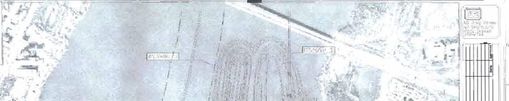
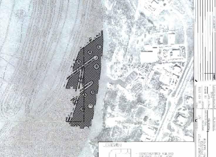
1 Peoria Riverfront Development (Ecosystem Restoration) Upper Mid-sized Island Critical Restoration Project (September 2011) Description The Corps of Engineers, Rock Island District (District) and the Illinois Department of Natural Resources (IL DNR) completed the feasibility study phase of the Peoria Riverfront Project (Project) in 2003; the Planning, Engineering, and Design Phase was initiated in January 2004 following receipt of State of Illinois funds. The principal goals of the Project are to improve depth diversity and enhance aquatic habitat in Peoria Lake. The recommended plan includes dredging approximately 200 acres within Lower Peoria Lake to create deepwater habitats and constructing three islands with a total area of 75 acres. In September 2004, approval was given to construct the Upper Mid-sized Island (55 acres of dredging with a 21-acre island) as a Critical Restoration Project under the Illinois River Basin Restoration Authority [Section 519, Water Resources Development Act (WRDA) 2000, as amended]. The State of Illinois provided construction funds in 2006 with Federal funds provided in late The WRDA of 2007 authorized the construction of the Lower Islands (145 acres of dredging with a 54-acre island). This Project initiated the construction phase of the Illinois River Basin Restoration Program. In November 2010, construction was completed on the Waubonsie Creek Fish Passage Critical Restoration Project in Kane and Kendall Counties. Fourteen additional Critical Restoration Projects are in various stages of planning and design, including two projects waiting construction at Pekin Lake. Section 519 of WRDA 2000 authorized: (1) a Comprehensive Plan to develop and implement a restoration program and a long-term resource monitoring program, and to evaluate new technologies and innovative approaches; and (2) construction of critical restoration projects. These efforts relate to the state's Illinois Rivers 2020 initiative, a proposed 20-year Federal/State effort to restore and enhance the 30,000 square-mile Illinois River Basin. The Comprehensive Plan was approved by HQUSACE in May 2007 and forwarded to Congress. History/Significance Peoria Lake, the largest bottomland lake in the Illinois River valley, reflects changes similar to other lakes. There are 60 backwater lakes along the Illinois River. The Illinois State Water Survey has estimated that average volumetric loss due to sedimentation of all backwater lakes since 1903 is 70%, with several approaching 100% loss. The oldest complete survey of the Illinois River system was done in This loss of aquatic habitat is viewed as the greatest threat to the Illinois River as concluded through a state-wide planning process that resulted in the Integrated Management Plan for the Illinois River in Since 1903, the volume of Peoria Lake below elevation 440 feet has decreased by approximately 61%. Elevation 440 is considered flat pool for Peoria Lake. The elevation is a function of the height of Peoria Lock and Dam. Areas
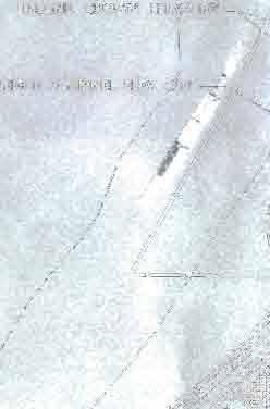
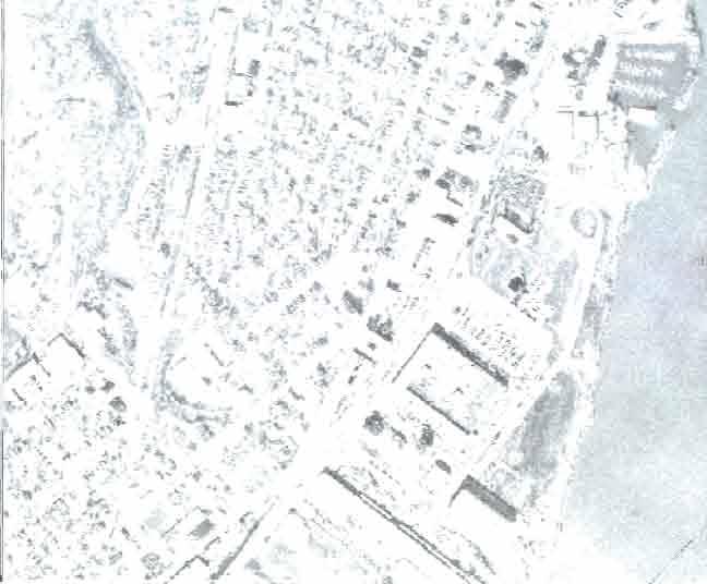
2 outside of the navigation channel have experienced sedimentation that is even more rapid. The loss of backwater lake depth and volume has severely impacted off-channel overwintering, spawning, and nursery habitats for fish. Shallow water areas are subject to wave action that re-suspends sediment, further limiting fish, aquatic vegetation, macro invertebrate, and mussel production. In Peoria Lake, sedimentation has resulted in the loss of deeper, off-channel parts of the lake from an estimated maximum of 8 feet to 1 to 2 feet in recent years. Off-channel areas will remain shallow and subject to re-suspension of sediment by waves if no action is taken. This transformation of Peoria Lake into a narrow navigation channel with bordering shallow, wind-swept areas will negatively impact fish and wildlife habitat and also reduce aesthetic values and recreation opportunities. Project Timeline United States House of Representatives Resolution 2500 of the Committee on Transportation and Infrastructure requests a feasibility study of the Peoria Lake area A Section 905(b) Reconnaissance Report is completed which recommends a feasibility study to assess measures to reduce existing sedimentation in Peoria Lake to create and restore aquatic habitats and reduce future sediment deposition in the Farm Creek Delta. May 2000 A study newsletter notifying residents of the study s initiation and upcoming open house was mailed to nearly 700 addresses. June 2000 A public open house was held in Peoria to execute the Feasibility Cost Sharing Agreement between the IL DNR and the District. The IL DNR and the District provided Study information to the 70 members of the public who attended the open house. November A study newsletter was mailed to over 700 addresses providing study background, purpose, a study update, a summary of the June open house, and an invitation to a November 29, 2000 Open House. The November Open House was held in Peoria with information regarding the study made available to 72 attendees June A study newsletter was mailed to over 800 addresses announcing a public meeting to present the study results to the public. The public meeting was held in Peoria with 77 people attending. December 2002 Statement of Findings and Findings of No Significant Impact signed. July 2003 The Report of the Chief of Engineers is signed. April 25, 2006 A Project Cooperation Agreement between the IL DNR and the Corps, Rock Island District for construction of the Upper Mid-sized Island Critical Restoration Project was executed. April 24, The public was invited to attend a ceremony held at the Peoria District Gateway Building to commemorate the initiation of construction and the contract award Construction The contract for the Peoria Riverfront Development, Illinois (Ecosystem Restoration) Upper Mid-sized Island Critical Restoration Project, Stage I was awarded March 2009 to Midwest Foundation Corporation of Tremont, Illinois for $3,528,320. Stage II was awarded in March 2010 to Midwest Foundation Corporation for $4,634,521. The dredging and island construction is currently taking place immediately north of the McClugage Bridge. Construction is anticipated to be complete in 2013.
3 Lower Island Design The District and the IL DNR signed a Design Agreement in July 2011 for the Two Lower Islands with Flowing Side Channel. Approximately two-thirds of the funds necessary for the design effort have been provided by Congress. If the remaining funds are provided, design efforts could be completed by the summer of Construction will be subject to further appropriation of construction funds by Congress. Point of Contact U.S. Army Corps of Engineers Rock Island District Project Manager: Mr. Marshall B. Plumley Phone: Marshall.B.Plumley@usace.army.mil

 1 C-200 D")
")

 - OVERHEAD UTILITIES - BURIED GAS - BERM SLOPE - EROSION")


4 1 1 DREDGE CHANNEL EL LEGEND: SITE PLAN GE C-201 C 100 C-202 D ESS B STACKED GEOTEXTILE CONTAINER TEST SECTION GEOTEXTILE CONTAINER ALIGNMENT B DREDGE ALIGNMENT A C-200 A ION STONE PTION 4) 1 C-200 D E F G H FORM ISLAND PERIMETER WITH 3 ROWS OF GEOTEXTILE CONTAINERS PLACE BERM INSIDE GEOTEXTILE CONTAINER RING (OPTIONS 1 AND 2) APPROXIMATE LOCATION OF TIRE REEF - (OPTION 3) - DREDGE CHANNEL - NAVIGATION CHANNEL - GEOTEXTILE CONTAINER - WORK LIMITS - BURIED FIBER OPTIC (APPROX. LOCATION) - OVERHEAD UTILITIES - BURIED GAS - BERM SLOPE - EROSION PROTECTION STONE AND SCOUR APRON D E F G H Sheet of 14 7 Sheet Reference Number: PEORIA RIVERFRONT ECOSYSTEM DEVELOPMENT PROJECT STAGE I SITE PLAN U.S. ARMY ENGINEER DISTRICT CORPS OF ENGINEERS ROCK ISLAND, ILLINOIS Designed By: RSK Drawn By: SDB Checked By: TNH Reviewed By: HLA Date: 20NOV2008 Scale: AS SHOWN Project Code: PA07 Solicitation Number: W912EK-09-R Symbol AMENDMENT #6 - TEXT CHANGES Description Revisions 25FEB09 TNH/HLA Date Approved Rock Island District of Engineers US Army Corps
 BASE BID DREDGE ALIGNMENT A TO EL. 430.0 AND CONSTRUCT POTHOLES. (SEE C-101) - BACKWATER AREA 2 ND RS ED 103) BACKWATER AREA 1 OPTION A - DREDGE ALIGNMENT B TO EL. 430.0 AND CONSTRUCT POTHOLES. (SEE C-102) EXISTING CHANNEL.")
 OPTION F CONSTRUCT ROCK JETTIES (TYPICAL) (SEE C-104) OPTION B - DREDGE ALIGNMENT C TO EL. 430.")
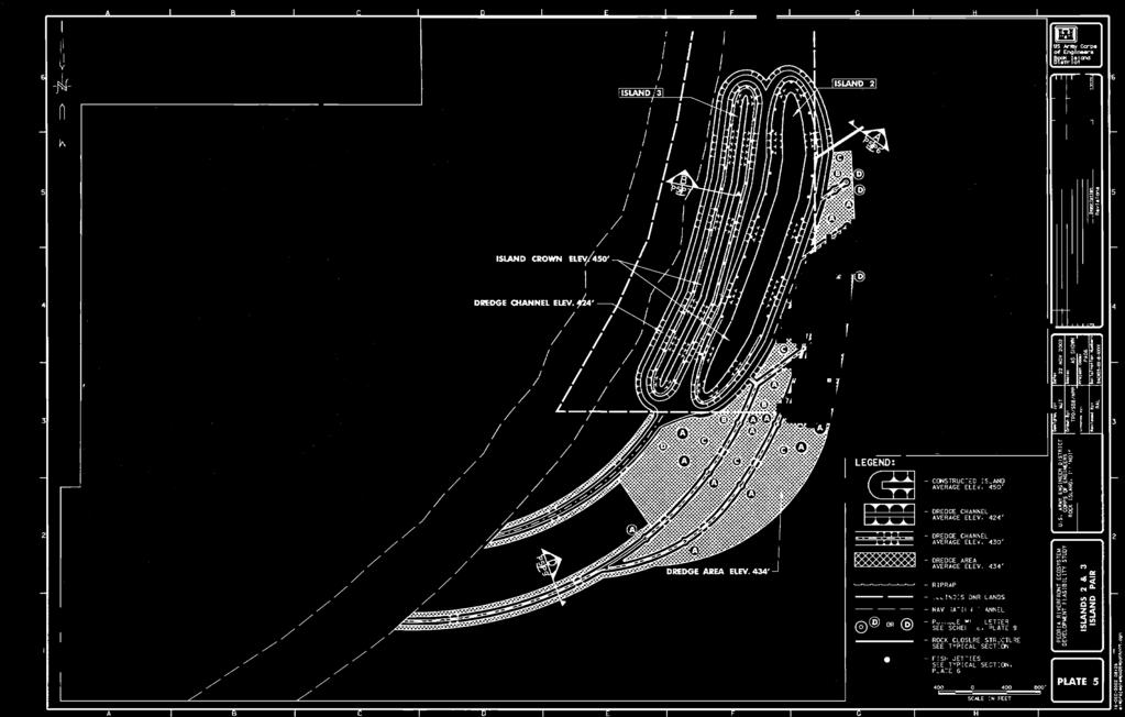
5 D E F G H SCALE IN FEET D E F G H (U.S. HIGHWAYS 24 AND 150) C C-301 B C-300 A C-300 OPTION G CONSTRUCT ROCK CLOSURE STRUCTURES (SEE C-104) OPTION E - DREDGE BACKWATER AREA 2 TO EL (SEE C-106) BASE BID DREDGE ALIGNMENT A TO EL AND CONSTRUCT POTHOLES. (SEE C-101) - BACKWATER AREA 2 ND RS ED 103) BACKWATER AREA 1 OPTION A - DREDGE ALIGNMENT B TO EL AND CONSTRUCT POTHOLES. (SEE C-102) EXISTING CHANNEL. (SEE C-300 AND C-301) APPROX. LOCATION OF EXISTING TIRE REEF (SEE C-104) OPTION D - DREDGE BACKWATER AREA 1 TO EL (SEE C-106) OPTION F CONSTRUCT ROCK JETTIES (TYPICAL) (SEE C-104) OPTION B - DREDGE ALIGNMENT C TO EL AND PLACE DREDGED MATERIAL ON INTERIOR OF ISLAND (SEE C-103) Sheet 9 of 22 Sheet Reference Number: ILLINOIS RIVER BASIN IL RIVER - RM TAZEW ELL COUNTY, IL PEORIA RIVERFRONT ISLAND SECTION 519, STAGE I SITE PLAN U.S. ARMY ENGINEER DISTRICT CORPS OF ENGINEERS ROCK ISLAND, ILLINOIS Designed By: TNH Drawn By: JMF Checked By: HLA Reviewed By: KNM Date: 2010/01/29 Scale: AS SHOW N Project Code: IW 112 Solicitation Number: W 912EK-10-R-0029 Symbol Description Date Approved Revisions Rock Island District US Army Corps of Engineers fi


6
BASS PONDS, MARSH, & WETLAND HABITAT RESTORATION PROJECT
 FACT SHEET BASS PONDS, MARSH, & WETLAND HABITAT RESTORATION PROJECT MINNESOTA VALLEY NATIONAL WILDLIFE REFUGE, MINNESOTA ENVIRONMENTAL MANAGEMENT PROGRAM LOCATION Three areas located on the Minnesota Valley
Longmeadow Parkway Fox River Bridge Corridor. August 6, 2015
 Longmeadow Parkway Fox River Bridge Corridor August 6, 2015 Longmeadow Parkway Bridge Corridor 5.6 miles from Huntley Road to IL 62 Unique municipal/county/state/federal partnership Links Randall Road
Pine Flat Lake Master Plan Update FACT SHEET September 2014
 Pine Flat Lake Master Plan Update FACT SHEET September 2014 PURPOSE AND OBJECTIVE The U.S. Army Corps of Engineers Sacramento District is revising the 1976 Pine Flat Lake Master Plan and is seeking public
Ashbridges Bay Erosion and Sediment Control Project
 Ashbridges Bay Erosion and Sediment Control Project Project Brief Overview Toronto and Region Conservation Authority, in partnership with the City of Toronto, intends to carry out remedial erosion control
Tentatively Selected Plan within Harlem River, East River and Western Long Island Sound Planning Region. First Level Costs. Federal Non-Federal Total
 HARLEM RIVER, EAST RIVER AND WESTERN LONG ISLAND SOUND PLANNING REGION Flushing Bay and Creek Ecosystem Restoration Source Feasibility Study Background Study Resolution (1994), Reconnaissance Report (1996),
Public Information Meeting
 Lavon Lake Master Plan Revision Public Information Meeting March 10, 2015 Presented By Michael Kinard Lake Manager U.S. Army Corps of Engineers Fort Worth District US Army Corps of Engineers Purpose of
The Napa River Flood Protection Project
 The Napa River Flood Protection Project Creating Flood Protection and Restoring Geomorphic and Biological Processes Jeremy Sarrow, Napa County Flood Control & Water Conservation District June 2, 2014.
River Mile 10.9 Removal Action Overview
 River Mile 10.9 Removal Action Overview November 13, 2014 CAG Meeting Modified from CPG s RM10.9 Removal Action Final Design Report dated Nov. 2013 1 River Mile 10.9 Removal Action Activities Dredging:
Joe Pool Lake Lake Master Plan Public Information Meeting Presentation of Final Draft Revision July 31, 2018
 Joe Pool Lake Lake Master Plan Public Information Meeting Presentation of Final Draft Revision July 31, 2018 Presented By Jeremy Spencer Lake Manager U.S. Army Corps of Engineers Fort Worth District US
Balancing Conservation and Development on the Jordan River
 Balancing Conservation and Development on the Jordan River Jordan River Parkway Trail Regional Athletic Complex Conservation & Restoration Balancing Conservation and Development on the Jordan River Jordan
Adaptive Management Strategies for Resilient Coastlines: A Case Study on the Ft. Pierce, FL Breakwater Project
 Adaptive Management Strategies for Resilient Coastlines: A Case Study on the Ft. Pierce, FL Breakwater Project USACE Workshop November 21 st, 2013 By: Jenna Phillips Emphasis on Green or Nature-Based Engineering
Department of Community Development. Planning and Environmental Review Division Revised Notice of Preparation
 Department of Community Development Michael J. Penrose, Acting Director Divisions Building Permits & Inspection Code Enforcement County Engineering Economic Development & Marketing Planning & Environmental
Improvement of the Atlantic Coast of New York City,
 Improvement of the Atlantic Coast of New York City, Rockaway Inlet to Norton Point Project at Sea Gate Meeting Purpose The U.S. Army Corps of Engineers, the New York State Department of Environmental Conservation,
LICENSES FOR UTILITY CROSSINGS OF PUBLIC LANDS AND WATERS ACCORDING TO MINNESOTA RULES CHAPTER [Rules Effective July 1, 2004]
![LICENSES FOR UTILITY CROSSINGS OF PUBLIC LANDS AND WATERS ACCORDING TO MINNESOTA RULES CHAPTER [Rules Effective July 1, 2004]](/thumbs/78/77546780.jpg "LICENSES FOR UTILITY CROSSINGS OF PUBLIC LANDS AND WATERS ACCORDING TO MINNESOTA RULES CHAPTER [Rules Effective July 1, 2004]") LICENSES FOR UTILITY CROSSINGS OF PUBLIC LANDS AND WATERS ACCORDING TO MINNESOTA RULES CHAPTER 6135 [Rules Effective July 1, 2004] Minnesota Department of Natural Resources Division of Lands and Minerals
LICENSES FOR UTILITY CROSSINGS OF PUBLIC LANDS AND WATERS ACCORDING TO MINNESOTA RULES CHAPTER 6135 [Rules Effective July 1, 2004] Minnesota Department of Natural Resources Division of Lands and Minerals
BEACH AND INLET PROJECTS UPDATE
 BEACH AND INLET PROJECTS UPDATE USACE DELTA PROJECT USACE Delta Project Project Extents Elevation Elevation (ft NAVD88) (ft NAVD88) USACE Delta Project Project Cross-Section 20 18 20 16 18 14 16 12 14
PURPOSE: The purpose is to provide commercial facilities in the Vancouver and Clark County vicinity.
 US Army Corps of Engineers Seattle District Joint Public Notice Application for a Department of the Army Permit and a Washington Department of Ecology Water Quality Certification and/or Coastal Zone Management
5 TH ANNUAL CAPE COASTAL CONFERENCE COONAMESSETT RIVER RESTORATION PROJECT. Elizabeth H. Gladfelter, Ph.D. Conservation Commission Town of Falmouth
 5 TH ANNUAL CAPE COASTAL CONFERENCE COONAMESSETT RIVER RESTORATION PROJECT Elizabeth H. Gladfelter, Ph.D. Conservation Commission Town of Falmouth Mural by Teaticket Elementary School 2 nd graders, Spring
STREAM BANK STABILIZATION THORPS MORTIMER RECREATION AREA Grandfather Ranger District SITE LOCATION & DRAINAGE AREA
 STREAM BANK STABILIZATION THORPS CREEK @ MORTIMER RECREATION AREA SITE LOCATION & DRAINAGE AREA SITE LOCATION Drainage Area = 1.14 sq. miles STREAM BANK STABILIZATION THORPS CREEK @ MORTIMER RECREATION
Introduction to the Seahurst Park Ecosystem Restoration Project: A Process of Transformation. Presented by Peter Hummel, ASLA, LEED AP
 Introduction to the Seahurst Park Ecosystem Restoration Project: Presented by Peter Hummel, ASLA, LEED AP September 16, 2014 Environmental Science Center Public Education Series 0 Acknowledgements Project
Vaughan Metropolitan Centre (VMC) Black Creek Renewal CLASS ENVIRONMENTAL ASSESSMENT
 Black Creek Renewal CLASS ENVIRONMENTAL ASSESSMENT") PUBLIC INFORMATION CENTRE Vaughan Metropolitan Centre (VMC) Black Creek Renewal Wednesday, May 10, 2017 6:00 p.m. to 8:00 p.m. Add photo Project Management, Environmental Assessment, Stormwater Management
PUBLIC INFORMATION CENTRE Vaughan Metropolitan Centre (VMC) Black Creek Renewal Wednesday, May 10, 2017 6:00 p.m. to 8:00 p.m. Add photo Project Management, Environmental Assessment, Stormwater Management
Lewisville Lake Master Plan Revision Public Information Meeting May 2 & 4, 2017
 Lewisville Lake Master Plan Revision Public Information Meeting May 2 & 4, 2017 Presented By Rob Jordan Lake Manager U.S. Army Corps of Engineers Fort Worth District US Army Corps of Engineers Purpose
GATEWAY BUILDING ELEVATOR AND ESCALATOR SERVICES
 29 One Gateway Plaza Los Angeles, CA 90012-2952 213.922.2000 Tel metro.net SYSTEM SAFETY AND OPERATIONS COMMITTEE JANUARY 16, 2014 SUBJECT: ACTION: GATEWAY BUILDING ELEVATOR AND ESCALATOR SERVICES APPROVE
Chapter PROJECT AUTHORIZATIONS
 Chapter 1 1.1. PROJECT AUTHORIZATIONS The Mississippi River Nine-Foot Channel Navigation Project was originally authorized by the River and Harbor Act of 1930 (Seventy-First Congress, Session 2, Chapter
VALLEY VIEW POND Q&A. This item will be discussed under the First Reading portion of the agenda at the July 17, 2012 Village Council meeting.
 VALLEY VIEW POND Q&A This item will be discussed under the First Reading portion of the agenda at the July 17, 2012 Village Council meeting. 1. Please provide a history of the pond including Village maintenance
Pittsburgh District Pittsburgh, PA Notice No Closing Date: May 29, 2015
 Public Notice U.S. Army Corps In Reply Refer to US Army Corps of Engineers, Pittsburgh District of Engineers Notice No. below 1000 Liberty Avenue Pittsburgh District Pittsburgh, PA 15222-4186 Application
PUBLIC SPACE/AMENITY PROJECTS
 BUFFALO S LWRP 49 A1. Black Rock Canal Park Improvements Erie County Parks Black Rock Canal Park, Ontario and Niagara Street intersection PROJECT DESCRIPTION: Erie County s Black Rock Canal Park is 4.25
Corridor Management Committee. September 29, 2017
 Corridor Management Committee September 29, 2017 1 Today s Topics Chair s Update Proposed Corridor Protection Wall Aesthetic Design Overview Public Outreach Environmental Review Civil Construction Update
SUMMARY. Support the Southeast Arkansas Regional Intermodal Facility.
 SUMMARY THE I-69 LOCATION STUDY The proposed I-69 Location Study from El Dorado to McGehee, Arkansas, represents one section (Section of Independent Utility No. 13) of the nationally designated I-69 Corridor
ANDERSON RIVER PARK SIDE CHANNEL HABITAT RESTORATION PROJECT. Public Outreach Meeting June 5, 2017
 ANDERSON RIVER PARK SIDE CHANNEL HABITAT RESTORATION PROJECT Public Outreach Meeting June 5, 2017 Welcome and Introductions Providing Feedback Anderson River Park is an important part of the community
12/7/2007. Christopher B. Burke Engineering West, Ltd Aux Sable Creek Watershed Plan Update 1
 The ABC s of BMP s Aux Sable Watershed Plan St. Charles, IL Why are BMP s Important Best Management Practices (BMPs) developed as a set of practices which help to achieve goals of the Clean Water Act and
Improving an Urban Watershed The Past, Present and Future of Addison Creek
 Improving an Urban Watershed The Past, Present and Future of Addison Creek IAFSM Conference March 14, 2018 Stormwater Management 1 Stormwater Management 2 PAST Reservoirs and Channel Improvements Stormwater
Nine Mile Creek Regional Trail Update. Edina City Council Workshop March 4, 2014
 Nine Mile Creek Regional Trail Update Edina City Council Workshop March 4, 2014 Presentation Outline: Where we ve been - Recap of route assessment process and approved route Where we are now - Summary
Canyon Lake Master Plan Revision Public Information Meeting March 18, 2016
 Canyon Lake Master Plan Revision Public Information Meeting March 18, 2016 Marcus Schimank Canyon Lake Manager Capital Regional Office U.S. Army Corps of Engineers Fort Worth District US Army Corps of
edmonton.ca/ribbonofgreen #ribbonofgreen
 WHAT IS THE RIBBON OF GREEN? The Ribbon of Green is Edmonton s entire river valley and ravine system. The Ribbon of Green (2018) Project will provide strategic guidance for the southwest and northeast
ADOPTED CAPITAL IMPROVEMENT PROGRAM BUDGET ARROYO PROJECTS
 ADOPTED CAPITAL IMPROVEMENT PROGRAM BUDGET ARROYO PROJECTS HAHAMONGNA FY 212-216 Capital Improvement Program Priority Description Total Estimated Costs Appropriated Through FY 211 Adopted FY 212 FY 213
Lake and Stream Restoration Project
 Pre-project Fact Sheet May 2012 Toledo Botanical Garden (TBG) is a 60 acre public garden visited by more than 120,000 people annually. It is located in Toledo, Ohio in the Ottawa River watershed within
Green Infrastructure. NYS Department of Environmental Conservation
 Green Infrastructure Green infrastructure is an interconnected network of natural areas and open spaces that sustains ecosystems. Benedict, M.A. and E.T. McMahon. 2006. Green Infrastructure Linking Landscapes
Pontchartrain Coastal Lines of Defense Program Figure 1 Figure 2 Figure 1
 Pontchartrain Coastal Lines of Defense Program Coastal Sustainability Program February 2006 The Pontchartrain Coastal Lines of Defense Program consists of ten priority project areas within the Pontchartrain
U.S. Army Corps of Engineers, Los Angeles District Prado Basin Project Updates
 U.S. Army Corps of Engineers, Los Angeles District Prado Basin Project Updates Host: Inland Empire Utilities Agency January 19, 2017 10:00 a.m. Purpose: To provide project overviews and updates to regional
OYSTER LAKE RESTORATION PROJECT
 Photo courtesy of Scott Jackson, PhotosFlorida. com Sarah Kalinoski, Choctawhatchee Basin Alliance OYSTER LAKE RESTORATION PROJECT OVERVIEW What? Where? Who? COASTAL DUNE LAKES Walton County, Florida Found
Enhance the High Line Canal Projects
 Enhance the High Line Canal Projects Joint Project Proposal for Arapahoe County Open Spaces Funding Partner Sponsors: South Suburban Park and Recreation District City of Centennial City of Littleton October
The Trinity River Corridor Project Update
 The Trinity River Corridor Project Update Councilmember Carolyn A. Davis Community Meeting October 14, 2008 The project covers 20 miles of the Trinity River, approx. 10,000 acres 2 Trinity River Corridor
7.0 SOCIAL, ECONOMIC, AND ENVIRONMENTAL ISSUES
 7.0 SOCIAL, ECONOMIC, AND ENVIRONMENTAL ISSUES The following list of social, economic, and environmental issues have been identified based on a preliminary inventory of resources in the project area, an
MPO UPDATE. Metro Advisory Committee. August 8, 2017
 MPO UPDATE Metro Advisory Committee August 8, 2017 Iowa Data Bike 1 2 3 4 Greater Des Moines Water Trails and Greenways Master Plan MPO Strategic Plan QUESTIONS? Photo Credit: Maharry Photograpy, 2014
Fall 2017 Construction Update
 Fall 2017 Construction Update Ward 4 Southeast Engineering Department Riverwalk Red Multi-Use Trail Bridge Rehabilitation The Riverwalk Red Multi Use Trail Bridge was awarded to Cramer and Associates,
2013 Summer Recap. Rockaway Beach
 2013 Summer Recap and Discussion on Rockaway Beach Reconstruction Tonight s Agenda Summer Beach Update Phase 2 Assumptions, Constraints and Regulations Rebuilding the Boardwalk Coastal Protection Rockaway
Grand River Ravines Georgetown Township
 Grand River Ravines Georgetown Township Project Description: The Grand River Ravines County Park property is composed of the 68-acre former Fillmore at the Bend Open Space purchased in 1999 and two more
4/8/2015 Item #10D Page 1
 MEETING DATE: April 8, 2015 PREPARED BY: Christy Villa, Associate Civil Engineer DEPT. DIRECTOR: Glenn Pruim DEPARTMENT: Public Works CITY MANAGER: Larry Watt SUBJECT: NORTH COAST HIGHWAY 101 STREETSCAPE
Shoreline Master Program Town of La Conner, Washington
 Shoreline Master Program Town of La Conner, Washington Department of Ecology approval effective Adopted September 24, 2013 by Town of La Conner Ordinance No.1106 Amended May 13, 2014 by Town of La Conner
Post Construction BMPs
 Post Construction BMPs Why are Post Construction BMPs important? With increased development brings the increase of impervious cover Parking lots, rooftops, driveways Storm water runoff volume increases
Town of Vershire Road Erosion Inventory Report
 Town of Vershire Road Erosion Inventory Report Taylor Valley Road. Photo taken by TRORC staff. Prepared by: 128 King Farm Road Woodstock, VT 05091 Inventory and report funded by the Vermont Agency of Transportation
FOR AGENCY MEETING OF: AGENDA ITEM NO.: URBAN RENEWAL AGENCY BOARD STEVEN POWERS, EXECUTIVE DIRECTO#
 FOR AGENCY MEETING OF: AGENDA ITEM NO.: March 14, 2016 4.2(a) TO: THROUGH: FROM: SUBJECT: URBAN RENEWAL AGENCY BOARD STEVEN POWERS, EXECUTIVE DIRECTO# KRISTIN RETHERFORD, DIRECTOR '!(/L/ URBAN DEVELOPMENT
Upper St. Croix & Eau Claire Rivers Watershed. Bony Lake
 Upper St. Croix & Eau Claire Rivers Watershed Bony Lake Bony Lake DNR Lake Protection - Project Partners: Grant Awarded July 2007 Bony Lake Residents-Grant Oversight Committee WI DNR Bayfield County LWCD
1.0 INTRODUCTION 1.1 TH 14 WEST STUDY AREA Project Description Functional Classification Purpose of the Project
 1.0 INTRODUCTION 1.1 TH 14 WEST STUDY AREA 1.1.1 Project Description The Trunk Highway (TH) 14 West Corridor is a two-lane roadway approximately 22 miles in length. Located in Nicollet County, the corridor
JOINT PUBLIC NOTICE. 26 June United States Army Corps of Engineers State of Louisiana
 JOINT PUBLIC NOTICE 26 June 2017 United States Army Corps of Engineers State of Louisiana New Orleans District Department of Environmental Quality Regulatory Branch Office of Environmental Services 7400
Middle Mississippi River. Regional Corridor
 Middle Mississippi River St. Louis District Regional Corridor Lessons Learned from a Collaborative Planning Study Brian Johnson US Army Corps of Engineers 12 th Biennial Governor s Conference on the Management
Joe Pool Lake Master Plan Revision Public Information Meeting May 23, 2017
 Joe Pool Lake Master Plan Revision Public Information Meeting May 23, 2017 Presented By Jason Owen Lake Manager U.S. Army Corps of Engineers Fort Worth District US Army Corps of Engineers Purpose of this
CHARLES COUNTY GOVERNMENT RFP NO POPES CREEK RAIL TRAIL DESIGN
 CHARLES COUNTY GOVERNMENT Department of Fiscal and Administrative Services Purchasing Division Telephone: 301-645-0656 July 7, 2015 RFP NO. 16-02 POPES CREEK RAIL TRAIL DESIGN ADDENDUM NUMBER ONE TO: All
ARROYO PROJECTS ADOPTED CAPITAL IMPROVEMENT PROGRAM BUDGET
 A RROYO P ROJECTS ADOPTED CAPITAL IMPROVEMENT PROGRAM BUDGET FISCAL YEARS 214-218 HAHAMONGNA Priority Description 1 Hahamongna Watershed Park - Implement Master Plan 211,6 211,6 (77565) 2 Hahamongna -
2014 HDR 2014 Architecture, HDR, Inc., all all rights reserved. reserved.
 2014 HDR 2014 Architecture, HDR, Inc., all all rights reserved. reserved. Uplift of a Wet Weather Stream: Satisfying Regulatory Requirements Agawela Drive Stream Project Chattanooga, TN 2014 HDR, Inc.,
1INTRODUCTION. Purpose of the Truckee Railyard Master Plan
 1INTRODUCTION Purpose of the Truckee Railyard Master Plan The purpose of the Truckee Railyard Master Plan is to capture and describe the Town s vision for the Railyard Area and to guide its future redevelopment.
Yadkin River Greenway Feasibility Study Fact Sheet Village of Clemmons, Town of Lewisville, Town of Bermuda Run
 Fact Sheet Village of Clemmons, Town of Lewisville, Town of Bermuda Run Project Background The Yadkin River Greenway Feasibility Study is a joint project with the Village of Clemmons, the Town of Bermuda
Once Upon a Gravel Pit: Reconnecting Floodplain through Aggregate Extraction
 Once Upon a Gravel Pit: Reconnecting Floodplain through Aggregate Extraction 5 th International Conference on Natural Channel Systems September 26, 2016 1 The Story of Snyder s Flats Historical influences
Town of Lyons Parks Flood Recovery Planning Process. Photograph courtesy of Ed Bruder
 Town of Lyons Parks Flood Recovery Planning Process Photograph courtesy of Ed Bruder Lyons Parks and Recreation Flood Recovery Update 1. Meadow Park Phase II - Project PW20B1 Estimated Completion: Summer
Town of Peru Comprehensive Plan Executive Summary
 Town of Peru Comprehensive Plan Executive Communities that plan grow by choice, not by chance. A plan makes growth thoughtful, understandable, and predictable. A plan shows that a community is managing
Iowa 100 Extension Project Visualizations for Design and Public Involvement ASCE Transportation Conference November 6, 2013 Ames, Iowa
 Iowa 100 Extension Project Visualizations for Design and Public Involvement 2013 ASCE Transportation Conference November 6, 2013 Ames, Iowa Agenda Project Corridor Constraints Key Features Project History
Constructed Stormwater Wetlands
 Types: Shallow Marsh System, Basin/Wetland System, Extended Detention Wetland, Pocket Wetland F. X. Browne, Inc., Lansdale, PA http://www.fxbrowne.com/html/fxb%20wetland%20cs/fxbi_constructed%20wetland_cs.htm
Mississippi Skyway Preliminary Engineering Report
 EXECUTIVE SUMMARY Mississippi Skyway Preliminary Engineering Report CITY OF RAMSEY, MINNESOTA DECEMBER 2014 City of RAMSEY EXECUTIVE SUMMARY Project Need and Intent The Mississippi Skyway pedestrian bridge
PROPOSED DRAINAGE PATTERNS
 1121 1118.50 Basin Floor 1120 1119 0 N 100 200 PROPOSED DRAINAGE PATTERNS Deroiser Drive Riverwood Drive County 260 0 100 200 Project Name: Riverwood Drive LITTLE FALLS TOWNHOMES Project Location: LITTLE
Louisiana Lawmakers Approve Historic Hurricane Protection Plan
 Louisiana Lawmakers Approve Historic Hurricane Protection Plan BATON ROUGE, Louisiana, June 1, 2007 (ENS) - The Louisiana Legislature has unanimously approved the state's first comprehensive master plan
Minot City Council -Special Meeting- Friday, July 21, :00 PM Minot City Council Chambers- City Hall
 Minot City Council -Special Meeting- Friday, July 21, 2017 12:00 PM Minot City Council Chambers- City Hall You are hereby notified pursuant to the authority vested in me as City Manager of the City of
RESPONSES TO PUBLIC CONCERNS AND QUESTIONS
 RESPONSES TO PUBLIC CONCERNS AND QUESTIONS Stations and Summary Questions for Public Meeting #2 June 23, 2015 General Questions / Concerns: 1. Is there any way this development can raise revenue for the
Coastal Planning in Texas. Tony Williams Senior Director of Planning Coastal Resources Division Texas General Land Office
 Coastal Planning in Texas Tony Williams Senior Director of Planning Coastal Resources Division Texas General Land Office e The Texas General Land Office (GLO) and the Texas Coast Since 1836: Manager of
Improving Communities Through the Arroyo Seco Sustainability Campaign and Watershed Assessment
 Improving Communities Through the Arroyo Seco Sustainability Campaign and Watershed Assessment Arroyo Seco Headwaters in the San Gabriel Mountains Major tributary to the Los Angeles River 44 square mile
REQUEST FOR QUALIFICATIONS
 REQUEST FOR QUALIFICATIONS for the City of Lake Forest Issue Date: September 23, 2015 Bid Due Date: October 19, 2015 The City of Lake Forest 800 N. Field Drive Lake Forest, Illinois 60045 THE CITY OF LAKE
Lake O the Pines Master Plan Revision Public Information Meeting April 25 & 27, 2017
 Lake O the Pines Master Plan Revision Public Information Meeting April 25 & 27, 2017 Presented By Matthew Like, Lake Manager U.S. Army Corps of Engineers Fort Worth District US Army Corps of Engineers
Urban Conservation Practice Physical Effects ESTABLISHMENT, GROWTH, AND HARVEST NUTRIENT MANAGEMENT
 NOT WELL 800 - Urban Stormwater Wetlands A constructed system of shallow pools that create growing conditions for wetland plants to lessen the impacts of stormwater quality and quantity in urban areas.
Lake Nokomis Shoreline Enhancement Project
 Lake Nokomis Shoreline Enhancement Project Community Meeting 2 February 13, 2018 Agenda Current Problems Project Goals Project Status Existing Conditions Community Input Draft Schematic Design Long-term
RESOLUTIO REGARDI G A THREE YEAR MOWI G SERVICES AGREEME T FOR THE HARTFORD LA DFILL
 RESOLUTIO REGARDI G A THREE YEAR MOWI G SERVICES AGREEME T FOR THE HARTFORD LA DFILL RESOLVED: That the President is hereby authorized to execute an agreement with Earthcare Service to provide mowing services
Farmers Investment Co. (FICO) Continental Farms
 Continental Farms") Farmers Investment Co. (FICO) Continental Farms Planning & Zoning Commission Study Session (River Master Plan) January 25, 2012 FICO Property 7,000 acres total area 6,000 acres in Town of Sahuarita 1,000
Farmers Investment Co. (FICO) Continental Farms Planning & Zoning Commission Study Session (River Master Plan) January 25, 2012 FICO Property 7,000 acres total area 6,000 acres in Town of Sahuarita 1,000
WELCOME! 8 8:30 6: TH STREET IMPROVEMENTS. Open House. Presentation & Q&A
 WELCOME! 168 TH STREET IMPROVEMENTS 6:30 Open House 7 8 Presentation & Q&A 8 8:30 Open House WELCOME Todd Pfitzer City of Omaha Engineer Bob Stubbe City of Omaha Public Works Director Jon Meyer Project
Chapter 5: Recreation
 Chapter 5: Recreation Introduction and Setting Recreational opportunities within Nevada County are varied, ranging from public parks with intensively used active recreational facilities, to vast tracts
Stream Restoration: Working with Nature?
 Stream Restoration: Working with Nature? Greg Jennings, PhD, PE jenningsenv@gmail.com Ecosystem Restoration activities that initiate or accelerate the recovery of ecosystem health, integrity, and sustainability
Stream Restoration: Working with Nature? Greg Jennings, PhD, PE
 Stream Restoration: Working with Nature? Greg Jennings, PhD, PE jenningsenv@gmail.com Ecosystem Restoration activities that initiate or accelerate the recovery of ecosystem health, integrity, and sustainability
Public Hearing. Charlotte County-Punta Gorda MPO - Meeting Rooms A and B March 14, open house at 4 p.m., formal presentation at 5 p.m.
 Public Hearing Charlotte County-Punta Gorda MPO - Meeting Rooms A and B March 14, 2019 open house at 4 p.m., formal presentation at 5 p.m. Welcome to the Public Hearing for the Harborview Road (CR 776)
Sconset Geotextile Tube Update Sconset Bluff, Nantucket. Maria Hartnett, Associate
 Sconset Geotextile Tube Update Sconset Bluff, Nantucket Maria Hartnett, Associate www.epsilonassociates.com Presentation Outline Project Setting & Need for Erosion Control Project Components Geotubes Sand
The Benefits and Challenges Associated with Green Infrastructure Practices
 The Benefits and Challenges Associated with Green Infrastructure Practices Thomas M. Evans ASLA, LEED AP Regional Green Infrastructure Design Services Director OWEA Technical Conference, June 20, 2013
Scarborough Waterfront Project
 Scarborough Waterfront Project Public Information Centre #1 Environmental Assessment Terms of Reference September 10, 2014 Agenda Open House Presentation 7:00 to 7:30 pm Presentation 7:30 to 8:15 pm History
APPENDIX I PUBLIC MEETING AT PROJECT INCEPTION
 APPENDIX I PUBLIC MEETING AT PROJECT INCEPTION OKLAHOMA DEPARTMENT OF TRANSPORTATION STATE HIGHWAY 10 ENVIRONMENTAL ASSESSMENT (MIAMI, OKLAHOMA) OPEN HOUSE SEPTEMBER 7, 2006 PROJECT OVERVIEW The Oklahoma
17 Jul 2002 PUBLIC NOTICE
 17 Jul 2002 Regulatory Branch PUBLIC NOTICE ------------- 1. Pursuant to Code of Federal Regulations 33 CFR 325.2(a)(8), the Chicago District issued permits or other approvals, withdrawals, appeals or
Information for File # ARC
 Information for File # 2016-02630-ARC Applicant Corps Contact Will Bomier-Carlton County Transportation Department Andrew R Chambers Address 600 South Lake Avenue, Suite 211, Duluth, MN 55802 E-Mail Andrew.R.Chambers@usace.army.mil
Transportation Committee
 Transportation Committee Business Item No. 2013-286SW Meeting date: October 14, 2013 For the Metropolitan Council meeting of October 16, 2013 Subject: Southwest Light Rail Transit (Green Line Extension):
City of Meriden Harbor Brook Flood Control Project Overview
 City of Meriden Harbor Brook Flood Control Project Overview Updated August 2013 OVERVIEW The center of Meriden, including the HUB site is the low point of the town which is ringed by basalt ridges. Running
Colorado Watershed Protection Fund - Project Grant Application Fountain Creek Restoration Shryver Park Reach Including Shryver Pond
 Fountain Creek - Manitou Springs, CO Shryver Park Reach and Pond Restoration Project Submitted by: The Fountain Creek Restoration Committee & The Pikes Peak Community Foundation April 28, 2008 FCRC Page
For personal use only
 15 December 2016 88 Energy Limited Acquisition of Rights to Secure Substantial Increase in Alaska Land Holding 88 Energy Limited ( 88 Energy, the Company ) (ASX, AIM: 88E) is pleased to announce the following
THE COMMUNITY-DRIVEN DESIGN PROCESS
 THE COMMUNITY-DRIVEN DESIGN PROCESS A PUBLIC DRIVEN PROCESS STEERING COMMITEE THE COMPREHENSIVE PLAN OPPORTUNITIES AND CONSTRAINTS THE COMMUNITY DRIVEN DESIGN PROCESS A Public Driven Process Beginning
Coffey Neighborhood Park Master Plan/Design/Rebuild Workshop. August 4, :00pm 4:00pm
 Coffey Neighborhood Park Master Plan/Design/Rebuild Workshop August 4, 2018 2:00pm 4:00pm 1 Agenda Welcome/Introductions Neighborhood Meeting Goals Master Planning Process Coffey Park Amenities (pre-fire
INTER-AGENCY COORDINATION MEETING
 Virginia Department of Transportation INTER-AGENCY COORDINATION MEETING Joint Permit Application DEQ COE VMRC I. VDOT PROJECT INFORMATION PERMIT #: PRE-APP#: Route: VDOT Project Number: City/County: Contract
OVERMOUNTAIN VICTORY TRAIL BURKE CALDELL CORRIDOR FEASIBLITY STUDY REQUEST FOR QUALIFICATIONS CALDWELL COUNTY PATHWAYS
 OVERMOUNTAIN VICTORY TRAIL BURKE CALDELL CORRIDOR FEASIBLITY STUDY REQUEST FOR QUALIFICATIONS CALDWELL COUNTY PATHWAYS Caldwell County Pathways along with our co-partners City of Lenoir, Town of Gamewell,
GREEN SHEET ENVIRONMENTAL COMMITMENTS FOR THE IOWA HIGHWAY 100 EXTENSION
 County: Linn County, IA GREEN SHEET Location: IA 100, from its terminus at Edgewood Rd. to US 30 southwest of Cedar Rapids Route: IA 100 Extension Project No.: NHS-100-1(36) 19-57 OLE Project Managers: