ANDERSON RIVER PARK SIDE CHANNEL HABITAT RESTORATION PROJECT. Public Outreach Meeting June 5, 2017
|
|
|
- Amanda Caitlin Dawson
- 6 years ago
- Views:
Transcription
1 ANDERSON RIVER PARK SIDE CHANNEL HABITAT RESTORATION PROJECT Public Outreach Meeting June 5, 2017

2 Welcome and Introductions
3 Providing Feedback Anderson River Park is an important part of the community and your input means a great deal to us. Discussion after presentation. Opportunity for written comments. Visit: to provide feedback online Contact us any time. Harmony Gugino Project Manager harmony@westernshastarcd.org, Jan Raether Project Coordinator jraether@westernshastarcd.org,
4 Agenda CVPIA Program Status of Shasta County Projects Guiding Principles for Planning Anderson River Park Side Channel Project Why Anderson River Park? Planning and Design Test Pit Activity Next Steps Feedback/Discussion
5 CVPIA Program - Overview Central Valley Project (CVP) is one of the world s largest water storage and conveyance systems and provides water supply to most of California. Central Valley Project Improvement Act (CVPIA) includes responsibility to establish programs for fish and wildlife restoration. Anadromous Fish Restoration Program (AFRP) focuses on restoration actions for salmon species in the Central Valley and Trinity River basins of California. CVPIA (b)(13) Spawning and Rearing Habitat Restoration Program focuses on the Stanislaus River, American River, and upper Sacramento River from Keswick Dam to former Red Bluff Diversion Dam.

6 Historically, endangered winter-run spawn in the uppermost reaches of the Sacramento River watershed. Dams cut off access to historic spawning and rearing areas and reduce watershed complexity. Complexity promotes salmon growth. Growth promotes survival. Historic Range for Salmon Runs Current Range for Salmon Runs

7 Status of Shasta County Projects Keswick Dam Gravel Market Street Gravel Painter s Riffle Channel/Gravel North Cypress Channel South Cypress Channel North Tobiasson Rearing Structures Shea Island Channel/Gravel Kapusta Side Channel Green = Completed Orange = In Progress Yellow = Planning Anderson River Park Channel
8 Guiding Principles for Planning Maximize benefit to endangered/ threatened salmonids Minimize disturbance/impacts Other benefits, where possible North Cypress Side Channel Project Example
9 Overhanging Vegetation Low Velocity, Ideal Depth Large Woody Debris
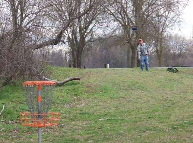
10 Guiding Principles for Planning Maximize benefit to endangered/ threatened salmonids Minimize disturbance/impacts Other benefits, where possible

11 Maintained Vegetation New Native Plantings Followed Path of Least Resistance
12 Guiding Principles for Planning Maximize benefit to endangered/threatened salmonids Minimize disturbance/impacts Additional benefits, where possible

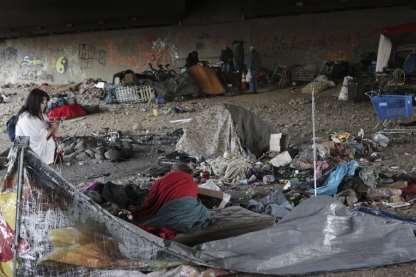
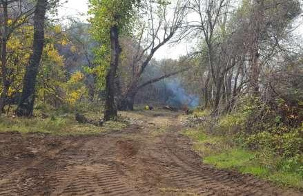
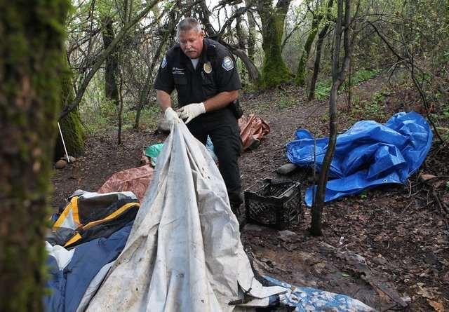
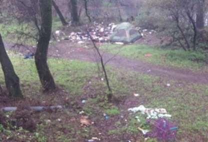
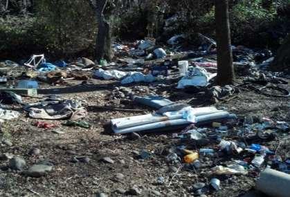
13 Clean-up & impede encampments Invasive species removal & improve access
14 Why Anderson River Park? Maximize benefit to endangered /threatened salmonids Working from north to south Upper 30% of the channel is disconnected. Well established riparian area. High-risk fish stranding site.


15 Years of Change 9/9/1998: 12,000 CFS 8/27/2013: 10,000 CFS Channel is clearly visible Channel is filled in

16 Stranding Locations During high flows, juvenile salmon are stranded in low-lying areas

17 Why Anderson River Park? Minimize disturbance/impacts Existing use for recreation and natural area are complementary land use.


18 Source: Record Searchlight Source: Record Searchlight Source: Shastadogs.com Source: Safe Haven Rescue Journal
19 Why Anderson River Park? Additional benefits Invasive species removal Potential reduction in stagnant backwaters conducive to mosquito reproduction Mapped trails/signage for public and emergency service
")
20 Number of mosquito larval treatments (2008-present)

21 Potential to create detailed trail map this map includes administrative, horse, and walking trails
22 Planning and Design Site recommendations Programmatic environmental assessment TAC review Site-specific resource surveys TAC review/land manager input Evaluate impacts (beneficial, negative) Test pit permits/approvals Outreach #1 Project permits/approvals Site recommendations Site inspections Conceptual design alternatives Engineering surveys 30% design/modeling (maximum habitat) 60% design/modeling Test pits 90% Design Construction

23 deeper low-lying areas + connection to backwaters + max suitable depth and velocity + large woody debris = 6 acres new juvenile rearing habitat
24 Test Pit Activity Purpose Predict amount of excavated material for channel construction Logistics Up to 9 pits (~2 w X 10 l X 10 d) Material piled next to pit using backhoe, replaced when completed Representative sample bagged, and tested offsite Up to two days beginning mid-july* Access along existing roads, trails and paths. Biological Monitors on site throughout excavation Impacts Noise during operation Minor temporary disturbance to soil and ground vegetation. *Permit allowing
25 Test Pit Locations

26 Test Pit Locations


27 Test Pit #1 Location: western side channel Vegetation: none WOUS: cobble/gravel riverine

28 Test Pit #2 Location: western side channel Vegetation: grasses WOUS: vegetated riverine

29 Test Pit #3 Location: adjacent to central side channel Vegetation: grasses WOUS: vegetated riverine

30 Test Pit #4 Location: central side channel Vegetation: grasses, willow WOUS: palustrine emergent persistent

31 Test Pit #5 Location: central side channel Vegetation: grasses WOUS: palustrine emergent persistent

32 Test Pit #6 Location: central side channel Vegetation: grasses WOUS: palustrine emergent persistent

33 Test Pit #7 Location: eastern side channel Vegetation: none WOUS: cobble/gravel riverine

34 Test Pit #8 Location: adjacent to eastern side channel Vegetation: grasses WOUS: cobble/gravel riverine


35 Test Pit #9 Location: eastern side channel Vegetation: grasses WOUS: palustrine emergent persistent
36 Next Steps Test Pit Excavation 90% Side Channel Design Access Mosquito/Vector Benefits Targeting stranding locations Outreach Meeting #2 (Late Summer) Side Channel Permits and Approvals Contractor Bids Construction (phases)
37 Thank you for your time. Questions? To provide feedback online visit:
38 Depth and Access
39 4,000 CFS (Minimal Flows) Post-Construction Conditions Channels are designed to be ~1.5 feet deep at these minimal allowable flows Pre-Construction Conditions Relatively dry access to all areas of the park

40 6,000 CFS (Typical Winter Flows) Post-Construction Conditions Channels are designed to be ~3 feet deep at these typical winter flows Pre-Construction Conditions Relatively dry access to all areas of the park
41 13,000 CFS (Typical Summer Flows) Post-Construction Conditions Channels are designed to be ~5 feet deep at these typical summer flows Pre-Construction Conditions The Island is almost entirely inaccessible without getting wet
42 Standard Channel Depth Cross Section: A 30 ft width Bank full Depth: 10ft 13,000 CFS Depth: 6ft 6,000 CFS Depth: 4ft 4,000 CFS Depth: 2ft The standard channel would have approximately 3:1 slopes, and be at least two feet deep at minimal flows to provide optimal fish habitat at reduced flows. Typical Summer Flows: 11,500 cfs Typical Winter Flows: 4,000 cfs
43 Shallow Water Crossings Cross Section: B 60 ft width Bank full Depth: 6ft 13,000 CFS Depth: 4ft 6,000 CFS Depth: 2ft 4,000 CFS Depth: 1ft In order to provide shallower depths, the shallow water crossings would be wider than other locations in the channel. This helps to maintain velocity and allows us to maintain suitable habitat above and below crossings. Typical Summer Flows: 11,500 cfs Typical Winter Flows: 4,000 cfs
44 Standard Channel Depth: 10 ft Minimum: 2 ft Cross Section: A Cross Section: B Standard Shallow Crossing Depth: 2-4 ft Minimum: 1 ft

45 Dry* Crossing at 14,000 CFS Dry* Crossing at 14,000 CFS Periodically Dry Crossing Dry Crossings indicate that you are likely to be stepping on rocks, or up to shin deep in standing, or slowly moving water. Periodically dry crossings indicate that these areas may be dry crossings at the lowest flows, but typically the water is too deep to cross Consistently Wetted Channel The consistently wetted channel is wet at all flows, and crossing without getting wet would be extremely difficult.


46 Types of Access Crossings Articulated blocks at low-flow crossing Portable bridge Permanent bridge
McArthur Swamp Planning Unit. Fish, Plant, and Wildlife Habitat MCARTHUR SWAMP PLANNING UNIT
 McArthur Swamp Planning Unit Fish, Plant, and Wildlife Habitat Conduct surveys of the planning unit to identify biological resources and enable their protection. Most of the McArthur Swamp land acreage
Is a Riparian Restoration Still Viable After 100-year Storm Events Alter the Original Design?
 Is a Riparian Restoration Still Viable After 100-year Storm Events Alter the Original Design? Sarah Spear Cooke, Ph.D. Seattle, Washington Presentation Outline Introduction The site pre-restoration Restoration
The Napa River Flood Protection Project
 The Napa River Flood Protection Project Creating Flood Protection and Restoring Geomorphic and Biological Processes Jeremy Sarrow, Napa County Flood Control & Water Conservation District June 2, 2014.
Section 3 Non-Structural BMPs
 3.1 Stream Buffers A stream buffer or stream setback is a designated area around a stream, lake, or wetland left in a natural, densely vegetated state so as to protect the receiving water quality and provide
Lake and Stream Restoration Project
 Pre-project Fact Sheet May 2012 Toledo Botanical Garden (TBG) is a 60 acre public garden visited by more than 120,000 people annually. It is located in Toledo, Ohio in the Ottawa River watershed within
Peoria Riverfront Development (Ecosystem Restoration) Upper Mid-sized Island Critical Restoration Project (September 2011)
 Upper Mid-sized Island Critical Restoration Project (September 2011)") Peoria Riverfront Development (Ecosystem Restoration) Upper Mid-sized Island Critical Restoration Project (September 2011) Description The Corps of Engineers, Rock Island District (District) and the Illinois
Peoria Riverfront Development (Ecosystem Restoration) Upper Mid-sized Island Critical Restoration Project (September 2011) Description The Corps of Engineers, Rock Island District (District) and the Illinois
Once Upon a Gravel Pit: Reconnecting Floodplain through Aggregate Extraction
 Once Upon a Gravel Pit: Reconnecting Floodplain through Aggregate Extraction 5 th International Conference on Natural Channel Systems September 26, 2016 1 The Story of Snyder s Flats Historical influences
Guiding Landowners in Stream Restoration. The Science, Practice & Art of Restoring Native Ecosystems 2015
 Guiding Landowners in Stream Restoration The Science, Practice & Art of Restoring Native Ecosystems 2015 January 24, 2015 Guiding Landowners in Stream Restoration January 24, 2015 Agenda 1Watershed Planning
Juneau Watershed Partnership
 Juneau Watershed Partnership Native Plant Resource Center Final Report A Partners for Fish and Wildlife Project Prepared for: U.S. Fish and Wildlife Service For Grant #F11C00552 Prepared by: The Juneau
North Branch of Cypress Creek Ecological Restoration: A Comprehensive Approach to Stream Restoration
 North Branch of Cypress Creek Ecological Restoration: A Comprehensive Approach to Stream Restoration Rocky Powell Clear Creeks Consulting, LLC Keith D. Tate, P.E. BayLand Consultants & Designers, Inc.
Post Construction BMPs
 Post Construction BMPs Why are Post Construction BMPs important? With increased development brings the increase of impervious cover Parking lots, rooftops, driveways Storm water runoff volume increases
PICTURE CANYON Planning Riparian-Wetland Refugia in an Urban Setting
 PICTURE CANYON Planning Riparian-Wetland Refugia in an Urban Setting Rio De Flag Existing Conditions. Ephemeral stream; Limited riparian plants, habitats.. & Opportunities Water (effluent) available Restore
Information for File MMJ Main Stem Bassett Creek Restoration Project
 Information for File 2013-03866-MMJ Main Stem Bassett Creek Restoration Project Applicant: Minneapolis Park and Recreation Board (MPRB) Corps Contact: Melissa Jenny Address: Corps of Engineers, St. Paul
Kootenai River Habitat Restoration Program June 18, 2018 Kootenai Valley Resource Initiative Update
 Kootenai River Habitat Restoration Program June 18, 2018 Kootenai Valley Resource Initiative Update Kootenai River Habitat Restoration Program Multi-year habitat restoration program Restoration treatments
Meeting Agenda. City of Guelph. River Systems Advisory Committee. Agenda Items. Item 1, 2 and 3. Item 4 Ward to Downtown Pedestrian Bridge
 Meeting Agenda City of Guelph River Systems Advisory Committee September 19, 2018 City Hall, Meeting Room B From 4:00 to 6:00 p.m. Meeting Chair: Mariette Pushkar Agenda Items Welcome to all Item 1, 2
April 11, 2016 Park Board Chair and Commissioners General Manager Vancouver Board of Parks and Recreation New Brighton Salt Marsh - Preferred Concept
 TO: FROM: SUBJECT: April 11, 2016 Park Board Chair and Commissioners General Manager Vancouver Board of Parks and Recreation New Brighton Salt Marsh - Preferred Concept RECOMMENDATION A. THAT the Vancouver
New Brighton Park Shoreline Habitat Restoration Project
 Vancouver Board of Parks and Recreation and Port Metro Vancouver New Brighton Park Shoreline Habitat Restoration Project Conceptual Design Public Consultation August 26 September 9, 2015 Discussion Paper
Improving Communities Through the Arroyo Seco Sustainability Campaign and Watershed Assessment
 Improving Communities Through the Arroyo Seco Sustainability Campaign and Watershed Assessment Arroyo Seco Headwaters in the San Gabriel Mountains Major tributary to the Los Angeles River 44 square mile
Don Narrows Workshop DRAFT MEETING REPORT Saturday, May 24, 2008 South Regent Park Recreation Centre
 Don Narrows Workshop DRAFT MEETING REPORT Saturday, May 24, 2008 South Regent Park Recreation Centre Introduction to the Workshop & this Report On Saturday, May 24, 2008 Toronto and Region Conservation
Cedar Niles Future Park Site Wetland #1
 Date: October 20, 2014 Site: Landowner: Johnson County Parks Designer: Thomas R. Biebighauser Individuals Present: Thomas R. Biebighauser, Dr. Eliodora Chamberlain (US EPA), Jason Daniels (US EPA), Jeannette
Planning for Staten. Habitat Restoration and Green Infrastructure. Island s North Shore
 Habitat Restoration and Green Infrastructure Planning for Staten Island s North Shore Community Board 1 March 1, 2018 NYC Parks Forestry, Horticulture, and Natural Resources Funded by the NYS Department
ADDENDUM TO BIOLOGICAL SCOPING SURVEY REPORT, BOTANICAL SURVEY AND WETLAND DELINEATION
 ADDENDUM TO BIOLOGICAL SCOPING SURVEY REPORT, BOTANICAL SURVEY AND WETLAND DELINEATION FOR AVALON INN (APN 069-241-27 & -04) 1201 & 1211 NORTH MAIN STREET FORT BRAGG, CA MENDOCINO COUNTY prepared for:
Chapter 3 Site Planning and Low Impact Development
 CHAPTER 3 Site Planning and Low Impact Development Chapter 3 Site Planning and Low Impact Development 3.0 Introduction The City of Charleston requires that major residential, large commercial (>1 acre),
APPENDIX C NATURAL RESOURCES MANAGEMENT PLAN: ACTIONS AND PRIORITIES
 APPENDIX C NATURAL RESOURCES MANAGEMENT PLAN: ACTIONS AND PRIORITIES TABLE C-1: Resource Actions and Priorities GOAL NRM-4 Objective 4.1: Restore Natural floodplain functions. Objective 4.2: Define and
Santa Cruz River Master Plan. Presented to the Arizona Floodplain Management Association Spring Conference June 8-10, 2011
 Santa Cruz River Master Plan Presented to the Arizona Floodplain Management Association Spring Conference June 8-10, 2011 Introduction Who is FICO? 2 Project Team Kimley-Horn and Associates, Inc. River
Department of Agriculture. Conservation Service. United States. Natural Resources REVISED 8/26/16
 GENERAL NOTES: SYMBOL LEGEND 1. All work shall comply with the constriction specifications, drawings, project-specific quality assurance plan and other contract requirements. 2. All notes on the drawings
Ecological Restoration at the Las Vegas Springs Preserve. Von K. Winkel, Ph.D.
 Ecological Restoration at the Las Vegas Springs Preserve Von K. Winkel, Ph.D. The Las Vegas Springs Before Disturbance The springs are very large. A small creek flows from each of 3 or 4 springs and
Homeowners Guide to Stormwater BMP Maintenance
 Homeowners Guide to Stormwater BMP Maintenance What You Need to Know to Take Care of Your Property Rain Barrel Dry Well Rain Garden Pervious Asphalt Porous Pavers City of El Monte Stormwater BMP Management
GUIDELINES FOR ECOLOGICAL PERFORMANCE
 3 Landscape........................................... 3.2 Stormwater Management................................... 3.3 Hardscape........................................... 3.4 Streetscape..........................................
Los Angeles River-Arroyo Seco Confluence Restoration Vision Plan. Professor Meredith McKenzie, JD Urban & Regional Planning Dept Cal Poly Pomona
 Los Angeles River-Arroyo Seco Confluence Restoration Vision Plan Professor Meredith McKenzie, JD Urban & Regional Planning Dept Cal Poly Pomona The Los Angeles River Watershed Arroyo Seco Watershed Map
Urban Conservation Practice Physical Effects ESTABLISHMENT, GROWTH, AND HARVEST NUTRIENT MANAGEMENT
 NOT WELL 800 - Urban Stormwater Wetlands A constructed system of shallow pools that create growing conditions for wetland plants to lessen the impacts of stormwater quality and quantity in urban areas.
Balancing Conservation and Development on the Jordan River
 Balancing Conservation and Development on the Jordan River Jordan River Parkway Trail Regional Athletic Complex Conservation & Restoration Balancing Conservation and Development on the Jordan River Jordan
SOUTHWEST CORRIDOR EXTENSION. Environmental Evaluation and Basic Engineering Results PUBLIC MEETING/OPEN HOUSE November 18, 2009
 SOUTHWEST CORRIDOR EXTENSION Environmental Evaluation and Basic Engineering Results PUBLIC MEETING/OPEN HOUSE November 18, 2009 AGENDA I. Welcome/Introductions II. Project Review and Status III. Environmental
MINNEHAHA GLEN FEASIBILITY STUDY
 THE KESTREL DESIGN GROUP, INC. 2007 Prepared for: Prepared by: Minnehaha Creek Watershed District Minneapolis Park and Recreation Board The Kestrel Design Group, Inc. Wenck Associates ISSUES AND STRATEGIES:
FISH RESTORATION PROGRAM AGREEMENT Implementing Habitat Restoration Requirements Of The Biological Opinions
 FISH RESTORATION PROGRAM AGREEMENT Implementing Habitat Restoration Requirements Of The Biological Opinions Dennis McEwan Department of Water Resources waterways tidal wetlands Whipple et al. 2012: Sacramento-San
Working Group Meeting
 April 4,, 2017 Parks Operations Bldg Working Group Meeting Arts Districts Overview Stormwater/RPA/Stream Considerations First Principles Agenda 7:00pm 7:05pm 7:10pm 7:40pm 8:30pm 9:40pm 9:45pm Welcome
Washtenaw County Conservation District 7203 Jackson Rd Ann Arbor MI Phone: (734) x 5 Fax: (734) Web:
 x 5 Fax: (734) Web:") Washtenaw County Conservation District 7203 Jackson Rd Ann Arbor MI 48103-9506 Phone: (734) 761-6721 x 5 Fax: (734) 662-1686 Web: www.washtenawcd.org STEPS IN BUILDING A POND The following list has been
Washtenaw County Conservation District 7203 Jackson Rd Ann Arbor MI 48103-9506 Phone: (734) 761-6721 x 5 Fax: (734) 662-1686 Web: www.washtenawcd.org STEPS IN BUILDING A POND The following list has been
South Waterfront Park
 South Waterfront Park The South Waterfront Greenway Development Plan (GDP) has achieved an integrated and balanced design that fuses the goal of creating a new high-density urban community with the desire
Pine Flat Lake Master Plan Update FACT SHEET September 2014
 Pine Flat Lake Master Plan Update FACT SHEET September 2014 PURPOSE AND OBJECTIVE The U.S. Army Corps of Engineers Sacramento District is revising the 1976 Pine Flat Lake Master Plan and is seeking public
Rain Gardens. A Welcome Addition to Your Landscape
 Rain Gardens A Welcome Addition to Your Landscape Where Does The Rainwater Go? Naturally, forests provide a way for rainwater to percolate into the soil, filtering pollutants while trees are allowed to
SOUTH FOX MEADOW STORMWATER IMPROVEMENT PROJECT
 VILLAGE OF SCARSDALE WESTCHESTER COUNTY, NEW YORK COMPREHENSIVE STORM WATER MANAGEMENT SOUTH FOX MEADOW STORMWATER IMPROVEMENT PROJECT In association with WESTCHESTER COUNTY FLOOD MITIGATION PROGRAM Rob
Mosquito Control Guidelines
 Appendix F Mosquito Control Guidelines This appendix presents guidance from the Countywide Program s Vector Control Plan for designing and maintaining stormwater treatment measures to control mosquitoes.
POST-FIRE RESTORATION Dos and Don ts
 POST-FIRE RESTORATION Dos and Don ts USDA Natural Resources Conservation Service The NRCS/RCD office is located at: 744 LA GUARDIA ST BLDG A SALINAS, CA 93905-3354 (831) 424-1036 (NRCS) (831) 424-1036
Lewisville Lake Master Plan Revision Public Information Meeting May 2 & 4, 2017
 Lewisville Lake Master Plan Revision Public Information Meeting May 2 & 4, 2017 Presented By Rob Jordan Lake Manager U.S. Army Corps of Engineers Fort Worth District US Army Corps of Engineers Purpose
STORM SEWER OUTFALLS AND CONNECTING OUTFALL CHANNELS. General Submission Requirements
 COMPLETE APPLICATION CHECKLIST Jan 2016 STORM SEWER OUTFALLS AND CONNECTING OUTFALL CHANNELS The following checklist has been compiled to assist the applicant in preparing their application for approval
The scope of the plan will focus on the Prospect Heights Slough and Hillcrest Lake as one entity.
 Plan for Prospect Heights Natural Resources Commission Plan for Improved Public Access and Enjoyment of the Prospect Heights Slough and Hillcrest Lake July 23, 2018 The City Council has requested the Natural
The Development of Riparian Stream Buffers in Greensboro, NC
 The Development of Riparian Stream Buffers in Greensboro, NC Why our stream banks have grown up? Presented by: Peter Schneider, Water Quality Supervisor City of Greensboro Stormwater Management Division
Habitat Improvements to the Motor Island Shoreline in the Upper Niagara River, NY: A Collaborative Approach
 Habitat Improvements to the Motor Island Shoreline in the Upper Niagara River, NY: A Collaborative Approach Edward Alkiewicz 1, Stephen Schoenwiesner 1, Jeff Gerlach 1, Morris Perot 2, Scott Ault 2, Mark
Pike River Restoration Adaptive Design: Restoring Structure and Function in an Urban Floodplain - from cabbages to cordgrass
 Pike River Restoration Adaptive Design: Restoring Structure and Function in an Urban Floodplain - from cabbages to cordgrass Alice Thompson, PWS & Heather Patti, PWS Pike River Re-imaginedfrom Cabbage
III. PROJECT DESCRIPTION
 III. PROJECT DESCRIPTION A. PROJECT LOCATION Regional Setting The project site is located in the southeast quadrant of the City of Chico in Butte County, California and is comprised of four parcels totaling
Tentatively Selected Plan within Harlem River, East River and Western Long Island Sound Planning Region. First Level Costs. Federal Non-Federal Total
 HARLEM RIVER, EAST RIVER AND WESTERN LONG ISLAND SOUND PLANNING REGION Flushing Bay and Creek Ecosystem Restoration Source Feasibility Study Background Study Resolution (1994), Reconnaissance Report (1996),
Finger Lakes National Forest. Backbone Horse Camp Water Hydrant Project
 United States Department of Agriculture Forest Service February 2014 Backbone Horse Camp Water Hydrant Project Scoping Information Hector Ranger District Town of Lodi, Seneca County, New York For Information
Urban runoff in my neighborhood (Capitol Hill) is heavy with trash and other debris.
 is heavy with trash and other debris.") South Platte River Meeting Comments & s #1 I am a huge fan of river areas and would love the Platte and surrounding waterways to improve to allow habitat for wildlife and recreation opportunities for citizens.
South Platte River Meeting Comments & s #1 I am a huge fan of river areas and would love the Platte and surrounding waterways to improve to allow habitat for wildlife and recreation opportunities for citizens.
Arkansas River Corridor
 Planning for Access Welcome to the Access Project. This project is a recreational planning effort in response to an interest by regional communities along the Arkansas River corridor. The project plan
Plan Review Checklist
 Plan Review Checklist FOR EROSION AND SEDIMENT CONTROL PLANS _ Minimum Standards - All applicable Minimum Standards must be addressed. All minimum Standards must be adhered to during the entire project
WELCOME! 8 8:30 6: TH STREET IMPROVEMENTS. Open House. Presentation & Q&A
 WELCOME! 168 TH STREET IMPROVEMENTS 6:30 Open House 7 8 Presentation & Q&A 8 8:30 Open House WELCOME Todd Pfitzer City of Omaha Engineer Bob Stubbe City of Omaha Public Works Director Jon Meyer Project
Grand River Ravines Georgetown Township
 Grand River Ravines Georgetown Township Project Description: The Grand River Ravines County Park property is composed of the 68-acre former Fillmore at the Bend Open Space purchased in 1999 and two more
SECTION 5: REACH RECOMMENDATIONS/MAPS
 SECTION 5: REACH RECOMMENDATIONS/MAPS This section describes areas of concern and provides specific recommendations for each project reach. Locations of stormwater drains were from GIS coverage supplied
Mosquito Control Guidelines
 Appendix F Mosquito Control Guidelines The Santa Clara Vector Control District (SCC VCD) has the responsibility for providing enforcement of mosquito control measures when public health is threatened.
A Field Guide to Common Aquatic Plants of Pennsylvania
 A Field Guide to Common Aquatic Plants of Pennsylvania College of Agricultural Sciences CONTENTS Introduction... 2 Algae... 8 Emergent... 20 Submerged... 48 Floating... 82 Index... 102 INTRODUCTION Pennsylvania
Tour of Nonpoint Source Pollution Reduction Projects in the Western Lake Superior Watershed
 Tour of Nonpoint Source Pollution Reduction Projects in the Western Lake Superior Watershed On September 8 th, 2006 Minnesota's Lake Superior Coastal Program and the South St Louis Soil and Water Conservation
Mosquito Control Guidelines
 Appendix F Mosquito Control Guidelines This appendix presents guidance from the Countywide Program s Vector Control Plan for designing and maintaining stormwater treatment measures to control mosquitoes.
Goleta Community Plan Update
 Goleta Community Plan Update Ecology, Biology, and Habitats GVPAC Meeting Agenda [Wednesday, December 17, 2008, 6:00PM] Pledge of Allegiance and Roll Call Public Comment Period Administrative December
Morro Shoulderband Snail Protocol Survey Report for the Parcel at 3093 Beachcomber Drive, Morro Bay, San Luis Obispo County, California
 Morro Shoulderband Snail Protocol Survey Report for the Parcel at 3093 Beachcomber Drive, Morro Bay, San Luis Obispo County, California Prepared for: John K. Construction Inc. Prepared by: SWCA Environmental
Master Plan Objectives and Policies
 Master Plan Objectives and Policies Introduction This chapter identifies the Park issues and recommended policies established by this Master Plan. The issues were identified through meetings with staff,
Department of Community Development. Planning and Environmental Review Division Revised Notice of Preparation
 Department of Community Development Michael J. Penrose, Acting Director Divisions Building Permits & Inspection Code Enforcement County Engineering Economic Development & Marketing Planning & Environmental
PG&E WINTERS GAS OPERATIONS AND TECHNICAL TRAINING CENTER
 PG&E WINTERS GAS OPERATIONS AND TECHNICAL TRAINING CENTER CEQA scoping Meeting March 19 th, 2014 Winters City Council Chambers - 6:30 pm AGENDA FOR THE MEETING 6:30 Welcome (John Donlevy) 6:40 Overview
Terra Nova Rural Park Plan
 Terra Nova Rural Park Plan Part 1 Getting to know the land The Surrounding Area North Side Airport, River, Trail East Side - Residential West Side- Sturgeon Banks, West Dyke Trail South Side:Terra Nova
Donaldson Run Tributary B Stream Restoration Project Update. February 23, 2011 Taylor Elementary School
 Donaldson Run Tributary B Stream Restoration Project Update February 23, 2011 Taylor Elementary School Big picture concepts Past land use and drainage decisions have severely impacted County streams Watershed
Joe Pool Lake Master Plan Revision Public Information Meeting May 23, 2017
 Joe Pool Lake Master Plan Revision Public Information Meeting May 23, 2017 Presented By Jason Owen Lake Manager U.S. Army Corps of Engineers Fort Worth District US Army Corps of Engineers Purpose of this
SECTION 6. Routine Maintenance Activity Details
 SECTION 6 Routine Maintenance Activity Details 80. DEBRIS REMOVAL When Deadfall, and other objects, such as shopping carts, tires, appliances, and mattresses have accumulated in the drain. Why To prevent
Illinois Urban Manual
 Illinois Urban Manual Jim Nelson: Association of Illinois Soil and Water Conservation Districts (AISWCD) Funding for this project provided, in part, by the Grand Victoria Foundation of Elgin IL, the Governor
Madison College Recreation Complex Community Forum. September 26, :00 PM Truax Campus, Room C1435
 Community Forum September 26, 2013 6:00 PM Truax Campus, Room C1435 Agenda September 26, 2013 1. Welcome and Introductions. 2. Ground rules. 3. Overview of the process. 4. Feasibility study overview. 5.
Rocky Areas Project Guidance HABITAT
 Rocky Areas Project Guidance HABITAT Introduction Rocky habitats are surface areas dominated by exposed rock, such as mountain peaks, inland cliffs, buttes and rocky outcrops. In many cases, rocky areas
6Natural. Environment Development Permit Guidelines
 6Natural Bylaw 2600-2016, being "Official Community Plan Bylaw, 2016" Schedule "A" CITY OF ABBOTSFORD OFFICIAL COMMUNITY PLAN Environment Development Permit Guidelines Part V - 6-1 Area Subdivision or
Lake Nokomis Shoreline Enhancement Project
 Lake Nokomis Shoreline Enhancement Project Community Meeting 2 February 13, 2018 Agenda Current Problems Project Goals Project Status Existing Conditions Community Input Draft Schematic Design Long-term
Use of Best Management Practices
 Use of Best Management Practices Presented at the ANJEC Flood Hazard Workshop Bordentown, NJ March 13, 2008 Stormwater BMPs "a technique, measure or structural control that is used for a given set of conditions
Old Mill Community Association Bioretention Facility
 Project Overview This project will install a bioretention facility in a community recreation area owned by the Old Mill Community Association, Inc. Drainage from the area is currently unmanaged and has
Lesson 2: Stormwater Best Management Practices (BMPs)
") Lesson 2: Stormwater Best Management Practices (BMPs) Environmental Stewards Class Christopher C. Obropta, Ph.D., P.E. Extension Specialist in Water Resources 732-932-9800 ext. 6209 obropta@envsci.rutgers.edu
Lesson 2: Stormwater Best Management Practices (BMPs) Environmental Stewards Class Christopher C. Obropta, Ph.D., P.E. Extension Specialist in Water Resources 732-932-9800 ext. 6209 obropta@envsci.rutgers.edu
Basic Information: Vernal Pool Systems
 Basic Information: Assessment Area Name: Project Name: Assessment Area ID #: Project ID #: Assessment Team Members for This AA Date: AA Location: Latitude: Longitude: Datum: Wetland Category: Natural Constructed
WILLAMETTE FALLS LEGACY PROJECT
 OPPORTUNITIES & CONSTRAINTS There are here three falls on a line of rocks extending across the river, which forms the bed of the upper channel. The water is precipitated through deep abrazed gorges, and
VEGETATED SLOPE STABILIZATION DESCRIPTION APPLICABILITY. Advantages
 4.2-d VEGETATED SLOPE STABILIZATION Alternative Names: Willow Wattles, Live Bundles, Fascines, Live Staking, Joint Planting, Branch Packing, Brush Layering, and Brush Matting DESCRIPTION Vegetated slope
Introduction to the Seahurst Park Ecosystem Restoration Project: A Process of Transformation. Presented by Peter Hummel, ASLA, LEED AP
 Introduction to the Seahurst Park Ecosystem Restoration Project: Presented by Peter Hummel, ASLA, LEED AP September 16, 2014 Environmental Science Center Public Education Series 0 Acknowledgements Project
Worksheet #14 Water Runoff Management
 Water Runoff Management Use this worksheet to assess how well your property minimizes the potential for water runoff and property damage.. Why should you be concerned? What can you do? Rural runoff, also
Key elements : Filter Strips must be designed within parameters required by the Fort Wayne s Development Standards/Criteria Manual.
 4.4. Filter Strips Filter Strips are densely vegetated lands that treat sheet flow storm water from adjacent pervious and impervious areas. They function by slowing runoff, trapping sediment and pollutants,
Restoration of Riparian Buffer at the Former Smelt Hill Dam Site, Falmouth, Maine
 Restoration of Riparian Buffer at the Former Smelt Hill Dam Site, Falmouth, Maine Final Report June 30, 2006 Page 1 of 16 I. Project Title Restoration of Riparian Buffer at the Former Smelt Hill Dam Site,
APPENDIX J PERFORMANCE STANDARDS FOR GRAVEL MINE, PIT MINE, OR QUARRY
 APPENDIX J PERFORMANCE STANDARDS FOR GRAVEL MINE, PIT MINE, OR QUARRY A. Purpose: 1. Regulatory Requirement and Use Mitigation: The purpose of this appendix is to provide a regulatory context (standards)
MPDP VEGETATION ADVISORY WORKGROUP WORKSHOP #5
 MPDP VEGETATION ADVISORY WORKGROUP WORKSHOP #5 DATE: TO: LOCATION: April 21, 215 MPDP Vegetation Advisory Workgroup SWA Group Office, 1245 West 18 th Street Meeting Purpose: Review Workgroup Activities
Town of Lyons Parks Flood Recovery Planning Process. Photograph courtesy of Ed Bruder
 Town of Lyons Parks Flood Recovery Planning Process Photograph courtesy of Ed Bruder Lyons Parks and Recreation Flood Recovery Update 1. Meadow Park Phase II - Project PW20B1 Estimated Completion: Summer
WASHINGTON COUNTY OREGON
 WASHINGTON COUNTY OREGON LONG RANGE PLANNING DIVISION North Bethany Subarea Stream Corridors: Existing Regulations In Oregon, there is a distinct difference between the land use rules that apply in rural
Welcome. Mill Creek Ravine Pedestrian Bridges Rehabilitation. Public Information Session #1. Thursday, October 27, :00 8:00 p.m.
 Welcome Mill Creek Ravine Pedestrian Bridges Rehabilitation Public Information Session #1 Thursday, October 27, 2016 5:00 8:00 p.m. Tonight you can: Learn about the rehabilitation of 5 pedestrian bridges
Green Infrastructure. NYS Department of Environmental Conservation
 Green Infrastructure Green infrastructure is an interconnected network of natural areas and open spaces that sustains ecosystems. Benedict, M.A. and E.T. McMahon. 2006. Green Infrastructure Linking Landscapes
GREEN SHEET ENVIRONMENTAL COMMITMENTS FOR THE IOWA HIGHWAY 100 EXTENSION
 County: Linn County, IA GREEN SHEET Location: IA 100, from its terminus at Edgewood Rd. to US 30 southwest of Cedar Rapids Route: IA 100 Extension Project No.: NHS-100-1(36) 19-57 OLE Project Managers:
Monitoring and Maintenance Permit Process
 Karen A. Duhring Marine Advisory Scientist Center for Coastal Resources Management Virginia Institute of Marine Science College of William & Mary April 9, 2010 Living Shorelines for Contractors and Project
Slough International Freight Exchange Proposals, Colnbrook+
 Welcome Welcome to this exhibition, which is being held in connection with our proposals for a new freight exchange facility on land to the north of the A4. Please take this opportunity to look at the
Public Information Meeting
 Lavon Lake Master Plan Revision Public Information Meeting March 10, 2015 Presented By Michael Kinard Lake Manager U.S. Army Corps of Engineers Fort Worth District US Army Corps of Engineers Purpose of
SITE INTRODUCTIONS AND OVERVIEW
 SITE INTRODUCTIONS AND OVERVIEW The City s formal Open Space Program was established in 1990 to implement long-standing policies that called for the protection of the farmlands and wild areas that surround
West Little Pimmit Storm Sewer & John Marshall Green Street Projects. July 7, 2015 Nottingham Elementary School
 West Little Pimmit Storm Sewer & John Marshall Green Street Projects July 7, 2015 Nottingham Elementary School Project Timeline February 2015: Archeological study of island, including historic spring location,
Dauphin Island s East End Beach and Barrier Island Restoration Project. April 16, :00 PM Dauphin Island Sea Lab, Shelby Hall
 Dauphin Island s East End Beach and Barrier Island Restoration Project Town of Dauphin Island, Alabama April 16, 2015 6:00 PM Dauphin Island Sea Lab, Shelby Hall Team Introduction South Coast Engineers
WETLAND SOD u Bare Root Wetland Plants u Deep Rooted Willows u Coir Logs u Native Trees & Shrubs u Habitat Islands u Custom Growing
 WETLAND SOD u Bare Root Wetland Plants u Deep Rooted Willows u Coir Logs u Native Trees & Shrubs u Habitat Islands u Custom Growing 2009 PROJECT HIGHLIGHTS The following 10 projects highlight the interesting