Santa Cruz River Master Plan. Presented to the Arizona Floodplain Management Association Spring Conference June 8-10, 2011
|
|
|
- Marvin Jenkins
- 5 years ago
- Views:
Transcription


1 Santa Cruz River Master Plan Presented to the Arizona Floodplain Management Association Spring Conference June 8-10, 2011

2 Introduction Who is FICO? 2
3 Project Team Kimley-Horn and Associates, Inc. River Master Plan, Civil Engineering, Water, WasteWater & Drainage J.E. Fuller River Hydraulics Larson, Voss, Assoc. Land Planning Crown Community Development Partner in FICO since 1948 Frank Thomson & Associates Planning The Caliber Group Public Relations & Outreach Strategic Issues Management Group Public Affairs 3

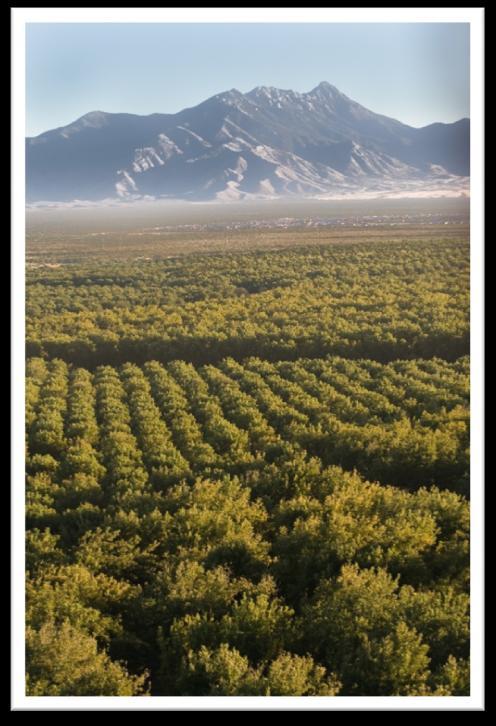
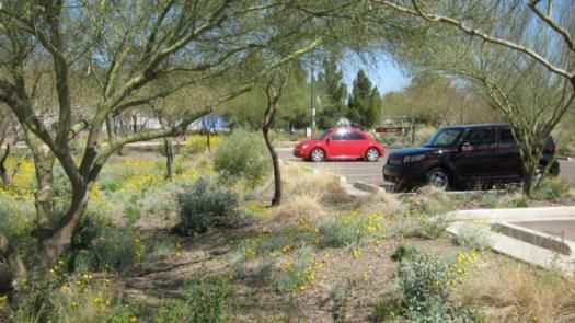
4 FICO s 6,000 Acres: Comprise One-Third of Sahuarita FICO Lands Additional 1,000 acres are in Pima County 4 4
5

6 What is a Specific Plan? Specific Plan is a document that regulates land use and development within a specified area of the town. Specific Plan Documents include: Site Analysis Existing Conditions Map and Text Elements Land Uses Open Space Streets/Circulation Drainage/Hydrology Water and Sewer Public Facilities & Services Development Standards Must satisfy technical requirements 6

7 Why Plan Now? Regional Growth Areas History has proven that if you do not plan for growth, growth will plan for you FICO experiencing growth pressures now infrastructure, ROW, utilities, community facilities 1990 s: Rancho Sahuarita Specific Plan Adopted : Town grew from 3,200 25,000 pop. What would area look like without Master Plan? Example: San Antonio River Santa Cruz River: 12 linear miles-single land owner Vision for river and blueprint for quality growth Proactive long-range planning allows for better decision-making for all Source: Pima Association of Governments 7


8 Community Land Use Plan 6,000 acres in Sahuarita and adjoining Green Valley: year plan River Park/Open Space Rural Neighborhoods Village Neighborhoods Urban Neighborhoods Employment Campus Campus Park Industrial Mixed Use Activity Centers River Center District 8

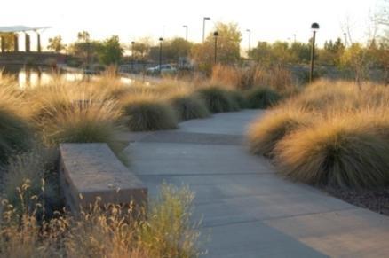
9 Open Space and Trails Approx. 2,100 acres of open space (over 1,000 in river corridor) 37% of total project area Consistent with O.S. Plans Linear Greenway Park Additional O.S. Corridors ~50 miles of trails 2 community / district parks Neighborhood parks ¼ mile walking distance 9

10 Community Villages 6,000 acres, year build-out Rancho Sahuarita The Groves: Employment focus Town/River Center: Urban core, primary activity centers River Park: Residential neighborhoods-district park Valle Vista: Rural character 10

11 Santa Cruz River.. The Common Thread - Linkage This makes property unique and special 12 linear miles single owner Over 1,000 acres of contiguous open space Regional recreational amenity for all Directly through center of town Ability and motivation to develop the plan now 11 Source: Town of Sahuarita
12 SANTA CRUZ RIVER MASTER PLAN Purpose Develop a conceptual river master plan for the Santa Cruz River through Sahuarita Farms
13 SANTA CRUZ RIVER MASTER PLAN Objectives Provide for safe development within the floodplain of the Santa Cruz River Provide for conveyance of the 100-year flood event
14 SANTA CRUZ RIVER MASTER PLAN Objectives Design of a sustainable river corridor that provides cost-effective multi-use opportunities for habitat enhancement, recharge, and flood control, while minimizing the costs for future public and private infrastructure located within the footprint of the river corridor.
15 SANTA CRUZ RIVER MASTER PLAN Objectives Enhance the river corridor as a benefit and amenity to the local community.

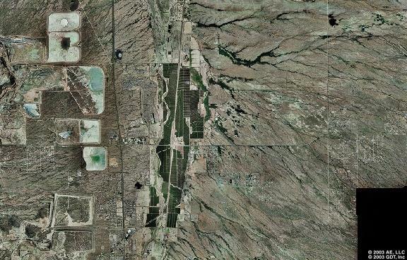
16 FICO SAHUARITA FARMS
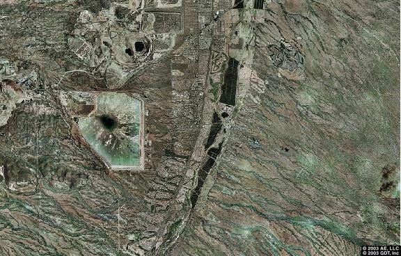
17 FICO CONTINENTAL FARMS
18 SANTA CRUZ RIVER MASTER PLAN Project Background Existing Conditions Previous Flooding (1977/1983/1993) Environmental/Biology Cultural Resources Offsite Tributaries Floodplain/Floodway
19 USGS Gage at Continental Road Peak Discharges from 1948 through 2006 Oct ,500 cfs Oct ,000 cfs Jan ,400 cfs
20 OCT 1977 FLOOD PHOTOS Discharge = 28,500 cfs


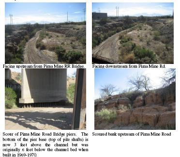
21 Continental Road Bridge West Abutment Failure
22 1983 AERIAL FLOOD PHOTOS Discharge = 45,000 cfs 100-year FEMA regulatory discharge

23 1983 Flood Continental Farms/Esperanza Wash

24 1983 Flood Continental Road

25 1983 Flood Continental Road

26 1983 Flood Confluence with Box Canyon Wash

27 1983 Flood Sahuarita Road

28 1983 Flood Sahuarita Road/Nogales Hwy

29 1983 Flood Pima Mine Road

30 1983 Flood Sahuarita Pima Mine Road
31 1993 FLOOD - AERIAL PHOTOS Discharge = 32,400 cfs

32 1993 Flood Continental Farms/Green Valley WWTP

33 1993 Flood UPRR Railroad Spur

34 1993 Flood Sahuarita Road Bridge

35 1993 Flood Pima Mine Road Railroad Bridge

36 1993 Flood Erosion at Fields

37 1993 Flood-Debris buildup on trees and sediment deposited in field

38 1993 Flood Sahuarita Road at Nogales Hwy
")
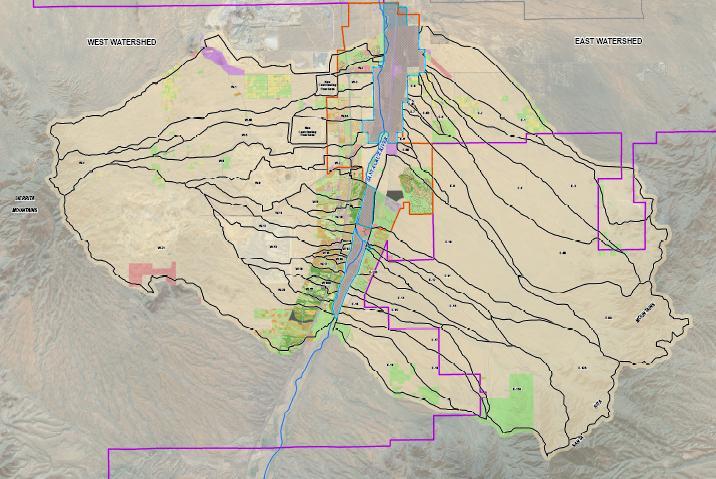
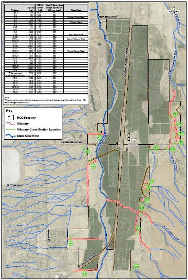
39 1993 Flood Pima Mine Road (looking south)

40 SANTA CRUZ RIVER


41 Environmental Purpose: 1. Identify potential environmental planning constraints, issues and sensitive areas 2. Address environmental surveying, permitting, and agency coordination

42 Environmental Topography/Physiography Biotic Communities and Vegetation Wildlife and Wildlife Movement Corridors Threatened, Endangered, and Sensitive Species/Habitat
43 Environmental Natural Resource Zone Map Potential Jurisdictional Waters of the US

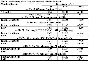
44 Environmental Recommendations: Conduct Native Plant Survey Enhance vegetation along drainages for habitat Species specific survey for Pima Pineapple cactus Potential Clean Water Act Section 404 permit for tributaries
 10,300")
45 Cultural Conducted a Class I Records Search 1 mile radius along river corridor Area of Potential Effect (APE) 10,300 acres
46 Cultural Recommendations: Full cultural survey any areas not field checked in last 10 years before necessary mitigation for river improvements Assess historical properties outside project area not directly impacted by development; effects for setting, feel, and association with surrounding landscape

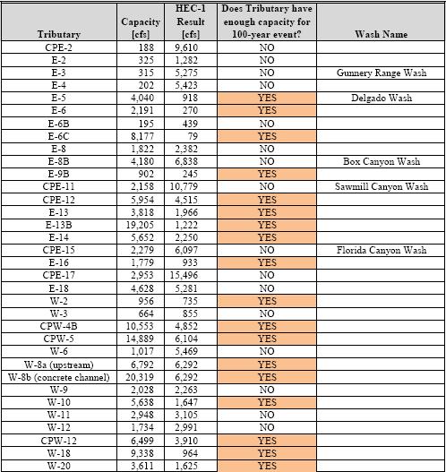
47 Offsite Tributaries Purpose: Conduct drainage study to determine the offsite 100-year flows at locations along the Santa Cruz River at the FICO property boundaries. Analyze the capacity of the tributaries vs. the 100-year flow.


48 Soils Mapping Drainage Area Map


49 Land Use Map Flowpath Map
50
51 Offsite Tributary Analysis Findings 3-hr 100-year storm 16 out of 34 tributaries do not have the capacity of the 100-year event
52 PLANNING CONSTRAINTS AND OPPORTUNITIES Q 100 = 45,000 cfs (regulatory) Q design = 55,000 cfs (Pima County Floodplain Ordinance) Existing Floodplain/Floodway Land Ownership/Town and County Jurisdictions Jurisdictional Waters of the US for river and Tributaries Tributaries
53 Terraced Channel Typical Section
54 Erosion Hazard Setback Typical Section

55 Terraced and Erosion Hazard Sections 55

56 River Master Plan Elements Erosion Hazard Section Elimination of West Overbank EHS overbank ft Lateral Weir to return flow to floodplain Structural Section Terraces on both banks ft wide Low flow channel: year flood Bank protected Levee to capture active east overbank flows Recover Lands from Floodplain 56
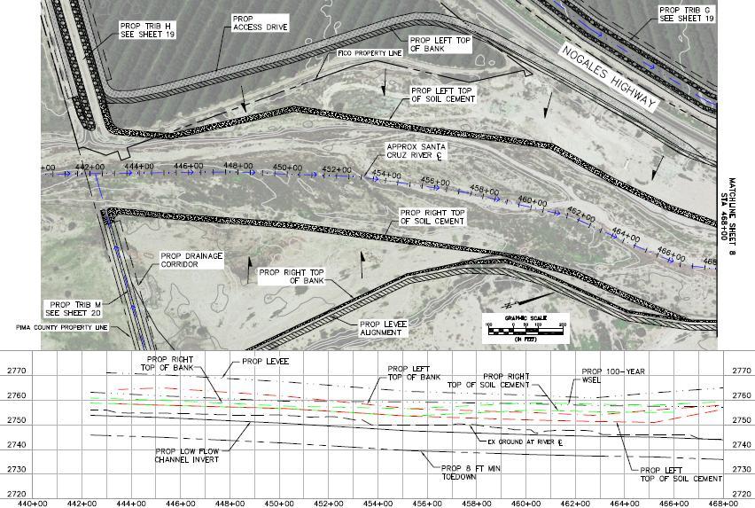
57 Santa Cruz River Sediment Transport Scour Evaluation Long Term Analysis
58
59 Current vs Historic Aerials

60 Current vs Historic Aerials
61
62 Santa Cruz River Hydrograph Attenuation Analysis
63
64
65 Proposed Conditions Hydraulics, Sediment, Scour

66 Proposed River Conditions Work Map

67 Proposed River Conditions Work Map

68 Proposed River Conditions Work Map
69
70 River Master Plan Typical Sections
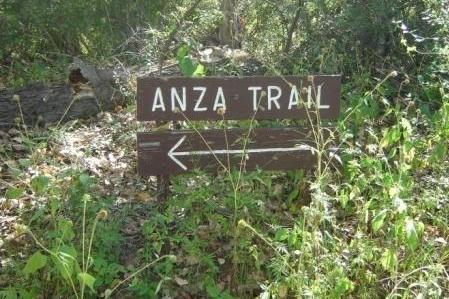
71
72
73
74
75


76 Santa Cruz River Enhancements Improvement Concepts (upper terrace) Wetland and natural water recharge Native vegetation and wildlife corridors Trails and tranquil open spaces Active recreation Gateway and trailheads 76

77 Santa Cruz River Enhancement Re-establish Habitat 77

78 Santa Cruz River Enhancement Passive Recreation 78


79 Santa Cruz River Enhancement Active Recreation 79

80 Santa Cruz River Enhancement Gateway/Trailhead Connection to trails 80


81 Early Phase: River Park Trailhead and Anza Trail 81
82 SANTA CRUZ RIVER MASTER PLAN Project Benefits Public Safety Regional Flood Control Recreation Habitat and Wildlife Regional Access and Connectivity Water Conservation and Recharge Opportunities

83 Questions??? Cruz the River
Farmers Investment Co. (FICO) Continental Farms
 Continental Farms") Farmers Investment Co. (FICO) Continental Farms Planning & Zoning Commission Study Session (River Master Plan) January 25, 2012 FICO Property 7,000 acres total area 6,000 acres in Town of Sahuarita 1,000
Farmers Investment Co. (FICO) Continental Farms Planning & Zoning Commission Study Session (River Master Plan) January 25, 2012 FICO Property 7,000 acres total area 6,000 acres in Town of Sahuarita 1,000
Farmers Investment Co. (FICO) Sahuarita Farms Specific Plan & Minor General Plan Amendment Community Meeting July 1, 2014
 Sahuarita Farms Specific Plan & Minor General Plan Amendment Community Meeting July 1, 2014") Farmers Investment Co. (FICO) Sahuarita Farms Specific Plan & Minor General Plan Amendment Community Meeting July 1, 2014 FICO / Property Overview FICO Properties 7,000 Acres Total 5,900 Acres in Town
Farmers Investment Co. (FICO) Sahuarita Farms Specific Plan & Minor General Plan Amendment Community Meeting July 1, 2014 FICO / Property Overview FICO Properties 7,000 Acres Total 5,900 Acres in Town
Town of Sahuarita Open Space Plan Element. University of Arizona Planning Program Projects Team
 Town of Sahuarita Open Space Plan Element University of Arizona Planning Program Projects Team Introduction Planning students in the Planning Program Project Class Overall Goal Potential uses of $1.5 Million
SECTION 5: REACH RECOMMENDATIONS/MAPS
 SECTION 5: REACH RECOMMENDATIONS/MAPS This section describes areas of concern and provides specific recommendations for each project reach. Locations of stormwater drains were from GIS coverage supplied
Stormwater Regulations & Considerations Morse Study Area. Pam Fortun, P.E. CFM Senior Stormwater Treatment Engineer Engineering Services Division
 Stormwater Regulations & Considerations Morse Study Area Pam Fortun, P.E. CFM Senior Stormwater Treatment Engineer Engineering Services Division Stormwater Regulations Development Considerations Floodplain
ROSEMONT 138kV TRANSMISSION LINE PROJECT. Public Open House Meeting #2 August 27, 2009
 ROSEMONT 138kV TRANSMISSION LINE PROJECT Public Open House Meeting #2 August 27, 2009 Project Overview Tucson Electric Power (TEP), as a part of its obligation to serve, is proposing to construct and operate
Chapter 5: Natural Resources and Environment
 NATURAL RESOURCES AND ENVIRONMENT 5-1 5 Chapter 5: Natural Resources and Environment BACKGROUND AND INTENT Urban expansion represents the greatest risk for the future degradation of existing natural areas,
APPENDIX A 6 CONCEPTUAL PRELIMINARY PLAN GUIDE AND CHECKLIST FOR MAJOR SUBDIVISIONS CARRBORO DEVELOPMENT GUIDE APPENDIX A
 6 CONCEPTUAL PRELIMINARY PLAN GUIDE AND CHECKLIST FOR MAJOR SUBDIVISIONS Conceptual Preliminary Guide/Checklist for Major Subdivisions Page 1 FORM: REVIEW DATE: CONCEPTUAL PLAN REVIEW 2000 REVIEWED BY:
Parks, Trails, and Open space Element
 Parks, Trails, and Open space Element Parks, Trails, and Open Space element Parks, Recreation, and Open Space are important components of the quality of life desired by the residents of Elk Grove. This
Draft Stillwater 2030 Comprehensive Plan- Goals and Policies
 Draft Stillwater 2030 Comprehensive Plan- Goals and Policies Instructions- Review each goal and policy and discuss with group any changes, deletions for additions to the list using your groups pen. Keep
National Association of Conservation Districts. Kris Hoellen Vice President, Sustainable Programs The Conservation Fund September 19, 2013
 National Association of Conservation Districts Kris Hoellen Vice President, Sustainable Programs The Conservation Fund September 19, 2013 Our Mission The Conservation Fund forges partnerships to conserve
Richton Park Western Development Corridor Green Infrastructure Development Plan August 18, 2017
 Richton Park Western Development Corridor Green Infrastructure Development Plan August 18, 2017 Conservation Design Forum Geosyntec Consultants 403 W. St. Charles Road 1420 Kensington Road, Suite 103 Lombard,
LAND USE ELEMENT. Purpose. General Goals & Policies
 LAND USE ELEMENT Purpose This Land Use Element contains the goals and policies necessary to support the City s responsibility for managing land resources and guiding development through implementing regulations,
City of Iowa City Department of Neighborhood and Development Services Department of Parks and Recreation Department of Public Works City Manager s
 RFP Pre-submittal meeting December 18, 2015 City of Iowa City Department of Neighborhood and Development Services Department of Parks and Recreation Department of Public Works City Manager s Office Background
Parks, Trails, and Open Space Element
 P arks, Recreation, and Open Space are important components of the quality of life desired by the residents of Elk Grove. This Element of the General Plan addresses the City s goals, policies, and actions
MEMORANDUM. September 10, 2018
 September 10, 2018 MEMORANDUM TO: Chad Bird, City of Decorah FROM: Larry Weber and Dan Gilles, Iowa Flood Center, IIHR Hydroscience & Engineering COPY TO: Dana Werner, St. Paul District Corps of Engineers,
AMENDMENT NO. 30 TO THE OFFICIAL PLAN OF THE TOWN OF MILTON
 AMENDMENT NO. 30 TO THE OFFICIAL PLAN OF THE TOWN OF MILTON Subject: Boyne Survey Secondary Plan and Related Official Plan Amendments The following text and schedules constitute Amendment No. 30 to the
TABLE OF CONTENTS LIST OF FIGURES
 TABLE OF CONTENTS INTRODUCTION... 1 HYDRAULIC EVALUATION... 7 TRAFFIC EVALUATION & RECOMMENDATION... 8 UTILITIES... 13 GEOTECHNICAL EVALUATION... 14 ENVIRONMENTAL OVERVIEW... 15 AESTHETICS, WILDLIFE, AND
When planning stormwater management facilities, the following principles shall be applied where possible.
 2.0 Principles When planning stormwater management facilities, the following principles shall be applied where possible. 2.0.1 Drainage is a regional phenomenon that does not respect the boundaries between
Improving Communities Through the Arroyo Seco Sustainability Campaign and Watershed Assessment
 Improving Communities Through the Arroyo Seco Sustainability Campaign and Watershed Assessment Arroyo Seco Headwaters in the San Gabriel Mountains Major tributary to the Los Angeles River 44 square mile
Floodplain Technical Memorandum
 Southeast Extension Project Lincoln Station to RidgeGate Parkway Prepared for: Federal Transit Administration Prepared by: Denver Regional Transportation District May 2014 Table of Contents Page No. Chapter
APPENDIX K WINDSOR OFFICIAL PLAN
 CEAA ENVIRONMENTAL ENVIRONMENTAL IMPACT ASSESSMENT AMBASSADOR BRIDGE ENHANCEMENT PROJECT Replacement Span and Plaza Expansion APPENDIX K WINDSOR OFFICIAL PLAN Avalon Consulting Professionals of Ontario,
INTRODUCTION PLANNING HISTORY
 INTRODUCTION The Upper Rock Creek Master Plan Area lies in the east central part of Montgomery County. The Master Plan Area is adjacent to the City of Rockville to the south, the Olney Planning Area to
RECOMMENDATIONS. Design Recommendations
 RECOMMENDATIONS While the San Diego River Park will serve to unify the river as a whole, each reach of the river park maintains distinct resources and character. Recommendations for each reach have been
SOUTHWEST CORRIDOR EXTENSION. Environmental Evaluation and Basic Engineering Results PUBLIC MEETING/OPEN HOUSE November 18, 2009
 SOUTHWEST CORRIDOR EXTENSION Environmental Evaluation and Basic Engineering Results PUBLIC MEETING/OPEN HOUSE November 18, 2009 AGENDA I. Welcome/Introductions II. Project Review and Status III. Environmental
APWA Expo August 27, Ground Water Recharge With Storm Management: A Sustainable Development
 APWA Expo August 27, 2013 Ground Water Recharge With Storm Management: A Sustainable Development Presented by: Joel S. Koenig, P.E. Andrew J. Hawkins Chris P. Dagiantis, P.E., CFM Bios Joel S. Koenig,
TREASURE COAST REGIONAL PLANNING COUNCIL M E M O R A N D U M. To: Council Members AGENDA ITEM 5I
 TREASURE COAST REGIONAL PLANNING COUNCIL M E M O R A N D U M To: Council Members AGENDA ITEM 5I From: Date: Subject: Staff December 12, 2008 Council Meeting Local Government Comprehensive Plan Review Town
Definitions. Average Daily Traffic Demand (ADT): The actual number or projected number of cars that pass a point in a 24-hour period.
: The actual number or projected number of cars that pass a point in a 24-hour period.") Definitions Access Management: A combination of physical techniques and transportation policies used to control the flow of traffic between roads and the surrounding lands. Alternative City Form Scenarios:
Definitions Access Management: A combination of physical techniques and transportation policies used to control the flow of traffic between roads and the surrounding lands. Alternative City Form Scenarios:
San Diego River Coalition 2012 Work Plan
 San Diego River Coalition 2012 Work Plan Adopted November 18, 2011 The mission of the San Diego River Coalition is preserve and enhance the San Diego River, its watershed, and its natural, cultural and
IV. Development in the Rural Overlay District
 Intracoastal Waterway Route 17 Route 168 Great Dismal Swamp VIRGINIA NORTH CAROLINA IV. Development in the Rural Overlay District IV-1 Route 17 in Chesapeake s Rural Overlay District affords distant views
Green Gables. April 24, 2013
 Green Gables Preliminary and Final Plat April 24, 2013 Development Team Green Gables Development Corporation (Owner/Developer) DTJ Design (Planner/Landscape Architect) Enertia Consulting Group (Civil Engineer)
City of Nogales General Plan
 Open Space, Parks, Recreation and Trails City of Nogales General Plan Residents of Nogales place a high priority in the development of a comprehensive system of open space, parks, recreation and trails
Checklists. Project Name: Location: File Number: Date of Submittal: Reviewer: Date: Applicant: Contact Name: Phone Number:
 Applicant: Contact Name: Phone Number: Email: Project Name: Location: File Number: Date of Submittal: Reviewer: Date: Concept Plan Requirements: I. General Project Information 1. Address or parcel number
Northwest Rail Corridor and US 36 BRT Development Oriented Transit Analysis 4.4 STATION AREA FINDINGS
 4.4 STATION AREA FINDINGS Each station is different, and each one requires a separate set of recommendations based on the vision for the site. This section outlines an initial TOD strategy and recommendations
Urban runoff in my neighborhood (Capitol Hill) is heavy with trash and other debris.
 is heavy with trash and other debris.") South Platte River Meeting Comments & s #1 I am a huge fan of river areas and would love the Platte and surrounding waterways to improve to allow habitat for wildlife and recreation opportunities for citizens.
South Platte River Meeting Comments & s #1 I am a huge fan of river areas and would love the Platte and surrounding waterways to improve to allow habitat for wildlife and recreation opportunities for citizens.
Secrest Short Cut and Monroe Expressway Small Area Plan AUGUST 29, 2018
 Secrest Short Cut and Monroe Expressway Small Area Plan AUGUST 29, 2018 Background and Process Monroe Expressway will be open by the end of 2018 Union County and Indian Trail identified a need to revisit
RECREATION AND OPEN SPACE ELEMENT GOALS, OBJECTIVES, AND POLICIES
 RECREATION AND OPEN SPACE ELEMENT GOALS, OBJECTIVES, AND POLICIES Goal 7 To provide park facilities, recreation programs, and open space resources that are safe, adequate, and accessible to all City residents,
Mitchell Ranch South MPUD Application for Master Planned Unit Development Approval Project Narrative. Introduction
 Mitchell Ranch South MPUD Application for Master Planned Unit Development Approval Project Narrative Introduction Mitchell Ranch South is a proposed single family (detached) residential development on
Natural Resource Protection
 VISION Our Parker community will enhance the quality of life by avoiding development in environmentally hazardous areas and by safeguarding the natural environment. Natural Resource Protection Introduction
SHEFFIELD PARK Paulding County, GA DRI #588
 SHEFFIELD PARK Paulding County, GA DRI #588 Supplemental Information for RDC s DRI (Form 2) Review August 16, 2004 Prepared for: Mr. David Howerin Coosa Valley RDC 1 Jackson Hill Drive Rome, GA 30161 P.O.
WILLAMETTE FALLS LEGACY PROJECT
 OPPORTUNITIES & CONSTRAINTS There are here three falls on a line of rocks extending across the river, which forms the bed of the upper channel. The water is precipitated through deep abrazed gorges, and
A Joined-up Regional Landscape: A Roadmap to connect the parts
 Breaking the Barriers: Engineering Solutions to Ecological Problems A Joined-up Regional Landscape: A Roadmap to connect the parts Associate Professor Darryl Low Choy Urban Research Program Outline Nature
Improve Neighborhood Design and Reduce Non Point Source Water Pollution
 HOW TO Planning Guide Improve Neighborhood Design and Reduce Non Point Source Water Pollution This document was funded by a grant from the New Hampshire Coastal Program with funding from the National Oceanic
7Page 1 CLEMMONS COMMUNITY COMPASS 1 PLAN OVERVIEW
 1 Plan Overview WHAT IS I THE CLEMMONS COMMUNITY COMPASS? The Clemmons Community Compass is our community s comprehensive plan. It serves as our blueprint and provides direction for the future of the Village
THREE-STEP DESIGN PROCESS FOR OPEN SPACE SUBDIVISIONS
 00216106.DOC NMA/RRK 1/30/14 THREE-STEP DESIGN PROCESS FOR OPEN SPACE SUBDIVISIONS Open space subdivisions, sometimes called cluster developments, maintain a significant portion of a development site in
IMPLEMENTING SOMERSET COUNTY S INVESTMENT FRAMEWORK
 IMPLEMENTING SOMERSET COUNTY S INVESTMENT FRAMEWORK SMART CONSERVATION THROUGH SMART GROWTH NJ LAND CONSERVATION RALLY March 22, 2014 Laurette Kratina, PP, AICP, Supervising Planner Somerset County Planning
Weston Conservation Commission
 Weston Conservation Commission Commission Roles and Responsibilities Laws that protect Wetlands What residents can do to protect wetlands and open space 1 Conservation Commission Made up of 7 volunteer
Zoning Ordinance Chapter 10
 CHAPTER 10 - WASHES SECTION 10.0 GENERAL: A. The purpose of this Ordinance is to establish standards for development in or near Major and Minor Washes as defined in Appendix A Glossary of Terms and Definitions
4. ENVIRONMENTAL IMPACT ANALYSIS 7. LAND USE AND PLANNING
 4. ENVIRONMENTAL IMPACT ANALYSIS 7. LAND USE AND PLANNING 4.7.1 INTRODUCTION The following analysis discusses the consistency of the Proposed Project with the corresponding land use and zoning designations
Ten Mile Creek Planning Area
 PLANNING AREA POLICIES TEN MILE CREEK Ten Mile Creek Planning Area Location and Context The Ten Mile Creek Planning Area ( Ten Mile Creek area ) is located south of the current Boise AOCI, generally south
INTEGRATING NATURAL RESOURCES INTO A DEVELOPMENT, PUBLIC AND PRIVATE ROLES
 INTEGRATING NATURAL RESOURCES INTO A DEVELOPMENT, PUBLIC AND PRIVATE ROLES Why? Integrating natural resources into a development can increase its market value, enhance the quality of life for those who
Exhibit A Comprehensive Plan Amendments
 Exhibit A Comprehensive Plan Amendments May 2010 Draft Chapter One - Introduction Chapter One INTRODUCTION NOTE: For brevity and ease in viewing the proposed changes, portions of chapter one that are not
RECREATION, OPEN SPACE AND GREENWAYS ELEMENT GOALS, OBJECTIVES, AND POLICIES
 RECREATION, OPEN SPACE AND GREENWAYS ELEMENT GOALS, OBJECTIVES, AND POLICIES GOAL R-1: DEVELOP A RECREATION, OPEN SPACE AND GREENWAYS SYSTEM AS AN INTEGRAL COMPONENT OF AN OVERALL, COUNTY-WIDE ECONOMIC
Design Specifications & Requirements Manual
 11 PARKS & OPEN SPACES 11.1 DEFINITIONS... 1 11.1.1 Neighbourhood Parks... 1 11.1.2 District Parks... 1 11.1.3. Sport Parks... 1 11.1.4 Urban Parks... 1 11.1.5 Civic Spaces... 1 11.1.6 Open Space System...
APPENDIX C SPECIAL PLANNING AREAS
 SPECIAL PLANNING AREAS There are five Special Planning Areas (SPAs) on the Land Use Diagram (Figure LU-2). The SPAs are areas with significant new growth potential that require more detailed subsequent
The Napa River Flood Protection Project
 The Napa River Flood Protection Project Creating Flood Protection and Restoring Geomorphic and Biological Processes Jeremy Sarrow, Napa County Flood Control & Water Conservation District June 2, 2014.
Public Review Draft Oceanside Subarea Habitat Conservation Plan/ Natural Communities Conservation Plan
 Oceanside Subarea Habitat Conservation Plan/ Natural Communities Conservation Plan Prepared for City of Oceanside Planning Department 300 N. Coast Highway Oceanside, CA 92054 Prepared by Ogden Environmental
Municipal Plan*Assessment
 Municipal Plan*Assessment This tool was developed to assist in reviewing municipal master plans and in determining if these plans are consistent with smart growth principles, neighboring municipal plans,
Working together to leverage limited Funds
 Working together to leverage limited Funds ARAPAHOE COUNTY OPEN SPACES 10 County Budget Conference September 20, 2013 The Power of Partnerships 2013 SORP Conference 5/23/2014 Why Talk About Open Space?
FY Capital Improvement Program Arroyo Projects - Lower Arroyo Summary
 LOWER ARROYO FY 214-218 Capital Improvement Program Description FY 213 FY 214 FY 215 FY 216 FY 217 FY 218 1 Bird Sanctuary Improvements (7749) 35, 225, 125, 2 Lower Arroyo - Implement Master Plan - Signage
MAYFIELD WEST SECONDARY PLAN PHASE 2
 MAYFIELD WEST SECONDARY PLAN PHASE 2 Public Open House #3 February 25, 2010 Draft Preferred Land Use Scenario TOWN OF CALEDON PLANNING & DEVELOPMENT DEPARTMENT Open House Agenda TOWN OF CALEDON 1. Welcome
Appendix E Preliminary Location Hydraulic Study
 Appendix E Prepared for: State of Alaska Department of Transportation and Public Facilities Prepared by: HDR Alaska, Inc. 2525 C Street, Suite 305 Anchorage, Alaska 99503 February 2014 This page intentionally
Technical Memorandum 5
 Technical Memorandum 5 Environmental Resources August 2015 PREPARED BY AECOM Table of Contents Introduction... 3 Natural Features... 6 Watersheds... 6 Rivers, Lakes, Creeks... 6 Wetlands... 8 Floodplains...
7.0 SOCIAL, ECONOMIC, AND ENVIRONMENTAL ISSUES
 7.0 SOCIAL, ECONOMIC, AND ENVIRONMENTAL ISSUES The following list of social, economic, and environmental issues have been identified based on a preliminary inventory of resources in the project area, an
Woodland Conservation and the Master Plan
 1 WHAT IS A MASTER PLAN? A Vision for the Future of Your Community Woodland Conservation and the Master Plan Goals Objectives Strategies 2 How Will Your Community Look? TREE PRESERVATION AND THE MASTER
FLOOD ISSUE 62 INTRODUCTION
 V I S I O N 2 0 3 0 Southwest Missouri is known for its extreme range in weather that can cause flash flooding in a moment s notice. This flooding can unfortunately lead to extreme damage and serious injury,
Washington County, Maryland Division of Public Works Policy Manual
 Washington County, Maryland Division of Public Works Policy Manual Subject: Downstream Drainage Easement Category: Land Development Engineering Number: 7-4.1 Date: June 1, 2009 (effective) PURPOSE: The
Mariposa Lakes. Planned Community. Project Overview. Stockton, CA
 Planned Community Stockton, CA Project Overview March 2007 Summary of Proposed Community is a master-planned community proposed for development on approximately 3,810 acres in southeast Stockton. In 2004,
March 14, Will Allen Director of Strategic Conservation Planning
 New Frontiers in Land Conservation: Green Infrastructure for Urban Vacant and Underutilized Lands 23 rd Annual RMLUI Conference March 14, 2014 Will Allen Director of Strategic Conservation Planning Special
Regional Open Space Conservation Plan. Regional Staff Committee January 18, 2018
 Regional Open Space Conservation Plan Regional Staff Committee January 18, 2018 Schedule We are here Task 1 - Stakeholder Input & Work Plan Dev. v z 2016 2017 2018 Oct Nov Dec Jan Feb Mar Apr May Jun Jul
5. LOW IMPACT DEVELOPMENT DESIGN STANDARDS
 5. LOW IMPACT DEVELOPMENT DESIGN STANDARDS Low Impact Development (LID) requires a shift in stormwater management away from conveying runoff to a small number of downstream points through hydraulically
Design Specifications & Requirements Manual
 11 PARKS & OPEN SPACES 11.1 DEFINITIONS... 1 11.1.1 Neighbourhood Parks... 1 11.1.2 District Parks... 1 11.1.3. Sport Parks... 1 11.1.4 Urban Parks... 1 11.1.5 Civic Spaces... 1 11.1.6 Open Space System...
APPENDIX C. Architectural and Environmental Design Standards. Environmentally sensitive areas should be protected.
 APPENDIX C Architectural and Environmental Design Standards Environmentally Sensitive Areas Goal A. Environmentally sensitive areas should be protected. Development, such as roads, houses, and other structures,
Greenways as an alternative to traditional infrastructure. Green Infrastructure
 Greenways as an alternative to traditional infrastructure Green Infrastructure What is a Greenway? Little (1990) - A linear open space along a natural or human made corridor. Fabos - linked corridors nature
Potential Green Infrastructure Strategies May 6, 2015 Workshop
 Potential Green Infrastructure Strategies May 6, 2015 Workshop Background The City of Cortland is developing the Tioughnioga Urban Headwaters Green Infrastructure Action Plan with funding from the National
Authority of the General Plan
 Authority of the General Plan This La Habra Heights General Plan will serve as the blueprint for future planning and development in the City. This General Plan describes the City s vision for the future
Natomas Joint Vision Open Space Plan
 Natomas Joint Vision Open Space Plan First Workshop series The City of Sacramento The County of Sacramento LAFCo ERA Economic Research Associates EIP Associates a Division of PBS & J Natomas Joint Vision
Working Group Meeting
 April 4,, 2017 Parks Operations Bldg Working Group Meeting Arts Districts Overview Stormwater/RPA/Stream Considerations First Principles Agenda 7:00pm 7:05pm 7:10pm 7:40pm 8:30pm 9:40pm 9:45pm Welcome
DISCUSSION TOPIC: ST JOHNS RIVER & ITS TRIBUTARIES (BPII) 2030 COMPREHENSIVE PLAN POLICES AND REGULATORY FRAMEWORK
 2030 COMPREHENSIVE PLAN POLICES AND REGULATORY FRAMEWORK") DISCUSSION TOPIC: ST JOHNS RIVER & ITS TRIBUTARIES (BPII) 2030 COMPREHENSIVE PLAN POLICES AND REGULATORY FRAMEWORK St. John s River & Its Tributaries Issue Summary: The St. Johns River is an important
DISCUSSION TOPIC: ST JOHNS RIVER & ITS TRIBUTARIES (BPII) 2030 COMPREHENSIVE PLAN POLICES AND REGULATORY FRAMEWORK St. John s River & Its Tributaries Issue Summary: The St. Johns River is an important
LOUISIANA STATE UNIVERSITY COMPREHENSIVE & STRATEGIC CAMPUS MASTER PLAN. APPENDIX G - Stormwater Study Findings & Stormwater Solutions
 LOUISIANA STATE UNIVERSITY COMPREHENSIVE & STRATEGIC CAMPUS MASTER PLAN APPENDIX G - Stormwater Study Findings & Stormwater Solutions LSU: MP Narrative July 2017 3.5 Open Space Existing Conditions The
Climate Smart Communities Green Infrastructure Case Studies
 New York State Water Resources Institute Climate Smart Communities Green Infrastructure Case Studies Emily Vail Hudson River Estuary Program NYS Department of Environmental Conservation Cornell University
Once Upon a Gravel Pit: Reconnecting Floodplain through Aggregate Extraction
 Once Upon a Gravel Pit: Reconnecting Floodplain through Aggregate Extraction 5 th International Conference on Natural Channel Systems September 26, 2016 1 The Story of Snyder s Flats Historical influences
Los Angeles River-Arroyo Seco Confluence Restoration Vision Plan. Professor Meredith McKenzie, JD Urban & Regional Planning Dept Cal Poly Pomona
 Los Angeles River-Arroyo Seco Confluence Restoration Vision Plan Professor Meredith McKenzie, JD Urban & Regional Planning Dept Cal Poly Pomona The Los Angeles River Watershed Arroyo Seco Watershed Map
The following principles guide the development of goals and strategies to protect and promote these amenities:
 OPEN SPACE/PARKS/TRAILS/RECREATION GOALS/STRATEGIES Cherry Hills Village is a living environment that offers low density development, open areas, public scenic vistas, public trails and public parks. This
Jackson Highway Master Plans
 Jackson Highway Master Plans West Jackson Highway Master Plan (PLNP2008-00240) Jackson Township Specific Plan (PLNP2011-00095) NewBridge Specific Plan (PLNP2010-00081) Mather South Community Master Plan
STREAM BUFFERS
 88-415 STREAM BUFFERS 88-415-01 PURPOSE In the Kansas City region and throughout the nation, vegetated stream buffers have been clearly shown to protect stream stability and related infrastructure, improve
Public Consultation. Land at Monks Farm, North Grove. Welcome
 Welcome Welcome to our public exhibition for development on Land at Monks Farm, orth Grove. Gallagher Estates and Gleeson Strategic Land are preparing an outline planning application for new homes, open
edmonton.ca/ribbonofgreen #ribbonofgreen
 WHAT IS THE RIBBON OF GREEN? The Ribbon of Green is Edmonton s entire river valley and ravine system. The Ribbon of Green (2018) Project will provide strategic guidance for the southwest and northeast
Prado Ranch North Common Open Space Tentative Map. Washoe County Planning Commission July 3, 2018
 Prado Ranch North Common Open Space Tentative Map Washoe County Planning Commission July 3, 2018 Site Characteristics Intersection of Chickadee and Lemmon Drive ~1 mile north of Deodar/Lemmon Drive intersection
Draft Rhode Island Stormwater Design and Installation Standards Manual
 Draft Rhode Island Stormwater Design and Installation Standards Manual Summary The May 2009 Public Review Draft version of the RI Stormwater Design and Installation Standards Manual consists of approximately
Stormwater Management at The University of New Orleans
 University of New Orleans ScholarWorks@UNO DRU Workshop 2013 Presentations Disaster Resistant University Workshop: Linking Mitigation and Resilience Conferences and Workshops 3-1-2013 Stormwater Management
VALLEY VIEW POND Q&A. This item will be discussed under the First Reading portion of the agenda at the July 17, 2012 Village Council meeting.
 VALLEY VIEW POND Q&A This item will be discussed under the First Reading portion of the agenda at the July 17, 2012 Village Council meeting. 1. Please provide a history of the pond including Village maintenance
Glenborough at Easton Land Use Master Plan
 Land Use Framework November 30, 2007 2.0 LAND USE FRAME- WORK 2.1 LAND USE HISTORY and Setting Glenborough at Easton is located on property that was used for mining in the 19th and 20th centuries and rocket
G A R Y G R E E N L I N K APPENDIX A
 G A R Y G R E E N L I N K M A S T E R P L A N 1 American Bridge Property data American Bridge Property Manager 2 Little Calumet-Galien River Watershed Study Applied Ecological Services, Inc. 3 Final Assessment
Weston s Wetlands, Stormwater, & Open Space
 Weston s Wetlands, Stormwater, & Open Space Weston s Wetlands, Stormwater, & Open Space Conservation Commission Role and Responsibilities Laws that protect wetlands What residents can do to protect wetlands
Master Plan Objectives and Policies
 Master Plan Objectives and Policies Introduction This chapter identifies the Park issues and recommended policies established by this Master Plan. The issues were identified through meetings with staff,
Wallkill River. Floodplain Bench Project Phase 1. OCSWCD Kevin Sumner. October 2016 Orange County. Wendell Buckman
 Wallkill River Floodplain Bench Project Phase 1 October 2016 Orange County OCSWCD Kevin Sumner Wendell Buckman Introduction Location Define the Problem History Location MIDDLETOWN NEWBURGH PROJECT Location
NAI Principles In Gwinnett County
 NAI Principles In Gwinnett County By Cornelius Ani, LSIT, CFM Contributors: Adena Fullard, P.E., CPSWQ Rudresh Bihalli, P.E., CFM Ken Kagy, P.E., CPESC, CPSWQ Ligia Negru, M. Sc., CFM Maja Radovic, CPESC,
STORMWATER GREEN INFRASTRUCTURE AND PLANNING/ZONING BOARDS
 STORMWATER GREEN INFRASTRUCTURE AND PLANNING/ZONING BOARDS Source: Center for Watershed Protection, 2007 Southern Tier Central Regional Planning & Development Board Chemung County Stormwater Team OUTLINE
Keyport. Vision for Keyport
 Keyport Vision for Keyport Keyport is a rural, historic waterfront village bounded and limited in size by its natural borders of water and the Naval Undersea Warfare Center. The community consists primarily