March 14, Will Allen Director of Strategic Conservation Planning
|
|
|
- Audrey Lloyd
- 5 years ago
- Views:
Transcription
1 New Frontiers in Land Conservation: Green Infrastructure for Urban Vacant and Underutilized Lands 23 rd Annual RMLUI Conference March 14, 2014 Will Allen Director of Strategic Conservation Planning Special thanks to Claire Robinson & Loretta Quach at Amigos de los Rios Mark Eischeid, Edinburgh School of Architecture & Landscape Architecture Shrinking Cities Expanding Landscapes Conference November 2013


2 Talk Agenda 1. Define/discuss vacant and underutilized lands 2. Green infrastructure framework for urban lands 3. Revitalization case study: Amigos de los Rios Emerald Necklace in East Los Angeles County 4. Regional planning case study: Forest to Ocean Expanded Vision Plan for Los Angeles County 2
3 Vacant and Underutilized Urban Lands SHRINKING CITIES - According to the 2010 Census, almost 3 dozen U.S. cities that had populations over 100,000 in 1950 have lost at least 20% of their residents (Krohe, 2011) GROWING CITIES - Expanding cities [accumulate] non-productive space more rapidly than fixed cities This [results in a] fragmented urban core dotted with disconnected, small, irregularly spaced parcels of nonproductive space, or Urban Shrapnel (Newman, 2013) PLANNING FOR VACANT/UNDERUTILIZED URBAN LANDS Youngstown, Ohio (2005), Cleveland (2008), Detroit (2012) Conceptual strategy for right sizing with green infrastructure (Schilling and Logan, 2008) Green uses for surplus land, including urban agriculture, community green spaces, and alternative energy (LaCroix (2011); Krohe (2011); Morley (2010); Bonfiglio (2009) 3
 4.")
4 Expanding Green Infrastructure in Cities 1. Use suitability analysis to right-size Re-adjust built environment to match current and projected population and development trends 2. Identify opportunities for income generating uses Agriculture Aquaponics / Greenhouse Carbon Bank 3. Fulfill regulatory requirements Stormwater (US EPA MS-4/CSO) 4. Reduce gray infrastructure costs Water treatment 4


5 Green Infrastructure Framework for Vacant and Underutilized Urban Lands 1. Landscape/regional context 2. Community engagement 3. Green infrastructure typology 4. Project selection criteria 5. Optimize project investment portfolio Detroit Future City Land Use Framework: A Green City where landscapes contribute to health 5

6 1. Analyze landscape and regional context 6


7 2. Engage the community New York City 596 Acres Philadelphia Possible City Grounded in Philly New Orleans Living Lots 7


8 3. Define green infrastructure typologies Income Generating Urban Forest / Carbon Bank Native Tree/Plant Nursery Urban Agriculture Greenhouse / Aquaponics Alternative Energy Compliance/Regulatory Stream/Riparian Restoration Constructed Wetland / Stormwater Park / Rain Garden Phytoremediation Impervious Surface Removal Community Benefit Pocket Park/Playground/Ball Courts Recreational Trail Linkage Native Plant / Habitat Garden Community Garden 8

 Parcel Selected K 150 150 300 $12.")
9 4. Project Selection Criteria 1 Green Infrastructure for Vacant and Underutilized Urban Lands 11 Community Support 12 Feasibility Redevelopment Suitability Neighborhood Stabilization Ownership Status Demolition/Remediation 13 Opportunity Property Size/Configuration Strategic Location 14 Resource Value Site Characteristics Functional Connectivity G B L Parcel ID Answer 6 - Binary Linear Programming K Ecological Score H I Scenic Value A $4.5 B $5.0 C $6.0 D $5.0 E $6.5 F $7.0 G $7.0 H $6.5 I $9.0 J $4.5 L $ $24.5 C F E Total Benefits Cost ($m) Parcel Selected K $12.0 D A Yes Yes Yes Yes J 9
10 5. Optimize Conservation Portfolio -> ODST LSP scores generated for potential projects Use optimization tools to select best portfolio of projects based on budget C D B 100% OM 90% Rank Based 80% 45 degree line 70% A F E % Total Acres. 60% 50% 40% Parcel ID Ecological Score Cost A 2 $6 Parcel Selected 30% B 5 $3 20% C 4 $2 10% 0% 0% 10% 20% 30% 40% 50% 60% 70% 80% 90% 100% D 6 $6 E 2 $3 F 9 $4 % Total Costs Total:


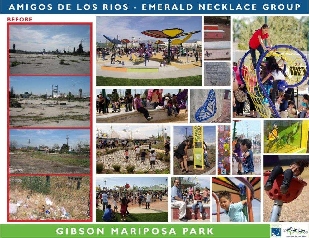
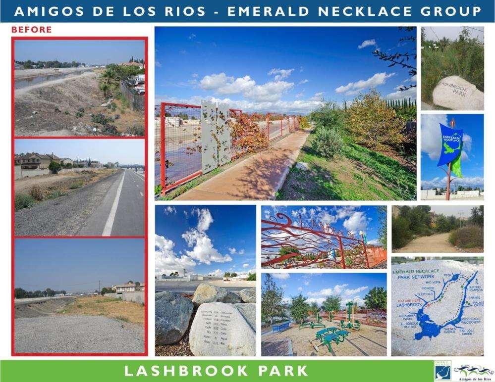
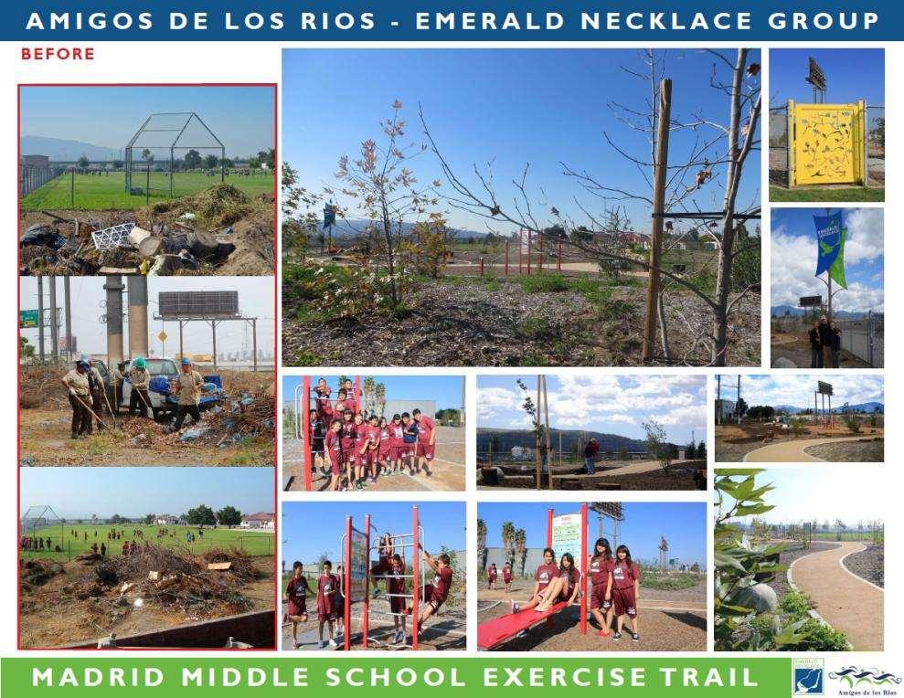
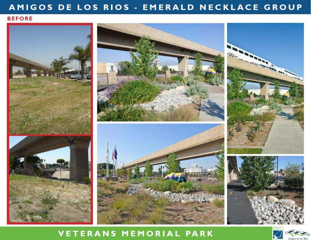
11 Amigos de los Rios Initial Case Study Area The Emerald Necklace is a vision for a 17-mile loop of parks and greenways connecting 16 cities and over 500,000 residents along the Río Hondo and San Gabriel Rivers and their tributaries. Temple City El Monte Baldwin Park Angeles National Forest Rosemead South El Monte Avocado Heights Catalina Island 11

12 Amigos de los Rios Initial Case Study Area 12
13 Amigos de los Rios Initial Case Study Area Green Infrastructure Public Health Urban biodiversity Native habitat restoration Groundwater infiltration Climate change / urban heat island mitigation Community forestry Active living / recreation Alternative transportation corridors Access to nature & outdoor classrooms Youth job training Natural & cultural heritage Way finding & interpretive signage 13

14 Amigos de los Rios Initial Case Study Area 14
15 15
16 16
17 17
18 18

19 Emerald Necklace Coalition / Accord Member Agencies Emerald Necklace Region Local Cities Coalition Member Cities City of Azusa City of Bell City of Downey City of Duarte City of Irwindale City of Baldwin Park City of El Monte City of South El Monte City of San Gabriel City of South Gate City of Whittier City of Monrovia City of Montebello City of La Puente Gateway Authority: 20 Cities Unincorporated Areas Hacienda Heights Homeowners Association Workman Mill Road Homeowners Association State & County Agencies Rivers & Mountains Conservancy Los Angeles County Board of Supervisors Community Based Organizations Charro Equestrian Joint Council Park El Monte Improvement Association School Districts El Rancho Unified - Pico Rivera El Monte Union El Monte City Rosemead Mountain View 19


20 Los Angeles County: From the Mountains to the Sea, Forest to Ocean San Gabriel Mountains Angeles National Forest Whittier Narrows Catalina Island 20

21 Los Angeles County: From the Mountains to the Sea, Forest to Ocean Throughout a century and a half of urban growth, LA and the surrounding region have exhibited a love-hate relationship with nature. Planning Los Angeles Commissioned by Citizens Committee on Parks, Playgrounds and Beaches 21

22 Expanded Vision Plan Area 22
23 Expanded Vision Plan Approach Define Regional Goals and Collaborative Priorities Convene Focus Group Meetings (8/2012, 2/2013) Synthesize Existing/Adopted Plans (60+) Identify Regional Scale Spatial Priorities in Vision Plan Analyze Priorities from Olmstead 1930 Plan Collect, Organize, and Assess Current GIS Mapping Layers and Supporting Resources (100+) Common Vision Plan Strategies Implement Existing Plan Recommendations Promote Best Practices in Design for All Link Across Boundaries and Scales Document Best Practice Case Studies 23
24 Expanded Vision Plan - Regional Goals 1. Promote Active Transportation Walking, Biking, and Alternative Commute Options 2. Create Functional and Multi-Purpose Natural (Green) and Built (Grey) Environment Networks 3. Improve Public Health by Expanding Access to Nature and Outdoor Recreation 4. Treat Water as a Multi-Benefit Amenity 5. Design and Build Communities Resilient to the Current and Projected Impacts of Climate Change 6. Enhance Regional Anchors for People and Wildlife 7. Support Environmental Awareness and Civic Engagement through Education, Outreach, and Cultural Heritage 8. Foster a Green Economy that Creates Jobs and Spurs Investment in Local Multi- Benefit Projects 24

25 New Frontiers in Land Conservation: Green Infrastructure for Urban Vacant and Underutilized Lands Will Allen Director of Strategic Conservation Planning Wordle
Green Infrastructure for Resiliency
 Green Infrastructure for Resiliency Climate Resilience Webinar Series Kendra J. Briechle U.S. Department of Housing and Urban Development Disclaimer This presentation is intended to provide communities
National Association of Conservation Districts. Kris Hoellen Vice President, Sustainable Programs The Conservation Fund September 19, 2013
 National Association of Conservation Districts Kris Hoellen Vice President, Sustainable Programs The Conservation Fund September 19, 2013 Our Mission The Conservation Fund forges partnerships to conserve
VACANT TO VIBRANT : GREEN INFRASTRUCTURE & URBAN REVITALIZATION
 VACANT TO VIBRANT : GREEN INFRASTRUCTURE & URBAN REVITALIZATION Calumet Summit 2013: Connecting for Action Lauren Riga, Director City of Gary Department of Green Urbanism Gary Storm Water Management District
A BLUEPRINT FOR BROCKTON A CITY-WIDE COMPREHENSIVE PLAN
 A BLUEPRINT FOR BROCKTON A CITY-WIDE COMPREHENSIVE PLAN Public Meeting October 2016 1 Plan Summary and Discussion Public Meeting May 4 2017 City of Brockton Bill Carpenter, Mayor Department of Planning
Smart Growth for Dallas
 Smart Growth for Dallas Data-driven decisions for the future of Dallas parks, open spaces, and green infrastructure Dallas Park and Recreation Board March 10, 2016 Agenda I. Welcome and Introductions II.
ICLEI Webinar Sustainability in the Master Plan and Zoning Code
 ICLEI Webinar Sustainability in the Master Plan and Zoning Code Sustainability in Grand Rapids 2000 2002 New Master Plan 2004 2005 Neighborhood Pattern Workbook 2006 2007 Form-Based Zoning Ordinance 2007
Parks, Open Space and Trails
 Introduction Parks have often been referred as the lungs of our cities, cleansing the air of pollutants and particulate matter. Parks are also gathering places for families and community. They offer spaces
RECOMMENDATIONS. Design Recommendations
 RECOMMENDATIONS While the San Diego River Park will serve to unify the river as a whole, each reach of the river park maintains distinct resources and character. Recommendations for each reach have been
The Benefits and Challenges Associated with Green Infrastructure Practices
 The Benefits and Challenges Associated with Green Infrastructure Practices Thomas M. Evans ASLA, LEED AP Regional Green Infrastructure Design Services Director OWEA Technical Conference, June 20, 2013
10.0 Open Space and Public Realm
 10.0 Open Space and Public Realm 10.0 Open Space and Public Realm The Public Open Space System is comprised of: outdoor spaces available for public use that are either publicly owned (e.g., parks and
Authority of the General Plan
 Authority of the General Plan This La Habra Heights General Plan will serve as the blueprint for future planning and development in the City. This General Plan describes the City s vision for the future
Green Infrastructure. by Karen Engel, NYS DEC. NYS Department of Environmental Conservation
 Green Infrastructure by Karen Engel, NYS DEC What is Green Infrastructure? For some it s all about water Green Infrastructure techniques use soils and vegetation to infiltrate, evapotranspirate, and/or
This page intentionally blank.
 This page intentionally blank. Parks, Recreation, and Open Space Chapter Relationship to Vision Vision Parks, Recreation and Open Space Chapter Concepts County Government. County government that is accountable
Portage County Parks, Trails and Greenways Plan
 Portage County Parks, Trails and Greenways Plan Agenda for Local Planning Meeting Introductory Presentation Why we need a Plan Plan project goals and process Benefits Overview of local planning region
Sustainable Infrastructure and South Mountain Village: Land Use and Transit Oriented Development
 Sustainable Infrastructure and South Mountain Village: Land Use and Transit Oriented Development COURSE PROJECT PRESENTATION 23 April 2018 Tari Alford Hanan Alhashmi Aric Burks Matt Gomez Matthew Waldman
Western City District What we heard
 What we heard Vision to 2056 and Priorities Governance and implementation Infrastructure and funding The protection of the natural landscape including biodiversity and the Metropolitan Rural Area for food
Green Infrastructure Policies and Ordinances
 Green Infrastructure Policies and Ordinances October 23, 2013 By Karen Firehock, Green Infrastructure Center 2013 Georgia Urban Forest Council s 23 rd Annual Conference The mission of the nonprofit Green
SFE Policy Committee Presentation. Rachel Kraai
 SFE Policy Committee Presentation Rachel Kraai February 9, 2015 Today s Agenda Green Infrastructure Overview Biodiversity via SSIP Capital Projects Triple Bottom Line (TBL) Framework and Analysis TBL Criteria
SUSTAINABILITY PLAN OTTAWA COUNTY PARKS AND RECREATION COMMISSION FALL 2017
 SUSTAINABILITY PLAN OTTAWA COUNTY PARKS AND RECREATION COMMISSION FALL 2017 Table of Contents Introduction Natural Resources Quality of Life Community Continuing the Mission Sustainability Measuring Sustainability
CHAPTER 1 Introduction
 CHAPTER 1 Introduction From sea to summit, Lane County covers almost 4,800 square miles of diverse Oregon landscape. Stretching from the Pacific Ocean through the Coastal Range, the Willamette Valley to
Objectives and Strategies for the Integration of Recreation, Parks and Open Space in Regional Plans
 BULLETIN 2 Objectives and Strategies for the Integration of Recreation, Parks and Open Space in Regional Plans TABLE OF CONTENTS Introduction 3 Land-use Framework Outcomes 1 4-8 Land-use Framework Outcomes
Green Infrastructure. NYS Department of Environmental Conservation
 Green Infrastructure Green infrastructure is an interconnected network of natural areas and open spaces that sustains ecosystems. Benedict, M.A. and E.T. McMahon. 2006. Green Infrastructure Linking Landscapes
IMPLEMENTING SOMERSET COUNTY S INVESTMENT FRAMEWORK
 IMPLEMENTING SOMERSET COUNTY S INVESTMENT FRAMEWORK SMART CONSERVATION THROUGH SMART GROWTH NJ LAND CONSERVATION RALLY March 22, 2014 Laurette Kratina, PP, AICP, Supervising Planner Somerset County Planning
Ivywild On The Creek PRELIMINARY CREEK DISTRICT MASTER PLAN
 Ivywild On The Creek PRELIMINARY CREEK DISTRICT MASTER PLAN Introduction: Rejuvenating an extraordinary Creekside neighborhood THE CREEKSIDE DISTRICT The Ivywild On The Creek Neighborhood District Master
3. VISION AND GOALS. Vision Statement. Goals, Objectives and Policies
 Vision Statement Queen Creek s interconnected network of parks, trails, open spaces and recreation opportunities provide safe and diverse activities and programs that sustain its unique, small town, equestrian
Mary Norwood. Mayoral Forum on Greenspace Responses
 1. What do you believe is the single most pressing issue impacting Atlanta s urban forest and greenspace, and how would you solve that issue? Preserving and Protecting Atlanta s forest cover Lungs of Atlanta
CHAPTER 8 ISSUES, CONCERNS, CONSTRAINTS AND OPPORTUNITIES
 CHAPTER 8 ISSUES, CONCERNS, CONSTRAINTS AND OPPORTUNITIES Introduction This River Conservation Plan was developed during a time of tremendous activity and effort in planning the transformation of the Delaware
Building a green infrastructure concept and process in the Gauteng City Region, South Africa. Kerry Bobbins Researcher GCRO
 Building a green infrastructure concept and process in the Gauteng City Region, South Africa Kerry Bobbins Researcher GCRO kerry.bobbins@gcro.ac.za IGU Regional Conference Krakow, Poland 1 18 22 August
San Diego River Coalition 2012 Work Plan
 San Diego River Coalition 2012 Work Plan Adopted November 18, 2011 The mission of the San Diego River Coalition is preserve and enhance the San Diego River, its watershed, and its natural, cultural and
Achieving Regional Metropolitan Area Nature Conservation: Ingredients for Success
 Achieving Regional Metropolitan Area Nature Conservation: Ingredients for Success Presentation to the 2015 George Wright Society Conference Lynn Wilson, MCIP RPP March 31, 2015 Outline The challenge of
G. RECREATION AND OPEN SPACE ELEMENT. The following summarizes the Recreation and Open Space Element:
 G. RECREATION AND OPEN SPACE ELEMENT The purpose of the Element is to provide the framework and direction for a comprehensive system of public and private sites for recreation, including, but not limited
Planning for Staten. Habitat Restoration and Green Infrastructure. Island s North Shore
 Habitat Restoration and Green Infrastructure Planning for Staten Island s North Shore Community Board 1 March 1, 2018 NYC Parks Forestry, Horticulture, and Natural Resources Funded by the NYS Department
The Economic Benefits of Greenspace OHIO LAND BANK CONFERENCE SEPTEMBER 11, 2014 JAMES KASTELIC, PROGRAM DIRECTOR, TRUST FOR PUBLIC LAND
 The Economic Benefits of Greenspace OHIO LAND BANK CONFERENCE SEPTEMBER 11, 2014 JAMES KASTELIC, PROGRAM DIRECTOR, TRUST FOR PUBLIC LAND Land Conservation Makes Good Economic Sense Every $1 invested in
RECREATION AND OPEN SPACE VISION
 City of South Lake Tahoe General Plan Policy Document Recreation and Open Space Element INTRODUCTION This element provides the policy context for the City of South Lake Tahoe to achieve its vision for
Oakland County s Green Infrastructure Vision. L. Brooks Patterson Oakland County Executive
 Oakland County s Green Infrastructure Vision L. Brooks Patterson Oakland County Executive Southeast Michigan 20 miles northwest of Detroit Consists of 910 square miles Population of 1.2 million More than
ARISE: The Rock Renaissance Area Redevelopment & Implementation Strategy
 2014 Professional Awards 1 ARISE: The Rock Renaissance Area Redevelopment & Implementation Strategy Janesville, WI Completed December 2014 Analysis & Planning Purpose of Project 2 The purpose of the Rock
Santa Cruz River Master Plan. Presented to the Arizona Floodplain Management Association Spring Conference June 8-10, 2011
 Santa Cruz River Master Plan Presented to the Arizona Floodplain Management Association Spring Conference June 8-10, 2011 Introduction Who is FICO? 2 Project Team Kimley-Horn and Associates, Inc. River
Welcome. Comprehensive Plan & Transportation Plan Open House November 7, 2012
 Welcome Comprehensive Plan & Transportation Plan Open House November 7, 2012 Agenda Proposed future land use plan Comprehensive Plan strategies Traffic forecasts Future traffic operations Possible future
Blue/Green Infrastructure Study Accomack County, VA
 Blue/Green Infrastructure Study Accomack County, VA Draft Asset Maps March 8-9, 2010 Green Infrastructure Center, Inc. 2 Overview What is Green and Blue Infrastructure Project Timeline & Tasks Literature
FUNDING CORRIDOR REVITALIZATION
 FUNDING CORRIDOR REVITALIZATION Integrated corridor planning for the 21 st Century America Planning Association Annual Conference Atlanta, GA April 27, 2014 Mariia Zimmerman, MZ Strategies, LLC mariia@mzstrategies.com
Green Infrastructure Mapping Exercise
 Green Infrastructure Mapping Exercise One Water Summit March 3, 2017 Mead Mier Sustainability Coordinator, Watershed Planning Lead Josh Pope GIS Manager Pima Association of Governments Outline What is
Toronto Parks Renaissance Strategy
 Toronto Parks Renaissance Strategy Overview, Emerging Themes and Directions Presentation to EDPC, May 4, 2006 Parks Renaissance Strategy Presentation Agenda Project Overview Emerging Themes and Directions
EXISTING PLANS Harriet Festing Center for Neighborhood Technology Midlothian Community Meeting March 12, 2015
 EXISTING PLANS Harriet Festing Center for Neighborhood Technology Midlothian Community Meeting March 12, 2015 BENEFITS Bring economic, community + environmental benefits Enhance property values Use
Conservation Development
 Acknowledgements RIDEM: Scott Millar Anthony Lachowicz-Planning and Zoning Consultant Director of Planning 1 : a creative land use technique that allows a community to guide growth to the most appropriate
Idora: Creating a Smaller Stronger Neighborhood Thriving Communities Ohio Land Bank Conference
 Idora: Creating a Smaller Stronger Neighborhood Thriving Communities Ohio Land Bank Conference Wednesday, November 28, 2012 11:10am to 12:00pm Ian J. Beniston YNDC YNDC Ian Beniston, Deputy Director Youngstown
FY Capital Improvement Program Arroyo Projects
 FY 219-223 Capital Improvement Program FY 218 FY 219 FY 22 FY 221 FY 222 FY 223 1 2 3 4 5 6 7 8 9 1 Hahamongna - Implement Master Plan - Oak Grove Area Improvements (7756) Hahamongna - Implement Master
Transportation Land Use Integration & Regional Planning. Don Kostelec, AICP Senior Planner, Louis Berger Group February 1, 2010
 Transportation Land Use Integration & Regional Planning Don Kostelec, AICP Senior Planner, Louis Berger Group February 1, 2010 Transportation Land Use Integration DOT-HUD-EPA Sustainable Communities Initiative
Courthouse Planning Area
 Courthouse Planning Area Current Reality The Courthouse Planning Area is the characterized by expansive suburbanscale residential areas as well as the community resource planned area of athletic, educational,
Conservation Corridor Planning and Green Infrastructure Themes
 Conservation Corridor Planning and Green Infrastructure Themes Prepared by the Green Infrastructure Center Inc. and the Northern Virginia Regional Commission February 22, 2011 Brief Overview Project Background
Office of Greenways & Trails Providing Statewide Leadership and Coordination. Southeast Greenways and Trails Summit October 1-3, 2017
 Office of Greenways & Trails Providing Statewide Leadership and Coordination Southeast Greenways and Trails Summit October 1-3, 2017 1 Office of Greenways and Trails The Office of Greenways and Trails
Green Infrastructure Project Guidance
 OTHER OPTIONS Green Infrastructure Project Guidance Stakeholder Informed Introduction Green infrastructure is an approach to mitigating environmental challenges using vegetation, soils and natural processes
DRAFT FOR PUBLIC REVIEW. Game Plan for a Healthy City
 DRAFT FOR PUBLIC REVIEW 2018 Game Plan for a Healthy City 2 Denveright. Parks & Recreation Game Plan Draft for Public Review Draft for Public Review Executive Summary Game Plan Overview Executive Summary
Town of Sahuarita Open Space Plan Element. University of Arizona Planning Program Projects Team
 Town of Sahuarita Open Space Plan Element University of Arizona Planning Program Projects Team Introduction Planning students in the Planning Program Project Class Overall Goal Potential uses of $1.5 Million
COASTAL CONSERVANCY. Staff Recommendation June 5, 2008 SAN DIEGO RIVER TRIBUTARY CANYONS PROJECT. File No Project Manager: Megan Johnson
 COASTAL CONSERVANCY Staff Recommendation June 5, 2008 SAN DIEGO RIVER TRIBUTARY CANYONS PROJECT File No. 08-059 Project Manager: Megan Johnson RECOMMENDED ACTION: Authorization to disburse an amount not
But What About the People? The Role of Urban Planning and Green Infrastructure
 But What About the People? The Role of Urban Planning and Green Infrastructure The Southeast Conservation Adaptation Strategy: A Model for Collaborative Conservation David Rouse, FAICP, ASLA Managing Director,
Trail Feasibility and Planning Project for Northern Dutchess County, New York
 for Northern Dutchess County, New York Funded in Part by Grants from the Hudson River Valley Greenway, Land Trust Alliance Conservation Partnership Program and the Thomas Thompson Trust 1 STEERING COMMITTEE
{Best Practices. Summary of Tools, Strategies and Best Practices from 11 Michigan Case Study Communities
 Case Studies Michigan Coastal Community Working Waterfronts { Summary of Tools, Strategies and from 11 Michigan Case Study Communities Table of Contents Zoning...2 Community and Stakeholder Collaboration
Welcome to the Oakridge Centre Open House
 Welcome to the Oakridge Centre Open House Why is the City hosting this event? This open house is to inform you of a rezoning application submitted to the City of Vancouver to amend the existing CD-1 (Comprehensive
Countywide Green Infrastructure
 Montgomery County s Countywide Green Infrastructure F U N C T I O N A L M A S T E R P L A N The Maryland National Capital Park and Planning Commission INFRASTRUCTURE An underlying base or foundation especially
The Mystic River Greenway
 The Mystic River Greenway City of Medford November 30, 2006 MIT Department of Urban Studies and Planning The Mystic River Greenway A greenway is a regional network that connects: Open Space Visibility,
Envision Sustainable Infrastructure
 Envision Sustainable Infrastructure Marshview Park Allyson Monsour, PE, ENV SP, LEED Green Associate What Is Sustainability? Social Sustainability Fair and beneficial labor practices Community involvement
RECREATION, OPEN SPACE AND GREENWAYS ELEMENT GOALS, OBJECTIVES, AND POLICIES
 RECREATION, OPEN SPACE AND GREENWAYS ELEMENT GOALS, OBJECTIVES, AND POLICIES GOAL R-1: DEVELOP A RECREATION, OPEN SPACE AND GREENWAYS SYSTEM AS AN INTEGRAL COMPONENT OF AN OVERALL, COUNTY-WIDE ECONOMIC
Sustainably Repositioning Greyfield Sites. Greyfield Sites Anywhere
 Sustainably Repositioning Greyfield Sites Jim Constantine Looney Ricks Kiss Architects Todd Poole 4ward Planning Greyfield Sites Anywhere Pennsylvania Chapter American Planning Association Conference 2009
3-2 Environmental Systems
 3-2 Environmental Systems 3.0 ENVIRONMENTAL SYSTEMS CONTENTS 3.1 GREENWAY SYSTEM 3.1.1 General Policies 3.1.2 Natural Heritage Network 3.1.3 Natural Heritage Network Enhancement Lands 3.1.4 Rouge Watershed
ADOPTED CAPITAL IMPROVEMENT PROGRAM BUDGET ARROYO PROJECTS
 ADOPTED CAPITAL IMPROVEMENT PROGRAM BUDGET ARROYO PROJECTS HAHAMONGNA FY 212-216 Capital Improvement Program Priority Description Total Estimated Costs Appropriated Through FY 211 Adopted FY 212 FY 213
Meeting Agenda. 1. Introductions (5 min)
") Meeting Agenda Monaca, PA Ohio River Brownfields Redevelopment Planning Federal/State/Regional Partners Meeting June 5, 2012; 3-4pm EDT Conference call-in #: 1-866-299-3188 Conference code: 202 566 0633#
Meeting Agenda Monaca, PA Ohio River Brownfields Redevelopment Planning Federal/State/Regional Partners Meeting June 5, 2012; 3-4pm EDT Conference call-in #: 1-866-299-3188 Conference code: 202 566 0633#
APPENDIX K WINDSOR OFFICIAL PLAN
 CEAA ENVIRONMENTAL ENVIRONMENTAL IMPACT ASSESSMENT AMBASSADOR BRIDGE ENHANCEMENT PROJECT Replacement Span and Plaza Expansion APPENDIX K WINDSOR OFFICIAL PLAN Avalon Consulting Professionals of Ontario,
Bridgeport Comprehensive Waterfront Plan 2 nd Launch Neighborhood Meeting 3/9/16
 CivicMoxie 2016 #WaterfrontBPT @CivicMoxie Bridgeport Comprehensive Waterfront Plan 2 nd Launch Neighborhood Meeting 3/9/16 City of Bridgeport OPED, Department of Planning Bridgeport s greatest asset is
Visioning Statement and Guiding Principles
 Visioning Statement and Guiding Principles Planning for the Future The General Plan The General Plan represents Woodland's shared vision of the future and defines a path to lead the community toward its
The John Bartram Association Action Plan to advance the 10 year Strategic Plan
 The John Bartram Association 2013-2015 Action Plan to advance the 10 year Strategic Plan We are poised to take significant leaps with the opportunities that surround us. In the next three years we are
Green Infrastructure Planning for Sustainability and Resiliency
 Green Infrastructure Planning for Sustainability and Resiliency Linking Lands and Communities in the Land-of-Sky Region SAMAB Conference - November 18, 2010 www.linkinglands.org Linda Giltz, AICP, Regional
GOING GREEN! NEWBURYPORT S PLAN FOR THE FUTURE
 GOING GREEN! NEWBURYPORT S PLAN FOR THE FUTURE Jennifer K. Lachmayr, PE, BCEE Kathryn B. Edwards, PE November 2015 Agenda Background Little River Flood Study Little River Pilot Program Vision for Implementation
Atlanta BeltLine Corridor Environmental Study. Scoping Meeting August 2008
 Atlanta BeltLine Corridor Environmental Study Scoping Meeting August 2008 What Will We Be Discussing Today? Study Overview - How Did We Get Here? - What Is the Study About? - Who Is Involved? - Where Is
FOUR MILE RUN VALLEY WORKING GROUP AND CHARGE
 FOUR MILE RUN VALLEY WORKING GROUP AND CHARGE Adopted April 16, 2016 Amended July 19, 2016 Overview of Integrated Effort The overall goal of the Four Mile Run Valley (4MRV) initiative is to develop a comprehensive
Candlestick Point SRA Yosemite Slough Restoration Project. Presented by
 Candlestick Point SRA Yosemite Slough Restoration Project Presented by Yosemite Slough Restoration Project The Center of a Revitalized Waterfront in Southeastern San Francisco The Yosemite Slough Restoration
The Rocky Mountain Arsenal and the Northeast Greenway Corridor Project:
 The Rocky Mountain Arsenal and the Northeast Greenway Corridor Project: Contamination to Collaboration Presented by Howard Kenison Overview of Presentation Rocky Mountain Arsenal Contamination Litigation,
R2G NEW YORK STATE RE-ENVISIONING UPSTATE NY CITIES THROUGH SUSTAINABLE URBAN DESIGN, PLACEMAKING AND GREEN INFRASTRUCTURE
 Project Leaders: Paula Horrigan, Landscape Architecture Jamie Vanucchi, Landscape Ecology R2G NEW YORK STATE RE-ENVISIONING UPSTATE NY CITIES THROUGH SUSTAINABLE URBAN DESIGN, PLACEMAKING AND GREEN INFRASTRUCTURE
OPEN SPACE CHAPTER 7: OVERVIEW. Preserve open space to protect natural resources, enhance character and provide passive recreation opportunities
 CHAPTER 7: OPEN SPACE OVERVIEW Ridgefield has made tremendous progress permanently preserving areas of town as open space. Open space preservation can serve many important purposes, including: protect
STEWARDSHIP OF LONG ISLAND SOUND S ECOLOGICAL AND RECREATIONAL RESOURCES
 STEWARDSHIP OF LONG ISLAND SOUND S ECOLOGICAL AND RECREATIONAL RESOURCES Robin Kriesberg, Save the Sound, Inc. Thomas Halavik, US Fish and Wildlife Service Coastal Program An Initiative to Identify, Protect
COMMUNITY SUSTAINABILITY AND ENVIRONMENTAL MASTER PLAN IMPLEMENTATION UPDATE
 Attachment 1 COMMUNITY SUSTAINABILITY AND ENVIRONMENTAL MASTER PLAN IMPLEMENTATION UPDATE Priorities and Key Initiatives Committee May 2013 Page E-1 How we grow Goal 2: To ensure sustainable development
Bristol Marsh Heritage Conservancy
 Bristol Marsh Heritage Conservancy The Pennsylvania Environmental Council (PEC) protects and restores the natural and built environments through innovation, collaboration, education and advocacy. PEC believes
Southeast Michigan Council of Governments
 Southeast Michigan Council of Governments SEMCOG Green Infrastructure Activities Regional Green Infrastructure Vision GLRI Green Streets EPA Technical Assistance MDOT Grants Green Infrastructure Vision
North District What we heard
 What we heard Vision to 2056 and Priorities Governance and implementation Infrastructure and funding The vision for a metropolis of three cities, and the 30 minute city. Feedback emphasised: That for the
RECREATION AND OPEN SPACE ELEMENT GOALS, OBJECTIVES, AND POLICIES
 RECREATION AND OPEN SPACE ELEMENT GOALS, OBJECTIVES, AND POLICIES Goal 7 To provide park facilities, recreation programs, and open space resources that are safe, adequate, and accessible to all City residents,
CAL POLY MASTER PLAN UPDATE, March 2015
 Some Key Themes in the General Guiding Principles Academic Mission The plan must foremost advance the University s academic mission and student success. Foresight and Adaptability The plan should take
Pittsfield Action Plan (West Branch of the Housatonic River)
") An initiative of the Massachusetts Executive Office of Energy and Environmental Affairs in partnership with the City of Pittsfield Pittsfield Action Plan (West Branch of the Housatonic River) The spring
An initiative of the Massachusetts Executive Office of Energy and Environmental Affairs in partnership with the City of Pittsfield Pittsfield Action Plan (West Branch of the Housatonic River) The spring
The River Future. San Gabriel River Confluence with Cattle Canyon Creek Improvements Project (the Cattle Canyon Project)
") The River Future San Gabriel River Confluence with Cattle Canyon Creek Improvements Project (the Cattle Canyon Project) Collaboration Agency Leads Engaged Stakeholders Non-Profit Organizations USFS Pacific
The River Future San Gabriel River Confluence with Cattle Canyon Creek Improvements Project (the Cattle Canyon Project) Collaboration Agency Leads Engaged Stakeholders Non-Profit Organizations USFS Pacific
PARTF Scoring System for Grants
 PARTF Scoring System for Grants The members of the N.C. Parks and Recreation Authority use the PARTF scoring system as one of several tools to select grant recipients. Please provide all of the information
The West Vaughan Employment Area Secondary Plan Policies
 Part 2: The West Vaughan Employment Area Secondary Plan Policies 2.1 General Policies It is the policy of Council: 2.1.1. That the West Vaughan Employment Area (the WVEA), identified on Schedule 1, will
Natomas Vision Plan and PLNP
 Natomas Vision Plan 20030171 and PLNP2014-00172 Department of Community Development Planning and Environmental Review Leighann Moffitt Sub-Agenda 1. Staff Presentation Leighann Moffitt, County Planning
The Trust for Public Land: Smart Growth for Dallas
 The Trust for Public Land: Smart Growth for Dallas Where could you walk in ten minutes? The Trust for Public Land land for people Trust for Public Land 4 Creating more parks for Texans Urban green assets
COASTAL CONSERVANCY. Staff Recommendation March 25, 2004 LOS ANGELES GREEN VISION PLAN. File No.: Project Manager: Marc Beyeler
 COASTAL CONSERVANCY Staff Recommendation March 25, 2004 File No.: 04-014 Project Manager: Marc Beyeler RECOMMENDED ACTION: Authorization to disburse up to $50,000 to the University of Southern California
Pungo/Blackwater Planning Area
 Pungo/Blackwater Planning Area Current Reality The Pungo/Blackwater Planning Area represents the rural landscape and lifestyle that encompasses nearly 40% of Virginia Beach. The Agricultural Reserve Program
APPENDIX D: PARKS AND RECREATION ACTION PLAN
 APPENDIX D: PARKS AND RECREATION ACTION PLAN Goals The following goals are specific to the development, maintenance, and operation of the existing parks in the Township, as well as the acquisition and
Introduction. Integrating Ecological Restoration of Estuarine Shorelines with Urban Community Revitalization Efforts. Ed Morgereth Biohabitats, Inc.
 Introduction Integrating Ecological Restoration of Estuarine Shorelines with Urban Community Revitalization Efforts Ed Morgereth Biohabitats, Inc. 5 th National Conference & Expo on Coastal and Estuarine
implementation10 Village of Greendale Comprehensive Plan: Greendale, Wisconsin. Revisiting a Greenbelt Community
 implementation10 Village of Greendale Comprehensive Plan: 2010 - Village of Greendale Comprehensive Plan: 2010 - Implementation The recommendations of this Plan must be implemented by the Village of Greendale,
New Official Plan Quest November 2013
 City of Markham New Official Plan Quest November 2013 Building Markham s Future Together - 6 Key Strategic Priorities 1. Growth - Managing our Growth 2. Transportation/Transit - Improving transportation
New York City, 19 th c.
 New York City, 19 th c. Lower Manhattan, circa 1930s Westside Highway, Manhattan, circa 1940s Greenpoint Terminal Market, Brooklyn TRANSFORMATIONS ON THE WATERFRONT Harlem River Park, Manhattan BEFORE
Biodiversity and Urban Streets
 Biodiversity and Urban Streets Urban Street Design for Engineers CPD Session 3 Constituent Elements Engineers Ireland Maryann Harris BSLA MSc Dip Law Past-President, Irish Landscape Institute Parks Services
INTRODUCING THE BALTIMORE CITY GREEN NETWORK VISION PLAN
 INTRODUCING THE BALTIMORE CITY GREEN NETWORK VISION PLAN GOALS OF THE GREEN NETWORK PLAN Protect and enhance the unique ecological resources of our city Support economic growth and sustainable redevelopment