Blue/Green Infrastructure Study Accomack County, VA
|
|
|
- Claude Stokes
- 6 years ago
- Views:
Transcription


1 Blue/Green Infrastructure Study Accomack County, VA Draft Asset Maps March 8-9, 2010 Green Infrastructure Center, Inc.

2 2 Overview What is Green and Blue Infrastructure Project Timeline & Tasks Literature Review & Stakeholder Interviews Green Infrastructure Assets Discussion & Next Steps


3 The mission of the nonprofit Green Infrastructure Center (GIC) is to help localities evaluate their green assets and manage them to maximize ecological, economic and cultural returns. This project is a partnership between the GIC and Accomack County


4 Donors make it all possible!
5 The GIC is conducting field tests that cover a diversity of ecoregions and themes in a variety of Virginia localities to develop guidance for creating green infrastructure plans. County Madison County New Kent County Accomack County* Regional Crater and Richmond Regional Planning Districts (PDCs) New River Valley PDC Northern VA Regional Commission City City of Charlottesville City of Lynchburg City of Staunton City of Richmond* *In progress

: the")


6 What s in a name? Infrastructure (n): the substructure or underlying foundation on which the continuance and growth of a community or state depends.
 (right).")
7 What kind of structure? A planimetric map of a Washington DC shows a neighborhood s gray infrastructure including buildings and roads (left). Classified highresolution satellite imagery adds a green infrastructure data layer (trees and other vegetation) (right). Source: American Forests


8 What Is Green/Blue Infrastructure Planning? Strategically planned and managed networks of natural lands, working landscapes and other open spaces that conserve ecosystem values and functions and provide associated benefits to human populations It s about connecting the landscape!

9 Reduces diversity of interior species Image source: Dramstad, Wenche E., et al. Landscape Ecology Principles in Landscape Architecture and Land Use Planning. Washington D.C., Island Press, Dividing a large patch into two smaller patches Removes interior habitat Reduces interior species population
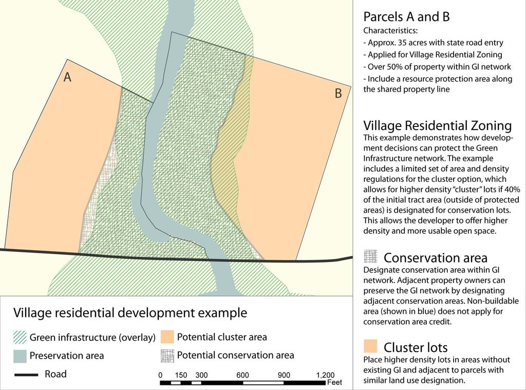
10 Traditional Development Cluster Development

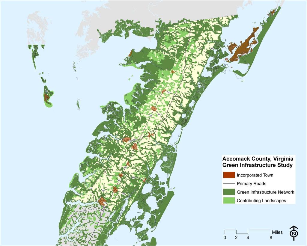
11 Here s the problem when cluster developments don t look outside the parcel:
12 Green infrastructure approach helps keep corridors intact. Undeveloped parcel: PDR, TDR, Easement?

13 Conserving working lands such as farms and forests, that contribute to the economy. Protecting and preserving water quality and supply. Providing cost-effective stormwater management and hazard mitigation. Preserving biodiversity and wildlife habitat. Improving public health, quality of life and recreation networks. Benefits of Green and Blue Infrastructure Plans

14 How will we use the maps and data? Park and open space planning Identify lands for PDR or TDR programs Heritage tourism and viewshed protection Forest planning and management Transportation planning: roads and trails New ordinance development Zoning basis for upzoning or downzoning Species protection (Delmarva fox squirrel) Public Regulatory Private Voluntary
15 15 Timeframe Task April June 2009 July Aug Sept. Dec Jan. Mar Mar. April 2010 Project Setup and Research Data Assessment Asset Maps Opportunity Maps Final Report Project Timeline & Tasks Outcomes Information gathering Meet with Board of Supervisors Tour Accomack County Create a project website GIS data gathering and preparation Conduct a literature review and create a research tracking tool Conduct stakeholder interviews Submit a Data Assessment summary memo Create a Green Infrastructure base map Create themed overlay maps to identify priority areas Review county zoning and development plans Create opportunity maps to illustrate key strategies for preserving and restoring green infrastructure Present asset maps on March 8 & 9 Present draft opportunity maps on March 10 Incorporate feedback from March meetings Develop a final report
16 16 Literature Review and Stakeholder Interviews
17 Literature Review: Recommendations 1. Reduce and filter agricultural nutrient applications. 2. Increase the spatial continuity of riparian systems. 3. Protect spatial continuity of coastal habitats 4. Isolate low-quality habitat patches (Phragmites patches, etc.). 5. Replace coastal habitats lost to erosion and inundation. 6. Protect groundwater recharge zone, and initiate water conservation and reuse programming. 7. Enhance dunes for shoreline protection and habitat expansion. * Recommendations in bold have spatial implications for the Green Infrastructure network. 17
18 18 Stakeholder Goals Considerations raised by stakeholders include: 1. Development patterns and infrastructure demands 2. Water quality and wastewater management 3. Conserving natural resources and wildlife 4. Identification of places with locally recognized environmental value 5. Access to recreation

19 19 Green Infrastructure Assets
20 20 Accomack County Assets Developing a green infrastructure network 1. Priority Conservation Area Assessment 2. Virginia Natural Landscape Assessment 3. Local Priorities
21 21 High Priority Conservation Areas + Connected, High Quality Landscapes + Contributing Landscapes Base Green Infrastructure Network
22 22
23 23 Local Priority Landscapes Shoreline Complex Includes Bayside and Seaside Zones Storm protection, tidal wetlands, erosion and accretion Terrestrial Zone Where people live Groundwater source Connect bayside and seaside zones
24 24

25 25 Asset Overlay Maps
26 26 Asset Themes or Overlays Habitat & Wildlife Conservation Water Quality Working Lands & Waters Recreation Access and Trails Cultural Resources / Sense of Place
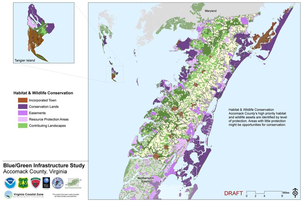
27 27 Habitat & Wildlife Conservation The GI Network identifies priority habitat and wildlife conservation areas Understanding what is already protected or least likely to change can help identify areas that require special attention or targeted conservation activities
28 28
29 29 Water Quality Landscape components that contribute to water quality include: Riparian buffers Forested watersheds Protected headwater areas and wetlands Protected wellheads
30 30
31 31 Working Lands: Agriculture Landscape components include: Prime soils for agriculture Existing Agriculture/Forestal Districts (AFD)
32 32
33 33 Working Lands: Forestry Landscape components include: Forest cover Tidal Marshes Identification of forested parcels in the GI network large enough to manage for both forestry and wildlife
34 34
35 35 Working Lands: Fisheries Working water assets support the local fishery and recreational economies Components include: Water access points Watersheds Submerged Aquatic Vegetation Oyster and clam beds Fishery management areas
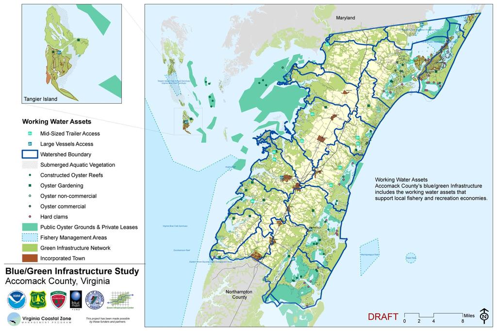
36 36
37 37 Recreation Access & Trails Nature-based recreational assets include: Conservation lands with public access Parks Birding and wildlife trails Water trails Water access points
38 38
39 39 Cultural Resources Natural landscapes provide important context and scenic qualities to heritage and cultural resources Existing historic districts and buildings Cultural events Scenic roads Tangier Island Viewsheds
40 40
41 41 Opportunity Map Preview
42 GI Opportunity Maps Development Scenario: Designate conservation areas to strategically preserve and link existing green infrastructure assets. Addresses the following literature review recommendations: Increase spatial continuity of riparian systems Protect groundwater recharge zone Protect spatial continuity of coastal habitats Enhance dunes for shoreline protection and habitat expansion Addresses the following stakeholder considerations: Development patterns and infrastructure demands Water quality Conserving natural resources and habitat Access to recreation 42
43 43

44 44 Discussion and Next Steps
45 45 Next Steps Present draft Opportunity Maps to the Board of Supervisors and Zoning Board on March 10th Incorporate feedback from March 8-9 meetings into asset maps Incorporate feedback from March 10 th meeting into opportunity maps Develop a final report

46 GIC Inc. The End 921 Second St. SE Charlottesville, VA , #222
Conservation Corridor Planning and Green Infrastructure Themes
 Conservation Corridor Planning and Green Infrastructure Themes Prepared by the Green Infrastructure Center Inc. and the Northern Virginia Regional Commission February 22, 2011 Brief Overview Project Background
Green Infrastructure Policies and Ordinances
 Green Infrastructure Policies and Ordinances October 23, 2013 By Karen Firehock, Green Infrastructure Center 2013 Georgia Urban Forest Council s 23 rd Annual Conference The mission of the nonprofit Green
Conservation Corridor Base and Thematic Maps
 Conservation Corridor Base and Thematic Maps August 20, 2010 This project is funded in part by the Virginia Coastal Zone Management Program at the Department of Environmental Quality through Grant #NAO9NOS4190163
Using Green Infrastructure Planning To Support And Enhance Healthy Ecosystems and Communities
 Using Green Infrastructure Planning To Support And Enhance Healthy Ecosystems and Communities by Karen Firehock, Executive Director Green Infrastructure Center Inc. www.gicinc.org A Presentation to Master
Green (and blue) Infrastructure Planning in VA
 Infrastructure Planning in VA") Green (and blue) Infrastructure Planning in VA Presentation to Rural Resiliency Forum By Karen Firehock Oct. 23, 2018 Green Infrastructure Center 2018 Slide Show Topics Definitions: Resilience Green Infrastructure
Green (and blue) Infrastructure Planning in VA Presentation to Rural Resiliency Forum By Karen Firehock Oct. 23, 2018 Green Infrastructure Center 2018 Slide Show Topics Definitions: Resilience Green Infrastructure
Presentation Outcomes
 Green Infrastructure Rappahannock-Rapidan Living Lands Planning Workshop September 17, 2009 Presentation Outcomes Define green infrastructure principles and concepts (video). How are green infrastructure
Green Infrastructure. by Karen Engel, NYS DEC. NYS Department of Environmental Conservation
 Green Infrastructure by Karen Engel, NYS DEC What is Green Infrastructure? For some it s all about water Green Infrastructure techniques use soils and vegetation to infiltrate, evapotranspirate, and/or
Planning for Staten. Habitat Restoration and Green Infrastructure. Island s North Shore
 Habitat Restoration and Green Infrastructure Planning for Staten Island s North Shore Community Board 1 March 1, 2018 NYC Parks Forestry, Horticulture, and Natural Resources Funded by the NYS Department
Central Lake Ontario Conservation Conservation Lands Master Plan
 Conservation Lands Master Plan Top 13 Frequently Asked Questions 1. What are conservation lands? Where are these conservation lands located in the Central Lake Ontario Conservation watershed? Conservation
Countywide Green Infrastructure
 Montgomery County s Countywide Green Infrastructure F U N C T I O N A L M A S T E R P L A N The Maryland National Capital Park and Planning Commission INFRASTRUCTURE An underlying base or foundation especially
Contents Introduction: Strategic Plan Why Focus on Green Infrastructure? Who Does GIC Serve?... 4
 2013-16 [STRATEGIC PLAN] The Green Infrastructure Center created its second strategic plan in 2013. The GIC is now expanding to new regions and developing new methods to advance the field of green infrastructure
NEW GRANTS PROGRAM. Today I will describe what green infrastructure planning entails, how the model works and the importance of the work to planners!
 NEW GRANTS PROGRAM The South Carolina Forestry Commission received funds from the USDA Forest Service s Southern Region to build a green infrastructure landscape scale model and to fund several implementation
Map Development 5/15/2012. New Virginia Modeling Tools
 Regional Green Infrastructure Base Map Development 5/15/2012 RRRC Land Use & Environment Committee New Virginia Modeling Tools VA Natural Landscape Assessment Forest Habitats Cultural Model Historic Resources
National Association of Conservation Districts. Kris Hoellen Vice President, Sustainable Programs The Conservation Fund September 19, 2013
 National Association of Conservation Districts Kris Hoellen Vice President, Sustainable Programs The Conservation Fund September 19, 2013 Our Mission The Conservation Fund forges partnerships to conserve
City of Missoula and Missoula County Open Space Planning Open House
 City of Missoula and Missoula County Open Space Planning Open House FEBRUARY 6, 2018 The following slides contain the display board content from the open house. Please use boards to answer questions in
Regional Open Space Conservation Plan. Regional Staff Committee January 18, 2018
 Regional Open Space Conservation Plan Regional Staff Committee January 18, 2018 Schedule We are here Task 1 - Stakeholder Input & Work Plan Dev. v z 2016 2017 2018 Oct Nov Dec Jan Feb Mar Apr May Jun Jul
Recommendations for Municipalities
 Protecting the Kayaderosseras Creek through Better Buffers Recommendations for Municipalities Conservation Committee October 2005 Introduction The Kayaderosseras Creek is a superb natural resource that
One County s Success in Linking Watershed Protection and Land Use Planning
 One County s Success in Linking Watershed Protection and Land Use Planning Bob Thompson Porter County Plan Commission March 28, 2012 Indiana Watershed Leadership Academy Population 160,000 Approximately
TOWN OF BETHLEHEM OPEN SPACE CONSERVATION PLAN PUBLIC MEETING: OCTOBER 12, 2017
 TOWN OF BETHLEHEM OPEN SPACE CONSERVATION PLAN PUBLIC MEETING: OCTOBER 12, 2017 Welcome and Agenda 6:00 6:45: Open House, Part One 6:45 7:15: Presentation and Questions 7:15 8:00: Open House, Part Two
Community Conservation Workshop. Saranac River Basin Communities
 Community Conservation Workshop Saranac River Basin Communities 2 Community Conservation Program Welcome! We have designed a Community Conservation Program that listens to the needs of community members.
Surrey Ecosystem Management Study
 Surrey Ecosystem Management Study Green Infrastructure Network Opportunities Public Open House & Information Session June 24 th, 2010 EMS Process Ecological Inventory Ecological Assessment Management Policy
Executive Summary Purpose of the Plan Defining Open Space and Greenways
 Executive Summary Bucks County possesses a vast array of open space resources including natural areas, parks, farmland and historic and cultural resources that contribute to a high quality of life valued
Township of Adjala-Tosorontio Official Plan Review. Natural Heritage
 Township of Adjala-Tosorontio Official Plan Review 13 Natural Heritage Introduction What is an Official Plan? An official plan is a municipal policy document which sets out the community s vision and strategies
Green Infrastructure. NYS Department of Environmental Conservation
 Green Infrastructure Green infrastructure is an interconnected network of natural areas and open spaces that sustains ecosystems. Benedict, M.A. and E.T. McMahon. 2006. Green Infrastructure Linking Landscapes
Introduction. Integrating Ecological Restoration of Estuarine Shorelines with Urban Community Revitalization Efforts. Ed Morgereth Biohabitats, Inc.
 Introduction Integrating Ecological Restoration of Estuarine Shorelines with Urban Community Revitalization Efforts Ed Morgereth Biohabitats, Inc. 5 th National Conference & Expo on Coastal and Estuarine
Building Ecological Solutions to Coastal Community Hazards: Guidance and NJ Coastal Community Assistance
 Building Ecological Solutions to Coastal Community Hazards: Guidance and NJ Coastal Community Assistance Stacy Small-Lorenz National Wildlife Federation Restore America s Estuaries Summit New Orleans,
Green Infrastructure Planning for Sustainability and Resiliency
 Green Infrastructure Planning for Sustainability and Resiliency Linking Lands and Communities in the Land-of-Sky Region SAMAB Conference - November 18, 2010 www.linkinglands.org Linda Giltz, AICP, Regional
Staff will be providing an overview of the project need, purpose and intent for consideration as part of the Amendment cycle.
 Agenda Item D-2 City of Tacoma Planning and Development Services To: Planning Commission From: Stephen Atkinson, Planning Services Division Subject: Open Space Corridors Project Meeting Date: March 1,
A Joined-up Regional Landscape: A Roadmap to connect the parts
 Breaking the Barriers: Engineering Solutions to Ecological Problems A Joined-up Regional Landscape: A Roadmap to connect the parts Associate Professor Darryl Low Choy Urban Research Program Outline Nature
Virginia Beach and Sea Level Rise: Where Do We Go From Here?
 Virginia Beach and Sea Level Rise: Where Do We Go From Here? Clay Bernick City of Virginia Beach Environment & Sustainability Office Bayfront Advisory Committee Presentation July 19, 2012 Five Items to
TOWN OF SPRINGFIELD, NEW HAMPSHIRE
 TOWN OF SPRINGFIELD, NEW HAMPSHIRE NATURAL RESOURCES INVENTORY EXECUTIVE SUMMARY March 2008 Prepared by: Watershed to Wildlife, Inc. Natural Resource Consultants 42 Mill Street, Suite 3 Littleton, NH 03561
Oakland County s Green Infrastructure Vision. L. Brooks Patterson Oakland County Executive
 Oakland County s Green Infrastructure Vision L. Brooks Patterson Oakland County Executive Southeast Michigan 20 miles northwest of Detroit Consists of 910 square miles Population of 1.2 million More than
Terra Nova Rural Park Plan
 Terra Nova Rural Park Plan Part 1 Getting to know the land The Surrounding Area North Side Airport, River, Trail East Side - Residential West Side- Sturgeon Banks, West Dyke Trail South Side:Terra Nova
Aquatic, Terrestrial and Landscape Conservation Design Tools and Products of the North Atlantic LCC
 Aquatic, Terrestrial and Landscape Conservation Design Tools and Products of the North Atlantic LCC Scott Schwenk Science Coordinator, North Atlantic LCC Chesapeake Bay FWS Partners Meeting Annapolis,
Infrastructure, Development and Enterprise Services. Natural Heritage Action Plan (NHAP) Project Initiation
 Project Initiation") Staff Report To Service Area Committee of the Whole Infrastructure, Development and Enterprise Services Date Monday, March 6, 2017 Subject Natural Heritage Action Plan (NHAP) Project Initiation Report
Staff Report To Service Area Committee of the Whole Infrastructure, Development and Enterprise Services Date Monday, March 6, 2017 Subject Natural Heritage Action Plan (NHAP) Project Initiation Report
This page intentionally blank.
 This page intentionally blank. Parks, Recreation, and Open Space Chapter Relationship to Vision Vision Parks, Recreation and Open Space Chapter Concepts County Government. County government that is accountable
STEWARDSHIP OF LONG ISLAND SOUND S ECOLOGICAL AND RECREATIONAL RESOURCES
 STEWARDSHIP OF LONG ISLAND SOUND S ECOLOGICAL AND RECREATIONAL RESOURCES Robin Kriesberg, Save the Sound, Inc. Thomas Halavik, US Fish and Wildlife Service Coastal Program An Initiative to Identify, Protect
Scarborough Waterfront Project
 Scarborough Waterfront Project Public Information Centre #1 Environmental Assessment Terms of Reference September 10, 2014 Agenda Open House Presentation 7:00 to 7:30 pm Presentation 7:30 to 8:15 pm History
Introducing Green Infrastructure for Coastal Resilience
 Introducing Green Infrastructure for Coastal Resilience National Oceanic and Atmospheric Administration (NOAA) Office for Coastal Management Gloucester, MA Office of Travel Courtesy, Tim Grafft What Is
Mapping and Planning for Green Infrastructure
 Mapping and Planning for Green Infrastructure Karen Firehock, Executive Director TransportiCA Webinar Series August 30, 2018 Today 1. Green infrastructure defined 2. Mapping green infrastructure in rural
Community Conservation Workshop. Lake Placid
 Community Conservation Workshop Lake Placid 2 Community Conservation Program Welcome! We have designed a Community Conservation Program that listens to the needs of community members. We are conducting
CREATING GREEN INFRASTRUCTURE FOR IRELAND
 CREATING GREEN INFRASTRUCTURE FOR IRELAND Dr William Hynes Downey Hynes Partnership 15 th September 2010 Overview of Presentation Definition of GI Legislation and Policy Background Examples of GI-type
Green Infrastructure Page 1
 Page 1 New Designs for Growth Planning with is an implementation resource publication of New Designs for Growth Guidebook. This publication was developed to aid local governments in their efforts to implement
Green Planning in Albemarle and Charlottesville
 Green Planning in Albemarle and Charlottesville Presentation to League of Women Voters February 10, 2019 By Karen Firehock, Executive Director Green Infrastructure Center 2019 The Green Infrastructure
CHAPTER 1 Introduction
 CHAPTER 1 Introduction From sea to summit, Lane County covers almost 4,800 square miles of diverse Oregon landscape. Stretching from the Pacific Ocean through the Coastal Range, the Willamette Valley to
Karen Firehock. Strategic. Green Infrastructure. Planning. a multi-scale approach
 Karen Firehock Strategic Green Infrastructure Planning a multi-scale approach STRATEGIC GREEN INFRASTRUCTURE PLANNING STRATEGIC GREEN INFRASTRUCTURE PLANNING: A multi-scale approach By Karen Firehock
Riparian Buffer on the Bushkill Creek. Policies
 Riparian Buffer on the Bushkill Creek Riparian buffers provide numerous benefits to landowners and the community by protecting groundwater recharge areas, providing flood control, providing stormwater
Planning for Staten. Habitat Restoration and Green Infrastructure. Island s North Shore
 Habitat Restoration and Green Infrastructure Planning for Staten Island s North Shore Walker Park December 7, 2017 NYC Parks Forestry, Horticulture, and Natural Resources Funded by the NYS Department of
Rhode Island Shoreline Change Special Area Management Plan
 Rhode Island Shoreline Change Special Area Management Plan Draft Document Outline REVISED 10/12/2017 VOLUME 1 Executive Summary & How to Use this Document (Draft by Dec 2017) 1. Introduction (Revised draft
Green or Grey Solutions? Why not both? Lessons from the Mid-Atlantic on Hybrid Living Shorelines
 Green or Grey Solutions? Why not both? Lessons from the Mid-Atlantic on Hybrid Living Shorelines Proactive By Design. Our Company Commitment Jesse Baldwin Coastal Geologist Project Manager GZA GeoEnvironmental,
4. What are the goals of the Kawarthas, Naturally Connected project? 7. What are watersheds and why are they being used as the project boundaries?
 Frequently Asked Questions (FAQs) 1. What are Natural Heritage Systems (NHS)? 2. Why are they important? 3. Which areas of the province have undertaken NHS projects? 4. What are the goals of the Kawarthas,
10.0 Open Space and Public Realm
 10.0 Open Space and Public Realm 10.0 Open Space and Public Realm The Public Open Space System is comprised of: outdoor spaces available for public use that are either publicly owned (e.g., parks and
Steering Committee 3. September 17, :30-7:30pm. Welcome.
 Steering Committee 3 September 17, 2015 5:30-7:30pm Welcome DOG RIVER www.makingwatershedswork.org Agenda 1. Welcome 2. Scientific Research: Water Quality 3. Current and Relevant Planning 4. Community
But What About the People? The Role of Urban Planning and Green Infrastructure
 But What About the People? The Role of Urban Planning and Green Infrastructure The Southeast Conservation Adaptation Strategy: A Model for Collaborative Conservation David Rouse, FAICP, ASLA Managing Director,
edmonton.ca/ribbonofgreen #ribbonofgreen
 WHAT IS THE RIBBON OF GREEN? The Ribbon of Green is Edmonton s entire river valley and ravine system. The Ribbon of Green (2018) Project will provide strategic guidance for the southwest and northeast
HAZARD MITIGATION GOALS AND OBJECTIVES
 SEWRPC Community Assistance Planning Report No. 282, 2nd Edition CITY OF MILWAUKEE ALL HAZARDS MITIGATION PLAN UPDATE Chapter IV HAZARD MITIGATION GOALS AND OBJECTIVES [NOTE: Throughout this plan update
Land Use Regional Planning in Alberta Collaborating with Stakeholders
 Land Use Regional Planning in Alberta Collaborating with Stakeholders Trevor Lema, Land & Integrated Management Planner September 2018 Overview Why Regional Planning? An Integrated Perspective Integrated
Meta-Analysis of Project Effectiveness: Learning at the Regional Scale
 Western Washington University Western CEDAR Salish Sea Ecosystem Conference 2014 Salish Sea Ecosystem Conference (Seattle, Wash.) May 1st, 10:30 AM - 12:00 PM Meta-Analysis of Project Effectiveness: Learning
{Best Practices. Summary of Tools, Strategies and Best Practices from 11 Michigan Case Study Communities
 Case Studies Michigan Coastal Community Working Waterfronts { Summary of Tools, Strategies and from 11 Michigan Case Study Communities Table of Contents Zoning...2 Community and Stakeholder Collaboration
OPEN SPACE CHAPTER 7: OVERVIEW. Preserve open space to protect natural resources, enhance character and provide passive recreation opportunities
 CHAPTER 7: OPEN SPACE OVERVIEW Ridgefield has made tremendous progress permanently preserving areas of town as open space. Open space preservation can serve many important purposes, including: protect
MAYFIELD WEST SECONDARY PLAN PHASE 2
 MAYFIELD WEST SECONDARY PLAN PHASE 2 Public Open House #3 February 25, 2010 Draft Preferred Land Use Scenario TOWN OF CALEDON PLANNING & DEVELOPMENT DEPARTMENT Open House Agenda TOWN OF CALEDON 1. Welcome
Town of Peru Comprehensive Plan Executive Summary
 Town of Peru Comprehensive Plan Executive Communities that plan grow by choice, not by chance. A plan makes growth thoughtful, understandable, and predictable. A plan shows that a community is managing
NJ Department of Environmental Protection
 NJ Department of Environmental Protection COASTAL AND LAND USE PLANNING New Jersey Coastal Management Program Covers NJ coastal waters to limit of tidal influence including 239 municipalities in 19 counties,
Port of San Diego Sea Level Rise Ad Hoc Committee Meeting 1 of 3.. September 18, 2018
 Port of San Diego Sea Level Rise Ad Hoc Committee Meeting 1 of 3. September 18, 2018 Agenda Welcome Introductions Rules of the Ad-Hoc Presentation Background Vulnerability Assessment Results Non-Agenda
Green Infrastructure Project Guidance
 OTHER OPTIONS Green Infrastructure Project Guidance Stakeholder Informed Introduction Green infrastructure is an approach to mitigating environmental challenges using vegetation, soils and natural processes
INTRODUCING THE BALTIMORE CITY GREEN NETWORK VISION PLAN
 INTRODUCING THE BALTIMORE CITY GREEN NETWORK VISION PLAN GOALS OF THE GREEN NETWORK PLAN Protect and enhance the unique ecological resources of our city Support economic growth and sustainable redevelopment
SUSTAINABILITY PLAN OTTAWA COUNTY PARKS AND RECREATION COMMISSION FALL 2017
 SUSTAINABILITY PLAN OTTAWA COUNTY PARKS AND RECREATION COMMISSION FALL 2017 Table of Contents Introduction Natural Resources Quality of Life Community Continuing the Mission Sustainability Measuring Sustainability
Planning for and Managing Open Space and Natural Areas
 Planning for and Managing Open Space and Natural Areas Increasingly, development proposals in Delaware include large amounts of open space and natural areas. While open space is important as a community
RURAL AREA PLAN IMPLEMENTATION
 RURAL AREA PLAN IMPLEMENTATION RAP AMENDMENTS SUMMARY OVERVIEW TOPICS COVERED 1. How We Got Here/Why This Is Important 2. RAP Process Overview 3. Updated Schedule 4. 1/10/17 BOC Meeting: FAQs 5. RAP Highlights
Describing the Integrated Land Management Approach
 Describing the Integrated Land Management Approach ISBN No. 978-0-7785-8902-0 (Online Edition) Pub No. I/422 What is Integrated Land Management? Integrated land management (ILM) is the strategic, planned
TreeTOPS: A Regional Urban Forest Initiative May 17, 2010 This plan made possible by:
 TreeTOPS: A Regional Urban Forest Initiative Regional Opportunities for Trees, Trails, and Open Space in Madera, Fresno, Kings, and Tulare Counties Central Valley, California May 17, 2010 This plan made
Working Group Meeting
 April 4,, 2017 Parks Operations Bldg Working Group Meeting Arts Districts Overview Stormwater/RPA/Stream Considerations First Principles Agenda 7:00pm 7:05pm 7:10pm 7:40pm 8:30pm 9:40pm 9:45pm Welcome
Stafford County Strategic Plans
 Stafford County Strategic s Strategic Department Description Date Adopted Board of Supervisors Priorities Fiscal Responsibility Education Public Safety Infrastructure Economic Development Service Excellence
Citywide Integrated Stormwater Management Plan (ISMP) DRAFT ACTION PLAN REVIEW Public Consultation November 16 th, 2016
 DRAFT ACTION PLAN REVIEW Public Consultation November 16 th, 2016") Citywide Integrated Stormwater Management Plan (ISMP) DRAFT ACTION PLAN REVIEW Public Consultation November 16 th, 2016 1 Agenda DRAFT ACTION PLAN REVIEW Public Consultation Time 6:00 6:05 6:05 6:20 6:20
Citywide Integrated Stormwater Management Plan (ISMP) DRAFT ACTION PLAN REVIEW Public Consultation November 16 th, 2016 1 Agenda DRAFT ACTION PLAN REVIEW Public Consultation Time 6:00 6:05 6:05 6:20 6:20
INTRODUCTION Key Issues and Findings Goals, Objectives, and Policies - Natural Resources - Map M18 - Environmental Resources
 Natural, Environmental, Cu INTRODUCTION This Element provides policies related to the preservation and protection of the Centre Region s natural, environmental, cultural, and historic resources. This Element
BRE Strategic Ecological Framework LI Technical Information Note 03/2016
 BRE Strategic Ecological Framework Technical Information Note 03/2016 September 2016 Contents 1. Introduction 2. Aims of BRE s Strategic Ecological Framework 3. How SEF is different from previous approaches
What is green Infrastructure (GI)?
?") GreenNet Workshop green Infrastructure, Goričko Nature Park (Slovenia), 11.09.2013 What is green Infrastructure (GI)? Mike Cattell Leidorf DEGES Frankenwaldtourismus Hofrichter Melanie Kreutz PP02, BUND-Project
GreenNet Workshop green Infrastructure, Goričko Nature Park (Slovenia), 11.09.2013 What is green Infrastructure (GI)? Mike Cattell Leidorf DEGES Frankenwaldtourismus Hofrichter Melanie Kreutz PP02, BUND-Project
Development of green infrastructure in EU regions Nature-based solutions delivering multiple benefits
 Development of green infrastructure in EU regions Nature-based solutions delivering multiple benefits A Policy Brief from the Policy Learning Platform on Environment Introduction What is green infrastructure?
Objectives and Strategies for the Integration of Recreation, Parks and Open Space in Regional Plans
 BULLETIN 2 Objectives and Strategies for the Integration of Recreation, Parks and Open Space in Regional Plans TABLE OF CONTENTS Introduction 3 Land-use Framework Outcomes 1 4-8 Land-use Framework Outcomes
This presentation has been developed by the Sustainable Sites Initiative for general audiences
 This presentation has been developed by the Sustainable Sites Initiative for general audiences Copyright 2011 by the Sustainable Sites Initiative. All rights reserved. 2011 2010 Sustainable Sites Initiative
The Salt Marsh Advancement Zone Assessment of Connecticut
 The Salt Marsh Advancement Zone Assessment of Connecticut Front cover image: Salt marsh advancement zones in Stratford, CT from the Comprehensive Map Book of Stratford, CT. Table of Contents Introduction...
Preparing Hudson River Waterfronts for an Era of Rapid Sea Level Rise
 Preparing Hudson River Waterfronts for an Era of Rapid Sea Level Rise CITY OF KINGSTON TIDAL WATERFRONT FLOODING TASK FORCE Gregg Swanzey Director, Office of Economic Development & Strategic Partnerships,
Lower Columbia River and Coastal Landscape Conservation Design
 Today s Presenters: Lower Columbia River and Coastal Landscape Conservation Design John Mankowski, North Pacific Landscape Conservation Cooperative Sara Evans-Peters, Pacific Birds Tom Miewald, US Fish
Lawrencetown Beach & Rainbow Haven Beach
 Lawrencetown Beach & Rainbow Haven Beach Public Engagement Session Wednesday, September 27 th, 2017 6:00pm 8:00pm Cole Harbour Place 51 Forest Hills Pkwy, Dartmouth Agenda Welcome & Introductions Overview
Chapter 2: Strategies for Local Governments Chapter 3: Site Assessment and Design for Low Impact Development. Break Out Group 10:30 am to 12 pm
 Chapter 2: Strategies for Local Governments Chapter 3: Site Assessment and Design for Low Impact Development Break Out Group 10:30 am to 12 pm A Low Impact Development Manual for Coastal South Carolina
Sunshine Coast Council Coastal Management Overview. January 2016 edition
 Sunshine Coast Council Coastal Management Overview January 2016 edition Mayor Mark Jamieson Mayor s foreword Our impressive beaches are fundamental to our Sunshine Coast lifestyle, economy and coastal
A Network Theory Framework for Urban Cultural Heritage Conservation. Manal Ginzarly LEMA, Université de Liège
 A Network Theory Framework for Urban Cultural Heritage Conservation Manal Ginzarly LEMA, Université de Liège Objective Develop an ecological approach to the integration of heritage conservation and urban
Greenways as an alternative to traditional infrastructure. Green Infrastructure
 Greenways as an alternative to traditional infrastructure Green Infrastructure What is a Greenway? Little (1990) - A linear open space along a natural or human made corridor. Fabos - linked corridors nature
TERRESTRIAL NATURAL HERITAGE SYSTEM STRATEGY APPENDIX F: MODEL POLICIES FOR THE IMPLEMENTATION OF THE TARGET TERRESTRIAL NATURAL HERITAGE SYSTEM
 TERRESTRIAL NATURAL HERITAGE SYSTEM STRATEGY APPENDIX F: MODEL POLICIES FOR THE IMPLEMENTATION OF THE TARGET TERRESTRIAL NATURAL HERITAGE SYSTEM C H A P T E R 1 M O D E L P O L I C I E S F O R I M P L
GREEN NETWORK APPLICATIONS IN ESTONIA
 GREEN NETWORK APPLICATIONS IN ESTONIA Kalev Sepp, Tuuli Veersalu, Martk Külvik Estonian University of Life Sciences 1 WHY? BACKGROUND - POLITICAL By adopting the Pan-European Biological and Landscape Diversity
Southwest Fleetwood Enclave
 Southwest Fleetwood Enclave Development Concept Plan Southwest Fleetwood Enclave 1 st Land Owners Meeting April 30 th, 2012 Presentation Overview Why the Plan? ; Overview & Purpose of Study; Constraints
Parks, Open Space and Trails
 Introduction Parks have often been referred as the lungs of our cities, cleansing the air of pollutants and particulate matter. Parks are also gathering places for families and community. They offer spaces
Overview of Southwestern Pennsylvania Commission s (SPC) 2040 Long Range Transportation Plan (LRTP)
 2040 Long Range Transportation Plan (LRTP)") Overview of Southwestern Pennsylvania Commission s (SPC) 2040 Long Range Transportation Plan (LRTP) Presented to Pennsylvania Agency Coordination Meeting May 27, 2015 Doug Smith & Ryan Gordon 1 Southwestern
Overview of Southwestern Pennsylvania Commission s (SPC) 2040 Long Range Transportation Plan (LRTP) Presented to Pennsylvania Agency Coordination Meeting May 27, 2015 Doug Smith & Ryan Gordon 1 Southwestern
Rural Land Use Designations Kittitas County December 6, 2007 Draft
 KITTITAS COUNTY COMMUNITY DEVELOPMENT SERVICES 411 N. Ruby St., Suite 2, Ellensburg, WA 98926 CDS@CO.KITTITAS.WA.US Office (509) 962-7506 Fax (509) 962-7682 Rural Land Use Designations Kittitas County
WASHINGTON COUNTY OREGON
 WASHINGTON COUNTY OREGON LONG RANGE PLANNING DIVISION North Bethany Subarea Stream Corridors: Existing Regulations In Oregon, there is a distinct difference between the land use rules that apply in rural
Principles for Ecological Landscape Design in Brownfield Business Parks
 Principles for Ecological Landscape Design in Brownfield Business Parks Part of USDA Forest Service research project # 00-JV-11231300-033: Aligning Social and Ecological Drivers of Urban Landscape Change
City of Surrey Ecosystem Management Study. Integration of ecological processes with land use
 City of Surrey Ecosystem Management Study Integration of ecological processes with land use Natural areas in Surrey are changing as the City grows and evolves. Many important natural areas remain or may
APWA Expo August 27, Ground Water Recharge With Storm Management: A Sustainable Development
 APWA Expo August 27, 2013 Ground Water Recharge With Storm Management: A Sustainable Development Presented by: Joel S. Koenig, P.E. Andrew J. Hawkins Chris P. Dagiantis, P.E., CFM Bios Joel S. Koenig,
INTEGRATING PROTECTED AREAS INTO THE WIDER LANDSCAPE, SEASCAPE AND RELATED SECTORS. An Overview
 INTEGRATING PROTECTED AREAS INTO THE WIDER LANDSCAPE, SEASCAPE AND RELATED SECTORS An Overview USING AN EXAMPLE FROM NORTHEAST US Relationship of IPAWLS guide to other planning and assessment processes
Environment and Sustainability. Environment and Sustainability
 4 Environment and Sustainability Environment and Sustainability ENVIRONMENT AND SUSTAINABILITY 4.1 CLIMATE CHANGE AND AIR QUALITY... 4-5 4.1.1 OBJECTIVES... 4-6 4.1.2 POLICIES... 4-6 4.2 NATURAL HERITAGE