Green (and blue) Infrastructure Planning in VA
|
|
|
- Chrystal Jordan
- 5 years ago
- Views:
Transcription


1 Green (and blue) Infrastructure Planning in VA Presentation to Rural Resiliency Forum By Karen Firehock Oct. 23, 2018 Green Infrastructure Center 2018

2 Slide Show Topics Definitions: Resilience Green Infrastructure Benefits of GI Planning Example: Albemarle Applications and Discussion

3 The Green Infrastructure Center helps communities evaluate their green assets to maximize ecological, economic and cultural returns. We do this by: Building landscape models Teaching courses and workshops Research into new methodologies Helping communities create strategies


4 Some examples of GIC s work in rural landscapes Albemarle County, VA Darlington County, SC Accomack County, VA Ulster County, NY Connecting and conserving intact landscapes to conserve biodiversity, clean water and cultural landscapes. Protecting the cultural of hunting, fishing and farming in a historic landscape of the rural South. Conserving green infrastructure in the face of rising seas and protecting the fisheries of the Chesapeake Bay. Protecting world class ecosystems and water for New York City and towns in the Hudson River Valley.

 has a national")
5 GIC created state guides and models for green infrastructure planning at the national, state and county scale. Our state guide (left) discusses Virginia s state green infrastructure model and our national book (right) has a national focus and more urban examples.


6 Term Origin Florida coined the term Green Infrastructure. in a 1994 report to the governor on land conservation strategies. The intention was to show that natural systems are important components of our infrastructure. They built a state model to find priorities.
 shows a neighborhood s gray infrastructure including buildings and roads.")
7 Definition: What is green infrastructure? A map of a city for one of GIC s projects (left) shows a neighborhood s gray infrastructure including buildings and roads. Classified high-resolution satellite imagery (right) adds a green infrastructure data layer (trees and other vegetation).

8 Benefits of Conserving Green Infrastructure Preserving biodiversity and wildlife habitat. Conserving working lands such as farms and forests, that contribute to the economy. Protecting and preserving water quality and supply. Providing cost-effective stormwater management and hazard mitigation. Improving public health, quality of life and recreation networks.

 Conserve natural green infrastructure (trees, forests, wetlands)")

9 Green Infrastructure: You may have heard of this as raingardens, bioswales or green rooftops. This is constructed green infrastructure for stormwater management. EPA added this idea in 2006 to the definition. The key is to 1) Conserve natural green infrastructure (trees, forests, wetlands) 2) Protect and connect the landscape 3) Build in the least impactful manner 4) Then mitigate impacts with best management practices First conservation, then mitigation. Rain gardens Green Rooftops Filterra Boxes


10 Trees: the original best green infrastructure! Trees give us cleaner air, shade, beauty and stormwater benefits at a cost that is far cheaper than engineered systems! Estimates for the amount of water a typical street tree can intercept in its crown, range from 760 gallons to 4000 gallons per tree per year, depending on species. GIC is studying the role of trees for stormwater management in 6 states and 12 cities. In VA they are Harrisonburg, Lynchburg and Norfolk. VA DOF and USFS fund this work!
 The amount of change the system can undergo and still retain the same controls on structure and function.")

11 What is resilience? Resiliency has three characteristics: 1) The amount of change the system can undergo and still retain the same controls on structure and function. 2) The degree to which the system is capable of self organization. 3) The ability to build and increase the capacity for learning and adaptation. Ensuring clean water supplies with forested buffers at Totier Creek Reservoir Park In short, identifying what to protect or restore and taking direct action to do so builds resilience! Re-building resiliency by restoring native shorelines to buffer storms and clean water in Virginia s coastal plain


12 Green Infrastructure Planning Requires Thinking About How to Connect the Landscape It s about connecting the landscape! Not just key habitat patches but how we connect them! The more connected the landscape, the more resilient it is!


13 Who Prefers Interior Forest Cores? Birds, e.g. cerulean warbler, Scarlet tanager Mammals, e.g. black bear, bobcat, n. flying squirrel Amphibians, e.g. spotted salamander GREEN INFRASTRUCTURE CENTER
14 We need to protect habitat cores to conserve interior habitats. Take the average tree height 100 feet and multiply by 3 to get edge. Subtract that to learn what remains and whether there is enough area to constitute a core. If smaller, it may still be a key patch or site. Interior = Total Area 3(h)

15 GICINC.ORG GREEN INFRASTRUCTURE CENTER How we evaluate the quality of habitat cores = Core Metrics Total Area & Area of Interior Forest Soil Productivity Index Depth of Interior Area of Wetlands Stream Conservation Units Core Topographic Diversity Rare, Threatened, Endangered species Area of Surface Water/Aquatic Habitat Length of Streams Within Interior Forest Landscape Diversity

16 Corridors Connect Cores The ideal is 100 meters of safe space in the middle and 100 meters of edge. minimum width = 300 meters wide


")

17 Who Can Use the Corridors? (300 meters is ideal )


18 Wildlife Crossings Crab bridge at Christmas Island, Austrailia Rendering of crossing over highway 101 in Agoura Hills, CA. Construction proposed in 5 years: 200 L by 165 W Design Resources: Netherlands

19 When direct corridors are lost, some species can still hop across.

20 If cores or patches are too far apart, or if a core is lost, species may become isolated and decline over time. GREEN INFRASTRUCTURE CENTER However, sometimes when cores are lost, species may decline Isolation = less resilience
 Review Data What do we know or need to know, to map identified values? 3) Map Your Community s Ecological and Cultural Assets Based on the goals established in Step One and data from Step Two.")
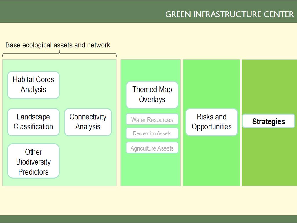
21 Six Steps for Green Infrastructure Planning GREEN INFRASTRUCTURE CENTER 1) Set Your Goals: What does your community/organization value? 2) Review Data What do we know or need to know, to map identified values? 3) Map Your Community s Ecological and Cultural Assets Based on the goals established in Step One and data from Step Two. 4) Risk Assessment What assets are most at risk and what could be lost if no action is taken? 5) Rank Your Assets and Determine Opportunities Based on those assets and risks you have identified, which ones should be restored or improved? 6) Implement Opportunities Include natural asset maps in both daily and longrange planning (park planning, comp plans, zoning, tourism and economic development, seeking easements etc)


22 Virginia Natural Landscape Assessment a landscape-scale GIS analysis for identifying, prioritizing, and linking natural habitats in Virginia. Download the data for free!

23
24 Green Infrastructure Planning Applications Zoning Tools and Comp Plans Park and open space planning I.d. lands for PDR or TDR programs New ordinance development Species protection Heritage tourism and viewsheds Ag and Forestall Districts Easements Transportation plans: roads/trails Land management Public Regulatory Private Voluntary
25


26 Case Example: Albemarle County, VA Connecting and conserving intact landscapes to conserve biodiversity, clean water and livability. GIC has conducted more than 20 projects in VA. Today we will show Albemarle County which received technical assistance from GIC for green infrastructure planning. Funded by a technical assistance grant from the USDA Forest Service and the Virginia Department of Forestry. Albemarle County matched the grant with in-kind (staff and volunteer hours).


27 Albemarle Model: improves on the state model by creating a finer grained picture using 1 meter resolution rather than 30 meters. At 726 square miles, the county is one of the largest in Virginia. We can t survey every inch of the county we can model the habitat that is most likely to support native species.
28
29 Mapping Process GREEN INFRASTRUCTURE CENTER

30 A landscape from above (complexity!)

31 Land Cover

32 Where is the interior habitat? Identify Distinct Habitat Cores, and Supporting Fragments

33 Countywide Summary 179 areas meet the criteria for core habitat (> 100 contiguous acres of interior forest) This area accounts for 44% of forested land in the county Habitat Fragment = acres Small = acres Medium = 1,000 10,000 acres Large = 10,000 acres or larger

34 Dark green = Park Pink = Conservation easement Orange = Open space use agreement parcels Light blue = Water protection ordinance buffers


35 Cores Will Need to Be Updated


36 Results help to place site-scale surveys in context Biodiversity Work Group Important Sites in Orange

37 Which Cores are Most Important for Connectivity?

38 Habitat maps can be used to inform comprehensive plans, transportation plans, economic development plans and more. Strategy 4g: Provide information to potential land subdividers on the importance of protecting habitat when creating lots for development.


39 Even Green in infrastructure developed landscapes, plans connect we corridors can keep before habitat development connected and drainages intact, but only if we plan at a larger scale.
40
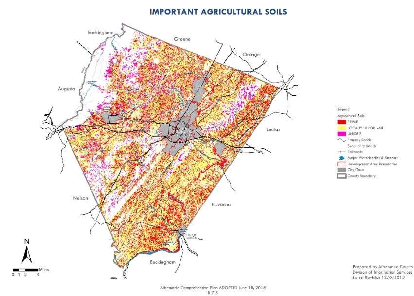
41 Agriculture Assets in Context

42 Agriculture Assets in Context


43 Collection of Naturebased Recreation Data Popular running routes were created by GIC to better represent recreation assets in the county
44 Wineries, Cideries, and Breweries Can be landscape dependent as people visit them for beverages and views! Part of the rural area economy

45 Drinking Water How does the landscape support water quality and drinking water sources?

46 Historic Resources with Landscape Context Rural historic districts National Register Sites House museums Scenic byways Scenic rivers

47 Ex: Comp Planning Habitat maps can be used to inform comprehensive plans, transportation plans, industrial development plans and more. Albemarle County VA is using the maps to inform future growth and development.
48 Relation to Comprehensive Plan: Albemarle s ecosystems and natural resources will be thoughtfully protected and managed in both the Rural and Development Areas to safeguard the quality of life of present and future generations. Strategy 4a: Develop an Action Plan for Biodiversity to protect significant areas of biological importance in the County. Strategy 4b: Regularly repeat the land use/land-cover datagathering process (as begun in 2009) for the purpose of monitoring landscape changes

49 Strategy 4a and 4b have now been achieved! Data and maps have been created to inform the new Biodiversity Action Plan and will inform future updates to the comprehensive plan. Maps can be used for daily planning in working with landowners and developers to conserve as much intact and connected high value landscape as possible.

")
50 CP Obj. 4: Protect the biological diversity and ecological integrity of the County in both the Rural Area and Development Areas. Locally endangered examples: James spiny mussel (Pleurobema collina) Northern Long eared bat (Myotis septentrionalis) Protect RTE + preventing listings!

51 Protecting Water Supply Forests also protect surface water sources and aquifer recharge zones and reduce the cost of drinking water treatment. GREEN INFRASTRUCTURE CENTER American Water Works Association found a 10% increase in forest cover reduced treatment costs for drinking water by 20%. (Ernst et al. 2004) Intact Forests Protect Water Supply and = cheaper water treatment Totier Creek Reservoir, Albemarle CP Objective 1: Ensure clean and abundant water resources for public health, business, healthy ecosystems, and personal enjoyment by preventing shortages and contamination.

52 Protecting Air Quality CP Obj 2: Protect air quality. Forests remove volatile organic compounds, particulate matter and sequester carbon trees are the lungs of Albemarle County. Even at the neighborhood scale, trees significantly improve air quality. Well treed landscapes = healthier communities.

53 Green Assets = Real Estate $$$ $ Having a park within 1,500 feet of a home increased its sale price between $845 - $2,262 (in 2000 dollars). Economic Benefits of Recreation, Open Space, Recreation Facilities and Walkable Community Design, 2010 $ The larger the park, the more significant the property value increase. (ibid) Parks = better tax base = $! $ Large natural forest areas have a greater positive impact on nearby property prices than smaller urban parks or developed parks such as playgrounds, skate parks or golf courses. Bigger intact forests/natural areas = more $! GREEN INFRASTRUCTURE CENTER

54 Job development Small companies, especially those that are have well paid and skilled workforce place a strong importance on the green of the local environment. Crompton Love and Moore, 1997 The creative class: artists, media, lawyers, analysts, make up 30 percent of the U.S. workforce and they place a premium on outdoor recreation and access to nature. Florida, 2002 Natural assets attract better paid jobs and thus a better tax base = $


55 The maps can help inform where future parks might be located based on population centers, need to protect key habitats or species, opportunities to increase recreation or site interpretation. GREEN INFRASTRUCTURE CENTER Park and Open Space Planning

56 Heritage Tourism GREEN INFRASTRUCTURE CENTER Heritage Tourists spend on average about 2.5 times more than all other types of tourists. They want to hike, see and touch history and they prefer to stay in close to where they visit. CP Economic Development Strategy 1c: Promote tourism that helps preserve scenic, historic, and natural resources.


57 Viewshed Protection For tourism and heritage, identify views where visual character is important. GIS tools, such as spatial analyst can create a digital elevation model to understand what is visible from where. While voluntary, more analysis could be conducted. Monticello has worked with local developers to disguise rooftops and minimize building visibility.

58 Considerations for the Urban Ring Smaller scales still need open spaces In urban areas we focus on: Trees and woodlots Habitat patches Streams and wetlands Trails and smaller parks Still can connect to larger networks The goal was to protect the rural area and rural economy by encouraging growth in the urban ring and discouraging additional suburban developments in the rural area. And it s working!
59 In conclusion Identify the most important assets high quality ag soils, forests, views, water supply and recharge areas and ensure they are protected (buffer then, change zoning, add incentives, educate the public). Map the most important habitats and assets first plan for roads to avoid them and pathways to enjoy them. Adopt maps into your policy documents and add them to your county GIS use them everyday! Identify hazards and avoid building in those areas, let nature be your buffer (don t build in floodplains, avoid steep slops, cluster development and conserve open space).

60 GIC Inc. 440 Premier Circle, Suite 220 Charlottesville, VA,
Green Planning in Albemarle and Charlottesville
 Green Planning in Albemarle and Charlottesville Presentation to League of Women Voters February 10, 2019 By Karen Firehock, Executive Director Green Infrastructure Center 2019 The Green Infrastructure
Green Infrastructure Policies and Ordinances
 Green Infrastructure Policies and Ordinances October 23, 2013 By Karen Firehock, Green Infrastructure Center 2013 Georgia Urban Forest Council s 23 rd Annual Conference The mission of the nonprofit Green
Conservation Corridor Planning and Green Infrastructure Themes
 Conservation Corridor Planning and Green Infrastructure Themes Prepared by the Green Infrastructure Center Inc. and the Northern Virginia Regional Commission February 22, 2011 Brief Overview Project Background
Blue/Green Infrastructure Study Accomack County, VA
 Blue/Green Infrastructure Study Accomack County, VA Draft Asset Maps March 8-9, 2010 Green Infrastructure Center, Inc. 2 Overview What is Green and Blue Infrastructure Project Timeline & Tasks Literature
Green Infrastructure. by Karen Engel, NYS DEC. NYS Department of Environmental Conservation
 Green Infrastructure by Karen Engel, NYS DEC What is Green Infrastructure? For some it s all about water Green Infrastructure techniques use soils and vegetation to infiltrate, evapotranspirate, and/or
Mapping and Planning for Green Infrastructure
 Mapping and Planning for Green Infrastructure Karen Firehock, Executive Director TransportiCA Webinar Series August 30, 2018 Today 1. Green infrastructure defined 2. Mapping green infrastructure in rural
NEW GRANTS PROGRAM. Today I will describe what green infrastructure planning entails, how the model works and the importance of the work to planners!
 NEW GRANTS PROGRAM The South Carolina Forestry Commission received funds from the USDA Forest Service s Southern Region to build a green infrastructure landscape scale model and to fund several implementation
Using Green Infrastructure Planning To Support And Enhance Healthy Ecosystems and Communities
 Using Green Infrastructure Planning To Support And Enhance Healthy Ecosystems and Communities by Karen Firehock, Executive Director Green Infrastructure Center Inc. www.gicinc.org A Presentation to Master
Conservation Corridor Base and Thematic Maps
 Conservation Corridor Base and Thematic Maps August 20, 2010 This project is funded in part by the Virginia Coastal Zone Management Program at the Department of Environmental Quality through Grant #NAO9NOS4190163
Map Development 5/15/2012. New Virginia Modeling Tools
 Regional Green Infrastructure Base Map Development 5/15/2012 RRRC Land Use & Environment Committee New Virginia Modeling Tools VA Natural Landscape Assessment Forest Habitats Cultural Model Historic Resources
Planning for and Managing Open Space and Natural Areas
 Planning for and Managing Open Space and Natural Areas Increasingly, development proposals in Delaware include large amounts of open space and natural areas. While open space is important as a community
Contents Introduction: Strategic Plan Why Focus on Green Infrastructure? Who Does GIC Serve?... 4
 2013-16 [STRATEGIC PLAN] The Green Infrastructure Center created its second strategic plan in 2013. The GIC is now expanding to new regions and developing new methods to advance the field of green infrastructure
National Association of Conservation Districts. Kris Hoellen Vice President, Sustainable Programs The Conservation Fund September 19, 2013
 National Association of Conservation Districts Kris Hoellen Vice President, Sustainable Programs The Conservation Fund September 19, 2013 Our Mission The Conservation Fund forges partnerships to conserve
Green Infrastructure. NYS Department of Environmental Conservation
 Green Infrastructure Green infrastructure is an interconnected network of natural areas and open spaces that sustains ecosystems. Benedict, M.A. and E.T. McMahon. 2006. Green Infrastructure Linking Landscapes
Countywide Green Infrastructure
 Montgomery County s Countywide Green Infrastructure F U N C T I O N A L M A S T E R P L A N The Maryland National Capital Park and Planning Commission INFRASTRUCTURE An underlying base or foundation especially
INTRODUCING THE BALTIMORE CITY GREEN NETWORK VISION PLAN
 INTRODUCING THE BALTIMORE CITY GREEN NETWORK VISION PLAN GOALS OF THE GREEN NETWORK PLAN Protect and enhance the unique ecological resources of our city Support economic growth and sustainable redevelopment
Community Conservation Workshop. Lake Placid
 Community Conservation Workshop Lake Placid 2 Community Conservation Program Welcome! We have designed a Community Conservation Program that listens to the needs of community members. We are conducting
Staff will be providing an overview of the project need, purpose and intent for consideration as part of the Amendment cycle.
 Agenda Item D-2 City of Tacoma Planning and Development Services To: Planning Commission From: Stephen Atkinson, Planning Services Division Subject: Open Space Corridors Project Meeting Date: March 1,
This page intentionally blank.
 This page intentionally blank. Parks, Recreation, and Open Space Chapter Relationship to Vision Vision Parks, Recreation and Open Space Chapter Concepts County Government. County government that is accountable
Town of Peru Comprehensive Plan Executive Summary
 Town of Peru Comprehensive Plan Executive Communities that plan grow by choice, not by chance. A plan makes growth thoughtful, understandable, and predictable. A plan shows that a community is managing
Planning for Staten. Habitat Restoration and Green Infrastructure. Island s North Shore
 Habitat Restoration and Green Infrastructure Planning for Staten Island s North Shore Community Board 1 March 1, 2018 NYC Parks Forestry, Horticulture, and Natural Resources Funded by the NYS Department
DISCUSSION TOPIC: ST JOHNS RIVER & ITS TRIBUTARIES (BPII) 2030 COMPREHENSIVE PLAN POLICES AND REGULATORY FRAMEWORK
 2030 COMPREHENSIVE PLAN POLICES AND REGULATORY FRAMEWORK") DISCUSSION TOPIC: ST JOHNS RIVER & ITS TRIBUTARIES (BPII) 2030 COMPREHENSIVE PLAN POLICES AND REGULATORY FRAMEWORK St. John s River & Its Tributaries Issue Summary: The St. Johns River is an important
DISCUSSION TOPIC: ST JOHNS RIVER & ITS TRIBUTARIES (BPII) 2030 COMPREHENSIVE PLAN POLICES AND REGULATORY FRAMEWORK St. John s River & Its Tributaries Issue Summary: The St. Johns River is an important
COMMUNITY ENVIRONMENTAL MANAGEMENT
 COMMUNITY ENVIRONMENTAL MANAGEMENT CEM HANDBOOK FOR COMMUNITY CONSERVATION PLANNING ----- Draft ----- Prepared by the CENTER FOR COMMUNITY ENVIRONMENTAL MANAGEMENT in association with the NEW YORK STATE
Presentation Outcomes
 Green Infrastructure Rappahannock-Rapidan Living Lands Planning Workshop September 17, 2009 Presentation Outcomes Define green infrastructure principles and concepts (video). How are green infrastructure
Rural Land Use Designations Kittitas County December 6, 2007 Draft
 KITTITAS COUNTY COMMUNITY DEVELOPMENT SERVICES 411 N. Ruby St., Suite 2, Ellensburg, WA 98926 CDS@CO.KITTITAS.WA.US Office (509) 962-7506 Fax (509) 962-7682 Rural Land Use Designations Kittitas County
RECREATION, OPEN SPACE AND GREENWAYS ELEMENT GOALS, OBJECTIVES, AND POLICIES
 RECREATION, OPEN SPACE AND GREENWAYS ELEMENT GOALS, OBJECTIVES, AND POLICIES GOAL R-1: DEVELOP A RECREATION, OPEN SPACE AND GREENWAYS SYSTEM AS AN INTEGRAL COMPONENT OF AN OVERALL, COUNTY-WIDE ECONOMIC
Community Conservation Workshop. Saranac River Basin Communities
 Community Conservation Workshop Saranac River Basin Communities 2 Community Conservation Program Welcome! We have designed a Community Conservation Program that listens to the needs of community members.
STEWARDSHIP OF LONG ISLAND SOUND S ECOLOGICAL AND RECREATIONAL RESOURCES
 STEWARDSHIP OF LONG ISLAND SOUND S ECOLOGICAL AND RECREATIONAL RESOURCES Robin Kriesberg, Save the Sound, Inc. Thomas Halavik, US Fish and Wildlife Service Coastal Program An Initiative to Identify, Protect
Tackling Difficult SEQR Topics
 Presented by Nan Stolzenburg AICP CEP and Don Meltz AICP Tackling Difficult SEQR Topics COMMUNITY CHARACTER, HISTORIC/ARCHAEOLOGICAL RESOURCES & HABITATS/ENDANGERED SPECIES Training Agenda Introductions
SUSTAINABILITY PLAN OTTAWA COUNTY PARKS AND RECREATION COMMISSION FALL 2017
 SUSTAINABILITY PLAN OTTAWA COUNTY PARKS AND RECREATION COMMISSION FALL 2017 Table of Contents Introduction Natural Resources Quality of Life Community Continuing the Mission Sustainability Measuring Sustainability
Chapter 5: Natural Resources and Environment
 NATURAL RESOURCES AND ENVIRONMENT 5-1 5 Chapter 5: Natural Resources and Environment BACKGROUND AND INTENT Urban expansion represents the greatest risk for the future degradation of existing natural areas,
Greenways as an alternative to traditional infrastructure. Green Infrastructure
 Greenways as an alternative to traditional infrastructure Green Infrastructure What is a Greenway? Little (1990) - A linear open space along a natural or human made corridor. Fabos - linked corridors nature
Terra Nova Rural Park Plan
 Terra Nova Rural Park Plan Part 1 Getting to know the land The Surrounding Area North Side Airport, River, Trail East Side - Residential West Side- Sturgeon Banks, West Dyke Trail South Side:Terra Nova
Minnesota Department of Natural Resource - Natural Resource Guidance Checklist Conserving Natural Resources through Density Bonuses
 Minnesota Department of Natural Resource - Natural Resource Guidance Checklist Conserving Natural Resources through Density Bonuses NRDB Why Use Density Bonuses & This Checklist Local units of government
Riparian Buffer on the Bushkill Creek. Policies
 Riparian Buffer on the Bushkill Creek Riparian buffers provide numerous benefits to landowners and the community by protecting groundwater recharge areas, providing flood control, providing stormwater
Gloucester County s Comprehensive Plan. The Community Connection
 Gloucester County s Comprehensive Plan The Community Connection Current Comp Plan Adopted in 1991 with a 20 year planning horizon Updated in 1995 with Part V- Implementation Recommendations and Appendix
APPENDIX I Presentations
 APPENDIX I Presentations Workshop Summary Report 11 Peel Region Official Plan Review May 5, 2010 Compatible Active Recreation Workshop July 29, 2010 Components of PROPR Sustainability Planning Tools/Updates
OPEN SPACE CHAPTER 7: OVERVIEW. Preserve open space to protect natural resources, enhance character and provide passive recreation opportunities
 CHAPTER 7: OPEN SPACE OVERVIEW Ridgefield has made tremendous progress permanently preserving areas of town as open space. Open space preservation can serve many important purposes, including: protect
Planning Academy MARCH 8, 2015
 Planning Academy MARCH 8, 2015 Overview of Growth Management in Albemarle County Comprehensive Plans, Planning Initiatives Major Milestones Key Policies History Comprehensive Plan should precede Zoning
Brockton. Produced in This report and associated map provide information about important sites for biodiversity conservation in your area.
 CONSERVING THE BIODIVERSITY OF MASSACHUSETTS IN A CHANGING WORLD Brockton Produced in 2012 This report and associated map provide information about important sites for biodiversity conservation in your
Green Infrastructure Planning for Sustainability and Resiliency
 Green Infrastructure Planning for Sustainability and Resiliency Linking Lands and Communities in the Land-of-Sky Region SAMAB Conference - November 18, 2010 www.linkinglands.org Linda Giltz, AICP, Regional
Figure 1. Proposed Strategic Habitat Conservation Areas for Florida
 Figure 1. Proposed Strategic Habitat Conservation Areas for Florida Critical Lands and Waters Identification Project (CLIP) Cooperative Effort Century Commission for Sustainable Florida Florida Natural
NACCED/NACo CONFERENCE JULY 10, 2015
 NACCED/NACo CONFERENCE JULY 10, 2015 Regional Growth Framework 2 Regional Growth Framework Regional Priorities Preferred Growth Concept Tools to Support Local Governments 3 Top Priorities for the CONNECT
IV. Development in the Rural Overlay District
 Intracoastal Waterway Route 17 Route 168 Great Dismal Swamp VIRGINIA NORTH CAROLINA IV. Development in the Rural Overlay District IV-1 Route 17 in Chesapeake s Rural Overlay District affords distant views
LAND USE ELEMENT. Purpose. General Goals & Policies
 LAND USE ELEMENT Purpose This Land Use Element contains the goals and policies necessary to support the City s responsibility for managing land resources and guiding development through implementing regulations,
3-2 Environmental Systems
 3-2 Environmental Systems 3.0 ENVIRONMENTAL SYSTEMS CONTENTS 3.1 GREENWAY SYSTEM 3.1.1 General Policies 3.1.2 Natural Heritage Network 3.1.3 Natural Heritage Network Enhancement Lands 3.1.4 Rouge Watershed
TOWN OF BETHLEHEM OPEN SPACE CONSERVATION PLAN PUBLIC MEETING: OCTOBER 12, 2017
 TOWN OF BETHLEHEM OPEN SPACE CONSERVATION PLAN PUBLIC MEETING: OCTOBER 12, 2017 Welcome and Agenda 6:00 6:45: Open House, Part One 6:45 7:15: Presentation and Questions 7:15 8:00: Open House, Part Two
10.0 Open Space and Public Realm
 10.0 Open Space and Public Realm 10.0 Open Space and Public Realm The Public Open Space System is comprised of: outdoor spaces available for public use that are either publicly owned (e.g., parks and
G. RECREATION AND OPEN SPACE ELEMENT. The following summarizes the Recreation and Open Space Element:
 G. RECREATION AND OPEN SPACE ELEMENT The purpose of the Element is to provide the framework and direction for a comprehensive system of public and private sites for recreation, including, but not limited
Open Space, Natural Areas, Parks, and Recreation
 Open Space, Natural Areas, Parks, and Recreation WHAT ARE THE CITY S CURRENT VALUES? This section addresses open spaces, natural areas, parks and recreation, and stormwater multi-use projects under separate
One County s Success in Linking Watershed Protection and Land Use Planning
 One County s Success in Linking Watershed Protection and Land Use Planning Bob Thompson Porter County Plan Commission March 28, 2012 Indiana Watershed Leadership Academy Population 160,000 Approximately
Regional Context Statement
 Regional Context Statement REGIONAL CONTEXT STATEMENT 3. REGIONAL CONTEXT STATEMENT In 1995, the Provincial Government passed into law the Growth Strategies Act. The purpose of this provincial initiative
Woodland Conservation and the Master Plan
 1 WHAT IS A MASTER PLAN? A Vision for the Future of Your Community Woodland Conservation and the Master Plan Goals Objectives Strategies 2 How Will Your Community Look? TREE PRESERVATION AND THE MASTER
Call for Artists for: Design and Construction of Environmental Art Activation Story Mill Community Park, Bozeman, MT
 Call for Artists for: Design and Construction of Environmental Art Activation Story Mill Community Park, Bozeman, MT Seeking artists to design, fabricate and install art elements in the nature sanctuary
CHAPTER 4 FUTURE LAND USE AND URBAN SERVICES DISTRICTS
 CHAPTER 4 FUTURE LAND USE AND URBAN SERVICES DISTRICTS Introduction This chapter discusses how Benzie County should grow and change in the future. A community can grow and change in many different ways.
ELIGIBILITY CRITERIA CHECKLIST OPEN SPACE CLASSIFICATION
 THURSTON COUNTY DEVELOPMENT SERVICES OPEN SPACE TAX PROGRAM ELIGIBILITY CRITERIA CHECKLIST OPEN SPACE CLASSIFICATION Use this checklist to help you determine whether your property is eligible for open
Conservation Development
 Acknowledgements RIDEM: Scott Millar Anthony Lachowicz-Planning and Zoning Consultant Director of Planning 1 : a creative land use technique that allows a community to guide growth to the most appropriate
Master Plan Objectives and Policies
 Master Plan Objectives and Policies Introduction This chapter identifies the Park issues and recommended policies established by this Master Plan. The issues were identified through meetings with staff,
Draft Stillwater 2030 Comprehensive Plan- Goals and Policies
 Draft Stillwater 2030 Comprehensive Plan- Goals and Policies Instructions- Review each goal and policy and discuss with group any changes, deletions for additions to the list using your groups pen. Keep
Living in Albemarle County s Urban Places
 Living in Albemarle County s Urban Places ALBEMARLE COUNTY, VIRGINIA A Closer Look at Albemarle s Approach to Managing Growth and Creating Quality Urban Environments www.albemarle.org Page 2 Living in
INTRODUCTION Key Issues and Findings Goals, Objectives, and Policies - Natural Resources - Map M18 - Environmental Resources
 Natural, Environmental, Cu INTRODUCTION This Element provides policies related to the preservation and protection of the Centre Region s natural, environmental, cultural, and historic resources. This Element
Mendota Heights 2040 Comprehensive Plan Draft Vers
 4 Parks and Trails The City of Mendota Heights boasts a variety of recreational and open space opportunities. Few cities can claim access to regional trails, riverside and lakeside parks, scenic bluffs
GIS to Estimate Archaeological Site Loss and Develop Conservation Strategies
 GIS to Estimate Archaeological Site Loss and Develop Conservation Strategies Terry Jackson Office of Decision Support Systems Planning and Environmental Management Division Georgia Department of Community
Improve Neighborhood Design and Reduce Non Point Source Water Pollution
 HOW TO Planning Guide Improve Neighborhood Design and Reduce Non Point Source Water Pollution This document was funded by a grant from the New Hampshire Coastal Program with funding from the National Oceanic
Karen Firehock. Strategic. Green Infrastructure. Planning. a multi-scale approach
 Karen Firehock Strategic Green Infrastructure Planning a multi-scale approach STRATEGIC GREEN INFRASTRUCTURE PLANNING STRATEGIC GREEN INFRASTRUCTURE PLANNING: A multi-scale approach By Karen Firehock
Working Group Meeting
 April 4,, 2017 Parks Operations Bldg Working Group Meeting Arts Districts Overview Stormwater/RPA/Stream Considerations First Principles Agenda 7:00pm 7:05pm 7:10pm 7:40pm 8:30pm 9:40pm 9:45pm Welcome
UPPER BRODHEAD CREEK PARADISE CREEK GREENWAY PLAN
 UPPER BRODHEAD CREEK PARADISE CREEK GREENWAY PLAN The Upper Brodhead & Paradise Creeks Greenway Cooperating Municipalities Mount Pocono Borough Paradise Township Barrett Township Price Township Funding
Yadkin River Greenway Feasibility Study Fact Sheet Village of Clemmons, Town of Lewisville, Town of Bermuda Run
 Fact Sheet Village of Clemmons, Town of Lewisville, Town of Bermuda Run Project Background The Yadkin River Greenway Feasibility Study is a joint project with the Village of Clemmons, the Town of Bermuda
Source: Albemarle County Community Development 2010
 Source: Albemarle County Community Development 2010 GROWTH MANAGEMENT GOAL: Albemarle County s Development Areas will be attractive, vibrant areas for residents and businesses, supported by services, facilities,
ADDENDUM TO BIOLOGICAL SCOPING SURVEY REPORT, BOTANICAL SURVEY AND WETLAND DELINEATION
 ADDENDUM TO BIOLOGICAL SCOPING SURVEY REPORT, BOTANICAL SURVEY AND WETLAND DELINEATION FOR AVALON INN (APN 069-241-27 & -04) 1201 & 1211 NORTH MAIN STREET FORT BRAGG, CA MENDOCINO COUNTY prepared for:
THREE-STEP DESIGN PROCESS FOR OPEN SPACE SUBDIVISIONS
 00216106.DOC NMA/RRK 1/30/14 THREE-STEP DESIGN PROCESS FOR OPEN SPACE SUBDIVISIONS Open space subdivisions, sometimes called cluster developments, maintain a significant portion of a development site in
SAN RAFAEL GENERAL PLAN 2040 INTRODUCTION AND OVERVIEW
 SAN RAFAEL GENERAL PLAN 2040 INTRODUCTION AND OVERVIEW Steering Committee Presentation February 14, 2018 Purpose of General Plan Guide land use and development decisions Coordinate transportation, infrastructure,
CONSERVATION ELEMENT GOALS, OBJECTIVES, AND POLICIES
 CONSERVATION ELEMENT GOALS, OBJECTIVES, AND POLICIES Goal 4 To conserve, manage, appropriately use and protect the natural resources of the City ensuring continued resource availability and environmental
Preface. Erie. Scranton. Allentown. Pittsburgh. Harrisburg. Philadelphia
 The Southern Alleghenies Region The Southern Alleghenies Region spans the Laurel Highlands and Allegheny Front in the west across the Appalachians to the east. It is comprised of Blair, Bedford, Cambria,
DRAFT FOR PUBLIC REVIEW. Game Plan for a Healthy City
 DRAFT FOR PUBLIC REVIEW 2018 Game Plan for a Healthy City 2 Denveright. Parks & Recreation Game Plan Draft for Public Review Draft for Public Review Executive Summary Game Plan Overview Executive Summary
Introduction. Integrating Ecological Restoration of Estuarine Shorelines with Urban Community Revitalization Efforts. Ed Morgereth Biohabitats, Inc.
 Introduction Integrating Ecological Restoration of Estuarine Shorelines with Urban Community Revitalization Efforts Ed Morgereth Biohabitats, Inc. 5 th National Conference & Expo on Coastal and Estuarine
Executive Summary Purpose of the Plan Defining Open Space and Greenways
 Executive Summary Bucks County possesses a vast array of open space resources including natural areas, parks, farmland and historic and cultural resources that contribute to a high quality of life valued
TOWN OF SPRINGFIELD, NEW HAMPSHIRE
 TOWN OF SPRINGFIELD, NEW HAMPSHIRE NATURAL RESOURCES INVENTORY EXECUTIVE SUMMARY March 2008 Prepared by: Watershed to Wildlife, Inc. Natural Resource Consultants 42 Mill Street, Suite 3 Littleton, NH 03561
Planning for Staten. Habitat Restoration and Green Infrastructure. Island s North Shore
 Habitat Restoration and Green Infrastructure Planning for Staten Island s North Shore Walker Park December 7, 2017 NYC Parks Forestry, Horticulture, and Natural Resources Funded by the NYS Department of
The following principles guide the development of goals and strategies to protect and promote these amenities:
 OPEN SPACE/PARKS/TRAILS/RECREATION GOALS/STRATEGIES Cherry Hills Village is a living environment that offers low density development, open areas, public scenic vistas, public trails and public parks. This
NORTH KINGSTOWN PILOT PROJECT May 9, 2016 North Kingstown Town Council
 Engaging RI Local Governments in Hazard Mitigation and Coastal Resilience NORTH KINGSTOWN PILOT PROJECT May 9, 2016 North Kingstown Town Council Teresa A. Crean, AICP University of Rhode Island Coastal
Member Service Plan Sierra Nevada AmeriCorps Partnership
 Member Service Plan Sierra Nevada AmeriCorps Partnership Service plans lay the framework for what each Member will be doing during their service. Service plans detail the major projects and expected results
Objective: Resolution to recommend adoption of the Big Thompson Assessment to the Planning Commission
 Type of Meeting: Administrative Matters Name of requestor: Zac Wiebe - 619-4534, Kerri Rollins - 619-4577, Gary Buffington - 619-4560 Department: Natural Resources Preferred appearance date: 8/18/2015
Arlington, Virginia is a worldclass
 EXECUTIVE S U M M A RY Arlington maintains a rich variety of stable neighborhoods, quality schools and enlightened land use policies, and received the Environmental Protection Agency s highest award for
BISCUIT RUN PARK MASTER PLAN
 BOARD OF SUPERVISORS November 14, 2018 BISCUIT RUN PARK MASTER PLAN COUNTY OF ALBEMARLE ANHOLD ASSOCIATES Contents Project Introduction Property Background County Park Planning Process Existing Site &
Overview of Southwestern Pennsylvania Commission s (SPC) 2040 Long Range Transportation Plan (LRTP)
 2040 Long Range Transportation Plan (LRTP)") Overview of Southwestern Pennsylvania Commission s (SPC) 2040 Long Range Transportation Plan (LRTP) Presented to Pennsylvania Agency Coordination Meeting May 27, 2015 Doug Smith & Ryan Gordon 1 Southwestern
Overview of Southwestern Pennsylvania Commission s (SPC) 2040 Long Range Transportation Plan (LRTP) Presented to Pennsylvania Agency Coordination Meeting May 27, 2015 Doug Smith & Ryan Gordon 1 Southwestern
Aquatic, Terrestrial and Landscape Conservation Design Tools and Products of the North Atlantic LCC
 Aquatic, Terrestrial and Landscape Conservation Design Tools and Products of the North Atlantic LCC Scott Schwenk Science Coordinator, North Atlantic LCC Chesapeake Bay FWS Partners Meeting Annapolis,
2016 Comprehensive Plan Amendments C OMPREHENSIVE P LAN T EXT AND M AP A MENDMENT
 2016 Comprehensive Plan Amendments T EXT A MENDMENTS D ISTILLERIES IN R URAL P OLICIES #844110 LID POLICIES #844112 M AP A MENDMENTS B ETHEL S CHOOL D ISTRICT #844237 P ARKS AND R ECREATION #844305 C OMPREHENSIVE
COMMUNITY DESIGN. GOAL: Create livable and attractive communities. Intent
 COMMUNITY DESIGN Intent An attractive, well-designed County will attract quality development, instill civic pride, improve the visual character of the community, and create a strong, positive image for
March 14, Will Allen Director of Strategic Conservation Planning
 New Frontiers in Land Conservation: Green Infrastructure for Urban Vacant and Underutilized Lands 23 rd Annual RMLUI Conference March 14, 2014 Will Allen Director of Strategic Conservation Planning Special
Benchmark Nonpoint Source Management Approaches In Other States
 Governor s Environmental Advisory Council 2007 Nonpoint Source Pollution Control Initiative Benchmark Nonpoint Source Management Approaches In Other States Governor s Environmental Advisory Council April
Comprehensive Plan Introduction Bristol, TN
 COMMUNITY MEETING #3 PROGRESS REPORT: Kick Off meeting with Staff Kick Off Meeting with Planning Commission and City Council Kick Off Meeting with Community Advisory Committee (CAC) 10-12 Individual and
City of Surrey Ecosystem Management Study. Integration of ecological processes with land use
 City of Surrey Ecosystem Management Study Integration of ecological processes with land use Natural areas in Surrey are changing as the City grows and evolves. Many important natural areas remain or may
INTRODUCTION PLANNING HISTORY
 INTRODUCTION The Upper Rock Creek Master Plan Area lies in the east central part of Montgomery County. The Master Plan Area is adjacent to the City of Rockville to the south, the Olney Planning Area to
Principles for Ecological Landscape Design in Brownfield Business Parks
 Principles for Ecological Landscape Design in Brownfield Business Parks Part of USDA Forest Service research project # 00-JV-11231300-033: Aligning Social and Ecological Drivers of Urban Landscape Change
SECTION I BACKGROUND
 Section I Overview SECTION I BACKGROUND The Resource Conservation Plan (RCP) is a countywide functional master plan that combines the related elements of green infrastructure planning and rural and agricultural
But What About the People? The Role of Urban Planning and Green Infrastructure
 But What About the People? The Role of Urban Planning and Green Infrastructure The Southeast Conservation Adaptation Strategy: A Model for Collaborative Conservation David Rouse, FAICP, ASLA Managing Director,
1. Parks & Recreation Neighborhood Parks Community Parks Special Use Sites 2. Open Space 3. Trails
 Appendix A: Park Classifications The intent of parks and recreation classifications is to aid in making acquisition and design decisions for park sites, facilities and the organization of recreation space
Innovative Land Use Techniques
 Innovative Land Use Techniques A Handbook for Sustainable Development Eric Williams, Assistant Administrator, NHDES Carolyn Russell, Principal Planner, NHDES Cliff Sinnott, Executive Director, RPC Jill
Rain Gardens. A Welcome Addition to Your Landscape
 Rain Gardens A Welcome Addition to Your Landscape Where Does The Rainwater Go? Naturally, forests provide a way for rainwater to percolate into the soil, filtering pollutants while trees are allowed to