City of Surrey Ecosystem Management Study. Integration of ecological processes with land use
|
|
|
- Annabel Lang
- 5 years ago
- Views:
Transcription

1 City of Surrey Ecosystem Management Study Integration of ecological processes with land use


2 Natural areas in Surrey are changing as the City grows and evolves. Many important natural areas remain or may be restored. Management of natural areas and processes is a key component of the City s commitment to sustainability.


3 How this study fits in with the longer path towards environmental management
4 Move from ESA high, medium and low towards a functioning network of ecological process Structure Function Structure Connection Functioning natural ecosystems perform services that are the fundamental life-support systems upon which human civilization depends. Ecological Society of America

5 Function collect runoff nutrients provide water and oxygen filter contamination
 Source: Croatian State Institute for National Ecological")
6 Connection landscape (ALR) linear (stream and ROW) stepping stone (can include seminatural) Source: Croatian State Institute for National Ecological Network


7 Diverse forests Aquatic and terrestrial habitats Habitat for wildlife Cultural landscapes
8 Why? Method? How? Support ecosystem functions Define ecosystem management areas (EMAs) Use a range of land use planning, regulation, acquisition, incentives and education

9 Why conserve ecosystem function? From: Millenium Ecosystem Assessment

10 Why conserve ecosystem function? the retention of the city s natural areas has been identified as important to Surrey residents through several statistically valid surveys (i.e. Parks Recreation Culture Strategic Plan 2008)

11 Why conserve ecosystem function? City of Surrey Sustainability charter

12 Why conserve ecosystem function? City of Surrey Sustainability charter
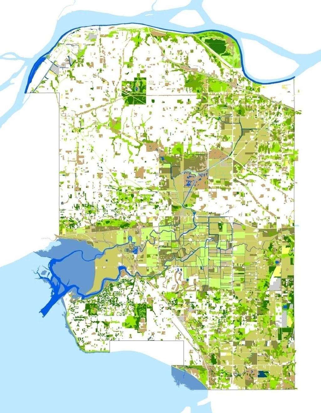
13 Why conserve ecosystem function? City of Surrey Sustainability charter 3. Air quality. Preserve clean air for current and future generations 4. The Built Environment. Establish a built environment that is balanced with the City s role as a good steward of the environment

14 What is a Green Infrastructure Network? A functioning network of ecosystems (forests, streams, fields, etc) is important.
15 Ecological Inventory Assess environmental conditions across Surrey s landscape land and water features, sensitive species, and vegetation

16 Land and Water Features Watersheds, slopes, aquifers Ministry of Environment data Ravine stability study City of Surrey reports + data

17 Sensitive species (known locations) Government databases City of Surrey Consultant reports Academic Studies
18 Vegetation Vegetation Classification System (USNVC)


19 Modifiers Vegetation Classification US National vegetation Classification System Aquatic Agricultural Developed Lake/pond River/fluvial Wetland Marine/intertidal Pasture Old field Forage Row crop Corral Bare ground Playing field Lawn Garden Golf Course Gravel/dirt road Road margin Urban trees


20 Naturalness mature Increasing ecological significance young
21 Summary of vegetation inventory 59% of Surrey mapped in vegetation inventory - Areas with significant natural features or vegetative cover - urban areas or suburban areas not mapped, except for parks, greenways and other significant features
22 Vegetation Inventory Results 18% Vegetation class 41% 5% 7% 1% 28% Forest Shrubland Herbaceous Sparse Vegetation Unvegetated Not mapped Naturalness of vegetation 41% 26% 10% Cultural Altered Semi-natural Mainly natural Natural Not mapped 1% 11% 11%
23 Green Infrastructure Network The network is comprised of important hubs, sites and linkages that sustain ecological processes.

24 Network Designation Larger and more natural areas form the hubs of the Network; sites are smaller but important natural areas; corridors connect hubs and sites. SITE Hub >10 ha Semi-natural or natural vegetation Site <10 ha Semi-natural Corridor Most natural route between hubs; ALR

25 Step 1. Identify Hubs and Sites Hubs and Sites were identified based on patch size and the naturalness of the vegetation they contained: Hubs - contiguous area of large size (>10 ha) and moderate or high naturalness Sites - smaller areas (<10 ha) and moderate or high naturalness

26 Shades of green Most altered Mainly natural Most natural Urban neighbourhoods Greenway connections Large forested parks
27 Interpret shades of green for landscape connectivity Slope Land Use (residential, urban, park, etc.) Vegetation inventory Roads Streams Interior forests Riparian forests Patchwork of naturalness; routes easiest for mobility of wildlife, genetic material and ecological process


28 Step 2. Identify Potential Corridors Species move between hubs based on the character (impedance) of the intervening landscape (forest, urban, etc) Ease of wildlife movement Easier Harder Vegetation + Land Use/ = Transportation Impedance


29 Hubs, Sites and Corridors Promote successful natural processes and a vibrant local ecology


30 Regional Connections Connections to areas outside of Surrey: Langley, Delta, and Whatcom County. Understanding the regional context is critical for effective conservation

31 Aquatic Habitat Greenways Connection Example Stream corridor

32 Upland Habitat Greenways Connection Example Upland corridor
33 Implementation? Variety of tools and techniques Private land Public Acquisition Ecological gift (tax benefit) Land trust Park dedication during subdivision Transfer of development potential Lot clustering/upzoning/density bonus Comprehensive development zones Covenant during subdivision Development Permit Tree Protection Bylaw Development Application process Site plan, site visit by staff QEP, review process, certified contractors Information and Education Voluntary stewardship Public land Land Management Policy Negotiations and discussions Parks planning and operations Landscape guidelines Contractor qualifications Both Specifics in Neighbourhood Plans and Zoning Policy in OCP

34 Upland Habitat Greenways Greenspace for multi-use trail and riparian forest conservation Steep slopes Transfer of development potential Park Dedication Riparian Areas Regulations


35 Upland Habitat Greenways Island and shoreline for passive recreation and conservation Transfer of development potential Park Dedication Shoreline Setback NGO Land Purchase

36 Crown Water water bodies body Land swap Restoration of ecological corridor Strategically locate Strategic location of supporting land supporting land uses uses Land Purchase Municipal Reserve Environmental Reserve Constructed Wetland Assembly an ecological network courtesy of the City of Edmonton
37 Upland Habitat Greenways Next steps Evaluate Ecological Significance Discuss environmental management areas (next meeting) Within the network of stewardship opportunities, there is a relationship between ecological features of the landscape and how the land is used, owned and managed. Different management options are available, depending on whether the land is held privately or publicly. The next workshop will explore how to define management areas and tools based on the type of Environmental feature and the form of ownership.
City of Surrey Ecosystem Management Study. Integration of ecological processes with land use
 City of Surrey Ecosystem Management Study Integration of ecological processes with land use Natural areas in Surrey are changing as the City grows and evolves. Many important natural areas remain or may
Surrey Ecosystem Management Study
 Surrey Ecosystem Management Study Green Infrastructure Network Opportunities Public Open House & Information Session June 24 th, 2010 EMS Process Ecological Inventory Ecological Assessment Management Policy
DEVELOPMENT PERMIT SENSITIVE ECOSYSTEMS
 DEVELOPMENT PERMIT SENSITIVE ECOSYSTEMS What is the Sensitive Ecosystem Development Permit Area (SEDPA)? Surrey s SEDPA is made up of two distinct classifications of the natural environment: Streamside
OPEN SPACE CHAPTER 7: OVERVIEW. Preserve open space to protect natural resources, enhance character and provide passive recreation opportunities
 CHAPTER 7: OPEN SPACE OVERVIEW Ridgefield has made tremendous progress permanently preserving areas of town as open space. Open space preservation can serve many important purposes, including: protect
Southwest Fleetwood Enclave
 Southwest Fleetwood Enclave Development Concept Plan Southwest Fleetwood Enclave 1 st Land Owners Meeting April 30 th, 2012 Presentation Overview Why the Plan? ; Overview & Purpose of Study; Constraints
10.0 Open Space and Public Realm
 10.0 Open Space and Public Realm 10.0 Open Space and Public Realm The Public Open Space System is comprised of: outdoor spaces available for public use that are either publicly owned (e.g., parks and
City of Langford Green Development Checklist
 City of Langford Green Development Checklist The following Green Development Checklist creates a sustainability standard for all comprehensive development within the City of Langford. The commitments made
RECREATION, OPEN SPACE AND GREENWAYS ELEMENT GOALS, OBJECTIVES, AND POLICIES
 RECREATION, OPEN SPACE AND GREENWAYS ELEMENT GOALS, OBJECTIVES, AND POLICIES GOAL R-1: DEVELOP A RECREATION, OPEN SPACE AND GREENWAYS SYSTEM AS AN INTEGRAL COMPONENT OF AN OVERALL, COUNTY-WIDE ECONOMIC
Riparian Buffer on the Bushkill Creek. Policies
 Riparian Buffer on the Bushkill Creek Riparian buffers provide numerous benefits to landowners and the community by protecting groundwater recharge areas, providing flood control, providing stormwater
1. Parks & Recreation Neighborhood Parks Community Parks Special Use Sites 2. Open Space 3. Trails
 Appendix A: Park Classifications The intent of parks and recreation classifications is to aid in making acquisition and design decisions for park sites, facilities and the organization of recreation space
RECREATION AND OPEN SPACE ELEMENT GOALS, OBJECTIVES, AND POLICIES
 RECREATION AND OPEN SPACE ELEMENT GOALS, OBJECTIVES, AND POLICIES Goal 7 To provide park facilities, recreation programs, and open space resources that are safe, adequate, and accessible to all City residents,
A Joined-up Regional Landscape: A Roadmap to connect the parts
 Breaking the Barriers: Engineering Solutions to Ecological Problems A Joined-up Regional Landscape: A Roadmap to connect the parts Associate Professor Darryl Low Choy Urban Research Program Outline Nature
Innovative Land Use Techniques
 Innovative Land Use Techniques A Handbook for Sustainable Development Eric Williams, Assistant Administrator, NHDES Carolyn Russell, Principal Planner, NHDES Cliff Sinnott, Executive Director, RPC Jill
Regional Context Statement
 Regional Context Statement REGIONAL CONTEXT STATEMENT 3. REGIONAL CONTEXT STATEMENT In 1995, the Provincial Government passed into law the Growth Strategies Act. The purpose of this provincial initiative
Phase I Ecological Network Report Terms of Reference
 Phase I Ecological Network Report Terms of Reference INTRODUCTION In 2007, the City of Edmonton created a new Natural Area Systems Policy (C-531) and a strategic plan, Natural Connections. Together, these
Community Conservation Workshop. Lake Placid
 Community Conservation Workshop Lake Placid 2 Community Conservation Program Welcome! We have designed a Community Conservation Program that listens to the needs of community members. We are conducting
Chapter 5: Natural Resources and Environment
 NATURAL RESOURCES AND ENVIRONMENT 5-1 5 Chapter 5: Natural Resources and Environment BACKGROUND AND INTENT Urban expansion represents the greatest risk for the future degradation of existing natural areas,
Figure 1. Proposed Strategic Habitat Conservation Areas for Florida
 Figure 1. Proposed Strategic Habitat Conservation Areas for Florida Critical Lands and Waters Identification Project (CLIP) Cooperative Effort Century Commission for Sustainable Florida Florida Natural
National Association of Conservation Districts. Kris Hoellen Vice President, Sustainable Programs The Conservation Fund September 19, 2013
 National Association of Conservation Districts Kris Hoellen Vice President, Sustainable Programs The Conservation Fund September 19, 2013 Our Mission The Conservation Fund forges partnerships to conserve
Community Conservation Workshop. Saranac River Basin Communities
 Community Conservation Workshop Saranac River Basin Communities 2 Community Conservation Program Welcome! We have designed a Community Conservation Program that listens to the needs of community members.
LANDSCAPE ARCHITECTURAL DESIGN: PROCESS, PREDILECTIONS, AND PRIORITIES
 LANDSCAPE ARCHITECTURAL DESIGN: PROCESS, PREDILECTIONS, AND PRIORITIES ECOLOGICAL DESIGN IN THE SOUTHEAST APRIL 23, 2014 DR. JON CALABRIA, ASLA ASSISTANT PROFESSOR, COLLEGE OF ENVIRONMENT AND DESIGN, UNIVERSITY
6Natural. Environment Development Permit Guidelines
 6Natural Bylaw 2600-2016, being "Official Community Plan Bylaw, 2016" Schedule "A" CITY OF ABBOTSFORD OFFICIAL COMMUNITY PLAN Environment Development Permit Guidelines Part V - 6-1 Area Subdivision or
Whitemarsh Township Greenway Plan
 Whitemarsh Township Greenway Plan Prepared for: Whitemarsh Township August 16, 2007 Table of Contents Table of Contents... i Introduction... 1 Study Area Setting... 2 Regional Setting... 2 Township Character...
Working Group Meeting
 April 4,, 2017 Parks Operations Bldg Working Group Meeting Arts Districts Overview Stormwater/RPA/Stream Considerations First Principles Agenda 7:00pm 7:05pm 7:10pm 7:40pm 8:30pm 9:40pm 9:45pm Welcome
Green Infrastructure. NYS Department of Environmental Conservation
 Green Infrastructure Green infrastructure is an interconnected network of natural areas and open spaces that sustains ecosystems. Benedict, M.A. and E.T. McMahon. 2006. Green Infrastructure Linking Landscapes
FUNDAMENTAL BUILDING BLOCKS
 FUNDAMENTAL BUILDING BLOCKS THE WEB OF GIBSONS - EXISTING Lacks Community Structure and Support Circulation, surface water flow and buildings are disjointed from the community Social neighbourhoods are
CITY OF LANGLEY OFFICIAL COMMUNITY PLAN BYLAW, 2005, NO APPENDIX II - REGIONAL CONTEXT MAP
 CITY OF LANGLEY OFFICIAL COMMUNITY PLAN BYLAW, 2005, NO. 2600 APPENDIX II - REGIONAL CONTEXT MAP ± Legend Agricultural Mixed Employment Industrial Conservation & Recreation Regional City Centre Urban Containment
What is the EDPA? The EDPA has three objectives: 1. Protect biodiversity. 2. Mitigate damage during development. 3. Restore degraded ecosystems
 What is the EDPA? Environmental Development Permit Areas are the best tool available to municipalities to protect ecosystems and habitat on private land. The EDPA has three objectives: 1. Protect biodiversity
KAMPLAN City of Kamloops. Section D. Land Use Policies D-1
 KAMPLAN City of Kamloops Section D Land Use Policies D-1 City of Kamloops KAMPLAN D 1 Land Management and Development This section links to the following Community Values: D-2 develop complete neighbourhoods
This page intentionally blank.
 This page intentionally blank. Parks, Recreation, and Open Space Chapter Relationship to Vision Vision Parks, Recreation and Open Space Chapter Concepts County Government. County government that is accountable
Green Infrastructure Policies and Ordinances
 Green Infrastructure Policies and Ordinances October 23, 2013 By Karen Firehock, Green Infrastructure Center 2013 Georgia Urban Forest Council s 23 rd Annual Conference The mission of the nonprofit Green
Natural Heritage areas are characterized by one or more of the following values:
 SECTION 6: LAND USE POLICIES - NATURAL HERITAGE The Natural Heritage policies reference features and areas that provide ecological functions critical to the survival of all species - including humans.
Planning a Development in the District of Summerland
 Planning a Development in the District of Summerland A Special Place Summerland enjoys beautiful lake views and abundant natural areas. As our valley s population grows, we want to maintain these natural
Florida Forever Conservation Needs Assessment Overview Maps
 Florida Forever Conservation Needs Assessment Overview Maps Prepared by Florida Natural Areas Inventory, The maps in this document are derived from the Florida Forever Conservation Needs Assessment, an
Objectives and Strategies for the Integration of Recreation, Parks and Open Space in Regional Plans
 BULLETIN 2 Objectives and Strategies for the Integration of Recreation, Parks and Open Space in Regional Plans TABLE OF CONTENTS Introduction 3 Land-use Framework Outcomes 1 4-8 Land-use Framework Outcomes
Parks, Open Space and Trails
 Introduction Parks have often been referred as the lungs of our cities, cleansing the air of pollutants and particulate matter. Parks are also gathering places for families and community. They offer spaces
Minnesota Department of Natural Resource - Natural Resource Guidance Checklist Conserving Natural Resources through Density Bonuses
 Minnesota Department of Natural Resource - Natural Resource Guidance Checklist Conserving Natural Resources through Density Bonuses NRDB Why Use Density Bonuses & This Checklist Local units of government
Woodland Conservation and the Master Plan
 1 WHAT IS A MASTER PLAN? A Vision for the Future of Your Community Woodland Conservation and the Master Plan Goals Objectives Strategies 2 How Will Your Community Look? TREE PRESERVATION AND THE MASTER
TOWN OF SPRINGFIELD, NEW HAMPSHIRE
 TOWN OF SPRINGFIELD, NEW HAMPSHIRE NATURAL RESOURCES INVENTORY EXECUTIVE SUMMARY March 2008 Prepared by: Watershed to Wildlife, Inc. Natural Resource Consultants 42 Mill Street, Suite 3 Littleton, NH 03561
Town of Peru Comprehensive Plan Executive Summary
 Town of Peru Comprehensive Plan Executive Communities that plan grow by choice, not by chance. A plan makes growth thoughtful, understandable, and predictable. A plan shows that a community is managing
One County s Success in Linking Watershed Protection and Land Use Planning
 One County s Success in Linking Watershed Protection and Land Use Planning Bob Thompson Porter County Plan Commission March 28, 2012 Indiana Watershed Leadership Academy Population 160,000 Approximately
IV. Development in the Rural Overlay District
 Intracoastal Waterway Route 17 Route 168 Great Dismal Swamp VIRGINIA NORTH CAROLINA IV. Development in the Rural Overlay District IV-1 Route 17 in Chesapeake s Rural Overlay District affords distant views
Green Infrastructure. by Karen Engel, NYS DEC. NYS Department of Environmental Conservation
 Green Infrastructure by Karen Engel, NYS DEC What is Green Infrastructure? For some it s all about water Green Infrastructure techniques use soils and vegetation to infiltrate, evapotranspirate, and/or
Planning for Staten. Habitat Restoration and Green Infrastructure. Island s North Shore
 Habitat Restoration and Green Infrastructure Planning for Staten Island s North Shore Community Board 1 March 1, 2018 NYC Parks Forestry, Horticulture, and Natural Resources Funded by the NYS Department
Chapter 1. Community Context. Vision Statement Population and Housing Trends Legislative Context Regional Context Statement
 Chapter 1 Community Context Vision Statement Population and Housing Trends Legislative Context Regional Context Statement 1.1 VISION STATEMENT CORPORATE MISSION STATEMENT To promote a safe and livable
Central Lake Ontario Conservation Conservation Lands Master Plan
 Conservation Lands Master Plan Top 13 Frequently Asked Questions 1. What are conservation lands? Where are these conservation lands located in the Central Lake Ontario Conservation watershed? Conservation
Executive Summary Purpose of the Plan Defining Open Space and Greenways
 Executive Summary Bucks County possesses a vast array of open space resources including natural areas, parks, farmland and historic and cultural resources that contribute to a high quality of life valued
Planning for and Managing Open Space and Natural Areas
 Planning for and Managing Open Space and Natural Areas Increasingly, development proposals in Delaware include large amounts of open space and natural areas. While open space is important as a community
Pinellas County Greenways
 Pinellas County Greenways USING GREENWAYS TO LINK OPEN SPACES The Florida Greenways Commission has defined a greenway as...a corridor of protected open space that is managed for conservation and/or recreation.
Cherry Beach Shoreline Protection Infrastructure Conceptual Design and Class EA
 Welcome Cherry Beach Shoreline Protection Infrastructure Conceptual Design and Class EA May 3, 2012 Study Area Cherry Beach neighbourhood is located in lower Stoney Creek on Lake Ontario, east of Millen
Preface. Erie. Scranton. Allentown. Pittsburgh. Harrisburg. Philadelphia
 The Southern Alleghenies Region The Southern Alleghenies Region spans the Laurel Highlands and Allegheny Front in the west across the Appalachians to the east. It is comprised of Blair, Bedford, Cambria,
THREE-STEP DESIGN PROCESS FOR OPEN SPACE SUBDIVISIONS
 00216106.DOC NMA/RRK 1/30/14 THREE-STEP DESIGN PROCESS FOR OPEN SPACE SUBDIVISIONS Open space subdivisions, sometimes called cluster developments, maintain a significant portion of a development site in
Simon Fraser University Official Community Plan
 Simon Fraser University Official Community Plan 1.0 Introduction Adopted 1996 September 9, Amended April 15, 2002 1.1 The Role of the S.F.U. Official Community Plan 1.1.1 The Simon Fraser University Official
DRAFT Open Space Technical Bulletin
 DRAFT Open Space Technical Bulletin This guidance is intended to clarify how the Open Space Goal and Objectives of the Regional Policy Plan (RPP) are to be applied and interpreted in Cape Cod Commission
Toronto Complete Streets Guidelines
 Toronto Complete Streets Guidelines 108 110 7.1 Green Infrastructure Design Principles 112 7.2 Context-Sensitive Green Streets 114 7.3 Key Green Street Elements Green infrastructure refers to natural and
Strategic Plan August 2017
 Strategic Plan August 017 BREATHE EDMONTON S GREEN NETWORK STRATEGY FOUNDATIONS 1 1.1 The Need for a Green Network Strategy... 1. Purpose of the Strategy...3 1.3 Structure of the Document...3 1.4 Planning
Ecological Network Management Strategy. August 2015
 Richmond s Ecological Network Management Strategy i Richmond s Ecological Network Management Strategy August 2015 Richmond s Ecological Network Management Strategy ii Acknowledgements This document was
Los Angeles River-Arroyo Seco Confluence Restoration Vision Plan. Professor Meredith McKenzie, JD Urban & Regional Planning Dept Cal Poly Pomona
 Los Angeles River-Arroyo Seco Confluence Restoration Vision Plan Professor Meredith McKenzie, JD Urban & Regional Planning Dept Cal Poly Pomona The Los Angeles River Watershed Arroyo Seco Watershed Map
FARMING PROTECTION. The Farming Protection Development Permit Guidelines are organized into five main categories:
 Development Permits Farming Protection DP4 DEVELOPMENT PERMIT GUIDELINES: FARMING PROTECTION The Farming Protection Development Permit Guidelines are organized into five main categories: General Single
Staff will be providing an overview of the project need, purpose and intent for consideration as part of the Amendment cycle.
 Agenda Item D-2 City of Tacoma Planning and Development Services To: Planning Commission From: Stephen Atkinson, Planning Services Division Subject: Open Space Corridors Project Meeting Date: March 1,
TOWN OF BETHLEHEM OPEN SPACE CONSERVATION PLAN PUBLIC MEETING: OCTOBER 12, 2017
 TOWN OF BETHLEHEM OPEN SPACE CONSERVATION PLAN PUBLIC MEETING: OCTOBER 12, 2017 Welcome and Agenda 6:00 6:45: Open House, Part One 6:45 7:15: Presentation and Questions 7:15 8:00: Open House, Part Two
A. Selma Park, Davis Bay and Wilson Creek
 A. Selma Park, Davis Bay and Wilson Creek This waterfront neighbourhood consists of three separate community areas, linked by Highway 101, but with different character, land use patterns and future potential.
General Manager of Planning, Urban Design and Sustainability
 ADMINISTRATIVE REPORT Report Date: May 2, 2017 Contact: Katherine Isaac Contact No.: 604.873.7167 RTS No.: 10847 VanRIMS No.: 08-2000-20 Meeting Date: May 16, 2017 TO: FROM: SUBJECT: Vancouver City Council
Community Design Guidelines. Port Wallace DRAFT
 Community Design Guidelines Port Wallace DRAFT Energy 1 2 3 Nature Movement Connections Built Form DRAFT Layout Energy 1 Nature Community Design Guidelines GREAT COMMUNITIES PROTECT, CELEBRATE, AND CONSERVE
Principles for Ecological Landscape Design in Brownfield Business Parks
 Principles for Ecological Landscape Design in Brownfield Business Parks Part of USDA Forest Service research project # 00-JV-11231300-033: Aligning Social and Ecological Drivers of Urban Landscape Change
Chapter IV: Development Pattern
 Chapter IV: Development Pattern Introduction The 2002 Prince George s County Approved General Plan designates three growth policy tiers Developed, Developing, and Rural as well as three center designations
The City shall enhance and improve the accessibility of parks and recreational facilities while protecting their quality. by:
 GOALS, OBJECTIVES AND POLICIES GOAL 1: To provide open space and recreation as an essential element needed for the betterment of the City s character and quality of urban life. The City shall plan for
Blue/Green Infrastructure Study Accomack County, VA
 Blue/Green Infrastructure Study Accomack County, VA Draft Asset Maps March 8-9, 2010 Green Infrastructure Center, Inc. 2 Overview What is Green and Blue Infrastructure Project Timeline & Tasks Literature
Exhibit A. 8:9 Scuffletown Rural Conservation District
 Exhibit A 8:9 Scuffletown Rural Conservation District 8:9.1 Intent and Purpose The Scuffletown Rural Conservation (SRC) District is intended to provide for residential development that supports the development
Parks, Recreation, and Open Space Land Use Goals
 Parks, Recreation, and Open Space Land Use Goals Issue: The preservation of open space and natural features will enhance the character of the built environment, promote public health and safety, provide
TABLE OF CONTENTS 1.0 INTRODUCTION GENERAL OBJECTIVES LAND USE DESIGNATIONS, OBJECTIVES AND POLICIES 4
 Schedule I- Redstone Golf Course Resort Area Sector Plan 1 TABLE OF CONTENTS 1.0 INTRODUCTION 3 2.0 GENERAL OBJECTIVES 3 3.0 LAND USE DESIGNATIONS, OBJECTIVES AND POLICIES 4 4.0 TRANSPORTATION AND ROAD
Green Infrastructure
 Statutory Authorization: 24 V.S.A. 4402, 4410, 4414, 4416-4418, 4424 Type: NONREGULATORY & REGULATORY Related Topic Areas: Land Use & Development Regulations; Open Space & Resource Protection Programs
Sustainable Sites. hblanarc.ca. RDN Workshop June 25, David Reid, FCSLA, Landscape Architect, Environmental Designer
 Sustainable Sites RDN Workshop June 25, 2011 David Reid, FCSLA, Landscape Architect, Environmental Designer hblanarc.ca Surrey ESA Networks & linear corridors ESA Network: Develop with Care SITE Hub >10
4 Sustainability and Growth Management
 4 Sustainability and Growth Management Introduction Traditionally, has assumed growth and development with limited consideration for the long-term negative social, environmental or economic impacts on
E X I S T I N G F A C I L I T I E S
 E X I S T I N G F A C I L I T I E S An extensive network of park, recreation and open space facilities is provided by the City and other agencies including County, School District, Port and State and is
Landscaping and Biodiversity: Conserving Biodiversity in Urban Planning and Development
 Landscaping and Biodiversity: Conserving Biodiversity in Urban Planning and Development Audio Options TO USE YOUR COMPUTER'S AUDIO: When the Webinar begins, you will be connected to audio using your computer's
PARKS AND RECREATION
 PARKS AND RECREATION WHAT YOU WILL FIND IN THIS CHAPTER: Background information on the development of the Park, Recreation, and System Plan (PRSP). General overview of Ellensburg s parks and recreation
Tackling Difficult SEQR Topics
 Presented by Nan Stolzenburg AICP CEP and Don Meltz AICP Tackling Difficult SEQR Topics COMMUNITY CHARACTER, HISTORIC/ARCHAEOLOGICAL RESOURCES & HABITATS/ENDANGERED SPECIES Training Agenda Introductions
OFFICIAL COMMUNITY PLAN. Bylaw 1750, 2014
 OFFICIAL COMMUNITY PLAN Bylaw 1750, 2014 AS ADOPTED ON JUNE 24, 2014 CITY OF ARMSTRONG BYLAW 1750, 2014 A BYLAW TO ADOPT AN OFFICAL COMMUNITY PLAN WHEREAS the Local Government Act authorizes Council to
TERRESTRIAL NATURAL HERITAGE SYSTEM STRATEGY APPENDIX F: MODEL POLICIES FOR THE IMPLEMENTATION OF THE TARGET TERRESTRIAL NATURAL HERITAGE SYSTEM
 TERRESTRIAL NATURAL HERITAGE SYSTEM STRATEGY APPENDIX F: MODEL POLICIES FOR THE IMPLEMENTATION OF THE TARGET TERRESTRIAL NATURAL HERITAGE SYSTEM C H A P T E R 1 M O D E L P O L I C I E S F O R I M P L
Phase II Ecological Network Report Terms of Reference. Terms of Reference
 Phase II Ecological Network Report Terms of Reference Phase II Ecological Network Report Terms of Reference APRIL 2014 April 2014 Phase II Ecological Network Report Terms of Reference contents 1.0 Introduction.................................................................
AMENDMENT NO. 30 TO THE OFFICIAL PLAN OF THE TOWN OF MILTON
 AMENDMENT NO. 30 TO THE OFFICIAL PLAN OF THE TOWN OF MILTON Subject: Boyne Survey Secondary Plan and Related Official Plan Amendments The following text and schedules constitute Amendment No. 30 to the
Existing Facilities. Chapter 3:
 Leave all the afternoon for exercise and recreation, which are as necessary as reading, I will rather say more necessary because health is worth more than learning. - Thomas Jefferson Chapter 3: Existing
CROWN POINT SUBDIVISION
 CROWN POINT SUBDIVISION A COMPARISON OF CONVENTIONAL VERSUS CONSERVATION SUBDIVISION DESIGN DEVELOPER: PAUL LUCIANO BUILDERS LAND PLANNING & DESIGN: DAVID LAIRD ASSOCIATES FUNDING PROVIDED BY: PA SEA GRANT
TO BE COMPLETED BY APPLICANT
 Planning Division #200-2564 Shaughnessy Street Port Coquitlam BC V3C 3G4 Tel 604.927.5442 Fax 604.927.5404 Email planning@portcoquitlam.ca Application for Watercourse Development Permit Watercourse Development
4. What are the goals of the Kawarthas, Naturally Connected project? 7. What are watersheds and why are they being used as the project boundaries?
 Frequently Asked Questions (FAQs) 1. What are Natural Heritage Systems (NHS)? 2. Why are they important? 3. Which areas of the province have undertaken NHS projects? 4. What are the goals of the Kawarthas,
RECOMMENDED DIRECTIONS REPORT FOR THE TOWN OF RICHMOND HILL
 RECOMMENDED DIRECTIONS REPORT ENVIRONMENTAL POLICY REVIEW FOR THE TOWN OF RICHMOND HILL Prepared for: Town of Richmond Hill 225 East Beaver Creek Road Richmond Hill, ON, L4B 3P4 Prepared by: SENES Consultants
Conservation Development
 Acknowledgements RIDEM: Scott Millar Anthony Lachowicz-Planning and Zoning Consultant Director of Planning 1 : a creative land use technique that allows a community to guide growth to the most appropriate
STREAM BUFFERS
 88-415 STREAM BUFFERS 88-415-01 PURPOSE In the Kansas City region and throughout the nation, vegetated stream buffers have been clearly shown to protect stream stability and related infrastructure, improve
Chapter 13: Implementation Plan
 Implementation A. Introduction The Implementation Plan, in table form on the following pages, provides a summary of all the Action Items recommended in Chapters 2 through 12. The table also indicates which
NORTH DISTRICT. Description
 VI plan and major recommendations district plans north disrict NORTH DISTRICT Description The North District comprises approximately 105 acres and is bounded by two important bio-habitats and corridors
Baselands Trails Master Plan Public Meeting. April 28, 2015 Fire Academy, 895 Eastern Avenue, Toronto 6:30 p.m. to 9:00 p.m.
 Baselands Trails Master Plan Public Meeting April 28, 2015 Fire Academy, 895 Eastern Avenue, Toronto 6:30 p.m. to 9:00 p.m. Baselands Trails Master Plan Meeting Purpose To present and get feedback on:
Clair-Maltby Community visioning
 Clair-Maltby Community visioning workshop #1 Summary April 27th, 2017 Table of Contents INTRODUCTIon 1 PURPOSE 1 CONSULTATION STRUCTURE 2 PARTICIPANT FEEDBACK 3 VISIONING EXERCISE 8 ONLINE SURVEY RESULTS
Overview Environmentally Sensitive Areas (ESA) Management Strategy
 Management Strategy") September 17, 2012 Overview 2012 Environmentally Sensitive Areas (ESA) Management Strategy Prepared by the Policy Planning, City of Richmond September 17, 2012-2 - Origin Overview In October 2009, Council
September 17, 2012 Overview 2012 Environmentally Sensitive Areas (ESA) Management Strategy Prepared by the Policy Planning, City of Richmond September 17, 2012-2 - Origin Overview In October 2009, Council
KISHWAUKEE MUNICIPALITIES PLAN FOR SUSTAINABLE DEVELOPMENT
 KISHWAUKEE MUNICIPALITIES PLAN FOR SUSTAINABLE DEVELOPMENT 4 "Natural areas, parks and open space create a high quality of life that attracts tax-paying businesses and residents to communities." Trust
Greenspace Master Plan
 Greenspace Master Plan Strategies for Ottawa's Urban Greenspaces August 2006 ottawa.ca Greenspace Master Plan Strategies for Ottawa s Urban Greenspaces Publication: 4-01 City of Ottawa, 2006 Aussi disponible
CHAPTER 4 FUTURE LAND USE AND URBAN SERVICES DISTRICTS
 CHAPTER 4 FUTURE LAND USE AND URBAN SERVICES DISTRICTS Introduction This chapter discusses how Benzie County should grow and change in the future. A community can grow and change in many different ways.
Westmoreland County Greenways Plan
 Westmoreland County Greenways Plan Citizens Advisory Board Review Draft April 2007 Prepared for: Westmoreland County and Smart Growth Partnership of Westmoreland County Prepared by: Environmental Planning
IMPLEMENTATION STRATEGY: GOAL 1: TO SUSTAIN A HEALTHY NATIVE PRAIRIE GRAZING RESOURCE
 IMPLEMENTATION STRATEGY: GOAL 1: TO SUSTAIN A HEALTHY NATIVE PRAIRIE GRAZING RESOURCE Objectives Actions Timetable Lead and Supporting Agencies 1. Maintain or adopt sound rangeland practices that are reflective
FINDING WAYS TO CONNECT
 FINDING WAYS TO CONNECT Linking habitat together to function as an ecological whole The Green Leap: A Primer for Conserving Biodiversity in Subdivision Development. Mark E. Hostetler. University of California