Green Planning in Albemarle and Charlottesville
|
|
|
- Bruno Cooper
- 5 years ago
- Views:
Transcription


1 Green Planning in Albemarle and Charlottesville Presentation to League of Women Voters February 10, 2019 By Karen Firehock, Executive Director Green Infrastructure Center 2019

2 The Green Infrastructure Center helps communities evaluate their green assets to maximize ecological, economic and cultural returns. We do this by: Building landscape models Teaching courses and workshops Research into new methodologies Helping communities create strategies We re located here in your region!

3 Slide Show Topics Planning and Zoning 101 Planning for our Green Infrastructure Benefits of GI Planning Examples: Albemarle Charlottesville
4 Virginia s Comprehensive Planning Comp Plans reviewed at least once every 5 years. careful and comprehensive surveys and studies of the existing conditions and trends of growth, and of the probable future requirements of its territory and inhabitants. guiding and accomplishing a coordinated, adjusted and harmonious development which will, in accordance with present and probable future needs and resources, promote the health, safety, morals, order, convenience, prosperity and general welfare of the inhabitants Zoning must be in accordance with comprehensive plans so comp plans should include maps of key natural assets.


5 Land use controls: zoning States have broad residual power to legislate for the health, safety, morals and general welfare of their citizens. Also called the police powers and provides the authority for zoning. States usually delegate these police powers to localities, but state law still takes precedence over local laws. As part of these police powers we have the ability to prevent nuisance. Zoning can use the police powers to prevent nuisance. Zoning: residential, commercial, rural, PUDs
6 Rezoning: Change Rights Rezoning sought by landowner to enable them to do something different must choose an existing zoning class (e.g. change R1 to R3). Re-zonings must be in accordance with the comprehensive plan. Do our comprehensive plans include key natural assets and areas to conserve?


7 Albemarle Zoning Most of the County (white) is Rural Area. Growth is limited to urban ring around Charlottesville, Crozet and 29 North. RA zoning requires larger lots purpose to encourage rural uses and discourage sprawl. See ALBEMARLE COUNTY CODE , Zoning Supp. #105, CHAPTER 18. ZONING SECTION 10. RURAL AREAS DISTRICT

8 Charlottesville Zoning Charlottesville seeks to encourage denser development. It has tried to protect neighborhoods, historic districts etc. while promoting vibrant commercial areas, multi-modal transportation and a healthful environment. The city is currently adopting a new comprehensive plan to lay the table for how it plans to continue to develop/redevelop. ents-and-services/departments-hz/neighborhood-developmentservices/comprehensive-plan
 adds a green infrastructure data layer (trees and other vegetation).")
9 As we grow/redevelop, we should consider our green infrastructure A map of a city (left) shows a neighborhood s gray infrastructure including buildings and roads. Classified high-resolution satellite imagery (right) adds a green infrastructure data layer (trees and other vegetation).

10 Benefits of Conserving Green Infrastructure Preserving biodiversity and wildlife habitat. Conserving working lands such as farms and forests, that contribute to the economy. Protecting and preserving water quality and supply. Providing cost-effective stormwater management and hazard mitigation. Improving public health, quality of life and recreation networks.
11 Green Infrastructure Planning Applications Zoning Tools and Comp Plans Park and open space planning I.d. lands for PDR or TDR programs New ordinance development Species protection Heritage tourism and viewsheds Ag and Forestall Districts Easements Transportation plans: roads/trails Land management Public Regulatory Private Voluntary


12 Green Infrastructure Planning Requires Thinking About How to Connect the Landscape It s about connecting the landscape! Not just key habitat patches but how we connect them! The more connected the landscape, the more resilient it is!
13 We need to protect habitat cores to conserve interior habitats. Take the average tree height 100 feet and multiply by 3 to get edge. Subtract that to learn what remains and whether there is enough area to constitute a core. If smaller, it may still be a key patch or site. Interior = Total Area 3(h)


14 Who Prefers Interior Forest Cores? Birds, e.g. cerulean warbler, Scarlet tanager Mammals, e.g. black bear, bobcat, n. flying squirrel Amphibians, e.g. spotted salamander

15 Corridors Connect Cores The ideal is 100 meters of safe space in the middle and 100 meters of edge. minimum width = 300 meters wide


")


16 Who Can Use the Corridors? (300 meters is ideal )


17 If cores or patches are too far apart, or if a core is lost, species may become isolated and decline over time. However, sometimes when cores are lost, species may decline
 Map Your Community s Ecological and Cultural Assets Based on the goals established in Step One and data from Step Two.")
18 Six Steps for Green Infrastructure Planning 1) Set Your Goals: What does your community/organization value? 2) Review Data What do we know or need to know, to map identified values? 3) Map Your Community s Ecological and Cultural Assets Based on the goals established in Step One and data from Step Two. 4) Risk Assessment What assets are most at risk and what could be lost if no action is taken? 5) Rank Your Assets and Determine Opportunities Based on those assets and risks you have identified, which ones should be restored or improved? 6) Implement Opportunities Include natural asset maps in both daily and longrange planning (park planning, comp plans, zoning, tourism and economic development, seeking easements etc)


19 Case Examples: Connecting and conserving intact landscapes to conserve biodiversity, clean water and livability. GIC has conducted more than 20 projects in VA. Today we will show Albemarle County and City of Charlottesville which received technical assistance from GIC for green infrastructure planning. Funded by a grant from the USDA Forest Service and the Virginia Department of Forestry. Albemarle and Charlottesville matched the grant with in-kind (staff and volunteer hours).


20 Albemarle Model: improves on the state model by creating a finer grained picture using 1 meter resolution rather than 30 meters. At 726 square miles, the county is one of the largest in Virginia. We can t survey every inch of the county we can model the habitat that is most likely to support native species.

21 A landscape from above (complexity!)

22 Land Cover

23 Where is the interior habitat? Identify Distinct Habitat Cores, and Supporting Fragments

24 Countywide Summary 179 areas meet the criteria for core habitat (> 100 contiguous acres of interior forest) This area accounts for 44% of forested land in the county Habitat Fragment = acres Small = acres Medium = 1,000 10,000 acres Large = 10,000 acres or larger

25 What s protected? Dark green = Park Pink = Conservation easement Orange = Open space use agreement parcels Light blue = Water protection ordinance buffers


26 Cores Will Need to Be Updated


27 Results help to place site-scale surveys in context Biodiversity Work Group Important Sites in Orange

28 Which Cores are Most Important for Connectivity?
29 Habitat maps can be used to inform comprehensive plans, transportation plans, economic development plans and more. Strategy 4g: Provide information to potential land subdividers on the importance of protecting habitat when creating lots for development.


30 Collection of Naturebased Recreation Data Popular running routes were created by GIC to better represent recreation assets in the county

31 Wineries, Cideries, and Breweries Can be landscape dependent as people visit them for beverages and views! Part of the rural area economy

32 Comp Planning Habitat maps can be used to inform comprehensive plans, transportation plans, industrial development plans and more. Albemarle County VA is using the maps to inform future growth and development.
33 Relation to Comprehensive Plan: Albemarle s ecosystems and natural resources will be thoughtfully protected and managed in both the Rural and Development Areas to safeguard the quality of life of present and future generations. Strategy 4a: Develop an Action Plan for Biodiversity to protect significant areas of biological importance in the County. Strategy 4b: Regularly repeat the land use/land-cover datagathering process (as begun in 2009) for the purpose of monitoring landscape changes

34 Strategy 4a and 4b have now been achieved! Data and maps have been created to inform the new Biodiversity Action Plan and will inform future updates to the comprehensive plan. Maps can be used for daily planning in working with landowners and developers to conserve as much intact and connected high value landscape as possible.

")
35 CP Obj. 4: Protect the biological diversity and ecological integrity of the County in both the Rural Area and Development Areas. Locally endangered examples: James spiny mussel (Pleurobema collina) Northern Long eared bat (Myotis septentrionalis) Protect RTE + preventing listings!

36 Protecting Water Supply Forests also protect surface water sources and aquifer recharge zones and reduce the cost of drinking water treatment. American Water Works Association found a 10% increase in forest cover reduced treatment costs for drinking water by 20%. (Ernst et al. 2004) Intact Forests Protect Water Supply and = cheaper water treatment Totier Creek Reservoir, Albemarle CP Objective 1: Ensure clean and abundant water resources for public health, business, healthy ecosystems, and personal enjoyment by preventing shortages and contamination.

37 Drinking Water How does the landscape support water quality and drinking water sources?

38 Protecting Air Quality CP Obj 2: Protect air quality. Forests remove volatile organic compounds, particulate matter and sequester carbon trees are the lungs of Albemarle County. Even at the neighborhood scale, trees significantly improve air quality. Well treed landscapes = healthier communities.

39 Green Assets = Real Estate $$$ $ Having a park within 1,500 feet of a home increased its sale price between $845 - $2,262 (in 2000 dollars). Economic Benefits of Recreation, Open Space, Recreation Facilities and Walkable Community Design, 2010 $ The larger the park, the more significant the property value increase. (ibid) Parks = better tax base = $! $ Large natural forest areas have a greater positive impact on nearby property prices than smaller urban parks or developed parks such as playgrounds, skate parks or golf courses. Bigger intact forests/natural areas = more $!

40 Job development Small companies, especially those that are have well paid and skilled workforce place a strong importance on the green of the local environment. Crompton Love and Moore, 1997 The creative class: artists, media, lawyers, analysts, make up 30 percent of the U.S. workforce and they place a premium on outdoor recreation and access to nature. Florida, 2002 Natural assets attract better paid jobs and thus a better tax base = $


41 The maps can help inform where future parks might be located based on population centers, need to protect key habitats or species, opportunities to increase recreation or site interpretation. Park and Open Space Planning

42 Heritage Tourism Heritage Tourists spend on average about 2.5 times more than all other types of tourists. They want to hike, see and touch history and they prefer to stay in close to where they visit. CP Economic Development Strategy 1c: Promote tourism that helps preserve scenic, historic, and natural resources.

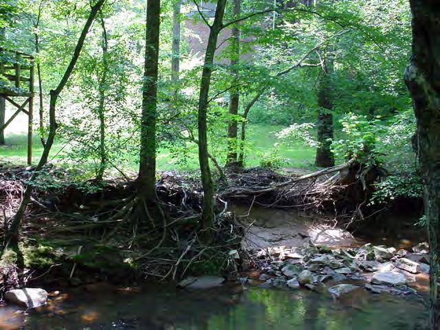
43 Viewshed Protection For tourism and heritage, identify views where visual character is important. GIS tools, such as spatial analyst can create a digital elevation model to understand what is visible from where. While voluntary, more analysis could be conducted. Monticello has worked with local developers to disguise rooftops and minimize building visibility.

44 Considerations for the Urban Ring Smaller scales still need open spaces In urban areas focus on: Trees and woodlots Habitat patches Streams and wetlands Trails and smaller parks Still can connect to larger networks Albemarle County s strategy is to protect the rural area and rural economy by encouraging growth in the urban ring and discouraging additional suburban developments in the rural area. And it s working!


45 Now how does this type of work apply to the City of Charlottesville? Aerial View

46 Aerial Gray Infrastructure Network

47 Aerial Gray Infrastructure Network Base Green Infrastructure Assets

48 Aerial Gray Infrastructure Network Base Green Infrastructure Assets Key Open Space/Protected Assets (nodes)
49 Aerial Gray Infrastructure Network Base Green Infrastructure Assets Key Open Space/Protected Assets (nodes) Trail Network
 Trail Network Large Supporting Tree Canopy")
50 Aerial Gray Infrastructure Network Base Green Infrastructure Assets Key Open Space/Protected Assets (nodes) Trail Network Large Supporting Tree Canopy Patches
51 Aerial Gray Infrastructure Network Base Green Infrastructure Assets Key Open Space/Protected Assets (nodes) Trail Network Large Supporting Tree Canopy Patches Creating Green Threads throughout City
52 Aerial Gray Infrastructure Network Base Green Infrastructure Assets Key Open Space/Protected Assets (nodes) Trail Network Large Supporting Tree Canopy Patches Creating Green Threads throughout City

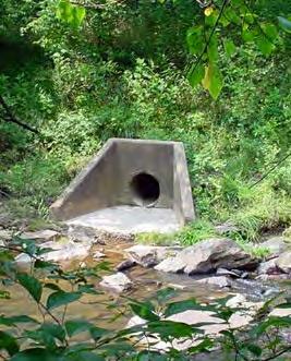
53 Water is also part of Green Infrastructure But we often neglect it We build in the floodplain -- parking lots along streams allow contaminants to reach surface waters and speed water flows.


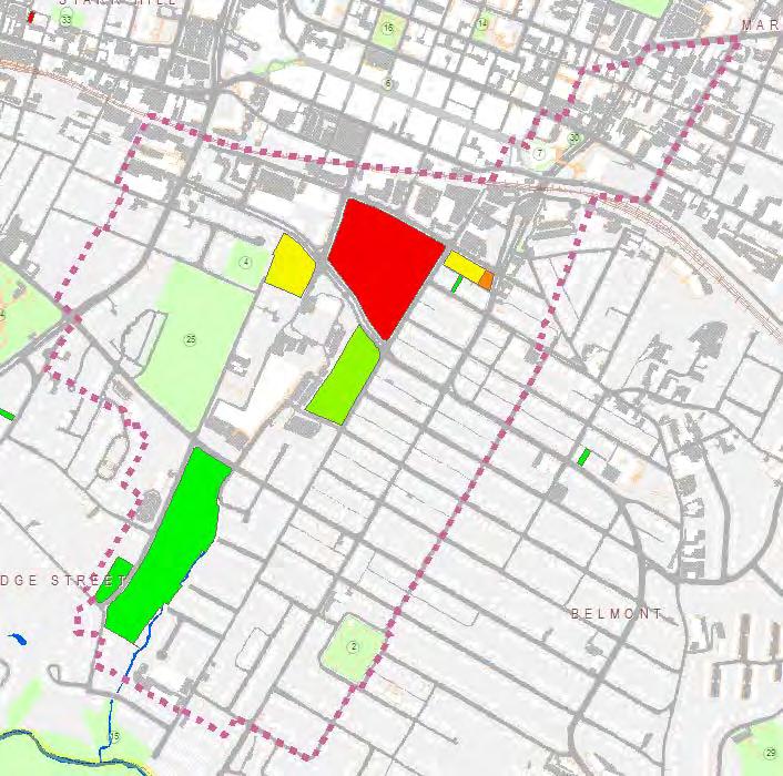
54 Stream buffers are important for green infrastructure networks Meadow Creek Moore s Creek Rivanna River
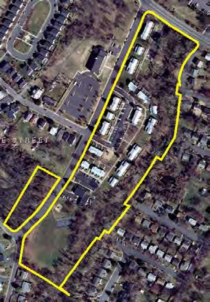
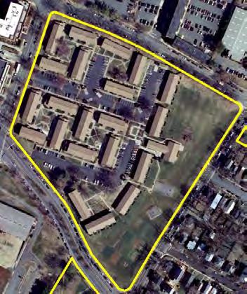
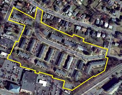
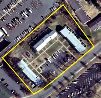
 52.")
55 Stream Buffers 71.7% tree canopy coverage in protected stream buffers (by code) All stream buffers have 71.4% coverage Ownership (all buffers) City owned: 24.7% On School Grounds: 1.7% On UVA Grounds: 7.1% Private/Other: 66.5% Protection (all buffers) 52.6% within protected stream buffer, on steep slopes, under conservation easement, or in a park


56 + Buffers can t solve lack of stormwater management =


57 Water flow strategies How do we make this function like this?


58 One acre of pavement releases 36 times more runoff than a forest. This parking lot could be retrofitted so we get less of this During a rainfall event of one inch, one acre of forest will release 750 gallons of runoff, while a parking lot will release 27,000 gallons (PennState Extension).


59 Most of the city s runoff is not treated as it pre-dates stormwater regulations. We can redesign streetscapes to slow and clean stormwater. Stormwater flow can be integrated into the streetscape in a way that provides multiple benefits traffic calming, pedestrian safety and landscaping. Water flow strategies

60 Yards are great sites for trees most of the city lands are residential so that is where we can have the greatest impact! Plant trees to protect and enhance buffer for waterways. Create multiple opportunities for water infiltration. Improvements to increase habitats for people, animals, fish.


61 Urban Impacts = Need for Mitigation Using Low Impact Development Green Rooftop Filterra Box Parking lot biofilter Rain Barrel Downspout filtration Porous pavers

62 Charlottesville interactive map City Green Interactive Web Page

63 Trees: the original and best green infrastructure! Trees give us cleaner air, shade, beauty and stormwater benefits at a cost that is far cheaper than engineered systems! Estimates for the amount of water a typical street tree can intercept in its crown, range from 760 gallons to 4000 gallons per tree per year, depending on species.
 Delays runoff up to 3.")
64 Urban Tree Canopy 20% of annual rainfall or > retained in crown (Xiao et al., 2000) Delays runoff up to 3.7 hours infiltration capacity of soils
65

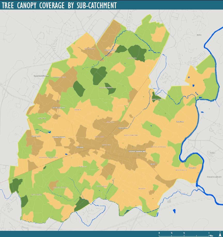
66 Tree Canopy Coverage of Neighborhoods and Their Streets (within 50ft of road centerlines) Barracks/Rugby Johnson Village Fry's Spring Greenbrier Locust Grove Lewis Mtn Venable Ridge Street Woolen Mills Fifeville Belmont Jefferson Park Avenue Martha Jefferson North Downtown Barracks Road The Meadows Rose Hill 10th & Page Starr Hill 0% 10% 20% 30% 40% 50% 60% 70% Total Canopy Coverage Canopy Coverage of Streets
67 Public/Assisted Housing What about social equity? Friendship Court 9.5% Tree Canopy South First Street 56% Tree Canopy Westhaven 25% Tree Canopy Michie Drive 21% Tree Canopy


68 Strategy: Plant more trees Fall Tree Sale, Image: Charlottesville Area Tree Stewards Slide Credit: UVA Green Lands Class, 2015


69 Estimating Tree Planting Feasibility Possible Planting Area
")
70 What would it take to reach certain canopy goals? (Using the Starr Hill neighborhood)


71 Even Green in infrastructure developed landscapes, plans connect we corridors can keep before habitat development connected and drainages intact, but only if we plan at a larger scale.

72 Charlottesville green CP Updates

73 In conclusion for the City Prioritize parcels for tree conservation meet with owners before site plans are finalized to find ways to save as many trees as possible and to plant new ones. For street trees, invest in tree planting wells that allow larger trees along with structural soils that allow larger tree support trees will pay us back in sales and property tax increases! Consider how to better engage private landowners since most city land is residential we have the greatest impact there! Plant your yard with native species, trees, raingardens!

74 In conclusion for the County Map the habitats and assets first plan for roads to avoid them and pathways to enjoy them. Adopt maps into policy documents and add to county GIS use them everyday! Identify the most important assets high quality ag soils, forests, views, water supply and recharge areas and ensure they are protected (buffer then, change zoning, add incentives, educate the public). Identify hazards and avoid building in those areas, let nature be your buffer (don t build in floodplains, avoid steep slops, cluster development and conserve open space). Adopt green policies and open space plans for the urban ring too it should be livable and desirable!

75 Let s Discuss Ideas! Green Infrastructure Center Inc. 440 Premier Circle, Suite 220 Charlottesville, VA, Firehock@gicinc.org
Green (and blue) Infrastructure Planning in VA
 Infrastructure Planning in VA") Green (and blue) Infrastructure Planning in VA Presentation to Rural Resiliency Forum By Karen Firehock Oct. 23, 2018 Green Infrastructure Center 2018 Slide Show Topics Definitions: Resilience Green Infrastructure
Green (and blue) Infrastructure Planning in VA Presentation to Rural Resiliency Forum By Karen Firehock Oct. 23, 2018 Green Infrastructure Center 2018 Slide Show Topics Definitions: Resilience Green Infrastructure
Green Infrastructure Policies and Ordinances
 Green Infrastructure Policies and Ordinances October 23, 2013 By Karen Firehock, Green Infrastructure Center 2013 Georgia Urban Forest Council s 23 rd Annual Conference The mission of the nonprofit Green
Conservation Corridor Planning and Green Infrastructure Themes
 Conservation Corridor Planning and Green Infrastructure Themes Prepared by the Green Infrastructure Center Inc. and the Northern Virginia Regional Commission February 22, 2011 Brief Overview Project Background
Mapping and Planning for Green Infrastructure
 Mapping and Planning for Green Infrastructure Karen Firehock, Executive Director TransportiCA Webinar Series August 30, 2018 Today 1. Green infrastructure defined 2. Mapping green infrastructure in rural
Using Green Infrastructure Planning To Support And Enhance Healthy Ecosystems and Communities
 Using Green Infrastructure Planning To Support And Enhance Healthy Ecosystems and Communities by Karen Firehock, Executive Director Green Infrastructure Center Inc. www.gicinc.org A Presentation to Master
Blue/Green Infrastructure Study Accomack County, VA
 Blue/Green Infrastructure Study Accomack County, VA Draft Asset Maps March 8-9, 2010 Green Infrastructure Center, Inc. 2 Overview What is Green and Blue Infrastructure Project Timeline & Tasks Literature
NEW GRANTS PROGRAM. Today I will describe what green infrastructure planning entails, how the model works and the importance of the work to planners!
 NEW GRANTS PROGRAM The South Carolina Forestry Commission received funds from the USDA Forest Service s Southern Region to build a green infrastructure landscape scale model and to fund several implementation
Green Infrastructure. by Karen Engel, NYS DEC. NYS Department of Environmental Conservation
 Green Infrastructure by Karen Engel, NYS DEC What is Green Infrastructure? For some it s all about water Green Infrastructure techniques use soils and vegetation to infiltrate, evapotranspirate, and/or
Town of Peru Comprehensive Plan Executive Summary
 Town of Peru Comprehensive Plan Executive Communities that plan grow by choice, not by chance. A plan makes growth thoughtful, understandable, and predictable. A plan shows that a community is managing
Conservation Corridor Base and Thematic Maps
 Conservation Corridor Base and Thematic Maps August 20, 2010 This project is funded in part by the Virginia Coastal Zone Management Program at the Department of Environmental Quality through Grant #NAO9NOS4190163
Living in Albemarle County s Urban Places
 Living in Albemarle County s Urban Places ALBEMARLE COUNTY, VIRGINIA A Closer Look at Albemarle s Approach to Managing Growth and Creating Quality Urban Environments www.albemarle.org Page 2 Living in
Planning Academy MARCH 8, 2015
 Planning Academy MARCH 8, 2015 Overview of Growth Management in Albemarle County Comprehensive Plans, Planning Initiatives Major Milestones Key Policies History Comprehensive Plan should precede Zoning
A BLUEPRINT FOR BROCKTON A CITY-WIDE COMPREHENSIVE PLAN
 A BLUEPRINT FOR BROCKTON A CITY-WIDE COMPREHENSIVE PLAN Public Meeting October 2016 1 Plan Summary and Discussion Public Meeting May 4 2017 City of Brockton Bill Carpenter, Mayor Department of Planning
Planning for and Managing Open Space and Natural Areas
 Planning for and Managing Open Space and Natural Areas Increasingly, development proposals in Delaware include large amounts of open space and natural areas. While open space is important as a community
This page intentionally blank.
 This page intentionally blank. Parks, Recreation, and Open Space Chapter Relationship to Vision Vision Parks, Recreation and Open Space Chapter Concepts County Government. County government that is accountable
Improve Neighborhood Design and Reduce Non Point Source Water Pollution
 HOW TO Planning Guide Improve Neighborhood Design and Reduce Non Point Source Water Pollution This document was funded by a grant from the New Hampshire Coastal Program with funding from the National Oceanic
Gloucester County s Comprehensive Plan. The Community Connection
 Gloucester County s Comprehensive Plan The Community Connection Current Comp Plan Adopted in 1991 with a 20 year planning horizon Updated in 1995 with Part V- Implementation Recommendations and Appendix
Draft Stillwater 2030 Comprehensive Plan- Goals and Policies
 Draft Stillwater 2030 Comprehensive Plan- Goals and Policies Instructions- Review each goal and policy and discuss with group any changes, deletions for additions to the list using your groups pen. Keep
Community Conservation Workshop. Lake Placid
 Community Conservation Workshop Lake Placid 2 Community Conservation Program Welcome! We have designed a Community Conservation Program that listens to the needs of community members. We are conducting
National Association of Conservation Districts. Kris Hoellen Vice President, Sustainable Programs The Conservation Fund September 19, 2013
 National Association of Conservation Districts Kris Hoellen Vice President, Sustainable Programs The Conservation Fund September 19, 2013 Our Mission The Conservation Fund forges partnerships to conserve
CHAPTER 4 FUTURE LAND USE AND URBAN SERVICES DISTRICTS
 CHAPTER 4 FUTURE LAND USE AND URBAN SERVICES DISTRICTS Introduction This chapter discusses how Benzie County should grow and change in the future. A community can grow and change in many different ways.
COMMUNITY DESIGN. GOAL: Create livable and attractive communities. Intent
 COMMUNITY DESIGN Intent An attractive, well-designed County will attract quality development, instill civic pride, improve the visual character of the community, and create a strong, positive image for
Countywide Green Infrastructure
 Montgomery County s Countywide Green Infrastructure F U N C T I O N A L M A S T E R P L A N The Maryland National Capital Park and Planning Commission INFRASTRUCTURE An underlying base or foundation especially
Source: Albemarle County Community Development 2010
 Source: Albemarle County Community Development 2010 GROWTH MANAGEMENT GOAL: Albemarle County s Development Areas will be attractive, vibrant areas for residents and businesses, supported by services, facilities,
Minnesota Department of Natural Resource - Natural Resource Guidance Checklist Conserving Natural Resources through Density Bonuses
 Minnesota Department of Natural Resource - Natural Resource Guidance Checklist Conserving Natural Resources through Density Bonuses NRDB Why Use Density Bonuses & This Checklist Local units of government
Open Space, Natural Areas, Parks, and Recreation
 Open Space, Natural Areas, Parks, and Recreation WHAT ARE THE CITY S CURRENT VALUES? This section addresses open spaces, natural areas, parks and recreation, and stormwater multi-use projects under separate
INTRODUCING THE BALTIMORE CITY GREEN NETWORK VISION PLAN
 INTRODUCING THE BALTIMORE CITY GREEN NETWORK VISION PLAN GOALS OF THE GREEN NETWORK PLAN Protect and enhance the unique ecological resources of our city Support economic growth and sustainable redevelopment
G. RECREATION AND OPEN SPACE ELEMENT. The following summarizes the Recreation and Open Space Element:
 G. RECREATION AND OPEN SPACE ELEMENT The purpose of the Element is to provide the framework and direction for a comprehensive system of public and private sites for recreation, including, but not limited
DISCUSSION TOPIC: ST JOHNS RIVER & ITS TRIBUTARIES (BPII) 2030 COMPREHENSIVE PLAN POLICES AND REGULATORY FRAMEWORK
 2030 COMPREHENSIVE PLAN POLICES AND REGULATORY FRAMEWORK") DISCUSSION TOPIC: ST JOHNS RIVER & ITS TRIBUTARIES (BPII) 2030 COMPREHENSIVE PLAN POLICES AND REGULATORY FRAMEWORK St. John s River & Its Tributaries Issue Summary: The St. Johns River is an important
DISCUSSION TOPIC: ST JOHNS RIVER & ITS TRIBUTARIES (BPII) 2030 COMPREHENSIVE PLAN POLICES AND REGULATORY FRAMEWORK St. John s River & Its Tributaries Issue Summary: The St. Johns River is an important
The following principles guide the development of goals and strategies to protect and promote these amenities:
 OPEN SPACE/PARKS/TRAILS/RECREATION GOALS/STRATEGIES Cherry Hills Village is a living environment that offers low density development, open areas, public scenic vistas, public trails and public parks. This
Community Conservation Workshop. Saranac River Basin Communities
 Community Conservation Workshop Saranac River Basin Communities 2 Community Conservation Program Welcome! We have designed a Community Conservation Program that listens to the needs of community members.
Rural Land Use Designations Kittitas County December 6, 2007 Draft
 KITTITAS COUNTY COMMUNITY DEVELOPMENT SERVICES 411 N. Ruby St., Suite 2, Ellensburg, WA 98926 CDS@CO.KITTITAS.WA.US Office (509) 962-7506 Fax (509) 962-7682 Rural Land Use Designations Kittitas County
Green Infrastructure. NYS Department of Environmental Conservation
 Green Infrastructure Green infrastructure is an interconnected network of natural areas and open spaces that sustains ecosystems. Benedict, M.A. and E.T. McMahon. 2006. Green Infrastructure Linking Landscapes
Greenways as an alternative to traditional infrastructure. Green Infrastructure
 Greenways as an alternative to traditional infrastructure Green Infrastructure What is a Greenway? Little (1990) - A linear open space along a natural or human made corridor. Fabos - linked corridors nature
SUSTAINABILITY PLAN OTTAWA COUNTY PARKS AND RECREATION COMMISSION FALL 2017
 SUSTAINABILITY PLAN OTTAWA COUNTY PARKS AND RECREATION COMMISSION FALL 2017 Table of Contents Introduction Natural Resources Quality of Life Community Continuing the Mission Sustainability Measuring Sustainability
BROOKHILL NEIGHBORHOOD MODEL ZONING MAP AMENDMENT PREFACE TO APPLICATION
 BROOKHILL NEIGHBORHOOD MODEL ZONING MAP AMENDMENT PREFACE TO APPLICATION June 15, 2015 Revised: August 1, 2016 I. VISION Brookhill is a proposed community based upon the principles of Albemarle County
SAN RAFAEL GENERAL PLAN 2040 INTRODUCTION AND OVERVIEW
 SAN RAFAEL GENERAL PLAN 2040 INTRODUCTION AND OVERVIEW Steering Committee Presentation February 14, 2018 Purpose of General Plan Guide land use and development decisions Coordinate transportation, infrastructure,
BISCUIT RUN PARK MASTER PLAN
 BOARD OF SUPERVISORS November 14, 2018 BISCUIT RUN PARK MASTER PLAN COUNTY OF ALBEMARLE ANHOLD ASSOCIATES Contents Project Introduction Property Background County Park Planning Process Existing Site &
Comprehensive Plan Introduction Bristol, TN
 COMMUNITY MEETING #3 PROGRESS REPORT: Kick Off meeting with Staff Kick Off Meeting with Planning Commission and City Council Kick Off Meeting with Community Advisory Committee (CAC) 10-12 Individual and
Staff will be providing an overview of the project need, purpose and intent for consideration as part of the Amendment cycle.
 Agenda Item D-2 City of Tacoma Planning and Development Services To: Planning Commission From: Stephen Atkinson, Planning Services Division Subject: Open Space Corridors Project Meeting Date: March 1,
NACCED/NACo CONFERENCE JULY 10, 2015
 NACCED/NACo CONFERENCE JULY 10, 2015 Regional Growth Framework 2 Regional Growth Framework Regional Priorities Preferred Growth Concept Tools to Support Local Governments 3 Top Priorities for the CONNECT
10.0 Open Space and Public Realm
 10.0 Open Space and Public Realm 10.0 Open Space and Public Realm The Public Open Space System is comprised of: outdoor spaces available for public use that are either publicly owned (e.g., parks and
Yadkin River Greenway Feasibility Study Fact Sheet Village of Clemmons, Town of Lewisville, Town of Bermuda Run
 Fact Sheet Village of Clemmons, Town of Lewisville, Town of Bermuda Run Project Background The Yadkin River Greenway Feasibility Study is a joint project with the Village of Clemmons, the Town of Bermuda
Map Development 5/15/2012. New Virginia Modeling Tools
 Regional Green Infrastructure Base Map Development 5/15/2012 RRRC Land Use & Environment Committee New Virginia Modeling Tools VA Natural Landscape Assessment Forest Habitats Cultural Model Historic Resources
Arlington, Virginia is a worldclass
 EXECUTIVE S U M M A RY Arlington maintains a rich variety of stable neighborhoods, quality schools and enlightened land use policies, and received the Environmental Protection Agency s highest award for
Ten Mile Creek Planning Area
 PLANNING AREA POLICIES TEN MILE CREEK Ten Mile Creek Planning Area Location and Context The Ten Mile Creek Planning Area ( Ten Mile Creek area ) is located south of the current Boise AOCI, generally south
Conservation Development
 Acknowledgements RIDEM: Scott Millar Anthony Lachowicz-Planning and Zoning Consultant Director of Planning 1 : a creative land use technique that allows a community to guide growth to the most appropriate
Woodland Conservation and the Master Plan
 1 WHAT IS A MASTER PLAN? A Vision for the Future of Your Community Woodland Conservation and the Master Plan Goals Objectives Strategies 2 How Will Your Community Look? TREE PRESERVATION AND THE MASTER
DRAFT FOR PUBLIC REVIEW. Game Plan for a Healthy City
 DRAFT FOR PUBLIC REVIEW 2018 Game Plan for a Healthy City 2 Denveright. Parks & Recreation Game Plan Draft for Public Review Draft for Public Review Executive Summary Game Plan Overview Executive Summary
City of Charlottesville
 City of Charlottesville MEMORANDUM To: Charlottesville Planning Commission From: Ebony Walden, Neighborhood Planner and Missy Creasy, Planning Manager Date: November 15, 2012 Re: Comprehensive Plan Fall
2018 Northampton Township Comprehensive Plan
 2018 BUCKS COUNTY, PENNSYLVANIA What is a? A comprehensive plan is a municipality s main policy document that details the collective vision for the future, the historic, environmental, and cultural facilities
Silverdale Regional Center
 Silverdale Regional Center Vision for Silverdale Regional Center The Silverdale Regional Center Plan (Plan) will guide the evolution of the Silverdale Regional Center from a collection of strip malls and
CHAPTER 3 VISION, GOALS, & PLANNING PRINCIPLES. City of Greensburg Comprehensive Plan. Introduction. Vision Statement. Growth Management Goals.
 CHAPTER 3 VISION, GOALS, & PLANNING PRINCIPLES Introduction The Greensburg Comprehensive Plan is intended as a working community document. A combination of long and short-term goals, this document is intended
Master Plan Objectives and Policies
 Master Plan Objectives and Policies Introduction This chapter identifies the Park issues and recommended policies established by this Master Plan. The issues were identified through meetings with staff,
Green Infrastructure Recommendations For Parks and Public Spaces
 Green Infrastructure Recommendations For Parks and Public Spaces Issued by the Jersey Water Works Green Infrastructure Committee And Prepared by Meliora Design This document recommends ways to integrate
INTRODUCTION Key Issues and Findings Goals, Objectives, and Policies - Natural Resources - Map M18 - Environmental Resources
 Natural, Environmental, Cu INTRODUCTION This Element provides policies related to the preservation and protection of the Centre Region s natural, environmental, cultural, and historic resources. This Element
Introducing the Main Street Strategic Toolbox
 Ulster County Main Streets: A Regional Approach Ulster County Planning Department, 244 Fair Street, Kingston NY 12401 Why do we take a regional approach to Main Streets? There are many different approaches
IV. Development in the Rural Overlay District
 Intracoastal Waterway Route 17 Route 168 Great Dismal Swamp VIRGINIA NORTH CAROLINA IV. Development in the Rural Overlay District IV-1 Route 17 in Chesapeake s Rural Overlay District affords distant views
2040 LUP is a part of the Comprehensive Plan and carries the same legal authority. Economic Challenges
 1.1. Guiding Anchorage s Growth Where will new residents settle over the next two decades? Where will people work, shop, and play? Will there be enough room to grow? How will Anchorage look? Will growth
The urban parks in Charlottesville include Jackson Park, Lee Park, and McGuffey Park.
 Park Classifications Charlottesville s parks can be grouped into 4 different classifications: urban parks, neighborhood parks, community parks, and regional parks. Figure 1 on page 5 inventories the facilities
RECREATION, OPEN SPACE AND GREENWAYS ELEMENT GOALS, OBJECTIVES, AND POLICIES
 RECREATION, OPEN SPACE AND GREENWAYS ELEMENT GOALS, OBJECTIVES, AND POLICIES GOAL R-1: DEVELOP A RECREATION, OPEN SPACE AND GREENWAYS SYSTEM AS AN INTEGRAL COMPONENT OF AN OVERALL, COUNTY-WIDE ECONOMIC
Welcome! Rain Barrel Workshop. April 4th, 2011 Groveton Elementary School Alexandria, Virginia
 Welcome! Rain Barrel Workshop April 4th, 2011 Groveton Elementary School Alexandria, Virginia Regional Rain Barrel Program Partners Reston Association Why Rain Barrels? Part of a bigger picture: Water
HOUSING ELEMENT GOALS, OBJECTIVES, AND POLICIES
 HOUSING ELEMENT GOALS, OBJECTIVES, AND POLICIES Goal 6 Maintain and enhance the supply of decent, safe, energy efficient and affordable housing and maximize viable options and opportunities for present
RECREATION AND OPEN SPACE ELEMENT GOALS, OBJECTIVES, AND POLICIES
 RECREATION AND OPEN SPACE ELEMENT GOALS, OBJECTIVES, AND POLICIES Goal 7 To provide park facilities, recreation programs, and open space resources that are safe, adequate, and accessible to all City residents,
Green Infrastructure & Low Impact Development
 Green Infrastructure & Low Impact Development CITY OF COVINGTON STORMWATER MANAGEMENT WHAT IS GREEN INFRASTRUCTURE? Green infrastructure uses vegetation, soils and natural processes to manage water and
COMMUNITY ENVIRONMENTAL MANAGEMENT
 COMMUNITY ENVIRONMENTAL MANAGEMENT CEM HANDBOOK FOR COMMUNITY CONSERVATION PLANNING ----- Draft ----- Prepared by the CENTER FOR COMMUNITY ENVIRONMENTAL MANAGEMENT in association with the NEW YORK STATE
Provide and maintain sufficient public parks, recreation facilities, and open space to meet the recreational needs of County residents and visitors.
 (ROS) Goal Provide and maintain sufficient public parks, recreation facilities, and open space to meet the recreational needs of County residents and visitors. OBJECTIVE ROS.01 The County shall acquire,
Chapter 5: Natural Resources and Environment
 NATURAL RESOURCES AND ENVIRONMENT 5-1 5 Chapter 5: Natural Resources and Environment BACKGROUND AND INTENT Urban expansion represents the greatest risk for the future degradation of existing natural areas,
Guiding Principles, Objectives, Strategies and Policies
 Guiding Principles, Objectives, Strategies and Policies Section 1 Introduction These Guiding Principles were adopted as part of the 1999 Athens-Clarke County Comprehensive Plan and are carried over, in
Rain Gardens. A Welcome Addition to Your Landscape
 Rain Gardens A Welcome Addition to Your Landscape Where Does The Rainwater Go? Naturally, forests provide a way for rainwater to percolate into the soil, filtering pollutants while trees are allowed to
APPENDIX I Presentations
 APPENDIX I Presentations Workshop Summary Report 11 Peel Region Official Plan Review May 5, 2010 Compatible Active Recreation Workshop July 29, 2010 Components of PROPR Sustainability Planning Tools/Updates
Windsor, Connecticut Plan of Conservation & Development DRAFT PLAN SUMMARY
 Windsor, Connecticut 2015 Plan of Conservation & Development DRAFT PLAN SUMMARY Plan Overview What is a Plan? Visionary Advisory Implementable Maintainable What it is not! Regulatory Binding Static Passive
HELPING SMALL TOWNS AND RURAL AREAS THRIVE
 EPA Office of Sustainable Communities HELPING SMALL TOWNS AND RURAL AREAS THRIVE Village of Vinton, Texas May 30, 2013 Katharine Ange, AICP Renaissance Planning Group Overview of Workshop Discussion of
City Council and Planning & Zoning Commission Workshop March 20, 2018
 City Council and Planning & Zoning Commission Workshop March 20, 2018 Completed July 27, 2017 Kick-Off Sept 13 Built Environment Nov 8 Natural Environment Jan 10, 2018 Economic Environment Feb 7 Social
LAND USE ELEMENT. Purpose. General Goals & Policies
 LAND USE ELEMENT Purpose This Land Use Element contains the goals and policies necessary to support the City s responsibility for managing land resources and guiding development through implementing regulations,
Riparian Buffer on the Bushkill Creek. Policies
 Riparian Buffer on the Bushkill Creek Riparian buffers provide numerous benefits to landowners and the community by protecting groundwater recharge areas, providing flood control, providing stormwater
2.1 Principles & Objectives
 Designing With The Landform 2.1 Principles & Objectives Land planning which integrates the natural features of a site (i.e., designing with the landform ) into the site design is a major component of the
Whitemarsh Comprehensive Plan Update: Housing & Land Use. Public Workshop #3: September 20, 2018
 Whitemarsh Comprehensive Plan Update: Housing & Land Use Public Workshop #3: September 20, 2018 Agenda Welcome Process Recap What We ve Heard The Plan Framework Review of Recommended Actions Land Use Housing
Design for Health Comprehensive Plan Review Checklists. Design for Health,
 Comprehensive Plan Review Checklists, 2007 info@designforhealth.net These Comprehensive Plan Review Checklists summarize the key points of the (DFH) background and health impact assessment (HIA) materials.
City of St. Thomas New Official Plan
 City of St. Thomas New Official Plan Sustainable & Healthy Community Workshop Ann Joyner and Paddy Kennedy Dillon Consulting Limited Work Shop Outline Introduction Presentation Exercise 1 (individual)
SECTION II SECTION II STATEMENT OF GOALS, OBJECTIVES, PRINCIPLES, ASSUMPTIONS, POLICIES AND STANDARDS
 STATEMENT OF GOALS, OBJECTIVES, PRINCIPLES, ASSUMPTIONS, POLICIES AND STANDARDS 1 2 STATEMENT OF GOALS, OBJECTIVES, PRINCIPLES, ASSUMPTIONS, POLICIES AND STANDARDS INTRODUCTION The New Jersey Municipal
Regional Context Statement
 Regional Context Statement REGIONAL CONTEXT STATEMENT 3. REGIONAL CONTEXT STATEMENT In 1995, the Provincial Government passed into law the Growth Strategies Act. The purpose of this provincial initiative
Green Infrastructure and Low-Impact Development Technologies
 Green Infrastructure and Low-Impact Development Technologies The guiding principles of these technologies is to manage stormwater at their sources using natural means, and establish conditions so that
Terra Nova Rural Park Plan
 Terra Nova Rural Park Plan Part 1 Getting to know the land The Surrounding Area North Side Airport, River, Trail East Side - Residential West Side- Sturgeon Banks, West Dyke Trail South Side:Terra Nova
Plano Tomorrow Vision and Policies
 Plano Tomorrow Vision and Policies PLANO TOMORROW PILLARS The Built Environment The Social Environment The Natural Environment The Economic Environment Land Use and Urban Design Transportation Housing
Preface. Erie. Scranton. Allentown. Pittsburgh. Harrisburg. Philadelphia
 The Southern Alleghenies Region The Southern Alleghenies Region spans the Laurel Highlands and Allegheny Front in the west across the Appalachians to the east. It is comprised of Blair, Bedford, Cambria,
Green Infrastructure
 Statutory Authorization: 24 V.S.A. 4402, 4410, 4414, 4416-4418, 4424 Type: NONREGULATORY & REGULATORY Related Topic Areas: Land Use & Development Regulations; Open Space & Resource Protection Programs
Third Ave CSO Integrated Green Infrastructure
 Third Ave CSO Integrated Green Infrastructure Neil Myers Williams Creek Consulting OWEA Annual Conference June 2013 For growing municipalities to be perceived as world class communities, each must move
Secrest Short Cut and Monroe Expressway Small Area Plan AUGUST 29, 2018
 Secrest Short Cut and Monroe Expressway Small Area Plan AUGUST 29, 2018 Background and Process Monroe Expressway will be open by the end of 2018 Union County and Indian Trail identified a need to revisit
Portage County Parks, Trails and Greenways Plan
 Portage County Parks, Trails and Greenways Plan Agenda for Local Planning Meeting Introductory Presentation Why we need a Plan Plan project goals and process Benefits Overview of local planning region
Update for City Council 7 Years of Progress. May 2013
 Update for City Council 7 Years of Progress May 2013 Setting the Stage Needs Assessment 2006 City of Charlottesville Inventory National Guideline Service Level School Sites Inventory Total Current Inventory
TOWN OF BETHLEHEM OPEN SPACE CONSERVATION PLAN PUBLIC MEETING: OCTOBER 12, 2017
 TOWN OF BETHLEHEM OPEN SPACE CONSERVATION PLAN PUBLIC MEETING: OCTOBER 12, 2017 Welcome and Agenda 6:00 6:45: Open House, Part One 6:45 7:15: Presentation and Questions 7:15 8:00: Open House, Part Two
CHAPTER 1 Introduction
 CHAPTER 1 Introduction From sea to summit, Lane County covers almost 4,800 square miles of diverse Oregon landscape. Stretching from the Pacific Ocean through the Coastal Range, the Willamette Valley to
Executive Summary Purpose of the Plan Defining Open Space and Greenways
 Executive Summary Bucks County possesses a vast array of open space resources including natural areas, parks, farmland and historic and cultural resources that contribute to a high quality of life valued
INTRODUCTION TO GREEN INFRASTRUCTURE HOW WE CAN PROTECT OUR COMMUNITIES AND OUR WATERS Maywood Public Library Bergen County, New Jersey
 INTRODUCTION TO GREEN INFRASTRUCTURE HOW WE CAN PROTECT OUR COMMUNITIES AND OUR WATERS Maywood Public Library Bergen County, New Jersey Jeremiah D. Bergstrom, LLA, ASLA Rutgers Cooperative Extension Water
But What About the People? The Role of Urban Planning and Green Infrastructure
 But What About the People? The Role of Urban Planning and Green Infrastructure The Southeast Conservation Adaptation Strategy: A Model for Collaborative Conservation David Rouse, FAICP, ASLA Managing Director,
3-2 Environmental Systems
 3-2 Environmental Systems 3.0 ENVIRONMENTAL SYSTEMS CONTENTS 3.1 GREENWAY SYSTEM 3.1.1 General Policies 3.1.2 Natural Heritage Network 3.1.3 Natural Heritage Network Enhancement Lands 3.1.4 Rouge Watershed
Economy Vision Statements: Social Wellbeing Vision Statements: Natural Environment Vision Statements:
 Economy Vision Statements: 1. Our business environment makes us a region of choice for new employers as we encourage entrepreneurship and have a vibrant, diversified and resilient regional economy. 2.
3.0 PROJECT DESCRIPTION
 3.0 PROJECT DESCRIPTION 3.1 BACKGROUND Under California law (Government Code Section 65300 et seq.), every city and county is required to have a general plan. The general plan is to be comprehensive and
OPEN SPACE CHAPTER 7: OVERVIEW. Preserve open space to protect natural resources, enhance character and provide passive recreation opportunities
 CHAPTER 7: OPEN SPACE OVERVIEW Ridgefield has made tremendous progress permanently preserving areas of town as open space. Open space preservation can serve many important purposes, including: protect