Meta-Analysis of Project Effectiveness: Learning at the Regional Scale
|
|
|
- Derek Washington
- 5 years ago
- Views:
Transcription
 May 1st, 10:30 AM - 12:00 PM Meta-Analysis of Project Effectiveness: Learning at the Regional Scale Constance Sullivan Puget Sound Institute, casull@uw.")


1 Western Washington University Western CEDAR Salish Sea Ecosystem Conference 2014 Salish Sea Ecosystem Conference (Seattle, Wash.) May 1st, 10:30 AM - 12:00 PM Meta-Analysis of Project Effectiveness: Learning at the Regional Scale Constance Sullivan Puget Sound Institute, casull@uw.edu Leska Fore Puget Sound Partnership Scott Collyard Washington (State). Department of Ecology Follow this and additional works at: Part of the Terrestrial and Aquatic Ecology Commons Sullivan, Constance; Fore, Leska; and Collyard, Scott, "Meta-Analysis of Project Effectiveness: Learning at the Regional Scale" (2014). Salish Sea Ecosystem Conference This Event is brought to you for free and open access by the Conferences and Events at Western CEDAR. It has been accepted for inclusion in Salish Sea Ecosystem Conference by an authorized administrator of Western CEDAR. For more information, please contact westerncedar@wwu.edu.

2 Integrating Landscape-Scale Assessments into Local Planning: USING WATERSHED CHARACTERIZATION TO INFORM DEVELOPMENT STANDARDS IN GORST CREEK APRIL 2014
3 INTEGRATING WATERSHED DATA ACROSS MULTIPLE TEMPORAL AND SPATIAL SCALE Decades Hydrology DATA INTEGRATION Months Years Hydrolo Geomorphology Biotic Data Broad SPATIAL SCALE Mid Watershed Characterization (2011) Fine Development Standards (2013)

 http://www.ci.bremerton. wa.")
4 GORST CREEK PLANNING PROCESS OVERVIEW Where are the best areas for: Development Protection Restoration Volume 1: Watershed Characterization (2011) Volume 2: Gorst Planned Action EIS (2013) Volume 3: Gorst Subarea Plan (2013) wa.us/gorstwatershed/

5 WATERSHED CHARACTERIZATION STUDY RESULTS: 2011 (VOLUME 1) D

6 DEIS JUNE 2013
7 REVISED MODEL RESULTS 2A 3B 1 2B 3A 2C 1. Protection Zone (Green). This area is key to recharge and discharge processes for Gorst Creek. Permitted uses must preserve forest cover and not result in conversion. 2. Restoration Zone (Yellow). Lower intensity uses. A - Restore recharge, discharge and delivery processes, limit urban development, maintain in open space uses. B - Residential uses but protect/restore storage functions of wetlands. C - Restore recharge/discharge processes using LID measures. 3. Development Zone (Pink and Orange). Moderate to higher intensity urban uses. A - Protect against erosion and sediment export with adequate setbacks, buffers and vegetation cover. Cluster development. B - Restore stream corridor; cluster development.

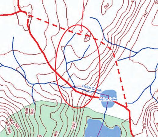
8 FOCAL AREA: LOWER GORST CREEK
9 GORST CREEK OVERLAY IN UGA Created 3 Zones: 50, 85, 150 In addition to SMP/CAO more protective applies Provides incentive-based approach to riparian restoration for redevelopment Remove in-stream structures Retain native vegetation Restore with native trees, shrubs, groundcover at 2:1 ratio (hierarchy: native coniferous, deciduous, other native)
10 HABITAT DEVELOPMENT STANDARDS Provide a landscape plan that demonstrates that at least 20% of the significant trees on the buildable area of the site are retained outside of buffers. Site plan includes a minimum 35-foot habitat corridor (not otherwise required by critical area or shoreline or management overlay regulations) vegetated with native trees, shrubs and groundcover that connect critical areas or permanently preserved natural areas within or adjacent to and across the project site. Site design shall ensure that lighting from adjacent development does not intrude on corridor.

11 WATERSHED CHARACTERIZATION: A DECISION TO SUPPORT TOOL Uses Water Flow/Water Quality Process as Drivers to: ID and prioritize areas for restoration/protection/conservation/development Scale-able: Puget Sound WRIA Gorst Creek Provides High Level Guidance on Management Actions Fine Scale requires additional data and analysis
Improving access to regional conservation assessments through an online encyclopedia
 Western Washington University Western CEDAR Salish Sea Ecosystem Conference 2014 Salish Sea Ecosystem Conference (Seattle, Wash.) May 2nd, 1:30 PM - 3:00 PM Improving access to regional conservation assessments
HUDSON VALLEY REGIONAL COUNCIL 3 Washington Center, Newburgh NY
 PROJECT AREA: HYDE PARK HUDSON VALLEY REGIONAL COUNCIL 3 Washington Center, Newburgh NY 12550 http://www.hudsonvalleyregionalcouncil Insert aerial site photo with streets labeled GREEN INFRASTRUCTURE CONCEPT
Blue/Green Infrastructure Study Accomack County, VA
 Blue/Green Infrastructure Study Accomack County, VA Draft Asset Maps March 8-9, 2010 Green Infrastructure Center, Inc. 2 Overview What is Green and Blue Infrastructure Project Timeline & Tasks Literature
Rural Land Use Designations Kittitas County December 6, 2007 Draft
 KITTITAS COUNTY COMMUNITY DEVELOPMENT SERVICES 411 N. Ruby St., Suite 2, Ellensburg, WA 98926 CDS@CO.KITTITAS.WA.US Office (509) 962-7506 Fax (509) 962-7682 Rural Land Use Designations Kittitas County
Stormwater Standards. Clackamas County Service District No. 1. Planting Guide for Buffers
 Stormwater Standards Clackamas County Service District No. 1 APPENDIX B Planting Guide for Buffers Table of Contents Appendix B - Planting Guide for Buffers... Page B.1 General... 1 B.1.1 Introduction...
Chapter 3 Site Planning and Low Impact Development
 CHAPTER 3 Site Planning and Low Impact Development Chapter 3 Site Planning and Low Impact Development 3.0 Introduction The City of Charleston requires that major residential, large commercial (>1 acre),
Community LID Workgroup Issue Paper #6
 Community LID Workgroup Issue Paper #6 Topic: Hard and Impervious Surface Coverage Limits Objective: Minimize the amount of hard and impervious surfaces in developments to allow more stormwater to infiltrate
Staff will be providing an overview of the project need, purpose and intent for consideration as part of the Amendment cycle.
 Agenda Item D-2 City of Tacoma Planning and Development Services To: Planning Commission From: Stephen Atkinson, Planning Services Division Subject: Open Space Corridors Project Meeting Date: March 1,
Chapter 9 - Neighborhood Plans
 Illahee Chapter 9 - Neighborhood Plans Vision for Illahee The Illahee Community Plan is a statement reflecting the civic pride and community involvement that has existed for more than 120 years. The community
6Natural. Environment Development Permit Guidelines
 6Natural Bylaw 2600-2016, being "Official Community Plan Bylaw, 2016" Schedule "A" CITY OF ABBOTSFORD OFFICIAL COMMUNITY PLAN Environment Development Permit Guidelines Part V - 6-1 Area Subdivision or
Urban Stormwater Management
 State Regulations and Sustainable Infrastructure April 16, 2011 Urban Stormwater Management Drivers Ecosystem Services LID and Light Imprint New Urbanism Comments MD Stormwater Regulations Larry S. Coffman
New Partners for Smart Growth Conference February 5, 2010
 Dan Stroh, Planning Director City of Bellevue Planning and Community Development Bellevue, WA New Partners for Smart Growth Conference February 5, 2010 Summary of Project Long-range plan update for Bel-Red
Meeting Agenda. City of Guelph. River Systems Advisory Committee. Agenda Items. Item 1, 2 and 3. Item 4 Ward to Downtown Pedestrian Bridge
 Meeting Agenda City of Guelph River Systems Advisory Committee September 19, 2018 City Hall, Meeting Room B From 4:00 to 6:00 p.m. Meeting Chair: Mariette Pushkar Agenda Items Welcome to all Item 1, 2
Goleta Community Plan Update
 Goleta Community Plan Update Ecology, Biology, and Habitats GVPAC Meeting Agenda [Wednesday, December 17, 2008, 6:00PM] Pledge of Allegiance and Roll Call Public Comment Period Administrative December
Surrey Ecosystem Management Study
 Surrey Ecosystem Management Study Green Infrastructure Network Opportunities Public Open House & Information Session June 24 th, 2010 EMS Process Ecological Inventory Ecological Assessment Management Policy
Chapter 2: Strategies for Local Governments Chapter 3: Site Assessment and Design for Low Impact Development. Break Out Group 10:30 am to 12 pm
 Chapter 2: Strategies for Local Governments Chapter 3: Site Assessment and Design for Low Impact Development Break Out Group 10:30 am to 12 pm A Low Impact Development Manual for Coastal South Carolina
City of Surrey Ecosystem Management Study. Integration of ecological processes with land use
 City of Surrey Ecosystem Management Study Integration of ecological processes with land use Natural areas in Surrey are changing as the City grows and evolves. Many important natural areas remain or may
Erik Rundell, Project Manager
 Erik Rundell, Project Manager M.U.R.P., Portland State University Certificate, Commercial Real Estate, University of Washington Graduate Certificate, GIS, University of Wisconsin-Madison B.A. Geography,
Working Group Meeting
 April 4,, 2017 Parks Operations Bldg Working Group Meeting Arts Districts Overview Stormwater/RPA/Stream Considerations First Principles Agenda 7:00pm 7:05pm 7:10pm 7:40pm 8:30pm 9:40pm 9:45pm Welcome
Washington State Growth Management Act: The Basics. Kitsap County Department of Community Development
 Washington State Growth Management Act: The Basics Kitsap County Department of Community Development Purpose/History Enacted in 1990 Amended virtually every year since Manage Growth Concentrating population
Green Infrastructure Policies and Ordinances
 Green Infrastructure Policies and Ordinances October 23, 2013 By Karen Firehock, Green Infrastructure Center 2013 Georgia Urban Forest Council s 23 rd Annual Conference The mission of the nonprofit Green
Natural & Nature-Based Solutions for Risk Reduction & Resilience
 University of Massachusetts Amherst ScholarWorks@UMass Amherst International Conference on Engineering and Ecohydrology for Fish Passage International Conference on Engineering and Ecohydrology for Fish
FAQ S about Restoration Planning FROM THE Department of Ecology WEBSITE:
 FAQ S about Restoration Planning FROM THE Department of Ecology WEBSITE: http://www.ecy.wa.gov/programs/sea/sma/st_guide/smp/restoration/qanda.html Notations in parentheses are staff notes directing you
Growth Management Planning in the Central Puget Sound Region. Today s Presentation. Puget Sound Region. New Partners for Smart Growth
 Growth Management Planning in the Central Puget Sound Region New Partners for Smart Growth Denver, CO January 2006 Today s Presentation Regional growth management in central Puget Sound, WA Regional geographies
Low-Impact Development Code Update. Thurston County Community Stakeholder Group June 25, 2015
 Low-Impact Development Code Update Thurston County Community Stakeholder Group June 25, 2015 Overview The County is required to review its local development codes under the latest NPDES municipal stormwater
Building Ecological Solutions to Coastal Community Hazards: Guidance and NJ Coastal Community Assistance
 Building Ecological Solutions to Coastal Community Hazards: Guidance and NJ Coastal Community Assistance Stacy Small-Lorenz National Wildlife Federation Restore America s Estuaries Summit New Orleans,
Natural Heritage areas are characterized by one or more of the following values:
 SECTION 6: LAND USE POLICIES - NATURAL HERITAGE The Natural Heritage policies reference features and areas that provide ecological functions critical to the survival of all species - including humans.
One County s Success in Linking Watershed Protection and Land Use Planning
 One County s Success in Linking Watershed Protection and Land Use Planning Bob Thompson Porter County Plan Commission March 28, 2012 Indiana Watershed Leadership Academy Population 160,000 Approximately
The Benefits and Challenges Associated with Green Infrastructure Practices
 The Benefits and Challenges Associated with Green Infrastructure Practices Thomas M. Evans ASLA, LEED AP Regional Green Infrastructure Design Services Director OWEA Technical Conference, June 20, 2013
Nick Sigmund, Sr. Zoning Officer
 Nick Sigmund, Sr. Zoning Officer Wisconsin Department of Natural Resources Administrative Code NR 115 under the authority of Wisconsin Statute 59.692, establishes and provides that shoreland zoning regulations
Principles for Ecological Landscape Design in Brownfield Business Parks
 Principles for Ecological Landscape Design in Brownfield Business Parks Part of USDA Forest Service research project # 00-JV-11231300-033: Aligning Social and Ecological Drivers of Urban Landscape Change
TERRESTRIAL NATURAL HERITAGE SYSTEM STRATEGY APPENDIX F: MODEL POLICIES FOR THE IMPLEMENTATION OF THE TARGET TERRESTRIAL NATURAL HERITAGE SYSTEM
 TERRESTRIAL NATURAL HERITAGE SYSTEM STRATEGY APPENDIX F: MODEL POLICIES FOR THE IMPLEMENTATION OF THE TARGET TERRESTRIAL NATURAL HERITAGE SYSTEM C H A P T E R 1 M O D E L P O L I C I E S F O R I M P L
National Association of Conservation Districts. Kris Hoellen Vice President, Sustainable Programs The Conservation Fund September 19, 2013
 National Association of Conservation Districts Kris Hoellen Vice President, Sustainable Programs The Conservation Fund September 19, 2013 Our Mission The Conservation Fund forges partnerships to conserve
RAIN GARDENS. Task: PART 1 (60 minutes) Student Directions: Steps you will be following: Directions for beginning: Source Information:
 Student Directions: Steps you will be following: Directions for beginning: Source Information:") PART 1 (60 minutes) Student Directions: Your assignment: Steps you will be following: Your neighborhood council is researching the benefits of installing rain gardens in your community. You will read two
PART 1 (60 minutes) Student Directions: Your assignment: Steps you will be following: Your neighborhood council is researching the benefits of installing rain gardens in your community. You will read two
Importance of Master Planning Marcy Colclough
 Importance of Master Planning Marcy Colclough Senior Planner Southwest Michigan Planning Commission WHERE and HOW we develop Land affects Water Quality! 43.2 Acres total 20 Homes 35.8 Acres of open space
New Development Stormwater Guidelines
 New Development Stormwater Guidelines CITY OF MOUNTLAKE TERRACE Table of Contents Introduction... 2 Ecology s Minimum Requirements for stormwater management... 2 Description of the 9 Minimum Requirements...
Riparian Buffer on the Bushkill Creek. Policies
 Riparian Buffer on the Bushkill Creek Riparian buffers provide numerous benefits to landowners and the community by protecting groundwater recharge areas, providing flood control, providing stormwater
An Update on the Air Force Pilot Project: Developing the Florida Strategic Plan for Sustaining Military Readiness through Conservation Partnerships
 An Update on the Air Force Pilot Project: Developing the Florida Strategic Plan for Sustaining Military Readiness through Conservation Partnerships 18 November 2015 Quick Overview Pilot Project Background
This presentation has been developed by the Sustainable Sites Initiative for general audiences
 This presentation has been developed by the Sustainable Sites Initiative for general audiences Copyright 2011 by the Sustainable Sites Initiative. All rights reserved. 2011 2010 Sustainable Sites Initiative
Minnesota Department of Natural Resource - Natural Resource Guidance Checklist Conserving Natural Resources through Density Bonuses
 Minnesota Department of Natural Resource - Natural Resource Guidance Checklist Conserving Natural Resources through Density Bonuses NRDB Why Use Density Bonuses & This Checklist Local units of government
City of Surrey Ecosystem Management Study. Integration of ecological processes with land use
 City of Surrey Ecosystem Management Study Integration of ecological processes with land use Natural areas in Surrey are changing as the City grows and evolves. Many important natural areas remain or may
STORMWATER SITE PLAN INSTRUCTIONS AND SUBMITTAL TEMPLATE Medium and Large Projects
 DEPARTMENT OF COMMUNITY DEVELOPMENT 621 Sheridan Street, Port Townsend, WA 98368 Tel: 360.379.4450 Fax: 360.379.4451 Web: www.co.jefferson.wa.us/communitydevelopment E-mail: dcd@co.jefferson.wa.us STORMWATER
How to Update a Storm Water Management Program (SWMP) to Incorporate Total Maximum Daily Load (TMDL) BMPs
 to Incorporate Total Maximum Daily Load (TMDL) BMPs") How to Update a Storm Water Management Program (SWMP) to Incorporate Total Maximum Daily Load (TMDL) BMPs Janine Rybka Cuyahoga Soil & Water Conservation District About Habitat Habitats are the places
How to Update a Storm Water Management Program (SWMP) to Incorporate Total Maximum Daily Load (TMDL) BMPs Janine Rybka Cuyahoga Soil & Water Conservation District About Habitat Habitats are the places
Deb Grube, Sr. Zoning Officer
 Deb Grube, Sr. Zoning Officer Wisconsin Department of Natural Resources Administrative Code NR 115 under the authority of Wisconsin Statute 59.692, establishes and provides that shoreland zoning regulations
Richton Park Western Development Corridor Green Infrastructure Development Plan August 18, 2017
 Richton Park Western Development Corridor Green Infrastructure Development Plan August 18, 2017 Conservation Design Forum Geosyntec Consultants 403 W. St. Charles Road 1420 Kensington Road, Suite 103 Lombard,
ROSS Appendix F Land Conversion. Ecosystem Services Value Lost from Land Conversion in the Central Puget Sound Region ( )
") Ecosystem Services Value Lost from Land Conversion in the Central Puget Sound Region (1992-2011) 1 Purpose The purpose of this study is to estimate, in dollars, the value of annual ecosystem services in
Ecosystem Services Value Lost from Land Conversion in the Central Puget Sound Region (1992-2011) 1 Purpose The purpose of this study is to estimate, in dollars, the value of annual ecosystem services in
Landscape Conservation Design April, 2014
 Designing Sustainable Landscapes in the Northeast A project of the North Atlantic Landscape Conservation Cooperative & Northeast Climate Science Center Landscape Conservation Design April, 2014 Conceptual
Introduction. Integrating Ecological Restoration of Estuarine Shorelines with Urban Community Revitalization Efforts. Ed Morgereth Biohabitats, Inc.
 Introduction Integrating Ecological Restoration of Estuarine Shorelines with Urban Community Revitalization Efforts Ed Morgereth Biohabitats, Inc. 5 th National Conference & Expo on Coastal and Estuarine
Stream Restoration: Working with Nature?
 Stream Restoration: Working with Nature? Greg Jennings, PhD, PE jenningsenv@gmail.com Ecosystem Restoration activities that initiate or accelerate the recovery of ecosystem health, integrity, and sustainability
Stream Restoration: Working with Nature? Greg Jennings, PhD, PE
 Stream Restoration: Working with Nature? Greg Jennings, PhD, PE jenningsenv@gmail.com Ecosystem Restoration activities that initiate or accelerate the recovery of ecosystem health, integrity, and sustainability
Conservation Corridor Planning and Green Infrastructure Themes
 Conservation Corridor Planning and Green Infrastructure Themes Prepared by the Green Infrastructure Center Inc. and the Northern Virginia Regional Commission February 22, 2011 Brief Overview Project Background
Landscape Conservation Design June, 2014
 Designing Sustainable Landscapes in the Northeast A project of the North Atlantic Landscape Conservation Cooperative & Northeast Climate Science Center June, 2014 Adaptive Establish Conservation Goals
Infrastructure, Development and Enterprise Services. Natural Heritage Action Plan (NHAP) Project Initiation
 Project Initiation") Staff Report To Service Area Committee of the Whole Infrastructure, Development and Enterprise Services Date Monday, March 6, 2017 Subject Natural Heritage Action Plan (NHAP) Project Initiation Report
Staff Report To Service Area Committee of the Whole Infrastructure, Development and Enterprise Services Date Monday, March 6, 2017 Subject Natural Heritage Action Plan (NHAP) Project Initiation Report
2011 ASLA Design Awards. Westside Creeks Restoration Plan Merit Award AECOM, Fort Collins. Planning & Urban Design
 2011 ASLA Design Awards Westside Creeks Restoration Plan Merit Award AECOM, Fort Collins Planning & Urban Design Project Fact Sheet Category of Entry: Rotating Specialty Award: 2011 2011 ASLA Colorado
Regional Restoration Planning:
 Regional Restoration Planning: A Case Study in Collaborative Restoration Science and Planning Campbell Ingram, Executive Officer NCER August 28, 2018 Co-Equal Responsibilities Act as a primary state agency
Green Infrastructure. NYS Department of Environmental Conservation
 Green Infrastructure Green infrastructure is an interconnected network of natural areas and open spaces that sustains ecosystems. Benedict, M.A. and E.T. McMahon. 2006. Green Infrastructure Linking Landscapes
STORMWATER GREEN INFRASTRUCTURE AND PLANNING/ZONING BOARDS
 STORMWATER GREEN INFRASTRUCTURE AND PLANNING/ZONING BOARDS Source: Center for Watershed Protection, 2007 Southern Tier Central Regional Planning & Development Board Chemung County Stormwater Team OUTLINE
4. What are the goals of the Kawarthas, Naturally Connected project? 7. What are watersheds and why are they being used as the project boundaries?
 Frequently Asked Questions (FAQs) 1. What are Natural Heritage Systems (NHS)? 2. Why are they important? 3. Which areas of the province have undertaken NHS projects? 4. What are the goals of the Kawarthas,
systems is available on the Colorado Wetland Information Center (CWIC) website.
 website.") Colorado Natural Heritage Program Wetland Program Plan -- Dec 2015 Status Update and Addendum -- The Colorado Natural Heritage Program (CNHP) developed a Wetland Program Plan (WPP) in 2010 for the planning
Colorado Natural Heritage Program Wetland Program Plan -- Dec 2015 Status Update and Addendum -- The Colorado Natural Heritage Program (CNHP) developed a Wetland Program Plan (WPP) in 2010 for the planning
Climate$impacts$on$land8use and land8cover$change
 ScienceTheme#4: Climateimpactsonland8use and land8coverchange AndrewMilliken StakeholderOutreachandSciencePlanningMeeting,January2013 NorthAtlanticLandscapeConservationCoordinator,U.S.FishandWildlife Landscape)Conservation)Cooperatives:
TRCA Roles and Responsibilities in Planning and Development
 TRCA Roles and Responsibilities in Planning and Development Regional Watershed Alliance November 14, 2018 Laurie Nelson, MCIP, RPP Associate Director, Planning and Policy Outline Roles and Legislation
MUCKLESHOOT INDIAN TRIBE Fisheries Division nd Avenue SE. Auburn, Washington
 MUCKLESHOOT INDIAN TRIBE Fisheries Division 39015-172nd Avenue SE. Auburn, Washington 98092-9763 Phone: (253) 939-3311. Fax: (253) 931-0752 Mr. David Radabaugh Shoreline Planer W A Dept. of Ecology 3190
NJ Department of Environmental Protection
 NJ Department of Environmental Protection COASTAL AND LAND USE PLANNING New Jersey Coastal Management Program Covers NJ coastal waters to limit of tidal influence including 239 municipalities in 19 counties,
The Five Components of the McLoughlin Area Plan
 The Five Components of the McLoughlin Area Plan This documents contains the complete language of the five components of the McLoughlin Area Plan: The Vision Statement The Values The Guiding Principles
WEFTEC.06. ** City of Caldwell, Idaho
 COST-BENEFIT ANALYSIS OF URBAN STORMWATER RETROFITS AND STREAM DAYLIGHTING USING LOW IMPACT DEVELOPMENT TECHNOLOGIES Sherrill Doran*, Dennis Cannon** * CH2M HILL, 322 East Front Street, Suite 200 Boise,
PARKS AND RECREATION
 PARKS AND RECREATION WHAT YOU WILL FIND IN THIS CHAPTER: Background information on the development of the Park, Recreation, and System Plan (PRSP). General overview of Ellensburg s parks and recreation
Silverdale Regional Center
 Silverdale Regional Center Vision for Silverdale Regional Center The Silverdale Regional Center Plan (Plan) will guide the evolution of the Silverdale Regional Center from a collection of strip malls and
Florida Forever Conservation Needs Assessment Overview Maps
 Florida Forever Conservation Needs Assessment Overview Maps Prepared by Florida Natural Areas Inventory, The maps in this document are derived from the Florida Forever Conservation Needs Assessment, an
Aquatic, Terrestrial and Landscape Conservation Design Tools and Products of the North Atlantic LCC
 Aquatic, Terrestrial and Landscape Conservation Design Tools and Products of the North Atlantic LCC Scott Schwenk Science Coordinator, North Atlantic LCC Chesapeake Bay FWS Partners Meeting Annapolis,
City of Tacoma Shoreline Master Program Update Stakeholder Advisory Committee Meeting September 10, 2009
 City of Tacoma Shoreline Master Program Update Stakeholder Advisory Committee Meeting September 10, 2009 Agenda Overview Progress to Date Upcoming Schedule Structure of the SMP Shoreline Environment Designations
Introduction to the Shoreline Master Program (SMP) Update. City of Bellingham Planning Department 2005
 Update. City of Bellingham Planning Department 2005") Introduction to the Shoreline Master Program (SMP) Update City of Bellingham Planning Department 2005 Purpose of tonight s meeting: Specify which water-bodies are subject to the SMP. Identify the State
Introduction to the Shoreline Master Program (SMP) Update City of Bellingham Planning Department 2005 Purpose of tonight s meeting: Specify which water-bodies are subject to the SMP. Identify the State
3-2 Environmental Systems
 3-2 Environmental Systems 3.0 ENVIRONMENTAL SYSTEMS CONTENTS 3.1 GREENWAY SYSTEM 3.1.1 General Policies 3.1.2 Natural Heritage Network 3.1.3 Natural Heritage Network Enhancement Lands 3.1.4 Rouge Watershed
As a homeowner in the Pacific Northwest, you
 Archival Copy. For current information, see the OSU Extension Catalog:https://catalog.extension.oregonstate.edu Taking Care of streams in Eastern Washington, A Homeowner s Guide to Riparian Areas PNW 557
Template for Restoration in a Lake Superior Area of Concern. Template for Restoration in a Lake Superior Area of Concern
 Keith Bowers, Principal Ivette Bolender, Great Lake Bioregion Team Leader Presentation outline: Project background Master planning process Habitat restoration approach Lessons learned Hog Island and Newton
Shoreland Protection in Maine Communities of the Piscataqua River Estuary
 University of New Hampshire University of New Hampshire Scholars' Repository PREP Reports & Publications Institute for the Study of Earth, Oceans, and Space (EOS) 5-2010 Shoreland Protection in Maine Communities
Great Lakes Conservation Blueprint for Terrestrial Biodiversity on the Canadian Shield
 Great Lakes Conservation Blueprint for Terrestrial Biodiversity on the Canadian Shield Bonnie L. Henson 1, Kara E. Brodribb 2 and John L. Riley 3 1 Ontario Ministry of Natural Resources 2,3 The Nature
5/22/2012. Low Impact Development through NPDES Permits TAKE AWAY MESSAGES. Municipal Stormwater NPDES Permits
 Low Impact Development through NPDES Permits Ed O Brien eobr461@ecy.wa.gov 360/407-6438 TAKE AWAY MESSAGES Municipal SW permits will require LID on new and redevelopment projects Site LID: necessary but
Design Around Waterways and Wetlands
 Design Around Waterways and Wetlands NL Green Economy Conference Newleef-2014 NEIA, St. John s, NL October 9-10 th, 2014 Wade Lewis Amherst, Nova Scotia, w_lewis@ducks.ca DUC conserves, restores and manages
Chapter 131 GENERAL REFERENCES
 Chapter 131 STREAM CORRIDOR PROTECTION ZONE 131-1. Objectives. 131-2. Definitions. 131-3. Establishment of the Stream Corridor Protection Zone. 131-4. Uses permitted. 131-5. Uses expressly prohibited.
Section 3 Non-Structural BMPs
 3.1 Stream Buffers A stream buffer or stream setback is a designated area around a stream, lake, or wetland left in a natural, densely vegetated state so as to protect the receiving water quality and provide
PARK CITY MUNICIPAL CODE TABLE OF CONTENTS TITLE 15 LAND MANAGEMENT CODE - CHAPTER 2.21
 PARK CITY MUNICIPAL CODE TABLE OF CONTENTS TITLE 15 LAND MANAGEMENT CODE - CHAPTER 2.21 TITLE 15 - LAND MANAGEMENT CODE CHAPTER 2.21 - SENSITIVE LAND OVERLAY ZONE (SLO) REGULATIONS 15-2.21-1. PURPOSE...1
Stevens County Partnership Shoreline Master Program Update
 Stevens County Partnership Shoreline Master Program Update Public Open Houses 1 Overview Welcome and open house purpose Overview of Shoreline Management Act (SMA) Shoreline Master Program (SMP) update
Sustainable Land Management Plan for Springbrook Farm
 Sustainable Land Management Plan for Springbrook Farm EnvSt 399: Scott Barvir, Laura Carpenter, Aika Mengi, Daniel Novak Objectives: Aerial Photo of Springbrook Farm Base Map of Springbrook Farm Forest:
FUNDAMENTAL BUILDING BLOCKS
 FUNDAMENTAL BUILDING BLOCKS THE WEB OF GIBSONS - EXISTING Lacks Community Structure and Support Circulation, surface water flow and buildings are disjointed from the community Social neighbourhoods are
Structural Measures at a Glance
 Structural Measures at a Glance 1 Combined Approaches (Notional Graphic) www.nyc.gov Sea Level Change 2 Sandy s Rebuild By Design Effort: Hoboken www.rebuildbydesign.org 3 Courtesy of the Office of Metropolitan
SECTION UNIFIED DEVELOPMENT ORDINANCE SECTION Part 1 Ordinance. ARTICLE 1 Zoning Districts
 SECTION 1-100 UNIFIED DEVELOPMENT ORDINANCE SECTION 1-300 Part 1 Ordinance SECTION 1-100. Introduction. ARTICLE 1 Zoning Districts Crystal Lake strives to maintain a balance of various land uses for a
Best Practices Appendix: Waterfront Communities
 Redevelopment Ready Communities Best Practices Appendix: Waterfront Communities revised September 2014 Waterfront RRC defined The purpose of these additional criteria is to provide waterfront communities
Regional Open Space Conservation Plan. Regional Staff Committee January 18, 2018
 Regional Open Space Conservation Plan Regional Staff Committee January 18, 2018 Schedule We are here Task 1 - Stakeholder Input & Work Plan Dev. v z 2016 2017 2018 Oct Nov Dec Jan Feb Mar Apr May Jun Jul
Toronto Complete Streets Guidelines
 Toronto Complete Streets Guidelines 108 110 7.1 Green Infrastructure Design Principles 112 7.2 Context-Sensitive Green Streets 114 7.3 Key Green Street Elements Green infrastructure refers to natural and
Vaughan Metropolitan Centre (VMC) Black Creek Renewal CLASS ENVIRONMENTAL ASSESSMENT
 Black Creek Renewal CLASS ENVIRONMENTAL ASSESSMENT") PUBLIC INFORMATION CENTRE Vaughan Metropolitan Centre (VMC) Black Creek Renewal Wednesday, May 10, 2017 6:00 p.m. to 8:00 p.m. Add photo Project Management, Environmental Assessment, Stormwater Management
PUBLIC INFORMATION CENTRE Vaughan Metropolitan Centre (VMC) Black Creek Renewal Wednesday, May 10, 2017 6:00 p.m. to 8:00 p.m. Add photo Project Management, Environmental Assessment, Stormwater Management
Parks, Open Space and Trails
 Introduction Parks have often been referred as the lungs of our cities, cleansing the air of pollutants and particulate matter. Parks are also gathering places for families and community. They offer spaces
International Green Roof City Network Case Study Seattle, Washington USA
 International Green Roof City Network Case Study Seattle, Washington USA 1) City Data Location Seattle, Washington is located in the Pacific Northwest of the United States. The city is situated between
Central Lake Ontario Conservation Conservation Lands Master Plan
 Conservation Lands Master Plan Top 13 Frequently Asked Questions 1. What are conservation lands? Where are these conservation lands located in the Central Lake Ontario Conservation watershed? Conservation
COMPLETE GREEN STREET CHECKLIST
 COMPLETE GREEN STREET CHECKLIST This document was developed to dissect the structure of an urban street and explore opportunities to make our streets more complete while also integrating green street strategies.
City of Tacoma Planning and Development Services
 Agenda Item D-1 City of Tacoma Planning and Development Services To: Planning Commission From: Elliott Barnett, Planning Services Division Subject: Application #2014-08 Open Space Element Update Meeting
Anne Arundel County s Severn River Watershed Implementation Strategy. Severn River Association
 Anne Arundel County s Severn River Watershed Implementation Strategy Severn River Association Watershed Protection and Restoration Program Anne Arundel County Department of Public Works August 18, 2014
Innovative Land Use Techniques
 Innovative Land Use Techniques A Handbook for Sustainable Development Eric Williams, Assistant Administrator, NHDES Carolyn Russell, Principal Planner, NHDES Cliff Sinnott, Executive Director, RPC Jill
A LOW IMPACT DEVELOPMENT MANUAL FOR COASTAL SOUTH CAROLINA TABLE OF CONTENTS
 A LOW IMPACT DEVELOPMENT MANUAL FOR COASTAL SOUTH CAROLINA TABLE OF CONTENTS Chapter 1: 1.1 to LID 1.2 Manual Purpose and Application 1.3 Environmental Benefits of LID 1.4 Economic Benefits of LID Case
CAO Update Status Work continues on products: Draft ordinance BAS report CAO process summary (2002 to present) Comprehensive e Plan policy review Some
 Comprehensive e Plan policy review Some") Critical Areas Ordinance Update Wetlands Andrew Deffobis Jeremy Davis Cynthia Wilson Thurston County Planning April 6, 2011 CAO Update Status Work continues on products: Draft ordinance BAS report CAO
Critical Areas Ordinance Update Wetlands Andrew Deffobis Jeremy Davis Cynthia Wilson Thurston County Planning April 6, 2011 CAO Update Status Work continues on products: Draft ordinance BAS report CAO
Community Design Guidelines. Port Wallace DRAFT
 Community Design Guidelines Port Wallace DRAFT Energy 1 2 3 Nature Movement Connections Built Form DRAFT Layout Energy 1 Nature Community Design Guidelines GREAT COMMUNITIES PROTECT, CELEBRATE, AND CONSERVE