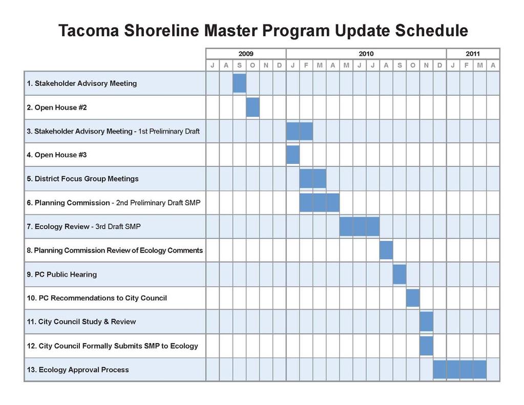
City of Tacoma Shoreline Master Program Update Stakeholder Advisory Committee Meeting September 10, 2009
|
|
|
- Gordon Patterson
- 5 years ago
- Views:
Transcription
1 City of Tacoma Shoreline Master Program Update Stakeholder Advisory Committee Meeting September 10, 2009
2 Agenda Overview Progress to Date Upcoming Schedule Structure of the SMP Shoreline Environment Designations (SEDs( SEDs) Shoreline Districts & Boundaries Land Uses
3 Overview State requires update of SMP by 2011 Initiated process in 2006 with shoreline critical areas Prepared draft study documents Changes in CAPO completed in 2008 Re-initiate focus on SMP now through 2010
4 Draft Study Documents Prepared: Inventory & Characterization Report Public Access Plan Use Analysis Restoration Plan Thea Foss Public Access Study Thea Foss Design Guidelines
5


6 Structure of the SMP
7 Table of Contents Introduction Goals & Policies Shoreline Environments Shoreline Districts Permit and Administrative Procedures (codified) Development Regulations & Standards (codified) Appendices
8 Shoreline Environment Designations What are they? A nomenclature to differentiate the variety of conditions along the shoreline SEDs serve as the tool for prescribing appropriate levels of protection for distinct areas of the shoreline
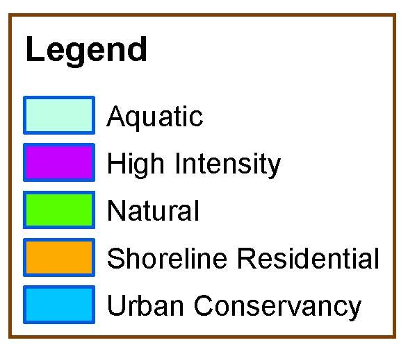
9 Shoreline Environment Designations What can be considered in Tacoma? High Intensity Shoreline Residential Urban Conservancy Natural Aquatic or Alternative systems
10 Shoreline Environment Designations What are some of the designation criteria? Existing land use pattern Biological and physical character Goals and aspirations of the community
11 Shoreline Environment Designations Tacoma s s approach: Existing SEDs are largely appropriate Change only where obviously needed for: Critical resource protection Consistency with underlying district boundaries As directed by the Comprehensive Plan unless new information directs a Comp Plan change
12 Shoreline Environment Designations What must the SMP include for each designation: Purpose statement Classification criteria Management policies Regulations (per shoreline district)
13 Components
14 Existing Shoreline Designations
15 Factors for Analysis Bulkheads/armoring Historic Fill Overwater Structures Vegetation Fish and Wildlife Habitat Conservation Areas and Buffers Nearshore Processes Comprehensive Plan Land Use Intensities Existing Land Use Patterns Goals and Aspirations of the Community (?)
16 Bulkheading

17 Historic Fill
18 Overwater Structures
19 Vegetation

20 Nearshore Processes

21 Fish and Wildlife Habitat Conservation Area Buffers

22 Comprehensive Plan Land Use Intensities

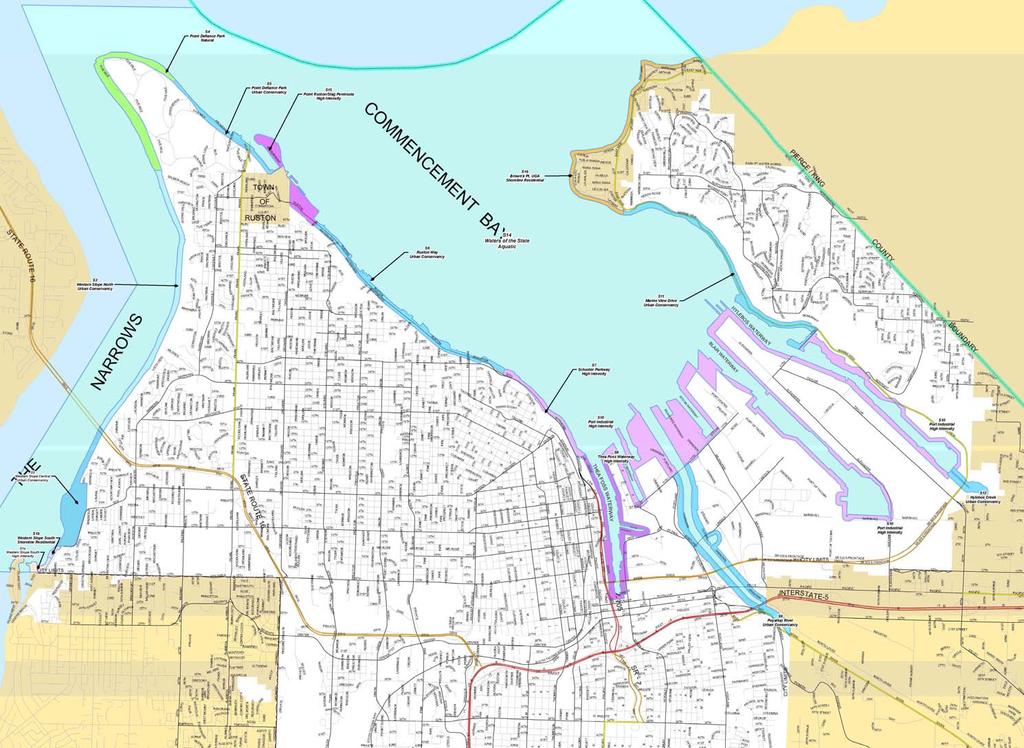
23 Natural/conservancy Name: Brown s Pt. UGA Proposed: Shoreline Residential Aquatic Name: Point Ruston Existing Designation: Urban Proposed: High Intensity Name: Marine View Drive Existing Designation: Urban Proposed: Urban Conservancy Conservancy High Intensity High Intensity Name: Hylebos Creek Existing Designation: Urban Proposed: Urban Conservancy Name: Narrows Marina/Day Island Existing Designation: Urban Proposed: High Intensity and Shoreline Residential Name: Puyallup River Existing Designation: Urban Proposed: Urban Conservancy Name: Ruston Way Existing Designation: Urban Proposed: Urban Conservancy
24 High Intensity 50 Buffer Potential restoration sites Narrows Marina Patchy kelp University Place Shoreline Jurisdiction

25 Direction of Longshore Transport Overwater residences Urban - Conservancy 115 Buffer Shoreline Residential 50 Buffer Patchy Kelp and Eelgrass High Intensit y Intensity 50 Buffer

26 Land Use Patterns

27 Longshore Drift Urban - Conservancy 115 Buffer Existing Restoration Site Slag Peninsula: Cleanup Site Patchy Kelp throughout High Intensity 50 Buffer
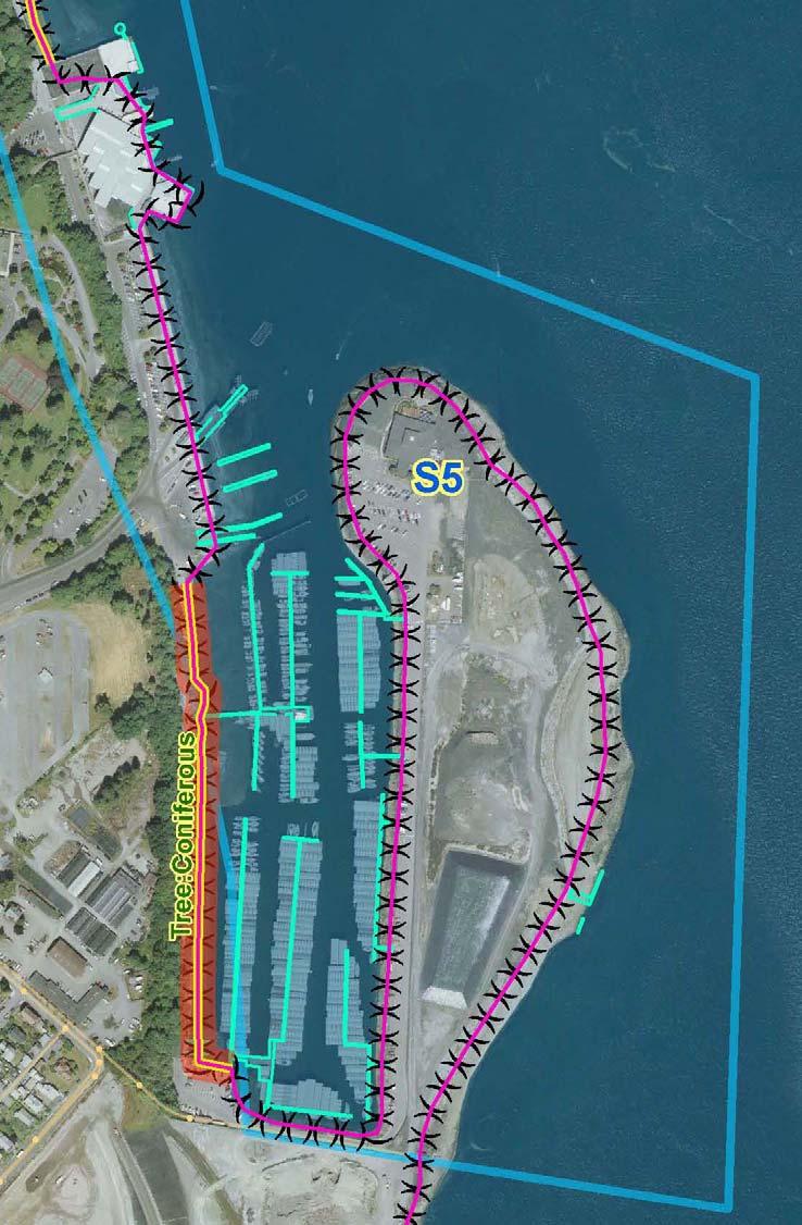
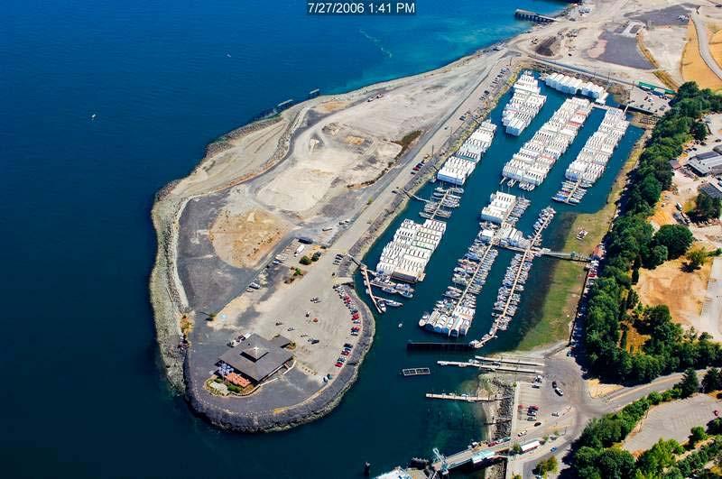
28

29 Town of Ruston Jurisdiction Patchy Kelp Beds High Intensity 50 Buffer

30 Potential Restoration Site Longshore Drift Urban - Conservancy 115 Buffer High Intensity 50 Buffer
31
32 Shoreline District Boundaries Analysis and Recommendations City of Tacoma Shoreline Master Program Update
33 Existing City of Tacoma Shoreline Districts

34 Potential Boundary Changes Former Asarco Site S13: Commencement Bay Marine View Dr. Districts 11 & 12 Chinese Reconciliation Park And Salt Marsh S-1: Multi family and single family residential; 6 th Ave Park Hylebos Creek

35 Narrows Marina: S1 Shoreline District
36 Character of the Area Overwater residential and multifamily Water-dependent marina and boat launch facilities Single family residential

37 Current District Boundary Proposed District Boundary (6 th Ave ROW)
38 Residential Character Cluster of multifamily Residential Division between multiand single family residences Shoreline Residential High Intensity

39 Point Ruston/Ruston Way: S6 Slag Peninsula Point Ruston: Former Asarco Smelter site RUSTON

40 Character of the Area

41 Chinese Reconciliation Park and Salt Marsh: S7 District Ruston Way S6 Chinese Reconciliation Park And Salt Marsh Sperry Ocean Dock

42 Character of the Area Existing salt marsh Restoration site Site of Chinese Reconciliation Park (In construction)

43 Hylebos Creek: S10 Port/Industrial Uses Hylebos Creek Port/Industrial Uses

44 Marine View Drive: S11 and S12
45 Proposed Designations
46 Environment Designations vs. Designations Shoreline Districts Broad management policies Districts Define allowed and prohibited uses Specific development
47 Example: Different Designations Natural Policy: maintain intact ecological functions through preservation S-4 4 District Limited uses allowed 200-ft nearshore buffer Vegetation preservation requirements High Intensity Policy: maintain waterfront location for water-dependent uses S-10 District Water-dependent industry, port facilities and marinas allowed Other uses restricted 50-ft nearshore buffer
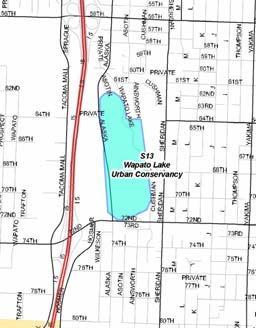
48 Example: Same Designation - Different Districts Urban Conservancy Policy: Promote public access and recreation Policy: Preserve and restore ecological functions Policy: Allow variety of uses while meeting no net loss S-6 6 District Ruston Way Good public access; few in-water/over water/over-water uses Water-enjoyment enjoyment and recreation 115-ft marine buffer Height standards S-12 District Marine View Drive North Less public access; more water-dependent uses (marinas) Low density overwater residential 115-ft marine buffer S-14 District Wapato Lake Fewer allowed uses Wetland buffers ft
49 What we want to take away Set the stage for the next discussion Encourage comment on proposed designations and boundaries Increase understanding of what role these designations play Achieve a preliminary consensus on high level concepts
Shoreline Master Program Town of La Conner, Washington
 Shoreline Master Program Town of La Conner, Washington Department of Ecology approval effective Adopted September 24, 2013 by Town of La Conner Ordinance No.1106 Amended May 13, 2014 by Town of La Conner
Public Visioning City of Kelso Planning Commission
 Shoreline Master Program Update Public Visioning City of Kelso Planning Commission November 13, 2012 Schedule Jurisdiction Inventory Analysis Visioning Topics Process Governing Principles Structure of
Introduction to the Shoreline Master Program (SMP) Update. City of Bellingham Planning Department 2005
 Update. City of Bellingham Planning Department 2005") Introduction to the Shoreline Master Program (SMP) Update City of Bellingham Planning Department 2005 Purpose of tonight s meeting: Specify which water-bodies are subject to the SMP. Identify the State
Introduction to the Shoreline Master Program (SMP) Update City of Bellingham Planning Department 2005 Purpose of tonight s meeting: Specify which water-bodies are subject to the SMP. Identify the State
I am writing regarding the SMP update draft as a citizen and a neighbor who is impacted by shoreline uses.
 From: Rick & Judy Rose [mailto:stadium_rose@earthlink.net] Sent: Wednesday, November 03, 2010 5:00 PM To: Planning; satkinson@cityoftacoma.org; Community@walkthewaterfront.org Cc: clark.mather@mail.house.gov;
Staff will be providing an overview of the project need, purpose and intent for consideration as part of the Amendment cycle.
 Agenda Item D-2 City of Tacoma Planning and Development Services To: Planning Commission From: Stephen Atkinson, Planning Services Division Subject: Open Space Corridors Project Meeting Date: March 1,
Ashbridges Bay Erosion and Sediment Control Project
 Ashbridges Bay Erosion and Sediment Control Project Project Brief Overview Toronto and Region Conservation Authority, in partnership with the City of Toronto, intends to carry out remedial erosion control
Stevens County Partnership Shoreline Master Program Update
 Stevens County Partnership Shoreline Master Program Update Public Open Houses 1 Overview Welcome and open house purpose Overview of Shoreline Management Act (SMA) Shoreline Master Program (SMP) update
Clallam County Shoreline Master Program Update. Salt Creek and Tongue Point, 2006
 Clallam County Shoreline Master Program Update Salt Creek and Tongue Point, 2006 Presentation to the Sequim Association of Realtors 23 February 2011 Why Shoreline Master Program? Accommodate future development
City of Tacoma Planning and Development Services
 Agenda Item D-1 City of Tacoma Planning and Development Services To: Planning Commission From: Elliott Barnett, Planning Services Division Subject: Application #2014-08 Open Space Element Update Meeting
City of Tacoma Planning and Development Services
 Agenda Item D-3 City of Tacoma Planning and Development Services To: Planning Commission From: Stephen Atkinson, Associate Planner, Planning Services Division Subject: Land Use Designations - Phase 2 Meeting
YEAR 2 FIRST QUARTER REPORT
 ENVIRONMENTAL STEWARDSHIP PROJECT YEAR 2 FIRST QUARTER REPORT DECEMBER 23, 2009 Prepared for: NATIONAL OCEANIC AND ATMOSPHERIC ADMINISTRATION Prepared by: CITY OF TACOMA 1.0 Introduction In accordance
Chapter 14. Shorelines
 Chapter 14 Shorelines Contents City of Spokane Comprehensive Plan 14.1 INTRODUCTION... 7 14.2 SPOKANE S SHORELINE MASTER PROGRAM...11 14.3 ENVIRONMENTS AND MANAGEMENT POLICIES...15 14.5 GOALS AND POLICIES...22
Gibsons Foreshore & Seawalk Improvements
 Gibsons Foreshore & Seawalk Improvements Open House (5:00-7:00 pm) Town of Gibsons October 6, 2016 Town of Gibsons Foreshore & Seawalk Improvements 1 Session 3: Open House (Charrette Participants, Designers,
City of Tacoma Community & Economic Development Department
 City of Tacoma Community & Economic Development Department Agenda Item GB-1 TO: FROM: SUBJECT: Planning Commission Stephen Atkinson, Comprehensive Planning Division Shoreline Public Access Alternatives
4. What are the goals of the Kawarthas, Naturally Connected project? 7. What are watersheds and why are they being used as the project boundaries?
 Frequently Asked Questions (FAQs) 1. What are Natural Heritage Systems (NHS)? 2. Why are they important? 3. Which areas of the province have undertaken NHS projects? 4. What are the goals of the Kawarthas,
Welcome. Tannery and Waterworks Parks Shoreline Improvements Environmental Assessment. Public Information Centre #1 November 27, pm to 8 pm
 Welcome Tannery and Waterworks Parks Shoreline Improvements, Environmental Assessment Tannery and Waterworks Parks Shoreline Improvements Environmental Assessment #1 6 pm to 8 pm Why We Are Here Tannery
VIRGINIA KEY CONSENSUS MASTER PLAN
 VIRGINIA KEY CONSENSUS MASTER PLAN JULY 2010 Existing Conditions JULY 2010 STAKEHOLDER INTERVIEW PROCESS, January 18-22, 2007 PUBLIC MEETING #1: SITE INVENTORY AND ANALYSIS, March 29, 2007 PUBLIC MEETING
Walk plan will lead to future
 Walk plan will lead to future LARA HERRMANN AND MARKUS DENNIS Published: April 20th, 2008 For more than 60 years, Tacomans have dreamed of a continuous shoreside walk along Commencement Bay, from the foot
Port of San Diego Sea Level Rise Ad Hoc Committee Meeting 1 of 3.. September 18, 2018
 Port of San Diego Sea Level Rise Ad Hoc Committee Meeting 1 of 3. September 18, 2018 Agenda Welcome Introductions Rules of the Ad-Hoc Presentation Background Vulnerability Assessment Results Non-Agenda
Chelsea Creek Municipal Harbor Plan
 Chelsea Creek Municipal Harbor Plan Public Meeting #1 June 11th, 2018 1 Presentation outline I. Introduction: Why are we doing this plan? II. Evolution of Chelsea Creek III. State of Chelsea Creek IV.
Planning for Staten. Habitat Restoration and Green Infrastructure. Island s North Shore
 Habitat Restoration and Green Infrastructure Planning for Staten Island s North Shore Community Board 1 March 1, 2018 NYC Parks Forestry, Horticulture, and Natural Resources Funded by the NYS Department
CITY OF BELLINGHAM PLANNING DEPARTMENT STAFF REPORT
 1 1 1 1 1 1 1 1 0 1 0 1 0 1 0 CITY OF BELLINGHAM PLANNING DEPARTMENT STAFF REPORT Agenda Topic: For: Staff Contact: I. Project Summary Review of the Waterfront District subarea plan and associated documents,
TERMS OF REFERENCE MALASPINA COMPLEX COASTAL PLAN
 TERMS OF REFERENCE MALASPINA COMPLEX COASTAL PLAN A. RATIONALE Land and Water BC, resource user groups and the Powell River Regional District have requested that the Ministry of Sustainable Resource Management
PDS June 1, 2016 Page 1. Planning and Development Committee. MEETING DATE: Wednesday, June 01, 2016
 Page 1 REPORT TO: Planning and Development Committee MEETING DATE: Wednesday, June 01, 2016 SUBJECT: ROPA 12: Project Initiation Report Regional Official Plan Amendment (ROPA # 12) Watercourse Policies
Manchester. Vision for Manchester
 Manchester Vision for Manchester The Manchester Community Plan is a statement of the community values and aspirations for the future. This is an effort to recognize what originally attracted visitors in
Master Plan for Preservation and Scenic Conservation (1995)
") 3.2 Master Plan for Preservation and Scenic Conservation (1995) The Master Plan for Preservation and Scenic Conservation was developed under the direction of the Guilford Preservation Alliance in the 1980s
3.2 Master Plan for Preservation and Scenic Conservation (1995) The Master Plan for Preservation and Scenic Conservation was developed under the direction of the Guilford Preservation Alliance in the 1980s
Welcome. to the Bull Shoals Lake Master Plan Revision Open House
 Welcome to the Bull Shoals Lake Master Plan Revision Open House At the open house you can: Learn about the project Provide comments on the Draft Master Plan and Draft Environmental Assessment (EA) Watch
Advice from Department of Ecology
 Advice from Department of Ecology The simplest way to reduce landslide risk is to avoid slideprone areas in the first place. Simple practices such as building a house farther from the edge of a steep slope,
APPENDIX L3. Table of Contents. SWP EA Information Sheets
 E N V I R O N M E N T A L A S S E S S M E N T APPENDIX L3 SWP EA Information Sheets Table of Contents EA Info Sheet 1... L3-1 EA Info Sheet 2... L3-3 EA Info Sheet 3... L3-5 EA Info Sheet 4... L3-7 SCARBOROUGH
PLANNING ADVISORY BOARD AGENDA OCTOBER
 ! City of Langley PLANNING ADVISORY BOARD AGENDA OCTOBER 1, 2014 3-5pm LANGLEY CITY HALL - 112 2 nd Street, Langley WA 1) Call to Order and Roll Call 2) Approval of the Minutes September 10, 2014 3) Public
STEWARDSHIP OF LONG ISLAND SOUND S ECOLOGICAL AND RECREATIONAL RESOURCES
 STEWARDSHIP OF LONG ISLAND SOUND S ECOLOGICAL AND RECREATIONAL RESOURCES Robin Kriesberg, Save the Sound, Inc. Thomas Halavik, US Fish and Wildlife Service Coastal Program An Initiative to Identify, Protect
MAYFIELD WEST SECONDARY PLAN PHASE 2
 MAYFIELD WEST SECONDARY PLAN PHASE 2 Council Information Workshop February 16, 2010 Draft Preferred Land Use Plan TOWN OF CALEDON PLANNING & DEVELOPMENT DEPARTMENT Workshop Agenda TOWN OF CALEDON 1. Welcome
SHORELINE MASTER PROGRAM
 SHORELINE MASTER PROGRAM 2013 CITY OF PORT ORCHARD CITY OF PORT ORCHARD MARCH 2013 REVISED FEBRUARY 2018 Page 2 City of Port Orchard Shoreline Master Program March 2013 Rev. Feb 2018 ACKNOWLEDGEMENTS MAYOR
City Center Neighborhood Plan
 [1] City Center Neighborhood Plan As adopted by Ordinance No. 2014-09-049 and amended by Ordinance Nos. Formerly CBD Neighborhood as adopted by Ordinance No. 8868 and amended by Ordinance Nos. 8946, 9693,
Options for addressing City of Edmonds Alternatives to Ecology s Required Changes addressing Edmonds Marsh Buffers and Setbacks.
 Options for addressing City of Edmonds Alternatives to Ecology s Required Changes addressing Edmonds Marsh Buffers and Setbacks. This document presents Ecology s response to the City of Edmonds alternatives
TO: Port of Orcas FROM: Tina Whitman, Science Director SUBJECT: Master Plan Update DATE: September 7, 2018
 TO: Port of Orcas FROM: Tina Whitman, Science Director SUBJECT: Master Plan Update DATE: September 7, 2018 Friends of the San Juans appreciates the opportunity to provide input to the Port of Orcas Master
Welcome! Agenda. South Downtown
 Welcome! Agenda 4:00 Open House 5:00 Presentation Welcome Subarea Plan Overview Existing Studies Next steps: Scoping 6:00 Questions and Answers 6:30 Open House continues Project background and purpose
Kevin M. Rampe, President -- Lower Manhattan Development Corporation
 For Internal Use Only: Date Received: WRP no. DOS no. NEW YORK CITY WATERFRONT REVITALIZATION PROGRAM Consistency Assessment Form Proposed actions that are subject to CEQR, ULURP or other local, state
STUDY AREA. Tonight s Agenda. Project Tasks Completed. Next Steps. Town of Oyster Bay Eastern Waterfront Community Vision & Revitalization Plan
 Town of Oyster Bay Eastern Waterfront Community Vision & Revitalization Plan Public Meeting January 27, 2009 Opening Remarks Presentation Tonight s Agenda Introduction Study Area Overview Public Participation
Planning Commission March 14, Presented by: City of Bellingham Port of Bellingham
 Planning Commission March 14, 2013 Presented by: City of Bellingham Port of Bellingham 1 Agenda Waterfront District Background Waterfront District Proposal Overview Sub-area Plan Development Regulations
Sustainable Natural Environment Wetlands
 Town of Huntsville Official Plan Review - POLICY BACKGROUND PAPER Sustainable Natural Environment Wetlands BACKGROUND: Wetlands are an important natural resource. The ecological, social and economic benefits
Waterfront Redevelopment. City Council Briefing May 15, 2006
 Waterfront Redevelopment City Council Briefing May 15, 2006 Topics Reason for this presentation Recap of recent waterfront events Marina/Park economic and feasibility evaluation Planned next steps Recap
OFFICIAL COMMUNITY PLANS (OCPs) AND ZONING BYLAWS (ZBs): PLANNING FOR THE FUTURE
 AND ZONING BYLAWS (ZBs): PLANNING FOR THE FUTURE") OFFICIAL COMMUNITY PLANS (OCPs) AND ZONING BYLAWS (ZBs): PLANNING FOR THE FUTURE Official Community Plan Workshop January 20, 2016 Frontier, SK SARM Community Planning Services SARM the voice of rural
OFFICIAL COMMUNITY PLANS (OCPs) AND ZONING BYLAWS (ZBs): PLANNING FOR THE FUTURE Official Community Plan Workshop January 20, 2016 Frontier, SK SARM Community Planning Services SARM the voice of rural
CLACKAMAS COUNTY ZONING AND DEVELOPMENT ORDINANCE
 704 RIVER AND STREAM CONSERVATION AREA (RSCA) 704.01 PURPOSE Section 704 is adopted to: A. Maintain the integrity of the rivers and streams in the County by minimizing erosion, promoting bank stability,
FAQ S about Restoration Planning FROM THE Department of Ecology WEBSITE:
 FAQ S about Restoration Planning FROM THE Department of Ecology WEBSITE: http://www.ecy.wa.gov/programs/sea/sma/st_guide/smp/restoration/qanda.html Notations in parentheses are staff notes directing you
CHAPTER ONE INTRODUCTION
 1.0 Introduction Bellingham s central waterfront is in a state of transition from its long history as an active industrial site to a new mixed-use neighborhood. Over the past several years, the Port of
Raystown Lake Master Plan Revision. Public Meeting April 25 & 26, 2018 How does the revision process work?
 Raystown Lake Master Plan Revision Public Meeting April 25 & 26, 2018 How does the revision process work? What is a Master Plan? The Master Plan is the strategic land use management document that guides
Deb Grube, Sr. Zoning Officer
 Deb Grube, Sr. Zoning Officer Wisconsin Department of Natural Resources Administrative Code NR 115 under the authority of Wisconsin Statute 59.692, establishes and provides that shoreland zoning regulations
CAO Update Status Work continues on products: Draft ordinance BAS report CAO process summary (2002 to present) Comprehensive e Plan policy review Some
 Comprehensive e Plan policy review Some") Critical Areas Ordinance Update Wetlands Andrew Deffobis Jeremy Davis Cynthia Wilson Thurston County Planning April 6, 2011 CAO Update Status Work continues on products: Draft ordinance BAS report CAO
Critical Areas Ordinance Update Wetlands Andrew Deffobis Jeremy Davis Cynthia Wilson Thurston County Planning April 6, 2011 CAO Update Status Work continues on products: Draft ordinance BAS report CAO
Preserving Recreational & Commercial Working Waterfronts. Jennifer Z. Carver, AICP August 2007
 Preserving Recreational & Commercial Working Waterfronts Jennifer Z. Carver, AICP August 2007 Why is this an Issue? Legislation Definitions Comprehensive Planning Requirements Tools HB 955, Waterfront
City of Kingston. North King s Town Secondary Plan Open House + Workshop #1 February 28, 2018
 City of Kingston North King s Town Secondary Plan Open House + Workshop #1 February 28, 2018 1 event agenda 30 min Panel Review + Discussion 30 min Presentation + Q&A 75 min Workshop Session 15 min Report
MAYFIELD WEST SECONDARY PLAN PHASE 2
 MAYFIELD WEST SECONDARY PLAN PHASE 2 Public Open House #3 February 25, 2010 Draft Preferred Land Use Scenario TOWN OF CALEDON PLANNING & DEVELOPMENT DEPARTMENT Open House Agenda TOWN OF CALEDON 1. Welcome
Joe Pool Lake Lake Master Plan Public Information Meeting Presentation of Final Draft Revision July 31, 2018
 Joe Pool Lake Lake Master Plan Public Information Meeting Presentation of Final Draft Revision July 31, 2018 Presented By Jeremy Spencer Lake Manager U.S. Army Corps of Engineers Fort Worth District US
April 11, 2016 Park Board Chair and Commissioners General Manager Vancouver Board of Parks and Recreation New Brighton Salt Marsh - Preferred Concept
 TO: FROM: SUBJECT: April 11, 2016 Park Board Chair and Commissioners General Manager Vancouver Board of Parks and Recreation New Brighton Salt Marsh - Preferred Concept RECOMMENDATION A. THAT the Vancouver
Nick Sigmund, Sr. Zoning Officer
 Nick Sigmund, Sr. Zoning Officer Wisconsin Department of Natural Resources Administrative Code NR 115 under the authority of Wisconsin Statute 59.692, establishes and provides that shoreland zoning regulations
Cherry Beach Shoreline Protection Infrastructure Conceptual Design and Class EA
 Welcome Cherry Beach Shoreline Protection Infrastructure Conceptual Design and Class EA May 3, 2012 Study Area Cherry Beach neighbourhood is located in lower Stoney Creek on Lake Ontario, east of Millen
PARKS AND RECREATION
 PARKS AND RECREATION WHAT YOU WILL FIND IN THIS CHAPTER: Background information on the development of the Park, Recreation, and System Plan (PRSP). General overview of Ellensburg s parks and recreation
Brice Prairie Master Plan
 Brice Prairie Master Plan Town of Onalaska Community Meeting #1 Sand Lake Elementary School January 28, 2006 9 am 11 am Agenda Background What is a Master Plan? Brice Prairie Capacity Reports Starter Ideas
Discussion: ELSI comments re Colwood Draft Official Community Plan
 File: 0360-20 Esquimalt Lagoon Stewardship Initiative AGENDA Steering Committee Tuesday, December 12, 2017 2:30 4:30 p.m. Committee Room, Colwood Municipal Hall TIME ACTIVITY RESPONSIBILITY 2:30 Approval
Baselands Trails Master Plan Public Meeting. April 28, 2015 Fire Academy, 895 Eastern Avenue, Toronto 6:30 p.m. to 9:00 p.m.
 Baselands Trails Master Plan Public Meeting April 28, 2015 Fire Academy, 895 Eastern Avenue, Toronto 6:30 p.m. to 9:00 p.m. Baselands Trails Master Plan Meeting Purpose To present and get feedback on:
Town of Peru Comprehensive Plan Executive Summary
 Town of Peru Comprehensive Plan Executive Communities that plan grow by choice, not by chance. A plan makes growth thoughtful, understandable, and predictable. A plan shows that a community is managing
6 PORT SYDNEY SETTLEMENT AREA
 Section 6 Port Sydney Page 61 6 PORT SYDNEY SETTLEMENT AREA 6.1 Basis and Principles Village of Port Sydney Waterfront Community Existing Services 6.1.1 Port Sydney is an historic settlement that has developed
Pine Flat Lake Master Plan Update FACT SHEET September 2014
 Pine Flat Lake Master Plan Update FACT SHEET September 2014 PURPOSE AND OBJECTIVE The U.S. Army Corps of Engineers Sacramento District is revising the 1976 Pine Flat Lake Master Plan and is seeking public
Conservation Corridor Base and Thematic Maps
 Conservation Corridor Base and Thematic Maps August 20, 2010 This project is funded in part by the Virginia Coastal Zone Management Program at the Department of Environmental Quality through Grant #NAO9NOS4190163
PARTF Scoring System for Grants
 PARTF Scoring System for Grants The members of the N.C. Parks and Recreation Authority use the PARTF scoring system as one of several tools to select grant recipients. Please provide all of the information
WASHINGTON COUNTY OREGON
 WASHINGTON COUNTY OREGON LONG RANGE PLANNING DIVISION North Bethany Subarea Stream Corridors: Existing Regulations In Oregon, there is a distinct difference between the land use rules that apply in rural
Preservation of Recreational and Commercial Working Waterfronts
 Session Title: Planning for Working s Preservation Wednesday, November 1, 2006 4:25pm Preservation of Recreational and Commercial Working s Marlene Conaway Florida Department of Community Affairs, Division
LAND USE ELEMENT. Purpose. General Goals & Policies
 LAND USE ELEMENT Purpose This Land Use Element contains the goals and policies necessary to support the City s responsibility for managing land resources and guiding development through implementing regulations,
Point Defiance Park. Master Plan Update. April 23 rd 2015
 Point Defiance Park Master Plan Update April 23 rd 2015 Public Participation 1/29, 2/26, 3/26 & 4/23 Tonight s Agenda: Introduction: March Meeting Recap: Overview Feedback Responses Presentation of Master
Cohasset Municipal Harbor Plan Public Meeting #1. Harriman GEI Consultants FXM Associates May 31, 2018
 Public Meeting #1 Harriman GEI Consultants FXM Associates Agenda Welcome and Introductions Planning Study: Purpose and Process Municipal Harbor Planning 101 Existing Conditions Creating a Vision for the
Lake O the Pines Master Plan Revision Public Information Meeting April 25 & 27, 2017
 Lake O the Pines Master Plan Revision Public Information Meeting April 25 & 27, 2017 Presented By Matthew Like, Lake Manager U.S. Army Corps of Engineers Fort Worth District US Army Corps of Engineers
Mississauga Waterfront. Parks Strategy - Draft
 Potential configuration for river s edge seating. Boating on Credit River: A regatta Boating on Credit River: Active enjoyment 5.2 Port Credit Memorial Park West Priority Park 5.2.1 Site Opportunities
CHAPTER 4 FUTURE LAND USE AND URBAN SERVICES DISTRICTS
 CHAPTER 4 FUTURE LAND USE AND URBAN SERVICES DISTRICTS Introduction This chapter discusses how Benzie County should grow and change in the future. A community can grow and change in many different ways.
The Planning Partnership Baird + Associates TCI Management Consultants Ltd. Plan B Natural Heritage Wills Consulting Engineers Poulos & Chung Limited
 Little Lake Master Plan The Planning Partnership Baird + Associates TCI Management Consultants Ltd. Plan B Natural Heritage Wills Consulting Engineers Poulos & Chung Limited May 26, 2009 Purpose of Study
LU Encourage schools, institutions, and other community facilities that serve rural residents to locate in neighboring cities and towns.
 Application No. 891627: Comprehensive Plan Text Amendment - Rural School Policies - Amend policies consistent with State Legislation allowing schools in the rural area and extension of sewer service to
MAKING LIVABLE AND ATTRACTIVE WATERFRONTS
 MAKING LIVABLE AND ATTRACTIVE WATERFRONTS Introduction In the past twenty-five years there has been a significant transformation in the use of waterfront areas across the United States. The decline in
City of Richland Comprehensive Plan: Integrated Non-project Final Environmental Impact Statement
 City of Richland Comprehensive Plan: Integrated Non-project Final Environmental Impact Statement September 12, 2017 Prepared for: City of Richland Prepared by: Oneza & Associates With assistance from:
COMPREHENSIVE PLAN & UNIFIED DEVELOPMENT ORDINANCE
 Village of Forsyth COMPREHENSIVE PLAN & UNIFIED DEVELOPMENT ORDINANCE Community Planning #6 Prepared by: Vision Statement We envision the Forsyth Community as one which will continue to maintain a small
DISCUSSION TOPIC: ST JOHNS RIVER & ITS TRIBUTARIES (BPII) 2030 COMPREHENSIVE PLAN POLICES AND REGULATORY FRAMEWORK
 2030 COMPREHENSIVE PLAN POLICES AND REGULATORY FRAMEWORK") DISCUSSION TOPIC: ST JOHNS RIVER & ITS TRIBUTARIES (BPII) 2030 COMPREHENSIVE PLAN POLICES AND REGULATORY FRAMEWORK St. John s River & Its Tributaries Issue Summary: The St. Johns River is an important
DISCUSSION TOPIC: ST JOHNS RIVER & ITS TRIBUTARIES (BPII) 2030 COMPREHENSIVE PLAN POLICES AND REGULATORY FRAMEWORK St. John s River & Its Tributaries Issue Summary: The St. Johns River is an important
SHORELINE, FLOOD AND COASTAL DEFENCE MANAGEMENT PLANS
 These plans may provide opportunities as well as concern for recreational boating. They are currently being revised and consulted on. This document explains how we can engage in the process. Shoreline,
6 Utility Systems Utility System Policies 6.2 Implementation Strategies 7 Parks, Open Space and Trails 63
 Draft Sub-Area Plan 2012 Prepared by the Port of Bellingham and the City of Bellingham, with assistance from CollinsWoerman, the Waterfront Advisory Group and many other Whatcom County citizens and volunteers.
AREA-WIDE PEDESTRIAN AND BICYCLE CIRCULATION
 OUSD LANEY CHILD CARE CENTER ART BUILDING LANEY COLLEGE BALL FIELDS PCCD OFFICES PERALTA PARK AQUATIC CENTER & ESTUARY PARK EDOFF MEMORIAL BANDSTAND SNOW PARK COURT HOUSE OAKLAND MUSEUM OAK ST AREA-WIDE
New Brighton Park Shoreline Habitat Restoration Project
 Vancouver Board of Parks and Recreation and Port Metro Vancouver New Brighton Park Shoreline Habitat Restoration Project Conceptual Design Public Consultation August 26 September 9, 2015 Discussion Paper
Gibsons Foreshore & Seawalk Improvements
 Gibsons Foreshore & Seawalk Improvements Mini-Charrette - Presentation Town of Gibsons October 6, 2016 Our Team Consulting Team Dave Murray, Project Manager, Water Resources Engineer, KWL David Reid, Facilitator,
MUCKLESHOOT INDIAN TRIBE Fisheries Division nd Avenue SE. Auburn, Washington
 MUCKLESHOOT INDIAN TRIBE Fisheries Division 39015-172nd Avenue SE. Auburn, Washington 98092-9763 Phone: (253) 939-3311. Fax: (253) 931-0752 Mr. David Radabaugh Shoreline Planer W A Dept. of Ecology 3190
Preface. Erie. Scranton. Allentown. Pittsburgh. Harrisburg. Philadelphia
 The Southern Alleghenies Region The Southern Alleghenies Region spans the Laurel Highlands and Allegheny Front in the west across the Appalachians to the east. It is comprised of Blair, Bedford, Cambria,
Appendix C Agency Correspondence
 Appendix C Agency Correspondence Appendix C: Correspondence TRAFFIC From: The City of White Plains, Department of Traffic To: Metro-North Railroad Date: March 3, 2009 Subject: Describes the basis for determining
Rural Land Use Designations Kittitas County December 6, 2007 Draft
 KITTITAS COUNTY COMMUNITY DEVELOPMENT SERVICES 411 N. Ruby St., Suite 2, Ellensburg, WA 98926 CDS@CO.KITTITAS.WA.US Office (509) 962-7506 Fax (509) 962-7682 Rural Land Use Designations Kittitas County
PHASE ONE. A summary report: What the community told Alcoa during Phase One of the community engagement program for Point Henry 575.
 PHASE ONE A summary report: What the community told Alcoa during Phase One of the community engagement program for Point Henry 575. DECEMBER 2015 FEBRUARY 2016 INTRODUCTION In 2014 Alcoa closed its Point
3. VISION AND GOALS. Vision Statement. Goals, Objectives and Policies
 Vision Statement Queen Creek s interconnected network of parks, trails, open spaces and recreation opportunities provide safe and diverse activities and programs that sustain its unique, small town, equestrian
Folly Beach Planning Commission
 Folly Beach Planning Commission September 10, 2018 7:00 PM REGULAR MEETING ---------------------------------------------------------------------------------------------------- Commission Members: Greg
Introduction to the Seahurst Park Ecosystem Restoration Project: A Process of Transformation. Presented by Peter Hummel, ASLA, LEED AP
 Introduction to the Seahurst Park Ecosystem Restoration Project: Presented by Peter Hummel, ASLA, LEED AP September 16, 2014 Environmental Science Center Public Education Series 0 Acknowledgements Project
TACOMA WATERFRONT. Design Guidelines
 TACOMA WATERFRONT Design Guidelines INTRODUCTION 1 Thea Foss Waterway 2 Schuster Parkway 3 Schuster Parkway Transition 4 Ruston Way Shoreline 5 Point Ruston/Slag Peninsula Shoreline 6 OBJECTIVES 7 USE
U.S. Army Corps of Engineers, Los Angeles District Prado Basin Project Updates
 U.S. Army Corps of Engineers, Los Angeles District Prado Basin Project Updates Host: Inland Empire Utilities Agency January 19, 2017 10:00 a.m. Purpose: To provide project overviews and updates to regional
TRANSFORM BALTIMORE NEW ZONING CODE. Laurie Feinberg, Asst. Director
 Laurie Feinberg, Asst. Director 4/5/2017 1 History and Summary of Process Principles of the code New Designations Use Tables Bulk Regulations Design and Landscape Guidelines Liquor Outlet Reduction Urban
Lewisville Lake Master Plan Revision Public Information Meeting May 2 & 4, 2017
 Lewisville Lake Master Plan Revision Public Information Meeting May 2 & 4, 2017 Presented By Rob Jordan Lake Manager U.S. Army Corps of Engineers Fort Worth District US Army Corps of Engineers Purpose
A Vision for Walnut Creek
 A Vision for Walnut Creek Photo: City of Clive Walnut Creek Booklet 8 of 8 Greater Des Moines Water Trails and Greenways 1 Table of Contents Booklet 1: Water Trails Strategies and Policies Booklet 2: Beaver
Ecosystem Restoration Business Line Budgeting A Systems Approach
 Ecosystem Restoration Business Line Budgeting A Systems Approach Laura Orr (NWS), Shawn Phillips (MVM), Greg Steele (NAO) Introduction Chesapeake Bay Bridge Mouth of Mississippi River Bonneville Dam Fish
WATERFRONT PLACE CENTRAL MIXED USE REDEVELOPMENT PROJECT
 WATERFRONT PLACE CENTRAL MIXED USE REDEVELOPMENT PROJECT View Impact Analysis - Summary Narrative The view impact analysis conducted for the Waterfront Place Central mixed-use redevelopment project proposal
THE PROTECTION OF CHATHAM COUNTY S NATURAL RESOURCES - THE POLICY SIDE
 THE PROTECTION OF CHATHAM COUNTY S NATURAL RESOURCES - THE POLICY SIDE SEA GRANT TIDAL CREEK SUMMIT CHARLESTON, SOUTH CAROLINA DECEMBER 5, 2011 Jackie Jackson Teel Chatham County-Savannah Metropolitan