YEAR 2 FIRST QUARTER REPORT
|
|
|
- Berenice Summers
- 5 years ago
- Views:
Transcription


1 ENVIRONMENTAL STEWARDSHIP PROJECT YEAR 2 FIRST QUARTER REPORT DECEMBER 23, 2009 Prepared for: NATIONAL OCEANIC AND ATMOSPHERIC ADMINISTRATION Prepared by: CITY OF TACOMA
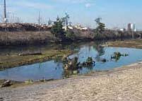
2 1.0 Introduction In accordance with the terms and conditions of the Settlement Agreement between the U.S. Environmental Protection Agency and the City of Tacoma, and the associated Annual Scope of Work, this report presents a financial summary of the Long Term Environmental Site Stewardship Project (ESP) from July through September 2009 and summarizes the work activities from October through December This project was undertaken in connection with the settlement of an enforcement action taken by the United States Environmental Protection Agency for violations of CERCLA. Please refer to Attachment 1 for the current Task List. The (ESP) resulted from the need to provide long-term care for restoration sites within the Commencement Bay/Puyallup River watershed that no longer have regulatory or legal requirements for maintenance, monitoring, or adaptive management. The primary goal of the ESP is to ensure the health of the restoration projects in the Puyallup River watershed so they continue to provide function and value. The City is fulfilling the role of Steward for the following sites: Yowkwala Skookum Wulge Squally Beach Mowitch Jordan/Lower Hylebos Marsh Middle Waterway, City of Tacoma Middle Waterway, Simpson Olympic View, City/DNR Tahoma Salt Marsh Swan Creek The City will continue to fulfill the role of Steward under the direction of the Natural Resource Damage Trustees (Trustees) until such time that the penalty monies which have been placed in escrow for this purpose have been exhausted. 2.0 Site by Site Summaries The following is a site by site summary of general site observations, work completed during the reporting period, summary of data collected, and proposed tasks. 2.1 Yowkwala The Yowkwala site is located on the northeast shore of Commencement Bay near the mouth of the Hylebos Waterway. These 15 acres were set aside for preservation of the shoreline s intertidal habitat areas and native vegetation. The site consists of a rocky beach, a relatively flat backshore, riparian planted area, and a steep forested hillslope behind. The majority of the work on this site will take place in the backslope riparian planting area. Access to this site is primarily from a private marina parking lot, Tyee Marina, to the southeast. In addition, there are two pullouts above the hillslope off of Marine View Drive that provide viewing areas, but no access points. 1
3 This site was set aside by the Trustees, and a beach cleanup including the removal of two derelict barges was completed in In recent years, Citizens for a Healthy Bay (CHB) has been working under agreement with the Trustees to perform stewardship, monitoring, and maintenance activities at this site. With the execution of the Settlement Agreement, the City is now providing stewardship of this site. The City and CHB are working cooperatively to ensure that the efforts of each entity are complementary. CHB provides regular reporting of their activities to the Trustees under separate cover. The City s bi-monthly site visits took place on October 8 and December 3. Photo documentation was not required during this quarter s monitoring. Trash and invasive species removal are the primary concerns at this site. Nightshade was added as an invasive species present at the site. Black raspberry (Rubus leucodermis) was noted as a volunteer on-site and is located toward the northern end of the site. Additional plantings will be needed on site as invasive species are removed. Dri-water or some other means of temporary irrigation and mulch may be needed during plant establishment. During the site visits, evidence of recent beach bonfires and associated party trash were noted. This is a long-standing problem at this site. Also removal and relocation of the photo point markers was noted. Quarterly monitoring data are summarized in the data spreadsheet (see Table 1 in Attachment 2). November 18 WCC completed garbage sweep of site. In addition to these activities, CHB performed a planting, mulching, and invasive species removal volunteer event on December 5. ongoing invasive species removal, and garbage pick-up. 2.2 Skookum Wulge The Skookum Wulge site is located on the northeast shore of Commencement Bay near the mouth of the Hylebos Waterway. This narrow strip of 1.19 acres has been set aside for preservation of the shoreline s intertidal habitat areas and native vegetation. The site consists of a rocky beach, a small backshore embayment, and an upper riparian planted area. There is approximately a 3-4 foot elevation difference between the planted area and the upper beach due to erosion. The majority of the work on this site will take place in the riparian planting area, although some erosion protection measures may take place on the upper beach. Access to this site is primarily from a turnout off of Marine View Drive adjacent to the site. This site was set aside by the Trustees for protection in No active restoration of the site happened initially. In recent years, CHB has been working under agreement with the Trustees to perform stewardship, monitoring, and maintenance activities at this site. With the execution of the Settlement Agreement, the City is now providing stewardship of this site. The City and CHB are working cooperatively to ensure that the efforts of each entity are complementary. CHB provides regular reporting of their activities to the Trustees under separate cover. The City s bi-monthly site visits took place on October 8 and December 3. Photo documentation was not required during this quarter s monitoring. Invasive removal and new, native plantings are the primary activities which are needed at this site. Invasive species continue to be present at the south end of the site and include blackberry, ivy, morning glory, pepperweed and 2
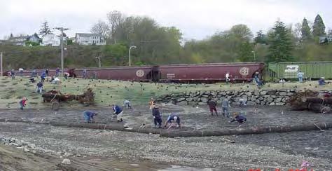
4 Japanese Knotweed. No new invasive species were noted. No new volunteer species were noted. There is some ongoing erosion of the shoreline occurring, and the placement of large woody debris (LWD) for erosion protection should be considered. The City will be pursuing a conceptual design and estimate with a consultant for Trustee review. Quarterly monitoring data are summarized in the data spreadsheet (see Table 2 in Attachment 2). October 14, 20, and 22 WCC prepared the north half of the site for topsoil placement and hydroseed application; October 23 and 24 City s Streets and Grounds Division performed topsoil placement and hydroseeding; November 7 CHB held volunteer planting/mulching event (see Attachment 3 for Planting Plan); WCC performed QA/QC on planting area; November 18 WCC completed garbage sweep of site. garbage pick-up, and working on the development of a conceptual plan and estimate for placement of LWD for erosion control. 2.3 Squally Beach The Squally Beach site is located on the northeast shore of Commencement Bay just north of the 11 th Street Bridge. Seeps from the hill above are diffused over the shoreline creating an area of brackish marsh and backwater pools. This 0.66 acre site provides intertidal habitat, riparian habitat, and native vegetation. The site consists of small raised island areas within the marsh area. A wooded strip of riparian area separates the site from the adjacent roadway. The majority of the work will take place in the marsh area, but some work may be required in the wooded area adjacent to the roadway. Access to the site is from a turnout off of Marine View Drive toward the northwest end of the site. Development of this site was completed by the Trustees in In recent years, CHB has been working under agreement with the Trustees to perform stewardship, monitoring, and maintenance activities at this site. With the execution of the Settlement Agreement, the City is now providing stewardship of this site. The City and CHB are working cooperatively to ensure that the efforts of each entity are complementary. CHB provides regular reporting of their activities to the Trustees under separate cover. The City s bi-monthly site visits took place on October 8 and December 3. Photo documentation was not required during this quarter s monitoring. Cordgrass was identified as a new invasive species on-site. No new volunteer species were noted. Knotweed control on the adjacent site to the northwest is ongoing. It is anticipated that the knotweed will again be injected in Quarterly monitoring data are summarized in the data spreadsheet (see Table 3 in Attachment 2). November 18 WCC completed garbage sweep of site. 3
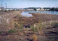
5 In addition to these activities, CHB performed invasive removal volunteer events on October 17 and October 24 which also included the repair of the 30 feet of shoreline fencing. garbage pick-up, ongoing invasive species removal, and working on the development of a conceptual plan and estimate for placement of LWD for erosion control and prevention of accumulation of excessive LWD in the marsh area. 2.4 Mowitch The Mowitch site is located at the head of the Hylebos Waterway. This 2.3 acre site provides intertidal backwater fingers that enable brackish marsh vegetation to grow and foraging and refuge habitat for salmonids. The site consists of one island marsh area and three other marsh areas separated by backchannel areas. An upland riparian zone separates the habitat area from an adjacent industrial site. The majority of the work on this site will take place in the marsh areas. Access to the site is from the southeast corner of the site off of Marine View Drive and adjacent to the railroad tracks. Development of this site was completed by the Trustees in In recent years, CHB has been working under agreement with the Trustees to perform stewardship, monitoring, and maintenance activities at this site. With the execution of the Settlement Agreement, the City is now providing stewardship of this site. The City and CHB are working cooperatively to ensure that the efforts of each entity are complementary. CHB provides regular reporting of their activities to the Trustees under separate cover. The City s initial bi-monthly site visits took place on October 8 and December 10. Photo documentation was not required during this quarter s monitoring. No new volunteer or invasive species were noted. Quarterly monitoring data are summarized in the data spreadsheet (see Table 4 in Attachment 2). November 18 WCC completed garbage sweep of site. garbage pick-up, removal of the large posted goose exclusion devices and ongoing invasive species removal. 2.5 Jordan/Lower Hylebos Marsh The Jordan/Lower Hylebos Marsh site is located directly adjacent to Hylebos Creek in Fife, just downstream of the 4 th Street bridge. The 15.3 acres site provides off channel intertidal habitat for fish migration, rearing, foraging, and refuge. The site consists of a steep, wooded hillslope, a public walking trail, planted riparian areas, marsh areas, and islands. The majority of work at this site will be performed in the planted riparian and marsh areas, as well as on the islands. Some work may be performed on the lower hillslope adjacent to the walking path. Access to the site is from 4 th Street East or 8 th Street East at the northwest or southeast sides of the site, respectively. Development of this site was completed by the Trustees in In recent years, the non-profit group Friends of the Hylebos (FOH) has been working under agreement with the Trustees to 4
6 perform stewardship, monitoring, and maintenance activities at this site. With the execution of the Settlement Agreement, the City is now providing stewardship of this site. The City and FOH are working cooperatively to ensure that the efforts of each entity are complementary. To date, FOH has provided regular reporting of their activities to the Trustees under separate cover. Their stewardship work at the site was completed in June The City s bi-monthly site visits took place on October 8 and December 10. Photo documentation was not required during this quarter s monitoring. No new invasive or volunteer species were noted. Alder continue to thrive at the site and additional thinning may be needed. Quarterly monitoring data are summarized in the data spreadsheet (see Table 5 in Attachment 2). October 27 and 28 WCC crew brush cut blackberry on east side of trail and performed garbage pick-up. The crew also reset the small stewardship sign placed near the educational project sign. garbage pick-up, ongoing invasive species removal, procurement of planting materials for spring supplemental planting to the east side slope of the trail, and thinning of the alder as needed. 2.6 Middle Waterway, City of Tacoma The Middle Waterway, City of Tacoma site is located at the head of the Middle Waterway near 11 th Street. This 1.85 acre site provides intertidal habitat and salt marsh vegetation beneficial for juvenile salmonid migration. The riparian areas provide habitat for shore birds and other wildlife. The majority of the work at this site will be performed in the marsh area and riparian areas. Access to this site is off of F Street or 11 th Street. This site was constructed by the City of Tacoma in While the City s obligation under its Consent Decree required monitoring and maintenance of the site for only five years, the City has continued to maintain the site since those five years lapsed in The City s bi-monthly site visits under the Settlement Agreement took place on October 21 and December 10. Photo documentation was not required for this quarter s monitoring. No new invasive or volunteer species were noted. Some additional plantings are needed along F Street and in the side riparian area adjacent to the substation. Some mulch may be needed in association with this additional planting. Quarterly monitoring data are summarized in the data spreadsheet (see Table 6 in Attachment 2). November 19 WCC completed garbage sweep of site. garbage pick-up, additional invasive removal, procurement of plants for fall 2010 supplemental planting in the riparian area paralleling F Street and the riparian area adjacent to the substation, and cutting the vegetation back from the adjacent sidewalks on East 11 th Street (see Task List in Attachment 3). 5
7 2.7 Middle Waterway, Simpson The Middle Waterway, Simpson site is located at the head of the Middle Waterway near 11 th Street, and adjacent to the Middle Waterway (City) site. This site provides intertidal habitat and salt marsh vegetation beneficial for juvenile salmonid migration. The riparian areas provide habitat for shore birds and other wildlife. A combination of mudflat areas, beach areas, and bank/wooded areas are present at the site. The majority of the work will take place in the beach areas, however, most of the invasive species removal will occur in the bank/wooded areas. Access to this site is off of the Middle Waterway Access Road. This site was constructed by Simpson in In recent years, Citizens for a Healthy Bay (CHB) has been working under agreement with Simpson to perform stewardship, monitoring, and maintenance activities at this site. With the execution of the Settlement Agreement, the City is now providing stewardship of this site. The City and CHB are working cooperatively to ensure that the efforts of each entity are complementary. CHB provides regular reporting of their activities to the Trustees under separate cover. The City s bi-monthly site visit under the Settlement Agreement took place on December 10. Also, a drive-by inspection was completed on October 21, due to the absence of a signed access agreement with Simpson (property owner). Photo documentation was not required during this quarter s monitoring. A transient encampment was identified in the south woods near 11 th Street. The Tacoma Police Department has been notified. At last visit the camp was still present. No new invasive or volunteer species were noted. Quarterly monitoring data are summarized in the data spreadsheet (see Table 7 in Attachment 2). November 19 WCC completed garbage sweep of the site. garbage pick-up, ongoing invasive removal, mulching around existing plants, supplemental planting in the riparian and salt marsh areas, and associated extension of goose exclosures as needed (see Task List in Attachment 3). 2.8 Olympic View (City) / Olympic View Triangle (DNR) The Olympic View site is located at the tip of the peninsula between the Thea Foss and Middle Waterways. This 12.4 acre site consists of restored beach, tidelands, and riparian areas. Onsite, but just offshore, is one of the few remaining eelgrass beds in Commencement Bay. The majority of the work on this site will take place on the upper beach/riparian area. Access to this site will be from the end of East F Street near Foss Maritime. The Olympic View project that included both cleanup and restoration was constructed by the City of Tacoma in In 2007, the DNR Triangle portion of the site was completed by DNR, including remediation of some contaminated soil and added salt marsh habitat. While the City s obligation under its Consent Decree required monitoring and maintenance of its portion of the site for only five years, the City has continued to maintain the site since those five years lapsed in The City s bi-monthly site visits under the Settlement Agreement took place on October 21 and December 10. Photo documentation was not required during this quarter s monitoring. No new 6
8 volunteer or invasive species were noted. Quarterly monitoring data are summarized in the data spreadsheet (see Table 8 in Attachment 2). November 19 WCC completed garbage sweep at site and removed invasive species. December WCC continued invasive species removal from site. garbage pick-up, additional invasive removal, thinning of the volunteer cottonwoods, monitoring of the newly planted marsh and additional planting as needed based on survivability, and monitoring of erosion in the salt marsh. 2.9 Tahoma Salt Marsh The Tahoma Salt Marsh site is located along the Ruston Way shoreline near the Jack Hyde and Chinese Reconciliation Parks. This 1.95 acre bowl-shaped riparian and salt marsh habitat provides intertidal habitat for juvenile salmonids. The riparian areas provide habitat for shore birds and other wildlife. The site consists of a planted intertidal salt marsh area and surrounding riparian slope. The majority of the work at this site will occur within this bowl area in both the intertidal marsh and riparian zones. Access to this site is through the parking lot located across Ruston Way from Jack Hyde Park. The Tahoma Salt Marsh project was constructed by the City in While the City s obligation under its Consent Decree required monitoring and maintenance of its portion of the site for only five years, the City has continued to maintain the site since those five years lapsed in CHB has also provided some stewardship activities at this site since 2008 on behalf of the Trustees. The City and CHB are coordinating to ensure that activities performed by each entity are complementary. CHB provides separate documentation of their work to the Trustees. The City s bi-monthly site visits under the Settlement Agreement took place on October 21 and December 3. Photo documentation was not required during this quarter s monitoring. No new volunteer or invasive species were noted. Quarterly monitoring data are summarized in the data spreadsheet (see Table 9 in Attachment 2). November 10 Re-secured salt marsh log. November 19 WCC crew completed garbage sweep of site. In addition to these activities, CHB performed a mulching event on December 12. garbage pick-up, and additional invasive removal Swan Creek The Swan Creek site is located just outside the City of Tacoma limits, bordered by Pioneer Way and the railroad tracks. These 12 acres include Swan Creek, the Haire wetland, and associated riparian areas. The created channels provide an improved surface water connection that allows 7
9 easier passage for fish into the wetland complex. This site consists of many habitat types that provide avian, amphibian, and fish habitat for rearing, refuge, and foraging. The majority of the work at this site will take place in the riparian areas and near Channels A and B. Access to this site is from turnouts on Pioneer Way. The Swan Creek project was constructed by the City in While the City s obligation under its Consent Decree required monitoring and maintenance of its portion of the site for only five years, the City has continued to maintain the site since those five years lapsed in The City s bi-monthly site visits under the Settlement Agreement took place on October 21 and December 16. Photo documentation was not required for this quarter s monitoring. Invasive species continue to be the primary concern at this site. No new invasive or volunteer species were noted. New shrubs have been planted in an area at the north end where invasive species had been removed and are doing well. Plant damage by beavers continues to be noted in some areas. This site has some human impacts as well, with social trails and fishing use. Trash is a problem in areas. The chain and bollard barriers on the site are in the process of repair. Expired fish were noted in the main stream. Quarterly monitoring data are summarized in the data spreadsheet (see Table 10 in Attachment 2). October 5-8 WCC crew remove invasives species, approximately 12 cy removed. November 2 Installed jute matting on cleared areas. November 3 Planted 320 plants in cleared areas. November 23 WCC completed garbage sweep at site. December Invasive removal garbage pick-up, ongoing invasive and trash removal, repair of the chain and bollard fence at the north end of the site, and procurement of plants for supplemental spring 2010 planting in the cleared areas. 3.0 Financial Summary Financial information documenting the City s costs for each task performed July 1 through September 30 is provided in Attachment 3. The work performed at each site is summarized in Section 2.0. As documented in Attachment 3, the City incurred the following costs between July 1 and September 30: Task 1 Project Management $2, Task 2 Reporting and Documentation $ Task 3 Site Monitoring $1, Task 4 Site Maintenance* $11, Task 5 Adaptive Management $0.00 General Maintenance and Monitoring $2, Total $18, * Based on WCC crew rate of $45.67/hr 8
City of Tacoma Shoreline Master Program Update Stakeholder Advisory Committee Meeting September 10, 2009
 City of Tacoma Shoreline Master Program Update Stakeholder Advisory Committee Meeting September 10, 2009 Agenda Overview Progress to Date Upcoming Schedule Structure of the SMP Shoreline Environment Designations
Coquitlam River Riparian Planting
 Coquitlam River Riparian Planting Year Four Year Four Report, March 2016 Prepared for: Fish and Wildlife Compensation Program Prepared by: Watershed Watch Salmon Society and the Kwikwetlem First Nation
Baylands Segment J. Bay between the Golden Gate and Segment J. Coyote Point. of For managed ponds. included habitat enhancement.
 Baylands Segment J Crissy Field Alameda Naval Air Station Heron's Head Park COLMA CREEK SFO Millbrae San Mateo BAYLANDS 2009 SAN FRANCISCO AREA san francisco area Western side of central San Francisco
PICTURE CANYON Planning Riparian-Wetland Refugia in an Urban Setting
 PICTURE CANYON Planning Riparian-Wetland Refugia in an Urban Setting Rio De Flag Existing Conditions. Ephemeral stream; Limited riparian plants, habitats.. & Opportunities Water (effluent) available Restore
April 11, 2016 Park Board Chair and Commissioners General Manager Vancouver Board of Parks and Recreation New Brighton Salt Marsh - Preferred Concept
 TO: FROM: SUBJECT: April 11, 2016 Park Board Chair and Commissioners General Manager Vancouver Board of Parks and Recreation New Brighton Salt Marsh - Preferred Concept RECOMMENDATION A. THAT the Vancouver
Stormwater Standards. Clackamas County Service District No. 1. Planting Guide for Buffers
 Stormwater Standards Clackamas County Service District No. 1 APPENDIX B Planting Guide for Buffers Table of Contents Appendix B - Planting Guide for Buffers... Page B.1 General... 1 B.1.1 Introduction...
New Brighton Park Shoreline Habitat Restoration Project
 Vancouver Board of Parks and Recreation and Port Metro Vancouver New Brighton Park Shoreline Habitat Restoration Project Conceptual Design Public Consultation August 26 September 9, 2015 Discussion Paper
Attachment 1. Tables and Figures
 Attachment 1 Tables and Figures Table 1 ESP Site Record ESP Site Record: Yowkwala Observational Categories 8/10/2011 (City) 10/25/11 (CHB) 12/9/11 (CHB) 2/15/2012 (City) 4/19/12 (CHB) 6/15/2012 (CHB) 8/14/2012
Tentatively Selected Plan within Harlem River, East River and Western Long Island Sound Planning Region. First Level Costs. Federal Non-Federal Total
 HARLEM RIVER, EAST RIVER AND WESTERN LONG ISLAND SOUND PLANNING REGION Flushing Bay and Creek Ecosystem Restoration Source Feasibility Study Background Study Resolution (1994), Reconnaissance Report (1996),
Juneau Watershed Partnership
 Juneau Watershed Partnership Native Plant Resource Center Final Report A Partners for Fish and Wildlife Project Prepared for: U.S. Fish and Wildlife Service For Grant #F11C00552 Prepared by: The Juneau
Planning for Staten. Habitat Restoration and Green Infrastructure. Island s North Shore
 Habitat Restoration and Green Infrastructure Planning for Staten Island s North Shore Community Board 1 March 1, 2018 NYC Parks Forestry, Horticulture, and Natural Resources Funded by the NYS Department
Is a Riparian Restoration Still Viable After 100-year Storm Events Alter the Original Design?
 Is a Riparian Restoration Still Viable After 100-year Storm Events Alter the Original Design? Sarah Spear Cooke, Ph.D. Seattle, Washington Presentation Outline Introduction The site pre-restoration Restoration
13 Maintenance and Operations Plan 223
 222 13 Operations Maintenance and Plan 223 Chapter 13 MAINTENANCE AND OPERATIONS PLAN 13.1 Stewardship The Minneapolis Park and Recreation Board (MPRB) is the steward of a nationally-acclaimed park system.
The Rocky Mountain Arsenal and the Northeast Greenway Corridor Project:
 The Rocky Mountain Arsenal and the Northeast Greenway Corridor Project: Contamination to Collaboration Presented by Howard Kenison Overview of Presentation Rocky Mountain Arsenal Contamination Litigation,
Staff will be providing an overview of the project need, purpose and intent for consideration as part of the Amendment cycle.
 Agenda Item D-2 City of Tacoma Planning and Development Services To: Planning Commission From: Stephen Atkinson, Planning Services Division Subject: Open Space Corridors Project Meeting Date: March 1,
Client #: Dawson /91. NRCS Tract #(s): Location: Fleming Memorial Park Field #(s): Program(s): Urban Project Name: Date:
: Location: Fleming Memorial Park Field #(s): Program(s): Urban Project Name: Date:") Natural Resource Stewardship Plan Jackson Soil and Water Conservation District 89 Alder Street Central Point, Oregon 97502 Ph. (541) 664-1070 www.jswcd.org Client Name: Elisa Dawson, City of Rogue River
Natural Resource Stewardship Plan Jackson Soil and Water Conservation District 89 Alder Street Central Point, Oregon 97502 Ph. (541) 664-1070 www.jswcd.org Client Name: Elisa Dawson, City of Rogue River
The scope of the plan will focus on the Prospect Heights Slough and Hillcrest Lake as one entity.
 Plan for Prospect Heights Natural Resources Commission Plan for Improved Public Access and Enjoyment of the Prospect Heights Slough and Hillcrest Lake July 23, 2018 The City Council has requested the Natural
Pine Flat Lake Master Plan Update FACT SHEET September 2014
 Pine Flat Lake Master Plan Update FACT SHEET September 2014 PURPOSE AND OBJECTIVE The U.S. Army Corps of Engineers Sacramento District is revising the 1976 Pine Flat Lake Master Plan and is seeking public
Rule D Wetland and Creek Buffers
 Rule D Wetland and Creek Buffers 1 Policy It is the policy of the Board of Managers to ensure the preservation of the natural resources, recreational, habitat, water treatment and water storage functions
Study Area Map. Wasatch Hollow Open Space Restoration, Use, & Management Plan. Legend. Harrison Ave East. Roosevelt East.
 Harrison Ave Roosevelt Emerson «4 «5 Rosecrest 1900 East «3 1800 East Wasatch Hollow Open Space Restoration, Use, & Management Plan Study Area Map Legend «2 «1 Potential Access Location Emigration Creek
STREAM BANK STABILIZATION THORPS MORTIMER RECREATION AREA Grandfather Ranger District SITE LOCATION & DRAINAGE AREA
 STREAM BANK STABILIZATION THORPS CREEK @ MORTIMER RECREATION AREA SITE LOCATION & DRAINAGE AREA SITE LOCATION Drainage Area = 1.14 sq. miles STREAM BANK STABILIZATION THORPS CREEK @ MORTIMER RECREATION
Planning for Staten. Habitat Restoration and Green Infrastructure. Island s North Shore
 Habitat Restoration and Green Infrastructure Planning for Staten Island s North Shore Walker Park December 7, 2017 NYC Parks Forestry, Horticulture, and Natural Resources Funded by the NYS Department of
ALTERNATIVE SHORELINE MANAGEMENT IN COASTAL MISSISSIPPI
 ALTERNATIVE SHORELINE MANAGEMENT IN COASTAL MISSISSIPPI Project supported via financial assistance provided by the Coastal Zone Management Act of 1972, as amended, administered by the Office of the Ocean
ROARING FORK RAILROAD CORRIDOR
 ROARING FORK RAILROAD CORRIDOR CONSERVATION AREA ASSESSMENT August 28, 2017 Prepared For: Covenant Enforcement Commission Roaring Fork Transportation Authority Prepared By: NEWLAND PROJECT RESOURCES, INC
Conservation Plan. I. Property Information. II. Objectives. Natural Resource Objectives. Sustainability in Practice (SIP) Certified
 Certified") Conservation Plan Sustainability in Practice (SIP) Certified I. Property Information Vineyard Name and Establishment Date: Location: Map (attach showing blocks and acres): II. Objectives Natural Resource
Conservation Plan Sustainability in Practice (SIP) Certified I. Property Information Vineyard Name and Establishment Date: Location: Map (attach showing blocks and acres): II. Objectives Natural Resource
Deb Grube, Sr. Zoning Officer
 Deb Grube, Sr. Zoning Officer Wisconsin Department of Natural Resources Administrative Code NR 115 under the authority of Wisconsin Statute 59.692, establishes and provides that shoreland zoning regulations
Request for Quotes Riverview Launch Lawn Care Services
 Request for Quotes Riverview Launch Lawn Care Services Questions may be directed to: Karma Hassell Programs Coordinator Karma.hassell@kalamazoolandbank.org (269) 743-6318 Responses Due: Monday October
Walk plan will lead to future
 Walk plan will lead to future LARA HERRMANN AND MARKUS DENNIS Published: April 20th, 2008 For more than 60 years, Tacomans have dreamed of a continuous shoreside walk along Commencement Bay, from the foot
City of Tacoma Planning and Development Services
 Agenda Item D-1 City of Tacoma Planning and Development Services To: Planning Commission From: Elliott Barnett, Planning Services Division Subject: Application #2014-08 Open Space Element Update Meeting
LICENSES FOR UTILITY CROSSINGS OF PUBLIC LANDS AND WATERS ACCORDING TO MINNESOTA RULES CHAPTER [Rules Effective July 1, 2004]
![LICENSES FOR UTILITY CROSSINGS OF PUBLIC LANDS AND WATERS ACCORDING TO MINNESOTA RULES CHAPTER [Rules Effective July 1, 2004]](/thumbs/78/77546780.jpg "LICENSES FOR UTILITY CROSSINGS OF PUBLIC LANDS AND WATERS ACCORDING TO MINNESOTA RULES CHAPTER [Rules Effective July 1, 2004]") LICENSES FOR UTILITY CROSSINGS OF PUBLIC LANDS AND WATERS ACCORDING TO MINNESOTA RULES CHAPTER 6135 [Rules Effective July 1, 2004] Minnesota Department of Natural Resources Division of Lands and Minerals
LICENSES FOR UTILITY CROSSINGS OF PUBLIC LANDS AND WATERS ACCORDING TO MINNESOTA RULES CHAPTER 6135 [Rules Effective July 1, 2004] Minnesota Department of Natural Resources Division of Lands and Minerals
Information for File # JTF
 Information for File # 2013-04665-JTF Applicant Corps Contact Enbridge Energy, Limited Partnership Josh Fitzpatrick Address 1554 Highway 2, Suite 2, Two Harbors, MN 55616 E-Mail joshua.t.fitzpatrick@usace.army.mil
Burrowing Owl Habitat Project at the Albany Plateau. (a component project of the Gilman Street Playing Fields Project City of Berkeley) March 10, 2006
 March 10, 2006") Burrowing Owl Habitat Project at the Albany Plateau (a component project of the Gilman Street Playing Fields Project City of Berkeley) March 10, 2006 Submitted by The City of Berkeley Project history During
Burrowing Owl Habitat Project at the Albany Plateau (a component project of the Gilman Street Playing Fields Project City of Berkeley) March 10, 2006 Submitted by The City of Berkeley Project history During
ANDERSON RIVER PARK SIDE CHANNEL HABITAT RESTORATION PROJECT. Public Outreach Meeting June 5, 2017
 ANDERSON RIVER PARK SIDE CHANNEL HABITAT RESTORATION PROJECT Public Outreach Meeting June 5, 2017 Welcome and Introductions Providing Feedback Anderson River Park is an important part of the community
July 22, 2013 REQUEST FOR PROPOSALS TO PROVIDE ENGINEERING DESIGN SERVICES FOR A PROJECT ALONG THE WESTERN SHORE OF MOBILE BAY
 Mobile Bay National Estuary Program 4172 Commanders Drive Mobile, AL 36615 Phone: 251-431-6409 Fax: 251-431-6450 Contact: Tom Herder, Watershed Protection Coordinator Email: therder@mobilebaynep.com July
Commercial Launch Site Addendum to Wetland Mitigation Plan. Revision 2. April 25, SpaceX Proprietary
 Commercial Launch Site Addendum to Wetland Mitigation Plan Revision 2 April 25, 2017 SpaceX Proprietary Contents 1.0 Project Information... 1 1.1 Background... 1 2.0 Compensatory Mitigation... 2 2.1 Goals
HAZARD MITIGATION GOALS AND OBJECTIVES
 SEWRPC Community Assistance Planning Report No. 282, 2nd Edition CITY OF MILWAUKEE ALL HAZARDS MITIGATION PLAN UPDATE Chapter IV HAZARD MITIGATION GOALS AND OBJECTIVES [NOTE: Throughout this plan update
Tips for Maintaining and Enhancing Stormwater Management Areas
 4 4 N. Second Street, Denton, Md. 21629 (410) 479-3625 (410) 479-3534 fax www.dentonmaryland.com Tips for Maintaining and Enhancing Stormwater Management Areas Information provided by the Town of Denton
SCHOOLYARD HABITATS BASELINE AUDIT, GRADES K-2
 SCHOOLYARD HABITATS The Schoolyard Habitats audit was developed as a tool for students to investigate the school ground s use and to be used as the basis for improving native wildlife habitat and outdoor
20. Appendix J: Summary of Management Resources for Pioneer Park
 20. Appendix J: Summary of Management Resources for Pioneer Park Management resources are the people, funds and tools that are dedicated to the park on an ongoing basis. The tools are not so much hardware
Don Narrows Workshop DRAFT MEETING REPORT Saturday, May 24, 2008 South Regent Park Recreation Centre
 Don Narrows Workshop DRAFT MEETING REPORT Saturday, May 24, 2008 South Regent Park Recreation Centre Introduction to the Workshop & this Report On Saturday, May 24, 2008 Toronto and Region Conservation
Kootenai River Habitat Restoration Program June 18, 2018 Kootenai Valley Resource Initiative Update
 Kootenai River Habitat Restoration Program June 18, 2018 Kootenai Valley Resource Initiative Update Kootenai River Habitat Restoration Program Multi-year habitat restoration program Restoration treatments
5.0 Storm Water Landscape Guidance Introduction
 5.0 Storm Water Landscape Guidance Introduction Landscaping is a critical element to improve both the function and appearance of storm water management practices. Integrated storm water landscapes can
Restoration of Riparian Buffer at the Former Smelt Hill Dam Site, Falmouth, Maine
 Restoration of Riparian Buffer at the Former Smelt Hill Dam Site, Falmouth, Maine Final Report June 30, 2006 Page 1 of 16 I. Project Title Restoration of Riparian Buffer at the Former Smelt Hill Dam Site,
Mendota Heights 2040 Comprehensive Plan Draft Vers
 4 Parks and Trails The City of Mendota Heights boasts a variety of recreational and open space opportunities. Few cities can claim access to regional trails, riverside and lakeside parks, scenic bluffs
Coyote Hills Restoration and Public Access Project Coyote Hills Regional Park C o n c e p t P l a n a n d S i t e P r o g r a m
 Coyote Hills Restoration and Public Access Project Coyote Hills Regional Park C o n c e p t P l a n a n d S i t e P r o g r a m Chris Barton Environmental Programs Manager Aquisition Stewardship Development
Pinellas County Greenways
 Pinellas County Greenways USING GREENWAYS TO LINK OPEN SPACES The Florida Greenways Commission has defined a greenway as...a corridor of protected open space that is managed for conservation and/or recreation.
Weston s Wetlands, Stormwater, & Open Space
 Weston s Wetlands, Stormwater, & Open Space Weston s Wetlands, Stormwater, & Open Space Conservation Commission Role and Responsibilities Laws that protect wetlands What residents can do to protect wetlands
Lewisville Lake Master Plan Revision Public Information Meeting May 2 & 4, 2017
 Lewisville Lake Master Plan Revision Public Information Meeting May 2 & 4, 2017 Presented By Rob Jordan Lake Manager U.S. Army Corps of Engineers Fort Worth District US Army Corps of Engineers Purpose
Stream Restoration: Working with Nature?
 Stream Restoration: Working with Nature? Greg Jennings, PhD, PE jenningsenv@gmail.com Ecosystem Restoration activities that initiate or accelerate the recovery of ecosystem health, integrity, and sustainability
Stream Restoration: Working with Nature? Greg Jennings, PhD, PE
 Stream Restoration: Working with Nature? Greg Jennings, PhD, PE jenningsenv@gmail.com Ecosystem Restoration activities that initiate or accelerate the recovery of ecosystem health, integrity, and sustainability
Introduction. Integrating Ecological Restoration of Estuarine Shorelines with Urban Community Revitalization Efforts. Ed Morgereth Biohabitats, Inc.
 Introduction Integrating Ecological Restoration of Estuarine Shorelines with Urban Community Revitalization Efforts Ed Morgereth Biohabitats, Inc. 5 th National Conference & Expo on Coastal and Estuarine
River Mile 10.9 Removal Action Overview
 River Mile 10.9 Removal Action Overview November 13, 2014 CAG Meeting Modified from CPG s RM10.9 Removal Action Final Design Report dated Nov. 2013 1 River Mile 10.9 Removal Action Activities Dredging:
EROSION & SEDIMENT CONTROL
 EROSION & SEDIMENT CONTROL Surface Water Protection During Well Site Construction Kelly Kees, PE WVDEP, Office of Oil and Gas SEDIMENT & EROSION CONTROL PLANS Per West Virginia State Code 22-6-6(d) 22-6A-7(c),
GREEN SHEET ENVIRONMENTAL COMMITMENTS FOR THE IOWA HIGHWAY 100 EXTENSION
 County: Linn County, IA GREEN SHEET Location: IA 100, from its terminus at Edgewood Rd. to US 30 southwest of Cedar Rapids Route: IA 100 Extension Project No.: NHS-100-1(36) 19-57 OLE Project Managers:
STATE OF NORTH CAROLINA DECLARATION OF
 Prepared by and Return to: Orange County Parcel Identification Number(s): STATE OF NORTH CAROLINA COUNTY OF ORANGE DECLARATION OF RESTRICTIVE COVENANTS THIS DECLARATION OF RESTRICTIVE COVENANTS ( Declaration
The Napa River Flood Protection Project
 The Napa River Flood Protection Project Creating Flood Protection and Restoring Geomorphic and Biological Processes Jeremy Sarrow, Napa County Flood Control & Water Conservation District June 2, 2014.
SOUTH VENICE WATERWAY RESTORATION PROJECT
 SOUTH VENICE WATERWAY RESTORATION PROJECT 2/27/2018 FINAL REPORT This innovative shoreline restoration and enhancement project reduces erosion, enhances wildlife habitat, and improves the quality of water
Triangle Land Conservancy Conservation Area Monitoring Report Carolina North
 Triangle Land Conservancy Conservation Area Monitoring Report Carolina North Property Name: Bolin Creek West Conservation Area Date of visit: April 11, 2018 County: Orange Property Type: Restrictive Covenants
ReWild Mission Bay PUBLIC WORKSHOP #2
 ReWild Mission Bay PUBLIC WORKSHOP #2 What is ReWild Mission Bay? WELCOME With ReWild Mission Bay, San Diego Audubon is facilitating a three-year planning process that includes collecting community input
ReWild Mission Bay PUBLIC WORKSHOP #2
 ReWild Mission Bay PUBLIC WORKSHOP #2 WELCOME What is ReWild Mission Bay? With ReWild Mission Bay, San Diego Audubon is facilitating a three-year planning process that includes collecting community input
Restoration of Richmond Beach Saltwater Park, Shoreline, WA
 Restoration Highlights Society for Ecological Restoration Northwest Chapter RH No.9, October 2015 Restoration of Richmond Beach Saltwater Park, Shoreline, WA By Tony Sharrah Project Team Members from the
San Diego River Coalition 2012 Work Plan
 San Diego River Coalition 2012 Work Plan Adopted November 18, 2011 The mission of the San Diego River Coalition is preserve and enhance the San Diego River, its watershed, and its natural, cultural and
Policy & Procedure Effective Date: Parks Department Page of
 City of Arvada Policy & Procedure Effective Date: Parks Department Page of TITLE: City of Arvada Prairie Dog Habitat Plan APPROVAL: PURPOSE: To establish a plan for the preservation of black-tailed prairie
TITLOW SHORELINE AND ESTUARY RESTORATION PROJECT DESIGN DEVELOPMENT
 TITLOW SHORELINE AND ESTUARY RESTORATION PROJECT DESIGN DEVELOPMENT Request for Qualifications South Puget Sound Salmon Enhancement Group with EarthCorps and Metro Parks Tacoma Request for Qualifications:
Triangle Land Conservancy Conservation Area Monitoring Report Carolina North
 Triangle Land Conservancy Conservation Area Monitoring Report Carolina North Property Name: Bolin Creek West Conservation Area Date of visit: 2.18.13, 2.18.13, 3.13.13, and 6.10.13 County: Orange Property
Huron Pines AmeriCorps
 POSITION TITLE: PRIMARY SERVICE LOCATION: RESPONSIBLE TO: Grand Traverse Regional Land Conservancy Huron Pines AmeriCorps Position Description Stewardship Technician Traverse City, Michigan Jon Throop,
Restoring Water Ecosystems in NYC Parks
 Restoring Water Ecosystems in NYC Parks Hooked on our Waters Con October 19, 2013 - CUNY Graduate Center Marit Larson NYC Parks Landscape and ecosystem focus Watershed Streams Freshwater wetlands Tidal
STAFF REPORT FOR STANDARD COASTAL DEVELOPMENT PERMIT #CDP FEBRUARY 26, 2015 CPA - 1 PO BOX 238 APTOS, CA 94001
 STAFF REPORT FOR STANDARD COASTAL DEVELOPMENT PERMIT #CDP 2014-0030 FEBRUARY 26, 2015 CPA - 1 OWNER/APPLICANT: AGENT: REQUEST: HANS HEIM PO BOX 238 APTOS, CA 94001 JAMES HAY PO BOX 762 MENDOCINO, CA 95460
STREAM BUFFER PROTECTION AND MANAGEMENT
 ORDINANCE NO. 753 AN ORDINANCE AMENDING THE CODE OF ORDINANCES OF THE CITY OF PLEASANT HILL, IOWA 1998, BY ESTABLISHIING CHAPTER 104, STREAM BUFFER PROTECTION AND MANAGEMENT Be it enacted by the City of
Green Design Principles
 Green Design Principles restoration planting Ecosystem restoration, including preserving and enhancing existing vegetation and where feasible, introducing new vegetative communities, benefits the stream
& SUSTAINABILITY PLAN
 Chapter 6: IMPLEMENTATION, MANAGEMENT, & SUSTAINABILITY PLAN Overview The Chester Woods Master Plan presents a long-term vision for the park. While phasing of improvements is suggested, Olmsted County
COASTAL MANAGEMENT ELEMENT. Last amended December 6, 2016 as part of the 2016 EAR
 COASTAL MANAGEMENT ELEMENT Last amended December 6, 2016 as part of the 2016 EAR Table of Contents Objective Page 7.1 Development and redevelopment of waterfront properties...7-1 7.2 Agency coordination
WE ARE CURRENTLY ACCEPTING APPLICATIONS FOR: Park Specialist 1 - Natural Area Operations
 The Natural Area Operations Team of the City of Eugene s Parks and Open Space Division has a job opening. The position is an entry level Park Specialist 1-2 position and would primarily work on the waterways
St. Croix County Shoreland Overlay Zoning Districts. Public Hearing Community Development Committee December 19, 2013
 St. Croix County Shoreland Overlay Zoning Districts Public Hearing Community Development Committee December 19, 2013 Timeline CDC Review October 17 Public Information Meeting October 29 (6:00-8:00 pm)
Phase 1 Habitat Replacement & Reconstruction
 Phase 1 Habitat Replacement & Reconstruction Marc Greenberg, USEPA greenberg.marc@epa.gov Hudson River EPA s Expectation of Habitat Reconstruction & Replacement provides diverse habitats Plants, plankton,
North Carolina Coastal Federation
 North Carolina Coastal Federation Erosion Control: Non-Structural Alternatives A Shorefront Property Owner s Guide Shoreline erosion and landward migration of marshes are natural processes, and are important
WETLAND SOD u Bare Root Wetland Plants u Deep Rooted Willows u Coir Logs u Native Trees & Shrubs u Habitat Islands u Custom Growing
 WETLAND SOD u Bare Root Wetland Plants u Deep Rooted Willows u Coir Logs u Native Trees & Shrubs u Habitat Islands u Custom Growing 2009 PROJECT HIGHLIGHTS The following 10 projects highlight the interesting
Pennsy Greenway Trail
 Town of Schererville Pennsy Greenway Trail DES. #s: 0401062, 1173595 & 1382661 Construction of Pennsy Greenway Trail beginning at Wilhelm Street and continuing northwest along the former Penn Central railroad
Enhance the High Line Canal Projects
 Enhance the High Line Canal Projects Joint Project Proposal for Arapahoe County Open Spaces Funding Partner Sponsors: South Suburban Park and Recreation District City of Centennial City of Littleton October
Shoreline Master Program Town of La Conner, Washington
 Shoreline Master Program Town of La Conner, Washington Department of Ecology approval effective Adopted September 24, 2013 by Town of La Conner Ordinance No.1106 Amended May 13, 2014 by Town of La Conner
2.4 FUTURE LAND USE ELEMENT Goals, Objectives and Policies
 GOAL 1: To create developmental patterns that direct future growth to appropriate areas on campus, in a manner that promotes the educational mission of the University, the protection of environmentally
Landowner's Guide to the Lower St. Croix Riverway. Protect. Restore. Celebrate. stcroixriverassociation.org
 Landowner's Guide to the Lower St. Croix Riverway Protect. Restore. Celebrate. stcroixriverassociation.org Cover and page spread photographs by Craig Blacklock. For more information on how to be a river
RESPONSES TO PUBLIC CONCERNS AND QUESTIONS
 RESPONSES TO PUBLIC CONCERNS AND QUESTIONS Stations and Summary Questions for Public Meeting #2 June 23, 2015 General Questions / Concerns: 1. Is there any way this development can raise revenue for the
TOWN OF SPRINGFIELD, NEW HAMPSHIRE
 TOWN OF SPRINGFIELD, NEW HAMPSHIRE NATURAL RESOURCES INVENTORY EXECUTIVE SUMMARY March 2008 Prepared by: Watershed to Wildlife, Inc. Natural Resource Consultants 42 Mill Street, Suite 3 Littleton, NH 03561
Nick Sigmund, Sr. Zoning Officer
 Nick Sigmund, Sr. Zoning Officer Wisconsin Department of Natural Resources Administrative Code NR 115 under the authority of Wisconsin Statute 59.692, establishes and provides that shoreland zoning regulations
CHAPTER Committee Substitute for Senate Bill No. 1472
 CHAPTER 2007-99 Committee Substitute for Senate Bill No. 1472 An act relating to beaches and shores; amending s. 161.021, F.S.; amending a definition; amending s. 161.085, F.S.; restricting the use of
This page intentionally blank.
 This page intentionally blank. Parks, Recreation, and Open Space Chapter Relationship to Vision Vision Parks, Recreation and Open Space Chapter Concepts County Government. County government that is accountable
Auke Bay Area Plan. Complete List of Goals and Policies for the Auke Bay Area Plan
 Auke Bay Area Plan Complete List of Goals and for the Auke Bay Area Plan Recreation Goals & Pedestrian Access Goal 1: Link the Auke Bay area with an accessible system for recreation and transportation.
ENVIRONMENTAL STEWARDSHIP, COMMITMENTS, AND COMPLIANCE
 ENVIRONMENTAL STEWARDSHIP, COMMITMENTS, AND COMPLIANCE Russ Yurek, Maryland SHA July 20, 2015 AASHTO SOC Des Moines, IA Traditional Roadside Stewardship SHA Integrated Roadside Vegetation Management (IRVM)
Mississauga Waterfront. Parks Strategy - Draft
 Potential configuration for river s edge seating. Boating on Credit River: A regatta Boating on Credit River: Active enjoyment 5.2 Port Credit Memorial Park West Priority Park 5.2.1 Site Opportunities
Flat Lake, Highway 103, HADD Compensation Project (DFO HADD Authorization 03-G8-068): 2010 Vegetation Monitoring
: 2010 Vegetation Monitoring") Flat Lake, Highway 103, HADD Compensation Project (DFO HADD Authorization 03-G8-068): 2010 Vegetation Monitoring Year 5 Final Diane LaRue, Vegetation Consultant Environmental Services, NSTIR Monitored
Flat Lake, Highway 103, HADD Compensation Project (DFO HADD Authorization 03-G8-068): 2010 Vegetation Monitoring Year 5 Final Diane LaRue, Vegetation Consultant Environmental Services, NSTIR Monitored
Department of Agriculture. Conservation Service. United States. Natural Resources REVISED 8/26/16
 GENERAL NOTES: SYMBOL LEGEND 1. All work shall comply with the constriction specifications, drawings, project-specific quality assurance plan and other contract requirements. 2. All notes on the drawings
Venice Pumping Plant Dual Force Main Project Draft EIR 5.11 PUBLIC FACILITIES AND SERVICES
 5.11 PUBLIC FACILITIES AND SERVICES RECREATIONAL FACILITIES AND PUBLIC RESOURCES This section of the EIR includes a description of the existing recreational facilities and public resources in the proposed
Coastal Planning in Texas. Tony Williams Senior Director of Planning Coastal Resources Division Texas General Land Office
 Coastal Planning in Texas Tony Williams Senior Director of Planning Coastal Resources Division Texas General Land Office e The Texas General Land Office (GLO) and the Texas Coast Since 1836: Manager of
North Central Conservation District
 North Central Conservation District Annual Report Fiscal Year 2015-2016 2016 www.conservect.org/northcentral North Central Conservation District Introduction This Annual Report summarizes work performed
Joe Pool Lake Master Plan Revision Public Information Meeting May 23, 2017
 Joe Pool Lake Master Plan Revision Public Information Meeting May 23, 2017 Presented By Jason Owen Lake Manager U.S. Army Corps of Engineers Fort Worth District US Army Corps of Engineers Purpose of this
Urban runoff in my neighborhood (Capitol Hill) is heavy with trash and other debris.
 is heavy with trash and other debris.") South Platte River Meeting Comments & s #1 I am a huge fan of river areas and would love the Platte and surrounding waterways to improve to allow habitat for wildlife and recreation opportunities for citizens.
South Platte River Meeting Comments & s #1 I am a huge fan of river areas and would love the Platte and surrounding waterways to improve to allow habitat for wildlife and recreation opportunities for citizens.
FURNEAUX CREEK 5 CHANNEL
 FURNEAUX CREEK 5 CHANNEL AND TRAIL IMPROVEMENTS TEXAS CHAPTER AMERICAN PUBLIC WORKS ASSOCIATION PROJECT OF THE YEAR CATEGORY: ENVIRONMENT PROJECT OF $2 MILLION BUT LESS THAN $5 MILLION ENGINEERING DEPARTMENT,
The Reedville Living Shoreline
 E The Reedville Living Shoreline Teaching Garden Garden This garden was designed to demonstrate an environmentally friendly approach to shoreline stabilization and natural landscaping. Established in 2005
New York City, 17 th c.
 Mannahatta New York City, 17 th c. Lower Manhattan, circa 1930s Westside Highway, Manhattan, circa 1940s Greenpoint Terminal Market, Brooklyn VISION 2020 NEW YORK CITY COMPREHENSIVE WATERFRONT PLAN