Kootenai River Habitat Restoration Program June 18, 2018 Kootenai Valley Resource Initiative Update
|
|
|
- Logan Berry
- 5 years ago
- Views:
Transcription


1 Kootenai River Habitat Restoration Program June 18, 2018 Kootenai Valley Resource Initiative Update


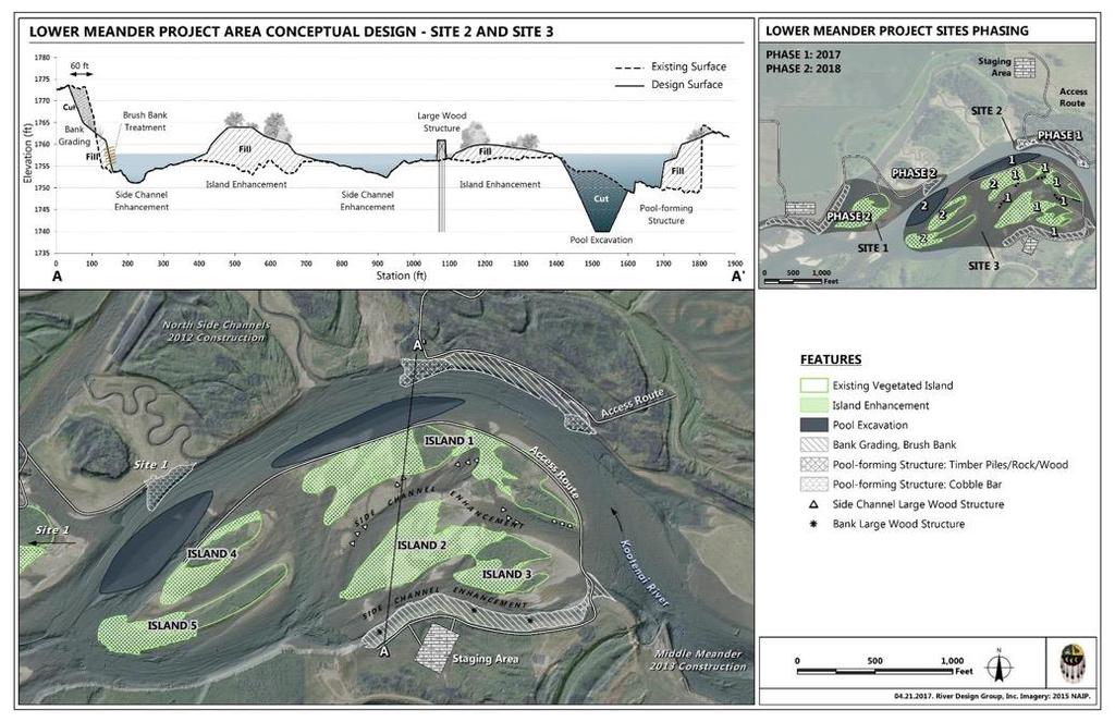
2 Kootenai River Habitat Restoration Program Multi-year habitat restoration program Restoration treatments designed to restore habitat and food web needed by Kootenai sturgeon and other native fish Individual projects work together to provide habitat attributes Compliments other efforts to restore fish and wildlife populations and their habitats + +


3 Master Plan Provides framework for large-scale restoration Emphasis on dynamic river processes and ecosystem functions not just one life stage of one species Synthesis of available data about river conditions Addresses limiting factors related to: Morphology Riparian Vegetation Aquatic Habitat River Management and stewardship Toolbox of restoration treatments to address unique limiting factors in each river reach
4 KRHRP Braided Reach Projects 2011 to 2017


5 Braided Reach Acres Restored Treatment Acres Floodplain grading and revegetation 55.9 Flow redirection structures 4.4 Island creation 20.2 Pool enhancement 5.3 Pool excavation 17.9 Reclamation seeding 52.7 Side channel realignment 2.3 Substrate enhancement 2.7 Photo: IDFG

6 Braided Reach Pool Ladder In 2017 saw more sturgeon moving upstream from Bonners Ferry Lower Meander Project 2018 pool will be last rung of Braided Reach pool ladder
 Increase riparian vegetation in the floodplain to contribute to the food web Increase habitat complexity and diversity")
7 Lower Meander Project Overview Biological objectives Add large deep pools for holding and staging habitat for sturgeon and burbot (add to pool ladder) Increase riparian vegetation in the floodplain to contribute to the food web Increase habitat complexity and diversity

8 Lower Meander Project Overview Actions Construct pool forming structures Excavate/enhance two deep pools Using excavated materials add fill and plantings to existing instream islands Construct vegetated brush bank structures Build wood structures in channels between islands

9 Lower Meander Project 2018 (Phase 2)
10

11 Lower Meander Project 2017 (Phase 1)


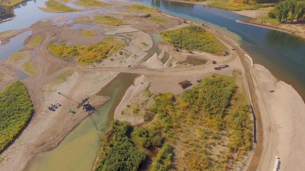
12 Lower Meander Pool Excavation 2017 August September (50,000 CY)
13

14 Lower Meander Site 1 (2018) Bank grading, wood structure, vegetated brush bank and revegetation Remove car bodies One poolforming structure


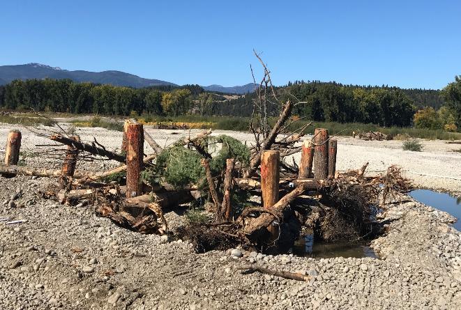
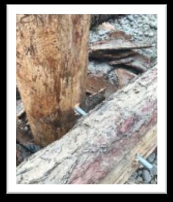
15 Site 1 - Bank Restoration and Island Enhancement Bank grading, 1 large wood structure, vegetated brush bank structures, and revegetation, along 1,900 ft long bank Example of vegetated brush bank construction from Lower Meander project Phase 1 (2017)

16 Bank Structure

17 Happy Willow Harvest Day! Oct 11, 2017


18 Site 1 - Bank Restoration and Island Enhancement Remove car bodies and other trash from bank
 Example of pool-forming structure construction from Lower Meander Phase 1")
19 Site 1 - Bank Restoration and Island Enhancement Construct one pool-forming structure (adjacent to the North Side Channels project completed in 2012) Example of pool-forming structure construction from Lower Meander Phase 1 (2017)


")

20 Examples of Lower Meander project Phase 1 (2017) pool forming structure construction.
")
21 Lower Meander Site 3 (2018)

22 Site 3 Pool creation and island enhancement Excavate one pool (about 4 acres in size and ft deep)
 in the river using material")
 Example of floodplain")
23 Site 3 Pool creation and island enhancement Construct and enhance an island on an existing bar (about 8 acres) in the river using material excavated from the pool Example of building access to island for construction (2017 Lower Meander project) Example of floodplain roughness


24 Site 3 Floodplain and Island Planting Planting, seeding and installation of browse protectors Floodplain and Island Planting


25 2018 Construction Schedule Overview July Mobilize for construction Grade and/or construct access roads (Site 1 and 3) Materials staging August Site 1 construction and car body removal North Side Channel adaptive management/maint enance work September Site 1 construction continued Site 3 construction October-November Floodplain roughness, plantings, seedings Re-establish access roads, remove materials and demobilize Site 1 and North Side Channels December Demobilization Site 3

26 Thank you! Questions?
STREAM BANK STABILIZATION THORPS MORTIMER RECREATION AREA Grandfather Ranger District SITE LOCATION & DRAINAGE AREA
 STREAM BANK STABILIZATION THORPS CREEK @ MORTIMER RECREATION AREA SITE LOCATION & DRAINAGE AREA SITE LOCATION Drainage Area = 1.14 sq. miles STREAM BANK STABILIZATION THORPS CREEK @ MORTIMER RECREATION
Tentatively Selected Plan within Harlem River, East River and Western Long Island Sound Planning Region. First Level Costs. Federal Non-Federal Total
 HARLEM RIVER, EAST RIVER AND WESTERN LONG ISLAND SOUND PLANNING REGION Flushing Bay and Creek Ecosystem Restoration Source Feasibility Study Background Study Resolution (1994), Reconnaissance Report (1996),
Arroyo Grande Creek Flood Control Channel Vegetation Management: A Photo Series
 Arroyo Grande Creek Flood Control Channel Vegetation Management: A Photo Series The Way It Was For several decades, all vegetation growth was discouraged in the AG Creek flood control channel, as shown
Balancing Conservation and Development on the Jordan River
 Balancing Conservation and Development on the Jordan River Jordan River Parkway Trail Regional Athletic Complex Conservation & Restoration Balancing Conservation and Development on the Jordan River Jordan
River Restoration Practices:
 River Restoration Practices: Comparison of British Columbia and Central European Practices by David Matsubara and Dave Murray Add Map of North America VANCOUVER, Wa. Add Map of Vancouver OUTLINE Introduction
Once Upon a Gravel Pit: Reconnecting Floodplain through Aggregate Extraction
 Once Upon a Gravel Pit: Reconnecting Floodplain through Aggregate Extraction 5 th International Conference on Natural Channel Systems September 26, 2016 1 The Story of Snyder s Flats Historical influences
Grave Creek Riparian Revegetation 2011 Implementation Report
 Task Order #1008 Grave Creek Riparian Revegetation 2011 Implementation Report Prepared for: Kootenai River Network P.O. Box 491 Libby, MT 59923 Prepared by: Geum Environmental Consulting, Inc. 307 State
FISH RESTORATION PROGRAM AGREEMENT Implementing Habitat Restoration Requirements Of The Biological Opinions
 FISH RESTORATION PROGRAM AGREEMENT Implementing Habitat Restoration Requirements Of The Biological Opinions Dennis McEwan Department of Water Resources waterways tidal wetlands Whipple et al. 2012: Sacramento-San
SECTION 5: REACH RECOMMENDATIONS/MAPS
 SECTION 5: REACH RECOMMENDATIONS/MAPS This section describes areas of concern and provides specific recommendations for each project reach. Locations of stormwater drains were from GIS coverage supplied
Meeting Agenda. City of Guelph. River Systems Advisory Committee. Agenda Items. Item 1, 2 and 3. Item 4 Ward to Downtown Pedestrian Bridge
 Meeting Agenda City of Guelph River Systems Advisory Committee September 19, 2018 City Hall, Meeting Room B From 4:00 to 6:00 p.m. Meeting Chair: Mariette Pushkar Agenda Items Welcome to all Item 1, 2
Stream Restoration: Working with Nature?
 Stream Restoration: Working with Nature? Greg Jennings, PhD, PE jenningsenv@gmail.com Ecosystem Restoration activities that initiate or accelerate the recovery of ecosystem health, integrity, and sustainability
Stream Restoration: Working with Nature? Greg Jennings, PhD, PE
 Stream Restoration: Working with Nature? Greg Jennings, PhD, PE jenningsenv@gmail.com Ecosystem Restoration activities that initiate or accelerate the recovery of ecosystem health, integrity, and sustainability
River Mile 10.9 Removal Action Overview
 River Mile 10.9 Removal Action Overview November 13, 2014 CAG Meeting Modified from CPG s RM10.9 Removal Action Final Design Report dated Nov. 2013 1 River Mile 10.9 Removal Action Activities Dredging:
How does the Program Work?
 Is your school interested in participating in a dynamic program that supports the development of a Schoolyard Habitat program at your school in association with a local National Wildlife Refuge? If so,
Is a Riparian Restoration Still Viable After 100-year Storm Events Alter the Original Design?
 Is a Riparian Restoration Still Viable After 100-year Storm Events Alter the Original Design? Sarah Spear Cooke, Ph.D. Seattle, Washington Presentation Outline Introduction The site pre-restoration Restoration
The use of willows in the rivers of the Bay of Plenty region, New Zealand
 The use of willows in the rivers of the Bay of Plenty region, New Zealand Presenters Tony Dunlop Principal Works Engineer Bay of Plenty Regional Council and Gary Williams, Waterscape Consultant Engineer
Planning for Staten. Habitat Restoration and Green Infrastructure. Island s North Shore
 Habitat Restoration and Green Infrastructure Planning for Staten Island s North Shore Community Board 1 March 1, 2018 NYC Parks Forestry, Horticulture, and Natural Resources Funded by the NYS Department
WETLAND SOD u Bare Root Wetland Plants u Deep Rooted Willows u Coir Logs u Native Trees & Shrubs u Habitat Islands u Custom Growing
 WETLAND SOD u Bare Root Wetland Plants u Deep Rooted Willows u Coir Logs u Native Trees & Shrubs u Habitat Islands u Custom Growing 2009 PROJECT HIGHLIGHTS The following 10 projects highlight the interesting
South Waterfront Park
 South Waterfront Park The South Waterfront Greenway Development Plan (GDP) has achieved an integrated and balanced design that fuses the goal of creating a new high-density urban community with the desire
Ecological Restoration at the Las Vegas Springs Preserve. Von K. Winkel, Ph.D.
 Ecological Restoration at the Las Vegas Springs Preserve Von K. Winkel, Ph.D. The Las Vegas Springs Before Disturbance The springs are very large. A small creek flows from each of 3 or 4 springs and
Baselands Trails Master Plan Public Meeting. April 28, 2015 Fire Academy, 895 Eastern Avenue, Toronto 6:30 p.m. to 9:00 p.m.
 Baselands Trails Master Plan Public Meeting April 28, 2015 Fire Academy, 895 Eastern Avenue, Toronto 6:30 p.m. to 9:00 p.m. Baselands Trails Master Plan Meeting Purpose To present and get feedback on:
New Brighton Park Shoreline Habitat Restoration Project
 Vancouver Board of Parks and Recreation and Port Metro Vancouver New Brighton Park Shoreline Habitat Restoration Project Conceptual Design Public Consultation August 26 September 9, 2015 Discussion Paper
Stormwater Standards. Clackamas County Service District No. 1. Planting Guide for Buffers
 Stormwater Standards Clackamas County Service District No. 1 APPENDIX B Planting Guide for Buffers Table of Contents Appendix B - Planting Guide for Buffers... Page B.1 General... 1 B.1.1 Introduction...
2011 ASLA Design Awards. Coyote Gulch Honor Award and Land Stewardship Designation Valerian LLC. Environmental Restoration and Reclamation
 2011 ASLA Design Awards Honor Award and Land Stewardship Designation Valerian LLC Environmental Restoration and Reclamation Project Name: Category : Project Location: 5 2011 Environmental Restoration and
PICTURE CANYON Planning Riparian-Wetland Refugia in an Urban Setting
 PICTURE CANYON Planning Riparian-Wetland Refugia in an Urban Setting Rio De Flag Existing Conditions. Ephemeral stream; Limited riparian plants, habitats.. & Opportunities Water (effluent) available Restore
Figure 1. Proposed Strategic Habitat Conservation Areas for Florida
 Figure 1. Proposed Strategic Habitat Conservation Areas for Florida Critical Lands and Waters Identification Project (CLIP) Cooperative Effort Century Commission for Sustainable Florida Florida Natural
Presentation to Parks and Open Space Advisory. Committee September 22, 2016
 Flood Planning & Preliminary Design Services for South St. Vrain Creek Restoration at Hall Ranch Presentation to Parks and Open Space Advisory Prepared for: Boulder County, Colorado Committee September
Glen Canyon National Recreation Area. Lees Ferry 10 Acre Riparian Revegetation Project
 Glen Canyon National Recreation Area Lees Ferry 10 Acre Riparian Revegetation Project Project Objectives Establish a 10 acre stand of native vegetation, including Freemont cottonwood, Gooddings willow
How to Update a Storm Water Management Program (SWMP) to Incorporate Total Maximum Daily Load (TMDL) BMPs
 to Incorporate Total Maximum Daily Load (TMDL) BMPs") How to Update a Storm Water Management Program (SWMP) to Incorporate Total Maximum Daily Load (TMDL) BMPs Janine Rybka Cuyahoga Soil & Water Conservation District About Habitat Habitats are the places
How to Update a Storm Water Management Program (SWMP) to Incorporate Total Maximum Daily Load (TMDL) BMPs Janine Rybka Cuyahoga Soil & Water Conservation District About Habitat Habitats are the places
Farmers Investment Co. (FICO) Continental Farms
 Continental Farms") Farmers Investment Co. (FICO) Continental Farms Planning & Zoning Commission Study Session (River Master Plan) January 25, 2012 FICO Property 7,000 acres total area 6,000 acres in Town of Sahuarita 1,000
Farmers Investment Co. (FICO) Continental Farms Planning & Zoning Commission Study Session (River Master Plan) January 25, 2012 FICO Property 7,000 acres total area 6,000 acres in Town of Sahuarita 1,000
Juneau Watershed Partnership
 Juneau Watershed Partnership Native Plant Resource Center Final Report A Partners for Fish and Wildlife Project Prepared for: U.S. Fish and Wildlife Service For Grant #F11C00552 Prepared by: The Juneau
ANDERSON RIVER PARK SIDE CHANNEL HABITAT RESTORATION PROJECT. Public Outreach Meeting June 5, 2017
 ANDERSON RIVER PARK SIDE CHANNEL HABITAT RESTORATION PROJECT Public Outreach Meeting June 5, 2017 Welcome and Introductions Providing Feedback Anderson River Park is an important part of the community
North Branch of Cypress Creek Ecological Restoration: A Comprehensive Approach to Stream Restoration
 North Branch of Cypress Creek Ecological Restoration: A Comprehensive Approach to Stream Restoration Rocky Powell Clear Creeks Consulting, LLC Keith D. Tate, P.E. BayLand Consultants & Designers, Inc.
DEVELOPMENT PERMIT SENSITIVE ECOSYSTEMS
 DEVELOPMENT PERMIT SENSITIVE ECOSYSTEMS What is the Sensitive Ecosystem Development Permit Area (SEDPA)? Surrey s SEDPA is made up of two distinct classifications of the natural environment: Streamside
Guiding Landowners in Stream Restoration. The Science, Practice & Art of Restoring Native Ecosystems 2015
 Guiding Landowners in Stream Restoration The Science, Practice & Art of Restoring Native Ecosystems 2015 January 24, 2015 Guiding Landowners in Stream Restoration January 24, 2015 Agenda 1Watershed Planning
Habitat Improvements to the Motor Island Shoreline in the Upper Niagara River, NY: A Collaborative Approach
 Habitat Improvements to the Motor Island Shoreline in the Upper Niagara River, NY: A Collaborative Approach Edward Alkiewicz 1, Stephen Schoenwiesner 1, Jeff Gerlach 1, Morris Perot 2, Scott Ault 2, Mark
A Field Guide to Common Aquatic Plants of Pennsylvania
 A Field Guide to Common Aquatic Plants of Pennsylvania College of Agricultural Sciences CONTENTS Introduction... 2 Algae... 8 Emergent... 20 Submerged... 48 Floating... 82 Index... 102 INTRODUCTION Pennsylvania
BASS PONDS, MARSH, & WETLAND HABITAT RESTORATION PROJECT
 FACT SHEET BASS PONDS, MARSH, & WETLAND HABITAT RESTORATION PROJECT MINNESOTA VALLEY NATIONAL WILDLIFE REFUGE, MINNESOTA ENVIRONMENTAL MANAGEMENT PROGRAM LOCATION Three areas located on the Minnesota Valley
Pat Rector, Environmental & Resource Management Agent Morris and Somerset Counties
 Morris County Presented to Bayer August 26, 2014 Pat Rector, Environmental & Resource Management Agent Morris and Somerset Counties rector@njaes.rutgers.edu Goal of the program Program Goal: The goal of
Introduction. Integrating Ecological Restoration of Estuarine Shorelines with Urban Community Revitalization Efforts. Ed Morgereth Biohabitats, Inc.
 Introduction Integrating Ecological Restoration of Estuarine Shorelines with Urban Community Revitalization Efforts Ed Morgereth Biohabitats, Inc. 5 th National Conference & Expo on Coastal and Estuarine
2011 ASLA Design Awards. Westside Creeks Restoration Plan Merit Award AECOM, Fort Collins. Planning & Urban Design
 2011 ASLA Design Awards Westside Creeks Restoration Plan Merit Award AECOM, Fort Collins Planning & Urban Design Project Fact Sheet Category of Entry: Rotating Specialty Award: 2011 2011 ASLA Colorado
The Napa River Flood Protection Project
 The Napa River Flood Protection Project Creating Flood Protection and Restoring Geomorphic and Biological Processes Jeremy Sarrow, Napa County Flood Control & Water Conservation District June 2, 2014.
BRUSH BOXES BIOENGINEERING TREATMENTS AND ROCK. Brush Boxes along the Rhine River in Germany. Brush Box on the Coeur d Alene River
 BIOENGINEERING TREATMENTS AND ROCK 3 BRUSH BOXES BRUSH BOX BREAKWATER Brush Boxes along the Rhine River in Germany. Brush Box on the Coeur d Alene River Built to protect the Phramities along the shoreline
Water for Nature Environmental Watering Site Monitoring Report by Dr Anne Jensen
 Water for Nature Environmental Watering Site Monitoring Report by Dr Anne Jensen Ramco River Terrace, South Australian Riverland July 2013 to June 2016 Nature Foundation SA is a not-for-profit nature charity
Shoreline Master Program Town of La Conner, Washington
 Shoreline Master Program Town of La Conner, Washington Department of Ecology approval effective Adopted September 24, 2013 by Town of La Conner Ordinance No.1106 Amended May 13, 2014 by Town of La Conner
las vegas wash coordination committee
 las vegas wash coordination committee lvwash.org DU Wetlands No. 1 Weir Planting Plan February 2013 DU Wetlands No. 1 Weir Planting Plan SOUTHERN NEVADA WATER AUTHORITY Las Vegas Wash Project Coordination
Lake and Stream Restoration Project
 Pre-project Fact Sheet May 2012 Toledo Botanical Garden (TBG) is a 60 acre public garden visited by more than 120,000 people annually. It is located in Toledo, Ohio in the Ottawa River watershed within
Community Conservation Workshop. Lake Placid
 Community Conservation Workshop Lake Placid 2 Community Conservation Program Welcome! We have designed a Community Conservation Program that listens to the needs of community members. We are conducting
Biotechnical streambank stabilization
 Traditional streambank stabilization Biotechnical streambank stabilization Channelization alters: shape pattern slope bed morphology cover Ecological effects: loss of riparian habitat loss of fish habitat
Don Narrows Workshop DRAFT MEETING REPORT Saturday, May 24, 2008 South Regent Park Recreation Centre
 Don Narrows Workshop DRAFT MEETING REPORT Saturday, May 24, 2008 South Regent Park Recreation Centre Introduction to the Workshop & this Report On Saturday, May 24, 2008 Toronto and Region Conservation
Town of Lyons Parks Flood Recovery Planning Process. Photograph courtesy of Ed Bruder
 Town of Lyons Parks Flood Recovery Planning Process Photograph courtesy of Ed Bruder Lyons Parks and Recreation Flood Recovery Update 1. Meadow Park Phase II - Project PW20B1 Estimated Completion: Summer
Virginia DCR- Natural Heritage Program. Tools for Linking Conservation and Transportation Planning
 Virginia DCR- Natural Heritage Program Tools for Linking Conservation and Transportation Planning November 9, 2009 MISSION: to conserve Virginia's biodiversity through statewide biological inventory, protection,
UNIVERSITY TOWN NEIGHBOURHOODS 5.2 ECO-CORRIDOR MELBOURNE CAMPUS MASTER PLAN 2014
 5.2 ECO-CORRIDOR 37 ECO-CORRIDOR EXISTING CONDITIONS & VISION NEIGHBOURHOOD VISION Investment in the Eco-corridor Neighbourhood will signify the University s commitment to supporting local ecology and
Colorado Watershed Protection Fund - Project Grant Application Fountain Creek Restoration Shryver Park Reach Including Shryver Pond
 Fountain Creek - Manitou Springs, CO Shryver Park Reach and Pond Restoration Project Submitted by: The Fountain Creek Restoration Committee & The Pikes Peak Community Foundation April 28, 2008 FCRC Page
Jill Stachura STORMWATER BMP AND STREAM RESTORATION IN A CITY PARK. October 2013 Southeast Stormwater Association Annual Conference, Charlotte, NC
 Jill Stachura STORMWATER BMP AND STREAM RESTORATION IN A CITY PARK October 2013 Southeast Stormwater Association Annual Conference, Charlotte, NC Project Location Gwinnett County, GA: Population: 825,000
LIFE RINASCE - Naturalistic Restoration for the integrated hydraulic-environmental Sustainability of the Emilian Canals LIFE13 ENV/IT/000169
 LIFE RINASCE - Naturalistic Restoration for the integrated hydraulic-environmental Sustainability of the Emilian Canals LIFE13 ENV/IT/000169 Project description Environmental issues Beneficiaries Administrative
Regional Restoration Planning:
 Regional Restoration Planning: A Case Study in Collaborative Restoration Science and Planning Campbell Ingram, Executive Officer NCER August 28, 2018 Co-Equal Responsibilities Act as a primary state agency
Town of Sahuarita Open Space Plan Element. University of Arizona Planning Program Projects Team
 Town of Sahuarita Open Space Plan Element University of Arizona Planning Program Projects Team Introduction Planning students in the Planning Program Project Class Overall Goal Potential uses of $1.5 Million
WILLAMETTE FALLS LEGACY PROJECT
 OPPORTUNITIES & CONSTRAINTS There are here three falls on a line of rocks extending across the river, which forms the bed of the upper channel. The water is precipitated through deep abrazed gorges, and
National Association of Conservation Districts. Kris Hoellen Vice President, Sustainable Programs The Conservation Fund September 19, 2013
 National Association of Conservation Districts Kris Hoellen Vice President, Sustainable Programs The Conservation Fund September 19, 2013 Our Mission The Conservation Fund forges partnerships to conserve
Caledon Villas Corp. c/o Mr. John Spina 55 Blue Willow Drive Woodbridge, ON L4L 9E8 May 14, Floodplain Characteristics, Old Church Road
 Caledon Villas Corp. c/o Mr. John Spina 55 Blue Willow Drive Woodbridge, ON L4L 9E8 May 14, 2013 Re: Floodplain Characteristics, Old Church Road This letter serves to confirm that I, Linda Sober, have
San Joaquin River Restoration Program Mendota Pool Bypass and Reach 2B Improvements Project. Restoration Goal Technical Feedback Group
 San Joaquin River Restoration Program Mendota Pool Bypass and Reach 2B Improvements Project Restoration Goal Technical Feedback Group March 20, 2014 1:30 pm San Luis and Delta-Mendota Water Authority 842
Natural Areas Certification Program Guidelines
 Natural Areas Certification Program Guidelines Purpose of the Program The City of Fort Collins Natural Areas Department encourages site management practices that focus on protecting, restoring, and enhancing
Best Management Practices
 Best Management Practices Urban Areas Aquatic Areas Natural Areas Best Management Practices Urban Areas Green Industry Best Management Practices Fertilizer Label Nitrogen Applications Phosphorous Applications
APPENDIX C NATURAL RESOURCES MANAGEMENT PLAN: ACTIONS AND PRIORITIES
 APPENDIX C NATURAL RESOURCES MANAGEMENT PLAN: ACTIONS AND PRIORITIES TABLE C-1: Resource Actions and Priorities GOAL NRM-4 Objective 4.1: Restore Natural floodplain functions. Objective 4.2: Define and
NATURAL LAKE & STREAMBANK PROTECTION & NATURAL BUFFERS. By Sam Martin, Water Management Specialist, Pine SWCD
 NATURAL LAKE & STREAMBANK PROTECTION & NATURAL BUFFERS By Sam Martin, Water Management Specialist, Pine SWCD Natural Lake & Streambank Protection & Natural Buffers Lakeshore & Streambank Erosion Projects
Big Thompson River Restoration Master Plan. Stakeholder Kick off Meeting and Workshop April 12, 2014
 Big Thompson River Restoration Master Plan Stakeholder Kick off Meeting and Workshop April 12, 2014 AGENDA 1:30 to 2:10 Information 2:10 to 2:35 Questions 245t 2:45 to 4:00 400 Worksession in Cafeteria
Community Conservation Workshop. Saranac River Basin Communities
 Community Conservation Workshop Saranac River Basin Communities 2 Community Conservation Program Welcome! We have designed a Community Conservation Program that listens to the needs of community members.
Lilburn, GA STORMWATER BMP AND STREAM RESTORATION IN A CITY PARK. July 2013 Jill Stachura
 Lilburn, GA STORMWATER BMP AND STREAM RESTORATION IN A CITY PARK July 2013 Jill Stachura Project Location Gwinnett County, GA: Population: 825,000 Area: 437 sq. miles 1,300 miles storm drainage system
Working with nature to manage your stream
 Working with nature to manage your stream Issued by Auckland Council March 2013 If you have any questions about this information sheet please contact Auckland Council on 09 301 0101 A stream in a property
GUIDELINES FOR ECOLOGICAL PERFORMANCE
 3 Landscape........................................... 3.2 Stormwater Management................................... 3.3 Hardscape........................................... 3.4 Streetscape..........................................
Peoria Riverfront Development (Ecosystem Restoration) Upper Mid-sized Island Critical Restoration Project (September 2011)
 Upper Mid-sized Island Critical Restoration Project (September 2011)") Peoria Riverfront Development (Ecosystem Restoration) Upper Mid-sized Island Critical Restoration Project (September 2011) Description The Corps of Engineers, Rock Island District (District) and the Illinois
Peoria Riverfront Development (Ecosystem Restoration) Upper Mid-sized Island Critical Restoration Project (September 2011) Description The Corps of Engineers, Rock Island District (District) and the Illinois
Phase 1 Habitat Replacement & Reconstruction
 Phase 1 Habitat Replacement & Reconstruction Marc Greenberg, USEPA greenberg.marc@epa.gov Hudson River EPA s Expectation of Habitat Reconstruction & Replacement provides diverse habitats Plants, plankton,
Restoring Soil Ecology and Native Plant Communities in an Altered Salt Pond Ecotone
 Restoring Soil Ecology and Native Plant Communities in an Altered Salt Pond Ecotone Dylan Chapple Save The Bay/UC Berkeley dylanchapple@berkeley.edu 10/24/2012 Overview Eden Landing Ecological Reserve
River Restoration in Urban Areas. Petra Podraza
 River Restoration in Urban Areas Petra Podraza 1 Rivers for the Life of Towns 2007 Main Problems in Urban Rivers water quality discharge volume (floods and peak flow condition) technical constructed river
Surface-Mining Land Reclamation Program KANSAS
 Surface-Mining Land Reclamation Program KANSAS Division of Conservation Responsibilities Administering Surface-Mining Land Conservation & Reclamation Act (SMLCRA) Surface Mining Land Conservation & Reclamation
Los Angeles River-Arroyo Seco Confluence Restoration Vision Plan. Professor Meredith McKenzie, JD Urban & Regional Planning Dept Cal Poly Pomona
 Los Angeles River-Arroyo Seco Confluence Restoration Vision Plan Professor Meredith McKenzie, JD Urban & Regional Planning Dept Cal Poly Pomona The Los Angeles River Watershed Arroyo Seco Watershed Map
Environmental Management Program
 Environmental Management Program St. Paul District MVP Reach Upper Impounded Reach 1- to 3-mile-wide valley Steep bluffs Extensive non-channel aquatic habitats Little floodplain development and few levees
One River Environmental Assessment. Welcome!
 One River Environmental Assessment Welcome! One River Environmental Assessment Welcome to the One River Environmental Assessment Public Information Centre. Please explore each presentation area to learn
Information for File MMJ Main Stem Bassett Creek Restoration Project
 Information for File 2013-03866-MMJ Main Stem Bassett Creek Restoration Project Applicant: Minneapolis Park and Recreation Board (MPRB) Corps Contact: Melissa Jenny Address: Corps of Engineers, St. Paul
The scope of the plan will focus on the Prospect Heights Slough and Hillcrest Lake as one entity.
 Plan for Prospect Heights Natural Resources Commission Plan for Improved Public Access and Enjoyment of the Prospect Heights Slough and Hillcrest Lake July 23, 2018 The City Council has requested the Natural
STEWARDSHIP OF LONG ISLAND SOUND S ECOLOGICAL AND RECREATIONAL RESOURCES
 STEWARDSHIP OF LONG ISLAND SOUND S ECOLOGICAL AND RECREATIONAL RESOURCES Robin Kriesberg, Save the Sound, Inc. Thomas Halavik, US Fish and Wildlife Service Coastal Program An Initiative to Identify, Protect
Restoring Floodplain Capacity and Hyporheic Function in an Urban Setting Thornton Confluence and Kingfisher Projects Mike (Rocky) Hrachovec, P.E.
 Hrachovec, P.E.") Restoring Floodplain Capacity and Hyporheic Function in an Urban Setting Thornton Confluence and Kingfisher Projects Mike (Rocky) Hrachovec, P.E. Project Locations: Historic Map of Thornton Creek orth
Restoring Floodplain Capacity and Hyporheic Function in an Urban Setting Thornton Confluence and Kingfisher Projects Mike (Rocky) Hrachovec, P.E. Project Locations: Historic Map of Thornton Creek orth
At the Heart of the Great Lakes
 Walpole Island Heritage Centre May 2010 At the Heart of the Great Lakes Bkejwanong: Where the Waters Divide Bkejwanong s Ecosystems OVERVIEW Walpole Island supports a rich mosaic of natural areas including
New techniques for urban river rehabilitation
 New techniques for urban river rehabilitation (WP8) URBEM Urban River Basin Enhancement Methods New techniques for urban river rehabilitation Methodology Work Package 8 LNEC João Rocha Elsa Alves EVK-CT-2002-00082
Department of Agriculture. Conservation Service. United States. Natural Resources REVISED 8/26/16
 GENERAL NOTES: SYMBOL LEGEND 1. All work shall comply with the constriction specifications, drawings, project-specific quality assurance plan and other contract requirements. 2. All notes on the drawings
Reconnecting rivers in urban areas; challenges and considerations
 River Forth Fisheries Trust Reconnecting rivers in urban areas; challenges and considerations RAFTS-ASFB conference 2016 Currently five morphology project sites in the Forth District with three informing
Terra Nova Rural Park Plan
 Terra Nova Rural Park Plan Part 1 Getting to know the land The Surrounding Area North Side Airport, River, Trail East Side - Residential West Side- Sturgeon Banks, West Dyke Trail South Side:Terra Nova
Wallkill River. Floodplain Bench Project Phase 1. OCSWCD Kevin Sumner. October 2016 Orange County. Wendell Buckman
 Wallkill River Floodplain Bench Project Phase 1 October 2016 Orange County OCSWCD Kevin Sumner Wendell Buckman Introduction Location Define the Problem History Location MIDDLETOWN NEWBURGH PROJECT Location
Design Considerations for Open Channel and Detention Pond Design. Howard Redfearn, City of Mansfield
 Design Considerations for Open Channel and Detention Pond Design Howard Redfearn, City of Mansfield Previous Experience/Criteria/Maintenance Issues New Criteria Discussion Overview Where is Mansfield?
5 TH ANNUAL CAPE COASTAL CONFERENCE COONAMESSETT RIVER RESTORATION PROJECT. Elizabeth H. Gladfelter, Ph.D. Conservation Commission Town of Falmouth
 5 TH ANNUAL CAPE COASTAL CONFERENCE COONAMESSETT RIVER RESTORATION PROJECT Elizabeth H. Gladfelter, Ph.D. Conservation Commission Town of Falmouth Mural by Teaticket Elementary School 2 nd graders, Spring
Restoration in the Sky Islands:
 Restoration in the Sky Islands: Bringing volunteers, landowners, practitioners and agencies together to benefit wildlife and habitats in a global biodiversity hotspot Sky Island Alliance Dedicated to the
Grand River Ravines Georgetown Township
 Grand River Ravines Georgetown Township Project Description: The Grand River Ravines County Park property is composed of the 68-acre former Fillmore at the Bend Open Space purchased in 1999 and two more
Bristol Marsh Heritage Conservancy
 Bristol Marsh Heritage Conservancy The Pennsylvania Environmental Council (PEC) protects and restores the natural and built environments through innovation, collaboration, education and advocacy. PEC believes
Conservation in South Jersey Being Creative with Restoration
 Conservation in South Jersey Being Creative with Restoration Stewardship on a Shoestring: Public Land Management in Fiscally Constrained Times November, 30, 2011 Conservation and Restoration for Open Space
Your town s subdivision or land use ordinance standards should reference the following street standards, for example:
 Your town s subdivision or land use ordinance standards should reference the following street standards, for example: Streets shall be designed to move traffic safely and in a way that minimizes environmental
IMPLEMENTATION STRATEGY: GOAL 1: TO SUSTAIN A HEALTHY NATIVE PRAIRIE GRAZING RESOURCE
 IMPLEMENTATION STRATEGY: GOAL 1: TO SUSTAIN A HEALTHY NATIVE PRAIRIE GRAZING RESOURCE Objectives Actions Timetable Lead and Supporting Agencies 1. Maintain or adopt sound rangeland practices that are reflective
Wisconsin NRCS Direct Volume Method Bank Recession Rate Categorizations
 2 Executive Summary The City of Ramsey contracted the Anoka Conservation District to complete an inventory of riverbank condition along the entire 5.8 miles of City that border the Mississippi River. The
Old Mill Community Association Bioretention Facility
 Project Overview This project will install a bioretention facility in a community recreation area owned by the Old Mill Community Association, Inc. Drainage from the area is currently unmanaged and has
Improving Communities Through the Arroyo Seco Sustainability Campaign and Watershed Assessment
 Improving Communities Through the Arroyo Seco Sustainability Campaign and Watershed Assessment Arroyo Seco Headwaters in the San Gabriel Mountains Major tributary to the Los Angeles River 44 square mile