las vegas wash coordination committee
|
|
|
- James King
- 5 years ago
- Views:
Transcription

1 las vegas wash coordination committee lvwash.org DU Wetlands No. 1 Weir Planting Plan February 2013
2 DU Wetlands No. 1 Weir Planting Plan SOUTHERN NEVADA WATER AUTHORITY Las Vegas Wash Project Coordination Team Prepared by: Jason R. Eckberg Southern Nevada Water Authority Las Vegas Wash Project Coordination Team 100 City Parkway, Suite 700 Las Vegas, Nevada February 2013
3 DU Wetlands No. 1 Weir Planting Plan Table of Contents Page No. Table of Contents... ii List of Tables... ii List of Figures... ii 1.0 PURPOSE AND GOALS OF THE PLANTING PLAN PROJECT SUMMARY Site Location Prior Conditions REVEGETATION DESIGN Emergent Wetland Planting Areas Non-Wetland Planting Areas Non-Wetland Planting Design PERMIT COMPLIANCE...7 List of Tables Table 1. DU Wetlands No. 1 Weir South revegetation species and quantity...7 List of Figures Figure 1. Location of the DU Wetlands No. 1 planting areas within the Clark County Wetlands Park...2 Figure 2. Location of DU Wetlands No. 1 Weir planting areas...3 Figure 3. Salinity contours across the DU Wetlands No. 1 South non-wetland planting site...4 Figure 4. Depth to water contours across the DU Wetlands No. 1 South non-wetland planting site...4 DU Wetlands No. 1 Weir Planting Plan ii
4 Page No. Figure 5. Emergent wetland planting areas at DU Wetlands No. 1 Weir...5 Figure 6. Non-wetland planting area at DU Wetlands No. 1 Weir...6 Figure 7. Non-wetland planting layout at DU Wetlands No. 1 Weir...8 DU Wetlands No. 1 Weir Planting Plan iii
5 1.0 PURPOSE AND GOALS OF THE PLANTING PLAN The purpose of this plan is to describe the revegetation strategies to be implemented at the DU Wetlands No. 1 Weir focusing primarily along the south side of the Las Vegas Wash (Wash). This site will provide additional erosion control and increase habitat for the diverse fauna found along the Wash. The general goals for this and other revegetation activities along the Wash are to develop ecologically functioning wetland, riparian, and upland areas that are self-sustaining in the long-term. Revegetation activities are coordinated by staff from the Southern Nevada Water Authority s (SNWA) Las Vegas Wash Project Coordination Team. Specific planning and strategies required to successfully revegetate the DU Wetlands No. 1 Weir site are described herein. This plan describes only the planting design for the wetland/emergent areas as well as the southern non-wetland area. The northern non-wetland area adjacent to the DU Wetlands No. 1 Weir will be used by contractors during the construction of additional erosion control structures in the future. A new planting plan including these areas will be drafted once the area is vacated by construction activities. 2.0 PROJECT SUMMARY 2.1 Site Location The DU Wetlands No. 1 Weir is located within the Clark County Wetlands Park (Figures 1 and 2). It is located along the lower Wash, approximately 1.2 miles downstream of the discharge of the Clark County Water Reclamation District. The project is located within the eastern half of Section 26 and western half of Section 25, Township 21 South, Range 22 East, MDB&M. APN and APN Prior Conditions Prior to construction, the footprint of the planting area was primarily dominated by salt cedar (Tamarix ramosissima) and common reed (Phragmites australis). Native vegetation documented on the site included quailbush (Atriplex lentiformis), arrowweed (Pluchea sericea), smartweed (Polygonum lapathifolium), southern cattail (Typha domingensis), and willow baccharis (Baccharis salicina). Wetland areas only had three species present; salt cedar, southern cattail, and common reed. 3.0 REVEGETATION DESIGN Plantings at the DU Wetlands No. 1 Weir will be divided into two separate planting schemes; non-wetland and wetland. Soil salinity and depth to water measurements were taken at locations throughout the non-wetland planting area (Figures 3 and 4). These measurements were used in the decision making process as to which particular plant species would be used in the planting design of the non-wetland planting areas. Both wetland and non-wetland plant design was heavily influenced on successful species establishment at the DU Wetlands No. 2 Weir located just upstream to the northwest of the site. Extending this planting scheme will result in a contiguous habitat which will benefit local wildlife and thereby improve overall ecosystem function. DU Wetlands No. 1 Weir Planting Plan 1

6 Figure 1: Location of the DU Wetlands No. 1 planting areas within the Clark County Wetlands Park. DU Wetlands No. 1 Planting Plan 2

7 Figure 2: Location of DU Wetlands No. 1 Weir planting areas. DU Wetlands No. 1 Planting Plan 3
8 Figure 3: Salinity contours across the DU Wetlands No. 1 South non-wetland planting site. Figure 4: Depth to water contours across the DU Wetlands No. 1 South non-wetland planting site. DU Wetlands No. 1 Planting Plan 4
. The majority of plantings will take place where the riprap bank protection meets the water s edge. These plantings will consist of transplanted emergent material and pole cuttings.")
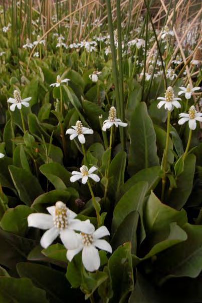
9 3.1 Emergent Wetland Planting Areas The emergent planting areas are located along the banks of the Wash on both the north and south side of the channel, as well as within the Wash channel itself (Figures 2 and 5). The majority of plantings will take place where the riprap bank protection meets the water s edge. These plantings will consist of transplanted emergent material and pole cuttings. Beginning in the winter of 2013, emergent plant material will be harvested from nearby locations along the Wash, as well as the Demonstration Wetland within the Henderson Bird Viewing Preserve. In regards to plantings within the Wash channel itself, the area depicted in Figure 2 is an approximation. Field crews doing the actual plantings will identify specific areas where sediment is substantial enough to hold the transplanted plants, therefore the final plant layout is more likely to be scattered throughout the channel rather than a rectangle; the total acreage planted is expected to be similar. A total of 1.34 acres of wetlands are planned. Wetland species harvested from the Wash and Demonstration Wetland and planted at DU1 Emergent (DU1E) areas are bulrush (Schoenoplectus acutus var. occidentalis), Olney threesquare (Schoenoplectus americanus), and California tule (Schoenoplectus californicus). The quantity of each species is subject to change due to abundance and availability of each species in the areas in which transplants will be taken. Pole plantings will exclusively come from established areas along the Wash. Species collected will include sandbar willow (Salix exigua), Goodding s willow (Salix gooddingii), Fremont s cottonwood (Populus fremontii), and seep willow (Baccharis salicifolia). Figure 5. Emergent wetland planting areas at DU Wetlands No. 1 Weir. DU Wetlands No. 1 Planting Plan 5
, four-wing saltbush (A. canescens), and alkali sacaton (Sporobolus airoides).")
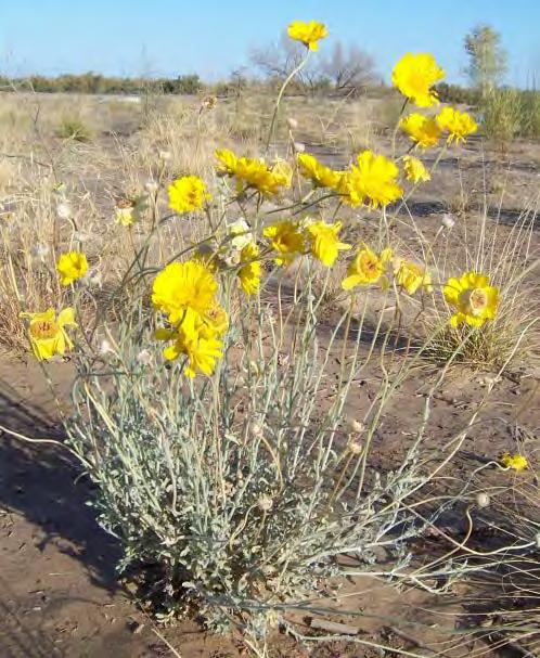
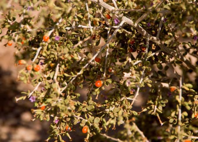
10 3.2 Non-Wetland Planting Areas As part of the construction requirements of the DU Wetlands No. 1 Weir, the non-wetland area was hydroseeded with native plant seeds. The species included in the hydroseed mix were desert saltbush (Atriplex polycarpa), four-wing saltbush (A. canescens), and alkali sacaton (Sporobolus airoides). Container plantings will compliment these hydroseeded species to enhance the restoration of the area. The planting is scheduled to take place as part of the Las Vegas Wash Coordination Committee s 22 nd semi-annual Green-Up event in the spring of The non-wetland planting area (Figures 2 and 6) has depth to water and salinity concentrations that will likely provide a good planting substrate for typical non-wetland plants that have been planted in previous plantings along the Wash. A mixture of honey mesquite (Prosopis glandulosa var. torreyana) and screwbean mesquite (Prosopis pubescens) will provide the largest component of the new plantings. In addition to these trees, a mixture of shrubs and grasses will help provide a diversity of plant types mimicking nearby natural areas: willow baccharis (Baccharis salicina), globemallow (Sphaeralcea ambigua), desert marigold (Baileya multiradiata), desert wolfberry (Lycium andersonii), and alkali sacaton. A total of 3000 individual plants will be planted: 800 mesquites and 2200 shrubs and grasses (Table 1). The non-wetland area is just over seven acres in size, resulting in approximately 427 plants per acre. Figure 6. Non- wetland planting area at DU Wetlands No. 1 Weir. Scientific name Common name Quantity DU Wetlands No. 1 Planting Plan 6
11 Baccharis salicina Willow baccharis 400 Baileya multiradiata Desert marigold 500 Lycium andersonii Wolfberry 400 Prosopis glandulosa var. torreyana Honey mesquite 400 Prosopis pubescens Screwbean mesquite 400 Sporobolus airoides Alkali sacaton 500 Sphaeralcea ambigua Globemallow 400 TOTAL 3000 Table 1. DU Wetlands No. 1 Weir South revegetation species and quantity Non-Wetland Planting Design The design of the non-wetland area was done to mimic natural establishment while acknowledging that the area is within a public park and will be visited by the public. Species will be generally grouped into areas commonly dominated by a single species, the exception being a large area with a mixture of smaller flowering shrubs (Figure 7). Where individual areas border each other, a transitional area will be created resulting in mixture of species from each adjoining area. Species locations were determined by the salinity and depth to water measurements (Figures 3 and 4). Specifically, alkali sacaton and both mesquites were placed in areas with the highest salinity. Depth to water did not have a significant impact on plant placement - only plant selection. 4.0 PERMIT COMPLIANCE A single 404 permit from the U.S. Army Corps of Engineers (Corps) was granted for the DU Wetlands No. 1 Weir. The wetlands mitigation requirement under this permit (SPK SG) is 1.22 acres. It is anticipated that the planting along the banks and within the Wash channel will be sufficient to meet this requirement. These wetland areas will be monitored to ensure they are meeting the criteria agreed upon between the Corps and SNWA in a letter dated July 15, Annual reports will be submitted to the Corps in regards to this project until all mitigation requirements have been met. The contractor responsible for the construction of the DU Wetlands No. 1 Weir was issued a stormwater permit by the Nevada Division of Environmental Protection. This permit covers areas on the north and south side of the channel for the DU Wetlands No. 1 Weir, as well as two other weirs built concurrently downstream of this site (Duck Creek Confluence and Upper Narrows). The revegetation requirement to close this permit is to establish vegetation at 70% of the pre-existing total cover. Detailed monitoring was not done prior to construction; however, aerial imagery shows that approximately 50% of the area had pre-existing vegetative cover. Assuming it was all native vegetation, the requirement would be to establish 35% cover. It is expected that the plant density at the time of planting will ensure permit closure in one growing season, as well as far exceeding this permit s requirements once plantings have taken place at all three weirs. DU Wetlands No. 1 Planting Plan 7

12 Figure 7. Non-Wetland planting layout at DU Wetlands No. 1 Weir. DU Wetlands No. 1 Planting Plan 8
Ecological Restoration at the Las Vegas Springs Preserve. Von K. Winkel, Ph.D.
 Ecological Restoration at the Las Vegas Springs Preserve Von K. Winkel, Ph.D. The Las Vegas Springs Before Disturbance The springs are very large. A small creek flows from each of 3 or 4 springs and
Melissa McMaster Restoration Coordinator
 Melissa McMaster Restoration Coordinator wildlife habitat specific threatened and endangered species habitat grazing shade recreation water storage fire risk reduction community stewardship ecosystem resiliency
Stormwater Standards. Clackamas County Service District No. 1. Planting Guide for Buffers
 Stormwater Standards Clackamas County Service District No. 1 APPENDIX B Planting Guide for Buffers Table of Contents Appendix B - Planting Guide for Buffers... Page B.1 General... 1 B.1.1 Introduction...
2011 ASLA Design Awards. Coyote Gulch Honor Award and Land Stewardship Designation Valerian LLC. Environmental Restoration and Reclamation
 2011 ASLA Design Awards Honor Award and Land Stewardship Designation Valerian LLC Environmental Restoration and Reclamation Project Name: Category : Project Location: 5 2011 Environmental Restoration and
WETLAND SOD u Bare Root Wetland Plants u Deep Rooted Willows u Coir Logs u Native Trees & Shrubs u Habitat Islands u Custom Growing
 WETLAND SOD u Bare Root Wetland Plants u Deep Rooted Willows u Coir Logs u Native Trees & Shrubs u Habitat Islands u Custom Growing 2009 PROJECT HIGHLIGHTS The following 10 projects highlight the interesting
Trestles Wetlands Natural Preserve Plant Communities. Plant Community Site Map from Feldmeth (1987):
:") Trestles Wetlands Natural Preserve Plant Communities Plant Community Site Map from Feldmeth (1987): In the definitive study Biological Resources of the San Mateo Creek Area (Feldmeth, 1987), the primary
Trestles Wetlands Natural Preserve Plant Communities Plant Community Site Map from Feldmeth (1987): In the definitive study Biological Resources of the San Mateo Creek Area (Feldmeth, 1987), the primary
Balancing Conservation and Development on the Jordan River
 Balancing Conservation and Development on the Jordan River Jordan River Parkway Trail Regional Athletic Complex Conservation & Restoration Balancing Conservation and Development on the Jordan River Jordan
Tentatively Selected Plan within Harlem River, East River and Western Long Island Sound Planning Region. First Level Costs. Federal Non-Federal Total
 HARLEM RIVER, EAST RIVER AND WESTERN LONG ISLAND SOUND PLANNING REGION Flushing Bay and Creek Ecosystem Restoration Source Feasibility Study Background Study Resolution (1994), Reconnaissance Report (1996),
Lake Nokomis Shoreline Enhancement Project
 Lake Nokomis Shoreline Enhancement Project Community Meeting 2 February 13, 2018 Agenda Current Problems Project Goals Project Status Existing Conditions Community Input Draft Schematic Design Long-term
Northern Branch Corridor SDEIS March 2017
 Northern Branch Corridor SDEIS March 2017 15. 15.1. Chapter Overview 15.1.1. Introduction This chapter discusses changes to the Preferred Alternative resulting in the potential for project improvements
Lake Ogallala Bathometric Project
 THE CENTRAL NEBRASKA PUBLIC POWER AND IRRIGATION DISTRICT Lake Ogallala Bathometric Project Mitigation Area Vegetation Monitoring Year 2 Mark Peyton 9/20/2012 Lake Ogallala Bathometric Project Mitigation
III. PROJECT DESCRIPTION
 III. PROJECT DESCRIPTION A. PROJECT LOCATION Regional Setting The project site is located in the southeast quadrant of the City of Chico in Butte County, California and is comprised of four parcels totaling
Section General Tree Preservation Requirements for New Nonresidential and Residential Development
 DIVISION 2: TREE PRESERVATION AND PROTECTION Section 5.5.2.1 General Tree Preservation Requirements for New Nonresidential and Residential Development (a) Application. The provisions of this Section apply
SITE INTRODUCTIONS AND OVERVIEW
 SITE INTRODUCTIONS AND OVERVIEW The City s formal Open Space Program was established in 1990 to implement long-standing policies that called for the protection of the farmlands and wild areas that surround
ADDENDUM TO BIOLOGICAL SCOPING SURVEY REPORT, BOTANICAL SURVEY AND WETLAND DELINEATION
 ADDENDUM TO BIOLOGICAL SCOPING SURVEY REPORT, BOTANICAL SURVEY AND WETLAND DELINEATION FOR AVALON INN (APN 069-241-27 & -04) 1201 & 1211 NORTH MAIN STREET FORT BRAGG, CA MENDOCINO COUNTY prepared for:
Kootenai River Habitat Restoration Program June 18, 2018 Kootenai Valley Resource Initiative Update
 Kootenai River Habitat Restoration Program June 18, 2018 Kootenai Valley Resource Initiative Update Kootenai River Habitat Restoration Program Multi-year habitat restoration program Restoration treatments
Presentation to Parks and Open Space Advisory. Committee September 22, 2016
 Flood Planning & Preliminary Design Services for South St. Vrain Creek Restoration at Hall Ranch Presentation to Parks and Open Space Advisory Prepared for: Boulder County, Colorado Committee September
Grave Creek Riparian Revegetation 2011 Implementation Report
 Task Order #1008 Grave Creek Riparian Revegetation 2011 Implementation Report Prepared for: Kootenai River Network P.O. Box 491 Libby, MT 59923 Prepared by: Geum Environmental Consulting, Inc. 307 State
Hunts Point Landing, Bronx, New York
 Hunts Point Landing, Bronx, New York Sustainable Shorelines in an Urban Environment John Roebig, PhD. HDR Engineering, Inc. John.Roebig@hdrinc.com Promoting Resilient Shorelines along the Hudson River
PICTURE CANYON Planning Riparian-Wetland Refugia in an Urban Setting
 PICTURE CANYON Planning Riparian-Wetland Refugia in an Urban Setting Rio De Flag Existing Conditions. Ephemeral stream; Limited riparian plants, habitats.. & Opportunities Water (effluent) available Restore
I611. Swanson North Precinct
 I611. Swanson North Precinct I611.1. Precinct Description Swanson North is located in the north eastern foothills of the Waitakere Ranges. It is outside the Waitakere Ranges Heritage Area Act and the Waitakere
Towne Park Estates Subdivision Phase II
 Towne Park Estates Subdivision Phase II ENVIRONMENTAL NARRATIVE October 21, 2014 Submitted to: Submitted by: Horner Environmental Professionals, Inc. 4252 Hay Road Lutz, Florida 33559 HEP TOWNE PARK ESTATES
Zoning Ordinance Article 3
 Article 3 Natural Resources Protection Section 301 Natural Resources Protection 301.1. Purpose - The following natural resources protection standards are established to protect the public health, safety
Glen Canyon National Recreation Area. Lees Ferry 10 Acre Riparian Revegetation Project
 Glen Canyon National Recreation Area Lees Ferry 10 Acre Riparian Revegetation Project Project Objectives Establish a 10 acre stand of native vegetation, including Freemont cottonwood, Gooddings willow
Planning for Staten. Habitat Restoration and Green Infrastructure. Island s North Shore
 Habitat Restoration and Green Infrastructure Planning for Staten Island s North Shore Community Board 1 March 1, 2018 NYC Parks Forestry, Horticulture, and Natural Resources Funded by the NYS Department
Juneau Watershed Partnership
 Juneau Watershed Partnership Native Plant Resource Center Final Report A Partners for Fish and Wildlife Project Prepared for: U.S. Fish and Wildlife Service For Grant #F11C00552 Prepared by: The Juneau
City of Waco Stormwater Management Regulations
 1.0 Applicability: City of Waco Stormwater Management Regulations These regulations apply to all development within the limits of the City of Waco as well as to any subdivisions within the extra territorial
2011 ASLA Design Awards. Westside Creeks Restoration Plan Merit Award AECOM, Fort Collins. Planning & Urban Design
 2011 ASLA Design Awards Westside Creeks Restoration Plan Merit Award AECOM, Fort Collins Planning & Urban Design Project Fact Sheet Category of Entry: Rotating Specialty Award: 2011 2011 ASLA Colorado
Final Report and Maintenance Requirements. Native Plant Screening for the New Wildlife Bridge at Catalina Catholic Church
 Final Report and Maintenance Requirements Native Plant Screening for the New Wildlife Bridge at Catalina Catholic Church 1 Introduction In this collaborative project, Pima County and the Santa Catalina
Response to Comments (July 28, 2010 Oregon City Determination of Application Completeness Memo)
") Environmental Science & Assessment, LLC MEMORANDUM DATE: August 13, 2010 TO: Oregon City Planning CC: Jill Long Lane Powell FROM: RE: Jack Dalton Response to Comments (July 28, 2010 Oregon City Determination
Environmental Science & Assessment, LLC MEMORANDUM DATE: August 13, 2010 TO: Oregon City Planning CC: Jill Long Lane Powell FROM: RE: Jack Dalton Response to Comments (July 28, 2010 Oregon City Determination
Post Construction BMPs
 Post Construction BMPs Why are Post Construction BMPs important? With increased development brings the increase of impervious cover Parking lots, rooftops, driveways Storm water runoff volume increases
Wisconsin Dept. of Transportation November 2017
 Wisconsin Dept. of Transportation November 2017 Jennifer Gibson WisDOT Environmental Coordinator Mike Helmrick WisDOT Environmental Coordinator Background on compensatory wetland mitigation Site purpose
NOTICE OF PREPARATION
 NOTICE OF PREPARATION DATE: January 6, 2016 TO: LEAD AGENCY: Responsible Agencies, Organizations, and Interested Parties Contact: Tyler Barrington, Principal Planner Planning Department Community Development
Banking on Natural Fibers Products made from coir and jute play a key role in stabilizing a restored stream for a commercial stream mitigation bank.
 Banking on Natural Fibers Products made from coir and jute play a key role in stabilizing a restored stream for a commercial stream mitigation bank. By Greg Northcutt When White Creek Mitigation, LLC,
Storm Water Quality and Shoreline Restoration Improvements - Grant Funding Request City of Mound Carlson Park Bolton & Menk Project No.
 September 15, 2016 Brett Eidem Cost Share Grant Administrator Minnehaha Creek Watershed District 15320 Minnetonka Boulevard Minnetonka, MN 55345 RE: Storm Water Quality and Shoreline Restoration Improvements
Call for Artists for: Design and Construction of Environmental Art Activation Story Mill Community Park, Bozeman, MT
 Call for Artists for: Design and Construction of Environmental Art Activation Story Mill Community Park, Bozeman, MT Seeking artists to design, fabricate and install art elements in the nature sanctuary
ALL SECURE SELF STORAGE SEPA APPEAL RECOMMENDATION TO THE HEARING EXAMINER
 KITSAP COUNTY DEPARTMENT OF COMMUNITY DEVELOPMENT 619 DIVISION STREET MS-36, PORT ORCHARD WASHINGTON 98366-4682 LOUISA GARBO, DIRECTOR (360) 337-5777 FAX (360) 337-4415 HOME PAGE - www.kitsapgov.com ALL
Section 3 Non-Structural BMPs
 3.1 Stream Buffers A stream buffer or stream setback is a designated area around a stream, lake, or wetland left in a natural, densely vegetated state so as to protect the receiving water quality and provide
Philbrook Avenue Wetlands and Stream Riparian Restoration Project Planting Plan 2009 REVISED AUGUST 24, 2009
 Philbrook Avenue Wetlands and Stream Riparian Restoration Project Planting Plan 2009 REVISED AUGUST 24, 2009 Submitted by Boyle Associates Per Request of Gorrill Palmer Consulting Engineers & the Cumberland
Limpia Creek Duck Pond. 25 acres, Jeff Davis County
 Limpia Creek Duck Pond 25 acres, Jeff Davis County Limpia Creek Duck Pond Hwy 17 N, 25 acres Jeff Davis County, Texas James Tammy King, Agent Broker Office King Land 432 & 426.2024 Water, LLC 432 426.2024
Hidden Pointe Landscape Master Plan. June, archi terra
 Hidden Pointe Landscape Master Plan June, 2006 t h e archi terra g r o u p 1 Table of Contents Background Purpose and Goals of the Master Plan Master Plan Process Existing Conditions Entrance Hidden Pointe
Conservation Plan. I. Property Information. II. Objectives. Natural Resource Objectives. Sustainability in Practice (SIP) Certified
 Certified") Conservation Plan Sustainability in Practice (SIP) Certified I. Property Information Vineyard Name and Establishment Date: Location: Map (attach showing blocks and acres): II. Objectives Natural Resource
Conservation Plan Sustainability in Practice (SIP) Certified I. Property Information Vineyard Name and Establishment Date: Location: Map (attach showing blocks and acres): II. Objectives Natural Resource
3.10 LAND USE SETTING PROJECT SITE EXISTING LAND USE DESIGNATIONS AND ZONING. General Plan Land Use Designations.
 This section of the Draft EIR addresses the existing land uses on and adjacent to the project site and discusses the potential impacts of the proposed project on existing land uses. Key issues addressed
Surface Coal Mining and Reclamation in ND. Guy Welch ND Public Service Commission
 Surface Coal Mining and Reclamation in ND Guy Welch ND Public Service Commission Surface Coal Mines in North Dakota Approximately 1500 acres are disturbed each year History of Reclamation in ND First surface
Is a Riparian Restoration Still Viable After 100-year Storm Events Alter the Original Design?
 Is a Riparian Restoration Still Viable After 100-year Storm Events Alter the Original Design? Sarah Spear Cooke, Ph.D. Seattle, Washington Presentation Outline Introduction The site pre-restoration Restoration
Wisconsin NRCS Direct Volume Method Bank Recession Rate Categorizations
 2 Executive Summary The City of Ramsey contracted the Anoka Conservation District to complete an inventory of riverbank condition along the entire 5.8 miles of City that border the Mississippi River. The
EPA Surface Water Enhancement, Restoration & Protection (SWERP)
") EPA Surface Water Enhancement, Restoration & Protection (SWERP) Clearinghouse Application Form 4.0004 wirerp"776- )11644141' For assistance with completing this form, please refer to the SWERP Clearinghouse
EPA Surface Water Enhancement, Restoration & Protection (SWERP) Clearinghouse Application Form 4.0004 wirerp"776- )11644141' For assistance with completing this form, please refer to the SWERP Clearinghouse
15. Wetlands Chapter Overview Introduction
 15. Wetlands 15.1. Chapter Overview 15.1.1. Introduction Pursuant to Presidential Executive Order 11990 entitled Protection of Wetlands, the United States Department of Transportation (USDOT) developed
Merkel & Associates, Inc Ruffin Road, San Diego, CA Tel: 858/ Fax: 858/
 Merkel & Associates, Inc. 5434 Ruffin Road, San Diego, CA 92123 Tel: 858/560-5465 Fax: 858/560-7779 e-mail: associates@merkelinc.com February 23, 2009 M&A # 08-021-02 Ms. Staci Merriman Metropolitan Wastewater
Rockwell Collins Green Communities Grant Application
 Rockwell Collins Green Communities Grant Application Contact Information Legal Name of Organization Applying for Funding: Indian Creek Nature Center (should be the same as on IRS determination letter and
OPERATIONS & MAINTENANCE MANUAL FOR POST CONSTRUCTION MEASURES
 OPERATIONS & MAINTENANCE MANUAL FOR POST CONSTRUCTION MEASURES THE CARMONY BUILDING PARAGON REALTY NORTH GREEN STREET BROWNSBURG, HENDRICKS COUNTY INDIANA 8365 Keystone Crossing, Suite 201 Indianapolis,
PURPOSE: The purpose is to provide commercial facilities in the Vancouver and Clark County vicinity.
 US Army Corps of Engineers Seattle District Joint Public Notice Application for a Department of the Army Permit and a Washington Department of Ecology Water Quality Certification and/or Coastal Zone Management
Dolores River Restoration Partnership. A Collaborative Approach to River Restoration and the Development of a New Generation of Land Stewards
 Dolores River Restoration Partnership Dolores Public Lands A Collaborative Approach to River Restoration and the Development of a New Generation of Land Stewards Project Area From McPhee Reservoir to the
Restoration of Riparian Buffer at the Former Smelt Hill Dam Site, Falmouth, Maine
 Restoration of Riparian Buffer at the Former Smelt Hill Dam Site, Falmouth, Maine Final Report June 30, 2006 Page 1 of 16 I. Project Title Restoration of Riparian Buffer at the Former Smelt Hill Dam Site,
C ity of Grande Prairie Development Services Department
 C ity of Grande Prairie Development Services Department FAIRWAY DEVELOPMENT OUTLINE PLAN OP 08 09 Approved April 6, 2009 Prepared by: Focus Corporation Table of Contents 1.0. Introduction 2 3 1.1. Plan
Property. Line. Fence. Plantings. Vegetated Buttress. With Sun Tolerant. Vegetated Terrace. Tolerant Plantings Existing
 PREFERRED ALTERNATIVE - CROSS SECTIONS 92 Existing Pool Property Line 2 6 10 14 0 4 8 12 16 Existing Armour Stone Wall Existing Proposed 18 22 20 24 26 30 28 32 34 36 38 Property Line 40 44 48 52 56 42
Commercial Launch Site Addendum to Wetland Mitigation Plan. Revision 2. April 25, SpaceX Proprietary
 Commercial Launch Site Addendum to Wetland Mitigation Plan Revision 2 April 25, 2017 SpaceX Proprietary Contents 1.0 Project Information... 1 1.1 Background... 1 2.0 Compensatory Mitigation... 2 2.1 Goals
Chagrin River Watershed Partners, Inc. Local Regulations. Amy H. Brennan (440)
") Chagrin River Watershed Partners, Inc. Local Regulations Amy H. Brennan (440) 975-3870 www.crwp.org abrennan@crwp.org July 9, 2013 Applicable Zoning and Building Codes Erosion and Sediment Control Grading
Chagrin River Watershed Partners, Inc. Local Regulations Amy H. Brennan (440) 975-3870 www.crwp.org abrennan@crwp.org July 9, 2013 Applicable Zoning and Building Codes Erosion and Sediment Control Grading
SECTION 5: REACH RECOMMENDATIONS/MAPS
 SECTION 5: REACH RECOMMENDATIONS/MAPS This section describes areas of concern and provides specific recommendations for each project reach. Locations of stormwater drains were from GIS coverage supplied
2. IF CHANGES ARE TO BE MADE TO SEED MIX BASED ON SITE CONDITIONS THEN APPROVAL MUST BE PROVIDED BY CITY ENVIRONMENTAL PLANNER.
 CITY OF FORT COLLINS NATIVE SEED MIX NOTES 1. PREPARE SOIL AS NECESSARY AND APPROPRIATE FOR NATIVE SEED MIX SPECIES THROUGH AERATION AND ADDITION OF AMENDMENTS, THEN SEED IN TWO DIRECTIONS TO DISTRIBUTE
Pittsburgh District Pittsburgh, PA Notice No Closing Date: May 29, 2015
 Public Notice U.S. Army Corps In Reply Refer to US Army Corps of Engineers, Pittsburgh District of Engineers Notice No. below 1000 Liberty Avenue Pittsburgh District Pittsburgh, PA 15222-4186 Application
Department of Community Development. Planning and Environmental Review Division Revised Notice of Preparation
 Department of Community Development Michael J. Penrose, Acting Director Divisions Building Permits & Inspection Code Enforcement County Engineering Economic Development & Marketing Planning & Environmental
Pike River Restoration Adaptive Design: Restoring Structure and Function in an Urban Floodplain - from cabbages to cordgrass
 Pike River Restoration Adaptive Design: Restoring Structure and Function in an Urban Floodplain - from cabbages to cordgrass Alice Thompson, PWS & Heather Patti, PWS Pike River Re-imaginedfrom Cabbage
BASS PONDS, MARSH, & WETLAND HABITAT RESTORATION PROJECT
 FACT SHEET BASS PONDS, MARSH, & WETLAND HABITAT RESTORATION PROJECT MINNESOTA VALLEY NATIONAL WILDLIFE REFUGE, MINNESOTA ENVIRONMENTAL MANAGEMENT PROGRAM LOCATION Three areas located on the Minnesota Valley
Josephine County, Oregon Board of Commissioners: Jim Riddle, Dwight F. Ellis, & Jim Raffenburg
 Josephine County, Oregon Board of Commissioners: Jim Riddle, Dwight F. Ellis, & Jim Raffenburg PLANNING OFFICE Michael Snider, Director 510 NW 4 th Street / Grants Pass, OR 97526 (541) 474-5421 / FAX (541)
APPENDIX P MASTER STREETS AND HIGHWAYS PLAN ACCESS2040 APPENDIX P (MASTER STREETS AND HIGHWAYS PLAN)
") APPENDIX P MASTER STREETS AND HIGHWAYS PLAN ACCESS2040 APPENDIX P (MASTER STREETS AND HIGHWAYS PLAN) Introduction This element of the Access2040 Regional Transportation Plan provides the Southern Nevada
APPENDIX P MASTER STREETS AND HIGHWAYS PLAN ACCESS2040 APPENDIX P (MASTER STREETS AND HIGHWAYS PLAN) Introduction This element of the Access2040 Regional Transportation Plan provides the Southern Nevada
STAFF REPORT FOR STANDARD COASTAL DEVELOPMENT PERMIT #CDP FEBRUARY 26, 2015 CPA - 1 PO BOX 238 APTOS, CA 94001
 STAFF REPORT FOR STANDARD COASTAL DEVELOPMENT PERMIT #CDP 2014-0030 FEBRUARY 26, 2015 CPA - 1 OWNER/APPLICANT: AGENT: REQUEST: HANS HEIM PO BOX 238 APTOS, CA 94001 JAMES HAY PO BOX 762 MENDOCINO, CA 95460
Understanding Drainage Options What s Feasible and Legal. February 2019
 Understanding Drainage Options What s Feasible and Legal February 2019 Outline for the Presentation Do you need a permit? Does common law apply? Does local government approve it? Will my neighbor allow
Soil Reclamation and Site Reinstatement
 APPENDIX 6 Soil Reclamation and Site Reinstatement Purpose To undertake soil reclamation, erosion protection, Site restoration and reinstatement, taking into account natural processes, operational requirements
Holland Country Club Golf Course to Wetlands
 Holland Country Club Golf Course to Wetlands John Scholtz, Director Ottawa County Parks & Recreation Commission Amy A. Berry, Project Manager Niswander Environmental, LLC OTTAWA COUNTY PARKS: Focusing
Pick your battles Eliminating weedy cottonwood is a fight worth taking on
 Pick your battles Eliminating weedy cottonwood is a fight worth taking on Cottonwoods, also known as poplars, are regionally abundant native trees that can become weedy in container and field nurseries.
Habitat Improvements to the Motor Island Shoreline in the Upper Niagara River, NY: A Collaborative Approach
 Habitat Improvements to the Motor Island Shoreline in the Upper Niagara River, NY: A Collaborative Approach Edward Alkiewicz 1, Stephen Schoenwiesner 1, Jeff Gerlach 1, Morris Perot 2, Scott Ault 2, Mark
4.6. Low Impact and Retentive Grading
 4.6. Low Impact and Retentive Grading Low Impact Grading techniques focus on utilizing existing topography during Site layout to minimize cost. Proposing structures, roads, and other impervious surfaces
Wetland Types. Grade Level: Basic. Duration: 30 minutes. Setting: Classroom
 Wetland Types Adapted from: An original Creek Connections activity created by Cassandra Hamilton. Creek Connections, Box E, Allegheny College, Meadville, PA 16335 http://creekconnections.allegheny.edu
Information for File MMJ Main Stem Bassett Creek Restoration Project
 Information for File 2013-03866-MMJ Main Stem Bassett Creek Restoration Project Applicant: Minneapolis Park and Recreation Board (MPRB) Corps Contact: Melissa Jenny Address: Corps of Engineers, St. Paul
Virginia DCR- Natural Heritage Program. Tools for Linking Conservation and Transportation Planning
 Virginia DCR- Natural Heritage Program Tools for Linking Conservation and Transportation Planning November 9, 2009 MISSION: to conserve Virginia's biodiversity through statewide biological inventory, protection,
LICENSES FOR UTILITY CROSSINGS OF PUBLIC LANDS AND WATERS ACCORDING TO MINNESOTA RULES CHAPTER [Rules Effective July 1, 2004]
![LICENSES FOR UTILITY CROSSINGS OF PUBLIC LANDS AND WATERS ACCORDING TO MINNESOTA RULES CHAPTER [Rules Effective July 1, 2004]](/thumbs/78/77546780.jpg "LICENSES FOR UTILITY CROSSINGS OF PUBLIC LANDS AND WATERS ACCORDING TO MINNESOTA RULES CHAPTER [Rules Effective July 1, 2004]") LICENSES FOR UTILITY CROSSINGS OF PUBLIC LANDS AND WATERS ACCORDING TO MINNESOTA RULES CHAPTER 6135 [Rules Effective July 1, 2004] Minnesota Department of Natural Resources Division of Lands and Minerals
LICENSES FOR UTILITY CROSSINGS OF PUBLIC LANDS AND WATERS ACCORDING TO MINNESOTA RULES CHAPTER 6135 [Rules Effective July 1, 2004] Minnesota Department of Natural Resources Division of Lands and Minerals
Environmental Protection Ordinances (Performance Zoning) Bedminster Township, Bucks County
 Bedminster Township, Bucks County") Environmental Protection Ordinances (Performance Zoning) Bedminster Township, Bucks County ARTICLE VI. PERFORMANCE STANDARDS Section 600 Compliance All uses, activities, subdivisions and/or land developments
Environmental Protection Ordinances (Performance Zoning) Bedminster Township, Bucks County ARTICLE VI. PERFORMANCE STANDARDS Section 600 Compliance All uses, activities, subdivisions and/or land developments
Clerk of the Board of Supervisors. Date: May 20, Parkmerced Design Standards + Guidelines
 To: From: Clerk of the Board of Supervisors MOEWD Date: May 0, 0 Re: Parkmerced Design Standards + Guidelines In connection with the Parkmerced Project, the project sponsor has previously submitted to
7. Biodiversity & Conservation Areas
 7. & Conservation Areas 7.1. Objectives The objectives of biodiversity and conservation areas are founded on the need to recognise the importance of biodiversity and acknowledge the need to protect, restore
Recent Tidal Creek Restoration Efforts in Tampa Bay
 Recent Tidal Creek Restoration Efforts in Tampa Bay Ed Sherwood Tampa Bay Estuary Program Co-Authors: Brandt Henningsen, SWFWMD, SWIM Overview Tampa Bay Watershed & Tidal Creek Overview Habitat Restoration
RESPONSES TO PUBLIC CONCERNS AND QUESTIONS
 RESPONSES TO PUBLIC CONCERNS AND QUESTIONS Stations and Summary Questions for Public Meeting #2 June 23, 2015 General Questions / Concerns: 1. Is there any way this development can raise revenue for the
5/18/2012. Valley Woods wetlands before. Rouge Park prairie before
 GLRI Grant Transforming the Rouge from Mowed Down to Grown Up Controlled Burns at: Valley Woods Nature Preserve, Southfield River Rouge Park and Eliza Howell Park, Detroit Why Do Controlled Burn? Maintain
The Restoration of Reading Creek & Model Stream Buffer Ordinances/ Zoning Regulations for Alabama Streams
 The Restoration of Reading Creek & Model Stream Buffer Ordinances/ Zoning Regulations for Alabama Streams Charlene LeBleu, AICP, ASLA, Associate Professor of Landscape Architecture Auburn University Auburn,
Town of Vershire Road Erosion Inventory Report
 Town of Vershire Road Erosion Inventory Report Taylor Valley Road. Photo taken by TRORC staff. Prepared by: 128 King Farm Road Woodstock, VT 05091 Inventory and report funded by the Vermont Agency of Transportation
ADOPTED CAPITAL IMPROVEMENT PROGRAM BUDGET ARROYO PROJECTS
 ADOPTED CAPITAL IMPROVEMENT PROGRAM BUDGET ARROYO PROJECTS HAHAMONGNA FY 212-216 Capital Improvement Program Priority Description Total Estimated Costs Appropriated Through FY 211 Adopted FY 212 FY 213
CITY OF TUCSON DEVELOPMENT STANDARD NO FLOODPLAIN, WASH AND ENVIRONMENTAL RESOURCE ZONE (ERZ) STANDARD
 STANDARD") FLOODPLAIN, WASH AND ENVIRONMENTAL RESOURCE ZONE (ERZ) STANDARD 9-06.1.0 GENERAL 9-06.2.0 DEVELOPMENT REGULATIONS 9-06.3.0 REVIEW 9-06.4.0 PRA PLAN SUBMITTAL REQUIREMENTS 9-06.5.0 MODIFICATIONS 9-06.0.0.
FLOODPLAIN, WASH AND ENVIRONMENTAL RESOURCE ZONE (ERZ) STANDARD 9-06.1.0 GENERAL 9-06.2.0 DEVELOPMENT REGULATIONS 9-06.3.0 REVIEW 9-06.4.0 PRA PLAN SUBMITTAL REQUIREMENTS 9-06.5.0 MODIFICATIONS 9-06.0.0.
STREAM ALTERATION PRACTICES
 STREAM ALTERATION PRACTICES Stream Diversion Channel SDC DEFINITION A temporary channel constructed to convey stream flow around in-stream construction. PURPOSE Stream diversion channels are used to allow
Non-Metallic Mining Reclamation Checklist
 Eau Claire County DEPARTMENT OF PLANNING AND DEVELOPMENT Eau Claire County Courthouse, Rm. 1510 721 Oxford Avenue Eau Claire, Wisconsin 54703-5481 (715) 839-4741 f Housing & Community Development 839-6240
Yuma East Wetlands Restoration Project. Restoring a Forgotten Landscape on the Lower Colorado
 Yuma East Wetlands Restoration Project Restoring a Forgotten Landscape on the Lower Colorado A challenged river system The Lower Colorado River used to support more than 450,000 acres of native forests
MITIGATION MANAGEMENT AND MONITORING PLAN BAYFRONT PARK WETLAND RESTORATION MILL VALLEY, CA
 MITIGATION MANAGEMENT AND MONITORING PLAN BAYFRONT PARK WETLAND RESTORATION MILL VALLEY, CA PREPARED FOR: THE CITY OF MILL VALLEY PARKS AND RECREATION DEPARTMENT 180 CAMINO ALTO AVENUE MILL VALLEY, CA
Gamble s Quail Callipepla gambelii. Part Five Recommended Actions
 Gamble s Quail Callipepla gambelii Part Five Recommended Actions 28 Recommendation 1: Compile past and present data for the park and, as data are collected, create a geographic information system (GIS)
Verde Valley Landscape Character Type
 Existing Condition Landscape Character The existing landscape character describes the existing set of valued aesthetic attributes for the current landscape. The landscape character descriptions include
Table of Contents G.1.a Water Resources - Surface Water - Drainage
 Table of Contents G.1.a Water Resources - Surface Water - Drainage 1. INTRODUCTION... 1335 2. ENVIRONMENTAL SETTING... 1335 a. Regional Hydrology... 1335 b. Local Hydrology... 1337 c. On-site Hydrology...
Draft Rhode Island Stormwater Design and Installation Standards Manual
 Draft Rhode Island Stormwater Design and Installation Standards Manual Summary The May 2009 Public Review Draft version of the RI Stormwater Design and Installation Standards Manual consists of approximately
Table of Contents TABLE OF CONTENTS SECTION TITLE PAGE
 TABLE OF CONTENTS SECTION TITLE PAGE 1 INTRODUCTION AND OVERVIEW 1-1 1.1 Purpose and Need 1-1 1.2 Goals and Objectives 1-3 1.3 Overview of the Planning Process 1-5 1.4 Federal and State Requirements and
Old Brick Township DRI Recommendation Report
 Old Brick Township DRI Recommendation Report City of Palm Coast Presented to NEFRC Planning and Growth Management; Board of Directors July 8, 2010 Recommendation #1 Conversion table limited by transportation
Pedestrian Trails Within Regulated Areas
 New Jersey Department of Environmental Protection Pedestrian Trails Within Regulated Areas Joslin Tamagno, Environmental Specialist Division of Land Use Regulation, Bureau of Inland Regulation www.nj.gov/dep/landuse
The scope of the plan will focus on the Prospect Heights Slough and Hillcrest Lake as one entity.
 Plan for Prospect Heights Natural Resources Commission Plan for Improved Public Access and Enjoyment of the Prospect Heights Slough and Hillcrest Lake July 23, 2018 The City Council has requested the Natural
Minnesota Department of Natural Resource - Natural Resource Guidance Checklist Conserving Natural Resources through Density Bonuses
 Minnesota Department of Natural Resource - Natural Resource Guidance Checklist Conserving Natural Resources through Density Bonuses NRDB Why Use Density Bonuses & This Checklist Local units of government