Restoration of Riparian Buffer at the Former Smelt Hill Dam Site, Falmouth, Maine
|
|
|
- Melvyn Sullivan
- 5 years ago
- Views:
Transcription


1 Restoration of Riparian Buffer at the Former Smelt Hill Dam Site, Falmouth, Maine Final Report June 30, 2006 Page 1 of 16
2 I. Project Title Restoration of Riparian Buffer at the Former Smelt Hill Dam Site, Falmouth, Maine II. Reporting Period: 06/01/05 6/01/06 III. Project Narrative Problems Addressed: This project addressed several problems at the Smelt Hill Dam removal site, including a lack of forested riparian buffer, erosion and sediment deposition into the Presumpscot River caused in part by the flow of stormwater through the site, and the presence of invasive species. Lack of forested buffer: Large angular riprap and crushed stone were deposited in the riparian buffer as part of the Smelt Hill Dam removal project completed by the US Army Corps of Engineers in 2002, presumably in order to ensure bank stability and to cover deposited coarse debris from the dam and appurtenant structures. Fine textured soils were completely absent from the mid and lower sections of the buffer except for some thin deposits near the normal high water mark, where fines had recently been deposited in the interstices of riprap and along the shoreline. Prior to project implementation, the upper portion of the riparian buffer consisted of a small area of herbaceous vegetation over sandy soil that graded smoothly into upland forest about 200 feet from the normal high water line of the river. Presence of invasive species: Those areas that did have small deposits of fine-textured alluvium near the shoreline had an early-successional emergent plant community. This shoreline community consisted of several native riparian and wetland species typical in southern Maine. Two exotic/invasive species of concern were also observed: purple loosestrife (Lythrum salicaria) and white sweet clover (Melilotus alba). Away from the shoreline, in the middle and upper portions of the buffer, additional species were observed including Japanese knotweed (Falopia japonica), which is another exotic/invasive species of concern. Native vegetation was needed to compete with invasives, protect and stabilize healthy riparian buffers upstream and downstream of the site, and provide a contiguous vegetated buffer to function as a wildlife corridor along the river shoreline. Address stormwater runoff & erosion: There was also a need to improve stormwater runoff at the site. Prior to project implementation, stormwater runoff had created a deepening and widening gully during significant rain events. A significant headcut had formed and was migrating up the slope. Most of the stormwater appeared to be coming from an existing catch basin and culvert outlet, rather than the road itself. A small, crushed rock trail leading down from one house lot may have exacerbated the erosion by channelizing the stormflow and not allowing it to spread out through the woods. The gully downstream of the culvert outlet but upstream of the project site showed signs of recent erosion, with the channel widening and eroding down to boulder or bedrock material and resulting in sediment deposition into the Presumpscot River. The storm flow exited the woods at the access road and then ran in the eroded gully down across the riprap slope. The upper riprap (crushed rock) had slumped in a few areas due to the runoff over the slope. The site is the property of the Maine Department of Marine Resources (DMR). Project objectives and goals: The overall project objective was to restore a native vegetated riparian buffer at the highly visible site of the 2002 Smelt Hill Dam removal, where the natural shoreline was covered with riprap and gravel. Another objective of the project was to reduce erosion due to stormwater runoff at the site. Given that much of the Presumpscot River is dammed, and that head of tide areas are Page 2 of 16
3 important habitat in coastal rivers, a contiguous vegetated buffer and associated detrital inputs provide high value habitat in even in this short stretch of unimpounded river. Specific project objectives were to: 1. Create a stable runoff drainage channel and repair and stabilize slumping areas. 2. Create a simple pond/wetland area to slow runoff, distribute a sheet flow of water, allow some settling of sediment, and absorb pollutants. 3. Increase vegetative cover along the unimpounded section of the river and increase the structural and floristic diversity of the entire site. 4. Eradicate invasive plants at the site and establish native vegetative cover. 5. Create a more visually appealing riparian strip. Project description: The Casco Bay Estuary Partnership (CBEP) was awarded a grant from the Gulf of Maine Council to restore approximately 250 feet of riparian buffer habitat at the site of the former Smelt Hill dam in Falmouth, Maine. CBEP selected Northern Ecological Associates, Inc. (NEA) a consulting firm with expertise in riparian restoration, to design and oversee implementation of the project. Presumpscot River Watch, a local nonprofit organization whose volunteers sample water quality throughout the watershed, coordinated with abutting landowners and volunteers. Initial site designs were prepared in June Plans called for regrading bank slope, spreading a clay/soil base and a five inch loam surface, and planting native grasses, shrubs, and trees across the entire site. Initial designs also envisioned the combination of a vegetated swale and a small vegetated wetland/pool to transport stormwater runoff across the site. Landowners abutting the property were invited to review the designs and provide feedback. Landowners expressed concern that standing water could increase mosquito populations in the area and requested that site designs remove any standing water. Additional questions were raised about the likelihood of establishing wetland vegetation on the site. Designs were modified so that stormwater runoff would be transported entirely via a winding vegetated swale. Significant delays were encountered in attempts to locate, schedule, and hire a contractor to implement the site plan. As a result, the decision was made to delay project implementation until the end of the 2005 growing season. Regrading, creation of a swale, and loam/soil spreading occurred during the first week of October, Native trees, shrubs, and grasses were planted throughout the site according to a planting plan. A conservation seed mix was broadcast on top of the entire site, and a wetland seed mix was broadcast within the swale. During the period between October 8 and October , the closest climate monitoring station recorded rainfall totals of inches, more than 6 inches of which occurred over a two-day period on October 8th and 9th. For the month, the area received over 10 inches above normal precipitation totals. The record rain fall revealed complexities in the hydrology of the site which were not evident prior to project implementation, and three additional drainage channels emerged on site during the storms. Rapid response and dedicated repair and erosion control efforts by NEA personnel prevented large scale erosion at the site, but significant erosion did occur, particularly in the swale and in newly formed drainage channels outside the swale. Consequent sediment movement presented an immediate need for adaptive management. At this time, CBEP consulted with representatives from the Maine Coastal Program, Maine State Planning Office, and Maine Department of Environmental Protection, as well as several consultants to identify adaptive management alternatives to achieve long-term site stability. In the fall 2005, CBEP developed a proposal with Hillier Associates, Inc. to stabilize high energy eroded areas within the swale, channelize newly formed drainages, and continue promoting revegetation and naturalization of the entire site. The CBEP Habitat Restoration Committee allocated approximately $8,000 in National Estuary Program funding to implement Phase II adaptive management Page 3 of 16
4 recommendations. In late April 2006, live stakes were planted adjacent to drainage channels and the entire site was reseeded. Between June 20 and June 27, 6-12 inch rip-rap, 1-2 foot boulders, and erosion control mulch were delivered and used to prevent further erosion, create a series of settling basins and checks dams, strengthen the swale, build up berms adjacent to drainage channels, and stabilize other areas around the site as needed. Additional work is scheduled for the site in July 2006, including additional revegetation work, planting, swale stabilization and erosion repair by the newly formed Presumpscot River Youth Conservation Corps (PRYCC). The PRYCC will also be working with abutting landowners to reduce on-site flow of sediment from erosion occurring above the site on private property by creating additional settling basins and stabilizing eroding channel banks. Once all implementation activities on site have been concluded, the original silt fencing will be removed. Representatives of the Casco Bay Habitat Restoration Committee (which includes representatives of US Fish and Wildlife Service, US Environmental Protection Agency, Maine Department of Environmental Protection, Maine Department of Marine Fisheries, Maine State Planning Office, Presumpscot River Watch and Friends of Casco Bay) provided guidance throughout the project. Abutting landowners provided access to the site using the former right of way access road to the former Smelt Hill dam. IV. Methodology Phase I project design involved creating a stable drainage channel and repairing and stabilizing slumping areas, creating a winding drainage swale to minimize discharge into the river, increasing the cover and diversity of vegetation on the site, eradicating invasive plants, and creating a more visually appealing riparian strip at a dam removal site. An initial site visit was conducted to assess various aspects of the area to be mitigated and to collect baseline information. Information collected during the initial site visit included: photo documentation of existing conditions, determination of depth and condition of the current substrate under the gravel, topographic survey, information on existing vegetation, and locations of current drainage swales and erosion. After collection and mapping of the baseline data, a design plan was developed. The plan identified areas where grading was required and where the existing gravel needed to be removed and suitable planting material imported. The plan also addressed the stormwater runoff that was eroding a portion of the site. NEA then developed a detailed Planting Plan, which identified areas to be planted, species, and quantity. Research was conducted to identify the appropriate species to be planted based upon the existing vegetative cover in the surrounding area and the growing conditions in the area. After installation of erosion control devices (silt fence) NEA worked with an excavation contractor to carry out the plan. This included partial excavation and reshaping of the existing gravel area, importation of select fill and topsoil, construction of a winding drainage swale, and minor grading. Upon completion of the earthwork, NEA executed the Planting Plan. This included the placement and planting of trees, shrubs, herbaceous plants, and wattles, seeding, and mulching. NEA has been monitoring the area since completion of the grading and planting activities and will prepare a Post-Construction Report and a Monitoring Report after the first growing season. Designs for Phase II adaptive management were developed primarily to stabilize eroded areas and secondarily to further promote a transition toward natural channel conditions present upstream of the site. Designs for stabilizing eroded areas in the swale were developed and implemented based on standard engineered guidelines for armoring using rip-rap in one high energy section of the swale. In more stable areas of the swale and other channels, large boulders and woody debris were keyed into berms. A landscape architect assisted with selecting and utilizing existing native plant species adjacent to the site. Erosion control mulch and hay were applied throughout the site to stabilize the site post-construction. Page 4 of 16
5 V. Results/Progress to Date All Phase I grading activities and most of the planting was completed on the approximately 1 acre site in the first week of October As discussed previously, the steepest areas of the site were graded to obtain a stable slope throughout the site. A wide drainage swale (approximately 10 to 12 feet wide) was created from the top of the site down to the river, which incorporated the areas of most runoff identified during initial site visits. Trees, shrubs, and herbaceous plants were planted throughout the site. Seed mixes (Conservation mix and detention basin mix) were spread over the site including in the drainage swale. Due to a large rain event the week after grading and planting were completed, additional work was required to stabilize the site. Since the vegetation had not had sufficient time to establish prior to heavy rains, some erosion occurred on the site. Additional Phase I work was completed by hand and included: movement of topsoil, placement of rocks and gravel to stabilize the channel, and additional planting of seeds. Following Phase II adaptive management implementation, the swale and recently formed drainages are now stabilizing. Additional work by the Presumpscot River Youth Conservation Corps will ensure that remaining steep sections of channel which were beyond the reach of excavating equipment will be armored in early to mid July. Overall, vegetation establishment has been largely successful as of June 2006: Phase I: o 100% of the willow waddles planted in the fall of 2005 show extensive leafing and appear to be establishing a solid vegetated strip along the length of the riverbank. o Red maple, red oak, willow, white pine, dogwood, and other fall 2005 plantings generally show robust growth. o In some well drained areas, dry conditions have stressed individual trees. Erosion control mulch berms were placed around these in the summer 2006 to help retain moisture. o No signs of purple loosestrife or other invasive plant species are evident on the site. o Deer browse killed a few (3) individuals. o Initial seeding with conservation mix was partially successful in part due to heavy rains immediately following seed dispersal. o Initial seeding in the swale was largely unsuccessful due to water flows. Phase II: o Hundreds of red osier dogwood live stakes planted in the spring of 2006 in and adjacent to drainage channels show extensive leafing. o Additional seeding with conservation mix in the spring of 2006 has been successful throughout the site and particularly robust along swale berms. o Ferns, sedges, and other plants transplanted from adjacent forested areas have established atop of berms and along drainage channels. Note: Additional seeding, plug planting, and transplanting of local native plants will take place with the assistance of the PRYCC. VI. Monitoring and Maintenance Activities Following completion of the Phase I grading and planting and implementation of Phase II adaptive management, the site has been monitored regularly to make sure that plants are establishing and any additional erosion is under control. The PRYCC will be available during the summer of 2006 and 2007 to address any additional maintenance needs that may arise. Page 5 of 16
6 VII. Community Involvement Abutting landowners participated in the site design planning process. Project team members regularly consulted with abutters regarding access, maintenance needs, source run-on, etc. Abutters were specifically consulted about site design and various options were discussed. Feedback was integrated into site plans. Abutters also provided access to the DMR property, which is surrounded by private land, via the former access road to the Smelt Hill dam. Members of the Yarmouth High School environmental club visited the site numerous times to assist with maintenance and materials transfer following heavy rains. Americorps staff assisted with planting trees, willows, and seeding. VIII. Outreach Activities The site was visited in a July tour of restoration sites within the Presumpscot River watershed as part of the University Council on Water Resources conference held in Portland. The site was also discussed as part of a September Presumpscot River Watershed Coalition tour targeting local, state, and regional decision-makers to raise awareness of issues and opportunities in the watershed. CBEP has assisted Gulf of Maine Council staff in developing an article on the project for the Gulf of Maine Times. IX. Supporting Materials A CD of pre, during, and post implementation photographs was included with the six month progress report. Additional supporting materials are attached as appendices, including copies of permits obtained, selected pre- and post- project implementation photos, the Phase II adaptive management plan, and match documentation. Page 6 of 16
7 X. Funding Information (Cash and In-kind) UNIVERSITY OF SOUTHERN MAINE SIX MONTH REPORT OF EXPENDITURES Smelt Hill Dam Site 6/1/2005 5/30/2006 BUDGET CATEGORIES GOMC/ NOAA Matching Actual Other Fed Total Personnel Fringe Total Personnel Contractual Volunteers Total Other 24,992 10,000* 34,992 24,992 10,000 34,992 Total Direct Costs 10,000 24,992 34,992 Indirect 32% 7,997 7,997 Totals $ 24,992 $ 17,997 $ 42,989 * Match source is estimated in-kind services provided by NEA staff, primarily additional hours spent at the site. Report Prepared By: Signature Date Page 7 of 16
8 Appendix A: Permits Obtained Page 8 of 16

9 Appendix B: Selected Pre- & Post- Implementation Photos May Presumpscot River southern shore facing downstream at site of Smelt Hill dam removal. June Presumpscot River southern shore facing downstream at site of Smelt Hill dam removal. Note willow waddles planted during fall 2005 flourishing in front of silt fence along the length of the site. Page 9 of 16


10 Fall Smelt Hill swale, lower run, after over 10 inches of rain falls in the area in one week. June 29, Smelt Hill swale, lower run, post Phase II adaptive management implementation. Page 10 of 16


11 April Original stormwater runoff channel pre project implementation. Fall Grassed swale following October rain events. Page 11 of 16


12 June Swale after Phase II adaptive management. Hayed area will be reseeded by Presumpscot Youth Conservation Corps the second week of July. June 29, This drainage channel emerged during heavy rains in October Phase II adaptive management installed large boulders and some of the plants seen in the background. The Presumpscot River Youth Conservation Corps will continue this naturalization process at other low flow drainages on the site in July Page 12 of 16


13 April The site pre-project implementation. June 29, Site post- Phase II implementation. Note granite wall to the left, which was unearthed during Phase I regrading activities. Page 13 of 16

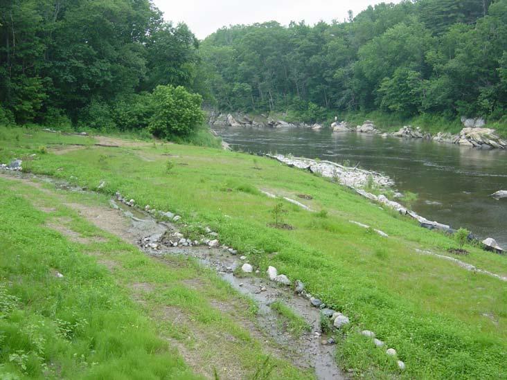
14 June 29, Site post- Phase II implementation. Note granite wall to the left, which was unearthed during Phase I regrading activities. June 29, Site post- Phase II implementation. Note granite wall to the left, which was unearthed during Phase I regrading activities. Page 14 of 16
15 Appendix C: Phase II Adaptive Management Plan Page 15 of 16
16 Appendix D: Match Documentation Page 16 of 16
Tentatively Selected Plan within Harlem River, East River and Western Long Island Sound Planning Region. First Level Costs. Federal Non-Federal Total
 HARLEM RIVER, EAST RIVER AND WESTERN LONG ISLAND SOUND PLANNING REGION Flushing Bay and Creek Ecosystem Restoration Source Feasibility Study Background Study Resolution (1994), Reconnaissance Report (1996),
Juneau Watershed Partnership
 Juneau Watershed Partnership Native Plant Resource Center Final Report A Partners for Fish and Wildlife Project Prepared for: U.S. Fish and Wildlife Service For Grant #F11C00552 Prepared by: The Juneau
OPERATIONS & MAINTENANCE MANUAL FOR POST CONSTRUCTION MEASURES
 OPERATIONS & MAINTENANCE MANUAL FOR POST CONSTRUCTION MEASURES THE CARMONY BUILDING PARAGON REALTY NORTH GREEN STREET BROWNSBURG, HENDRICKS COUNTY INDIANA 8365 Keystone Crossing, Suite 201 Indianapolis,
Department of Agriculture. Conservation Service. United States. Natural Resources REVISED 8/26/16
 GENERAL NOTES: SYMBOL LEGEND 1. All work shall comply with the constriction specifications, drawings, project-specific quality assurance plan and other contract requirements. 2. All notes on the drawings
CITY OF TUMWATER 555 ISRAEL RD. SW, TUMWATER, WA (360) (360) (FAX)
 (360) (FAX)") CITY OF TUMWATER 555 ISRAEL RD. SW, TUMWATER, WA 98501 (360) 754-4180 (360) 754-4126 (FAX) Email: cdd@ci.tumwater.wa.us APPENDIX II-C SHORT FORM CONSTRUCTION STORMWATER POLLUTION PREVENTION PLAN (SWPPP)
CITY OF TUMWATER 555 ISRAEL RD. SW, TUMWATER, WA 98501 (360) 754-4180 (360) 754-4126 (FAX) Email: cdd@ci.tumwater.wa.us APPENDIX II-C SHORT FORM CONSTRUCTION STORMWATER POLLUTION PREVENTION PLAN (SWPPP)
EROSION & SEDIMENT CONTROL
 EROSION & SEDIMENT CONTROL Surface Water Protection During Well Site Construction Kelly Kees, PE WVDEP, Office of Oil and Gas SEDIMENT & EROSION CONTROL PLANS Per West Virginia State Code 22-6-6(d) 22-6A-7(c),
Urban Conservation Practice Physical Effects ESTABLISHMENT, GROWTH, AND HARVEST NUTRIENT MANAGEMENT
 NOT WELL 800 - Urban Stormwater Wetlands A constructed system of shallow pools that create growing conditions for wetland plants to lessen the impacts of stormwater quality and quantity in urban areas.
Guiding Landowners in Stream Restoration. The Science, Practice & Art of Restoring Native Ecosystems 2015
 Guiding Landowners in Stream Restoration The Science, Practice & Art of Restoring Native Ecosystems 2015 January 24, 2015 Guiding Landowners in Stream Restoration January 24, 2015 Agenda 1Watershed Planning
North Carolina Coastal Federation
 North Carolina Coastal Federation Erosion Control: Non-Structural Alternatives A Shorefront Property Owner s Guide Shoreline erosion and landward migration of marshes are natural processes, and are important
Town of Essex Small Site Erosion Control Guide
 Town of Essex Small Site Erosion Control Guide Why do we need to protect against erosion? Water Quality: Erosion and the transport of sediment and pollutants impacts the water quality of nearby streams
Stormwater Standards. Clackamas County Service District No. 1. Planting Guide for Buffers
 Stormwater Standards Clackamas County Service District No. 1 APPENDIX B Planting Guide for Buffers Table of Contents Appendix B - Planting Guide for Buffers... Page B.1 General... 1 B.1.1 Introduction...
Zoning Ordinance Article 3
 Article 3 Natural Resources Protection Section 301 Natural Resources Protection 301.1. Purpose - The following natural resources protection standards are established to protect the public health, safety
City of Stoughton Erosion Control Permit Application (effective 2/6/2018)
") City of Stoughton Erosion Control Permit Application (effective 2/6/2018) Incomplete applications will not be accepted Project Name: Address of subject property: Landowner Name(s): Applicant Name: Landowner
City of Stoughton Erosion Control Permit Application (effective 2/6/2018) Incomplete applications will not be accepted Project Name: Address of subject property: Landowner Name(s): Applicant Name: Landowner
Habitat Improvements to the Motor Island Shoreline in the Upper Niagara River, NY: A Collaborative Approach
 Habitat Improvements to the Motor Island Shoreline in the Upper Niagara River, NY: A Collaborative Approach Edward Alkiewicz 1, Stephen Schoenwiesner 1, Jeff Gerlach 1, Morris Perot 2, Scott Ault 2, Mark
ADDENDUM TO BIOLOGICAL SCOPING SURVEY REPORT, BOTANICAL SURVEY AND WETLAND DELINEATION
 ADDENDUM TO BIOLOGICAL SCOPING SURVEY REPORT, BOTANICAL SURVEY AND WETLAND DELINEATION FOR AVALON INN (APN 069-241-27 & -04) 1201 & 1211 NORTH MAIN STREET FORT BRAGG, CA MENDOCINO COUNTY prepared for:
STREAM ALTERATION PRACTICES
 STREAM ALTERATION PRACTICES Stream Diversion Channel SDC DEFINITION A temporary channel constructed to convey stream flow around in-stream construction. PURPOSE Stream diversion channels are used to allow
Rain Gardens. A Welcome Addition to Your Landscape
 Rain Gardens A Welcome Addition to Your Landscape Where Does The Rainwater Go? Naturally, forests provide a way for rainwater to percolate into the soil, filtering pollutants while trees are allowed to
5.0 Storm Water Landscape Guidance Introduction
 5.0 Storm Water Landscape Guidance Introduction Landscaping is a critical element to improve both the function and appearance of storm water management practices. Integrated storm water landscapes can
2008 Combined Clean Water Legacy Grant Application Id#: Use TAB key to move from field to field
 cwl funds - CWL_FY08Application.doc Page 1 2008 Combined Clean Water Legacy Grant Application Id#: Use TAB key to move from field to field 1. Applicant Organization Applicant Organization:THREE RIVERS
Shelbyville, KY Stormwater Best Management Practices. Section 2 EROSION PREVENTION AND SEDIMENT CONTROL PLAN
 Section 2 EROSION PREVENTION AND SEDIMENT CONTROL PLAN 2.1 Requirements The City of Shelbyville, KY will require an Erosion Prevention and Sediment Control (EPSC) Plan for most types of development construction.
KENT COUNTY STORMWATER MAINTENANCE DISTRICT STORMWATER BMPs MAINTENANCE TASKS AND RESPONSIBILITIES GUIDANCE DOCUMENT BIO-RETENTION FACILITIES
 BIO-RETENTION FACILITIES (for all basins / BMPs) Annually Prepare Operation and Maintenance Plan. Clearly outline how vegetation in the facility and its buffer area will be managed or harvested in the
SOIL EROSION AND SEDIMENT CONTROL
 SOIL EROSION AND SEDIMENT CONTROL SECTION 1: AUTHORITY, TITLE AND PURPOSE 11. STATUTORY AUTHORIZATION This ordinance is adopted pursuant to the provisions of the Federal Water Pollution Control Act 86
C-12. Dry Pond. Design Objective
 C-12. Dry Pond Design Objective The primary purpose of dry pond is to attenuate and delay stormwater runoff peaks. Dry ponds hold water immediately after a storm event and drain to be almost complete dry
POST-FIRE RESTORATION Dos and Don ts
 POST-FIRE RESTORATION Dos and Don ts USDA Natural Resources Conservation Service The NRCS/RCD office is located at: 744 LA GUARDIA ST BLDG A SALINAS, CA 93905-3354 (831) 424-1036 (NRCS) (831) 424-1036
Section 3 Non-Structural BMPs
 3.1 Stream Buffers A stream buffer or stream setback is a designated area around a stream, lake, or wetland left in a natural, densely vegetated state so as to protect the receiving water quality and provide
WAKE COUNTY STORMWATER MAINTENANCE CHECKLIST
 WAKE COUNTY STORMWATER MAINTENANCE CHECKLIST STORMWATER CONTOL STRUCTURE BIORETENTION MAINTENANCE AGREEMENT RESPONSIBLE PARTY: PHONE #: ADDRESS: a. Remove debris from bioretention area. b. Inspect for
SOP 6: Erosion and Sedimentation Control SOP 6: EROSION AND SEDIMENTATION CONTROL
 Standard Operating Procedures Central Massachusetts Regional Stormwater Coalition SOP 6: Erosion and Sedimentation Control SOP 6: EROSION AND SEDIMENTATION CONTROL Erosion and sedimentation from land-disturbing
SECTION 6. Routine Maintenance Activity Details
 SECTION 6 Routine Maintenance Activity Details 80. DEBRIS REMOVAL When Deadfall, and other objects, such as shopping carts, tires, appliances, and mattresses have accumulated in the drain. Why To prevent
Lake and Stream Restoration Project
 Pre-project Fact Sheet May 2012 Toledo Botanical Garden (TBG) is a 60 acre public garden visited by more than 120,000 people annually. It is located in Toledo, Ohio in the Ottawa River watershed within
Landfill Closure, Intermediate Cover & Post-Closure Care. Municipal League Meeting
 Landfill Closure, Intermediate Cover & Post-Closure Care Municipal League Meeting 9-7-17 Gated and Closed Landfill Gated means no longer accepting waste. Closed means gated and final cover has been installed
Environmental Protection Ordinances (Performance Zoning) Bedminster Township, Bucks County
 Bedminster Township, Bucks County") Environmental Protection Ordinances (Performance Zoning) Bedminster Township, Bucks County ARTICLE VI. PERFORMANCE STANDARDS Section 600 Compliance All uses, activities, subdivisions and/or land developments
Environmental Protection Ordinances (Performance Zoning) Bedminster Township, Bucks County ARTICLE VI. PERFORMANCE STANDARDS Section 600 Compliance All uses, activities, subdivisions and/or land developments
Town of Vershire Road Erosion Inventory Report
 Town of Vershire Road Erosion Inventory Report Taylor Valley Road. Photo taken by TRORC staff. Prepared by: 128 King Farm Road Woodstock, VT 05091 Inventory and report funded by the Vermont Agency of Transportation
Panther Pond Conservation Project Phase II
 Panther Pond Conservation Project Phase II 2009-2012 Working to protect and improve the water quality of Panther Pond The Panther Pond Conservation Project Phase II was funded in part by the US Environmental
West Little Pimmit Storm Sewer & John Marshall Green Street Projects. July 7, 2015 Nottingham Elementary School
 West Little Pimmit Storm Sewer & John Marshall Green Street Projects July 7, 2015 Nottingham Elementary School Project Timeline February 2015: Archeological study of island, including historic spring location,
North Branch of Cypress Creek Ecological Restoration: A Comprehensive Approach to Stream Restoration
 North Branch of Cypress Creek Ecological Restoration: A Comprehensive Approach to Stream Restoration Rocky Powell Clear Creeks Consulting, LLC Keith D. Tate, P.E. BayLand Consultants & Designers, Inc.
East Montpelier SWMP Preliminary BMP Summary Sheet BMP ID #: 1 Site name: U-32 High School. Current site type
 East Montpelier SWMP Preliminary BMP Summary Sheet BMP ID #: 1 Site name: U-32 High School 930 Gallison Hill Rd, East Montpelier, VT Filter Berm, Sand Filter, Cistern / Rain Barrel, Gravel Wetland, Check
Draft Rhode Island Stormwater Design and Installation Standards Manual
 Draft Rhode Island Stormwater Design and Installation Standards Manual Summary The May 2009 Public Review Draft version of the RI Stormwater Design and Installation Standards Manual consists of approximately
Lake Nokomis Shoreline Enhancement Project
 Lake Nokomis Shoreline Enhancement Project Community Meeting 2 February 13, 2018 Agenda Current Problems Project Goals Project Status Existing Conditions Community Input Draft Schematic Design Long-term
Post Construction BMPs
 Post Construction BMPs Why are Post Construction BMPs important? With increased development brings the increase of impervious cover Parking lots, rooftops, driveways Storm water runoff volume increases
SUPPORTING DOCUMENT STORMWATER POLLUTION PREVENTION PLAN (SWPPP) NARRATIVE
 NARRATIVE") SUPPORTING DOCUMENT STORMWATER POLLUTION PREVENTION PLAN (SWPPP) NARRATIVE Please complete this narrative form and submit with your SWPPP drawings. Refer to Kitsap County Stormwater Design Manual Vol.
SUPPORTING DOCUMENT STORMWATER POLLUTION PREVENTION PLAN (SWPPP) NARRATIVE Please complete this narrative form and submit with your SWPPP drawings. Refer to Kitsap County Stormwater Design Manual Vol.
Balancing Conservation and Development on the Jordan River
 Balancing Conservation and Development on the Jordan River Jordan River Parkway Trail Regional Athletic Complex Conservation & Restoration Balancing Conservation and Development on the Jordan River Jordan
Wisconsin NRCS Direct Volume Method Bank Recession Rate Categorizations
 2 Executive Summary The City of Ramsey contracted the Anoka Conservation District to complete an inventory of riverbank condition along the entire 5.8 miles of City that border the Mississippi River. The
RAIN GARDEN ILLINOIS URBAN MANUAL PRACTICE STANDARD. (feet) CODE 897 DEFINITION
 CODE 897 DEFINITION") ILLINOIS URBAN MANUAL PRACTICE STANDARD RAIN GARDEN (feet) CODE 897 Source: Kendall County Soil and Water Conservation District DEFINITION Rain gardens are small, shallow, flat bottomed depressions constructed
ILLINOIS URBAN MANUAL PRACTICE STANDARD RAIN GARDEN (feet) CODE 897 Source: Kendall County Soil and Water Conservation District DEFINITION Rain gardens are small, shallow, flat bottomed depressions constructed
Natural Shorelines. for Inland Lakes. A Landowner s Guide to using. to STABLIZE SHORELINES, Michigan s inland lakeshore.
 Natural Shorelines for Inland Lakes A Landowner s Guide to using NATURAL MATERIALS to STABLIZE SHORELINES, IMPROVE WATER QUALITY and ENHANCE WILDLIFE HABITAT along Michigan s inland lakeshore. Natural
Wisconsin Contractors Institute Continuing Education
 Wisconsin Contractors Institute Continuing Education Erosion & Sediment Control Course # 12775 2 hours Wisconsin Contractors Institute N27 W23953 Paul Road, Suite 203 Pewaukee, WI 53072 Website: www.wicontractorsinstitute.com
Stormwater and Your Rain Garden
 Stormwater and Your Rain Garden When rain falls on natural areas, such as a forest or meadow, it is slowed down, filtered by soil and plants, and allowed to soak back into the ground. When rain falls on
Stream Restoration: Working with Nature?
 Stream Restoration: Working with Nature? Greg Jennings, PhD, PE jenningsenv@gmail.com Ecosystem Restoration activities that initiate or accelerate the recovery of ecosystem health, integrity, and sustainability
Stream Restoration: Working with Nature? Greg Jennings, PhD, PE
 Stream Restoration: Working with Nature? Greg Jennings, PhD, PE jenningsenv@gmail.com Ecosystem Restoration activities that initiate or accelerate the recovery of ecosystem health, integrity, and sustainability
Chagrin River Watershed Partners, Inc. Local Regulations. Amy H. Brennan (440)
") Chagrin River Watershed Partners, Inc. Local Regulations Amy H. Brennan (440) 975-3870 www.crwp.org abrennan@crwp.org July 9, 2013 Applicable Zoning and Building Codes Erosion and Sediment Control Grading
Chagrin River Watershed Partners, Inc. Local Regulations Amy H. Brennan (440) 975-3870 www.crwp.org abrennan@crwp.org July 9, 2013 Applicable Zoning and Building Codes Erosion and Sediment Control Grading
APPENDIX A SIMPLIFIED APPROACH TO STORMWATER MANAGEMENT FOR SMALL PROJECTS. In West Sadsbury Township, Chester County, Pennsylvania
 APPENDIX A SIMPLIFIED APPROACH TO STORMWATER MANAGEMENT FOR SMALL PROJECTS In West Sadsbury Township, Chester County, Pennsylvania TABLE OF CONTENTS I. Introduction 3 II. Importance of Stormwater Management
Use of Best Management Practices
 Use of Best Management Practices Presented at the ANJEC Flood Hazard Workshop Bordentown, NJ March 13, 2008 Stormwater BMPs "a technique, measure or structural control that is used for a given set of conditions
Using the Updated RI Soil Erosion and Sediment Control Handbook. The Introductory Workshop for RIDEM/CRMC Staff January 23, 2015
 Using the Updated RI Soil Erosion and Sediment Control Handbook The Introductory Workshop for RIDEM/CRMC Staff January 23, 2015 URI Cooperative Extension NEMO URI Cooperative Extension NEMO White Oak,
Natural Shoreline Landscapes on Michigan Inland Lakes. Introduction. Workshop for Property Owners. Photo by Jane Herbert
 Natural Shoreline Landscapes on Michigan Inland Lakes Workshop for Property Owners Introduction Photo by Jane Herbert MSU is an affirmative action, equalopportunity employer. Michigan State University
WET PONDS INSPECTION & MAINTENANCE CHECKLIST
 WET PONDS INSPECTION & MAINTENANCE CHECKLIST INTRODUCTION Once construction is completed, periodic site inspections are essential in order to monitor the effectiveness and to anticipate the maintenance
Design Considerations for Open Channel and Detention Pond Design. Howard Redfearn, City of Mansfield
 Design Considerations for Open Channel and Detention Pond Design Howard Redfearn, City of Mansfield Previous Experience/Criteria/Maintenance Issues New Criteria Discussion Overview Where is Mansfield?
PICTURE CANYON Planning Riparian-Wetland Refugia in an Urban Setting
 PICTURE CANYON Planning Riparian-Wetland Refugia in an Urban Setting Rio De Flag Existing Conditions. Ephemeral stream; Limited riparian plants, habitats.. & Opportunities Water (effluent) available Restore
4.6. Low Impact and Retentive Grading
 4.6. Low Impact and Retentive Grading Low Impact Grading techniques focus on utilizing existing topography during Site layout to minimize cost. Proposing structures, roads, and other impervious surfaces
July 22, 2013 REQUEST FOR PROPOSALS TO PROVIDE ENGINEERING DESIGN SERVICES FOR A PROJECT ALONG THE WESTERN SHORE OF MOBILE BAY
 Mobile Bay National Estuary Program 4172 Commanders Drive Mobile, AL 36615 Phone: 251-431-6409 Fax: 251-431-6450 Contact: Tom Herder, Watershed Protection Coordinator Email: therder@mobilebaynep.com July
Planning for Staten. Habitat Restoration and Green Infrastructure. Island s North Shore
 Habitat Restoration and Green Infrastructure Planning for Staten Island s North Shore Community Board 1 March 1, 2018 NYC Parks Forestry, Horticulture, and Natural Resources Funded by the NYS Department
RAIN GARDENS. Task: PART 1 (60 minutes) Student Directions: Steps you will be following: Directions for beginning: Source Information:
 Student Directions: Steps you will be following: Directions for beginning: Source Information:") PART 1 (60 minutes) Student Directions: Your assignment: Steps you will be following: Your neighborhood council is researching the benefits of installing rain gardens in your community. You will read two
PART 1 (60 minutes) Student Directions: Your assignment: Steps you will be following: Your neighborhood council is researching the benefits of installing rain gardens in your community. You will read two
Sustainable Sites. hblanarc.ca. RDN Workshop June 25, David Reid, FCSLA, Landscape Architect, Environmental Designer
 Sustainable Sites RDN Workshop June 25, 2011 David Reid, FCSLA, Landscape Architect, Environmental Designer hblanarc.ca Surrey ESA Networks & linear corridors ESA Network: Develop with Care SITE Hub >10
Glencoe Elementary School Parking Lot Retrofit 825 SE 51 st Street
 Glencoe Elementary School Parking Lot Retrofit 825 SE 51 st Street Project Summary Project Type: Technologies: Institutional parking lot retrofit demonstration project Vegetated infiltration swale with
Royal River Youth Conservation Corps
 Royal River Youth Conservation Corps 2007 Summary Report What s Inside: Contributing Partners Introduction Summary of Accomplishments Map of Sites Descriptions and Photos of Work Completed in: Auburn Durham
Alternative Names: Erosion Control Matting, Erosion Control Netting, Rolled Erosion Control Products (RECP)
") 4.5-s EROSION CONTROL BLANKET SYSTEM Alternative Names: Erosion Control Matting, Erosion Control Netting, Rolled Erosion Control Products (RECP) DESCRIPTION Erosion control blanket systems are woven or
4.5-s EROSION CONTROL BLANKET SYSTEM Alternative Names: Erosion Control Matting, Erosion Control Netting, Rolled Erosion Control Products (RECP) DESCRIPTION Erosion control blanket systems are woven or
City of Waco Stormwater Management Regulations
 1.0 Applicability: City of Waco Stormwater Management Regulations These regulations apply to all development within the limits of the City of Waco as well as to any subdivisions within the extra territorial
VEGETATED SLOPE STABILIZATION DESCRIPTION APPLICABILITY. Advantages
 4.2-d VEGETATED SLOPE STABILIZATION Alternative Names: Willow Wattles, Live Bundles, Fascines, Live Staking, Joint Planting, Branch Packing, Brush Layering, and Brush Matting DESCRIPTION Vegetated slope
The Napa River Flood Protection Project
 The Napa River Flood Protection Project Creating Flood Protection and Restoring Geomorphic and Biological Processes Jeremy Sarrow, Napa County Flood Control & Water Conservation District June 2, 2014.
STREAM BANK STABILIZATION THORPS MORTIMER RECREATION AREA Grandfather Ranger District SITE LOCATION & DRAINAGE AREA
 STREAM BANK STABILIZATION THORPS CREEK @ MORTIMER RECREATION AREA SITE LOCATION & DRAINAGE AREA SITE LOCATION Drainage Area = 1.14 sq. miles STREAM BANK STABILIZATION THORPS CREEK @ MORTIMER RECREATION
UPLAND EROSION CONTROL, REVEGETATION, AND MAINTENANCE PLAN
 UPLAND EROSION CONTROL, REVEGETATION, AND MAINTENANCE PLAN 01/17/2003 VERSION UPLAND EROSION CONTROL, REVEGETATION, AND MAINTENANCE PLAN TABLE OF CONTENTS I. APPLICABILITY... 1 II. SUPERVISION AND INSPECTION...
NATURAL LAKE & STREAMBANK PROTECTION & NATURAL BUFFERS. By Sam Martin, Water Management Specialist, Pine SWCD
 NATURAL LAKE & STREAMBANK PROTECTION & NATURAL BUFFERS By Sam Martin, Water Management Specialist, Pine SWCD Natural Lake & Streambank Protection & Natural Buffers Lakeshore & Streambank Erosion Projects
WQ-23 MOUNTAINOUS AND STEEP SLOPE SITES
 Greenville County Technical Specification for: WQ-23 MOUNTAINOUS AND STEEP SLOPE SITES 1.0 Mountainous and Steep Slope Sites 1.1 Description The geographic locations of portions of Greenville County are
Grand River Ravines Georgetown Township
 Grand River Ravines Georgetown Township Project Description: The Grand River Ravines County Park property is composed of the 68-acre former Fillmore at the Bend Open Space purchased in 1999 and two more
Berm and Swale Complex
 Berm and Swale Complex Berm and swale systems are utilized in the landscape to capture, direct and infiltrate rainwater into the soil where it is needed. This complex allows a homeowner to develop a natural
Weston s Wetlands, Stormwater, & Open Space
 Weston s Wetlands, Stormwater, & Open Space Weston s Wetlands, Stormwater, & Open Space Conservation Commission Role and Responsibilities Laws that protect wetlands What residents can do to protect wetlands
Chapter Six: Tree Removal and Erosion Control
 Chapter Six: Tree Removal and Erosion Control Through the combination of canopy and roots, trees help protect and stabilize the land. Their removal requires proper planning and adherence to land-based
RECONNECTING A COMMUNITY TO THE CREEK
 RECONNECTING A COMMUNITY TO THE CREEK 0 The J.J. Seabrook Stream Restoration, Rain Garden, and Urban Trail Project Kristin K. Pipkin, P.E. Michelle Adlong, EI.T. TXSER/TRA Joint Conference November 2,
GUIDELINES FOR ECOLOGICAL PERFORMANCE
 3 Landscape........................................... 3.2 Stormwater Management................................... 3.3 Hardscape........................................... 3.4 Streetscape..........................................
Banking on Natural Fibers Products made from coir and jute play a key role in stabilizing a restored stream for a commercial stream mitigation bank.
 Banking on Natural Fibers Products made from coir and jute play a key role in stabilizing a restored stream for a commercial stream mitigation bank. By Greg Northcutt When White Creek Mitigation, LLC,
Drainage Analysis-Newgate/Phelps & Hatchett Hill Road Areas Rev. 0 Erosion & Sediment Control Measures
 Drainage Analysis-Newgate/Phelps & Hatchett Hill Road Areas Rev. 0 Erosion & Sediment Control Measures 4.0 EROSION & SEDIMENT CONTROL MEASURES After performing the analysis summarized above, Burns & McDonnell
STORMWATER SITE PLAN INSTRUCTIONS AND SUBMITTAL TEMPLATE Medium and Large Projects
 DEPARTMENT OF COMMUNITY DEVELOPMENT 621 Sheridan Street, Port Townsend, WA 98368 Tel: 360.379.4450 Fax: 360.379.4451 Web: www.co.jefferson.wa.us/communitydevelopment E-mail: dcd@co.jefferson.wa.us STORMWATER
PRELIMINARY DRAINAGE REPORT LATHAM 200 MMSCFD GAS PROCESSING PLANT
 PRELIMINARY DRAINAGE REPORT LATHAM 200 MMSCFD GAS PROCESSING PLANT LOTS B, RECORDED EXEMPTION 1211-2-1, RECX13-0096 LOCATED IN THE NORTH 1/2 OF SECTION 2, TOWNSHIP 3 NORTH, RANGE 66 WEST, 6 TH PRINCIPAL
Welcome to Proper Maintenance of
 Welcome to Proper Maintenance of Stormwater Management Facilities [SMF] May 17, 2006 Repp Glaettli This presentation was designed for owners and maintainers of stormwater management facilities. The background
A Review of Green Infrastructure Projects Implemented in the Grand Traverse Region
 A Review of Green Infrastructure Projects Implemented in the Grand Traverse Region Sarah U Ren Program Director The Watershed Center of Grand Traverse Bay 231-935-1514, suren@gtbay.org Our Mission: The
Structural Storm Water Best Management Practices (BMPs)
") Structural Storm Water Best Management Practices (BMPs) Storm Water Permitting: The SWPPP Revealed By Deron Austin, PE January 11, 2006 3:30-5:00 PM Orlando, Florida Presentation Outline Preface About
Structural Storm Water Best Management Practices (BMPs) Storm Water Permitting: The SWPPP Revealed By Deron Austin, PE January 11, 2006 3:30-5:00 PM Orlando, Florida Presentation Outline Preface About
Kickapoo Woods Restoration Plan
 Report Prepared for Friends of the Chicago River Kickapoo Woods Restoration Plan Gully Recommendations 6/30/2014 INTRODUCTION WRD Environmental (WRD) was retained by Friends of the Chicago River to help
Rule D Wetland and Creek Buffers
 Rule D Wetland and Creek Buffers 1 Policy It is the policy of the Board of Managers to ensure the preservation of the natural resources, recreational, habitat, water treatment and water storage functions
Colorado Watershed Protection Fund - Project Grant Application Fountain Creek Restoration Shryver Park Reach Including Shryver Pond
 Fountain Creek - Manitou Springs, CO Shryver Park Reach and Pond Restoration Project Submitted by: The Fountain Creek Restoration Committee & The Pikes Peak Community Foundation April 28, 2008 FCRC Page
Maintaining Your Neighborhood Stormwater Facilities
 Maintaining Your Neighborhood Stormwater Facilities How to identify stormwater facilities and keep them working Layout by the Thurston County Storm and Surface Water Utility with thanks to the Delaware
Guidelines for Streambank Protection
 PDHonline Course C187 (3 PDH) Guidelines for Streambank Protection Instructor: John Poullain, PE 2012 PDH Online PDH Center 5272 Meadow Estates Drive Fairfax, VA 22030-6658 Phone & Fax: 703-988-0088 www.pdhonline.org
Property Owner s Guide to Creek and Shoreline Maintenance
 2014 Property Owner s Guide to Creek and Shoreline Maintenance City of O Fallon This guide for homeowners of creekside property is intended to serve as a reference for helping homeowners understand what
Daylighting Madrona Creek. It takes a neighborhood
 Daylighting Madrona Creek It takes a neighborhood Madrona Park 9 wooded hillside acres above Lk Wa, 2 creeks, (~) 30 mature conifers, lots of ivy, blackberry, 200 vertical feet sloping up from lake. Very
12/7/2007. Christopher B. Burke Engineering West, Ltd Aux Sable Creek Watershed Plan Update 1
 The ABC s of BMP s Aux Sable Watershed Plan St. Charles, IL Why are BMP s Important Best Management Practices (BMPs) developed as a set of practices which help to achieve goals of the Clean Water Act and
Working Group Meeting
 April 4,, 2017 Parks Operations Bldg Working Group Meeting Arts Districts Overview Stormwater/RPA/Stream Considerations First Principles Agenda 7:00pm 7:05pm 7:10pm 7:40pm 8:30pm 9:40pm 9:45pm Welcome
Non-Metallic Mining Reclamation Checklist
 Eau Claire County DEPARTMENT OF PLANNING AND DEVELOPMENT Eau Claire County Courthouse, Rm. 1510 721 Oxford Avenue Eau Claire, Wisconsin 54703-5481 (715) 839-4741 f Housing & Community Development 839-6240
Templates for Maintenance Documents
 Appendix I Templates for Maintenance Documents Example templates are provided to assist project applicants in preparing the following documents, which municipalities may require as exhibits to a stormwater
Huntington Stormwater Utility
 Huntington Stormwater Utility Stormwater Management & Sediment and Erosion Control Requirements for Construction Sites Authorized by Huntington City Code Articles: 971, 970, 930, 935, 955, Revised April
Florence County Small Commercial Land Disturbance Permit Application
 Florence County Small Commercial Land Disturbance Permit Application Florence County Engineering Division 518 South Irby Street Florence, S.C. 29501 Phone (843) 676-8600 Fax (843) 676-8667 Tax Map Number:
Maintaining Your Neighborhood Stormwater Facilities How to identify stormwater facilities and keep them working
 Maintaining Your Neighborhood Stormwater Facilities How to identify stormwater facilities and keep them working Photo to go here Table of Contents Getting to know your Stormwater Facilities..3 Fences and
Tour of Nonpoint Source Pollution Reduction Projects in the Western Lake Superior Watershed
 Tour of Nonpoint Source Pollution Reduction Projects in the Western Lake Superior Watershed On September 8 th, 2006 Minnesota's Lake Superior Coastal Program and the South St Louis Soil and Water Conservation
Green Design Principles
 Green Design Principles restoration planting Ecosystem restoration, including preserving and enhancing existing vegetation and where feasible, introducing new vegetative communities, benefits the stream