Reconnecting rivers in urban areas; challenges and considerations
|
|
|
- Polly McDaniel
- 6 years ago
- Views:
Transcription


1 River Forth Fisheries Trust Reconnecting rivers in urban areas; challenges and considerations RAFTS-ASFB conference 2016
2


3 Currently five morphology project sites in the Forth District with three informing this talk: Dalkeith Weir Montague Bridge Weir Bathgate Watercourse

4 Large weir with head of 3m. Bed scour below has increased height. Crude baulk fish pass with lip at top pass is ineffective. Located immediately upstream of A road bridge. On the grounds of old mill house. Houses upstream and downstream. Design option removal.
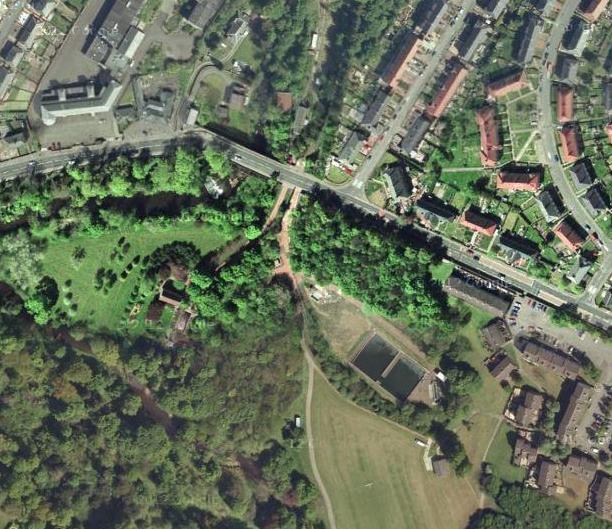
5 Getmapping 2016

6 Large weir with head of over 2m, with drop to river bed of 4m. No fish passage and has prevented passage since Located in Dalkeith park within the town. No immediate housing or civil infrastructure risk. Category A listed building as part of bridge structure. Design option fish pass.
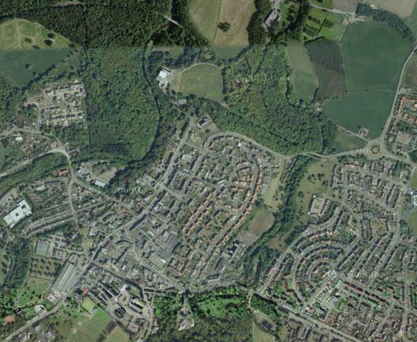
7 Getmapping 2016


8 1.4km of channel. Realigned, resectioned and choked with macrophytes. Floodplain disconnection. Houses, large store, risk of contaminated land, school, graveyard and playing pitches all present. WB failure for WFD. Getmapping, Crown Copyright and RFFT, 2016
 funders (SEPA, HLF, LG, CSGN) Dalkeith and Montague WFD downgrade, structures owned by large landowners, but no economic value.")
9 Who pays? Bathgate - WFD downgrade, deprived location, potential for flood storage. o Range of (potential) funders (SEPA, HLF, LG, CSGN) Dalkeith and Montague WFD downgrade, structures owned by large landowners, but no economic value. o SEPA only, with provision of management money But all multiphase, multiyear projects requiring significant funding and commitment. And main funder difficulties with multi-year projects within phased approach.
10 Phase 1 - Scoping Phase 2 - Design Phase 3 - Build Approach High level Catchment scale Data poor Site scale Data intensive Multidisciplinary Site scale Highly regulated Strict contract Less expensive Guidance Subject to change Expensive Definitive Risky Very expensive Riskiest Final
11 1. Validation visit 3. Land ownership and use Surveys 2. Utilities 4. Terrestrial ecology 5. Aquatic ecology 6. Geological 7. Geomorphology 8. Flood risk 10. Topography 9. Vegetation surveys 11. Sediment grades 12. Sediment composition 13. Structural surveys 14. Instream habitats 15. Contaminated land 16. ECI 17. INNS
12 Licenses/planning/pre-build 1. CAR license of works 2. CAR license of remaining structure 3. EIA screening and process 4. Planning permission pre-app 6. Planning surveys 8. Conservation area consent 5. Planning permission 7. Heritage statement 9. Ecology mitigation

13 Designs and plans Outputs to end Phase 2 But also: Costings and Bill of Quantities for funding and tendering. Planning and licensing for builds/demolitions. Supporting documents (Site access statements, INNS statements, project timelines, mitigation plans...).
14 What were the issues? Many events happened that required compensation events. Mostly foreseen but ; GI had to be commissioned directly Ecological mitigation crossed funder s end of year boundary so was unfunded projects pushed back one year Assumptions based on scoping incorrect Contractual inconsistencies across tenderers Changes to yearly funding arrangements Extraordinarily high costs of contaminated land mitigation. Do we need a new approach?
15 New approach Two phases Detailed Scoping and Design & Build. Phase 1 Site based approach determined by Trust/Board/SEPA. Initial surveys to identify preferred options. Technical surveys (GI, topography, ecology, hydrology) undertaken by consultant to identify show stoppers. Initial design concept produced with estimated build costs. Planning process initiated. Phase 2 Detailed design to support build and planning, mitigation undertaken, contractor appointed and works initiated. Single agency delivery of both phases. Cheaper, quicker, identifies risks earlier, and more deliverable but requires an initial commitment in principle from all parties within a fixed, multi-year framework with clear responsibilities.
16 Otherwise.
17 Thanks to: SEPA Water Environment Fund Midlothian Council West Lothian Council Heritage Lottery Fund Royal Haskoning DHV JBA Consulting
Flood map for the existing situation
 Flood map for the existing situation Flood map after completion construction of the Raciborz reservoir and the WFS modernization WFS tasks: Task no. 1. Enhancement of the Flood Canal Task no. 4. Enhancement
Circular L8/08 2 September Water Services Investment and Rural Water Programmes Protection of Natural Heritage and National Monuments
 Circular L8/08 2 September 2008 Water Services Investment and Rural Water Programmes Protection of Natural Heritage and National Monuments 1. The purpose of this Circular is to provide local authorities
Assessing the impact of smallscale wind energy proposals on the natural heritage
 Scottish Natural Heritage Assessing the impact of smallscale wind energy proposals on the natural heritage Guidance March 2016 Version 3 1 Contents 1. Introduction. 3 2. Encouraging a spatial approach
CAIRNGORMS NATIONAL PARK AUTHORITY
 DEVELOPMENT PROPOSED: Removal of Gravel Embankments at Allt an t-slugain, Invercauld Estate, Braemar REFERENCE: 2016/0082/DET APPLICANT: Scottish Natural Heritage DATE CALLED-IN: 5 th April 2016 RECOMMENDATION:
Environmental Impact Assessment. York Glasgow Edinburgh
 Environmental Impact Assessment York Glasgow Edinburgh Our Services Our Approach EIA (Environmental Impact Assessment) ASSESSMENTS Environmental Impact Assessment (EIA) Environmental Statements and Reports
The Duke s River: Revitalising the link between the River Crane and the River Thames
 The Duke s River: Revitalising the link between the River Crane and the River Thames The project The eastern section of the Duke of Northumberland s River runs for approximately four kilometres, from where
Landscape and Heritage A Park landscape that embraces the physical, cultural and social heritage of the area
 80 Park Development Framework Our Aim for Landscape and Heritage A Park landscape that embraces the physical, cultural and social heritage of the area Why do we think it is important? The landscapes of
Landscape and Heritage
 86 Park Development Framework Our Aim for A Park landscape that embraces the physical, cultural and social heritage of the area Why do we think it is important? The landscape provides a setting for every
VALLEY VIEW POND Q&A. This item will be discussed under the First Reading portion of the agenda at the July 17, 2012 Village Council meeting.
 VALLEY VIEW POND Q&A This item will be discussed under the First Reading portion of the agenda at the July 17, 2012 Village Council meeting. 1. Please provide a history of the pond including Village maintenance
Scarborough Waterfront Project
 Scarborough Waterfront Project Public Information Centre #1 Environmental Assessment Terms of Reference September 10, 2014 Agenda Open House Presentation 7:00 to 7:30 pm Presentation 7:30 to 8:15 pm History
3 Urban Design and the State Highway Network
 NZ Transport Agency Page 1 of 14 Urban Design Professional Services Guide 1 Introduction This is a professional services guide on urban design, which provides direction to the NZ Transport Agency (NZTA)
BANDON FLOOD RELIEF SCHEME
 WHAT HAPPENS NEXT? All comments received in response to this Public Information Event will be considered by the OPW and will be taken into account in the preparation of the first stage in the Bandon Flood
REQUEST FOR PROPOSALS Saint Vrain Creek Watershed Master Planning
 REQUEST FOR PROPOSALS Saint Vrain Creek Watershed Master Planning March 7, 2014 Issued by: Boulder County 1 PROPOSALS REQUESTED FOR MASTER PLANNING Funded by a grant from the Colorado Water Conservation
Letcombe Brook Project Officer
 Letcombe Brook Project Officer Job Description Responsible to: Responsible for: Purpose of post: Key Committees: Chairman and Trustees of Letcombe Brook Project. Project volunteers and any relevant personnel
Hydrology, Flood Risk + SuDS. York Glasgow Edinburgh
 Hydrology, Flood Risk + SuDS York Glasgow Edinburgh Our services Our Approach Hydrology, Flood Risk + SuDS ASSESSMENTS Flood Risk Assessment Flood Consequence Assessment Drainage Impact Assessment Environmental
STREAM BANK STABILIZATION THORPS MORTIMER RECREATION AREA Grandfather Ranger District SITE LOCATION & DRAINAGE AREA
 STREAM BANK STABILIZATION THORPS CREEK @ MORTIMER RECREATION AREA SITE LOCATION & DRAINAGE AREA SITE LOCATION Drainage Area = 1.14 sq. miles STREAM BANK STABILIZATION THORPS CREEK @ MORTIMER RECREATION
Arkansas River Corridor
 Planning for Access Welcome to the Access Project. This project is a recreational planning effort in response to an interest by regional communities along the Arkansas River corridor. The project plan
M4 Corridor around Newport Environmental Statement Volume 3: Appendices
 Environmental Statement Volume 3: Appendices Environmental Statement Volume 3: Appendices At Issue March 2016 CVJV/AAR 3 rd Floor Longross Court, 47 Newport Road, Cardiff CF24 0AD Volume 3: Contents 1
PROPOSED RESIDENTIAL DEVELOPMENT LAND AT GREEN LANE, YARM
 PROPOSED RESIDENTIAL DEVELOPMENT LAND AT GREEN LANE, YARM PUBLIC CONSULTATION YOUR VIEW MATTERS TO US LOCATION PLAN Thank you for taking the time to read this information leaflet regarding a proposed residential
Making Space for Nature A Leicester Case Study. Dr Helen O Brien Leicester City Council
 Making Space for Nature A Leicester Case Study Dr Helen O Brien Leicester City Council Helen.Obrien@Leicester.gov.uk Definitions Biodiversity (biological diversity) The variety of plant and animal life
Development Permit Application Form. Property Owner Information as Registered on Legal Title Property Owner Name: Phone:
 Development Application Requirements 1 1926 Tsawwassen Drive Tel: 604-943-2112 Tsawwassen, BC V4M 4G2 www.tsawwassenfirstnation.com Canada Development Permit Application Form Name of Applicant: Address:
AMENDMENT NO. 30 TO THE OFFICIAL PLAN OF THE TOWN OF MILTON
 AMENDMENT NO. 30 TO THE OFFICIAL PLAN OF THE TOWN OF MILTON Subject: Boyne Survey Secondary Plan and Related Official Plan Amendments The following text and schedules constitute Amendment No. 30 to the
New techniques for urban river rehabilitation
 New techniques for urban river rehabilitation (WP8) URBEM Urban River Basin Enhancement Methods New techniques for urban river rehabilitation Methodology Work Package 8 LNEC João Rocha Elsa Alves EVK-CT-2002-00082
Initial OPW Designation APSR AFRR IRR Co-ordinates Easting: Northing: Fluvial non-tidal Fluvial tidal Coastal
 Location: Athlone, Co. Westmeath (including townland in Roscommon) Unique ID: 260448 (from PFRA database) Initial OPW Designation APSR AFRR IRR Co-ordinates Easting: 205000 Northing: 239999 River / Catchment
TOWN AND COUNTRY PLANNING ACT 1990 (AS AMENDED).
.") FAO: D. Williams Isle of Anglesey County Council Council Offices Llangefni Anglesey LL77 7TW 16 November 2017 DCRM Ref. No: WN0904-QUD-OS-LET-00002_English Dear Mr Williams TOWN AND COUNTRY PLANNING ACT
FAO: D. Williams Isle of Anglesey County Council Council Offices Llangefni Anglesey LL77 7TW 16 November 2017 DCRM Ref. No: WN0904-QUD-OS-LET-00002_English Dear Mr Williams TOWN AND COUNTRY PLANNING ACT
Ashbridges Bay Erosion and Sediment Control Project
 Ashbridges Bay Erosion and Sediment Control Project Project Brief Overview Toronto and Region Conservation Authority, in partnership with the City of Toronto, intends to carry out remedial erosion control
Morpeth Flood Alleviation Scheme. An Example of Partnership Funding & Community Engagement
 Morpeth Flood Alleviation Scheme An Example of Partnership Funding & Community Engagement Ruth Bendell Infrastructure Manager - Northumberland County Council Chair of the TAG FCRM Committee Overview Setting
SHORELINE, FLOOD AND COASTAL DEFENCE MANAGEMENT PLANS
 These plans may provide opportunities as well as concern for recreational boating. They are currently being revised and consulted on. This document explains how we can engage in the process. Shoreline,
River Restoration in Urban Areas. Petra Podraza
 River Restoration in Urban Areas Petra Podraza 1 Rivers for the Life of Towns 2007 Main Problems in Urban Rivers water quality discharge volume (floods and peak flow condition) technical constructed river
Holnicote Multi-Objective Flood Demonstration Project Steve Rose (JBA)
") Holnicote Multi-Objective Flood Demonstration Project Steve Rose (JBA) Pete Worrall (PAA), Gene Hammond (PAA), Nigel Hester (NT) & Zdenka Rosolova (JBA) Introduction Objectives Identify landscape scale
Holnicote Multi-Objective Flood Demonstration Project Steve Rose (JBA) Pete Worrall (PAA), Gene Hammond (PAA), Nigel Hester (NT) & Zdenka Rosolova (JBA) Introduction Objectives Identify landscape scale
Witteveen+Bos. Strategy // Planning // Design for resilient urban places. Rachael Cox April 2017
 Healthy Witteveen+Bos: & Resilient Cities: Designing Urban Healthy Planning & and Resilient Engineering Cities 1 Witteveen+Bos Strategy // Planning // Design for resilient urban places Rachael Cox April
Master Environmental Servicing Plan & Secondary Plan
 East Side Lands Stage 2 1 Master Environmental Servicing Plan & Secondary Plan Public Information Centre #1 June 16, 2016 Welcome! Today s Agenda Please sign in at the front desk. 5:30 pm 6:30 pm: Open
Fluvial non-tidal Fluvial tidal Coastal. PFRA database comments (in italics): OPW comments Minor flooding of residents on golf links road
: OPW comments Minor flooding of residents on golf links road") Location: Charleville, Co. Cork Unique ID: 240375 (from PFRA database) Initial OPW Designation APSR AFRR IRR Co-ordinates Easting: 152250 Northing: 122500 River / Catchment / Sub-catchment Glen River /
Location: Charleville, Co. Cork Unique ID: 240375 (from PFRA database) Initial OPW Designation APSR AFRR IRR Co-ordinates Easting: 152250 Northing: 122500 River / Catchment / Sub-catchment Glen River /
Barvills Solar Farm Environmental Statement Non-Technical Summary
 Barvills Solar Farm Environmental Statement Non-Technical Summary 13 March 2015 Produced for Prepared by St John s House Queen Street, Manchester M2 5JB Contents Contents... 2 1 Introduction... 3 1.1 Development
Lower Don River West Remedial Flood Protection Project TABLE OF CONTENTS. Page. Executive Summary
 TABLE OF CONTENTS Page Executive Summary 1.0 INTRODUCTION...1-1 1.1 Purpose of the Undertaking...1-1 1.2 Study Area Description...1-1 1.3 Description of the Undertaking...1-1 1.4 Rationale for the Undertaking...1-2
Wise use of floodplains - a demonstration of techniques to evaluate and plan floodplain restoration LIFE99 ENV/UK/000203
 Wise use of floodplains - a demonstration of techniques to evaluate and plan floodplain restoration LIFE99 ENV/UK/000203 Project description Environmental issues Beneficiaries Administrative data Read
HERITAGE POLICY...Safeguarding the Built Heritage. Conservation Plans. A Guide to the Preparation of Conservation Plans
 HERITAGE POLICY...Safeguarding the Built Heritage Conservation Plans A Guide to the Preparation of Conservation Plans 1 2 1.0 INTRODUCTION 1.1 Scotland has a diverse built heritage: ancient monuments and
Wyvern Park Skipton Environmental Statement. Non-technical Summary - April 2015
 Wyvern Park Skipton Environmental Statement Non-technical Summary - April 2015 BWB Consulting Ltd Whitehall Waterfront 2 Riverside Way Leeds LS1 4EH Telephone: +44(0)113 233 8000 Copyright This Report
FAQ S about Restoration Planning FROM THE Department of Ecology WEBSITE:
 FAQ S about Restoration Planning FROM THE Department of Ecology WEBSITE: http://www.ecy.wa.gov/programs/sea/sma/st_guide/smp/restoration/qanda.html Notations in parentheses are staff notes directing you
Unique ID: (from PFRA database) Location: Birr, Co. Offaly. Stage 1: Desktop Review
 Location: Birr, Co. Offaly. Stage 1: Desktop Review") Location: Birr, Co. Offaly Unique ID: 250410 (from PFRA database) Initial OPW Designation APSR AFRR IRR Co-ordinates Easting: 206,007 Northing: 204,990 River / Catchment / Sub-catchment Camcor River /
Location: Birr, Co. Offaly Unique ID: 250410 (from PFRA database) Initial OPW Designation APSR AFRR IRR Co-ordinates Easting: 206,007 Northing: 204,990 River / Catchment / Sub-catchment Camcor River /
Thank you for coming. We want to hear your views on proposed improvements to the A1 between junction 65 (Birtley) and junction 67 (Coal House).
 and junction 67 (Coal House).") Welcome Thank you for coming. We want to hear your views on proposed improvements to the between junction 65 (Birtley) and junction 67 (Coal House). This is your opportunity to provide comments on our
Welcome Thank you for coming. We want to hear your views on proposed improvements to the between junction 65 (Birtley) and junction 67 (Coal House). This is your opportunity to provide comments on our
River Kleine Nete : Creating ecological flooding zones at recreation areas
 Stoffel Moeskops Lange Kievitstraat 111-113 bus 64 B-2018 ANTWERPEN T +32 3 205 81 25 s.moeskops@vmm.be River Kleine Nete : Creating ecological flooding zones at recreation areas \\\\\\\\\\\\\\\\\\\\\\\\\\\\\\\\\\\\\\\\\\\\\\\\\\\\\\\\\\\\\\\\\\\\\\\\\\\\\\\\\\\\\\\\\\\\\\\\\\\\\\\
Note on Habitat Management for Pool Frog Reintroduction Thompson Common
 Note on Habitat Management for Pool Frog Reintroduction Thompson Common Contents 1. INTRODUCTION AND BACKGROUND... 1 1.1. Contractual background... 1 2. MANAGEMENT WORK... 2 2.1. Ongoing habitat restoration
Kootenai River Habitat Restoration Program June 18, 2018 Kootenai Valley Resource Initiative Update
 Kootenai River Habitat Restoration Program June 18, 2018 Kootenai Valley Resource Initiative Update Kootenai River Habitat Restoration Program Multi-year habitat restoration program Restoration treatments
The Napa River Flood Protection Project
 The Napa River Flood Protection Project Creating Flood Protection and Restoring Geomorphic and Biological Processes Jeremy Sarrow, Napa County Flood Control & Water Conservation District June 2, 2014.
Kier Infrastructure and Overseas Limited Greenburn Surface Mine, Dalgig Farm Site
 Kier Infrastructure and Overseas Limited Greenburn Surface Mine, Dalgig Farm Site Planning application pursuant to s.42 Town and Country Planning (Scotland) Act 1997 to amend the restoration scheme Volume
Velindre Cancer Centre Environmental Statement Vol.1: Environmental Statement Text. Chapter 1: Introduction
 Velindre Cancer Centre Environmental Statement Vol.1: Environmental Statement Text Chapter 1: Introduction Draft - March 2017 Prepared by: Address: Email: Website: Mott McDonald, The Urbanists and HLM
 Skipton Flood Alleviation Scheme Environmental Statement We are the Environment Agency. We protect and improve the environment and make it a better place for people and wildlife. We operate at the place
Sustainable Urban Drainage Systems (SuDs)
") Sustainable Urban Drainage Systems (SuDs) Brendan Colgan, Chartered Engineer Hydrological Cycle - managing the entire cycle is the goal Disruption of the Hydrological Cycle Why use SuDS? G Traditional
Sustainable Urban Drainage Systems (SuDs) Brendan Colgan, Chartered Engineer Hydrological Cycle - managing the entire cycle is the goal Disruption of the Hydrological Cycle Why use SuDS? G Traditional
AECOM Wolverhampton City Centre Metro Extension Environmental Impact Assessment Scoping Report 64
 AECOM Wolverhampton City Centre Metro Extension Environmental Impact Assessment Scoping Report 64 14 Conclusions It can be concluded from the scoping report that the following topics should be scoped in
3-2 Environmental Systems
 3-2 Environmental Systems 3.0 ENVIRONMENTAL SYSTEMS CONTENTS 3.1 GREENWAY SYSTEM 3.1.1 General Policies 3.1.2 Natural Heritage Network 3.1.3 Natural Heritage Network Enhancement Lands 3.1.4 Rouge Watershed
TRCA Field Staking Protocol December 2016
 Page 1 of 6 TRCA Field Staking Protocol December 2016 This Protocol describes TRCA staff s current practice for field staking the physical top of bank, the physical toe of slope, and the limit of existing
Step by step, the construction of a coherent overall restoration on the Seine estuary the role of GIP Seine-Aval
 Step by step, the construction of a coherent overall restoration on the Seine estuary the role of GIP Seine-Aval Stéphanie Moussard GIP Seine-Aval Seine estuary - France I-Introduction to the Seine estuary
PURPOSE OF MEETING MEETING GUIDELINES PROJECT BACKGROUND ESKOM CLOCOLAN-FICKSBURG 88 KV POWERLINE, FREE STATE
 ESKOM CLOCOLAN-FICKSBURG 88 KV POWERLINE, FREE STATE DRAFT BASIC ASSESSMENT REPORT PUBLIC REVIEW LANDOWNERS MEETING FICKSBURG 23 JULY 2013 T his project is being conducted on behalf of Eskom PRESENTATION
In Title Your Area 10: Lower Boddington to Southam & Offchurch
 LOCAL AREA In Title Your Area 10: Lower Boddington to Southam & Offchurch Find out here about: what is proposed between Lower Boddington and Southam & Offchurch; what this means for people living between
Bigger Better and. Giving nature a home in the Trent Valley: Newark to South Clifton Concept Plan
 Bigger Better and Giving nature a home in the Trent Valley: Newark to South Clifton Concept Plan Our 2050 vision Objectives The Trent and Tame River Valleys will once again be one of the great British
HS2 EIA Scope and Methodology Consultation
 HS2 EIA Scope and Methodology Consultation Response from The Wildlife Trusts (England) May 2012 ENGLAND The Wildlife Trusts The Kiln, Waterside, Mather Road, Newark, NG24 1WT Registered Charity No. 207238
Town and Country Planning (Environmental Impact Assessment Regulations) 2011 SCOPING OPINION
 2011 SCOPING OPINION") Town and Country Planning (Environmental Impact Assessment Regulations) 2011 SCOPING OPINION Application Site and Description of Development Proposed new quarry at Culham, Oxfordshire Land and Mineral
Town and Country Planning (Environmental Impact Assessment Regulations) 2011 SCOPING OPINION Application Site and Description of Development Proposed new quarry at Culham, Oxfordshire Land and Mineral
An Ambitious Plan: Transforming the blighted South Platte River and surrounding environment into Denver s greatest natural resource.
 CONNECTING THE PEOPLE TO THEIR RIVER SOUTH PLATTE RIVER VISION IMPLEMENTATION PROGRAM: GRANT-FRONTIER PARK TO OVERLAND POND PARK REACH The South Platte River Vision Implementation Program (River Vision)
Comments on the proposed scope are requested from WCC/NBBC officers to be provided to SLC Rail by 25 th March 2016 and sent to
 Introduction WCC have indicated that in advance of the surveys and assessments being undertaken consultation should be undertaken with technical officers of both Warwickshire CC and Nuneaton and Bedworth
MADRID MINING LANDSCAPE Western Planner/Nevada APA Conference. A New Mexico Abandoned Mine Land (AML) Program Community-Based Planning Project
 Program Community-Based Planning Project") MADRID MINING LANDSCAPE 2013 Western Planner/Nevada APA Conference A New Mexico Abandoned Mine Land (AML) Program Community-Based Planning Project Presented by: Ken Romig, ASLA Associate, Dekker/Perich/Sabatini
MADRID MINING LANDSCAPE 2013 Western Planner/Nevada APA Conference A New Mexico Abandoned Mine Land (AML) Program Community-Based Planning Project Presented by: Ken Romig, ASLA Associate, Dekker/Perich/Sabatini
Vaughan Metropolitan Centre (VMC) Black Creek Renewal CLASS ENVIRONMENTAL ASSESSMENT
 Black Creek Renewal CLASS ENVIRONMENTAL ASSESSMENT") PUBLIC INFORMATION CENTRE Vaughan Metropolitan Centre (VMC) Black Creek Renewal Wednesday, May 10, 2017 6:00 p.m. to 8:00 p.m. Add photo Project Management, Environmental Assessment, Stormwater Management
PUBLIC INFORMATION CENTRE Vaughan Metropolitan Centre (VMC) Black Creek Renewal Wednesday, May 10, 2017 6:00 p.m. to 8:00 p.m. Add photo Project Management, Environmental Assessment, Stormwater Management
HARDWICK GREEN, King s Lynn. Welcome to our Exhibition. What are your views? Introduction to the site and proposals. About us
 HARDWICK GREE, King s Lynn Welcome to our Exhibition Welcome to our exhibition, which is being held to provide you with the opportunity to understand and comment upon our proposals for new residential
Chalk, Cherries and Chairs Central Chilterns Landscape Partnership Scheme LANDSCAPE PARTNERSHIP DEVELOPMENT OFFICER JOB INFORMATION PACK
 Chalk, Cherries and Chairs Central Chilterns Landscape Partnership Scheme LANDSCAPE PARTNERSHIP DEVELOPMENT OFFICER JOB INFORMATION PACK How to apply Please complete our application form, together with
Policy DM19: Development and Nature Conservation
 Avonmouth Wetland Habitat Project October 2010 and December 2011 (the Cresswell study). Policy Links Bristol Local Plan Core Strategy Lead Policy BCS4: Avonmouth and Bristol Port BCS9: Green Infrastructure
TORONTO TRANSIT COMMISSION AND THE REGIONAL MUNICIPALITY OF YORK
 TORONTO TRANSIT COMMISSION AND THE REGIONAL MUNICIPALITY OF YORK NOTICE OF PREPARATION OF AN ADDENDUM REPORT TO THE HIGHWAY 7 CORRIDOR AND VAUGHAN NORTH-SOUTH LINK ENVIRONMENTAL ASSESSMENT & RESPONSE TO
17 NOVEMBER 2015 PLANNING COMMITTEE. on Cttee Day: 73/73. Land To The Rear Of Brook Farm Rickford Worplesdon, Bagshot Road, Woking, Surrey
 5l 14/0218 Reg d: 27.06.14 Expires:20.11.15 Ward: BR Nei. 17.07.14 BVPI Con. Target: 18 Exp: Number of Weeks On Target? on Cttee Day: 73/73 Y LOCATION: PROPOSAL: TYPE: Land To The Rear Of Brook Farm Rickford
water resource specialists
 Vaughn Collins, PE, CFM, Northwest Hydraulic Consultants Brad Livingston, Oregon Department of Transportation Melissa Reich, North Coast Land Conservancy Location Necanicum River 75 sq mi watershed Active
XII IX VIII NON-TECHNICAL SUMMARY OF ENVIRONMENTAL STATEMENT. Redevelopment of the Laverstoke Mill Complex
 Laverstoke Mill XI XII Redevelopment of the Laverstoke Mill Complex I X NON-TECHNICAL SUMMARY OF ENVIRONMENTAL STATEMENT November 29 IX VIII St James Group Ltd Berkeley House, 19 Portsmouth Road, Cobham,
Highlands Region Stormwater Management Program Guidance
 DRAFT Highlands Region Stormwater Management Program Guidance Release Date: January 2016 Abstract This guidance document provides an overview of the Highlands Stormwater Management Program. It is intended
Rapid Transit Implementation Working Group September 14, 2017
 Rapid Transit Implementation Working Group September 14, 2017 BACKGROUND Council approved the Rapid Transit Master Plan and Updated Business Case on July 25, 2017. Approval of the RTMP confirmed the BRT
MAPPING THE BENEFITS OF THE GREEN NETWORK: A NEW TOWN CASE STUDY
 MAPPING THE BENEFITS OF THE GREEN NETWORK: A NEW TOWN CASE STUDY Illustrating the use of the EcoServ- GIS toolkit to quantify the benefits of nature and the green network across Cumbernauld, North Lanarkshire.
Draft Rhode Island Stormwater Design and Installation Standards Manual
 Draft Rhode Island Stormwater Design and Installation Standards Manual Summary The May 2009 Public Review Draft version of the RI Stormwater Design and Installation Standards Manual consists of approximately
Edgeley Pond + Park Public Meeting
 Edgeley Pond + Park Public Meeting February 21, 2017 Purpose of the meeting This Public Meeting is an opportunity for you to review the project background, process and provide input. City of Vaughan staff
Frequently Asked Questions
 1. Where is Aylesbury Woodlands? Frequently Asked Questions Aylesbury Woodlands lies to the east of Aylesbury. It is bounded to the south by the A41. To the north is the Aylesbury Arm of the Grand Union
Washington County, Maryland Division of Public Works Policy Manual
 Washington County, Maryland Division of Public Works Policy Manual Subject: Downstream Drainage Easement Category: Land Development Engineering Number: 7-4.1 Date: June 1, 2009 (effective) PURPOSE: The
STORM SEWER OUTFALLS AND CONNECTING OUTFALL CHANNELS. General Submission Requirements
 COMPLETE APPLICATION CHECKLIST Jan 2016 STORM SEWER OUTFALLS AND CONNECTING OUTFALL CHANNELS The following checklist has been compiled to assist the applicant in preparing their application for approval
LAND EAST OF SUDBURY ROAD, HALSTEAD PUBLIC CONSULTATION. Proposed Residential Development
 LAND EAST OF SUDBURY ROAD, HALSTEAD PUBLIC CONSULTATION Proposed Residential Development YOUR VIEW MATTERS TO US PROPOSED RESIDENTIAL DEVELOPMENT AREA Thank you for taking the time to read this information
1. Introduction
 Table of Contents 1. Introduction... 1-1 1.1 Project Background... 1-1 1.2 Project Goals and Objectives... 1-3 1.3 Proponent... 1-5 1.4 The Ontario EA Act... 1-6 1.4.1 Co-ordinated EA Process... 1-9 1.4.2
Leading environmental solutions...
 Leading environmental solutions... About Us Australian Wetlands Consulting (AWC) is a multi-award winning environmental design and consulting company committed to creating a better environment through
Case Study Presentation of the Downtown Brampton Flood Protection Class EA
 Case Study Presentation of the Downtown Brampton Flood Protection Class EA Presented by: Kenneth M. Dion, Project Director Port Lands Integration, Waterfront Toronto (formerly Senior Manager, TRCA) At:
Published in March 2005 by the. Ministry for the Environment. PO Box , Wellington, New Zealand ISBN: X.
 Action Pack Published in March 2005 by the Ministry for the Environment Manatū Mō Te Taiao PO Box 10-362, Wellington, New Zealand ISBN: 0-478-18994-X ME number: 580 This document is available on the Ministry
HS2 Environment. Protecting the environment
 HS2 Environment Protecting the environment Approach to mitigation EIA Regulations require an ES to include a description of the measures envisaged in order to avoid, reduce and, if possible, remedy significant
Stream Corridor Management Plan
 Stream Corridor Management Plan A unified and comprehensive approach to protecting, restoring and managing the Upper Delaware River Graydon Dutcher Delaware County Soil and Water Conservation District
CSGN DEVELOPMENT FUND Projects Awarded Funding April 2013
 CSGN DEVELOPMENT FUND 2013-14 - 2014-15 Projects Awarded Funding April 2013 This document provides details of all projects receiving funding from the CSGN Development Fund in 2013-14 and 2014-15. This
The use of low head weirs to. perennial streams with their floodplains:
 The use of low head weirs to reconnect severely entrenched perennial streams with their floodplains: An Anne Arundel County TMDL Watershed Implementation Plan Strategy presented by Hala Flores, P.E Mid
Is a Riparian Restoration Still Viable After 100-year Storm Events Alter the Original Design?
 Is a Riparian Restoration Still Viable After 100-year Storm Events Alter the Original Design? Sarah Spear Cooke, Ph.D. Seattle, Washington Presentation Outline Introduction The site pre-restoration Restoration
Hawick Flood Protection Scheme
 ENVIRONMENTAL STATEMENT VOLUME 3: NON-TECHNICAL SUMMARY Hawick Flood Protection Scheme Prepared for Scottish Borders Council March 2017 CH2M HILL City Park 368 Alexandra Parade Glasgow, G31 3AU Tel: +44
CAIRNGORMS NATIONAL PARK AUTHORITY
 Title: REPORT ON CALLED-IN PLANNING APPLICATION Prepared by: KATHERINE DONNACHIE (SENIOR PLANNING OFFICER, DEVELOPMENT MANAGEMENT) DEVELOPMENT PROPOSED: FULL PLANNING PERMISSION FOR REPLACEMENT BRIDGE
SECTION 5: REACH RECOMMENDATIONS/MAPS
 SECTION 5: REACH RECOMMENDATIONS/MAPS This section describes areas of concern and provides specific recommendations for each project reach. Locations of stormwater drains were from GIS coverage supplied
Green Networks in Planning Policy and Management
 Promoting green networks in the Lothians & Fife delivering economic, social & ecological benefits in partnership, as part of the Central Scotland Green Network funded by: Green Networks in Planning Policy
OVERMOUNTAIN VICTORY TRAIL BURKE CALDELL CORRIDOR FEASIBLITY STUDY REQUEST FOR QUALIFICATIONS CALDWELL COUNTY PATHWAYS
 OVERMOUNTAIN VICTORY TRAIL BURKE CALDELL CORRIDOR FEASIBLITY STUDY REQUEST FOR QUALIFICATIONS CALDWELL COUNTY PATHWAYS Caldwell County Pathways along with our co-partners City of Lenoir, Town of Gamewell,
Environmental Impact Assessment for Waterway Restoration Projects. Chris John, Technical Director Ecus Ltd.
 Environmental Impact Assessment for Waterway Restoration Projects Chris John, Technical Director Ecus Ltd. Environmental Impact Assessment for Waterway Restoration Projects What is Environmental Impact
Grantham Southern Quadrant Link Road Environmental Statement
 Grantham Southern Quadrant Link Road Environmental Statement Non Technical Summary Introduction Lincolnshire County Council (LCC) is submitting a planning application for the proposed implementation of
Cost 24.1m Benefit Cost Ratio: Potential Measures. A2 - Verdant Place Steps and Crèche. A5 - Star Rovers to Athlunkard Boat Club
 Introduction Limerick City and County Council has appointed the Arup JBA team to assess, develop and design a sustainable flood relief scheme for King s Island. This is our third public consultation event.
Technical note. Option 3a (cyan route) Project: To: A428 Bus Enhancement Scheme. Rid Hollands, Colin Young
 Project: To: A428 Bus Enhancement Scheme. Rid Hollands, Colin Young") Project: A428 Bus Enhancement Scheme To: Rid Hollands, Colin Young Subject: Flood Risk Desktop study From: Liz Hillcoat, Charlotte Nunns Date: 26 Jan 2017 cc: Term Awarded Watercourse Main River Ordinary
Project: A428 Bus Enhancement Scheme To: Rid Hollands, Colin Young Subject: Flood Risk Desktop study From: Liz Hillcoat, Charlotte Nunns Date: 26 Jan 2017 cc: Term Awarded Watercourse Main River Ordinary
Meeting Agenda. City of Guelph. River Systems Advisory Committee. Agenda Items. Item 1, 2 and 3. Item 4 Ward to Downtown Pedestrian Bridge
 Meeting Agenda City of Guelph River Systems Advisory Committee September 19, 2018 City Hall, Meeting Room B From 4:00 to 6:00 p.m. Meeting Chair: Mariette Pushkar Agenda Items Welcome to all Item 1, 2
NON-TECHNICAL SUMMARY
 Proposed Sand and Gravel Extraction and Associated Processing Operations with Restoration to a Mixture of Agriculture and Nature Conservation including Areas of Shallow Water at Hedgeley, Northumberland
Ballincollig Carrigaline Municipal District
 Ballincollig Carrigaline Municipal District Local Area Plan 21 st August 2017 VOLUME THREE Map Browser 3 Map Browser Volume 3 Map Browser List of maps available to view on the Local Area Plan Map Browser:
Ongar. Residential Sites. Vision for Ongar
 5.58 Located in the east of the district, is a District Centre of medieval origin that boasts a retail and service offer benefiting the local community and those in other settlements further afield. 5.59