Flood map for the existing situation
|
|
|
- Daniela Mathews
- 6 years ago
- Views:
Transcription

1

2 Flood map for the existing situation
3 Flood map after completion construction of the Raciborz reservoir and the WFS modernization
4 WFS tasks: Task no. 1. Enhancement of the Flood Canal Task no. 4. Enhancement of the Old Odra from the Psie Pole weir to the Poznanskie bridges Task no. 5. Enhancement of the City Canal Task no. 6. Redevelopment of the Odra river-bed from the Poznanskie bridges to the estuary of Widawa Task no. 7. Extension of the Redzin barrage Task no. 9. Modernization of the Old Town Odra boulevards Task no. 10. Redevelopment of the Wroclaw I weir
5 Location of the Investment
6 Location of the Investment
7 Main surface water body within Investment area 1) PLRW Odra within Wroclaw/Odra within the boundaries of Wrocław 2) PLRW Odra from boundaries of Wroclaw to Wały Śląskie HMWB Abiotic type: 21 - large lowland river Environmental objectives: good ecological potential and good chemical status Art 4.7 exemptions
8 Environmental objectives for protected areas nutrient-sensitive areas: There is preservation area sensitive to eutrophication resulting from contamination from municipal sources areas designated for the protection of habitats or species where the maintenance or improvement of the status of water is an important factor in their protection: There are two Natura 2000 sites in the immediate vicinity as well as within the boundaries of both WB in the scope of the implementation of the Investment: - Special Area of Habitat Conservation (SAC) Las Pilczycki PLH020069; - Special Area of Habitat Conservation (SAC) Dolina Widawy PLH020036;

9 Habitats assessment Significant adverse impact on SAC Las Pilczycki (PLH020069) and SAC Dolina Widawy (PLH020036) removal of about 1.5 ha of habitat no alluvial meadows, removal of about 10.5 ha of habitat no hay meadows, removal of about 7,5 ha of habitat no. *91E0 alluvial forests, No alternatives Environmental compensation through reproduction, improvements to conditions.
10 Current designated status of the Odra River within Investment area Surface water body RBMP 2009 status PLRW Odra within Wroclaw/Odra within the boundaries of Wrocław PLRW Odra from boundaries of Wroclaw to Wały Śląskie Not known State Environmental Monitoring 2013 EP CHS S Good and above Not known Bad Poor Failing to achieve good Not known Bad arbmp 2015 (during public consultation) Good Bad
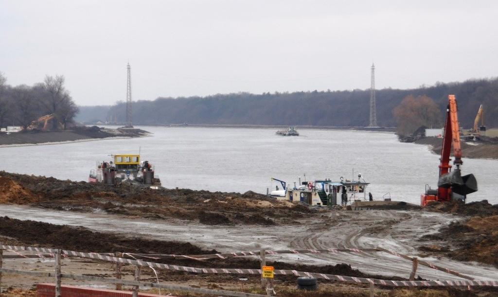
11 Main factors determining the influence of the Investment on the WB quality: Changes in the cross-section and longitudinal profile of the river, namely - widening and dredging of the river bed, profiling and reinforcement of the banks as well as partially of the river bottom, Reconstruction of hydraulic structures, Influence related to the works in the river bed and in the embankment area (at construction stage).
12 The total length of the section of the river subjected to the Investment within the scope of the linear WB Odra within the boundaries of Wrocław amounts to m, tantamount to 68.6% of the WB. In addition, the section of the river o the length 460 m is within the scope of WB Odra from the boundaries of Wrocław to Wały Śląskie. - 3% of WB Odra from the boundaries Wrocław to Wały Śląskie. In addition, the Investment is executed within the scope of the channels and Odra River arms with the total length of approx m, excluded from the linear length of WB Odra within the boundaries of Wrocław. These structures are the habitats for water organisms and have been considered in the analysis of the impact of the Investment on the aspects of surface water quality.
13 Due to the realisation of the Investment: the biological state of water quality elements (ichthyofauna, macrozoobenthos, and macrophytes) will deteriorate for the period of at least 3-5 years (the period of the realisation of the Investment and a few growing seasons after the termination of the works); uniformization of the river bed and riverside along the section (morphological conditions); not impact the hydrological regime, although it will positively influence the morphological continuity of the river; the impact on physicochemical elements will be limited only to the stage of the works, and due to the use of specific work technologies, it is not expected that the threshold will be crossed in this respect. derogation from Art of WFD Art 4.7 exemptions
14 Althought It should be emphasised that in the course of analyses it was found that the level of reconstruction of morphological conditions in the river bed and area after the realisation of the Investment will allow for the functioning of biological elements the level of which will be at least the same as before the realisation of the Investment, provided that there are no other conditions that are not related to the realisation of the Investment.
15 Analysis of the evidence of art WFD indicates that the Investment meets the specific conditions required by those provisions of the WFD. This means that the implementation of the Investment s is not an infringement of the provisions of the WFD in terms of compliance with Art. 4.1 in conjunction with Art RDW. For example

16 Ecological island
17


18 Fish passes
19 Alternatives Variant no. 1 ( technical one) Presented for the Consultant s Environmental Team assessment. Variant no. 2 ( environmental one) Developed during the works on the EIR through environmental profiling of variant no. 1 (inclusion of measures reducing adverse impact)
20 Development consent Project of the class listed in Annex II, Environmental impacts report: 2010, Decision on environmental conditions: december 2010, Several minimizing measures, which are components of the selected variant no. 2 The decision had the immediate implementation status, was issued after obtaining opinions of health protection authorities, i.e. sanitary inspectorates, WWF Poland was a party of proceedings, The developer organized an opened public debate for the society. Building permits:
21 Environmental management plan According to classification given in item 8 of operational policy OP 4.01 of the World Bank, the ORFPP is an A category project, i.e. it may exert a significant adverse impact on the environment and therefore: requires undertaking an environmental impact assessment (EIA) and development of the environmental management plan (EMP). In conformity with World Bank guidelines, the Environmental Management Plan is a tool determining: a) set of measures for elimination or limitation of adverse impact of the project on environment, which shall be implemented during realization of the project and after its completion; b) necessary actions for effective implementation of these measures.


22 Contract 3.1 Task 4 (stopień Różanka)


23 Contract 3.2 Task 6


24 Contract 4.2
25 Thank you

26 26 For info or further questions on this presentation, please contact: Massimo Marra JASPERS Networking and Competence Center Senior Officer ph:
ANNEX TO ENVIRONMENTAL MANAGEMENT PLAN for Odra River Basin Flood Protection Project Component B Modernization of Wroclaw Floodway System
 ANNEX TO ENVIRONMENTAL MANAGEMENT PLAN for Odra River Basin Flood Protection Project Component B Modernization of Wroclaw Floodway System WORKS CONTRACT Odra Widawa Weir to the railway bridge (Krzywoustego
Reconnecting rivers in urban areas; challenges and considerations
 River Forth Fisheries Trust Reconnecting rivers in urban areas; challenges and considerations RAFTS-ASFB conference 2016 Currently five morphology project sites in the Forth District with three informing
E1139 Volume 1 ODRA RIVER BASIN FLOOD PROTECTION PROJECT ENVIRONMENTAL ASSESSMENT. Executive Summary. RZGW Gliwice DZMiUW
 Public Disclosure Authorized Public Disclosure Authorized Public Disclosure Authorized Public Disclosure Authorized Government of Poland Ministry of Interior and Administration Office for Natural Disasters
ENVIRONMENTAL ISSUES and TEN-T PROJECTS Key elements for a sustainable network development
 ENVIRONMENTAL ISSUES and TEN-T PROJECTS Key elements for a sustainable network development TEN-T Project Management Workshop 2010 George Kremlis DG ENV B4, European Commission 13 January 2010 Environmental
JASPERS lessons learnt. Adina Relicovschi, EIA Coordinator
 JASPERS lessons learnt Adina Relicovschi, EIA Coordinator Current portfolio Key issues Some 450 assignments in the Action Plans 2011, it is expected that JASPERS will complete about 100 Assignments in
River Restoration in Urban Areas. Petra Podraza
 River Restoration in Urban Areas Petra Podraza 1 Rivers for the Life of Towns 2007 Main Problems in Urban Rivers water quality discharge volume (floods and peak flow condition) technical constructed river
Lower Don River West Remedial Flood Protection Project TABLE OF CONTENTS. Page. Executive Summary
 TABLE OF CONTENTS Page Executive Summary 1.0 INTRODUCTION...1-1 1.1 Purpose of the Undertaking...1-1 1.2 Study Area Description...1-1 1.3 Description of the Undertaking...1-1 1.4 Rationale for the Undertaking...1-2
Cost 24.1m Benefit Cost Ratio: Potential Measures. A2 - Verdant Place Steps and Crèche. A5 - Star Rovers to Athlunkard Boat Club
 Introduction Limerick City and County Council has appointed the Arup JBA team to assess, develop and design a sustainable flood relief scheme for King s Island. This is our third public consultation event.
RURAL TRANSPORT TRAINING MATERIALS
 RURAL TRANSPORT TRAINING MATERIALS Module 5: Social and Environmental Issues Environmental impact assessment: Mkuze river crossing to Phelendaba, South Africa Session: 5.4 Part 2 Case Study Presentation:
THE ENVIRONMENTAL PROTECTION IN THE URBANISTICPLANNING AND LAND DEVELOPMENT IN EUROPEAN UNION LAW
 THE ENVIRONMENTAL PROTECTION IN THE URBANISTICPLANNING AND LAND DEVELOPMENT IN EUROPEAN UNION LAW The answes must be sent, imperatively in English or in French, before the 15th August 2011 to Ms. Anna
Circular L8/08 2 September Water Services Investment and Rural Water Programmes Protection of Natural Heritage and National Monuments
 Circular L8/08 2 September 2008 Water Services Investment and Rural Water Programmes Protection of Natural Heritage and National Monuments 1. The purpose of this Circular is to provide local authorities
River Restoration Practices:
 River Restoration Practices: Comparison of British Columbia and Central European Practices by David Matsubara and Dave Murray Add Map of North America VANCOUVER, Wa. Add Map of Vancouver OUTLINE Introduction
River Kleine Nete : Creating ecological flooding zones at recreation areas
 Stoffel Moeskops Lange Kievitstraat 111-113 bus 64 B-2018 ANTWERPEN T +32 3 205 81 25 s.moeskops@vmm.be River Kleine Nete : Creating ecological flooding zones at recreation areas \\\\\\\\\\\\\\\\\\\\\\\\\\\\\\\\\\\\\\\\\\\\\\\\\\\\\\\\\\\\\\\\\\\\\\\\\\\\\\\\\\\\\\\\\\\\\\\\\\\\\\\
Initial OPW Designation APSR AFRR IRR Co-ordinates Easting: Northing: Fluvial non-tidal Fluvial tidal Coastal
 Location: Athlone, Co. Westmeath (including townland in Roscommon) Unique ID: 260448 (from PFRA database) Initial OPW Designation APSR AFRR IRR Co-ordinates Easting: 205000 Northing: 239999 River / Catchment
Accumulating uncertainties: out of the blues?
 Accumulating uncertainties: out of the blues? International Water Conference Blues in the marshes - Water Authority Aa & Maas Den Bosch, 6-7-2017 Dr. André Jansen Senior Expert Hydro-ecology Unie van Bosgroepen
Arkadiusz Dołęga. Resume. This project is implemented through the CENTRAL EUROPE Programme co-financed by the ERDF.
 Analysis of needs of the residents of Wrocław and the surrounding municipalities on touristic products connected with open grounds in the Wrocław Metropolitan Area / WROM / Resume Arkadiusz Dołęga This
Conception of Syzran town development for the year of 2020 Russia
 Subscriber: Vervoorn, IHS Subscription Expires: 31-DEC-09 Conception of Syzran town development for the year of 2020 Russia Categories: Urban and Regional Planning: - community-based planning -cultural
Public participatory landscape design for Beigu Hill wetland
 Sustainable Development and Planning II, Vol. 2 1519 Public participatory landscape design for Beigu Hill wetland Y. Y. Wu, P. P. Li, C. D. Wu, C. Y. Li & Z. H. Sun The Institute of the Agricultural Engineering,
Step by step, the construction of a coherent overall restoration on the Seine estuary the role of GIP Seine-Aval
 Step by step, the construction of a coherent overall restoration on the Seine estuary the role of GIP Seine-Aval Stéphanie Moussard GIP Seine-Aval Seine estuary - France I-Introduction to the Seine estuary
6Natural. Environment Development Permit Guidelines
 6Natural Bylaw 2600-2016, being "Official Community Plan Bylaw, 2016" Schedule "A" CITY OF ABBOTSFORD OFFICIAL COMMUNITY PLAN Environment Development Permit Guidelines Part V - 6-1 Area Subdivision or
SUSTAINABLE URBAN MOBILITY PLAN TRAINING WORKSHOP. Module 1 Concept & Approach
 SUSTAINABLE URBAN MOBILITY PLAN TRAINING WORKSHOP Module 1 Concept & Approach Sustainable Urban Mobility Plans: What is a SUMP? Definition of Sustainable Urban Mobility Plan (SUMP): A Sustainable Urban
WILLIAM STREET STORM SEWER OUTFALL. PUBLIC INFORMATION CENTRE March 23, 2017
 WILLIAM STREET STORM SEWER OUTFALL Municipal Class Environmental Assessment PUBLIC INFORMATION CENTRE March 23, 2017 ACCESSIBILITY Under the Accessibility Standards 2015 for Customer Service Regulation
Northern Branch Corridor DEIS December 2011
 16 Floodplains 161 Chapter Overview 1611 Introduction The flowing chapter identifies floodplains found within the Northern Branch Corridor in accordance with Executive Order 11988, Floodplain Management
Environmental Impact Assessment (EIA) Training Session
 Training Session") Die Deutsche Gesellschaft für Internationale Zusammenarbeit (GIZ) GmbH Environmental Impact Assessment (EIA) Training Session By: Nedal Al Ouran (Ph.D.) AMMAN- November 6, 2013 Outline 1. Introduction
Die Deutsche Gesellschaft für Internationale Zusammenarbeit (GIZ) GmbH Environmental Impact Assessment (EIA) Training Session By: Nedal Al Ouran (Ph.D.) AMMAN- November 6, 2013 Outline 1. Introduction
Resolution XII NOTING also that with the increasingly rapid urbanization, wetlands are being threatened in two principle ways:
 12 th Meeting of the Conference of the Parties to the Convention on Wetlands (Ramsar, Iran, 1971) Punta del Este, Uruguay, 1-9 June 2015 Resolution XII.10 Wetland City 1 Accreditation of the Ramsar Convention
South Bismarck Watershed Model Update and Stormwater Improvement Project
 Preliminary Engineering Report Bismarck Tribune South Bismarck Watershed Model Update and Stormwater Improvement Project City of Bismarck, ND January 2017 14.105.0046 1.0 Executive Summary The focus of
THE SEINE- SCHELDT PROJECT Design & Build Harelbeke. ir. Ellen Maes, project engineer SMART Rivers 2011, 15th of September 2011
 THE SEINE- SCHELDT PROJECT Design & Build Harelbeke ir. Ellen Maes, project engineer SMART Rivers 2011, 15th of September 2011 OVERVIEW Waterwegen en Zeekanaal NV Seine-Scheldt an inland navigation project
Rannoch 132 / 33 kv Substation Extension
 Who we are Scottish and Southern Energy Power Distribution is part of the SSE plc group of companies. We own, maintain and invest in the networks in the north of Scotland the electricity transmission network
The Napa River Flood Protection Project
 The Napa River Flood Protection Project Creating Flood Protection and Restoring Geomorphic and Biological Processes Jeremy Sarrow, Napa County Flood Control & Water Conservation District June 2, 2014.
Draft Resolution XII.10
 12 th Meeting of the Conference of the Parties to the Convention on Wetlands (Ramsar, Iran, 1971) Punta del Este, Uruguay, 1-9 June 2015 Ramsar COP12 DR10, Rev. 2 21:45, 8 June Draft Resolution XII.10
Regional Context Statement
 Regional Context Statement REGIONAL CONTEXT STATEMENT 3. REGIONAL CONTEXT STATEMENT In 1995, the Provincial Government passed into law the Growth Strategies Act. The purpose of this provincial initiative
Proposed Variation to the Midleton Town Development Plan 2013
 Volume 1 Proposed Variation to the Midleton Town Development Plan 2013 Vacant Site Levy-Residential and Regeneration Areas Inclusion of new text and objective in relation to the Vacant Site Levy and Regeneration
POSSIBILITIES OF THE APPLICATION OF MAT GEOCOMPOSITES AND SPATIAL CELLULAR SYSTEMS IN THE CONSTRUCTION AND MODERNISATION OF EMBANKMENTS
 Henryk Orzeszyna, PhD., Eng. Daniel Garlikowski, PhD., Eng. Jolanta Dąbrowska, PhD., Eng. Andrzej Pawłowski, PhD., Eng. Krzysztof Lejcuś, PhD Institute of Environmental Engineering, Wroclaw University
DOCUMENTATION OF CONSTRUCTION S ENVIRONMENTAL IMPACT ASSESSMENT R6 JENIŠOV KAMENNÝ DVŮR
 EVERNIA s.r.o. DOCUMENTATION OF CONSTRUCTION S ENVIRONMENTAL IMPACT ASSESSMENT R6 JENIŠOV KAMENNÝ DVŮR Responsible researcher: Illegible signature RNDr. Petr Anděl, CSc. Professional Competence Certificate
Draft Rhode Island Stormwater Design and Installation Standards Manual
 Draft Rhode Island Stormwater Design and Installation Standards Manual Summary The May 2009 Public Review Draft version of the RI Stormwater Design and Installation Standards Manual consists of approximately
HRA PLANNING Chartered Town Planning and Environmental Consultants
 HRA PLANNING Chartered Town Planning and Environmental Consultants Screening Statement for the Purposes of Determining the need for Appropriate Assessment Proposed development of 74 no. residential units
Unique ID: (from PFRA database) Location: Birr, Co. Offaly. Stage 1: Desktop Review
 Location: Birr, Co. Offaly. Stage 1: Desktop Review") Location: Birr, Co. Offaly Unique ID: 250410 (from PFRA database) Initial OPW Designation APSR AFRR IRR Co-ordinates Easting: 206,007 Northing: 204,990 River / Catchment / Sub-catchment Camcor River /
Location: Birr, Co. Offaly Unique ID: 250410 (from PFRA database) Initial OPW Designation APSR AFRR IRR Co-ordinates Easting: 206,007 Northing: 204,990 River / Catchment / Sub-catchment Camcor River /
RECREATION AND OPEN SPACE ELEMENT GOALS, OBJECTIVES, AND POLICIES
 RECREATION AND OPEN SPACE ELEMENT GOALS, OBJECTIVES, AND POLICIES Goal 7 To provide park facilities, recreation programs, and open space resources that are safe, adequate, and accessible to all City residents,
3. Are there any projects exempt from the definition of Regulated Projects?
 STORMWATER REQUIREMENTS: OVERVIEW OF PROVISION C.3 Background: On October 14, 2009, the Regional Water Quality Control Board, San Francisco Bay Region, issued a municipal regional stormwater permit (MRP)
APPROPRIATE ASSESSMENT SCREENING IN ACCORDANCE WITH THE REQUIREMENTS OF ARTICLE 6(3) OF THE EU HABITATS DIRECTIVE FOR THE PROPOSED VARIATION OF THE
 OF THE EU HABITATS DIRECTIVE FOR THE PROPOSED VARIATION OF THE") APPROPRIATE ASSESSMENT SCREENING IN ACCORDANCE WITH THE REQUIREMENTS OF ARTICLE 6(3) OF THE EU HABITATS DIRECTIVE FOR THE PROPOSED VARIATION OF THE DUBLIN CITY DEVELOPMENT PLAN 2011-2017 RANELAGH AVENUE,
APPROPRIATE ASSESSMENT SCREENING IN ACCORDANCE WITH THE REQUIREMENTS OF ARTICLE 6(3) OF THE EU HABITATS DIRECTIVE FOR THE PROPOSED VARIATION OF THE DUBLIN CITY DEVELOPMENT PLAN 2011-2017 RANELAGH AVENUE,
Review of the Environmental Impact Assessment (Agriculture) (Wales) Regulations 2007
 (Wales) Regulations 2007") Review of the Environmental Impact Assessment (Agriculture) (Wales) Regulations 2007 Consultation response form Q1. Do you agree with the proposal to add a definition of semi-natural land to the EIA regulations?
Review of the Environmental Impact Assessment (Agriculture) (Wales) Regulations 2007 Consultation response form Q1. Do you agree with the proposal to add a definition of semi-natural land to the EIA regulations?
Table of Contents G.1.a Water Resources - Surface Water - Drainage
 Table of Contents G.1.a Water Resources - Surface Water - Drainage 1. INTRODUCTION... 1335 2. ENVIRONMENTAL SETTING... 1335 a. Regional Hydrology... 1335 b. Local Hydrology... 1337 c. On-site Hydrology...
Shoreline Master Program Town of La Conner, Washington
 Shoreline Master Program Town of La Conner, Washington Department of Ecology approval effective Adopted September 24, 2013 by Town of La Conner Ordinance No.1106 Amended May 13, 2014 by Town of La Conner
EXECUTIVE SUMMARY. Introduction
 Introduction EXECUTIVE SUMMARY The Urban Service Area Fort McMurray (hereafter referred to as the Urban Service Area) is currently experiencing a variety of development pressures. Unprecedented population
APPENDIX K WINDSOR OFFICIAL PLAN
 CEAA ENVIRONMENTAL ENVIRONMENTAL IMPACT ASSESSMENT AMBASSADOR BRIDGE ENHANCEMENT PROJECT Replacement Span and Plaza Expansion APPENDIX K WINDSOR OFFICIAL PLAN Avalon Consulting Professionals of Ontario,
NYC DEP s Approach to Flood Mitigation: The Local Flood Analysis (LFA) Process
 Process") NYC DEP s Approach to Flood Mitigation: The Local Flood Analysis (LFA) Process Milone & MacBroom, Inc. Jenabay Sezen, EIT Connecticut Association of Floodplain Managers October 25, 2016 Agenda Introduction
NYC DEP s Approach to Flood Mitigation: The Local Flood Analysis (LFA) Process Milone & MacBroom, Inc. Jenabay Sezen, EIT Connecticut Association of Floodplain Managers October 25, 2016 Agenda Introduction
OFFICIAL PLAN FOR THE TOWN OF NEW TECUMSETH
 OFFICIAL PLAN FOR THE TOWN OF NEW TECUMSETH Approved by Simcoe County- March 10, 2010 TABLE OF CONTENTS PAGE# 1.0 TITLE AND COMPONENTS... 5 2.0 INTRODUCTION... 6 2.1 Purpose... 6 2.2 Organization of the
Slide 1. Slide 2 Instructor. Slide 3. NFPA 25 The Owner s Manual. Roles & Responsibilities DISCLAIMER
 Slide 1 NFPA 25 The Owner s Manual Roles & Responsibilities Presented by: Bob Caputo Slide 2 Instructor Bob is the Executive Vice President of Compliance Solutions with Telgian Corporation. He is the Chairman
Presentation to Parks and Open Space Advisory. Committee September 22, 2016
 Flood Planning & Preliminary Design Services for South St. Vrain Creek Restoration at Hall Ranch Presentation to Parks and Open Space Advisory Prepared for: Boulder County, Colorado Committee September
Using AutoCAD Civil 3D and ESRI ArcGIS to meet LEED-ND (Neighborhood Development) Requirements NDIA O Brien & Gere. All Rights Reserved.
 Requirements NDIA O Brien & Gere. All Rights Reserved.") Using AutoCAD Civil 3D and ESRI ArcGIS to meet LEED-ND (Neighborhood Development) Requirements NDIA 12457 1 Using AutoCAD Civil 3D and ESRI ArcGIS to meet LEED-ND (Neighborhood Development) Requirements
Using AutoCAD Civil 3D and ESRI ArcGIS to meet LEED-ND (Neighborhood Development) Requirements NDIA 12457 1 Using AutoCAD Civil 3D and ESRI ArcGIS to meet LEED-ND (Neighborhood Development) Requirements
Meeting Agenda. City of Guelph. River Systems Advisory Committee. Agenda Items. Item 1, 2 and 3. Item 4 Ward to Downtown Pedestrian Bridge
 Meeting Agenda City of Guelph River Systems Advisory Committee September 19, 2018 City Hall, Meeting Room B From 4:00 to 6:00 p.m. Meeting Chair: Mariette Pushkar Agenda Items Welcome to all Item 1, 2
15.0. Spatial Environmental Planning
 15.0 Spatial Environmental Planning 15.1 Spatial Environmental Planning The Spatial Environmental Planning Programme that was conceived in 1995 aims at ensuring protection of environmental resources while
DRAFT SCOPE FOR THE DRAFT ENVIRONMENTAL IMPACT STATEMENT FOR HUDSON HIGHLANDS RESERVE TOWN OF PHILIPSTOWN, NEW YORK June 5, 2018
 DRAFT SCOPE FOR THE DRAFT ENVIRONMENTAL IMPACT STATEMENT FOR HUDSON HIGHLANDS RESERVE TOWN OF PHILIPSTOWN, NEW YORK June 5, 2018 Project Name: Project Location SEQRA Classification of Project: Lead Agency:
Public Information Centre No. 1 King-Vaughan Road Bridge Replacement Municipal Class Environmental Assessment City of Vaughan
 Public Information Centre No. 1 King-Vaughan Road Bridge Replacement Municipal Class Environmental Assessment City of Vaughan Date: April 7, 2016 Location: Al Palladini Community Centre, Meeting Room #1
AECOM Wolverhampton City Centre Metro Extension Environmental Impact Assessment Scoping Report 64
 AECOM Wolverhampton City Centre Metro Extension Environmental Impact Assessment Scoping Report 64 14 Conclusions It can be concluded from the scoping report that the following topics should be scoped in
Checklists. Project Name: Location: File Number: Date of Submittal: Reviewer: Date: Applicant: Contact Name: Phone Number:
 Applicant: Contact Name: Phone Number: Email: Project Name: Location: File Number: Date of Submittal: Reviewer: Date: Concept Plan Requirements: I. General Project Information 1. Address or parcel number
Lake O the Pines Master Plan Revision Public Information Meeting April 25 & 27, 2017
 Lake O the Pines Master Plan Revision Public Information Meeting April 25 & 27, 2017 Presented By Matthew Like, Lake Manager U.S. Army Corps of Engineers Fort Worth District US Army Corps of Engineers
Ballincollig Carrigaline Municipal District
 Ballincollig Carrigaline Municipal District Local Area Plan 21 st August 2017 VOLUME THREE Map Browser 3 Map Browser Volume 3 Map Browser List of maps available to view on the Local Area Plan Map Browser:
Slum Upgrading in Brazil during the 1990s: an evaluation using Census data
 Slum Upgrading in Brazil during the 1990s: an evaluation using Census data Rute Imanishi Rodrigues rute@ipea.gov.br Setsu Kanto setsukanto@hotmail.com Paper presented at the World Bank Fourth Urban Research
OFFICE CONSOLIDATION SECONDARY PLAN AREA 22 THE BRAMALEA SOUTH INDUSTRIAL SECONDARY PLAN
 OFFICE CONSOLIDATION SECONDARY PLAN AREA 22 THE BRAMALEA SOUTH INDUSTRIAL SECONDARY PLAN November 2010 EXPLANATORY NOTES (Secondary Plan Area 22) General (pertaining to all secondary plan office consolidations)
T O W N O F H I G H R I V E R
 T O W N O F H I G H R I V E R o p e n s p a c e p l a n The Town of High River, 30 minutes South of Calgary, still retains much of its distinctive small town character and provides residents with a high
Natomas Joint Vision Open Space Plan
 Natomas Joint Vision Open Space Plan First Workshop series The City of Sacramento The County of Sacramento LAFCo ERA Economic Research Associates EIP Associates a Division of PBS & J Natomas Joint Vision
 Skipton Flood Alleviation Scheme Environmental Statement We are the Environment Agency. We protect and improve the environment and make it a better place for people and wildlife. We operate at the place
Former North Works, Lickey Road, Longbridge, Birmingham
 Committee Date: 14/11/2013 Application Number: 2013/06431/PA Accepted: 27/08/2013 Application Type: Full Planning Target Date: 26/11/2013 Ward: Longbridge Former North Works, Lickey Road, Longbridge, Birmingham
ORDINANCE NO WHEREAS, a primary opportunity identified in the Plan is to Re-Connect the Uncompahgre River:
 ORDINANCE NO. 17 - AN ORDINANCE OF THE TOWN OF RIDGWAY, COLORADO AMENDING THE OFFICIAL ZONING MAP TO PROVIDE FOR THE UNCOMPAHGRE RIVER OVERLAY DISTRICT AND CREATING RIVER CORRIDOR DEVELOPMENT REGULATIONS.
Unique ID: (from PFRA database) Location: Tralee, Co. Kerry. Stage 1: Desktop Review
 Location: Tralee, Co. Kerry. Stage 1: Desktop Review") Location: Tralee, Co. Kerry Unique ID: 230361 (from PFRA database) Initial OPW Designation APSR AFRR IRR Co-ordinates Easting: 82750 Northing: 114000 River / Catchment / Sub-catchment Lee River & Big River/
Location: Tralee, Co. Kerry Unique ID: 230361 (from PFRA database) Initial OPW Designation APSR AFRR IRR Co-ordinates Easting: 82750 Northing: 114000 River / Catchment / Sub-catchment Lee River & Big River/
Landscape management for leisure and recreation - integrated water management at the example of the River Mur
 Landscape management for leisure and recreation - integrated water management at the example of the River Mur DI Oliver Rathschueler DI Hans-Jörg Raderbauer - freiland Overview Landscape management in
Leading environmental solutions...
 Leading environmental solutions... About Us Australian Wetlands Consulting (AWC) is a multi-award winning environmental design and consulting company committed to creating a better environment through
Aebhin Cawley (Scott Cawley Ltd.) Appropriate Assessment in Practice A Consultant s Perspective
 Appropriate Assessment in Practice A Consultant s Perspective") Aebhin Cawley (Scott Cawley Ltd.) Appropriate Assessment in Practice A Consultant s Perspective Natura 2000 sites in Ireland 423 SACs (including 4 Marine) 153 SPAs Habitats Directive Article 6 (3) Any
Aebhin Cawley (Scott Cawley Ltd.) Appropriate Assessment in Practice A Consultant s Perspective Natura 2000 sites in Ireland 423 SACs (including 4 Marine) 153 SPAs Habitats Directive Article 6 (3) Any
Fluvial non-tidal Fluvial tidal Coastal. PFRA database comments (in italics): OPW comments Minor flooding of residents on golf links road
: OPW comments Minor flooding of residents on golf links road") Location: Charleville, Co. Cork Unique ID: 240375 (from PFRA database) Initial OPW Designation APSR AFRR IRR Co-ordinates Easting: 152250 Northing: 122500 River / Catchment / Sub-catchment Glen River /
Location: Charleville, Co. Cork Unique ID: 240375 (from PFRA database) Initial OPW Designation APSR AFRR IRR Co-ordinates Easting: 152250 Northing: 122500 River / Catchment / Sub-catchment Glen River /
Montana Stream Permitting
 Montana Stream Permitting A Guide for Conservation District Supervisors and Others Conservation Districts Bureau Montana Department of Natural Resources and Conservation June 2001 CONTRIBUTORS Committee
Urban Stormwater Management
 State Regulations and Sustainable Infrastructure April 16, 2011 Urban Stormwater Management Drivers Ecosystem Services LID and Light Imprint New Urbanism Comments MD Stormwater Regulations Larry S. Coffman
M7 Naas to Newbridge Bypass Upgrade Scheme. Landscape and Visual Impact Assessment Brief of Evidence
 M7 Naas to Newbridge Bypass Upgrade Scheme Landscape and Visual Impact Assessment Brief of Evidence Presented by Richard Butler, Cunnane Stratton Reynolds Landscape Architect: BL Arch (University of Pretoria,
UNCLASSIFIED. Risk of Flooding from Reservoirs - Severn River Basin District
 UNCLASSIFIED Flood Risk Maps Risk of Flooding from Reservoirs - Severn Why have we produced these maps what can they be used for? Under the Flood Risk Regulations Natural Resources Wales have worked in
Development Permit Application Form. Property Owner Information as Registered on Legal Title Property Owner Name: Phone:
 Development Application Requirements 1 1926 Tsawwassen Drive Tel: 604-943-2112 Tsawwassen, BC V4M 4G2 www.tsawwassenfirstnation.com Canada Development Permit Application Form Name of Applicant: Address:
Balance (sustainable) land use and management of protected areas in Lithuania
 land use and management of protected areas in Lithuania") Balance (sustainable) land use and management of protected areas in Lithuania Kastytis Gedminas State Service for Protected Areas under the Ministry of Environment of Lithuania Living Lakes. Eastern Europe
Balance (sustainable) land use and management of protected areas in Lithuania Kastytis Gedminas State Service for Protected Areas under the Ministry of Environment of Lithuania Living Lakes. Eastern Europe
STREAM BANK STABILIZATION THORPS MORTIMER RECREATION AREA Grandfather Ranger District SITE LOCATION & DRAINAGE AREA
 STREAM BANK STABILIZATION THORPS CREEK @ MORTIMER RECREATION AREA SITE LOCATION & DRAINAGE AREA SITE LOCATION Drainage Area = 1.14 sq. miles STREAM BANK STABILIZATION THORPS CREEK @ MORTIMER RECREATION
17 NOVEMBER 2015 PLANNING COMMITTEE. on Cttee Day: 73/73. Land To The Rear Of Brook Farm Rickford Worplesdon, Bagshot Road, Woking, Surrey
 5l 14/0218 Reg d: 27.06.14 Expires:20.11.15 Ward: BR Nei. 17.07.14 BVPI Con. Target: 18 Exp: Number of Weeks On Target? on Cttee Day: 73/73 Y LOCATION: PROPOSAL: TYPE: Land To The Rear Of Brook Farm Rickford
New techniques for urban river rehabilitation
 New techniques for urban river rehabilitation (WP8) URBEM Urban River Basin Enhancement Methods New techniques for urban river rehabilitation Methodology Work Package 8 LNEC João Rocha Elsa Alves EVK-CT-2002-00082
PETERHEAD PORT AUTHORITY ENVIRONMENTAL STATEMENT. Non-Technical Document
 PETERHEAD PORT AUTHORITY ENVIRONMENTAL STATEMENT Document No 5357/04 Rev FINAL Issued January 2015 West Pier Peterhead Aberdeen AB42 1DW Niras Fraenkel Ltd Merlin House Mossland Road Hillington Park Glasgow
INTER-AGENCY COORDINATION MEETING
 Virginia Department of Transportation INTER-AGENCY COORDINATION MEETING Joint Permit Application DEQ COE VMRC I. VDOT PROJECT INFORMATION PERMIT #: PRE-APP#: Route: VDOT Project Number: City/County: Contract
CAIRNGORMS NATIONAL PARK AUTHORITY
 DEVELOPMENT PROPOSED: Removal of Gravel Embankments at Allt an t-slugain, Invercauld Estate, Braemar REFERENCE: 2016/0082/DET APPLICANT: Scottish Natural Heritage DATE CALLED-IN: 5 th April 2016 RECOMMENDATION:
JOINT PUBLIC NOTICE. 26 June United States Army Corps of Engineers State of Louisiana
 JOINT PUBLIC NOTICE 26 June 2017 United States Army Corps of Engineers State of Louisiana New Orleans District Department of Environmental Quality Regulatory Branch Office of Environmental Services 7400
Table of Contents. 3. Name and Location of Natura 2000 sites Description of the Project or Plan 5
 Table of Contents PAGE NUMBER 1. Introduction 1 2. Name of Project or Plan 1 3. Name and Location of Natura 2000 sites 1 4. Description of the Project or Plan 5 5. Is this Project or Plan directly connected
Kevin M. Rampe, President -- Lower Manhattan Development Corporation
 For Internal Use Only: Date Received: WRP no. DOS no. NEW YORK CITY WATERFRONT REVITALIZATION PROGRAM Consistency Assessment Form Proposed actions that are subject to CEQR, ULURP or other local, state
Draft Municipal District Local Area Plans. Map Browser. VOLUME THREE Map Browser th November 2016
 Draft Municipal District Local Area Plans Map Browser 16 th November 2016 VOLUME THREE Map Browser 3 Draft Municipal District Local Area Plans How to make a Submission The Draft Municipal District Local
Highlands Region Stormwater Management Program Guidance
 DRAFT Highlands Region Stormwater Management Program Guidance Release Date: January 2016 Abstract This guidance document provides an overview of the Highlands Stormwater Management Program. It is intended
Plan for City Planning Areas) and on this basis provide for detailed individual city plans(see Section 1-1 of Chapter 3 at page 33). Master Plan for C
 and on this basis provide for detailed individual city plans(see Section 1-1 of Chapter 3 at page 33). Master Plan for C") Section 2 City Planning Act The City Planning Act was promulgated in June 1968 and enforced in June 1969 under the basic principles that healthy and cultural urban lifestyles and functional urban activities
Section 2 City Planning Act The City Planning Act was promulgated in June 1968 and enforced in June 1969 under the basic principles that healthy and cultural urban lifestyles and functional urban activities
Canal & River Trust response to the Consultation on the Working Draft Environmental Impact Assessment Report
 High Speed Two Phase 2a: West Midlands to Crewe Response to Working Draft Environmental Impact Assessment Report Please find below the response of the Canal & River Trust. The Trust is the guardian of
Procurement Plan dated August 11, 2017
 Public Disclosure Authorized I. General Procurement Plan dated, ODRA-VISTULA FLOOD MANAGEMENT PROJECT Public Disclosure Authorized Public Disclosure Authorized. Data of General Project information: 2.
AMENDMENTS. Date Effective. Amendment No. Council. DCP 14 Davidson St, Greenacre Page 2
 AMENDMENTS Amendment No. Description Adopted by Council Date Effective DCP 14 Davidson St, Greenacre Page 2 TABLE OF CONTENTS 1.0 INTRODUCTION... 4 1.1 NAME OF THIS PLAN... 4 1.2 COMMENCEMENT OF DEVELOPMENT
Is a Riparian Restoration Still Viable After 100-year Storm Events Alter the Original Design?
 Is a Riparian Restoration Still Viable After 100-year Storm Events Alter the Original Design? Sarah Spear Cooke, Ph.D. Seattle, Washington Presentation Outline Introduction The site pre-restoration Restoration
Finger Lakes National Forest. Backbone Horse Camp Water Hydrant Project
 United States Department of Agriculture Forest Service February 2014 Backbone Horse Camp Water Hydrant Project Scoping Information Hector Ranger District Town of Lodi, Seneca County, New York For Information
North Branch of Cypress Creek Ecological Restoration: A Comprehensive Approach to Stream Restoration
 North Branch of Cypress Creek Ecological Restoration: A Comprehensive Approach to Stream Restoration Rocky Powell Clear Creeks Consulting, LLC Keith D. Tate, P.E. BayLand Consultants & Designers, Inc.
Holnicote Multi-Objective Flood Demonstration Project Steve Rose (JBA)
") Holnicote Multi-Objective Flood Demonstration Project Steve Rose (JBA) Pete Worrall (PAA), Gene Hammond (PAA), Nigel Hester (NT) & Zdenka Rosolova (JBA) Introduction Objectives Identify landscape scale
Holnicote Multi-Objective Flood Demonstration Project Steve Rose (JBA) Pete Worrall (PAA), Gene Hammond (PAA), Nigel Hester (NT) & Zdenka Rosolova (JBA) Introduction Objectives Identify landscape scale
Local Action for Biodiversity in the Brussels Capital Region
 Urban Biodiversity: Local Solutions to Global Challenges Greenweek session 2.8, 3th June 2010 Local Action for Biodiversity in the Brussels Capital Region MACHTELD GRYSEELS MARIE-CELINE GODIN Brussels
10.14 ERRATA UPDATE SHEET 3
 Executive Committee Meeting Addendum #13/15 January 15, 2016 9:30 A.M. HEAD OFFICE, 101 EXCHANGE AVENUE, VAUGHAN Members: Maria Augimeri Michael Di Biase David Barrow Vincent Crisanti Glenn De Baeremaeker
Vaughan Metropolitan Centre (VMC) Black Creek Renewal CLASS ENVIRONMENTAL ASSESSMENT
 Black Creek Renewal CLASS ENVIRONMENTAL ASSESSMENT") PUBLIC INFORMATION CENTRE Vaughan Metropolitan Centre (VMC) Black Creek Renewal Wednesday, May 10, 2017 6:00 p.m. to 8:00 p.m. Add photo Project Management, Environmental Assessment, Stormwater Management
PUBLIC INFORMATION CENTRE Vaughan Metropolitan Centre (VMC) Black Creek Renewal Wednesday, May 10, 2017 6:00 p.m. to 8:00 p.m. Add photo Project Management, Environmental Assessment, Stormwater Management
Replacement Golf Course Facilities and Residential Development, Churston. Environmental Statement Non-Technical Summary
 Replacement Golf Course Facilities and Residential Development, Churston Environmental Statement Non-Technical Summary July 2011 Reproduced from the Ordnance Survey s map with the permission of the Controller
Goals and Strategies. Goals. Strategies. Long-term Beach and Shoreline Management Program
 Goals and Strategies Goals Long-term Beach and Shoreline Management Program Qualify for and Maintain Static-line Exception Qualify for and Maintain FEMA Engineered Beach Lockwoods Folly Inlet Management