NYC DEP s Approach to Flood Mitigation: The Local Flood Analysis (LFA) Process
|
|
|
- Paulina Hill
- 5 years ago
- Views:
Transcription


1 NYC DEP s Approach to Flood Mitigation: The Local Flood Analysis (LFA) Process Milone & MacBroom, Inc. Jenabay Sezen, EIT Connecticut Association of Floodplain Managers October 25, 2016
2 Agenda Introduction Scope of a Local Flood Analysis (LFA) Examples Lessons Learned
3 Agenda Introduction Where did the LFA concept come from? Why are LFAs needed? Intentions and goals of an LFA Scope of an LFA Examples Lessons Learned
4 What is an LFA? What is an LFA? A Local Flood Analysis, or LFA, is a New York City funded program developed at the request of West of Hudson New York City Watershed communities following flooding caused by Tropical Storms Irene and Lee in The program funds a two step process to: (1) conduct engineering analysis to determine the causes of flooding and evaluate mitigation options; and (2) undertake project design and implementation. What is the end product of an LFA? An engineering analysis of existing flooding conditions and feasible options to mitigate flooding moving forward, including sketches of the mitigation options, cost estimates, benefit cost analyses, and funding sources available.


5 Why LFA? Catskills towns have been devastated by flooding, resulting in extensive damage Critical infrastructure, businesses, and homes remain vulnerable Located within the New York City public water supply watershed LFA funding provides a unique opportunity to assess the watershed under current conditions and plan for the future Main Street in Phoenicia Along the Beaver Kill in Mt Tremper


6 The LFA Process Uniform but customizable Collect input from property owners, municipal officials, and others Build upon FEMA flood modeling and county hazard mitigation plan Identify and evaluate potential flood mitigation measures that protect water quality Assess flood relief alternatives through hydraulic modeling Refine alternatives through vetting of cost, feasibility, and public support Develop an implementation plan Lexington LFA Public Meeting Walton LFA Public Meeting

7 Why Third Brook? Flood Mitigation Strategies Channel Alteration Widening or realignment, creation of compound channel or bypass channel Floodplain Reclamation, creation, enhancement Bridges Removal or replacement


8 Why Third Brook? Flood Mitigation Strategies Sediment Management Sediment removal, stabilization of sources Individual Structures Floodproofing, elevation of structures, voluntary buy outs, relocations
9 Agenda Introduction Scope of an LFA Field assessment Hydrology and Hydraulics Flood Mitigation Alternatives Benefit Cost Analysis Examples Lessons Learned

10 Why Third Brook? Field Assessment Visual assessment of river channel and floodplain Bank and channel conditions Low lying structures Visual assessment of structures within project area Signs of past flooding Basement type Number of stories

11 Why Third Brook? Hydrology and Hydraulics Use FEMA HEC RAS modeling Update model based on field assessment Model flood mitigation alternatives
12 Why Third Brook? Flood Mitigation Alternatives Use HEC RAS modeling to investigate alternatives: Floodplain benches Raising and/or widening bridges Channel widening Bypass channel Dredging
13 Why Third Brook? Benefit Cost Analysis What is Benefit Cost Analysis (BCA)? Process of determining the Benefit Cost Ratio (BCR) A mitigation project cannot be funded by FEMA unless it has a BCR greater than 1.0 Benefits = Damages Avoided, units of $ Benefits over the life span must exceed project cost FEMA s BCA tool must be used

 s")


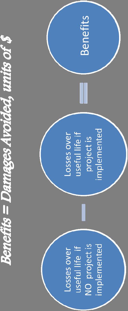

14 Benefit Cost Analysis Benefit Cost Analysis (BCA) Benefits and costs both have the unit of $
15 Agenda Introduction Scope of an LFA Examples Fleischmanns Walton Arkville Lessons Learned
16 Fleischmanns Specific Concerns Changes in FEMA mapping expansion of homes and businesses in the SFHA Some property owners have not been required to have flood insurance, but may be required to have it Flood insurance premiums are increasing as actuarial rates are phased in Property owners can make changes to their structures and utilities to reduce insurance premiums
17 Fleischmanns Specific Concerns Channelized sections of streams are located in the Village Berms, revetments, and walls are found along the streams in some locations Lack of connection to floodplain High flows are completely contained (unless overbank) and shear stresses are high, leading to erosion

18 Why Third Brook? Fleischmanns LFA Examples
19 Why Third Brook? Fleischmanns LFA Examples 10A Big Red Kill Combination 2 8B Combination (8B+1C+1D+4A) 9A Combination (9A+1B+4B) Alternative Cost Estimates Total Benefits* BCR BCR > 1? Creation of floodplain near park $268,000 $218, No Removal of outbuildings Includes 7A plus replacement of Route 28 Bridge Berm removal on right side of Big Red Kill and floodplain $2,134,000 $3,286, Yes creation on left side of Big Red Kill Includes 8B plus 4A and replacement of Main Street Bridge over Vly Creek $2,520,000 $2,402, No Removal of buildings Includes 4B plus creation of floodplain along Vly Creek south of Wagner Avenue Replacement of Wagner $3,693,000 $455, No Avenue Bridge Removal of buildings

20 Why Third Brook? Walton Specific Concerns Prevent floodwaters from diverting onto Delaware Street near Breakey Motors Reduce flooding at key businesses Reduce flood insurance premiums


21 Why Third Brook? Walton Alternatives Short Term A Long Term A


22 Why Third Brook? Walton Alternatives Short Term C Long Term C
23 Why Third Brook? Walton Alternatives Alternative Cost Estimates Total Benefits BCR > 1? ST A: Lower the floodplain south of Water Street Relocate Breaky Motors and restore site ST C: Lower the floodplain south of Water Street Relocate Breaky Motors and restore site Create/lower the fairgrounds floodplain LT A: Lower the floodplain south of Water Street Relocate Breaky Motors and restore site Extend the lowered floodplain through Dollar General Replace bridge with a 380 span and two piers Additional floodplain work related to bridge and connecting through to Water Street area LT C: Lower the floodplain south of Water Street Relocate Breaky Motors and restore site Extend the lowered floodplain through Dollar General Replace bridge with a 380 span and two piers Additional floodplain work related to bridge and connecting through to Water Street area Create/lower the fairgrounds floodplain $3.0M $3.8M Yes $8.1M $495.1M Yes $6.3M $5.3M No $14.9M $496.8M Yes


24 Arkville Specific Concerns Bridges cause flooding or make it worse Sediment transport management Periodic gravel harvesting Mitigate bank erosion Automated early warning system

25 Arkville Convert Culvert to Bypass Channel Existing Proposed Result: For the 10 Year flood, WSE decreases 1.4 ft to 2.9 ft in the circle Recommendation: Consider alone or in combination with other alternatives.

26 Arkville Combination Why 1: Third Bypass Channel Brook? with Floodplains Existing Proposed Result: For the 10 Year flood, WSE decreases 1.4 to 2.4 feet
27 Why Third Brook? Arkville Alternatives Alternative Cost Estimates Total Benefits BCR > 1? Floodplain Bench along Pavilion road $1,034,000 $1,614, Convert Culvert to Bypass Channel under Route 28 $2,533,000 $265, Route 28 Bridge Replacement $8,941,000 $2,153, Combination 1: Bypass Channel with Floodplains $3,615,000 $1,375, Combination 2: Route 28 Bridge Replacement with Floodplains $10,023,000 $3,199,
28 Agenda Introduction Scope of an LFA Examples Lessons Learned Involving a grass roots flood committee Benefits of a standardized process
29 Lessons Learned Involving a grass roots committee to guide the study leads to better consensus A standardized but customizable process allows results from different communities to be compared Streamlined funding Better FEMA grant applications
30 Ideas for Connecticut Identify a funding mechanism that recognizes the water quality benefits of flood mitigation 319/Impaired waters Other DEEP programs DPH Watershed protection Empower towns to work together to establish flood related commissions Strengthen Flood and Erosion Control Boards and their funding sources

31 Questions, Comments, or Thoughts?
Stream Corridor Management Plan
 Stream Corridor Management Plan A unified and comprehensive approach to protecting, restoring and managing the Upper Delaware River Graydon Dutcher Delaware County Soil and Water Conservation District
SAFARI Meeting Minutes July 10, 2015 AWSMP Office, 3130 State Route 28, Shokan, NY :00am to 12:00pm
 SAFARI Meeting Minutes July 10, 2015 AWSMP Office, 3130 State Route 28, Shokan, NY 12464 10:00am to 12:00pm Members Present: Brent Gotsch, CCEUC Mark Carabetta, MMI Don Brewer, Shandaken Planning Board
CRITICALFACILITIESASSESSMENT IN SOUTHEASTERN CONNECTICUT STRATEGIES FOR ALL HAZARDS RESILIENCE
 CRITICALFACILITIESASSESSMENT IN SOUTHEASTERN CONNECTICUT STRATEGIES FOR ALL HAZARDS RESILIENCE Presented by: David Murphy, P.E., CFM, Milone & MacBroom, Inc. October 25, 2017 Agenda Project Background
Lower Don River West Remedial Flood Protection Project TABLE OF CONTENTS. Page. Executive Summary
 TABLE OF CONTENTS Page Executive Summary 1.0 INTRODUCTION...1-1 1.1 Purpose of the Undertaking...1-1 1.2 Study Area Description...1-1 1.3 Description of the Undertaking...1-1 1.4 Rationale for the Undertaking...1-2
Libby Zemaitis October 18, 2017 Climate Outreach Specialist, NYS DEC Hudson River Estuary Program
 1 Supporting Hudson Riverfront communities as Climate-Adaptive Leaders Libby Zemaitis October 18, 2017 Climate Outreach Specialist, NYS DEC Hudson River Estuary Program The Hudson River Estuary Program
Presentation to Parks and Open Space Advisory. Committee September 22, 2016
 Flood Planning & Preliminary Design Services for South St. Vrain Creek Restoration at Hall Ranch Presentation to Parks and Open Space Advisory Prepared for: Boulder County, Colorado Committee September
7th Avenue Creek Master Plan Development Project. City of St. Charles, IL. IAFSM CONFERENCE March 14, 2018 MARKET
 7th Avenue Creek Master Plan Development Project MARKET City of St. Charles, IL IAFSM CONFERENCE March 14, 2018 7 TH AVENUE CREEK PROJECT AREA 2 2008 RAIN EVENT 3 RESIDENTIAL STRUCTURE FLOODING COMMERCIAL
Wallkill River. Floodplain Bench Project Phase 1. OCSWCD Kevin Sumner. October 2016 Orange County. Wendell Buckman
 Wallkill River Floodplain Bench Project Phase 1 October 2016 Orange County OCSWCD Kevin Sumner Wendell Buckman Introduction Location Define the Problem History Location MIDDLETOWN NEWBURGH PROJECT Location
Hazard Mitigation Planning. Association of New Jersey Environmental Commissions Workshop Edison, New Jersey October 20, 2012
 Hazard Mitigation Planning Association of New Jersey Environmental Commissions Workshop Edison, New Jersey October 20, 2012 Mitigation Planning NJ Hazard Mitigation Plan? What is the status of the HMP
Lower Meramec Multi-Jurisdictional Floodplain Management Plan Public Involvement (Results of Early Public Engagement) 27 June 2018
 27 June 2018") Lower Meramec Multi-Jurisdictional Floodplain Management Plan Public Involvement (Results of Early Public Engagement) 27 June 2018 Public Involvement Summary: The planning process includes opportunities
Lower Meramec Multi-Jurisdictional Floodplain Management Plan Public Involvement (Results of Early Public Engagement) 27 June 2018 Public Involvement Summary: The planning process includes opportunities
PLANNING COMMISSION Draft Minutes August 5, 2015
 PLANNING COMMISSION Draft Minutes August 5, 2015 Members Present: Members Absent: Others Present: Sally Miller, Paul Highberg, Marilyn Spaulding, Nick Scheu, Sam Segal, Susan Boston Keri Cole Ned Swanberg,
KYTC and NFIP: Bridging Floodplain Management and Design KAMM CONFERENCE AUGUST 25, 2015
 KYTC and NFIP: Bridging Floodplain Management and Design KAMM CONFERENCE AUGUST 25, 2015 KYTC STATEWIDE DRAINAGE DESIGN Provide Drainage Design Services on an as needed basis: Perform hydraulic analysis
Structural Project (stream daylighting) Property Protection (elevation) PREVENTION NATURAL RESOURCE PROTECTION STRUCTURAL PROJECTS PUBLIC EDUCATION
 Property Protection (elevation) PREVENTION NATURAL RESOURCE PROTECTION STRUCTURAL PROJECTS PUBLIC EDUCATION") NEW MITIGATION GOALS, STRATEGIES, ACTIONS PREVENTION STRUCTURAL PROJECTS NATURAL RESOURCE Structural Project (stream daylighting) PROPERTY PUBLIC EDUCATION EMERGENCY SERVICES Property Protection (elevation)
NEW MITIGATION GOALS, STRATEGIES, ACTIONS PREVENTION STRUCTURAL PROJECTS NATURAL RESOURCE Structural Project (stream daylighting) PROPERTY PUBLIC EDUCATION EMERGENCY SERVICES Property Protection (elevation)
Northern Branch Corridor DEIS December 2011
 16 Floodplains 161 Chapter Overview 1611 Introduction The flowing chapter identifies floodplains found within the Northern Branch Corridor in accordance with Executive Order 11988, Floodplain Management
Supporting Hudson Riverfront Communities as Climate-Adaptive Leaders. Libby Zemaitis November 17, 2017 NYS DEC Hudson River Estuary Program
 1 Supporting Hudson Riverfront Communities as Climate-Adaptive Leaders Libby Zemaitis November 17, 2017 NYS DEC Hudson River Estuary Program The Hudson River Estuary Program 2 Working to achieve 6 key
South Bismarck Watershed Model Update and Stormwater Improvement Project
 Preliminary Engineering Report Bismarck Tribune South Bismarck Watershed Model Update and Stormwater Improvement Project City of Bismarck, ND January 2017 14.105.0046 1.0 Executive Summary The focus of
Existing Conditions and Environmental Consequences Floodplains
 3.9 Environmental Consequences 3.8 3.8.1 WHAT ARE FLOODPLAINS? are low-lying areas adjacent to rivers, streams, and other waterbodies that are susceptible to inundation (flooding) during rain events. These
water resource specialists
 Vaughn Collins, PE, CFM, Northwest Hydraulic Consultants Brad Livingston, Oregon Department of Transportation Melissa Reich, North Coast Land Conservancy Location Necanicum River 75 sq mi watershed Active
Towards a Resilient Stormwater Future: Building Back from Hurricane Irene and Tropical Storm Lee. October 15, 2015 VUSP Symposium
 Towards a Resilient Stormwater Future: Building Back from Hurricane Irene and Tropical Storm Lee October 15, 2015 VUSP Symposium Russ Dudley, P.E., LEED AP Environmental Engineer Presentation Outline Impacts
Radnor Township. Factors affecting storm water issues.
 Radnor Township Factors affecting storm water issues. Climate Changes and Changing Weather Patterns Intensity of rains over the last 7 to 10 years. Larger number of smaller storms delivering greater amounts
Empowering Local Action for Coastal Resilience in Massachusetts. Bruce K. Carlisle MA Office of Coastal Zone Management
 Empowering Local Action for Coastal Resilience in Massachusetts Bruce K. Carlisle MA Office of Coastal Zone Management Context Coastal communities continue to face both chronic and acute storm surge, erosion,
City of Meriden Harbor Brook Flood Control Project Overview
 City of Meriden Harbor Brook Flood Control Project Overview Updated August 2013 OVERVIEW The center of Meriden, including the HUB site is the low point of the town which is ringed by basalt ridges. Running
Riparian Buffer on the Bushkill Creek. Policies
 Riparian Buffer on the Bushkill Creek Riparian buffers provide numerous benefits to landowners and the community by protecting groundwater recharge areas, providing flood control, providing stormwater
Stream Restoration: Working with Nature?
 Stream Restoration: Working with Nature? Greg Jennings, PhD, PE jenningsenv@gmail.com Ecosystem Restoration activities that initiate or accelerate the recovery of ecosystem health, integrity, and sustainability
Stream Restoration: Working with Nature? Greg Jennings, PhD, PE
 Stream Restoration: Working with Nature? Greg Jennings, PhD, PE jenningsenv@gmail.com Ecosystem Restoration activities that initiate or accelerate the recovery of ecosystem health, integrity, and sustainability
APPENDIX K WINDSOR OFFICIAL PLAN
 CEAA ENVIRONMENTAL ENVIRONMENTAL IMPACT ASSESSMENT AMBASSADOR BRIDGE ENHANCEMENT PROJECT Replacement Span and Plaza Expansion APPENDIX K WINDSOR OFFICIAL PLAN Avalon Consulting Professionals of Ontario,
Urban Stormwater Retrofit Program Highlights
 Urban Stormwater Retrofit Program Highlights Delaware Estuary Environmental Summit 2007 Prepared and Presented by: Liz Feinberg Project Funding: William Penn Foundation PA Coastal Zone Management Program
Planning for Staten. Habitat Restoration and Green Infrastructure. Island s North Shore
 Habitat Restoration and Green Infrastructure Planning for Staten Island s North Shore Community Board 1 March 1, 2018 NYC Parks Forestry, Horticulture, and Natural Resources Funded by the NYS Department
West London Dyke, April 1947 Flood. Forks of the Thames, July 2000 Flood. Source: UTRCA
 This Public Information Centre is the 1 st of 2. Its purpose is to inform the public and to receive input with regards to the West London Dyke Master Repair Plan. The following panels describe the history,
Planning for Historic/Cultural Resources Coastal Resiliency in Connecticut. Presented to CAFM s 3 rd Annual Conference
 Planning for Historic/Cultural Resources Coastal Resiliency in Connecticut Presented to CAFM s 3 rd Annual Conference October 25, 2016 Agenda Introduction and Project Overview Background Historic and Cultural
Preparing Hudson River Waterfronts for an Era of Rapid Sea Level Rise
 Preparing Hudson River Waterfronts for an Era of Rapid Sea Level Rise CITY OF KINGSTON TIDAL WATERFRONT FLOODING TASK FORCE Gregg Swanzey Director, Office of Economic Development & Strategic Partnerships,
City of East Point Comprehensive Floodplain Management Program
 City of East Point Comprehensive Floodplain Management GAFM 2012, 7 th Annual Technical Conference Reza Aral, CFM, CPESC (City of East Point, GA) Shayne Wood, P.E. (CDM Smith) March, 28, 2012 Agenda Overview
SOUTH FOX MEADOW STORMWATER IMPROVEMENT PROJECT
 VILLAGE OF SCARSDALE WESTCHESTER COUNTY, NEW YORK COMPREHENSIVE STORM WATER MANAGEMENT SOUTH FOX MEADOW STORMWATER IMPROVEMENT PROJECT In association with WESTCHESTER COUNTY FLOOD MITIGATION PROGRAM Rob
Planning and Zoning Commission
 Planning and Zoning Commission City of Derby Chairman Theodore J. Estwan, Jr., Steven A. Jalowiec David J. Rogers David Barboza II Richard A. Stankye Albert Misiewicz Glenn H. Stevens Raul Sanchez (Alternate)
Draft Rhode Island Stormwater Design and Installation Standards Manual
 Draft Rhode Island Stormwater Design and Installation Standards Manual Summary The May 2009 Public Review Draft version of the RI Stormwater Design and Installation Standards Manual consists of approximately
Floodplain Management Strategies in Forsyth County Georgia Association of Floodplain Management 7 th Annual Technical Conference March 2012
 Floodplain Management Strategies in Forsyth County Georgia Association of Floodplain Management 7 th Annual Technical Conference March 2012 Renee Hoge, P.E., CFM Forsyth County Department of Engineering
Appendix E Preliminary Location Hydraulic Study
 Appendix E Prepared for: State of Alaska Department of Transportation and Public Facilities Prepared by: HDR Alaska, Inc. 2525 C Street, Suite 305 Anchorage, Alaska 99503 February 2014 This page intentionally
Guiding Landowners in Stream Restoration. The Science, Practice & Art of Restoring Native Ecosystems 2015
 Guiding Landowners in Stream Restoration The Science, Practice & Art of Restoring Native Ecosystems 2015 January 24, 2015 Guiding Landowners in Stream Restoration January 24, 2015 Agenda 1Watershed Planning
Climate Smart Communities Green Infrastructure Case Studies
 New York State Water Resources Institute Climate Smart Communities Green Infrastructure Case Studies Emily Vail Hudson River Estuary Program NYS Department of Environmental Conservation Cornell University
Lincoln 270. City of Lincoln. Stormwater Management Plan. April 2, 2013
 Lincoln 270 City of Lincoln Stormwater Management Plan April 2, 2013 # 2005.48 Prepared By: Civil Engineering Solutions, Inc. 590 E Street Lincoln, Ca 95648 (916) 645 5700 1.0 Background: The project site
Welcome to the San Francisquito Creek Flood Protection, Ecosystem Restoration, and Recreation Project Upstream of Highway 101
 Welcome to the San Francisquito Creek Flood Protection, Ecosystem Restoration, and Recreation Project Upstream of Highway 101 Public Scoping Meeting June 6, 2013 Open House 7:00 7:15 Project Presentation
FURTHER TO EXECUTIVE COMMITTEE MEETING #11/12 To be held on Friday, January 11, 2013
 FURTHER TO EXECUTIVE COMMITTEE MEETING #11/12 To be held on Friday, January 11, 2013 FURTHER TO: Pages EX10. APPLICATION FOR PERMITS UNDER ONTARIO REGULATION 166/06 Development, Interference with Wetlands
Request for an Exception to the Napa County Road and Street Standards
 F Request for an Exception to the Napa County Road and Street Standards Shed Creek Winery Use Permit P16-327 and Use Permit Exception to the Conservation Regulations P17-178 Planning Commission Hearing
When planning stormwater management facilities, the following principles shall be applied where possible.
 2.0 Principles When planning stormwater management facilities, the following principles shall be applied where possible. 2.0.1 Drainage is a regional phenomenon that does not respect the boundaries between
Village of Forest Park. July 27, Sewer Separation Evaluation
 Village of Forest Park July 27, 2015 Sewer Separation Evaluation Presentation Overview Study Background Historic Nature of Forest Park Drainage Scale of Flooding Problem Forest Park Sewer System Background
LOUISIANA STATE UNIVERSITY COMPREHENSIVE & STRATEGIC CAMPUS MASTER PLAN. APPENDIX G - Stormwater Study Findings & Stormwater Solutions
 LOUISIANA STATE UNIVERSITY COMPREHENSIVE & STRATEGIC CAMPUS MASTER PLAN APPENDIX G - Stormwater Study Findings & Stormwater Solutions LSU: MP Narrative July 2017 3.5 Open Space Existing Conditions The
NAI Principles In Gwinnett County
 NAI Principles In Gwinnett County By Cornelius Ani, LSIT, CFM Contributors: Adena Fullard, P.E., CPSWQ Rudresh Bihalli, P.E., CFM Ken Kagy, P.E., CPESC, CPSWQ Ligia Negru, M. Sc., CFM Maja Radovic, CPESC,
Imperviousness & Runoff
 North Texas Alternative Futures Imperviousness & Runoff A key indicator for comparing alternative future scenarios This powerpoint presents: What is this key indicator? How do the alternative future scenarios
Poisoned Park? How Exide s Lead Contamination Risks Frisco s Grand Park
 Frisco City Hall has big plans to transform Stewart Creek into a Grand Park with lots of water features for kids to play in. Poisoned Park? How Exide s Lead Contamination Risks Frisco s Grand Park But
SOIL EROSION AND SEDIMENT CONTROL
 SOIL EROSION AND SEDIMENT CONTROL SECTION 1: AUTHORITY, TITLE AND PURPOSE 11. STATUTORY AUTHORIZATION This ordinance is adopted pursuant to the provisions of the Federal Water Pollution Control Act 86
TOWN OF BETHLEHEM MEETING SUMMARY LOCAL WATERFRONT REVITALIZATION PROGRAM UPDATE
 TOWN OF BETHLEHEM LOCAL WATERFRONT REVITALIZATION PROGRAM UPDATE MEETING SUMMARY Purpose: LWRP Update Public Workshop #3 Date and Time: October 24, 2017, 6:00 pm - 8:00 pm Location: Town Hall, 445 Delaware
Outfall Retrofit Feasibility Study
 Outfall Retrofit Feasibility Study 2013 APWA-NC SWM Conference September 16-17, 2013 Overview PWD history with outfall retrofits Project setting Review of screening factors and weighting scale QA/QC process
Key elements : Filter Strips must be designed within parameters required by the Fort Wayne s Development Standards/Criteria Manual.
 4.4. Filter Strips Filter Strips are densely vegetated lands that treat sheet flow storm water from adjacent pervious and impervious areas. They function by slowing runoff, trapping sediment and pollutants,
STREAM BANK STABILIZATION THORPS MORTIMER RECREATION AREA Grandfather Ranger District SITE LOCATION & DRAINAGE AREA
 STREAM BANK STABILIZATION THORPS CREEK @ MORTIMER RECREATION AREA SITE LOCATION & DRAINAGE AREA SITE LOCATION Drainage Area = 1.14 sq. miles STREAM BANK STABILIZATION THORPS CREEK @ MORTIMER RECREATION
Executive Office of Energy and Environmental Affairs Massachusetts Vulnerability Preparedness Program. June 6, 2018
 Executive Office of Energy and Environmental Affairs Massachusetts Vulnerability Preparedness Program June 6, 2018 Presentation Outline: 1. What Natural Hazards Impact Falmouth 2. Coastal Resiliency Efforts
Washington County, Maryland Division of Public Works Policy Manual
 Washington County, Maryland Division of Public Works Policy Manual Subject: Downstream Drainage Easement Category: Land Development Engineering Number: 7-4.1 Date: June 1, 2009 (effective) PURPOSE: The
URBANIZED STREAM CORRIDOR: COMMUNITY APPROACH TO ADDRESS EROSION
 URBANIZED STREAM CORRIDOR: COMMUNITY APPROACH TO ADDRESS EROSION Stephen Crawford, P.E., CFM Romin Khavari, P.E., CFM NCTCOG Public Works Roundup MAY 23, 2018 Today s Agenda Urbanized Stream Erosion Solving
MEMORANDUM. September 10, 2018
 September 10, 2018 MEMORANDUM TO: Chad Bird, City of Decorah FROM: Larry Weber and Dan Gilles, Iowa Flood Center, IIHR Hydroscience & Engineering COPY TO: Dana Werner, St. Paul District Corps of Engineers,
Chapter 1 GENERAL SOUTH DAKOTA DRAINAGE MANUAL
 Chapter 1 GENERAL SOUTH DAKOTA DRAINAGE MANUAL October 2011 Table of Contents Section Page 1.1 INTRODUCTION...1-1 1.2 BASIC APPROACH...1-2 1.3 FUNCTIONAL RESPONSIBILITIES...1-3 1.3.1 Office of Road Design...1-3
Please highlight flow chart where applicable and return with Form 2 and Form 3 (tab 1) to the City of St. Charles Engineering Department.
 to the City of St. Charles Engineering Department.") Please highlight flow chart where applicable and return with Form 2 and Form 3 (tab 1) to the City of St. Charles Engineering Department. A $50 Permit Application fee should accompany the Permit Application.
Please highlight flow chart where applicable and return with Form 2 and Form 3 (tab 1) to the City of St. Charles Engineering Department. A $50 Permit Application fee should accompany the Permit Application.
Town of Vershire Road Erosion Inventory Report
 Town of Vershire Road Erosion Inventory Report Taylor Valley Road. Photo taken by TRORC staff. Prepared by: 128 King Farm Road Woodstock, VT 05091 Inventory and report funded by the Vermont Agency of Transportation
Conservation in South Jersey Being Creative with Restoration
 Conservation in South Jersey Being Creative with Restoration Stewardship on a Shoestring: Public Land Management in Fiscally Constrained Times November, 30, 2011 Conservation and Restoration for Open Space
Green Innovation Grant Program
 Green Innovation Grant Program Southeast New York Stormwater Conference Beacon, NY October 15, 2014 What is Green Infrastructure? Green stormwater infrastructure includes a wide array of practices at multiple
4. Contractor (and subcontractors if applicable) certification statement(s)
 certification statement(s)") CHEMUNG COUNTY STORMWATER COALITION STORMWATER POLLUTION PREVENTION PLAN (SWPPP) SUBMITTAL CHECKLIST GENERAL INFORMATION: 1. Owner/Operator name, legal address, phone number 2. Copy of signed Notice of
CHEMUNG COUNTY STORMWATER COALITION STORMWATER POLLUTION PREVENTION PLAN (SWPPP) SUBMITTAL CHECKLIST GENERAL INFORMATION: 1. Owner/Operator name, legal address, phone number 2. Copy of signed Notice of
RIVER RECREATION AND CONSERVATION: LESSONS FROM COLORADO S 2013 FLOODS
 RIVER RECREATION AND CONSERVATION: LESSONS FROM COLORADO S 2013 FLOODS SORP RMIS May 2016 L O G A N S I M P S O N Agenda Why Are You Here? Land Use Resiliency Public Outreach Dialogue Recreation and Land
New Auburn Village Center Study Auburn, Maine
 Auburn, Maine Option Review Summary Prepared for: Androscoggin Transportation Resource Center and City of Auburn Prepared by: T.Y. Lin International MRLD October 10, 2013 1. Introduction This memo summarizes
3/7/2013. Compliance & Sustainability
 Overview www.kieser associates.com Celebrating 20 Years of Excellence in Environmental Science & Engineering WMU Arcadia Creek Stormwater Treatment and Floodplain Enhancement Project DEQ #2008 0018 and
PG&E WINTERS GAS OPERATIONS AND TECHNICAL TRAINING CENTER
 PG&E WINTERS GAS OPERATIONS AND TECHNICAL TRAINING CENTER CEQA scoping Meeting March 19 th, 2014 Winters City Council Chambers - 6:30 pm AGENDA FOR THE MEETING 6:30 Welcome (John Donlevy) 6:40 Overview
Town of Corinth Road Erosion Inventory Report
 Town of Corinth Road Erosion Inventory Report Grist Mill Road. Photo taken by TRORC staff. Prepared by: 128 King Farm Road Woodstock, VT 05091 Inventory and report funded by the Vermont Agency of Transportation
NEW YORK STATE WATER RESOURCES INSTITUTE Department of Biological and Environmental Engineering
 NEW YORK STATE WATER RESOURCES INSTITUTE Department of Biological and Environmental Engineering 230 Riley-Robb Hall, Cornell University Tel: (607) 254-7163 Ithaca, NY 14853-5701 Fax: (607) 255-4449 http://wri.cals.cornell.edu
SECTION 5: REACH RECOMMENDATIONS/MAPS
 SECTION 5: REACH RECOMMENDATIONS/MAPS This section describes areas of concern and provides specific recommendations for each project reach. Locations of stormwater drains were from GIS coverage supplied
Post Construction BMPs
 Post Construction BMPs Why are Post Construction BMPs important? With increased development brings the increase of impervious cover Parking lots, rooftops, driveways Storm water runoff volume increases
Recovery to Resilience Flood Tour
 Recovery to Resilience Flood Tour September 18, 2018 Tour Overview: Water Education Colorado is excited to offer a 5th anniversary, full-day tour of the 2013 flood-affected zone along the Front Range (to
City of Waco Stormwater Management Regulations
 1.0 Applicability: City of Waco Stormwater Management Regulations These regulations apply to all development within the limits of the City of Waco as well as to any subdivisions within the extra territorial
I. INTRODUCTION. identify long-term capital improvements and rehabilitation measures for the existing drainage system;
 I. INTRODUCTION The Town of Windsor, Colorado is presently experiencing rapid growth and development within the boundaries of several of its major drainage basins. As growth continues within these basins,
The Napa River Flood Protection Project
 The Napa River Flood Protection Project Creating Flood Protection and Restoring Geomorphic and Biological Processes Jeremy Sarrow, Napa County Flood Control & Water Conservation District June 2, 2014.
Northeast Anthony Henday Drive Manning Freeway to Whitemud Drive Welcome to this Construction Information Session
 Manning Freeway to Whitemud Drive Welcome to this Construction Information Session Purpose To inform interested residents and businesses about the plans accommodation. Background: The Government of Alberta
Northern Branch Corridor SDEIS March 2017
 14. Water Quality 14.1. Chapter Overview 14.1.1. Introduction This section discusses changes to the potential for activities associated with the development and operation of the Preferred Alternative to
Physical Approaches to Flood Mitigation
 Physical Approaches to Flood Mitigation ational Academy of Sciences /19/2017 Chicago Area Before Development Widespread Flooding Waterways and Marshes Absorbent Ground Early settlers came to this location
Improvement of the Atlantic Coast of New York City,
 Improvement of the Atlantic Coast of New York City, Rockaway Inlet to Norton Point Project at Sea Gate Meeting Purpose The U.S. Army Corps of Engineers, the New York State Department of Environmental Conservation,
The Art and Science of Stormwater Retrofitting
 The Art and Science of Stormwater Retrofitting April 9, 2008 Michael Novotney, Center for Watershed Protection Deb Caraco, Center for Watershed Protection Dan Frisbee, City of Charlottesville, Virginia
Impact of Storm Drains on Urbanized Alluvial Fan Flooding in Ventura County, California
 Impact of Storm Drains on Urbanized Alluvial Fan Flooding in Ventura County, California Presented to: FMA Annual 2015 Conference September 8-11, 2015 Presented by: Jim O Brien, Ph.D., P.E. Noemi Gonzalez,
Stormwater Regulations & Considerations Morse Study Area. Pam Fortun, P.E. CFM Senior Stormwater Treatment Engineer Engineering Services Division
 Stormwater Regulations & Considerations Morse Study Area Pam Fortun, P.E. CFM Senior Stormwater Treatment Engineer Engineering Services Division Stormwater Regulations Development Considerations Floodplain
Structural Measures at a Glance
 Structural Measures at a Glance 1 Combined Approaches (Notional Graphic) www.nyc.gov Sea Level Change 2 Sandy s Rebuild By Design Effort: Hoboken www.rebuildbydesign.org 3 Courtesy of the Office of Metropolitan
Nature-based Solutions. Exploring nature-based mitigation, including post-disaster solutions and their impact.
 Nature-based Solutions Exploring nature-based mitigation, including post-disaster solutions and their impact. June 28, 2018 Agenda Introduction to nature-based solutions Case studies Nature-based solutions
A G E N D A Council Update Training Room September 26, :45 p.m.
 CITY OF THORNTON CITY MANAGER S OFFICE A G E N D A Council Update Training Room September 26, 2017 5:45 p.m. A. Boards and Committees Reports (Estimated 20 Minutes) 1. Rangeview Library District Meeting
Ivy Frances, CFM, CEM Chief, Floodplain Management and Insurance Branch FEMA Region One
 Ivy Frances, CFM, CEM Chief, Floodplain Management and Insurance Branch FEMA Region One Where we are Today In recent years we spent billions of dollars on disasters So many flood claims have been paid
Flooding Hearing: Long and Short Term Strategies
 Services of the San Francisco Public Utilities Commission Flooding Hearing: Long and Short Term Strategies Presentation to San Francisco Board of Supervisors Public Safety and Neighborhood Services Subcommittee
Big Thompson River Restoration Master Plan. Stakeholder Kick off Meeting and Workshop April 12, 2014
 Big Thompson River Restoration Master Plan Stakeholder Kick off Meeting and Workshop April 12, 2014 AGENDA 1:30 to 2:10 Information 2:10 to 2:35 Questions 245t 2:45 to 4:00 400 Worksession in Cafeteria
QUESTIONS AND ANSWERS Windsor Woods, Princess Anne Plaza & The Lakes Combined Drainage Project
 QUESTIONS AND ANSWERS Windsor Woods, Princess Anne Plaza & The Lakes Combined Drainage Project PROJECT OVERVIEW Windsor Woods, Princess Anne Plaza and The Lakes are neighborhoods located in what was once
8.5 FLOODING. Environmental Setting
 8.5 FLOODING This section evaluates flooding impacts associated with the proposed General Plan, including whether implementing the plan will: (1) permit the construction of housing within a 100-year Flood
City of Westbrook. 2 York Street Westbrook, Maine (207) Fax:
 Fax:") City of Westbrook DEPARTMENT OF PLANNING & CODE ENFORCEMENT 2 York Street Westbrook, Maine 04092 (207) 854-0638 Fax: 1-866-559-0642 WESTBROOK PLANNING BOARD TUESDAY, JANUARY 2, 2018, 7:00 P.M. WESTBROOK
City of Westbrook DEPARTMENT OF PLANNING & CODE ENFORCEMENT 2 York Street Westbrook, Maine 04092 (207) 854-0638 Fax: 1-866-559-0642 WESTBROOK PLANNING BOARD TUESDAY, JANUARY 2, 2018, 7:00 P.M. WESTBROOK
South Central Connecticut Region Plan of Conservation & Development 2018 Update. Municipal Planners
 South Central Connecticut Region Plan of Conservation & Development 2018 Update Municipal Planners July 28th, 2017 1 Introductions 2 Purpose of Today s Meeting Supplement data analysis with qualitative
FOCUS ON STORMWATER AN OVERVIEW OF WESTMORELAND CONSERVATION DISTRICT S STORMWATER PROGRAM. March 19-20, 2015
 FOCUS ON STORMWATER AN OVERVIEW OF WESTMORELAND CONSERVATION DISTRICT S STORMWATER PROGRAM March 19-20, 2015 US Congress establishes SCS 1935 Extensive flooding in Jacobs Creek Watershed 1963, 1967 EPA
Improving an Urban Watershed The Past, Present and Future of Addison Creek
 Improving an Urban Watershed The Past, Present and Future of Addison Creek IAFSM Conference March 14, 2018 Stormwater Management 1 Stormwater Management 2 PAST Reservoirs and Channel Improvements Stormwater
This program has been registered with LA CES by the New York Upstate This program has been registered with LA CES by the New York Upstate Chapter of
 This program has been registered with LA CES by the New York Upstate This program has been registered with LA CES by the New York Upstate Chapter of the American Society of Landscape Architects. Chapter
City of Elmhurst. City of Elmhurst. Storm Sewer System Workshop November 22, 2010
 City of Elmhurst City of Elmhurst Storm Sewer System Workshop November 22, 2010 1 City of Elmhurst Watershed divide (green dashed line) through Elmhurst Area east of divide drains to Addison Creek Area
FY STATEWIDE TRANSPORTATION IMPROVEMENT PROGRAM New Jersey Department of Transportation Projects
 ROUTE/ Project ID No. TIP No. Burlington County Computerized Signal Control, IV D9911 D9911 This ITS project will be a traffic responsive signal system, consisting of 24 intersections--9 on CR 607, 4 on
VALLEY VIEW POND Q&A. This item will be discussed under the First Reading portion of the agenda at the July 17, 2012 Village Council meeting.
 VALLEY VIEW POND Q&A This item will be discussed under the First Reading portion of the agenda at the July 17, 2012 Village Council meeting. 1. Please provide a history of the pond including Village maintenance
NORTH KINGSTOWN PILOT PROJECT May 9, 2016 North Kingstown Town Council
 Engaging RI Local Governments in Hazard Mitigation and Coastal Resilience NORTH KINGSTOWN PILOT PROJECT May 9, 2016 North Kingstown Town Council Teresa A. Crean, AICP University of Rhode Island Coastal