Hazard Mitigation Planning. Association of New Jersey Environmental Commissions Workshop Edison, New Jersey October 20, 2012
|
|
|
- Joshua Clarence Ray
- 5 years ago
- Views:
Transcription

1 Hazard Mitigation Planning Association of New Jersey Environmental Commissions Workshop Edison, New Jersey October 20, 2012

2 Mitigation Planning NJ Hazard Mitigation Plan? What is the status of the HMP in your community? What types of Mitigation Actions are in your Community Plan? Were you involved in the development of the plan? Recovery Plan? 2

3 New Jersey Local HMP Status Local Plan Status # of Jurisdictions % of Jurisdiction 0-Not In Plan Process 30 5% 1-Funded, No Draft Submitted 34 6% 4-Approvable Pending Adoption 56 9% 5-Approved % 3

4 New Jersey State HMP 4
5 Regulatory Context Sec 322 Robert T. Stafford Disaster Relief and Emergency Assistance Act (DMA 2000) (b) Local and Tribal Plans Each mitigation plan developed by a local or tribal government shall (1) describe actions to mitigate hazards, risks, and vulnerabilities identified under the plan; and (2) establish a strategy to implement those actions. 5
6 Regulatory Context Sec 322 Robert T. Stafford Disaster Relief and Emergency Assistance Act (DMA 2000) 44 CFR Part Planning Process An opportunity for neighboring communities, local and regional agencies involved in hazard mitigation activities, and agencies that have the authority to regulate development, as well as businesses, academia and other private and non-profit interests to be involved in the planning process 6
7 Regulatory Context Each mitigation plan developed by a local or tribal government shall (1) describe actions to mitigate hazards, risks, and vulnerabilities identified under the plan; and (2) establish a strategy to implement those actions. 7
8 Regulatory Context A section that identifies and analyzes a comprehensive range of specific mitigation actions and projects being considered to reduce the effects of each hazard, with particular emphasis on new and existing buildings and infrastructure. All plans approved by FEMA after October 1, 2008, must also address the jurisdiction's participation in the NFIP, and continued compliance with NFIP requirements, as appropriate. A process by which local governments incorporate the requirements of the mitigation plan into other planning mechanisms such as comprehensive or capital improvement plans, when appropriate. 8


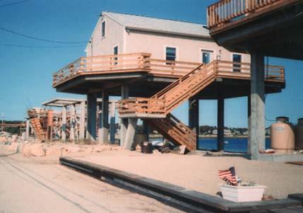
9 Hazard Mitigation - What is it? Any sustained action taken to reduce long-term risk to life and property from a hazard event Mitigation elevated home by the river Preparedness & Response purchase of a police command vehicle Mitigation property acquisition 9

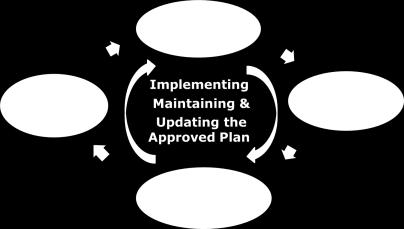
10 Mitigation Planning Cycle Establish a Planning Process Adopt the Plan Implementing Maintaining & Updating your Approved Plan Assess Risks Develop a Mitigation Strategy 10


11 Hazard Mitigation Goal Approach Mitigation as a way of doing business in the Community 11
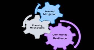
12 Mitigation Plans should not be Stand Alone Plans Mitigation Plans should not be Stand Alone Plans For Multi-Juris Plans, - Local EM is usually primary (and often sole local HMP participant). Participation and Involvement of land use/environmental planners is key to plan development and implementation. Mitigation strategy should be Integrated with other local planning efforts (e.g., storm water, open space, land use) 12
13 Community Capabilities A Community s Capabilities for Mitigation include: Plans - Master plan, land use plan, Storm Water, Open Space Policies and Ordinance - Building codes, zoning Programs - NFIP and CRS Studies and Reports - Flood Insurance Studies, HAZUS Staff and Departments - Community Planners; Building code official; Engineer or public works official; Local floodplain administrator; GIS; Make sure your mitigation actions are based on your community capabilities 13
14 A COMPREHENSIVE RANGE OF ACTIONS STRUCTURAL PROJECTS Acquisition Elevation Retrofits Drainage PLANNING MECHANISMS Zoning Codes Ordinances Open Space Plan NFIP EDUCATION & OUTREACH Public Awareness Outreach Educational Programs NATURAL RESOURCE PROTECTION Stream and Wetland Restoration Erosion Control 14
15 Some examples from NJ HMPs Encourage the development of dunes along the City s beachfront to protect against erosion and storm surge inundation. Survey/upgrade of storm water control system. Upgrade and improve culverts on Way. Retrofit of existing drainage pipes/swales to allow transport of additional stormwater and elimination of street flooding on Road. 15
16 Evaluate/modify/adopt new: floodplain development regulations hillside development regulations open space regulations and protected lands waterfront setback regulations storm water management regulations Stream dumping regulations subdivision and development regulations 16


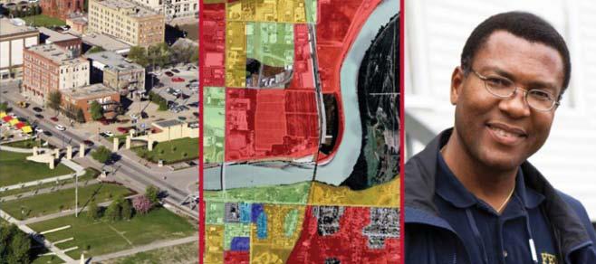
17 NJ Coastal Mapping RiskMAP Updated flood maps for coastal NJ and NYC 17
 is focused on technical aspects of the flood risk program COAT will focus on the outreach elements of the program http://www.region2coastal.")
18 NJ Coastal Mapping - Outreach Advisory Team (COAT) The Coastal Outreach Advisory Team is being established to support the New Jersey and New York City Coastal Flooding Outreach and Education Program Technical Advisory Panel (TAP) is focused on technical aspects of the flood risk program COAT will focus on the outreach elements of the program 18
19 Partnerships Mitigation and Recovery 19
20 NJ Counties beginning HMP Updates Bergen Burlington Essex Hudson Monmouth Ocean Somerset 20
21 Possible Approaches to Planning for Disaster Recovery Adopt a Post-Disaster Recovery Ordinance Integrate Post-Disaster Recovery into the Local Comprehensive Plan Integrate Post-Disaster Recovery into the Local Hazard Mitigation Plan Expand the Recovery Annex of the CEMP to address Post-Disaster Recovery Issues Other Plans, Policies and Programs 21


22 Benefits of Planning for Disaster Recovery Faster and More Efficient Recovery Opportunities to Build Back Better Local Control Over Recovery 22
, Incentives to Target Areas FSU, R.")
23 Examples Phased Reconstruction and Streamlined Permitting or Allowing for a Moratorium Reducing Disaster Vulnerability via Voluntary Mitigation Programs Prioritizing Areas to Focus Redevelopment, Transfer of Development Rights (TDRs), Incentives to Target Areas FSU, R. Deyle,


24 Examples Environmental and Historic Review of Temporary Sites Non-Conforming Use Policy Green Rebuilding Open Space Preservation 24
25 Resources Integrating Best Practices Into Planning (APA): FEMA Hazard Mitigation Planning Region II Coastal Mapping: Flood Map Updates (RIskMAP) New Jersey (and Region II): FEMA-EPA MOA National Disaster Recovery Framework: 25


26 Resources Holistic Disaster Recovery tes/csc.uoregon.edu.opdr/files/ HDR.pdf Planning for Post-Disaster Recovery and Reconstruction iewrecord.do?id=1558 American Planning Association rch/postdisaster/ 26
Floodplain Management Plan 2016 Progress Report
 PREPARED FOR: Borough of Point Pleasant Beach 416 New Jersey Ave. Point Pleasant Beach, NJ 08742 (732) 892-1118 http://www.pointpleasantbeach.org/ PREPARED BY: T&M Associates 11 Tindall Road Middletown,
ORDINANCE NO
 ORDINANCE NO. 9048-17 AN ORDINANCE OF THE CITY OF CLEARWATER (THE CITY), FLORIDA, MAKING AMENDMENTS TO THE CITY S COMPREHENSIVE PLAN IN ACCORDANCE WITH FLORIDA SENATE BILL 1094 (2015) PERIL OF FLOOD ACT
Preparing Hudson River Waterfronts for an Era of Rapid Sea Level Rise
 Preparing Hudson River Waterfronts for an Era of Rapid Sea Level Rise CITY OF KINGSTON TIDAL WATERFRONT FLOODING TASK FORCE Gregg Swanzey Director, Office of Economic Development & Strategic Partnerships,
NJ Department of Environmental Protection
 NJ Department of Environmental Protection COASTAL AND LAND USE PLANNING New Jersey Coastal Management Program Covers NJ coastal waters to limit of tidal influence including 239 municipalities in 19 counties,
Virginia Beach and Sea Level Rise: Where Do We Go From Here?
 Virginia Beach and Sea Level Rise: Where Do We Go From Here? Clay Bernick City of Virginia Beach Environment & Sustainability Office Bayfront Advisory Committee Presentation July 19, 2012 Five Items to
COASTAL MANAGEMENT ELEMENT. Last amended December 6, 2016 as part of the 2016 EAR
 COASTAL MANAGEMENT ELEMENT Last amended December 6, 2016 as part of the 2016 EAR Table of Contents Objective Page 7.1 Development and redevelopment of waterfront properties...7-1 7.2 Agency coordination
City of East Point Comprehensive Floodplain Management Program
 City of East Point Comprehensive Floodplain Management GAFM 2012, 7 th Annual Technical Conference Reza Aral, CFM, CPESC (City of East Point, GA) Shayne Wood, P.E. (CDM Smith) March, 28, 2012 Agenda Overview
Resilient Communities Are Prepared Communities
 Resilient Communities Are Prepared Communities Lincoln Walther, FAICP Planning Director CSA Ocean Sciences Inc. 8502 SW Kansas Avenue, Stuart, Florida 34997 Local Comprehensive Plan Mandated to have adopted
CHATHAM COUNTY S PATH TO SUSTAINABILITY - THE NATURAL RESOURCES SIDE
 CHATHAM COUNTY S PATH TO SUSTAINABILITY - THE NATURAL RESOURCES SIDE GEORGIA ENVIRONMENTAL CONFERENCE SAVANNAH, GEORGIA AUGUST 23, 2012 Jackie Jackson Teel Chatham County-Savannah Metropolitan Planning
THE PROTECTION OF CHATHAM COUNTY S NATURAL RESOURCES - THE POLICY SIDE
 THE PROTECTION OF CHATHAM COUNTY S NATURAL RESOURCES - THE POLICY SIDE SEA GRANT TIDAL CREEK SUMMIT CHARLESTON, SOUTH CAROLINA DECEMBER 5, 2011 Jackie Jackson Teel Chatham County-Savannah Metropolitan
Planning for Historic/Cultural Resources Coastal Resiliency in Connecticut. Presented to CAFM s 3 rd Annual Conference
 Planning for Historic/Cultural Resources Coastal Resiliency in Connecticut Presented to CAFM s 3 rd Annual Conference October 25, 2016 Agenda Introduction and Project Overview Background Historic and Cultural
Planning for Staten. Habitat Restoration and Green Infrastructure. Island s North Shore
 Habitat Restoration and Green Infrastructure Planning for Staten Island s North Shore Community Board 1 March 1, 2018 NYC Parks Forestry, Horticulture, and Natural Resources Funded by the NYS Department
NAI Principles In Gwinnett County
 NAI Principles In Gwinnett County By Cornelius Ani, LSIT, CFM Contributors: Adena Fullard, P.E., CPSWQ Rudresh Bihalli, P.E., CFM Ken Kagy, P.E., CPESC, CPSWQ Ligia Negru, M. Sc., CFM Maja Radovic, CPESC,
EXHIBIT A CITY OF FORT WALTON BEACH, FLORIDA COASTAL MANAGEMENT & CONSERVATION
 EXHIBIT A CITY OF FORT WALTON BEACH, FLORIDA INTRODUCTION The Coastal Management and the Conservation Elements required by Chapter 9J-5.012 and 5.013, F.A.C., respectively, have been combined into one
Functional Areas of Practice AICP EXAM REVIEW. February 20, 2009 Georgia Tech Student Center
 Functional Areas of Practice AICP EXAM REVIEW February 20, 2009 Georgia Tech Student Center Areas of Practice Community development Comprehensive or long range planning Development regulation or administration
MUNICIPAL RESILIENCE PLANNING ASSISTANCE PROJECT
 MUNICIPAL RESILIENCE PLANNING ASSISTANCE PROJECT William R. Rath, Esq. Legal Research Fellow Center for Energy & Environmental law University of Connecticut School of Law 860-570-5058 William.Rath@ UConn.edu
NC Coastal Management Program Update. Mike Lopazanski Policy & Planning Section Chief April 3, 2015
 NC Coastal Management Program Update Mike Lopazanski Policy & Planning Section Chief April 3, 2015 NC Coastal Area Management Act (1974) Balances competing coastal pressures through development permitting
NORTH KINGSTOWN PILOT PROJECT May 9, 2016 North Kingstown Town Council
 Engaging RI Local Governments in Hazard Mitigation and Coastal Resilience NORTH KINGSTOWN PILOT PROJECT May 9, 2016 North Kingstown Town Council Teresa A. Crean, AICP University of Rhode Island Coastal
RESILIENCY, ADAPTATION, & SUSTAINABILITY AT THE CITY OF ST. AUGUSTINE
 RESILIENCY, ADAPTATION, & SUSTAINABILITY AT THE CITY OF ST. AUGUSTINE PROGRAM UPDATE JANUARY 14, 2019 MICHAEL G. CULLUM, P.E. DIRECTOR, PUBLIC WORKS PROGRESSION OF PLANNING FOR RESILIENCY / ADAPTATION
A larger version of this map is located on the last page of this PDF.
 MAP Committee Input McLoughlin Area Draft Vision Map A larger version of this map is located on the last page of this PDF. 1. The map above is intended to portray a vision for the McLoughlin area. It highlights
NC Division of Coastal Management
 November 14, 2016 NC Division of Coastal Management NCBIWA Update NC Coastal Area Management Act (1974) Balances competing coastal pressures through development permitting and creation of a Coastal Resources
Mitigation Action Plan City of Mebane
 Mitigation Action Plan The Mitigation Action Plan for the is divided into two subsections: 7.1 Status of Previously Adopted Mitigation Actions 7.2 New 2015 Mitigation Actions 7.1 Status of Previously Adopted
Rhode Island Shoreline Change Special Area Management Plan
 Rhode Island Shoreline Change Special Area Management Plan Draft Document Outline REVISED 10/12/2017 VOLUME 1 Executive Summary & How to Use this Document (Draft by Dec 2017) 1. Introduction (Revised draft
Empowering Local Action for Coastal Resilience in Massachusetts. Bruce K. Carlisle MA Office of Coastal Zone Management
 Empowering Local Action for Coastal Resilience in Massachusetts Bruce K. Carlisle MA Office of Coastal Zone Management Context Coastal communities continue to face both chronic and acute storm surge, erosion,
Planning for Historic/Cultural Resources Coastal Resiliency in Connecticut. Presented to ASFPM 41 st Annual Conference, Kansas City, MO
 Planning for Historic/Cultural Resources Coastal Resiliency in Connecticut Presented to ASFPM 41 st Annual Conference, Kansas City, MO May 3, 2017 Agenda Introduction and Project Overview Historic and
Getting the Locals to Go Along. Keys to Tulsa s Successful Floodplain Management
 Getting the Locals to Go Along Keys to Tulsa s Successful Floodplain Management Presented by: Ronald D. Flanagan, CFM Principal Planner Flanagan & Associates, LLC Land-Use & Natural Hazards Planning Consultants
Agenda. NPDES Phase II Program (US EPA, 2003 Pending 2009) Costs of Stormwater Management and How to Structure a Stormwater Utility
 Costs of Stormwater Management and How to Structure a Stormwater Utility") Costs of Stormwater Management and How to Structure a Stormwater Utility Richard Claytor, P.E. Horsley Witten Group, Inc How to Fund Your Municipal Stormwater Program April 30, 2009 Peabody Institute Library
Costs of Stormwater Management and How to Structure a Stormwater Utility Richard Claytor, P.E. Horsley Witten Group, Inc How to Fund Your Municipal Stormwater Program April 30, 2009 Peabody Institute Library
Stormwater Regulations & Considerations Morse Study Area. Pam Fortun, P.E. CFM Senior Stormwater Treatment Engineer Engineering Services Division
 Stormwater Regulations & Considerations Morse Study Area Pam Fortun, P.E. CFM Senior Stormwater Treatment Engineer Engineering Services Division Stormwater Regulations Development Considerations Floodplain
Risk Analysis Tools to Support Resilient Design
 Risk Analysis Tools to Support Resilient Design 1755 Cape Ann 6.3: BC WO Paul A. Morey FEMA Region I Woods Hole, MA/NOAA Hurricane & Earthquake Program Manager Maps Commonly used by FEMA and other Federal,
Conservation Corridor Base and Thematic Maps
 Conservation Corridor Base and Thematic Maps August 20, 2010 This project is funded in part by the Virginia Coastal Zone Management Program at the Department of Environmental Quality through Grant #NAO9NOS4190163
NASSAU COUNTY TOWN HALL NEW YORK & CONNECTICUT SUSTAINABLE COMMUNITIES. A Unique Bi-State Partnership to Improve Jobs, Housing and Transportation
 NASSAU COUNTY TOWN HALL NEW YORK & CONNECTICUT SUSTAINABLE COMMUNITIES A Unique Bi-State Partnership to Improve Jobs, Housing and Transportation Police Headquarters Auditorium Mineola, NY December 9 th,
3.7. NEW JERSEY % 6.3% 2.0. Completed Yes Procedural Recommen dation
 C OST E FFICIENT C LIMATE A DAPTATION IN THE N ORTH A TLANTIC 135 3.7.1. LITTLE SILVER, NJ 3.7. NEW JERSEY Population Density Form of Government Category CRS Rating 2226/ sq. mi. Borough Suburban Bayfront
COASTAL MANAGEMENT ELEMENT GOALS, OBJECTIVES, AND POLICIES
 COASTAL MANAGEMENT ELEMENT GOALS, OBJECTIVES, AND POLICIES Goal 5 The City shall protect human life and limit public expenditure in areas subject to destruction by natural disasters and, where appropriate,
Sea Level Rise Workshop #4 May 22, 2018 Venice Local Coastal Program SUMMARY
 Sea Level Rise Workshop #4 May 22, 2018 Venice Local Coastal Program SUMMARY CONTENTS WORKSHOP OVERVIEW... 1 WORKSHOP OBJECTIVES... 2 WHERE AND WHEN... 2 OUTREACH AND ATTENDENCE... 2 FORMAT AND ACTIVITIES...
BRONX TOWN HALL NEW YORK & CONNECTICUT SUSTAINABLE COMMUNITIES. A Unique Bi-State Partnership to Improve Jobs, Housing and Transportation
 BRONX TOWN HALL NEW YORK & CONNECTICUT SUSTAINABLE COMMUNITIES A Unique Bi-State Partnership to Improve Jobs, Housing and Transportation Fordham University Bronx, NY January 23, 2012 PARTNERSHIP FOR SUSTAINABLE
Staff will be providing an overview of the project need, purpose and intent for consideration as part of the Amendment cycle.
 Agenda Item D-2 City of Tacoma Planning and Development Services To: Planning Commission From: Stephen Atkinson, Planning Services Division Subject: Open Space Corridors Project Meeting Date: March 1,
Part 4: CRS Stormwater Management Activity (450) and Urban Flooding Best Practices
 and Urban Flooding Best Practices") Coastal Resilience through Community Engagement Webinar Series Part 4: CRS Stormwater Management Activity (450) and Urban Flooding Best Practices 1:00 2:30pm CT 8 Today s Moderator Chad Berginnis, CFM
Coastal Resilience through Community Engagement Webinar Series Part 4: CRS Stormwater Management Activity (450) and Urban Flooding Best Practices 1:00 2:30pm CT 8 Today s Moderator Chad Berginnis, CFM
Mapping and the 2013 Colorado Floods. Mapping before, during, and after
 Mapping and the 2013 Colorado Floods Mapping before, during, and after Presented by Outline 2013 Floods Floodplain Mapping Before During After 20 counties 21,000 households 6000 sq. mi. 2,132 NFIP claims
Resilience on the Great Lakes: A Tale of Two Counties
 Resilience on the Great Lakes: A Tale of Two Counties James C. Schwab, AICP Manager, APA Hazards Planning Research Center ASFPM No Adverse Impacts Seminar Milwaukee August 19, 2014 Why this approach? Comparisons
Discussion objectives
 APPROACHES TO MITIGATION OF DISASTER RISK AND NEED FOR INFORMATION ON LOSS ESTIMATION N.M.S.I.ARAMBEPOLA PROGRAM MANAGER ASIAN URBAN DISASTER MITIGATION PROGRAM Discussion objectives : Explain the concept
Riparian Buffer on the Bushkill Creek. Policies
 Riparian Buffer on the Bushkill Creek Riparian buffers provide numerous benefits to landowners and the community by protecting groundwater recharge areas, providing flood control, providing stormwater
NEW YORK STATE WATER RESOURCES INSTITUTE Department of Biological and Environmental Engineering
 NEW YORK STATE WATER RESOURCES INSTITUTE Department of Biological and Environmental Engineering 230 Riley-Robb Hall, Cornell University Tel: (607) 254-7163 Ithaca, NY 14853-5701 Fax: (607) 255-4449 http://wri.cals.cornell.edu
Towards a Resilient Stormwater Future: Building Back from Hurricane Irene and Tropical Storm Lee. October 15, 2015 VUSP Symposium
 Towards a Resilient Stormwater Future: Building Back from Hurricane Irene and Tropical Storm Lee October 15, 2015 VUSP Symposium Russ Dudley, P.E., LEED AP Environmental Engineer Presentation Outline Impacts
NYC DEP s Approach to Flood Mitigation: The Local Flood Analysis (LFA) Process
 Process") NYC DEP s Approach to Flood Mitigation: The Local Flood Analysis (LFA) Process Milone & MacBroom, Inc. Jenabay Sezen, EIT Connecticut Association of Floodplain Managers October 25, 2016 Agenda Introduction
NYC DEP s Approach to Flood Mitigation: The Local Flood Analysis (LFA) Process Milone & MacBroom, Inc. Jenabay Sezen, EIT Connecticut Association of Floodplain Managers October 25, 2016 Agenda Introduction
Virginia s Tidal Wetlands: Managing for Resilience. Pam Mason
 Virginia s Tidal Wetlands: Managing for Resilience Pam Mason Image: Skip Stiles, Wetlands Watch PAST: City of Norfolk shallow water and wetlands Fill. Maersk Nauticus Chrysler Museum Mc Arthur Mall Opera
CRITICALFACILITIESASSESSMENT IN SOUTHEASTERN CONNECTICUT STRATEGIES FOR ALL HAZARDS RESILIENCE
 CRITICALFACILITIESASSESSMENT IN SOUTHEASTERN CONNECTICUT STRATEGIES FOR ALL HAZARDS RESILIENCE Presented by: David Murphy, P.E., CFM, Milone & MacBroom, Inc. October 25, 2017 Agenda Project Background
City of West Palm Beach. Floodplain Management Plan Draft Action Plan August 3, 2016
 City of West Palm Beach Floodplain Management Plan Draft Action Plan August 3, 2016 The projects in this draft Action Plan are in order by the six categories of floodplain management activities identified
Best Practices Appendix: Waterfront Communities
 Redevelopment Ready Communities Best Practices Appendix: Waterfront Communities revised September 2014 Waterfront RRC defined The purpose of these additional criteria is to provide waterfront communities
HAZARD MITIGATION GOALS AND OBJECTIVES
 SEWRPC Community Assistance Planning Report No. 282, 2nd Edition CITY OF MILWAUKEE ALL HAZARDS MITIGATION PLAN UPDATE Chapter IV HAZARD MITIGATION GOALS AND OBJECTIVES [NOTE: Throughout this plan update
Existing Conditions and Environmental Consequences Floodplains
 3.9 Environmental Consequences 3.8 3.8.1 WHAT ARE FLOODPLAINS? are low-lying areas adjacent to rivers, streams, and other waterbodies that are susceptible to inundation (flooding) during rain events. These
CAMA LAND USE PLAN TOWN OF KITTY HAWK IMPLEMENTATION STATUS REPORT 2013
 Post Office Box 549 101 Veterans Memorial Drive Kitty Hawk, NC 27949 Phone (252) 261-3552 Fax (252) 261-7900 www.townofkittyhawk.org CAMA LAND USE PLAN TOWN OF KITTY HAWK IMPLEMENTATION STATUS REPORT 2013
Local Waterfront Revitalization Programs
 Local Waterfront Revitalization Programs Jaime Ethier Coastal Resources Specialist Mid-Hudson Region Supervisor April 27, 2017 April 27, 2017 2 NYS Coastal Area Roughly 1000 feet inland from these waters
What Planners Do. Heather Wade, Coastal Planning Specialist Texas Sea Grant
 What Planners Do Heather Wade, Coastal Planning Specialist Texas Sea Grant What Planners Do Seminar Series Department of Landscape Architecture and Urban Planning College of Architecture ABOUT ME B.S.
Climate ready cities. Policy Information Brief 2. Key Points
 Policy Information Brief 2 Climate ready cities NCCARF s evidence-based Policy Information Briefs address key challenges to effective adaptation to Australia s variable and changing climate. They provide
Appendix E Preliminary Location Hydraulic Study
 Appendix E Prepared for: State of Alaska Department of Transportation and Public Facilities Prepared by: HDR Alaska, Inc. 2525 C Street, Suite 305 Anchorage, Alaska 99503 February 2014 This page intentionally
Impervious Cover Project for Climate Resilience in New Jersey
 Impervious Cover Project for Climate Resilience in New Jersey Christopher C. Obropta, Ph.D., P.E. obropta@envsci.rutgers.edu www.water.rutgers.edu February 26, 2016 Rutgers Cooperative Extension Rutgers
ASFPM 2015 Conference June 3, 2015 Living with the River in Lyons, Colorado. Darrin Punchard, AICP, CFM Principal Risk & Resilience
 ASFPM 2015 Conference June 3, 2015 Living with the River in Lyons, Colorado Darrin Punchard, AICP, CFM Principal Risk & Resilience 1 Lyons, Colorado Located 50 miles north of Denver; 12 miles north of
Regional Open Space Conservation Plan. Regional Staff Committee January 18, 2018
 Regional Open Space Conservation Plan Regional Staff Committee January 18, 2018 Schedule We are here Task 1 - Stakeholder Input & Work Plan Dev. v z 2016 2017 2018 Oct Nov Dec Jan Feb Mar Apr May Jun Jul
Auke Bay Area Plan. Complete List of Goals and Policies for the Auke Bay Area Plan
 Auke Bay Area Plan Complete List of Goals and for the Auke Bay Area Plan Recreation Goals & Pedestrian Access Goal 1: Link the Auke Bay area with an accessible system for recreation and transportation.
PLANNING COMMISSION Draft Minutes August 5, 2015
 PLANNING COMMISSION Draft Minutes August 5, 2015 Members Present: Members Absent: Others Present: Sally Miller, Paul Highberg, Marilyn Spaulding, Nick Scheu, Sam Segal, Susan Boston Keri Cole Ned Swanberg,
7th Avenue Creek Master Plan Development Project. City of St. Charles, IL. IAFSM CONFERENCE March 14, 2018 MARKET
 7th Avenue Creek Master Plan Development Project MARKET City of St. Charles, IL IAFSM CONFERENCE March 14, 2018 7 TH AVENUE CREEK PROJECT AREA 2 2008 RAIN EVENT 3 RESIDENTIAL STRUCTURE FLOODING COMMERCIAL
SAN RAFAEL GENERAL PLAN 2040 INTRODUCTION AND OVERVIEW
 SAN RAFAEL GENERAL PLAN 2040 INTRODUCTION AND OVERVIEW Steering Committee Presentation February 14, 2018 Purpose of General Plan Guide land use and development decisions Coordinate transportation, infrastructure,
TRANSPORTATION ELEMENT GOALS, OBJECTIVES, AND POLICIES
 TRANSPORTATION ELEMENT GOALS, OBJECTIVES, AND POLICIES GOAL 2 The City shall provide a safe, convenient, effective, and energy efficient multimodal transportation system which is coordinated with the Future
SEMSWA s Role in the Land Development Process
 SEMSWA s Role in the Land Development Process One of SEMSWA s responsibilities is to ensure that any new development or redevelopment within its service area is designed and constructed in compliance with
National Association of Conservation Districts. Kris Hoellen Vice President, Sustainable Programs The Conservation Fund September 19, 2013
 National Association of Conservation Districts Kris Hoellen Vice President, Sustainable Programs The Conservation Fund September 19, 2013 Our Mission The Conservation Fund forges partnerships to conserve
WASHINGTON COUNTY OREGON
 WASHINGTON COUNTY OREGON LONG RANGE PLANNING DIVISION North Bethany Subarea Stream Corridors: Existing Regulations In Oregon, there is a distinct difference between the land use rules that apply in rural
A BLUEPRINT FOR BROCKTON A CITY-WIDE COMPREHENSIVE PLAN
 A BLUEPRINT FOR BROCKTON A CITY-WIDE COMPREHENSIVE PLAN Public Meeting October 2016 1 Plan Summary and Discussion Public Meeting May 4 2017 City of Brockton Bill Carpenter, Mayor Department of Planning
Genesee/Finger Lakes Regional Planning Council (G/FLRPC) February Webinar Series. Regional Planning Councils. G/FLRPC - February 10, 2016, 12:00-1:00
 February Webinar Series. Regional Planning Councils. G/FLRPC - February 10, 2016, 12:00-1:00") Genesee/Finger Lakes Regional Planning Council (G/FLRPC) February Webinar Series G/FLRPC - February 10, 2016, 12:00-1:00 Exploring Census Data Tools - February 17, 2016, 12:00-1:00 Economic Development
Genesee/Finger Lakes Regional Planning Council (G/FLRPC) February Webinar Series G/FLRPC - February 10, 2016, 12:00-1:00 Exploring Census Data Tools - February 17, 2016, 12:00-1:00 Economic Development
Streets for People, Place-Making and Prosperity. #TOcompletestreets
 COMPLETE STREETS FOR TORONTO Streets for People, Place-Making and Prosperity COMPLETE STREETS: A NEW APPROACH A Complete Streets design approach considers the needs of all users people who walk, bicycle,
When planning stormwater management facilities, the following principles shall be applied where possible.
 2.0 Principles When planning stormwater management facilities, the following principles shall be applied where possible. 2.0.1 Drainage is a regional phenomenon that does not respect the boundaries between
Managing Stormwater Runoff with Green Infrastructure "Enhancing Community Resiliency to the Changing Climate"
 Managing Stormwater Runoff with Green Infrastructure "Enhancing Community Resiliency to the Changing Climate" Presented at Stormwater Management on the Whale Pond Brook Watershed Meeting Christopher C.
WEATHER IT TOGETHER. The Annapolis Model for Cultural Resource Adaptation Planning. Cultural Resources, Disaster Resilience, and Climate Uncertainty
 WEATHER IT TOGETHER The Annapolis Model for Cultural Resource Adaptation Planning Cultural Resources, Disaster Resilience, and Climate Uncertainty Historic Annapolis A Colonial Capital: National Landmark
CITY OF CHARLOTTESVILLE, VIRGINIA CITY COUNCIL AGENDA
 CITY OF CHARLOTTESVILLE, VIRGINIA CITY COUNCIL AGENDA Agenda Date: December 16, 2013 Action Required: Adoption of Resolution Presenter: Staff Contacts: Title: James E. Tolbert, AICP, Director of NDS James
Physical Approaches to Flood Mitigation
 Physical Approaches to Flood Mitigation ational Academy of Sciences /19/2017 Chicago Area Before Development Widespread Flooding Waterways and Marshes Absorbent Ground Early settlers came to this location
Proposed Comprehensive Plan Strategies DRAFT for discussion June 28, 2017
 Proposed Comprehensive Plan Strategies DRAFT for discussion June 28, 2017 Land Use Rural Areas Refine the Farm and Forest area (FF) Update FF boundaries to account for existing lots less than five acres
Stafford County Strategic Plans
 Stafford County Strategic s Strategic Department Description Date Adopted Board of Supervisors Priorities Fiscal Responsibility Education Public Safety Infrastructure Economic Development Service Excellence
Green Infrastructure Codes and Ordinances
 1 Green Infrastructure Codes and Ordinances Emily Vail Hudson River Estuary Program NYS Department of Environmental Conservation New York State Water Resources Institute at Cornell University March 19,
Coastal Planning in Texas. Tony Williams Senior Director of Planning Coastal Resources Division Texas General Land Office
 Coastal Planning in Texas Tony Williams Senior Director of Planning Coastal Resources Division Texas General Land Office e The Texas General Land Office (GLO) and the Texas Coast Since 1836: Manager of
Working Group Meeting
 April 4,, 2017 Parks Operations Bldg Working Group Meeting Arts Districts Overview Stormwater/RPA/Stream Considerations First Principles Agenda 7:00pm 7:05pm 7:10pm 7:40pm 8:30pm 9:40pm 9:45pm Welcome
Libby Zemaitis October 18, 2017 Climate Outreach Specialist, NYS DEC Hudson River Estuary Program
 1 Supporting Hudson Riverfront communities as Climate-Adaptive Leaders Libby Zemaitis October 18, 2017 Climate Outreach Specialist, NYS DEC Hudson River Estuary Program The Hudson River Estuary Program
TOWN OF OCEAN RIDGE 6450 NORTH OCEAN BOULEVARD OCEAN RIDGE, FLORIDA (561) FAX (561)
 FAX (561)") TOWN OF OCEAN RIDGE 6450 NORTH OCEAN BOULEVARD OCEAN RIDGE, FLORIDA 33435 www.oceanridgeflorida.com (561) 732-2635 FAX (561) 737-8359 JAMES A. BONFIGLIO MAYOR, CHAIRMAN OF COMMISSION JAMES S. TITCOMB TOWN
TOWN OF OCEAN RIDGE 6450 NORTH OCEAN BOULEVARD OCEAN RIDGE, FLORIDA 33435 www.oceanridgeflorida.com (561) 732-2635 FAX (561) 737-8359 JAMES A. BONFIGLIO MAYOR, CHAIRMAN OF COMMISSION JAMES S. TITCOMB TOWN
Low Impact Development in Coastal South Carolina: A Planning and Design Guide
 Low Impact Development in Coastal South Carolina: A Planning and Design Guide ACE Basin & North Inlet-Winyah Bay National Estuarine Research Reserves Network of 28 Reserves NOAA Program Research, Stewardship,
Village of Freeport. The Boating and Fishing Capital of the East Incorporated Area Square Miles. Approximately 20 miles of bulkhead
 Village of Freeport The Boating and Fishing Capital of the East Incorporated Area - 4.93 Square Miles 10.4 Miles of Waterways 30 Navigable Canals Approximately 20 miles of bulkhead Largest Maritime Center
Catherine Bray John Buss Manager City of Tallahassee/Stormwater Management
 Florida Stormwater Association EXCELLENCE AWARD for STORMWATER PROGRAMS and PROJECTS NOMINATION FORM I. Nomination Information Nomination Category (please check only one box): Program (Department/Division)
Public Open House. Overview of the Downtown Plan Official Plan Amendment April 23, 2018
 Public Open House Overview of the Downtown Plan Official Plan Amendment April 23, 2018 1 A 25-Year Plan for Downtown To ensure growth contributes positively to Toronto s Downtown as a great place to live,
City of Waco Stormwater Management Regulations
 1.0 Applicability: City of Waco Stormwater Management Regulations These regulations apply to all development within the limits of the City of Waco as well as to any subdivisions within the extra territorial
City of Petersburg, VA Stormwater Utility Frequently Asked Questions
 Q. What is stormwater runoff? A. Stormwater runoff is the water that flows off roofs, driveways, parking lots, streets and other hard surfaces during rain storms. Stormwater runoff is also the rain that
Title slide..poughkeepsie Planning Initiatives POUGHKEEPSIE PLANNING INITIATIVES
 Title slide..poughkeepsie Planning Initiatives Overview Revitalization Projects Waterfront Redevelopment Strategy Local Waterfront Revitalization Program Update Kaal Rock Connector Fallkill Creek Plan
Executive Office of Energy and Environmental Affairs Massachusetts Vulnerability Preparedness Program. June 6, 2018
 Executive Office of Energy and Environmental Affairs Massachusetts Vulnerability Preparedness Program June 6, 2018 Presentation Outline: 1. What Natural Hazards Impact Falmouth 2. Coastal Resiliency Efforts
TO: Port of Orcas FROM: Tina Whitman, Science Director SUBJECT: Master Plan Update DATE: September 7, 2018
 TO: Port of Orcas FROM: Tina Whitman, Science Director SUBJECT: Master Plan Update DATE: September 7, 2018 Friends of the San Juans appreciates the opportunity to provide input to the Port of Orcas Master
Getting to Resilience webinar
 Getting to Resilience webinar A brief description of two NJDEP Projects: Resilient Coastal Communities Initiative & Municipal Public Access & Resiliency Small Grants Program June 26, 2014 Marty Rosen NJ
LEGAL & POLICY ANALYSIS TO SUPPORT RESILIENCE MEASURES. CEEL Tasks
 LEGAL & POLICY ANALYSIS TO SUPPORT RESILIENCE MEASURES William R. Rath, Esq. Legal Research Fellow Center for Energy & Environmental law University of Connecticut School of Law 860-570-5058 William.Rath@
Community Recovery Planning New York
 Community Recovery Planning New York APA Conference; May 9, 2017 Lawrence Frank Atkins North America Barry Hokanson 22 May 2017 1 What is a disaster? Extraordinary event that disrupts a city or area s
Introducing Green Infrastructure for Coastal Resilience
 Introducing Green Infrastructure for Coastal Resilience National Oceanic and Atmospheric Administration (NOAA) Office for Coastal Management Gloucester, MA Office of Travel Courtesy, Tim Grafft What Is
Conservation Corridor Planning and Green Infrastructure Themes
 Conservation Corridor Planning and Green Infrastructure Themes Prepared by the Green Infrastructure Center Inc. and the Northern Virginia Regional Commission February 22, 2011 Brief Overview Project Background
PLANNED UNIT DEVELOPMENT Date: April 5, 2018
 PLANNED UNIT DEVELOPMENT Date: April 5, 2018 DEVELOPMENT NAME SUBDIVISION NAME LOCATION Robert Myers Robert Myers 2955 and 2989 Dauphin Street (Southeast corner of Dauphin Street and Sage Avenue) CITY
Mitigation + Adaptation Strategies for Historic Structures and Sites
 Mitigation + Adaptation Strategies for Historic Structures and Sites Adrienne Burke, Esq., MSAS, LEED AP+ Executive Director, Riverside Avondale Preservation, Jacksonville, FL Cultural Resources, Disaster
STORMWATER MANAGEMENT CODES ANALYSIS RICHLAND COUNTY, SC SITE PLANNING ROUNDTABLE
 STORMWATER MANAGEMENT CODES ANALYSIS RICHLAND COUNTY, SC SITE PLANNING ROUNDTABLE Codes analyses for each subcommittee were completed to assist participants of the Richland County Site Planning Roundtable.
Building Ecological Solutions to Coastal Community Hazards: Guidance and NJ Coastal Community Assistance
 Building Ecological Solutions to Coastal Community Hazards: Guidance and NJ Coastal Community Assistance Stacy Small-Lorenz National Wildlife Federation Restore America s Estuaries Summit New Orleans,
IMPLEMENTING SOMERSET COUNTY S INVESTMENT FRAMEWORK
 IMPLEMENTING SOMERSET COUNTY S INVESTMENT FRAMEWORK SMART CONSERVATION THROUGH SMART GROWTH NJ LAND CONSERVATION RALLY March 22, 2014 Laurette Kratina, PP, AICP, Supervising Planner Somerset County Planning